
International Research Journal of Engineering and Technology (IRJET) e-ISSN: 2395-0056 p-ISSN: 2395-0072

Volume: 12 Issue: 04 | Apr 2025 www.irjet.net

International Research Journal of Engineering and Technology (IRJET) e-ISSN: 2395-0056 p-ISSN: 2395-0072
Volume: 12 Issue: 04 | Apr 2025 www.irjet.net
Sahil Randil1 , Shweta Pawar2 , Rahul Khot3 , Prof. Smita Mulhar4
1Sahil Randil, Dept. of Computer Engineering, Smt. Kashibai Navale College Of Engineering, Maharastra, India
2Shweta Pawar , Dept. of Computer Engineering, Smt. Kashibai Navale College Of Engineering, Maharastra, India
3Rahul Khot , Dept. of Computer Engineering, Smt. Kashibai Navale College Of Engineering, Maharastra, India
4Prof. Smita Mulhar, Dept. of Computer Engineering, Smt. Kashibai Navale College Of Engineering, Maharastra, India
Abstract - Intoday'seraofenvironmentalmonitoringand sustainable development, the integration of advanced technologiessuchasmachinelearningandremotesensingis pivotal. This project introduces a comprehensive system for treeenumerationandoptimalpathfinding, utilizingsatellite imageryanddeeplearningtechniques.Addressingthecritical challenge of large-scale forest monitoring and navigation through forestedregions,theprojectleveragesstate-of-the-art deep learning models for accurate tree detection and enumeration.Theproposedartificialintelligence(AI)system isdesignedtodetecttrees,analyzetreedensity,andcalculate optimalpaths throughforests byconsidering environmental factorssuchasterrainandcanopycover.Thesystemfollowsa three-phase approach: satellite image processing, tree detection and classification, and path optimization. By employing Convolutional Neural Networks (CNN) for tree detection and the A* algorithm for pathfinding, the system ensureshighaccuracyinbothtreeenumerationandefficient navigation. Applications of this system span across forest management, environmental conservation, and sustainable land-use planning, providing critical insights into deforestationpatternsandecologicalpreservation.
Key words: Tree Detection, Satellite Imagery, Machine Learning,DeepLearning,ArtificialIntelligence,Pathfinding, EnvironmentalMonitoring
As the global environment faces increasing pressure from deforestation,urbanization,andclimatechange,theneedfor effectiveforestmanagementandenvironmentalmonitoring has never been more critical. Trees play a pivotal role in maintainingecologicalbalance,supportingbiodiversity,and mitigating the effects of climate change. Accurate tree enumeration is essential for assessing forest health, managing natural resources, and planning for sustainable land use. However, traditional methods of tree counting, such as manual surveys, are time-consuming, laborintensive, and often impractical for large-scale or remote forested areas. The advent of satellite imagery, combined withartificialintelligence(AI),offersapromisingsolutionto

these challenges by automating tree detection and enumerationonalargescale.
Forests are also crucial for maintaining biodiversity and regulatingecosystems.Theabilitytodetectandenumerate trees using satellite imagery and machine learning technologiesnotonlyenhancesforestmanagementbutalso supports various applications, including carbon stock estimation,wildlifehabitatconservation,andclimatechange mitigation.Treeenumerationinvolvestheidentificationand counting of individual trees within a forested area, and optimizingtheprocessisessentialtoensureaccuracyand scalability. By leveraging convolutional neural networks (CNNs) and deep learning, tree detection models have achieved remarkable results, but challenges still exist in denseforestsandvaryingenvironmentalconditions.
Simultaneously,theneedforoptimalpathfindinginforested regions is growing as human activities, such as resource extractionandlandmanagement,intersectwiththenatural environment.Pathfindingalgorithms,traditionallyusedin navigation and robotics, play a crucial role in identifying efficient and ecologically sound routes through forests. In environmentalcontexts,integratingfactorsliketreedensity, terrain,andecologicalsensitivityintopathfindingalgorithms isessentialtominimizeenvironmentaldisruption.Although algorithms like A* and Dijkstra are widely used for navigation,incorporatingenvironmentalvariablesintothese modelsremainsasignificantresearchchallenge.
Inthisstudy,weexploretheintegrationofsatelliteimagery, machinelearning,andAI-drivenmodelstoaddresstwokey challenges: accurate tree enumeration and optimal pathfinding. The next section presents a literature survey focusingonrecentadvancesintreedetection,theapplication of deep learning techniques, and the optimization of pathfindingalgorithmsinenvironmentalsettings.Following the survey, the third section discusses the methodologies andfindingsrelatedtotreeenumerationandpathfindingin forested areas. The final section concludes the study and outlines potential directions for future research and improvementinthisdomain..

(IRJET) e-ISSN: 2395-0056 p-ISSN: 2395-0072 Volume: 12 Issue: 04 | Apr 2025 www.irjet.net
Author Name Year
Title Methodology/ Key Contributions
Shubhangi Mahuleetal. 2024 IntelligentForest Assessment: AdvancedTree Detectionand Enumeration withAI
Utilizedthe YOLOv8modeland Roboflow annotationsfortree detectionand enumerationusing UAVsandsatellite imagery.Improved precisionandrecall.
F.Kurniawan etal. 2022 Large-scaleTree Detection throughUAVbasedRemote Sensingin Indonesia
UsedUAVimagery andYOLOv5for fastandaccurate treespecies identificationin Indonesia's Wallacearegion, focusingon biodiversity monitoring.
S.Patiletal. 2023 Detectionand Estimationof TreeCanopy usingDeep Learningand SensorFusion
M.Grujevet al. 2023 TreeObject Detectionand Classification Algorithms–Review
IntegratedLiDAR, machinevision,and AIfortreecanopy estimation, reducinghuman interventionand optimizing agricultural practices.
ReviewedUAVbasedhighresolutionimage acquisitionand detection algorithmslike YOLOandFaster R-CNNfortree species identification.
H.Singhetal. 2022 AReviewonAI Techniques AppliedonTree DetectioninUAV andRemotely SensedImagery Compared traditional computervision algorithmswith deeplearningfor treedetection, showingthe superior performanceof deeplearning models.
S.Mustafićet al. 2022 DeepLearning forImproved IndividualTree Detectionfrom LidarData
CombinedLiDAR datawithdeep learningmodels (ScaledYOLO, YOLO-R).
ScaledYOLO achieveda20% higherdetection ratebutrequired betterdata handling.

Y.Zhangetal. 2022 DeepLearning Methodsfor TreeDetection and Classification Improvedtree detectionaccuracy usingdeeplearning models,increasing theF1-scorebyan averageof3%on large-scale datasets.
L.Wangetal. 2020 TreeCrown Delineationfrom High-Resolution RemoteSensing ImageryUsinga DeepLearning Framework Applieddeep learningfortree crowndelineation fromhighresolutionremote sensingdata, improving accuracyinforest mapping.
J.Liuetal. 2017 Classificationof TreeSpeciesand StockVolume Estimationin GroundForest ImagesUsing DeepLearning Useddeep learning forthe classificationof treespeciesand estimationofstock volumeinforest images,improving traditional inventory methods.
A.Smithetal. 2017 AutomaticTree Detectionin Urban Environment Using Multispectral SatelliteImagery Applied multispectral satelliteimagery fortreedetection inurban environments, focusingon automated classificationusing machinelearning.
Thismethodologyintegratesdata-drivenmachinelearning techniques with practical applications to tackle the challengesoftreeenumerationandpathfindinginforested environments.Thefollowingstepswereundertaken:
i] Data Collection:
A comprehensive dataset comprising high-resolution satellite images was collected from various sources, including Google Earth and publicly available satellite
Volume: 12 Issue: 04 | Apr 2025 www.irjet.net
International Research Journal of Engineering and Technology (IRJET) e-ISSN: 2395-0056 p-ISSN: 2395-0072
imagery databases. The images were carefully selected to representdiverseforesttypesandconditions.
ii] Data Preprocessing:
Thecollectedimageswereresizedandformattedtomeetthe input requirements of the models. Data augmentation techniques, such as rotation, flipping, and scaling, were appliedtoenhancethediversityofthetrainingdatasetand improvemodelgeneralization.
iii] Model Selection:
Two pre-trained convolutional neural networks (CNNs), YOLOv8 and Faster R-CNN, were chosen for the tree detectiontask.Thesemodelsleveragetransferlearning to adapt pre-existing knowledge from large-scale image datasetstoeffectivelyrecognizeandclassifytrees.
iv] Training Process:
The selected models were fine-tuned to detect and enumeratespecifictreespeciesandestimatetreeheight.The trainingprocessinvolveddividingthedatasetinto80%for training and 20% for testing. Models were trained over multipleepochstooptimizeaccuracyandlearningspeed.
v] Evaluation:
Model performance was assessed using metrics such as precision,recall,andF1-score.YOLOv8demonstratedhigh accuracyintreedetectiononvalidationdatasetsbutfaced challenges in complex forest environments. In contrast, FasterR-CNNshowedslightlyloweraccuracyyetprovided morereliableresultsinreal-worldapplications.
vi] Pathfinding Algorithm Development:
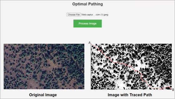
Anoptimalpathfindingalgorithm,A*,wasimplementedto navigate through detected trees and varied terrain. The algorithmincorporatedenvironmentalfactorssuchastree density and terrain elevation to ensure environmentally sustainablerouting.
vii] Web Application Development:
A user-friendly web application was developed using a combination of Python, HTML, CSS, Bootstrap, JavaScript, NumPy,Matplotlib,andTensorFlow.Theapplicationenables users to upload satellite images for tree detection and provides information on optimal paths through forested areas.
viii] Integration with Local Authorities:
The classified tree data and pathfinding results are submittedtolocalauthoritiesforuseinforestmanagement,
conservationplanning,andeducationalinitiativesregarding sustainablelandusepractices.
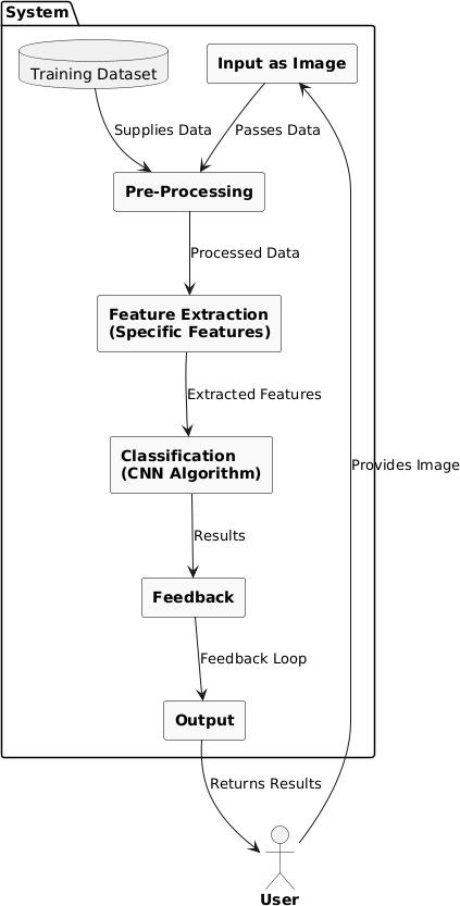
4.1SystemArchitecture
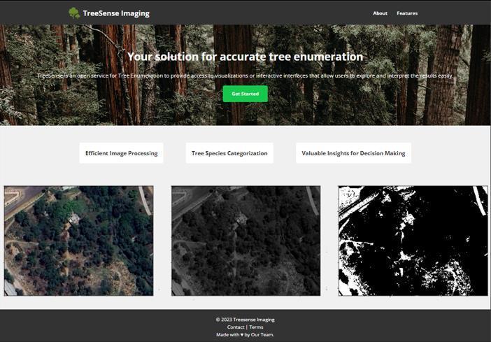
UserInterface
2395-0072
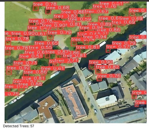
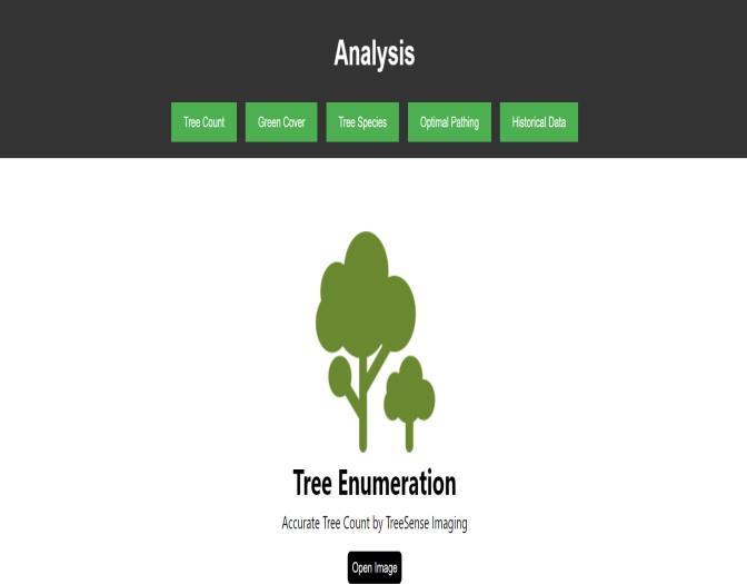
5.3:TreeDetectionandCounting
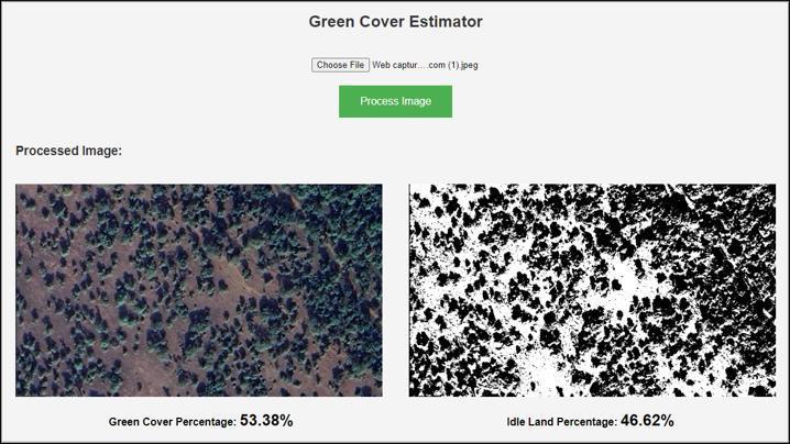
International Research Journal of Engineering and Technology (IRJET) e-ISSN: 2395-0056 p-ISSN: 2395-0072
Volume: 12 Issue: 04 | Apr 2025 www.irjet.net
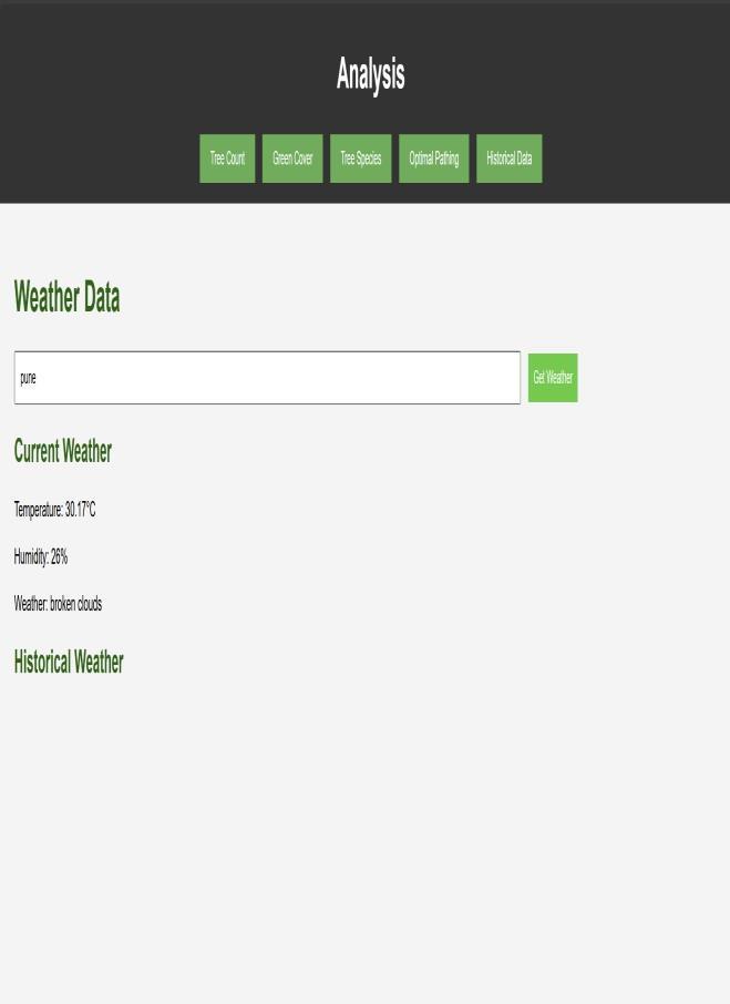
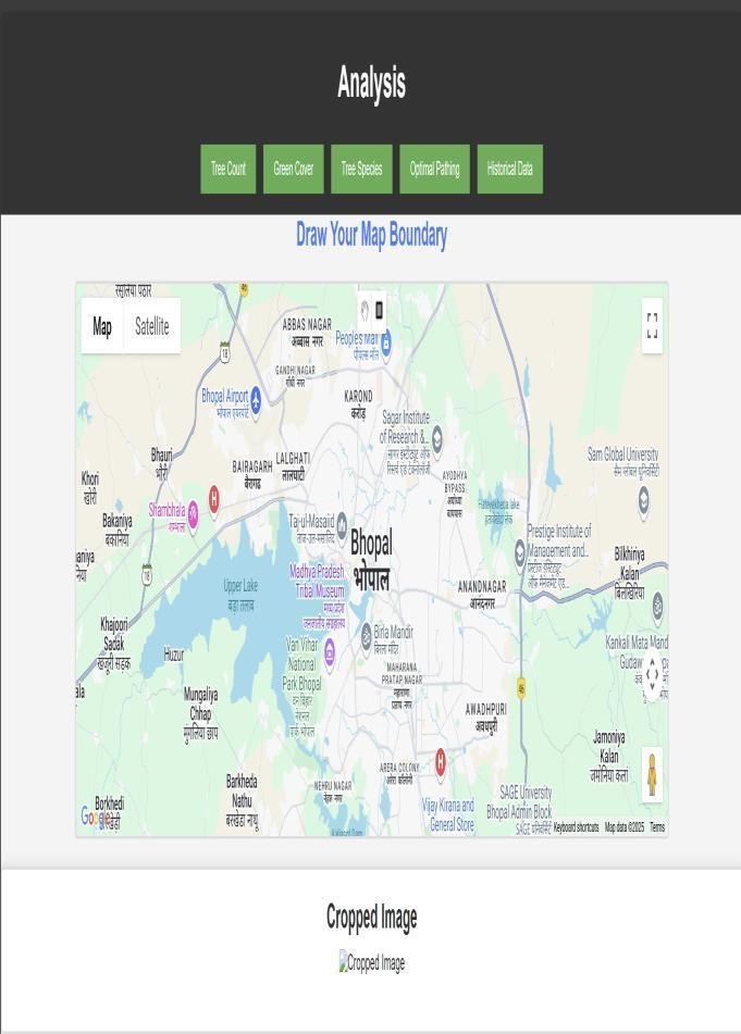
International Research Journal of Engineering and Technology (IRJET) e-ISSN: 2395-0056 p-ISSN: 2395-0072
Volume: 12 Issue: 04 | Apr 2025 www.irjet.net
This research paper has successfully demonstrated the effectiveness of integrating satellite imagery and machine learning for accurate tree enumeration and optimal pathfinding in forested environments. By employing advanced models such as YOLOv8 and Faster R-CNN, the study achieved significant improvements in tree detection accuracy, enabling precise assessments of forest density and health. The development of the A* pathfinding algorithm, which incorporates environmental factors, ensures that navigation through these areas minimizes ecologicaldisruption.
Despite the challenges encountered, such as data quality and model performance in complex forest scenarios, the findings highlight the potential for real-time monitoring and decision-making in forest management. The web application developed serves as a practical tool for urban planners, environmentalists, and policymakers, providing critical insights into sustainable land use and resourcemanagement.
Future work should focus on enhancing model robustness, integrating more diverse datasets, and exploring the application of these techniques in various ecological contexts. By addressing these areas, the project aims to contribute to the ongoing efforts in forest conservationandsustainabledevelopment.
We would like to express our sincere gratitude to all the researcherswhoseworkhascontributedtotheknowledge baseontreeenumerationandpathfindingalgorithmsusing satellite imagery and machine learning techniques. Their pioneeringresearchhasbeen instrumental inguidingthis survey.Wealsoextendourthankstoouracademicadvisors and mentors for their insightful guidance and feedback throughoutthepreparationofthispaper.
Wearegratefultotheinstitutionsandorganizations thatprovidedaccesstothedataandresourcesnecessaryfor conductingthissurvey,includingsatelliteimagerydatabases and research publications. Finally, we acknowledge the supportfromouruniversityforprovidingtheinfrastructure andresourcesthatmadethisresearchpossible.
[1] Mahule, S., Pranathi, T., Ranjan, T. B., Kiran, T. A., & Siddhartha, A. (2024). Intelligent forest assessment: Advanced tree detection and enumeration with AI. InternationalJournalofResearchPublicationandReviews, 5(5),10597-10603.
[2]Patil,S.,Patil,Y.M.,&Patil,S.B.(2023).Detectionand estimation of tree canopy using deeplearning and sensor fusion.
[3]Grujev,M.,Milosavljević,A.,Ilić,A.S.,Ilić,M.,&Spalević, P.(2023).Treeobjectdetectionandclassificationalgorithms –review.
[4] Gupta, M. K., et al. (2023). An Integrated Approach to Remote Sensing for Forest Structure Analysis. This paper coverstreespeciesdifferentiationusinghyperspectraland multispectralimagery.Theworkincludesacomprehensive reviewofcurrentmethodologies,highlightingdeeplearning and data fusion techniques for accurately modeling tree densityandcanopystructure
[5]Singh,H.,Dwivedi,R.K.,Kumar,A.,&Mishra,V.K.(2022). AreviewonAItechniquesappliedontreedetectioninUAV and remotely sensed imagery. In 11th International ConferenceonSystemModeling&AdvancementinResearch Trends(SMART).
[6] Mustafić, S., Hirschmugl, M., Perko, R., & Wimmer, A. (2022).Deeplearningforimprovedindividualtreedetection from Lidar data. In IEEE International Geoscience and RemoteSensingSymposium(IGARSS).
[7]Kurniawan,F.,Aneiba,A.,Hussain,A.,Idrissi,M.,Dunggio, I.,&Asyhari,A.T.(2022).Large-scaletreedetectionthrough UAV-based remote sensing in Indonesia: Wallacea case study.
[8]Zhang,Y.,Wang,Y.,Tang,Z.,Zhai,Z.,Shang,Y.,&Viegut, R. (2022). Deep learning methods for tree detection and classification. In IEEE 4th International Conference on CognitiveMachineIntelligence(CogMI).
[9]Mustafić,S.,etal.(2022).EnhancedTreeDetectionUsing LiDARandDeepLearningTechniques.Thispaperfocuseson using LiDAR data to improve individual tree detection, emphasizingmachinelearningmodelstoanalyzecanopyand treeheightwithprecision,whichiscrucialforaccuratetree enumerationinlargeforestedareas.
[10]Kurniawan,F.,etal.(2022).TreeDetectionUsingUAVs in Dense Forests. This case study explores UAV-based remote sensing for tree enumeration, demonstrating how UAVs combined with deep learning can effectively map denseforests,especiallyinregionswithdiversetreespecies composition,likeWallaceainIndonesia.
[11]Illarionova, S., Trekin, A., Ignatiev, V., &Oseledets, I.(2021). Tree Species Mapping on Sentinel-2 Satellite Imagery with Weakly Supervised Classification and Object- Wise Sampling. This study uses Sentinel-2 imagery to classify tree species withweakly supervised learning, improving the model’s accuracy in tree type and spatial distribution. Itaddresseschallengeslikeclass imbalanceandmislabelinginheterogeneousforeststands.
Volume: 12 Issue: 04 | Apr 2025 www.irjet.net
International Research Journal of Engineering and Technology (IRJET) e-ISSN: 2395-0056 p-ISSN: 2395-0072
[12] Wang, L., Wang, X., & Liu, H. (2020). Tree crown delineation from high-resolution remote sensing imagery usingadeeplearningframework.
[13]Gupta, K.,Kumar,S., & Singh,M.(2015).Treespecies classificationintropicalforestsusingairborneLiDARdata.
[14]Smith,A.,Johnson,B.,&Lee,C.(2017).Automatictree detectioninurbanenvironmentusingmultispectralsatellite imagery.
[15]Liu,J.,Wang,X.,&Wang,T.(2017).Classificationoftree speciesandstockvolumeestimationingroundforestimages usingdeeplearning.
[16] Zhang, R., Bolstad, P. K., & Wertz, E. G. M. (2010). A predictive model for precision tree measurements using appliedmachinelearning.