
International Research Journal of Engineering and Technology (IRJET) e-ISSN: 2395-0056
Volume: 13 Issue: 03 | Mar 2026 www.irjet.net p-ISSN: 2395-0072
REAL-TIME PUBLIC TRANSPORT TRACKING FOR SMALL CITIES
Kavitha T1 , Ashika T2 , Kanagadharani K3, Megha R4
1Assistant Professor, Vivekanandha College of Engineering for Women, Tiruchengode, Tamilnadu, India 2,3,4Student of Vivekanandha College of Engineering for Women, Tiruchengode, Tamilnadu, India
Abstract - The CityBus Tracking System is a real-time public transportation monitoring solution designed to enhance the efficiency and reliability of urban bus services. The system integrates GPS-enabled buses, a centralized database, and a user-friendly web interface to provide accurateandup-to-dateinformationonbuslocations,routes, and schedules. Users can track buses in real time, view estimated arrival times (ETA), select routes, and receive notifications when buses approach their subscribed stops. The ETA is calculated using the Haversine method, which determines the distance between the bus and bus stops based on geographic coordinates, combined with current bus speed to improve prediction accuracy. This approach enables commuters to plan their journeys effectively and reduces waitingtimeatbusstops.Additionally,thesystemincludesan administrative dashboard that allows authorities to manage buses, drivers, routes, and stops efficiently. It also supports simulation of GPS data for testing and training purposes. Alertsaregeneratedfordelays,ensuringbothadministrators andcommutersareinformedinrealtime. Bycombiningrealtime tracking, predictive analytics, and automated notifications,theproposedsystemimprovesservicereliability, enhances commuter convenience, and supports data-driven decision-makinginpublictransportation.Overall,theCityBus Tracking System provides a comprehensive solution for modernizing urban transit and improving passenger satisfaction.
Key Words: Real-time Bus Tracking, Estimated Time of Arrival (ETA), GPS-Based Monitoring, Proximity Alerts & Subscriptions
1.INTRODUCTION
Urbanpublictransitisessentialtocontemporarycities,yet commutersfrequentlyencounterdifficultieslikeerraticbus arrivaltimes,delays,andalackofreal-timeinformation.The CityBusTrackingSystem,anintelligentplatformthatoffers real-time bus tracking, estimated time of arrival (ETA) at stops,andtimelynotificationsforcommuters,wascreatedto addresstheseproblems.Toguaranteethatbothpassengers and administrators have access to precise and current information,thesystemincorporatesGPS-enabledbuses,a centralizeddatabase,andaninteractiveweb-basedinterface. The website helps commuters plan their travels and cut down on waiting times by providing live maps, ETA information,andsubscription-basedalertsfortheirfavorite destinations. In addition to functions for mimicking GPS updatesandtrackingdelayedbuses,itoffersadministrators
options to manage buses, routes, stops, and drivers. The CityBus Tracking System seeks to improve overall urban mobility, boost operational efficiency, and improve rider conveniencebyintegratingreal-timemonitoring,predictive ETAcomputation,andalarmmessaging.
1.1 REAL-TIME BUS TRACKING
OneofthemainfeaturesoftheCityBusTrackingSystemis real-time bus tracking, which allows administrators and commuterstokeepaneyeonthewhereaboutsofbusesas they travel their routes. The system continuously logs latitude,longitude,speed,anddirectionusingGPS-enabled devicesputoneachbus.Itthenupdatesthisdatainacentral database. Users are then able to see bus positions in realtime, spot delays, and make more effective travel plans thankstotheinteractivemapsthatdisplaythelivetracking data.Bygivingprecisearrivalinformation,thisfunctionnot only increases commuter convenience but also helps administratorsmanagefleetoperations,identifydelays,and guaranteeimprovedservicedependability.
1.2 ESTIMATED TIME OF ARRIVAL (ETA)
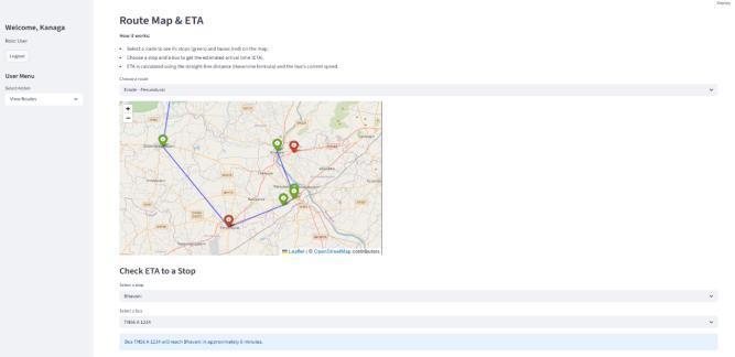
A key component of the CityBus Tracking System is the Estimated Time of Arrival (ETA), which tells passengers whenabusisexpectedtoarriveatadesignatedstop.The bus's real-time GPS location, speed, and distance to the stop whichiscalculatedusingtheHaversineformulafor precisegeographicmeasurement areusedbythesystemto computeETA.Userscangetaccurateandtimelyestimations becausethisdataisupdatedconstantlyasthebustravels. Commuterscanplantheirtripsmoreeffectively,cutdown onwaittimesatbusstops,andmakewell-informedtravel selections by being aware of the anticipated arrival time. ETA also assists administrators in keeping an eye on bus performance and spotting service delays, which enhances overall operational effectiveness and raises passenger happiness.
1.3 GPS-BASED MONITORING
OneofthemainfeaturesoftheCityBusTrackingSystemis GPS-BasedMonitoring,whichusesGlobalPositioningSystem (GPS) technology to continuously track and record bus movements. Every bus has a GPS unit that periodically transmitsitscurrentlatitude,longitude,speed,anddirection toacentraldatabase.Withtheuseofthisdata,thesystemis able to evaluate movement patterns, see real-time bus
Volume: 13 Issue: 03 | Mar 2026 www.irjet.net p-ISSN: 2395-0072
whereabouts on interactive maps, and identify delays or deviations.GPS-basedmonitoringhelpsmanagersmanage fleet operations, optimize routes, and guarantee timely serviceinadditiontoimprovingcommuterconvenienceby givingpreciseandcurrentlocationinformation.Theconcept encourages efficiency, dependability, and transparency in urbanpublictransitbyutilizingGPStechnology.
1.4 PROXIMITY ALERTS & SUBSCRIPTIONS
The CityBus Tracking System's user-focused Proximity Alerts&Subscriptionsfeatureenablescommuterstosignup for their preferred bus stops and get timely alerts when busses are coming. Using real-time GPS data, the system continuously calculates the projected arrival time by trackingthedistancebetweenbussesandsubscribingstops. Analertiscreatedtonotifypassengersinadvancewhena bus enters a specific proximity range or is anticipated to arrive within the user-set notification time. This function improvesconvenience,shortenswaittimes,andfacilitates effectivetripplanningforcommuters.Italsoletscustomers keeptrackondelayedbuses,makingpublictransportation moredependableandresponsive.
2.RELATED WORKS AND LITERATURE SURVEY
Byutilizingsmartphones'built-inGPScapabilities,the2019 studyonGPS-BasedBusTrackingUsingSmartphonesoffers a creative and economical method of monitoring public transit. The technology employs drivers' smartphones to gatherreal-timelocationdata,whichissubsequentlysentto acentralserverviamobileinternetconnectivity,ratherthan dependingonspecializedGPSequipmentinstalledinbuses. Thisgreatlylowersimplementationcostsandincreasesthe system's scalability, particularly in poorer nations where financial limitations are a big issue. A backend server for data processing, a mobile application for drivers, and a mobile or web user interface for passengers make up the usualsystemdesign.Latitudeandlongitudecoordinatesare continuously recorded by the driver's smartphone, which thenperiodicallyupdatestheserver.Passengerscanseethe currentlocationofbuses byprocessingtheseupdatesand seeingthemonamapinterface.Additionally,thesystemcan providecommuterswithhelpfulinformationbyestimating arrival times based on current position and speed. Since cellphonesaremoreaccessibleandrequirelesssetupthan specialist tracking devices, one of the main benefits mentioned in the report is their simplicity of deployment andmaintenance.
Thegoalofthe2021GPS-BasedBusTrackingSystemproject wastousecontinuouslocationmonitoringtoincreasethe effectiveness and dependability of public transportation. Real-time coordinates were recorded by the system using specialized GPS modules mounted in buses. These coordinates were then sent to a centralized server via wireless communication technologies like GSM or GPRS.
Following processing, the gathered data was shown on a web-based interface that administrators and passengers could access. This made it possible for users to estimate arrivaltimesatdifferentlocationsandtrackbusmovements in real time. The study focused on increasing service transparencyandcuttingdownonpassengerwaittimes.It alsoemphasizedhowcrucialcentralizeddatamanagementis for improved operational planning and decision-making. However, compared to smartphones, the system required hardware installation and maintenance, which raised implementationcosts.
In order to improve tracking accuracy and efficiency, the 2023 study presented an Internet of Things (IoT)-based method for bus tracking that integrates several smart devices and communication technologies. The system collectedandsentreal-timebuslocationandmovementdata using sensors, GPS modules, and Bluetooth Low Energy (BLE)devices.ThisdatawassenttocloudplatformsviaIoT gateways,whereitwasprocessedandexamined.Thestudy emphasizedhowIoTsolutionsmayofferbetterconnectivity betweenbusesandcontrolcenters,predictiveinsights,and continuous monitoring. Additionally, improved route planningandperformanceevaluationweremadepossibleby the incorporation of data analytics. Notwithstanding its benefits,thesystemhaddrawbackssuchgreatercomplexity, more expensive setup, and reliance on network infrastructure.
The usage of IoT technology was extended in 2024 by researchonvehiclemonitoringsystems,whichincluded a variety of sensors for tracking the movement and performance of vehicles. To provide thorough vehicle monitoring,thesystemcombinedGPS,temperaturesensors, fuelsensors,andcommunicationmodules.Foranalysisand visualization,thedatagatheredfromthesesensorswassent to a centralized system. The study focused on real-time tracking, better fleet management, and increased safety throughongoingobservation.Additionally,itshowedhow IoTpromotesscalability,enablingthesystemtoeffectively manageseveralvehicles.However,therewereissueswith data security and system upkeep, and the installation necessitatedsubstantialinfrastructure.
Amoresophisticatedsystemthattrackedbuswhereabouts and more accurately anticipated arrival times was implemented in the 2024 study on real-time GPS tracking pairedwithETAprediction.Togatherdatainrealtime,the system made use of embedded devices including microcontrollersandGPSmodulesthatwereputinbuses. Algorithmsthatcomputedspeedanddistancewereusedto processthisdatainordertoforecastarrivaltimesatfuture stops.Inordertoimproveuseraccessibility,theresultswere presentedviaonlineinterfacesandmobileapplications.The studyemphasizedhowcrucialuser-friendlyinterfacesand real-time data processing are to enhancing the passenger experience.Limitationsincludingrelianceonpresentspeed
International Research Journal of Engineering and Technology (IRJET) e-ISSN: 2395-0056
Volume: 13 Issue: 03 | Mar 2026 www.irjet.net p-ISSN: 2395-0072
and lack of interaction with traffic conditions were also covered.
Anopen-accessdatasetwithactualbusGPStrajectorieswas madeavailablebythe2024study,whichwasausefultool forcreatingandevaluatingpredictionmodels.Researchers wereabletoevaluatetravelpatternsanddevelopmachine learningmodelsforETApredictionthankstothedataset's comprehensive information, which included timestamps, locations, and route details. The study highlighted how crucial large-scale, high-quality datasets are to enhancing systemperformanceandpredictionaccuracy.Additionally,it promotedtheapplicationofdata-drivenstrategiesforpublic transportation system optimization. But issues including data cleaning, dealing with missing numbers, and guaranteeingdataconsistencywerealsobroughttolight.
3. PROPOSED METHODOLOGY
TheCityBusTrackingSystemwillbeasophisticatedandallinclusivesolutionforreal-timemonitoringandmanagingof busesinanurbanarea,ultimatelyleadingtogreaterlevelsof efficiencyinurbanpublictransportprocessesandimproved experiencesforthoseusingthemtotravelfromoneplaceto another. The system integrates GPS-enabled buses with a centraldatabaseandweb-baseduserinterfacesfortracking bus locations in real-time, provides estimated times of arrival(ETA)forarrivingateachstopalongbusroutes,and sendsalertnotificationsregardinglatebusesandproximity touser-subscribedbuses.Userswillbeabletoregisterinthe system,subscribetouser-preferredbusstops,andthereby receivetheup-to-dateinformationneededtoplantheirtrips more effectively and reduce their wait at bus stops. The systemprovidesanadministrativedashboardforoperators tomanagebusroutes,buses,busstops,andbusdrivers/bus operators, as well as simulations of real-world locations usingGPSdatafortestingandoptimizingvariousbusroutes in the system's database. By providing real-time location extracts,predictiveETAcalculationsviaHaversinedistance, andmapsofbusstopsusingFolium,theoverallobjectiveof theproposedsystemistomaximizethequalityofeachand every user experience while achieving the best possible operational efficiencies and data-based decision-making opportunitiesbycitytransportationentities.
CommuterscanchecktheEstimatedTimeofArrival(ETA) forbusesatparticularstops,monitorlivebuswhereabouts on an interactive map, and subscribe to notifications for their chosen routes or stations using the system's userfriendly interface. To ensure precise and dynamic predictions, the ETA is computed using the bus's current speedandthedistancebetweenitandthestop.Thesystem also offers proximity-based alerts, which let users know when a bus is getting close to the stop they have chosen within a predetermined window of time. This function greatlyincreasesconvenienceandfacilitatesmoreefficient tripplanning.
Fromanadministrativestandpoint,transportauthoritiescan effectivelymanagebuses,routes,stops,anddriversthanksto the system's extensive dashboard. Administrators can monitor bus movements in real time, add or amend transportation data, and use speed analysis to identify delays. Additionally, the system has a GPS simulation functionthatallowsbusmovementtobetestedandshown withouttheneedforrealhardware.Thisguaranteesthatthe systemcanbesuccessfullyvalidatedandmaintainedpriorto real-worldimplementation.
ETA (Estimated Time of Arrival)
3.1. USER AUTHENTICATION
TheUserAuthenticationModuleisinchargeofcontrolling system security and user access. It guarantees that passwordsaresafelykeptviahashingandenablesnewusers to register by entering their name, email address, and password.Themoduledistinguishesbetweenadministrators andregularusersbyassigningresponsibilitiestousersand supportinglogincapabilities.Regularuserscanaccesslive
Volume: 13 Issue: 03 | Mar 2026 www.irjet.net p-ISSN: 2395-0072
busmonitoring,ETAinformation,andsubscriptionfeatures, but only authorized users can carry out administrative dutiesthankstorole-basedaccess.
3.2 BUS & ROUTE MANAGEMENT
Administratorscaneffectivelycontroleveryfacetofbuses, routes,anddriverswiththismodule.Busescan beadded, updated, or removed by administrators, who can also appoint drivers and assign them to particular routes. In a similarvein,itispossibletodefinenewroutesandstopsand to display current routes on a map for convenient access. This module guarantees efficient operation and efficient planning for urban transportation management by upholdinganorderlystructureofroutes,buses,andstops.
3.3 GPS SIMULATION & TRACKING
Buses are tracked in real time by the GPS Simulation and Tracking Module. Each bus's GPS location, speed, and directionarerecordedinthedatabase.SimulatedGPSdata canbecreatedtoreplicatebusmovementalongroutesfor testinganddemonstrationreasons.Thismodulemakessure that the system always has the most recent bus location information, which is necessary for real-time tracking, calculatingETAs,andcreatingalerts.
3.4
LIVE MAP
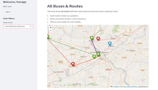
On an interactive city map, the Live Map Module offers a dynamic visual depiction of every bus that is currently in operation.Inadditiontoemployingmarkerstoshoweach bus'slocation,themoduleusescolorcodingtodistinguish between on-time and delayed buses. Pop-ups show additional details like the bus number, current speed, direction,andtimestamp,providinguserswithathorough view of the bus locations in real time and empowering commuterstomakewell-informedtraveldecisions.
3.5 ETA (Estimated Time of Arrival)
TheETAModuledetermineswhenabusislikelytoarriveat acertainstop.Itestimatesjourneytimebycalculatingthe distance between the bus's present location and the stop using the Haversine formula and accounting for the bus's speed. In the event that an ETA cannot be accurately calculated,themoduleoffersstatusmessagesandtakesinto consideration buses that are parked or going slowly. This function shortens wait times at bus stops and aids commutersinmakingeffectivetravelplans.
3.6 ALERTS & SUBSCRIPTION
Withthehelpofthismodule,userscansignupforparticular stopsandgettimelyalertswhenabusisarrivingwithina predeterminedwindowoftime.Itkeepstrackofhowclose busesaretosubscriberstationsandanalyzesrecentspeed data toidentifydelayedbuses.The technologyusesvisual
alertstonotifycommutersofimpendingarrivalsandservice interruptions,improvingconvenienceanddependability.
3.7 ROUTE VIEWER
Usersandadministratorscanseetheentirebusroutelayout onamapusingtheRouteViewerModule.Achosenroute's stopsareplottedtogetherwiththeirorder,andPolylineis usedtoshowtheroutepathforclarity.Administratorscan use this module for planning and verification, and it gives users a thorough overview of routes and aids in their understandingofthebusnetwork.
3.8 DATABASE MANAGEMENT
The system's core is the Database Management Module, which houses all important data, including bus details, routes,stops,drivers,users,GPSlogs,andsubscriptions.It facilitatesCRUD(Create,Read,Update,andDelete)activities forallothermodulesandofferseffectivedataretrieval.This modulemakesitpossibleforfeatureslikelivetracking,ETA computation,alertnotifications,andadministrativeactivities to run smoothly by preserving data integrity and guaranteeingtimelyupdates.
Table -1: INPUTPARAMETERTABLE
Parameter Name Data Type Description
bus_id
INTEGER Uniqueidentifierfor eachbus
latitude FLOAT Currentlatitudeofthe buslocation
longitude FLOAT Currentlongitudeof thebuslocation
speed FLOAT Speedofthebusin km/h
timestamp DATETIM E TimeatwhichGPS dataisrecorded
route_id
stop_id
user_id
notify_before_minu tes
bus_status
INTEGER Identifierforthe assignedroute
INTEGER Identifierforbusstop
INTEGER Uniqueidentifierfor user
INTEGER Timebeforearrivalto triggeralert
STRING Statusofbus (active/delayed/inacti
Volume: 13 Issue: 03 | Mar 2026 www.irjet.net p-ISSN: 2395-0072
4. DATASET DETAILS
The CityBus Tracking System's dataset, which depicts the movement and administration of buses within an urban transportationnetwork,combinesreal-timeandsimulated data.Thesystemcreatessyntheticdatatosimulategenuine bus operations, including routes, stops, and real-time location updates, because real-world GPS data might not alwaysbeaccessible.Featureslikereal-timetracking,ETA computation,andwarningproductionaremadepossiblein largepartbythisdataset.
5. RESULT AND DISCUSSION
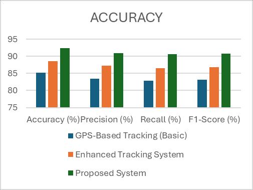
The CityBus Tracking System has been successfully implemented and has been thoroughly evaluated. This systemcanbereliedupon forall ofitsbasicfunctionality, andhasshownreliableperformanceinalloftheseareas.All functionalityiscompletedwithcurrentandhistoricaldata, inreal-time,withGPSintegration,adatabase,andasimple interface presenting the most accurate information regardingbuslocationsandoperationsoftheentirefleet.All of the components of the application worked together as expected,andwereabletosharedatawitheachotherata high degree of accuracy and consistency. The application wasableto respondtouser input ina timelyfashion,and overall system performance was found to be very stable, withnosignificantdelayorerrorduringtesting.Withregard tothereal-timetrackingofbuses,theabilitytoviewlivebus location on an interactive map has proven to be very effective.ByconstantlyupdatingtheGPSdataforeachbus, CityBushasprovideduserswithveryaccurateinformation innearreal-time,whichimprovedtheoverallusabilityofthe application and has improved the transparency of the system.Theuseofmarkersandstatusindicators(ie.on-time anddelayed)tovisuallyrepresentbusesmakesiteasierfor userstointerpretdataandfindtheinformationtheyneed quickly and easily. This has significantly improved the confidencethatusersexperiencewhileusingtheapplication totrackbusesandfindoutwhentheywillarrive.
Bus arrival times at specific stops were accurately and dynamicallyestimatedusingtheETApredictionmodule.The system produced timely predictions that assisted users in makingeffectivetravelplansbyusingreal-timespeeddata andthedistancebetweenthebusandthestop.Theoverall accuracywasenoughfor practical usage,notwithstanding slight variations in ETA caused by changes in speed and simulated data conditions. This module is essential for reducingwaittimesandraisingcommutersatisfaction.
When it came to alerting users about bus delays and closeness,thealertsandsubscriptionmoduleprovedtobe quite effective. Users had the option to subscribe to
particular stops and get notifications when buses arrived within a predetermined window of time. In terms of improvingconvenienceandmakingsurepeopledon'tmiss their busses, this function has proven quite helpful. The delaydetectionsystemalsoassistedinlocatingbusesthat wererunningbelowanticipatedspeedlimits,offeringhelpful informationaboutserviceinterruptions.
Table – 2: COMPARISONTABLE
– 2: ComparisonGraph
6. CONCLUSION
An efficient method for managing and monitoring public transportationinrealtimeiseffectivelydemonstratedbythe CityBus Tracking System. The system gives commuters precise and timely information by combining GPS-based monitoring, ETA prediction, alert notifications, and an interactiveuserinterface.Thisgreatlyreduceswaitingtimes and enhances trip planning. Implementing features like delay detection, proximity alerts, and live map display improves user convenience and guarantees improved communication between passengers and transportation providers.Theadministrativemodulealsomakesitpossible
International Research Journal of Engineering and Technology (IRJET) e-ISSN: 2395-0056
Volume: 13 Issue: 03 | Mar 2026 www.irjet.net p-ISSN: 2395-0072
tohandlebuses,routes,stops,anddriverseffectively,which enhancesoperationalcontrol.Despiteminorlimitationssuch as reliance on simulated data and basic ETA calculation methods, the system achieves its primary objectives and performsreliablyundertestconditions.Theoveralldesignis scalableandcanbefurtherenhancedbyincorporatingrealtimetrafficdata,advancedpredictivealgorithms,andmore robustdatabasesystems.Inconclusion,theCityBusTracking System serves as a comprehensive, user-friendly, and practical approach toward modernizing urban transportation, with strong potential for real-world implementation and future development in smart city environments.
7. FUTURE WORK
Integrationofadditionalmoderntechnologiesandexternal datasets can strengthen the CityBus Tracking System by increased levels of accuracy, scalability and performance. Incorporating real-time traffic and weather data into the ETA prediction module is one of the most important improvements to the existing city bus tracking system becauseitallowsformoreaccurateandconsistentestimates ofwhenabuswillarriveatastop.Furthermore,thesystem couldbemodifiedbyincorporatingmachinelearning(ML) and deep learning (DL) algorithms so that both historical andlivedataareutilizedforimprovedpredictionofdelays andtravelpatterns.Futureadvancementscouldincludethe integration of cloud infrastructure and additional more powerful database technologies such as MySQL or PostgreSQL, in order to support large deployments of the system over multiple users and across large numbers of buses. The introduction of mobile applications for both AndroidandiOSdeviceswouldenhancetheaccessibilityand usabilityforusersofthesystem.Theextensionofexisting functionality with the addition of voice capability, multilingual supportandintegration with digital payment systemswillalsosupportbetteruserexperiences.
8. REFERENCES
[1] Babu, J. P., et al. (2021). GPS Based Bus Tracking System. International Journal of Engineering Research&Technology(IJERT).
[2] Bhavani, S. A., et al. (2022). Bus Tracking System using GPS. International Journal of Computer Applications.
[3] Karunathilake, S., et al. (2023). Bus Tracking and ArrivalPredictionSystem.TechRxivPreprint.
[4] Parveen banu, M., et al. (2024). Real-Time Bus TrackingSystemUsingMobileTechnology.IJER
[5] Gunathilake,C.,&Sharanjah,A.(2024).Real-Time GPS-BasedBusTrackingSystemtoImprovePublic Transportation.
[6] Sharanjah, A. (2024). Real-Time GPS-Based Bus Tracking System with ETA Prediction. Research Proceedings.
[7] Real-Time Bus Arrival Prediction Using Machine LearningandGPS(2025).IJERNDJournal.
[8] Prabha, S., et al. (2025). Smart Transit with GPSBased Real-Time Bus Tracking. ICICC Conference (SSRN).
[9] Tigani,S.(2025).DeepLearning-BasedBusArrival TimeEstimationusingLSTM.MDPI.
[10] Ghazikhani, A., et al. (2024). Data-Driven Travel Time Prediction Using GPS Data. Mathematics Journal(MDPI)