International Research Journal of Engineering and Technology (IRJET) e ISSN: 2395 0056

Volume: 09 Issue: 07 | July 2022 www.irjet.net p ISSN: 2395 0072
International Research Journal of Engineering and Technology (IRJET) e ISSN: 2395 0056
Volume: 09 Issue: 07 | July 2022 www.irjet.net p ISSN: 2395 0072
salunke1 , A.D Thube2
1MTech Student, Department of Civil Engineering, College of Engineering Pune, India 411005, 2Assistant Professor, Department of civil engineering, college of engineering Pune, India 411005, ***
Abstract - A flood occurs when water overflows and submergesordinarilydryterrain. Whenthe flow rateof a riverexceedsthecapacityoftheriverchannel,particularly near bends or meanders, flooding can occur. As a result, settlements are destroyed, human lives are harmed, and infrastructure and public services are lost. It is necessary tomodelfloodplainsinordertodeterminethefloodplain and its extent in advance of taking adequate flood mitigation measures. Decision makers can make better decisions about how to effectively deploy resources to prepareforcatastrophesandimprovethequalityoflifeby assessing the degree of floods and floodwater inundation. The software created models from the HEC RAS simulations are extremely useful in a variety of ways, including determining the extent of floods, associating highfloodlevelswiththedesignandplanningofhydraulic structures, and generating flood plain maps that can be used in town planning or estimating the approximate amountofdamages.Theobjectiveofthisstudywastomap flood inundation areas along the Krishna River. Using the HEC RAS model, ArcGIS for spatial data processing, and Rasmapperforcreatinggeometry,thefloodedareasalong the Krishna River were mapped based on peak flows for different return periods. For 25, 50, and 100 years, the lands around the Krishna River were simulated to be inundated. Proper land use management and tree plantations are crucial in reducing the negative effects of floods, especially in low lying flood prone areas. The findings of this study will assist the responsible agencies in developing plans based on flood plain mapping and hazardlevelsinthearea.
KeyWords: Flood,Inundation,HEC RAS,HEC GeoRas, ArcGIS,Krishna RiverAfloodisanabnormallyhighlevelofflowofwatercaused by run off, which is usually caused by excessive rainfall. The overflowing river exceeds its banks, flooding the surrounding region. Floods cause substantial harm every year, ranging from property damage to economic disruptiontolossoflife.FloodsareamajorthreatinIndia. More than 40 million hectares of the whole geographical area of 329 million hectares is flood prone. Floods are a common occurrence that result in a significant loss of life and damage to property, infrastructure, and public serviceseachyear.
Thehydrographslinkedwithfloodsarecrucialdatainthe developmentofvarioushydrologicschemes.Furthermore, different properties of flood peaks at a specific stream, flood peaks vary every year, and their magnitude is made up of a hydrologic series that allows one to attribute a frequency to a certain magnitude of flood peak. The peak flow that can be expected with a given frequency (for example, once every 100 years) is critical in the construction of any hydraulic systems. In the design of bridges,culverts,canals,anddamspillways,aswellasthe estimation of scour at a hydraulic structure, flood peak is necessary. Flood in a stream has two attributes: (i) magnitude of the peak (highest discharge flows), and (ii) stage of the peak (elevation of the water surface at the maximum flows). The peak flow rate is important to design the (i) spillways of dams and barrages, and (ii) capacities of bridge and waterways. The stage is used for the (i) estimation of the extent of area flooded, (ii) determining the elevation of bridge decks, and (iii) decidingtheminimumelevationforthestructuresbuilton the flood plains. The low lying lands near to the river are known as flood plains. Because these flood plains have become overpopulated as a result of urbanization, the amount of casualties and property destruction has escalated.
After Bangladesh, India is the worst affected country in the world by floods, accounting for one fifth of all flood relateddeathsworldwide.AccordingtotheNationalFlood Commission, floods damage almost 40 million hectares of land in the country each year, with an average of 18.6 million hectares being affected. Annually, around 3.7 million hectares of agricultural land are impacted. MonsoonfloodingistheprimarysourceoffloodsinIndia. During the four month monsoon season (June September), almost 75 percent of India's rainfall is concentrated. During the monsoon, huge river basins in India such as the Ganga, Brahmaputra, Krishna, Godavari, and Cauvery see heavy flooding as their catchments get strong and heavy rainfall. During heavy floods, there is usually no overflow of the banks in the higher sections, when the river travels through steep terrain or an undulating area. Rivers overflow their banks in low lying areas, particularly if the terrain is flat, causing inundation of low lying regions, submerging standing crops and property, and disrupting communications. As a result, importantfloodepisodesinIndiahavebeenincludedhere.
International Research Journal of Engineering and Technology (IRJET) e ISSN: 2395 0056
Volume: 09 Issue: 07 | July 2022 www.irjet.net p ISSN: 2395 0072
In 2004, Bihar had its worst flood in the state whentheGangesRiversurpassedthedangerlevel for the first time at Farakka Barrage, killing 885 humans and 3272 animals and affecting over 21 millionpeoplein20districtsthroughoutthestate. Another flood catastrophe hit the state in 2008, when the Kosi River overflowed, affecting more than2.3millionpeople.
Floods have plagued Assam since 1998. During monsoon seasons, the Brahmaputra River overflows its banks, inflicting massive damage to public property and infrastructure. Assam, for example, was hit by severe flooding in 1998 and 2012.
being Kaziranga National Park, where 13 great Indiarhinosandabout500animalsperished.
The 2013 North India floods produced large landslides and severe rains in nine districts of Uttarakhand, resulting in flash floods across the state.
Thousands of people perished as a result of this disaster, which ruined Lord Shiva'sfamed temple in Kedarnath and a portion of the Char Dhamyatra. It is one of India's most devastating floodsinitshistory.
Floods hit various parts of India in 2005. Gujarat wasfloodedinJuneasaresultofseveremonsoon rainfall.Over250,000peoplehadbeenevacuated and 123 individuals have perished across the state. At least 5,000 people perished in Maharashtra, with Metropolis Mumbai being the most impacted by the rain and the day when the city came to a halt. During the North East monsoon season in Chennai, the maximum rainfall was recorded in November December, and50peoplewerekilledasaresultoffloodsand stampedes.
The Indian floods of 2008 wreaked havoc across the country. Floods struck the western states of Maharashtra and Andhra Pradesh, as well as northernBihar,in2008,asaresultofhighrainfall duringthemonsoonseason.
Flooding hit numerous Indian states in 2009, including Orissa, Kerala, Karnataka, Andhra Pradesh, and the North East. It was one of the worstfloodsintheareain100years,withatleast 299peoplekilledand500,000moredisplaced.
Due to a huge cloud burst and substantial overnight rainfall in the region, Lehin Ladakh, a part of the northernmost Indian state of Jammu and Kashmir, saw flash floods and debris flow in 2010. At least 255 people are said to have perished,withmanymoredisplacedasaresultof the flooding, which wreaked havoc on property andinfrastructure.
In 2012, Himalayan flash floods occurred in the Himalayan states of India at midnight on August 3rd, 2012, as a result of a cloud burst, killing 31 people. Another large flood was caused by high flowsintheBrahmaputraRiveranditstributaries as a result of heavy monsoon rainfall. 124 people were murdered, with the worst affected location
The enormous number of people impacted by flood catastrophes in India shows that a lack of resilience to cope with the occurrence in terms of infrastructure, properties,adaptability,awareness,andplanningmaybea crucialissue.
Identifying the Catchment characteristics
Collecting the Flow data
Performing the Steady State Analysis of the flood in HEC RAS
Identifying the sections with inundation and suggesting a countermeasure
Fig.1Methodologytobefollowedtoperformfloodanalysis
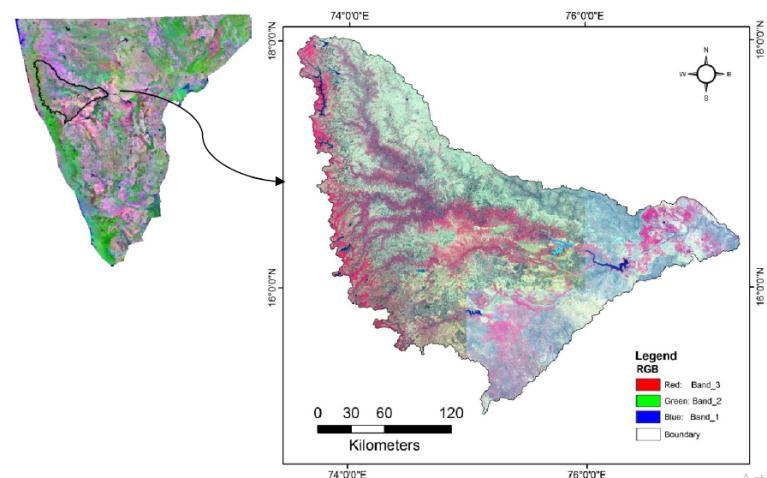
The Krishna basin (Fig. 3.1) includes the Upper Krishna basin, which has an aerial size of 55,537.60 km2. Within the states of Maharashtra and Karnataka, the basin is located between 15°3'20" and 18° 6'20" north latitudes and 73°39'30" and 77°23'10" east longitudes. The basin region is made up of 12 districts from both states, with 9 districts in Karnataka (Bagalkot, Belgaum, Bijapur, Dharwad,Gadag,Gulbarga,Haveri,Koppal,Raichur)and3 districts in Maharashtra (Kolhapur, Sangli, Satara). The basin is generally triangular in shape, with the Western Ghats forming its western boundary, the ridges parted by the Bhima basin forming its northern boundary, and the Tungabhadra basin forming its southern boundary. The main Krishna River begins near Mahabaleswar in Maharashtra's Western Ghats at an elevation of 1360
International Research Journal of Engineering and Technology (IRJET) e ISSN: 2395 0056
metres above sea level and flows for 642.22 kilometers untiljoiningtheBhimaRiveratSangamvillageinGulbarga district.
2.2.1 Terrain Data: To accurately determine the catchment features, a complete terrain model is required. The accuracy of the computed catchment parameters is influenced bytheresolution andclarityofthetopography data. Terrain data may be gathered from a variety of sources, in a variety of forms, and at various levels of detail.Theaccuracyandqualityofthedataaredetermined by the data gathering source used by the user. The catchmentborderiseasilyaccessibleasashapefileonthe Bhuvanwebsite's2D Mapgeoportal'sCatchmenttool.Itis uptotheusertocollectdatafromanysourceandexamine itinGISsoftware.OverGIS basedtools,thiscatchmentfile maybeoverlaidoncontoursandadigitalelevationmodel.
2.2.2 Projection file: Theprojectionfilewasdownloaded from the spatial reference organisation website. The projectionfileisusedtocreateterraininRASMapper.
Table No.1 Datacollectionandsoftwareused.
2.2.3 Discharge data: The discharge data was obtained from the website of the Central Water Commission. The hydro meteorological water year book is used to collect maximum discharge data. The Krishna basin's water year bookfor2019 2020wasretrievedfromtheCentralWater Commission's website. The HEC RAS uses the peak discharge as an input to perform a 1 D steady flow analysis.
2.2.4 Manning's roughness co efficient: Manning's n value is a critical variable. It is very changeable and is affected by a variety of elements such as vegetation, channel irregularities, surface roughness, scour and deposition, channel alignment, channel size and form, temperature, and so on. The manning's roughness coefficientforbankshasbeensetat0.05andforchannels at0.025,basedonapriorresearchinthesamelocation.
2.2.5 HEC RAS: HEC RASsoftwareisusedtoperformone dimensionalsteadyflowanalysis.
2.2.6 Ras Mapper: RAS Mapper tool is used to create a geometryfile,inwhichstreamcentreline,banklines,flow pathlines,andcross sectioncutlinesweredigitized.
2.3.Stream centre line: First and foremost, a stream centreline should be established. The centreline of the stream under investigation is referred to as the stream centreline. With the routine edit tool in Ras Mapper, you may digitise the centreline. The river name and reach names are assigned oncethislayeriscreated,andthefollowingpropertiesare computedusingtherelevantchoices.
Volume: 09 Issue: 07 | July 2022 www.irjet.net p ISSN: 2395 0072 © 2022, IRJET | Impact Factor value: 7.529 | ISO 9001:2008 Certified Journal | Page1446
International Research Journal of Engineering and Technology (IRJET) e ISSN: 2395 0056
Volume: 09 Issue: 07 | July 2022 www.irjet.net p ISSN: 2395 0072
Bank lines: Bank lines are needed to georeference the location of river banks. Bank lines are useful to differentiatetheriverfromthefloodplainareas.
Flow path lines: The direction of water flow is shown by flow path lines. It is used to measure the distance between cross sections in the overbank zones and should bedigitisedinsidethefloodplain.
Cross section cut lines: The DEM's elevation data can be retrieved using cross section cut lines. It must be digitisedperpendiculartotheflowdirection.Itmustcross the river's centre line, as well as its bank and flow route lines.
The water profilesare analysedfrom one cross sectionto the next using an iterative approach known as the standard step method, which involves solving the energy equation. The Energy Equation is represented by the followingequation. Where:
y1, y2:depthofwateratcross sections
Z1,Z2:elevationofthemainchannelinverts
a1,a2:velocityweightingcoefficients v1,v2: averagevelocities
g:gravitationalacceleration he:energyheadlossbetweencrosssections.
The result of 1 D steady flow analysis includes profile output tables for different values of maximum discharges calculated by flood frequency analysis. Using flood frequency analysis maximum discharge values for 25, 50, and 100 year return periods have been calculated. For these values profile output tables are shown below. From tables given below water surface elevation values at each crosssectionscanbeeasilyidentified.
The result of the 1 D steady flow analysis includes floodplain maps for different return periods calculated usingfloodfrequencyanalysis.Floodplainmapsfor25,50, and100 yearreturnperiodisgivenbelow.
3.1.1
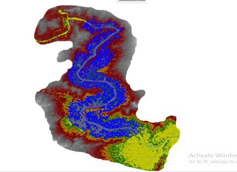
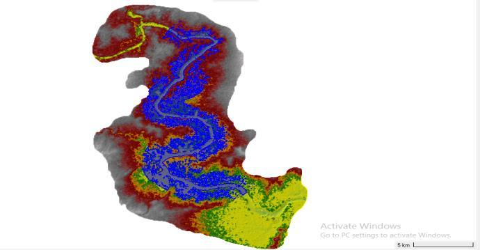
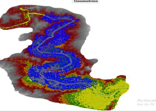
For discharge calculated for 25 year return period using flood frequency analysis, the inundation boundary length is647kmandinundationareais45.01km2
Fig 3 Floodplainmapof25yearsreturnperiod
3.1.2 Floodplain map for 50 years return period
For discharge calculated for 50 year return period using flood frequency analysis, the inundation boundary length is663kmandinundationareais52.21km2 .
Fig .4 Floodplainmapof50yearsreturnperiod.
3.1.3 Floodplain map for 100 years return period
For discharge calculated for 100 year return period using flood frequency analysis, the inundation boundary length is656kmandinundationareais58.42km2
Fig. 5 Floodplainmapof100yearsreturnperiod
2022, IRJET | Impact Factor value: 7.529 | ISO 9001:2008 Certified
International Research Journal of Engineering and Technology (IRJET) e ISSN: 2395 0056
Volume: 09 Issue: 07 | July 2022 www.irjet.net p ISSN: 2395 0072
Returnperiod Inundation area Inundationlength
25 yearreturnperiod 45.01km2 647km 50 yearreturnperiod 52.21km2 663km 100 yearreturnperiod 58.42km2 656km
Table1. Inundationareaandlengthforcorresponding returnperiod
HEC RASalsogivesoutputintheformofgraph.Thisgraph contains cross section and water elevation in that cross section for different time period. Some of the cross sections are given below which are in urgent need of repairbecauseofovertopplingofwaterfrombanks.
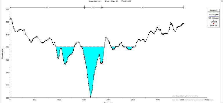
a flood of 100 year return period. From the figure it is observed that the banks are overtopped. The maximum watersurfaceelevationisfoundtobe570.04m.
Fig.5 Waterprofileofcrosssectionatstationnumber 34132.
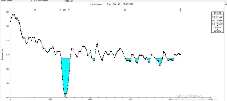
Above graphical representation shows water profile of cross section on Krishna River. The station number of cross section is 34132 that mean it is situated at upstream.Inthis cross section water profile iscreated by a flood of 100 year return period. From the figure it is observed that the banks are overtopped. The maximum watersurfaceelevationisfoundtobe568.88m.
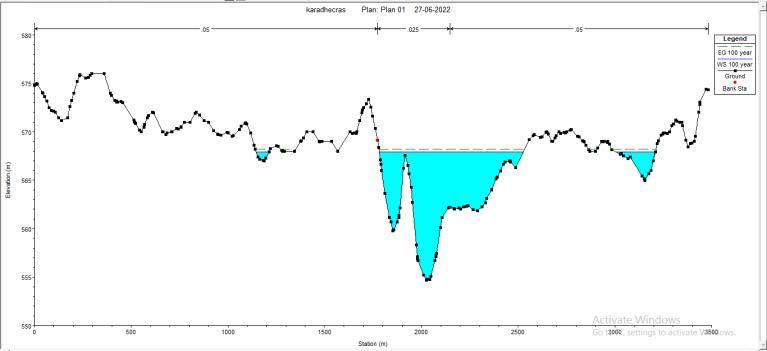
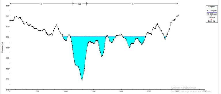
Fig.7 Waterprofileofcrosssectionatstationnumber 30009.
Above graphical representation shows water profile of cross section on Krishna River. The station number of cross section is 30009 that mean it is situated at upstream.Inthis cross section water profile iscreated by a flood of 100 year return period. From the figure it is observed that the banks are overtopped. The maximum watersurfaceelevationisfoundtobe568.57m.
Fig.6 Waterprofileofcrosssectionatstationnumber 32698.
Above graphical representation shows water profile of cross section on Krishna River. The station number of cross section is 32698 that mean it is situated at upstream.Inthis cross section water profile iscreated by
Fig.8 Waterprofileofcrosssectionatstationnumber 27367.
Above graphical representation shows water profile of cross section on Krishna River. The station number of cross section is 27367 that mean it is situated at upstream.Inthis cross section water profile iscreated by a flood of 100 year return period. From the figure it is observed that the banks are overtopped. The maximum watersurfaceelevationisfoundtobe567.91m.
Fromabovecrosssectionsitisevidentthatovertoppingof banksismostlyhappeninginupstreamregionoftheriver. That mean concerned authority should give more attentiontothisareawhiledoingrepairs.
TheHEC RASprogram,developedbytheUSArmy Corps of Engineers at the Hydrologic Engineering Center (HEC), allows one to do one dimensional steady flow calculations. The goal of this project
International Research Journal of Engineering and Technology (IRJET)
e ISSN: 2395 0056
Volume: 09 Issue: 07 | July 2022 www.irjet.net p ISSN: 2395 0072
was to generate a flood inundation map for the 34 kilometer Krishna River stretch. The study's most important findings are summarized as follows:
Flood Inundation Mapping is a key component of nonstructural measures, and data provided by remote sensing and geographic information systems (GIS) can be valuable in hydraulic research.
by deepening and expanding the channel, lowering floodwater levels. Straightening the river channel will helpeliminatingthe rivers' severemeanderingissuesandboostflowvelocity.
The procedures for creating the model may be utilised to re create a functioning model comparabletoitatanylocation.
Levees can be built along river banks in sensitive locations to reduce agricultural losses and flooding damage. The findings of this study may be valuable to flood control agencies. They might take the required steps to protect the research area from flood damage and agricultural losses. These findings may be relevant in the research areaforwatermanagementandallocation.
The flood frequency study yielded 6280, 7410, and 8530 cumec Krishna, for the 25, 50, and 100 yearreturnperiods,respectively
The floodplain maps were made without the need of the pricey ARC GIS and HEC GeoRAS extension, demonstrating the usability of the RAS Mapper tool. In addition, the flood inundation area and length of the inundationbordermaybeeasilydetermined.
For the aforementioned 25, 50, and 100 year return period floods, the flooded areas estimated using HEC RAS were of the order of 45.01, 52.21, and58.42squarekilometres,respectively.
The 1 D steady flow study yields water surface elevation data for each river cross section during floods, as well as minimum channel elevation, energy grade line elevation, energy grade line slope, channel velocity, flow area, top width, and Froudenumber,amongotherthings.
1) E. N. Ali, M. Jaber, (2018) Floodplain Analysis using ArcGIS, HEC GeoRAS and HEC RAS in AttaratUmAl GhudranOilShaleConcessionArea, Jordan. Journal of Civil & Environmental Engineering,Vol.08
The water surface elevation upstream has been foundhigherthandownstreams
2) I. Pathan, P. G. Agnihotri, (2019) A Combined Approach For 1 D Hydrodynamic Flood Modeling ByusingArc Gis,Hec Georas,Hec RasInterface A Case Study On Purna River Of Navsari City, Gujarat. International Journal of Recent Technology and Engineering, Vol.8,Issue1,2277 3878
Floodplain maps have been developed for the 25, 50, and 100 year return periods. After looking at all of the floodplain maps, it was discovered that as the return period value grows, so does the floodinundationarea.
3) Jagadeesh, K. K. Veni, (2021) Flood Plain Modelling of Krishna Lower Basin Using Arcgis, Hec Georas And Hec Ras. IOP Conference Series: MaterialsScienceandEngineering, Vol.1112
Following an examination of floodplain maps and cross section graphs, it was discovered that cross sections on the upstream side were unable to absorb flood, resulting in a greater likelihood of waterovertopping.TheriverstretchnearKrishna nagarinSanglineedstoberepairedimmediately. Itcanbeaccomplishedbyreducingencroachment ontheriver'sfloodplainorbyconstructingalevee alongtheriver'sbank.
4) S. Alaghmand, R. B. Abdullah, I. Abustan, B. Vosoogh, (2010) GIS based River Flood Hazard MappinginUrbanArea(ACaseStudyinKayuAra River Basin, Malaysia). International Journal of EngineeringandTechnology,Vol2,488 500
5) M. S. Khattak, F. Anwar, T. U. Saeed et al. (2016) FloodplainMappingUsingHEC RASandArcGIS:A Case Study of Kabul River. Arabian Journal for ScienceandEngineering,Vol41, 1375 1390
It can be observed that left bank of river is capable of handling the increased discharge but rightbankisinneedofrepair.
The upper Krishna basin requires river channelization.Itimprovesriverchannelcapacity
6) P. Sunilkumar, K. O. Vargheese, (2017) Flood Modelling of Mangalam river using GIS and HEC RAS. International Journal of Advance Research in ScienceandEngineering,Vol.6,159 169
7) S. Yerramilli, (2012) A Hybrid Approach of Integrating HEC RAS and GIS Towards the Identification and Assessment of Flood Risk Vulnerability in the City of Jackson, MS. American Journal of Geographic Information System, Vol. 1, 7 16
8) M. Khan, (2015) Preparation of Flood Inundation Map in Ganga River at Farakka Bridge, Malda, West Bengal, India International Journal of ResearchinGeography(IJRG),Vol.1,Issue1,1 7
9) M. D. Mandviwala, G. S. Joshi, I. Prakash, (2015) Flood Vulnerability Assessment in Lower Tapi River Basin using G.I.S and Remote Sensing. National Conference on Transportation andWaterResourcesEngineering
10) S.Ogras,F.Onen,(2020)FloodAnalysiswithHEC RAS:ACaseStudyofTigrisRiver. AdvancesinCivil Engineering,Vol.2020
11) P. K. Parhi, R. N. Sankhua, G. P. Roy, (2012) Calibration of Channel Roughness for Mahanadi River, (India) Using HEC RAS Model. Journal of WaterResourceandProtection,Vol.4,847 850
12) R.Agrawal,D.G.Regulwar,(2016)FloodAnalysis ofDhudhanaRiverinUpperGodavariBasinUsing HEC RAS. International Journal of Engineering Research Vol.5,IssueSpl1,188 191
13) G. Patel, P. J. Gundaliya, (2016) Floodplain Delineation Using HEC RAS Model A Case Study of Surat City. Open Journal of Modern Hydrology, Vol.6,34 42
14) Haghizadeh, T. Lee, M. Mirzaei, H. Memarian, (2012). Incorporation of GIS Based Program into Hydraulic Model for Water Level Modeling on River Basin. Journal of Water Resource and Protection,Vol.4,25 31
15) H. Pallavi, A. S. Ravikumar, (2021) Analysis of Steady Flow using HEC RAS and GIS Techniques. International Journal of Engineering Research & Technology,IssueSpl2021
16) Issac, P. Raj, R. M. Arer et al. (2019) Steady flow Analysis of Gurupura River Using Hec Ras Software. International Journal of Innovative Research in Applied Sciences and Engineering, Vol. 3(1),432 434
17) K. Adeniran, Y. Ottawale, M. Ogunshina, (2018) MappingandEvaluationofFloodRiskAreasalong Asa River using Remote Sensing and GIS
Techniques. FUOYE Journal of Engineering and Technology,Vol 3(2)
18) Hajibayov,B.D.Ozkul,F.Terzi,(2017)Floodplain Modeling and Mapping Using the Geographical Information Systems (GIS) and Hec RAS/Hec GeoRAS Applications: Case of Edirne, Turkey. Geographical Information Science Research UK, Vol25
19) K. Basnet, D. Acharya, (2019) Flood Analysis at Ramghat, Pokhara, Nepal Using HEC RAS. Nepal Engineers Association, Gandaki Province, Vol.1,41 53
20) Y. İcaga, E. Tas, M. Kilit, (2016) Flood Inundation Mapping by GIS and a Hydraulic Model (HEC RAS):ACaseStudyofAkarcayBolvadinSubbasin, inTurkey. ActaGeobalcanica,Vol.2(2),111 118
21) M. Shrestha, R. Heggen, K. B. Thapa, et al. (2022) FloodRisk andVulnerabilitymappingusngGIS:a Nepalcasestudy
22) H. Shah, A. Alam, M. Bhat, et al. (2016). One Dimensional Steady Flow Analysis Using HEC RAS AcaseofRiverJhelum,JammuandKashmir. EuropeanScientificJournal, Vol.12(32)
23) Government of India Central Water Commission, Water year book, 2020 2021, Krishna basin, Hyderabad http://www.cwc.gov.in/sites/default/files/stage dischargecompressed.pdf
24) India Water Resources Information System, https://indiawris.gov.in/wris/#/
25) Bhuvan: Indian Geo Platform of ISRO, https://bhuvan.nrsc.gov.in/home/index.php
26) ISRO’s Geoportal Bhuvan 2D, https://bhuvan app1.nrsc.gov.in/bhuvan2d/bhuvan/bhuvan2d.p hp
International Research Journal of Engineering and Technology (IRJET) e ISSN: 2395 0056 Volume: 09 Issue: 07 | July 2022 www.irjet.net p ISSN: 2395 0072 © 2022, IRJET | Impact Factor value: 7.529 | ISO 9001:2008 Certified Journal | Page1450