2 minute read
SpatialAspect

from IRJET- Use of Urbanization Index Model by using Multi - Dimensional Aspects for Assessing Urbani

Volume: 08 Issue: 08 | Aug 2021 www.irjet.net p-ISSN: 2395-0072
rurality in arrange to draw an agent test for the overview. It utilize freely available spatial input information such as handset or outstanding disciple pictures given by USGS and open source GIS computer program such as QGIS. The file was created essentially to “Index of relative rurality (IIR) as an unweighted normal of two normalized input factors and offers the comparative properties of the last mentioned.
Advertisement
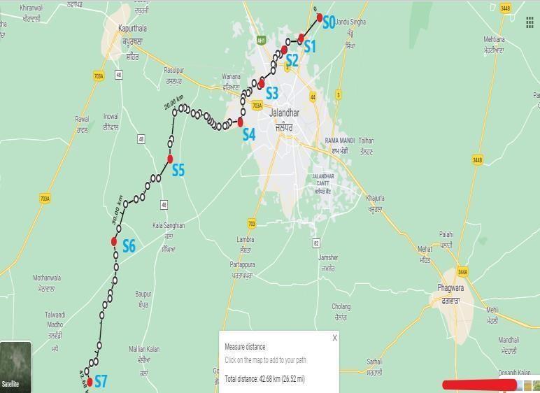
Therefore, there requires a re-examine the urbanization record in its multi-dimensional concept, moving a step ahead of the statistic criteria to have a practical record. In this study the nearby cities of Kala Sanghian drain of Jalandhar, Punjab (India) is taken as a study area. There are total seven different locations which are chosen which surrounds the points marked on drain (fig 1.) i.e., S0 is near Dhogri road, S1 location is adjoining Nurpur, S2 location is near Transport Nagar, S3 location is near DAV College, S4 location is in Wariana, S5 location is front side of Ibban, S6 location is nearby Manan, S7 location is near Khanpur Dhadda have been chosen for deciding the Urbanization index along the Kala Sanghian Drain. The nine urbanization parameters has been selected i.e., Populace size, Population density, Education facilities, Health services, Industries, Electricity facilities, type of roofing material, assests and % of Built-up area to analyze in this investigation to choose the urbanization level of this load of areas which can additionally assist with recognizing the reason for dissolution of water of the drain
2 Material & Method Study Area
In this study, an endeavor has been made to create Urbanization index model. The developed model is then applied to different nearby locations of Kala Sanghian Drain in the state of Punjab: S0 is near Dhogri road, S1 location is adjoining Nurpur, S2 location is near Transport Nagar, S3 location is near DAV College, S4 location is in Wariana, S5 location is front side of Ibban, S6 location is nearby Manan, S7 locationisnearKhanpurDhaddatoestimatethelevel of Urbanization in these regions. The model developedis thenvalidatedusingtheurbanization level given by Census of India, 2011. Here fig 1 shows all the marked pointson the drain and the surrounded area of these points about4to5km’seacharefurther investigated tocalculateurbanizationindex.
Fig 1. Points marked (S0, S1, S2, S3, S4, S5, S6, S7) on the Kala Sanghian drain on Jalandhar map
(https://www.google.com/maps/place/Jalandhar,P unjab/@31.3223787,75.5033788,12z)
Urbanization index
In the present study, four multi-dimensional aspects hasbeendevelopedtheurbanizationindex,considered for selecting the marker parameters for the urbanization:
1.Demographicaspect
2. Infrastructuraldevelopmentaspect
3.SpatialAspect
4.Economicdevelopmentaspect