International Research Journal of Engineering and Technology (IRJET)
e-ISSN: 2395-0056
Volume: 06 Issue: 03 | Mar 2019
p-ISSN: 2395-0072
www.irjet.net
Use Geotechnical to Analyze Agricultural Use Changes to Support Urban Planning Policies Shadi Z. M. Kuhail skouhail@ucas.edu.ps Master of Geography and GIS Coordinator of GIS Specialization Lecturer in Information Technology Department University College of Applied Sciences - Gaza. Palestine
------------------------------------------------------------------------------------------------------------------------------------------
2. Can maps be provided showing the distribution of current and future agricultural land?
Abstract:The study aimed at analyzing satellite data to
track the change in agricultural use in Gaza governorates by using geographic information systems and remote sensing techniques, in addition to determining the land plots that are considered the most appropriate in directing urbanization away from the waste of agricultural lands. The study also showed an overview of information systems Geographic and Remote Sensing As an optimal technical technique used in analysis, the study showed that the use of remote sensing technology cannot be dispensed through the analysis of spatial visualization to calculate the area of agricultural land in ancient times Recently, the study showed that the use of cartographic modeling to arrive at the identification of appropriate vouchers for agricultural activities is more efficient than the methods used in local institutions.
3. How geotechnical techniques are used to analyze satellite data?
1.2 Objectives
1. The use of GIS technology and remote sensing in the analysis of satellite data 2. Study of the change in the area of agricultural land from 1975 to 2018 using remote sensing. 3. Expected calculation of agricultural land in 2030.
2. Method of analysis
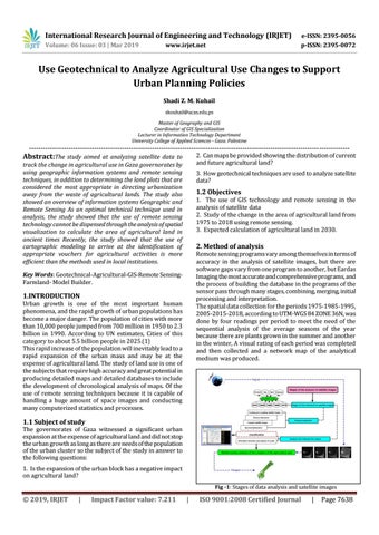
Remote sensing programs vary among themselves in terms of accuracy in the analysis of satellite images, but there are software gaps vary from one program to another, but Eardas Imaging the most accurate and comprehensive programs, and the process of building the database in the programs of the sensor pass through many stages, combining, merging, initial processing and interpretation. The spatial data collection for the periods 1975-1985-1995, 2005-2015-2018, according to UTM-WGS 84 ZONE 36N, was done by four readings per period to meet the need of the sequential analysis of the average seasons of the year because there are plants grown in the summer and another in the winter, A visual rating of each period was completed and then collected and a network map of the analytical medium was produced.
Key Words: Geotechnical-Agricultural-GIS-Remote SensingFarmland- Model Builder.
1.INTRODUCTION
Urban growth is one of the most important human phenomena, and the rapid growth of urban populations has become a major danger. The population of cities with more than 10,000 people jumped from 700 million in 1950 to 2.3 billion in 1990. According to UN estimates, Cities of this category to about 5.5 billion people in 2025.(1) This rapid increase of the population will inevitably lead to a rapid expansion of the urban mass and may be at the expense of agricultural land. The study of land use is one of the subjects that require high accuracy and great potential in producing detailed maps and detailed databases to include the development of chronological analysis of maps. Of the use of remote sensing techniques because it is capable of handling a huge amount of space images and conducting many computerized statistics and processes.
1.1 Subject of study
The governorates of Gaza witnessed a significant urban expansion at the expense of agricultural land and did not stop the urban growth as long as there are needs of the population of the urban cluster so the subject of the study in answer to the following questions: 1. Is the expansion of the urban block has a negative impact on agricultural land? Fig -1: Stages of data analysis and satellite images
Š 2019, IRJET
|
Impact Factor value: 7.211
|
ISO 9001:2008 Certified Journal
|
Page 7638