International Research Journal of Engineering and Technology (IRJET)
e-ISSN: 2395-0056
Volume: 06 Issue: 03 | Mar 2019
p-ISSN: 2395-0072
www.irjet.net
Autonomous Operation and Controlling of Unmanned Ariel Vehicle (UAV) using Internet Ghanshyam Patankar1, Sandesh Ramdasi 2, Ketan Shukla 3, Prince Yadav4 1,2,3,4Dept. of EXTC Engineering, Rajiv Gandhi Inst. of Technology, Mumbai, Maharashtra ---------------------------------------------------------------------***----------------------------------------------------------------------
Abstract - Nowadays, Unmanned Aerial Vehicle (UAV) is an important technology for military and security application. Various missions can be done using UAVs such as surveillance in unknown areas, forestry conservation, disaster affected areas and spying enemy territory. Application which is developed in this research has a purpose to simulate condition in war zone for spying the enemy. This system consist of a multipurpose drone with features like HD video recording camera, night vision, drop facility (used for delivering food packets and health kits to soldiers on war field), Radar, water landing capability, Integrated GPS module for long distance controlling and data transmitting. It also includes computer software for drone and controller interface. Through utilizing modern telecommunication networks, we present a UAV capable of intelligent remote waypoint navigation. Through the use of a web interface employing mapping software, users are able to specify remote waypoints for the UAV to navigate. The UAV maintains an internet connection through 4G LTE (or 3G if necessary), allowing monitoring and control within regions of no Wi-Fi or radio reception. The UAV is controlled through a Raspberry Pi, employing GPS and 4G modules, along with a suite of sensors including a 10 megapixel camera. Utilizing various image processing algorithms for object detection, the UAV can coordinate flight patterns to perform tasks such as object tracking and surveillance. Through utilizing GPS in tandem, the UAV can perform intelligent searching operations.
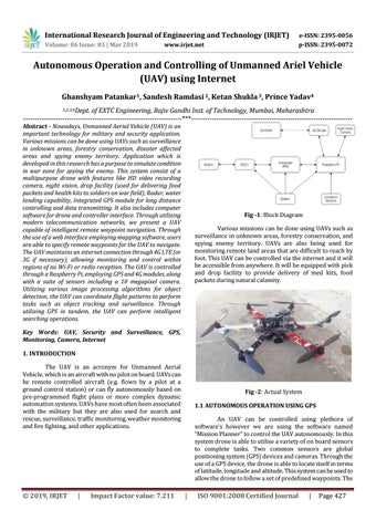
Fig -1: Block Diagram Various missions can be done using UAVs such as surveillance in unknown areas, forestry conservation, and spying enemy territory. UAVs are also being used for monitoring remote land areas that are difficult to reach by foot. This UAV can be controlled via the internet and it will be accessible from anywhere. It will be equipped with pick and drop facility to provide delivery of med kits, food packets during natural calamity.
Key Words: UAV, Security and Surveillance, GPS, Monitoring, Camera, Internet 1. INTRODUCTION The UAV is an acronym for Unmanned Aerial Vehicle, which is an aircraft with no pilot on board. UAVs can be remote controlled aircraft (e.g. flown by a pilot at a ground control station) or can fly autonomously based on pre-programmed flight plans or more complex dynamic automation systems. UAVs have most often been associated with the military but they are also used for search and rescue, surveillance, traffic monitoring, weather monitoring and fire fighting, and other applications.
© 2019, IRJET
|
Impact Factor value: 7.211
Fig -2: Actual System 1.1 AUTONOMOUS OPERATION USING GPS An UAV can be controlled using plethora of software’s however we are using the software named “Mission Planner” to control the UAV autonomously. In this system drone is able to utilise a variety of on board sensors to complete tasks. Two common sensors are global positioning system (GPS) devices and cameras. Through the use of a GPS device, the drone is able to locate itself in terms of latitude, longitude and altitude. This system can be used to allow the drone to follow a set of predefined waypoints. The
|
ISO 9001:2008 Certified Journal
|
Page 427