
International Research Journal of Engineering and Technology (IRJET) e-ISSN: 2395-0056
Volume: 13 Issue: 02 | Feb 2026 www.irjet.net p-ISSN: 2395-0072
International Research Journal of Engineering and Technology (IRJET) e-ISSN: 2395-0056
Volume: 13 Issue: 02 | Feb 2026 www.irjet.net p-ISSN: 2395-0072
OmkarPanditRathod1,NileshRameshVetal2,PremSandipNaik3,KartikSupadu Jadhav4 , Prof. Anil Naik5 , Prof.S.M.Shaikh6
1,2,3,4 (Students, Department of Computer Engineering), S.Y.P Shreeyash College Of Engineeringand Technology (Polytechnic), Chh.Sambhajinagar , 5(Hod, Dept. Of Computer Engineering), 6(Teacher ,Department Of Computer Engineering) S.Y.P Shreeyash College Of Engineeringand Technology (Polytechnic), Chh.Sambhajinagar , India ***
Abstract - This study examines recent developments in GPS- and GSM-based tracking technologies designed to enable real-time location monitoring. The Global Positioning System (GPS) provides precise geographic positioning through satellite signals, while the Global System for Mobile Communications (GSM) facilitates reliable wireless data transmission across cellular networks. The integration of these two technologies forms the foundation of modern personal tracking systems.
In the proposed framework, geographic coordinates acquired from the GPS receiver are transmitted to a remote tracking server using a GSM/GPRS communication module. Data transfer can be performed through Short Message Service (SMS) or General Packet Radio Service (GPRS), depending on network availability and system requirements. The receiving server processes incoming location data and stores it within a centralized database to enable continuous monitoring and historical record maintenance.
The hardware architecture consists of a compact embedded single-board system incorporating GPS and GSM modules, managed by an ARM-based microcontroller. The portable device is designed to be carried by the user, allowing uninterrupted tracking of movement. Whenever a change in location is detected, updated coordinates are automatically transmitted to the monitoring server to ensure timely updates.
A dedicated software application is implemented on the server side to receive, decode, analyze, and archive incoming data packets. By combining satellite-based positioning with cellular communication technology, the system achieves accurate location tracking and near real-time data updates.
Recent advancements in GPS-based tracking systems have focused on improving positional efficiency, power optimization, and overall system reliability. This paper reviews contemporary research contributions and technological enhancements in the domain of personal tracking and monitoring systems.
Key Words: GPS, GSM, Real-Time Tracking, Location Monitoring, Embedded System, ARM Processor, GPRS Communication, SMS Transmission, Personal Safety System, Tracking Server, Wireless Communication, IoT-Based Monitoring
Inrecentyears,ensuringpersonalsecurityhasbecomeincreasinglyimportant,particularlyforwomenandyounggirls.Rising concernsrelatedtoharassment,abduction,andunsafetravelenvironmentshaveemphasizedthenecessityfordependable, real-timesafetymechanisms.Technologicaladvancementsoffereffectivesolutionstothesechallengesthroughintelligent monitoringandrapidemergencyresponsesystems.Amongthese,trackingsystemsthatintegratesatellitepositioningand cellularcommunicationtechnologiespresentapracticalandscalableapproachtoenhancingpersonalsafety.
TheGlobalPositioningSystem(GPS)enablesprecisegeographiclocationidentificationthroughsatellite-basedsignals,while the Global System for Mobile Communications (GSM) provides a robust platform for wireless data transmission. The combinationofthesetechnologiesallowsthedevelopmentofareal-timetrackingsystemcapableofcontinuouslymonitoringa user’slocationandtransmittingalertsduringemergencysituations.
TheproposedsystemisstructuredaroundacompactembeddeddeviceintegratingGPSandGSMmodules,managedbya microcontrollerorARM-basedprocessor.Designedforportability,thedevicemaybeimplementedasawearableaccessory, identificationcard,orsmallhandheldunit.Inemergencyscenarios,activationofanSOSmechanismtriggerstheautomatic transmission of location coordinates via SMS or GPRS to predefined contacts or a centralized monitoring server. This functionalityfacilitatesimmediatecommunication,accuratepositiontracking,andfasterresponsetimes.
International Research Journal of Engineering and Technology (IRJET) e-ISSN: 2395-0056
Volume: 13 Issue: 02 | Feb 2026 www.irjet.net p-ISSN: 2395-0072
Theprimaryobjectiveofthisresearchistodesignandevaluateacost-effective,reliable,anduser-friendlytrackingsolution thatstrengthenspersonalsecurity.Bydeliveringreal-timelocationupdatesandemergencynotifications,thesystemenhances situationalawarenessforguardiansandsupportnetworkswhileprovidinguserswithanaccessiblesafetytool.Theintegration of embedded systems, satellite navigation, and wireless communication technologies ensures practical deployment and adaptabilityinreal-worldenvironments.Theproposedframeworkemphasizesimprovedemergencyresponseefficiencyand effectiveutilizationofexistingcommunicationinfrastructure.
Atrackingsystemisdevelopedtoidentifyandcontinuouslymonitorthelocationofapersonorobject,regardlessofwhetherit isstationaryormoving.Suchsystemsacquirepositionaldataandtransmitittoacentralizedmonitoringunitforsupervision, analysis,andmanagement.Trackingtechnologiesarecurrentlyimplementedacrossmultipledomains,includingvehiclefleet management,railwayoperations,logisticscoordination,andpersonalsecurityapplications.
Amongtheseapplications,vehicletrackingsystemsrepresentoneofthemostwidespreaduses.ByintegratingtheGlobal PositioningSystem(GPS)forlocationdetectionandtheGlobalSystemforMobileCommunications(GSM)forwirelessdata transmission, these systems provide accurate and real-time information regarding vehicle position. The location data is periodically updated and communicated to a control center, enabling continuous supervision and improved operational efficiency.
Railwaytrackingsystemshavesimilarlybecomeessentialforenhancingpassengersafetyandoptimizingsignalingandtraffic management. Contemporary train monitoring solutions incorporate satellite-based positioning, onboard communication modules, and wireless networking technologies to determine precise train locations. The acquired data is transmitted to railwaytrafficcontrolcenters,supportingrouteplanning,collisionprevention,andschedulingefficiency.
AGPS/GSM-basedtrackingframework operatesbyutilizingsatellitesignalstocompute geographiccoordinates andtime parameters.TheGPSreceiverdeterminestheexactposition,whiletheGSMnetworkfacilitatestransmissionofthisinformation toa remoteserverormonitoringstation.Suchsystemsarerecognizedfortheiraffordability,reliability,andcapabilityto delivernearreal-timeupdates.
Typically, a GPS/GSM tracking architecture consists of two principal components:
1. MobileUnit:Aportabledeviceinstalledonorcarriedbytheuserorobject,integratingGPSandGSMmodulesalong withamicrocontrollerorembeddedprocessor.
2. ControlStation:Acentralizedserverorsoftwareplatformresponsibleforreceiving,processing,storing,anddisplaying transmittedlocationdata.
ThemobileunitcollectspositionalinformationandtransmitsitviaSMSorGPRStothecontrolstation.Server-sidesoftware thendecodes,analyzes,andvisualizesthereceiveddataformonitoringanddecision-makingpurposes.GSM-basedwireless communicationensuresextensivenetworkcoverageanddependabledataexchange.
SMS-basedcommunicationremainswidelyadoptedduetoitssimplicity,lowoperationalcost,andcompatibilitywithexisting mobileserviceinfrastructures.Itprovidesareliablemechanismfortransmittinglocationdetails,particularlyinregionswith limitedinternetconnectivity.Incontrast,GPRS-basedcommunicationenablescontinuousdatastreaming,makingitsuitablefor livetrackingapplications.
RecentprogressinembeddedsystemdesignhasfacilitatedtheintegrationofGPSandGSMmodulesintocompact,energyefficient devices. Additionally, optimization techniques have been introduced to minimize communication costs while maintaininghightrackingaccuracy.Overall,theconvergenceofsatellitepositioningandcellularcommunicationtechnologies offersarobustandefficienttrackingsolution.Thesesystemsdeliverpreciselocationmonitoring,reliableconnectivity,and cost-effectivedeployment,makingthemhighlyappropriateforpersonalsecurityapplications,includingGPS-basedsafety systemsdesignedtoenhanceprotectionandrapidemergencyresponse.
Atrackingsystemisatechnologicalframeworkdesignedtodetermineandcontinuouslymonitorthereal-timelocationofa personorobject.Itoperatesbyacquiringpositionaldataandtransmittingittoanauthorizedmonitoringentityforobservation,
International Research Journal of Engineering and Technology (IRJET) e-ISSN: 2395-0056
Volume: 13 Issue: 02 | Feb 2026 www.irjet.net p-ISSN: 2395-0072
analysis,andresponse.Suchsystemsarecapableoffunctioninginbothstatic(fixed)anddynamic(in-motion)conditions, ensuringuninterruptedsupervisionacrossvaryingoperationalenvironments.
TheproposedGirls’SafetyTrackingSystemisdevelopedthroughtheintegrationoftheGlobalPositioningSystem(GPS)andthe GlobalSystemforMobileCommunications(GSM).TheGPSmodulereceivessatellitesignalstocomputeprecisegeographic coordinates,includinglatitudeandlongitude.ThesecoordinatesaresubsequentlytransmittedthroughtheGSMnetworkusing ShortMessageService(SMS)orGeneralPacketRadioService(GPRS)topredefinedcontactsoracentralizedtrackingserver.
Thesystemarchitecturecomprisestwoprimarycomponents:
1. Mobile Unit (Tracking Device):
IntegratedGPSmoduleforaccuratelocationacquisition
GSM/GPRSmoduleforwirelesscommunication
MicrocontrollerorARM-basedprocessorfordataprocessingandsystemcontrol
EmergencySOSbuttonforimmediatealertactivation
2. Monitoring Unit (Base Station/Server):
Receivestransmittedlocationdata
Storesinformationinastructureddatabase
Displaysreal-timepositionthroughaGeographicInformationSystem(GIS)ormap-basedinterface
Generatesnotificationsforguardiansorauthorizedauthorities
The tracking device periodically updates the user’s position as movement occurs, ensuring continuous monitoring. In emergency situations, activation of the SOS function triggers an immediate alert message containing the user’s current coordinatesandtimestamp.Beyondreal-timetracking,thesystemmaintainshistoricalrecords,includingpreviouslyvisited locations,travelroutes,anddurationofstayatspecificpoints.
UtilizationofGSMnetworksprovidesextensivecommunicationcoverageanddependabledatatransfer,whileGPStechnology ensures high positional accuracy. SMS-based transmission offers a cost-effective and accessible communication method, particularlyinregionswithlimitedinternetconnectivity,whereasGPRSsupportscontinuouslivetrackingapplications.
Overall, the proposed tracking system strengthens personal security by enabling real-time location monitoring, rapid emergencyresponse,andsystematicdatamanagementwithinareliableandscalabletechnologicalframework.
TheGlobalPositioningSystem(GPS)isasatellite-basednavigationinfrastructurethatprovidespreciselocationandtiming information anywhere on the Earth’s surface. Initially developed for defense applications, GPS has since become widely adoptedinciviliandomains,includingnavigation,cartography,surveying,andtrackingsystems.Itsglobalaccessibilityandhigh accuracymakeitafundamentalcomponentofmodernpositioningtechnologies.
GPSoperatesthroughaconstellationofsatellitesorbitingtheEarth,eachcontinuouslytransmittingradiosignalscontaining orbital parametersand precisetime information.A GPS receiver,such asthe moduleintegratedinto the proposedsafety trackingdevice,acquiressignalsfrommultiplesatellites typicallyaminimumoffour todetermineitsexactgeographic position.Thispositioningprocessisbasedontrilateration,amathematicalmethodusedtocalculatecoordinatesbymeasuring distancesfromknownreferencepoints.
Working Principle of GPS
1. Satellite Signal Transmission:GPS satellites broadcast radio signals that include their current position and synchronizedtimedata.
2. Signal Reception:TheGPSreceiverembeddedwithinthetrackingdevicecapturessignalsfrommultiplesatellites simultaneously.
3. Distance Estimation:Thereceivercalculatesthedistancetoeachsatellitebymeasuringthetimedelaybetweensignal transmissionandreception.
4. Position Calculation:Usingtrilateration,thereceiverdeterminestheuser’spreciselatitude,longitude,andaltitude.
International Research Journal of Engineering and Technology (IRJET) e-ISSN: 2395-0056
Volume: 13 Issue: 02 | Feb 2026 www.irjet.net p-ISSN: 2395-0072
5. Time Synchronization:GPSalsoprovidesaccuratetiminginformation,whichisvaluableforrecordingmovement patternsandeventtimestamps.
Key Features of GPS Technology
Real-timegeographicpositioning
Highaccuracy(generallywithin5–10metersunderstandardconditions)
Globalcoverageacrossland,sea,andairenvironments
Continuous24/7operationinmostweatherconditions
Nosubscriptioncostforaccessingsatellitesignals
Role of GPS in the Proposed Safety System
WithintheGirls’SafetyTrackingSystem,theGPSmoduleperformsseveralessentialfunctions:
Determiningtheuser’sexactgeographiccoordinates
Providingperiodiclocationupdatesforcontinuousmonitoring
Generatingtime-stampedmovementrecords
Supportingaccuratelocationidentificationduringemergencies
ThepositionaldataacquiredfromsatellitesistransmittedviatheGlobalSystemforMobileCommunications(GSM)networkto a monitoring server or designated emergency contacts. This integration enables real-time access to the user’s location wheneverrequired.
Advantages of GPS in Safety Applications
Precisetrackingduringemergencysituations
Rapididentificationofcurrentlocation
Capabilitytomonitorroutesandmaintainmovementhistory
Cost-effectiveandreliablepositioningsolution
Overall,GPStechnologyformsthecorepositioningmechanismoftheproposedsafetyframework,ensuringdependableand accuratelocationtrackingforenhancedpersonalsecurity.
TheGlobalSystemforMobileCommunications(GSM)isawidelyadopteddigitalcellularcommunicationstandardthatenables wirelessvoiceanddatatransmission.Itprovidesreliableandextensivenetworkcoverage,makingitsuitableforlong-distance communicationinmobileandembeddedapplications.Duetoitsstabilityandcost-effectiveness,GSMtechnologyisfrequently integratedintotrackingsystemsfortransmittinglocationinformationandemergencyalerts
GSMoperatesthroughanetworkofgeographicallydistributedbasetransceiverstations(celltowers)thatcommunicatewith mobiledevicesviaradiofrequencysignals.EachdeviceconnectedtothenetworkcontainsaSubscriberIdentityModule(SIM) card,whichauthenticatestheuserandfacilitatesaccesstonetworkservicessuchasvoicecalls,ShortMessageService(SMS), andpacket-baseddataservicesincludingGeneralPacketRadioService(GPRS).
Working Principle of GSM in Tracking Systems
1. SignalTransmission:
TheGSMmoduleembeddedinthetrackingdevicetransmitscollecteddata suchasgeographiccoordinatesobtainedfrom theGlobalPositioningSystem(GPS) tothenearestcellularbasestation.
2. NetworkRouting:
Thecellularinfrastructureroutesthetransmitteddatathroughthecorenetworktothedesignatedrecipient,whichmaybe amobilephone,monitoringserver,orweb-basedapplication.
3. DataReceptionandProcessing:
Thereceivingdeviceorserverdecodesandprocessesthetransmittedinformation,enablingvisualizationoftheuser’s locationandrelateddetails.
International Research Journal of Engineering and Technology (IRJET) e-ISSN: 2395-0056
Volume: 13 Issue: 02 | Feb 2026 www.irjet.net p-ISSN: 2395-0072
Short Message Service (SMS):SMS is commonly used to transmit location coordinates directly to predefined emergencycontacts.Itisadependablecommunicationmethodandremainsfunctionaleveninregionswithlimited internetconnectivity.
2. General Packet Radio Service (GPRS):GPRSsupportspacket-switcheddatatransmission,allowingcontinuousor periodicupdatesoflocationinformationtoacentralizedserverormobileapplicationforreal-timetracking.
WithintheGirls’SafetyTrackingSystem,GSMtechnologyservesastheprimarycommunicationmedium.AftertheGPSmodule determinestheuser’sgeographicposition,theGSMmoduletransmitsthisinformationtopredefinedemergencycontacts,a centralizedmonitoringstation,oradedicatedmobileapplicationforlivetracking.
Inemergencysituations,activationoftheSOSmechanismtriggerstheimmediatetransmissionofanalertmessagecontaining theuser’scurrentcoordinatesandtimestamp.Thisrapidcommunicationcapabilityensurestimelynotificationandfacilitates promptresponseduringcriticalevents.
Overall,GSMtechnologycomplementssatellite-basedpositioningbyprovidingdependable,wide-areacommunication,thereby forminganessentialcomponentoftheproposedreal-timesafetyandtrackingframework.
TheSIM300isacompactGSM/GPRScommunicationmodulewidelyusedinembeddedsystemstoenablemobileconnectivity. ItallowsdevicestosendandreceiveSMS,makevoicecalls,andtransmitdataoverGSMnetworks.Itssmallformfactor,low power requirements, and simple interfacing make it a preferred choice for GPS/GSM-based tracking systems and other portableapplications.
Overview and Key Features of
Tri-bandGSMsupport(900/1800/1900MHz)
SMScapability(supportsbothtextandPDUmodes)
GPRS-baseddatatransmission
Lowpowerconsumptionforextendeduse
Compactsizesuitableforembeddedapplications
ATcommand-basedcontrolforeasyprogramming
SIMcardinterfacesupport
Working Principle
TheSIM300modulecommunicateswitha microcontrollerorembeddedprocessor(e.g.,Arduino orARM-basedsystems) throughserialcommunication(UART).ItiscontrolledusingstandardATcommandstoperformoperationssuchasnetwork registration,datatransmission,andSMSmessaging.
1. Initialization:
ThemicrocontrollersendsATcommandstoconfigureandinitializetheSIM300module.
2. NetworkRegistration:
ThemoduleconnectstothenearestGSMcellulartowerusingavalidSIMcardtoestablishnetworkconnectivity.
3. Data Transmission:
o GPScoordinatescanbesentviaSMStopredefinednumbers.
o DatacanalsobetransmittedtoaremoteserverusingGPRSforreal-timetracking.
4. AlertFunction:
WhentheSOSbuttononthedeviceisactivated,themicrocontrollerinstructstheSIM300moduletoimmediatelysend anemergencymessagecontainingtheuser’scurrentlocation.
International Research Journal of Engineering and Technology (IRJET) e-ISSN: 2395-0056
Volume: 13 Issue: 02 | Feb 2026 www.irjet.net p-ISSN: 2395-0072
IntheGPS/GSM-basedsafetytrackingsystem,theSIM300moduleplaysacriticalroleincommunication:
TheGPSmodulecollectslatitudeandlongitudedataoftheuser.
Themicrocontrollerprocessesthepositionalinformation.
TheSIM300moduletransmitstheprocesseddatathroughtheGSMnetwork.
EmergencycontactsorguardiansreceiveinstantSMSalertscontainingtheuser’slocation,ensuringprompt responseincaseofemergencies.
By integrating GPS positioning with SIM300-based GSM communication, the system provides reliable, real-time location trackingandarapidalertmechanism,makingiteffectiveforpersonalsafetyapplications.
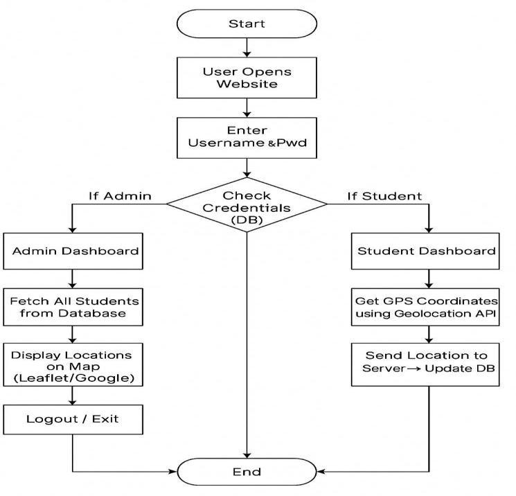
The proposed solution integrates mobile computing with Global Positioning System (GPS), Global System for Mobile Communications (GSM), General Packet Radio Service (GPRS), and Geographic Information System (GIS) technologies to developanefficientpersonaltrackingandsafetymanagementsystem.Bycombiningsatellite-basedpositioningwithwireless communicationnetworks,thesystemprovidesaccuratelocationmonitoringandsupportsreal-timedatatransmission.
The system primarily relies on two core technologies: GPS for precise location detection and GPRS for wireless data communication.TheGPSmodulecalculatestheuser’sgeographiccoordinates(latitudeandlongitude)usingsatellitesignals. ThesecoordinatesarethentransmittedviaaGSM/GPRS-enabledmobilenetworktoacentralizedmonitoringserverorbase station.
Thetrackingdevicecaneitherbeadedicatedembeddedunitorintegratedintoamobilephone.Manymodernsmartphones alreadyfeaturebuilt-inGPSreceiversandGSMtransmitters,makingthemsuitableforreal-timetrackingonland,sea,orair. These devices can continuously transmit positioning data to authorized contacts or monitoring servers through mobile networks.
EachmobiledevicepossessesauniqueInternationalMobileEquipmentIdentity(IMEI)number,whichservesasaunique identifier withinthetrackingsystem.Whenlocationdata istransmitted,theIMEInumbercanbeincludedalongsideGPS coordinatestoensurethatthedevice andthereforetheuser isuniquelyidentified.
International Research Journal of Engineering and Technology (IRJET) e-ISSN: 2395-0056
Volume: 13 Issue: 02 | Feb 2026 www.irjet.net p-ISSN: 2395-0072
The received data is securely stored at the base station for monitoring, analysis, and historical tracking purposes.The integrationofGSMwithGPRSenhancesthereliabilityandavailabilityofreal-timelocationupdates.Datareceivedattheserver isprocessedanddisplayedusingGIStechnology,allowinguserstovisualizethetracke individual’slocationondigitalmaps. GISvisualizationenablesguardiansorauthoritiestomonitormovementhistory,currentposition,andtravelroutesmore effectivelythrough a cleargraphical interface. Beyond real-timepositioning, thesystem maintains historical records of previously visited locations and the duration spent at each place. By combining geographic coordinates with timestamp informationfromGPSsatellites,thesystemensuresaccurate,time-stampeddatareportingOverall,thecombinationofGPSfor positioning,GSM/GPRSforcommunication,andGISforvisualizationcreatesacomprehensiveandreliablereal-timetracking system.Thisintegratedapproachenhancespersonalsafetybyenablingcontinuousmonitoring,facilitatingrapidemergency response,andprovidingefficientlocationmanagement.
TheproposedGPS/GSM-basedGirls’SafetyTrackingSystemoffersapracticalandreliableapproachtoenhancingpersonal security. By integrating Global Positioning System (GPS) for precise location detection with Global System for Mobile Communications(GSM)andGeneralPacketRadioService(GPRS)forreal-timecommunication,thesystemenablescontinuous monitoringofanindividual’smovementsandensurespromptresponseduringemergencysituations. Fromthestudyandimplementationofthissystem,thefollowingconclusionscanbedrawn:
1. Accurate Real-Time Tracking:
Thesystemprovidespreciseandcontinuousmonitoringoftheuser’slocation,updatingguardiansormonitoring serversinrealtimetomaintainsituationalawareness.
2. Immediate Emergency Alerts:
The SOS feature allows the user to send instant, location-based alerts during critical situations, facilitating rapid assistanceandimprovingoverallsafety.
3. Integration of Technologies:
ThecombinationofGPS,GSM,GPRS,andGeographicInformationSystem(GIS)technologiesdeliversacomprehensive solutionforlocationtracking,communication,andvisualization,enhancingbothefficiencyandusability.
4. Cost-Effective and User-Friendly Design:
The system can be implemented using affordable components such as GPS modules, SIM300 GSM modules, and microcontrollers.Itscompactandportabledesignensureseaseofuseforeverydayapplications.
5. Data Logging and Analysis:
The system maintains historical location records and movement patterns, which can be analyzed for security monitoring,routeoptimization,orbehavioralinsights,providingadditionallayersofsafety.
6. Versatile Applicability:
Whileprimarilydesignedforgirls’safety,thesystem’sarchitecturecanbeadaptedforbroaderapplications,including vehicletracking,elderlycare,orassetmonitoring. Inconclusion,theGPS/GSM-basedsafetytrackingsystemeffectivelymeetstherequirementsforareliable,real-time,and affordablepersonalsecuritysolution.Itempowersuserswithenhancedsafetyandprovidesguardianswithpeaceofmind, demonstratingsignificantvalueasapracticaltoolforeverydaypersonalprotection.
1. Kaplan,E.D.,&Hegarty,C.J.(2017). Understanding GPS: Principles and Applications (3rdEdition).ArtechHouse.
2. Raza,M.,Javaid,N.,Khan,Z.A.,&Khan,A.(2019).GPS/GSMbasedtrackingsystemforpersonalsafetyapplications. International Journal of Advanced Computer Science and Applications (IJACSA),10(3),200–206.
International Research Journal of Engineering and Technology (IRJET) e-ISSN: 2395-0056
Volume: 13 Issue: 02 | Feb 2026 www.irjet.net p-ISSN: 2395-0072
3. SIMComWirelessSolutions.(2018). SIM300 GSM/GPRS Module Datasheet.Retrievedfromhttps://www.simcom.com
4. GlobalSystemforMobileCommunicationsAssociation(GSMA).(2020). GSM Network Technology Overview.Retrieved fromhttps://www.gsma.com
5. El-Rabbany,A.(2006). Introduction to GPS: The Global Positioning System.ArtechHouse.
6. Sharma,S.,&Sahu,R.(2020).DesignandimplementationofaGPS/GSM-basedpersonalsafetydevice. International Journal of Engineering Research & Technology (IJERT),9(4),45–52.
7. Google Developers. (2022). Google Maps Platform: Maps, Routes, and Places APIs. Retrieved from https://developers.google.com/maps
8. Mishra,A.,&Patil,P.(2018).PersonalsafetymonitoringsystemusingGPSandGSM. International Journal of Innovative Research in Electrical, Electronics, Instrumentation and Control Engineering,6(6),120–127.
BIOGRAPHIES
MR OMKAR PANDIT RATHOD
PursuingPoly(Co)
S.Y.P SHREEYASH COLLEGE OF ENGINEERINGAND TECHNOLOGY (POLYTECHNIC)
MR. NILESH RAMESH VETAL
PursuingPoly(Co)
S.Y.P SHREEYASH COLLEGE OF ENGINEERINGAND TECHNOLOGY (POLYTECHNIC)
MR. KARTIK SUPADU JADHAV
PursuingPoly(Co)
S.Y.P SHREEYASH COLLEGE OF ENGINEERINGAND TECHNOLOGY (POLYTECHNIC)
MR. PREM SANDIP NAIK PursuingPoly(Co)
S.Y.P SHREEYASH COLLEGE OF ENGINEERINGAND TECHNOLOGY (POLYTECHNIC)
PROF.A.C.NAIK
HOD,DeptofComputer Engineering
S.Y.P SHREEYASH COLLEGE OF ENGINEERINGAND TECHNOLOGY (POLYTECHNIC)
PROF. S.M.SHAIKH
Teacher,Deptofcomputer Engineering
S.Y.P SHREEYASH COLLEGE OF ENGINEERINGAND TECHNOLOGY (POLYTECHNIC)