
International Research Journal of Engineering and Technology (IRJET) e-ISSN: 2395-0056 p-ISSN: 2395-0072
Volume: 13 Issue: 05 |May 2026 www.irjet.net
GIS-BASED ASSESSMENT OFBANKLINE SHIFTING AND MIGRATION OF DHARLA RIVER IN INDIA
Sahil Nur Rahman1 , Bibhash Sarma 2
1(M Tech Student, Department of Civil Engineering, Assam Engineering College, Jalukbari, Guwahati
2(Professor, Department of Civil Engineering, Assam Engineering College, Jalukbari, Guwahati
Abstract - The Dharla River, locally knownasthe Singimari in parts of West Bengal, is a transboundary river flowing throu g h India, Bhutan, and Bangladesh before joining the Jamuna, a majordistributary of the Brahmaputra. The river is highly dyna m ic, showing seasonal variation in channel pattern, flow behavior, and bank stability During the monsoon, increased discharge often causes channel shifting and severebankerosion, threatening nearbysettlementsand agricultural land This study fo cu se s on the Dharla River stretch between Jaridharala, Daribosh, and Dhamaligachh areas, located near the India -Bangladesh international border, where strategic importance and limited land availability restrict development Bank-line changes from 2016 to 2025 were analyzed using Google Earth and Landsat 8 satellite images in ArcGIS 10 4 1 Spatial analysis of fourteen equally spaced p o i nt s were used to evaluate bankline shifting at country and river side as well as erosion and deposition at both riverbanks
Key Words: Dharla River, Singimari River, Bank Erosion, ArcGIS, Remote Sensing, Spatial Analysis, Transboundary River
1 INTRODUCTION
Both banks of the Dharla River have been facing severe instability for many years duetoseasonal flooding, highsediment load, and continuous channel meandering (Das & Saha 2021). During the monsoon season, therivercarriesalargevolume of water and sediment, which accelerates erosion alongtheriverbank andcausesfrequent changesinchannel alignment (Sarma et al 2018, Alam et al 2007) These changes pose serious threats to nearby settlements, agricultural fields, roads, and other local infrastructure Continuous bank erosionalsoresults inlandlossandcreates difficulties for communities that dependon agricultureandriver-relatedactivitiesfortheirlivelihood(Royetal 2023)
Previousstudiesbased onremotesensing and multi-temporal satelliteimageanalysishavehighlightedthedynamic nature of the Dharla River and its associated floodplain changes (Ophra et al. 2018). Such studies have shown significant bankline migration,formationofsand bars, and shiftingofriverchannelsovertime,whichareimportant indicators ofriverinstabil ity (Khan et al. 2021). These observations provide valuable information for understanding river behavior. In this context, the present study focuses on analyzing the bank lineshifting status oftheDharla Riverandexamining thepattern oferosion and depositionalongboththeriverbanksduringthestudy periodfrom 2016 to2025
2. STUDY AREA
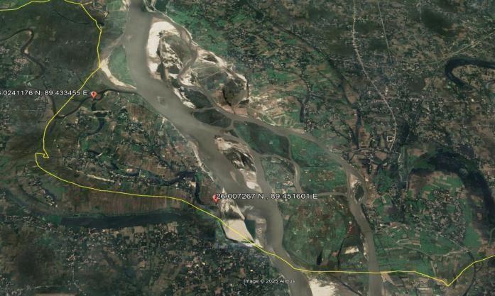
Inthisstudy,thefocus islimitedonly totheDharla river portionbetween JariDharala, Daribosh, andDhamaligachh Areas, because Dhamaligachh area is located just a few meters upstream fromBangladesh border along withMadnakuraBorder Outpost(BOP).So,thisareaand theriverreachhavestrategicalimportancefromsecuritypoint ofviewtoo.Thesitelocation is showninFig.1.
Geographically, thestudy area lies between fromLatitude=260241176 N,Longitude=89433455 EtoLatitude=26007267 N , Longitude=89451601 E

e-ISSN: 2395-0056 p-ISSN: 2395-0072
Fig-1: AreabetweenDaribosh&Jaridharala andDhamaligachhalong theinternationalboundary
3. METHODOLOGY
This study used high-resolution satellite imagery from Google Earth and Landsat-8 data to delineate the bank lines of the DharlaRiveraccurately Satelliteimages from2016to2025werecollectedatannualintervalsthroughEarthExplorer, with all images selected from non-monsoon periods to avoid the influence of seasonal flooding Initial image processing, including band combination and mosaicking, was carried out in ArcGIS 1041 to prepare clear composite images of the study area Riverbank lines for each year were digitized using GIS polyline tools, and polygon shapefiles were generated for spatial analysis. A datum lineisdrawnandthislineisdividedintoequally spacedfourteenpoints toexamine bank linemovement in detail forboththe right andleft banks oftheDharla River.Points 1to3areconsidered tobeinupstream reach;Points 4to9 are considered to be in middle reach and Points 10 to 14 are considered to be in Downstream reach.Measurements ofbank line shifting along with theerosionanddepositiontrends arecarriedout withintheGISenvironment Intheshiftinganalysis; negative values represent shifting of banklines toward the country side and positive values represent shifting of banklines towardriverside Inthemigrationanalysis;erosionisconsideredasnegative,whiledepositionisrepresented aspositive
4. RESULTS & DISCUSSIONS
In ArcGIS1041; a datum line is drawn from JariDharala, Daribosh to Dhamaligachh areaanditisdividedinto equally spaced fourteen points to findtheshiftingstatusat the country andriver sidealongwiththeerosionanddeposition at thebothriver banks Polylinesareusedtodraw bank linesat boththeleft andright bank fortenconsecutive yearsfrom 2016to2025as shown inFig-2.
To study shifting status at the country and river side of both the banks; consecutive years from 2016to2025isusedwitha interval of 1 year. In which the distance of bank line between two consecutive years at all fourteen points are used for evaluating shifting status at all fourteen points for each year up to2025 Forthestudy ofmigration atthebothleft andright bank;2016isconsidered asabaseyear.Atboththeriverbanks; withrespect tothebaseyear2016; thedistanceofbank linefor each consecutive year up to 2025 from the datum line is measured to evaluate migration pattern.
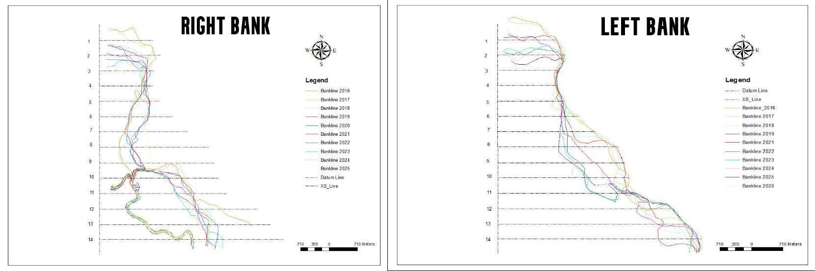
BanklineofDharlaRiverfrom2016-2025 atboththerightandleftbanks withrespecttodatumline
4.1 Study of Bank line Shifting of Dharla River From 2016-2025
Table-1andTable-2representscombined shiftingofbanklinesatallequallyspacedfourteenpointsfrom2016with one year intervalupto2025witheachsuccessiveyearfor bothcountryandriversidesatrightbank and leftbank respectively.Inthe abovetable,negativevaluesrepresents shiftingofbank linestowardcountrysideand positivevaluesrepresent shifting of banklinestowardriverside
Bank-lineshiftingfrom2016to2025atrightbankofDharlariver

e-ISSN: 2395-0056 p-ISSN: 2395-0072 Volume: 13 Issue: 05 |May 2026 www.irjet.net
5. CONCLUSION
Between 2016 and 2025, the Dharla River showed noticeable bank line shifting along both country and riverside Atright bank; points 1, 2, and 3 in the Jaridharala and Daribosh areas shifted towards the country side during 2016–2018, while points 4 to 9 later migrated toward the country side during 2019 to 2025 In the Dhamaligachh region, points 10 to 14 remained stable until 2018, shifted toward the river side during 2019 to 2021, partially returned tocountry sidein2022, and again moved away during 2023 to 2025 At the left bank; points 1 to 9gradually shifted toward riversidethroughout 2016 to 2025, whereas points 10 to 14 first shifted towards the country side during 2016 to 2020 and later moved away after2021.
Byobserving migrationintherightbankofDharlaRiverfrom2016 to2025; itcanbeconcludedthatthepoints 1, 2, 3,12, 13, 14are more prone to erosion and less stable On the other hand; points 5,6,7,8,9aremorepronetodeposition and are relatively more stable Again, by observing migration in the left bank ofDharlaRiverfrom2016to2025;itcanbe concluded thatthe points 3,4, 5,11, 12, 13 and14aremorepronetoerosionandlessstable Ontheotherhand; points6, 7, 8,and 9aremorepronetodepositionandmorestable
From the conclusion of Shifting and Migration; a erosion vulnerability map can be prepared to show the relative risk of erosionvulnerableriverreachesatboththeleftand right banksofDharlariverasshowninFig-3
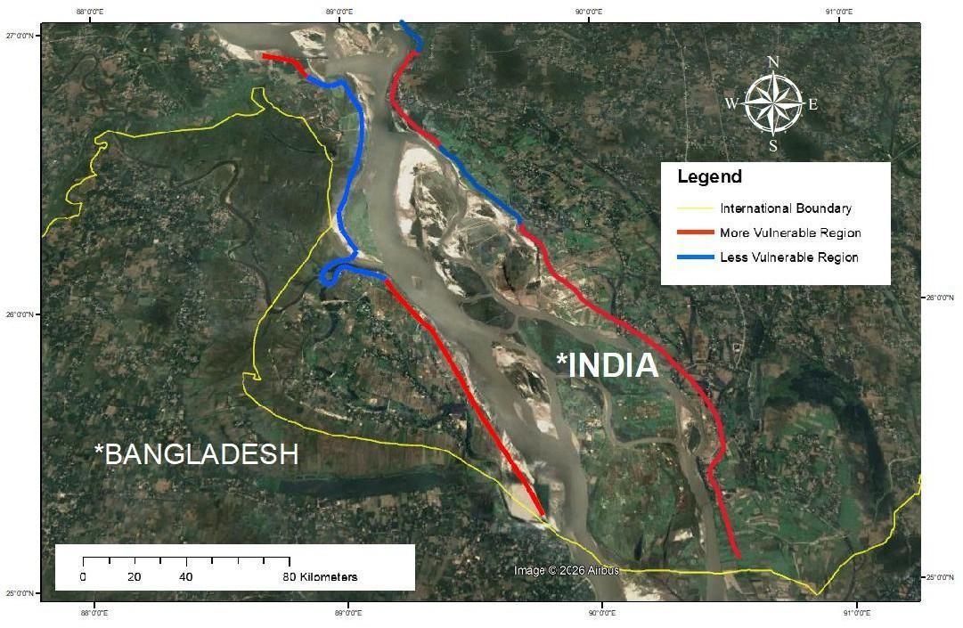
Fig-3: Mapshowingerosionvulnerablereaches ofDharlariver
International Research Journal of Engineering and Technology (IRJET) e-ISSN: 2395-0056 p-ISSN: 2395-0072
Volume: 13 Issue: 05 |May 2026 www.irjet.net
REFERENCES
[1] Mantu Das and Snehasish Saha (2021); “Spatiotemporal Detection And Delineation of Bhagirathi-Hooghly River Bank ErosionUsingGISAnalytics,WestBengal,India” ;Journal ofGeospatial Technology forEnvironmental Hazards;Pp 513537.
[2] Dr. Md Jahir Bin Alam, Uddin Md Misbah, Junayed Uddin Ahmed, Habibur Rahman (2007); “Study of morphological change ofRiverOldBrahmaputraanditssocialimpactsbyremotesensing” ; JournalofGeographica Technica;Volume 2, Issue2,Pp 1-11.
[3] Koyel Roy,Pritam Saha,Sushanta Das,Madhumita Mandal andShasanka Kumar Gayen(2023); “Monitoring TheShifting Nature of River Singimari and Its Impact onRiverside LandUseAndLandcover InDinhata-IAndSitai Blocks ofCooch BeharDistrict,WestBengal,India.” ; JournalofEnvironmental Management andSustainability InIndia;Pp75–99.
[4] Sultana Jahan Ophra, Sameena Begum, Raihanul Islam and Md Nazrul Islam (2018); “Assessment of Bank Erosion and Channel ShiftingofPadmaRiverinBangladeshusing RSAndGISTechniques”; Journal ofSpatial InformationResearch
[5] Jogendra Nath SarmaandShuklaAcharjee (2018);“AStudy onVariation inChannel WidthandBraiding Intensity ofthe Brahmaputra RiverinAssam,India” ;Journal ofGeosciences;Volume8,Issue9.
[6] Dipsikha Devi, Nilutpal Phukan and Bibhash Sarma (2018); “A Study of Erosional Depositional Activity and Land Use Mapping of Majuli River Island Using Landsat Data” ; Hydrologic Modeling, Water Science and Technology Library; Volume81;Pp.187-200.