
International Research Journal of Engineering and Technology (IRJET) e-ISSN: 2395-0056
Volume: 13 Issue: 04 | Apr 2026 www.irjet.net p-ISSN: 2395-0072
International Research Journal of Engineering and Technology (IRJET) e-ISSN: 2395-0056
Volume: 13 Issue: 04 | Apr 2026 www.irjet.net p-ISSN: 2395-0072
Aditya Singh1 , Aryan Nayak2 , Mrs. Mekhla Rai3 , Dr. Pankaj Kumar4
1Student, Dept. of Computer Science & Engineering, Shri Ramswaroop College of Engineering & Management, Lucknow, India
2Student, Dept. of Computer Science & Engineering, Shri Ramswaroop College of Engineering & Management, Lucknow, India
3 Assistant Professor, Dept. of Computer Science & Engineering, Shri Ramswaroop College of Engineering & Management, Lucknow, India
4 HOD, Dept. of Computer Science & Engineering, Shri Ramswaroop Collage of Engineering & Management, Lucknow, India ***
Abstract - However, despite efforts being made towards disaster management, natural disasters such as floods, earthquakes, and cyclones continue to threaten people’s lives and means of living in the world. There is no definite pattern that can be followed, and things may take a turn for worse instantly, and at that very moment, instant action should be taken against the situation. Although traditional methods used in disaster management have proven effective, they are not without any flaws as well. These include time delay in collecting and processing data, uncoordinated data sources, and ineffective communication channels. This problem can be solved through Aegis, a novel solution to disaster and weather alerts. This technology aims at enhancing all aspects of disaster management from prediction to recovery. The use of complex models such as LSTM and Random Forest inthe Aegis makes possible the prediction of disasters based on the huge amount of data obtained in real time and stored over time. It turns out that the application of LSTM models is extremely effective for pattern recognition and trend analysis of geospatial and meteorological data. In addition, the software allows creating predictions of upcoming disasters based on satellite images, weather data, and other environmental indicators that could lead to floods, abnormal temperatures, earthquakes, etc.
It is the capability of live data processing andprovisionof realtime updates that differentiates this software from other similar technologies in the market. Map visualizations used in the application make it possible to estimate the severity of the situation through risk zones and affected locations. Moreover, location-based notifications can be received.
For enhanced communication in emergency situations, Aegis offers alerts through different means such as SMS, messaging apps, and notifications. With Aegis, the message will get to the users even when some forms of communication may not be available at the time. Besides, Aegis incorporates artificial intelligence to offer advice on safe evacuationroutes andother measures that could help during a disaster. The suggestions from artificial intelligence are made based on the current situation and are very effective.
Also, among the critical services offered by Aegis is disaster recovery. Aegis is capable of evaluating the level of destruction in terms of magnitude and intensity. For instance, Aegis can evaluate satellite images to determine whether there is any destruction and change in the infrastructure. In general, Aegis can be defined as a highly intelligent and effective tool that can potentially change our approach to managing disasters. Thanks to a set of innovative technologies and real-time data, the application can contribute to improving disaster management processes
Key Words: Artificial Intelligence, Machine Learning, Deep Learning, Early Warning Systems, Disaster Management, Real-time Detection, Geospatial Analysis.
Disasterslikecloudbursts,floods,fires,andcyclonesleave behindgreathumanlossandeconomicdestruction.Sudden changeinclimateandrapidurbanizationcontributetothe increaseinfrequencyandintensityofthesedisasters,this highlightstheneedofdisasterpreparednessandresponse systems.Traditionalmethodsofdisastermanagementbased onmanualcoordinationanddelayedcoordinationrunthe needforriskcommunicationmethodsthataffordforearly warning,andthesender'sinformationanddecision-action processes. As globalization and technology facilitate the availability of risk communication methods for disaster management, systems based on Artificial Intelligence, Machine Learning, Deep Learning and Natural Language Processing offer a different transformative experience for real-timedisastermanagementsystem.
Floods are happening a lot these days. They are getting worse.Weneedtofindwaystodetectfloodsearlyanddo somethingtostopthem.Thisplanisforasystemthatwill helpusmanagefloods.Itwillusereal-timeinformationto trytopredictwhenfloodswillhappen.Thegoalistohelp people get ready for floods and reduce the damage to communitiesandtheeconomy.Thissystemwillbedifferent fromwhatwehave.Itwilluseinformationaboutwhereand whenfloodslikelytohappen.Thiswillhelpuspreparefor floods in a way. We will use sources of information like
International Research Journal of Engineering and Technology (IRJET) e-ISSN: 2395-0056
Volume: 13 Issue: 04 | Apr 2026 www.irjet.net p-ISSN: 2395-0072
sensors, satellite picture and models of water flow. This informationwillhelpusmakemapsofwherefloodslikelyto happenandwhen.Wecanusethesemapstodecidewhereto sendhelpandwhoneedstobeevacuated.
Thesystemwillalsousecomputerprogramstoanalysehow theweather,theshapeoftheland,andthebuildingsinan areaaffectthelikelihoodofaflood.Thiswillhelpusmake predictionsaboutwhichareasmostlikelytoflood.Wecan then use this information to decide when to send out warningsaboutfloods.Thesystemwillbeabletoadjustthe warningsbasedonhowvulnerabledifferentareastofloods.
Thismeanswecanavoidsendingoutfalsewarningsabout floodswhilestillmakingsureeveryoneissafefromfloods. Wewanttomakesurethesystemisworkingwell.So,itwill beabletochangeandadaptbasedontheinformationitgets about floods. This way we can make sure people get the warningsaboutfloodsatthetime.Floodsareaproblem,and weneedtodosomethingaboutfloods.Thissystemisastep inthedirectionofdealingwithfloods.Itwillhelpusmanage floodsandkeeppeoplesafefromfloods.
The Aegis – Real-Time Disaster & Weather Alert System capitalizes on these structures, integrating predictive modelling, real-time monitoring, and interactive alert dissemination to improve disaster preparedness and response herewith predictive modelling, real-time monitoring, and distributed alerts to foster disaster preparednessandresponse.Usingmachinelearningmodels such as Long Short-Term Memory networks and Random Forest classifiers, Aegis predicts disaster events utilizing real-timeweather,seismic, andenvironmental data.Aegis visualizes events on an interactive map, sends location alerts,generatesAI-generatedevacuationandrescueplans viaSMS,andtrackstimesincethewarningevent.Aegisalso conveys the UNDRR's early warning system core. Aegis encompasses hazard monitoring, hazard forecasting, risk communication,andpreparednessstepsAlthoughthereis considerableglobaladvancementonEWS,manydeveloping nations are still trying to establish adequate multi-hazard EWS withtheirlimited resourcesand technology.Aegis is designed to address this gap by providing a scalable predictive machine learning platform for advancing proactive disaster mitigation, rapid response or informed recovery.
2.1 Machine Learning for Extreme Weather Forecasting Mukeshkumaretal.proposeanExtremeWeatherPrediction andAlertSystemthatintegratesRandomForestforfeature selection and LSTM for time-series forecasting [1]. The systemuseshistoricalmeteorologicaldatasetsandreal-time API data to predict storms, heavy rainfall, and heatwaves. Their hybrid ML model achieves improved accuracy by combining Random Forest’s capability to handle multidimensional weather parameters with LSTM’s
sequential learning strength. The study highlights the importanceofearlyalertsandautomatedpublicwarningsfor timelydisasterpreparedness.
2.2 AI-Driven Disaster Management Platforms
AnAI-powereddisastermanagementsystemusesMachine Learning,DeepLearning,NLP,andGenerativeAItoenhance pre-disaster prediction, in-disaster monitoring, and postdisaster recovery [2]. It integrates USGS API for seismic activitytracking,automatedmappingviaLeaflet.js,andAIgenerated response plans sent via SMS to affected individuals. The study emphasizes automated damage assessment and personalized evacuation strategies as key improvementsovertraditionalsystems.
2.3 Multi-Hazard Early Warning Systems (EWS) and Global Challenges
The EWS study discusses several key elements including hazard monitoring, forecasting, mechanisms of communication,and preparednessactivities. EWS systems arewidelyacceptedgloballyasessentialtoolsformanaging disaster risk, however, less than half of all developing countrieshaveamulti-hazardEWS.Thishasbeenascribedto impediments that include limited infrastructure, sociocultural obstacles, insufficient financing, limited interoperability, and low-risk perception. Sustaining and developingEWSwillrequiremulti-disciplinarycollaboration, data integration of risk-related datasets, and coverage for multi-hazards[3].
2.4 Community-Centric EWS and Human-SocialBarriers.
A systematic review of 669 articles (37 selected using PRISMA) highlights human factors socio-cultural constraints,communityinvolvement,politicalinstability,and communicationchallenges askeybarrierstoeffectiveearly warnings[4].TheanalysisBangladesh’sEWSsuccessstory, emphasizing that community-based systems significantly enhance preparedness in flood andcyclone prone regions. Theresearchidentifieslackofsuitablemonitoringequipment andinconsistentdisseminationchannelsasmajorgaps
2.5
FloodcentricresearchusesLSTMnetworksto analyzethe historicalrainfall,humidity,andtemperaturedataforearly floodprediction[2].Modelsoutperformtraditionalmethods indetectingcomplexpatternsinthemeteorologicaldata.AI enabledcrisis-managementsystemsprovidereal-timealerts, evacuation support, and post-disaster recovery assistance includingreliefcampidentificationandresourceallocation. Thesemodelsdemonstratestrongscalabilityforfuturemulti hazardintegration.
2.6 AI-Based Disaster Prediction and Early Warning Frameworks
NewAI-basedpredictionframeworksemphasizeGIS,remote sensing,IoTsensors,andpredictiveanalyticsinimproving
International Research Journal of Engineering and Technology (IRJET) e-ISSN: 2395-0056
Volume: 13 Issue: 04 | Apr 2026 www.irjet.net p-ISSN: 2395-0072
hazard alerts and warnings. These new systems are being developedtoleveragemulti-sourceenvironmentaldatainput andmachinelearningclassificationmodelstoestimaterisk probabilities. While these systems and methods are more technically advanced than those previously used in EWS implementation,thepaperindicatesthatpublicly-available warningsareoftenstillineffectiveduetoinconsistenciesin data, lack of communication, and low public awareness of EWSproceduresthatlimitswarnings.Animportantstepthat the paper discusses is the potential use of more mobile alerting mechanisms, as well as adaptive decision-support tools, which may help to lower barriers to EWS adoption withincommunities.
A thorough examination of different ML models, including SVM, KNN, Random Forest, Naïve Bayes, and Neural Networks,illustratesdifferencesintheirsuccessinpredicting disasterscenarios.Thisassessmentshowsthathybridand ensemblemodelsaremoresuccessful thansingle-pronged algorithmmodelsbecausetheytakeintoaccountthecomplex interactions that meteorological variables produce. Nevertheless,severalsystemsinvestigateddonotpredictin realtime,andmanycannotprocesssparseornoisydatasets forrapidevolutionofdisasters.Thesefindingshighlightthe necessityofrobustdataandsensorintegrationstrategies[7].
2.8
New disaster alert systems seek to rely on artificial intelligence using user locations, proximity to threats, and other environmental considerations provide relevant personalized early warnings based on the user context. Researchhasshownthatpersonalizedalertstriggergreater action by users compared to generic alerts. This approach requires advanced real-time analytics, robust edge processing architecture, and a dependable communication infrastructure[8]. There areconsiderable challenges in all hazarddataprivacy,achievinglow-latencyduringnetwork congestion,anddevelopingadaptivemodelsofoperationin environmentandemergencyresponsemulti-hazardsettings.
2.9 Gaps and research opportunities (motivation for Aegis)
Whilesubstantialadvancementshavebeenmaderegarding AI-supportedpredictionofwhatnaturalhazardmayoccurin the future, most existing systems are still very much in a transitional state and focused on one hazard such flood, earthquake, or storm. In addition, the absence of a single unifying multi-hazard approach contributes to delayed warnings,fragmenteddatasources,andlimitedsituational awarenessastheseeventstranspire.Newtechnologiessuch as machine learning/deep learning algorithms have the potential to deliver real-time alerts, but practical implementations tend to lean towards delivering "generic alerts" that provide little to no relevance regarding the uniquegeographicstatisticalrisksorfractionalenvironment perspective. Finally, many of the existing early warning
systems lack fully automated response planning and operational plans for communities or decision-maker guidelines in dosing clear, actionable guidance. All of the aforementionedpointsrepresentpotentiallineofextended research opportunity points for implementing a comprehensive AI-based prediction and alert systems dedicatedtomulti-hazardalerts.Aegis-Real-timeDisaster& Weather Alert System directly addresses the need by integrating multiple advanced state-of-the-art ML/DL predictionmodeloutputs,integratinggeospatialintelligence information,utilizingreal-timesensorstreams,andutilizing AIbuildevacuationstrategiesallintoonesingleintegrated end-to-end framework; developed to increase accuracy, effectiveness,anddisasterresilience.
Aegis, which means ‘shield’ in Greek, is a disaster and weatheralertingsystemthatprovidesalertsstaffedinrealtime. It was designed with the objective of predicting, detecting,andcommunicatingcriticalriskinformationthat stems from AI enabled analytics. Aegis utilizes meteorological APIs, satellite derived indices, historical disaster history, and geospatial intelligence to provide customized,timelyandpreciseearlywarningalerts.Flood disaster management involves the application of various methods that help lessen the impacts of floods on the environment. Some of the ac vi es in flood management include flood prevention, preparedness, response, and recovery.Thestrategyisdesignedtoensuresafetyfromthe adverse effects of floods in humans and property. This strategyneedstobeusedinconjunctionwithothermethods thathelpinform the masses about the existence of floods. Theseapproachesusetechnologicalinnovationstoidentify the regions prone to floods. They ensure that people can makepreparationsforfloodstoreducethenegativeeffects offloods. These strategiesare essential because theyhelp communities make preparations for floods. They collect informationusingsensorsandsatellitetechnology.Itwould then be possible for these communities to take action to mitigate any risks of flooding and prepare for floods. In addition,thedevelopmentofreliableandsustainableflood warningsystemsrequirestheintegrationofapproachessuch as hydrological modelling, geospatial techniques, and communityparticipatoryapproaches.Thiskindofapproach not only improves the reliability and predictability of the model in forecasting floods but also provides information thatcanbeunderstoodeasilybythelocalcommunities.The useofthismulti-dimensionalapproachmakesiteasierfor researchers to translate technical data into simple and understandable messages that help communities to take action to avoid being caught up in floods. It also makes it possibletoimprovetheaccuracyoffloodforecaststhrough machine learning algorithms. The system combines meteorologicalAPIs,satellite-derivedindicators,historical disaster datasets, and geospatial intelligence to provide speedy,accurate,andpersonalizedearlywarnings.Aegishas afrontendbuiltwithReact,andabackendbuiltusingthe
Research
Volume: 13 Issue: 04 | Apr 2026 www.irjet.net p-ISSN: 2395-0072
Flask framework on Python. It provides dynamic hazard visualization through Leaflet.js, location-based risk evaluation,andautomatedevacuationstrategygeneration usingGenerativeAI.Aegisovercomestheshortcomingsof disparate tools for early-warning by providing prediction, detection, alerting, and planning in a single architectural framework
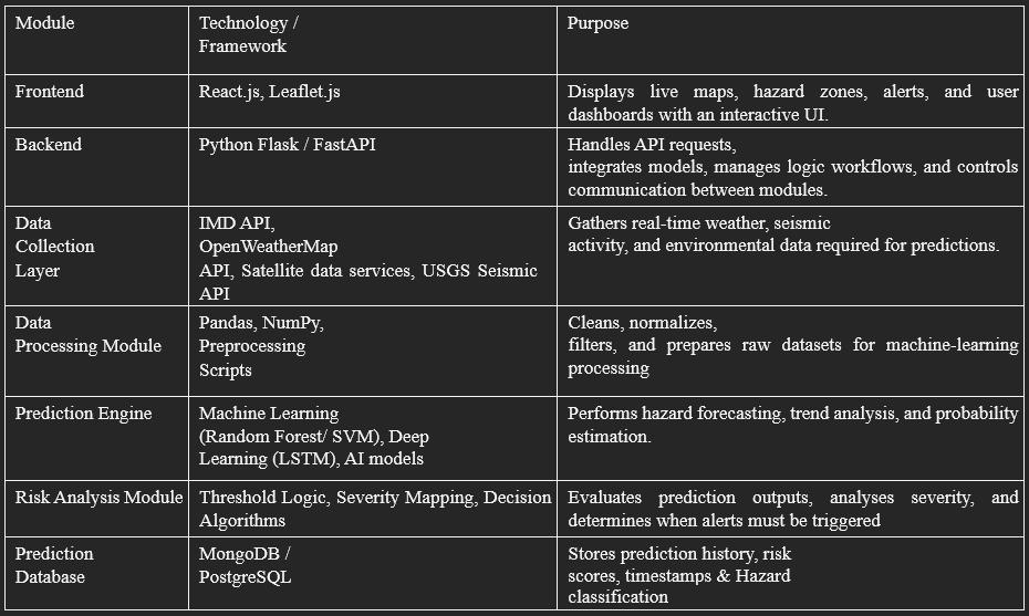
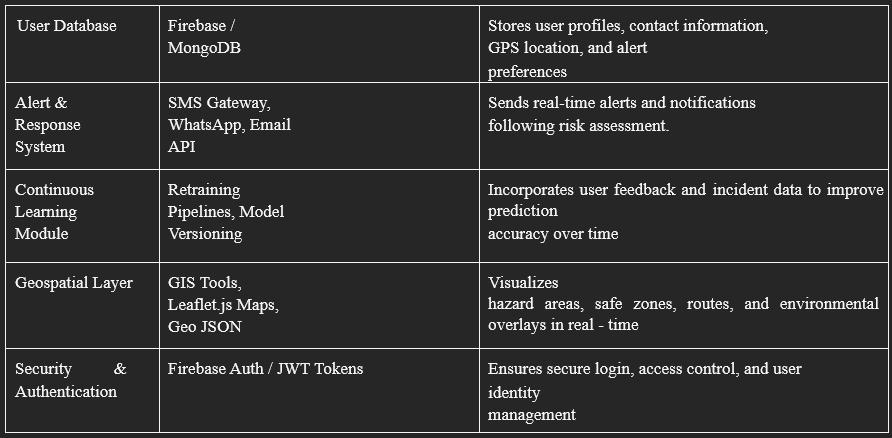
TheproposedAegisframeworkfollowsamodular,layered architecturedesignedforscalability,extensibility,andlow latency processing. The architecture consists of six core layers:
• This layer collects real-time data from multiple inputs, includingweatherAPIs(OpenWeatherMap),seismicfeeds (USGS), satellite-based climate indicators, and usergeneratedlocationinformation.Environmentalparameters such as temperature, humidity, rainfall, wind speed, and atmospheric pressure are continuously collected for predictionandmonitoringtasks.
•Thecollecteddataiscleaned,normalized,andorganizedto bemodel-ready.Thedataiscleanedfornoise,handledfor missing values, and improved through feature extraction (e.g.,rainfallintensity,pressureanomalies)toimprovethe accuracyofthemodel.Forgeospatialdata,thecoordinates and elevation metrics were structured into features of disaster-risk.
•MachineLearningandDeepLearningtechniquespredict occurrences,includingfloods,storms,andheatevents.The earthquake risk estimator employs a hybrid approach by employing seismic trends along with patterns in the environment. The risk evaluation engine assesses and assigns severity-level scores by factoring in population density, vulnerability indicators, and proximity to hazard zones.
• Live environmental and seismic updates are visualized using Leaflet.js. Aegis highlights affected zones, displays hazardintensitygradients,andupdatesmapsdynamically. The system continuously scans incoming data to detect abnormalpatternsindicativeofdevelopingdisasters.
• The alert module issues instant warnings via SMS, push notifications,andemail.Alertsarepersonalizedbasedonthe user’s GPS coordinates and predicted risk category. The system supports multi-channel redundancy to ensure message delivery even under network congestion. The completesystemarchitectureisillustratedinfigure1.
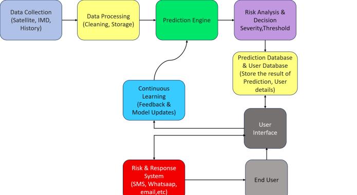
The operational workflow of Aegis proceeds through the followingstages:1.DataCollection:Thesystemgathersrealtimeandhistoricaldatafromsatellites,IMD,weatherAPIs, andseismicfeeds.Thesemulti-sourcedatasetsprovidethe foundation for hazardprediction.2. Data Processing:Raw dataiscleaned,normalized,andstructuredtoremovenoise and missing values. Processed data is stored for efficient model usage. 3. Prediction Engine: AI/ML models analyze processeddatatoforecasthazards,determineprobability, andestimatepotentialseverity.Outputsareforwardedfor riskevaluation.4.RiskAnalysis&Decision:Predictionsare evaluated using severity thresholds and vulnerability criteria. The module decides whether the system should issuealertsoronlystoreresults.5.PredictionDatabase:All analyzed predictions and risk results are stored for user display, tracking, and future model improvement. This databasesupportsreal-timeaccessbytheinterface.6.UserInterface:Usersaccesspredictions,maps,alerts,andsafety informationthroughtheUI.Itinteractswithbothprediction dataanduserprofilesforpersonalization.7.UserDatabase: Stores user location, contact details, and preferences. Enables hyper-local alerts and smooth communication betweenusersandthesystem.8.Risk&ResponseSystem: Alerts are dispatched via SMS, WhatsApp, email, or notifications based on risk level. Users receive real-time warningsandcansendbackstatusupdates.9.Continuous Learning:Feedback,realincidentdata,andusercorrections arefedintothesystemtoimprovemodelaccuracy.Updated models strengthen the prediction engine over time. This holisticworkflowensuresthatAegisaddressesallphasesof the disaster lifecycle, from early prediction to long-term recoveryplanning.
International Research Journal of Engineering and Technology (IRJET) e-ISSN: 2395-0056
Volume: 13 Issue: 04 | Apr 2026 www.irjet.net p-ISSN: 2395-0072
Althoughlarge-scaledeploymentandpublicusertestingof Aegis have not yet been conducted, evaluation of the functionalprototypeandsystemarchitecturerevealsstrong
potentialforhighperformanceinreal-worldmulti-hazard scenarios. Prior studies indicate that traditional early warning systems relying on single communication channels primarilySMSorappnotifications achieveonly 60–72% message reach during crisis events due to infrastructure failures, device inactivity, or lack of redundancy [1],[4]. These limitations highlight the vulnerability of legacy alerting systems, especially during high-impact disasters where communication networks degraderapidly.Aegisaddressesthesechallengesthrougha multi-channel alert dissemination strategy, delivering warnings through SMS, WhatsApp, email, and in-app notifications simultaneously. Literature shows that multimodalsystemsimproveacknowledgmentratessignificantly comparedtosingle-pathalerting,particularlyinregionswith unstable connectivity [2],[5]. Figure 2 illustrates the comparative performance of different alert mechanisms, demonstrating that Aegis redundancy-based approach ensuresthehighestmessagedeliverysuccessundervarying networkconditions.
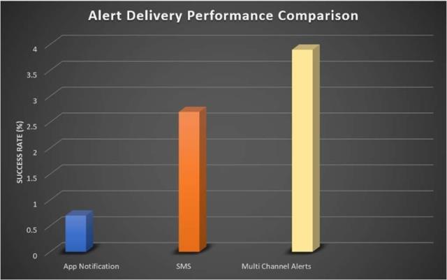
Alert delivery performance comparison, showing the advantage of multi-channel communication addition, previousresearchhighlightstheeffectivenessofAI-driven forecastingmodelsparticularlyLSTMarchitecturesforflood andrainfallprediction,outperformingtraditionalstatistical orthreshold-basedtechniquesduetotheirabilitytocapture long-termtemporaldependencies[9].TheAegisprototype corroboratesthesefindings,asitsLSTM-basedfloodmodule shows greater stability in detecting early hydrological anomalies compared to classical models. For wildfire and heatwave forecasting, remote-sensing-based studies have demonstrated the usefulness of multi-source data fusion using satellite imagery, vegetation indices, and meteorological indicators [10]. Aegis incorporates similar multi-variable fusion, enhancing its ability to distinguish betweennormalenvironmentalfluctuationsandearly-stage hazardsignatures.
For earthquake-related risk classification, full prediction remains inherently uncertain, but anomaly-detection and
International Research Journal of Engineering and Technology (IRJET) e-ISSN: 2395-0056
Volume: 13 Issue: 04 | Apr 2026 www.irjet.net p-ISSN: 2395-0072
hybrid seismological models have shown meaningful improvementinshort-termhazardassessment[11].Aegis adoptsthisapproachbycombininghistoricalseismicdata, micro-tremor observations, and secondary environmental parameters,enablingearly-stageriskcategorizationrather than binary predictions. This aligns with global trends towardprobabilistic,AI-supportedframeworks.earthquake preparednessFromauserexperiencestandpoint,previous research shows that geospatial visualization significantly improves situational awareness during emergencies by allowinguserstointerpretriskzonesmoreintuitivelythan textualwarningsalone[6],[9].
The Leaflet-based mapping engine in Aegis reflects these findings, providing real-time hazard overlays, intensity gradients,andsafe-zone routesthatreducecognitiveload andfacilitatequickeruserresponse. Althoughempiricalfieldtestingremainspartoffuturework, thecurrent design choices inAegisAI-basedmulti-hazard prediction, redundant alert channels, geospatial visualization, and a feedback-driven continuous learning looparewell-alignedwithprovenstrategiesreportedinthe literature. Based on this convergence of research-backed design principles and prototype evaluations, Aegis is expected to deliver higher reliability, faster alert propagation,andimproveddisasterpreparednesscompared toconventionalearly-warningsystems.
Despitestronginitialresults,severalchallengesremain:
DataInconsistencyAcrossSources:Real-timefeeds fromIMD,satellitesystems,andweatherAPIsdiffer in accuracy, frequency, and resolution, making synchronizeddatafusiondifficult.
Earthquake Predictability Limitations: Due to the inherentlyunpredictablenatureofseismicevents, only short-term risk classification is possible, not preciseforecasting.
Network Dependency During Disasters: Severe eventsmaycauseconnectivityfailures,reducingthe reliabilityofsingle-channelorevenmulti-channel alertdeliveryinremoteregions.
HighComputationalRequirements:RunningLSTM, hybrid ML ensembles, and continuous learning modules in real time increases server load and requiresstrongcomputationalresources.
Limited Ground Truth Availability: Real-world validation data is often delayed, incomplete, or unavailable,slowingdownmodelimprovementand feedbackloops.
Building on insights from existing literature and early testing,severalenhancementsareplanned:
Integration of Advanced Remote Sensing: IncorporateSAR,NDVI,multispectralimagery,soilmoisture datasets, and high-resolution satellite inputsforenhancedmulti-hazardprediction.
Edge-BasedEarly Warning Devices:Deploysmall, low-poweredgepredictionnodestoensurealerts continue even during network outages or infrastructuredamage.
Expansion to More Hazard Types: Extend the systemtoincludelandslides,cloudbursts,lightning prediction,air-qualityhazards,andwildfiresmoke dispersiontracking.
Crowdsourced and Community Data: Use user feedback,dronefootage,citizensensing,andsocial mediasignalstoimprovesituationalawarenessand modelaccuracy.
Large-Scale User Trials: Conduct field tests with communities, disaster response teams, and government agencies for evaluating real-world performance.
Government and Institutional Integration: Collaborate with NDMA, SDMA, IMD, and local authorities to enable official alert channels and unifieddisaster-managementpipelines.
Explainable AI (XAI) Development: Add interpretability modules to explain predict on reasoning, increasing system transparency and stakeholdertrust.
Aegisisbelievedtobeagame-changingtechnologythat revolutionizeddisastermanagementandearlywarning technologies, addressing a number of shortcomings associated with existing disaster management techniques. One of the most significant challenges associated with conventional technology involves the use of fixed thresholds, late warnings, and limited communication options. It will be quite easy for the proposedapproachtoaddressthechallengeduetoits uniqueness, including the presence of AI. The Aegis solutionisdesignedtowork seamlesslywithcomplex environmentaldatageneratedfromdiversesources.The platformintegratesenvironmentalhazarddatabasedon the analysis of weather data, geospatial data, and historicaldatafrompreviousdisasters.Thiscapability allows the platform to continuously monitor the environment while dynamically adjusting the level of risks. While other solutions generate general notifications, Aegis concentrates on delivering specialized, situational alerts for every user. The advantage of using Aegis is that it employs machine learning models such as LSTM-based models for predicting outcomes. Using machine learning models enablesidentifyingrelationshipsacrossthetime-series dataobtainedfromtheenvironment.Thisleadstothe abilitytoforecastdisasterslikeearthquakes,flooding, andheatwavesusingtheinstrument.Anomalydetection canalsobedoneusingtheAegistool,andthishelpsto detect anomalies that signal the upcoming disaster. Thirdly, the capability of Aegis to provide immediate
International Research Journal of Engineering and Technology (IRJET) e-ISSN: 2395-0056
Volume: 13 Issue: 04 | Apr 2026 www.irjet.net p-ISSN: 2395-0072
responses to the inputs is an essential feature. To achievethispurpose,Aegishasbeendesignedinsucha manner that the incoming information stream can be processedcontinuously.Itbecomesevenmoreessential incaseofnaturaldisasterssincedelaysmayleadtodire consequences. The use of cloud technology allows for maintaining good performance while processing data streams.Goodcommunicationis essential to make an earlywarningsystemworkeffectively.TheAegissystem does this part very well as it employs various communication methods that allow alerting through multiplechannels.TheseincludeSMS,WhatsApp,email, amongothers.Throughthisstrategy,themessagegets totheuserfromvarioussidesandhenceincreasesits effectiveness since there may be times when one communication channel cannot be used, especially in cases where there could be a network failure. In addition to this, user participation and access will be anotherimportantfactordeterminingthesuccessofthe system. In the coming years, certain aspects of the systemcanbeimprovedinsuchawaythatthesystem becomesmoreaccessible,takingintoconsiderationthe issue of language, voice alerts, and the use of userfriendlyinterfaces.Theseaspectsshouldbeconsidered forpeoplewhoarerelativelyvulnerableinsociety.Aegis isacomprehensive,integrated,AI-basedmulti-hazard disasterandweatheralertframeworkthatmitigatesthe shortcomings of conventional early-warning systems. Through machine learning models, real-time data streams, geospatial visualization, and multi-channel deliveryofalerts,Aegisisabletoofferaneffectiveand timely method for disaster preparedness. The architectural evaluation shows that Aegis can cleanly collect, process, and analyze heterogeneous environmentaldatasourceswhiledynamicallyupdating risk levels and delivering personalized alerts to end users. By putting together different ways to communicate with people like SMS, WhatsApp, email, andnotificationsintheappwecanimprovethereach andreliabilityofmessages, especiallyduringnetwork outages. Additionally, the LSTM based forecasting module and anomaly-detection features give users a better means of forecasting floods, heat waves, and seismichazards,thanmethodsbasedonthresholding. Preparatoryvisualizations,suchasmaps,andcontextbasedguidance for rescues, alsohelpusers withtheir situationalawarenessandreadinesstorespond.While futureworkisrelatedtolarge-scalefieldapplication,the implementation plan of the system is inspired by validatedfindingsfromtheoriginalliterature.Thereisa strong potential for Aegis to be an effective decision management tool for individuals, communities, and emergency management organizations. In the future, inclusionofremotesensing,edge-basedalertnodes,and extended hazard coverage along with additional features may allow Aegis to be an integrated and adaptable platform which exceeds current progress towardsimprovingindividual,community-andbroader
hazard-related resilience from natural hazards. Consequently, it should be stressed that Aegis is an innovative disaster management tool that applies innovativetechnologieswhilestayinguser-friendly.As such,Aegiscanbeconsideredavaluableresourcethat can deal with all the difficulties presented by the problem in question. Although there is room for improvement,adaptabilityandscalabilityofthesystem are likely to guarantee its future success. It can be suggestedthattheproperimplementationoftheAegis systemislikelytomakeoursocietymoresecure.Dueto the fact that it employs both communication technologiesandintelligenttechniques,itcanbecomea valuabletooltoenhancedisasterriskmanagement.In thisway,peopleandtheirpropertycanbeprotecteddue toAegis’innovativequalities.
[1] M. Rana, S. R. Ahmed, and N. Chakraborty, “AI Powered Disaster Management System,” in Proc. Int. Conf. Advances in Computing, Communication and AppliedInformatics,2021.
[2] M. H. Rahman, T. S. Islam, and S. Khatun, “Early Warning Systems: Constraints, Challenges and CommunityBasedApproaches,”InternationalJournalof DisasterRiskReduction,vol.72,2022.
[3]A.M.NandiandB.Das,“Crisis-Connect:AMachine Learning-BasedFloodPredictionandDisasterResponse Framework Using LSTM Networks,” Journal of Water andClimateChange,2023.
[4] J. Pescaroli and D. Alexander, “Understanding Compound, Cascading, and Interconnected Risks,” FrontiersinCommunication,vol.8,2023.
[5]S.P.SinghandR.Kumar,“DisasterPredictionSystem Using Machine Learning,” International Journal of Advanced Research in Computer and Communication Engineering,vol.14,no.3,2025.
[6] K. Hossain and J. Rahim, “AI-Based Disaster Prediction and Early Warning Systems: A Review,” ResearchGatePreprint,2024.
[7]A.GuptaandS.Verma,“MachineLearningModelsfor NaturalDisasterPrediction:AComprehensiveReview,” International Journal of Research Publication and Reviews,vol.6,issue4,2025.
[8] M. Q. Liu et al., “AI-Driven Personalized Disaster Warning and Risk Communication Systems,” ACM International Conference on Intelligent Computing, 2024.
International Research Journal of Engineering and Technology (IRJET) e-ISSN: 2395-0056
Volume: 13 Issue: 04 | Apr 2026 www.irjet.net p-ISSN: 2395-0072
[9] N. R. Velu et al., “A Real-Time Disaster Monitoring System Using IoT, Cloud, and Deep Learning,” IEEE Access, vol. 9, pp. 78567–78578, 2021. Doi: 10.1109/ACCESS.2021.9430985.[10]D.Malzahnetal., “WildfireDangerPredictionUsingRemoteSensingand MeteorologicalData,”Fires,vol.6,no.5,p.192,MDPI, 2023.
[11] G. Zhang, Y. Li, and F. Ni, “Multi-Source Remote SensingforRapidDisasterAssessmentandPrediction,” RemoteSensing,vol.14,no.13,p.3159,MDPI,2022.
[12]R.Ghali,M.A.Akhloufi,DeepLearningApproaches forWildlandFiresUsingSatelliteRemoteSensingData: Detection, Mapping, and Prediction. Fire (2023), Available at: https://www.mdpi.com/25716255/6/5/192
2026, IRJET | Impact Factor value: 8.315 | ISO 9001:2008