
International Research Journal of Engineering and Technology (IRJET) e-ISSN: 2395-0056
Volume: 13 Issue: 03 | Mar 2026 www.irjet.net p-ISSN: 2395-0072
International Research Journal of Engineering and Technology (IRJET) e-ISSN: 2395-0056
Volume: 13 Issue: 03 | Mar 2026 www.irjet.net p-ISSN: 2395-0072
Saran S, Varshanth D, Jotheshvar S
Saran S, Department of Artificial Intelligence and Data Science, SRM Valliammai Engineering college, Tamilnadu, India
Varshanth D, Department of Artificial Intelligence and Data Science, SRM Valliammai Engineering college, Tamilnadu, India
Jotheshvar S, Department of Artificial Intelligence and Data Science, SRM Valliammai Engineering college, Tamilnadu, India
Abstract Roadinfrastructuresafetyisacriticalconcernin moderntransportationsystems,as surfaceanomalies such as potholes significantly contribute to traffic accidents, vehicle damage, and increased maintenance costs. Conventional roadinspectionmethodsrelyheavilyonmanualsurveysorsensor-basedsystems,whicharetime-consuming,expensive, andunsuitableforlarge-scaledeployment.ThispaperpresentsanAI-poweredroadsurfaceanomalydetectionframework based on the YOLOv4-Tiny deep learning model, designed for real-time detection with lowcomputationaloverhead.The proposedsystemprocesses roadimagesand videostreamstoautomaticallyidentify potholesusing a single-stageobject detectionapproach.YOLOv4-Tinyisselectedduetoitsfavorablebalancebetweendetectionaccuracyandinferencespeed, enabling deployment on CPU-based and edge devices without GPU acceleration. The framework incorporates preprocessing, model inference, post-processing, and visualization modules to deliver an end-to-end detection pipeline. Experimentalevaluationonannotatedroadsurfacedatasetsdemonstratesreliabledetectionperformanceundervarying road and lighting conditions. The system is evaluated using standard metrics including Accuracy, Precision, Recall, F1score,andROC-AUC.Resultsindicatethat the proposed approachachieves competitiveaccuracy while maintaining realtime performance, making it suitable for smart transportation and road maintenance applications. The proposed frameworkoffersascalable,cost-effective,anddeployablesolutionforautomatedroadconditionmonitoringinsmartcity environments.
Keywords Fake News Detection, Machine Learning, Natural Language Processing, Social Media, Instagram, Twitter, Logistic Regression, Stochastic Gradient Descent, Multinomial Naïve Bayes, Random Forest, TF-IDF, Misinformation,TextClassification,AI-BasedDetection.
Rapid urbanization and the continuous growth of vehicular traffic have placed significant stress on road infrastructure worldwide. Road surface anomalies, particularly potholes, cracks, and surface deformations, are a persistent issue that adversely affects transportation safety, driving comfort, and economic efficiency. Potholes not only contribute to traffic accidents and vehicle damage but also increase fuel consumption andmaintenancecostsfor both individualsand public authorities.
Conventionalroadinspection methods predominantlyrelyon manual visual surveys conducted by trained personnel. Although such approaches can provide detailed assessments, they are inherently time-consuming, labor-intensive, and pronetosubjectivejudgment.Moreover,manualinspectionsareimpractical formonitoringlarge-scaleroadnetworksat high frequency. Sensor-based approaches using accelerometers, vibration sensors, or specialized hardware mounted on vehicles have been proposed as alternatives; however, these methods often require additional equipment, complex calibration,andhighdeploymentcosts,limitingtheirscalabilityandadoption.
Advancements in computer vision and deep learning have enabled automated visual inspection systems capable of analyzingroadsurfaceconditionsusingimageandvideodata.ConvolutionalNeuralNetworks(CNNs)havedemonstrated strong performance in extracting discriminative features from road images, enabling accurate classification and localization of surface anomalies. In recent years, object detection frameworks such as Faster R-CNN, SSD, and the You OnlyLookOnce(YOLO)familyhavebeenincreasinglyappliedtoroadanomalydetectiontasks.Amongthese,YOLO-based modelsareparticularlyattractiveduetotheirsingle-stagedetectionmechanism,whichenablesfasterinferencecompared tomulti-stagedetectors.
Despite promising results, many existing deep learning– based road inspection systems employ computationally intensivearchitecturesthatrequireGraphicsProcessingUnits(GPUs)forreal-timeoperation.Thisdependencyrestricts
International Research Journal of Engineering and Technology (IRJET) e-ISSN: 2395-0056
Volume: 13 Issue: 03 | Mar 2026 www.irjet.net p-ISSN: 2395-0072
deployment in resource-constrained environments such as edge devices, embedded systems, and low-cost monitoring platforms commonly used in developing regions. Furthermore, several studies prioritize detection accuracy without adequatelyaddressinginferencespeed,systemscalability,andreal-worldfeasibility.
To address these challenges, this paper proposes an AI- poweredroadsurfaceanomalydetectionframeworkbasedon YOLOv4-Tiny, a lightweight variant of the YOLOv4 architecture. YOLOv4-Tiny significantly reduces model complexity while preserving essential feature extraction and detectioncapabilities,makingitsuitableforreal-timeexecutiononCPU-basedsystems.Theproposedapproachfocuses on achieving a balanced trade-off between accuracy and computational efficiency, enabling practical deployment for continuousroadmonitoring.
Automatedroad-surfaceanomalydetectionisaninterdisciplinaryresearchareathatspansimageprocessing,machine learning,sensorengineering,andintelligenttransportation.Theliteraturecanbegroupedintoseveralcomplementary strands:(a)sensor-andvibration-basedmonitoring;(b)classicalcomputervisionapproaches;(c)deeplearning–based classification and segmentation; (d) object detection methods (two-stage vs single-stage); and (e) deployment and operationalstudiesthataddresslatency,scalability,andedgecomputing.Acriticalsynthesisofthesestrandshighlights both technical progress and persistent gaps that motivate the present work. Early alternatives to purely visual inspection include accelerometer- and vibration-based methods, typically using vehicle-mounted sensors or smartphone inertial measurement units (IMUs) to infer surface defects from dynamic response signatures [1], [2]. These methods are cost-effective and can provide large-area coverage when crowdsourced, but they suffer from low spatial localization precision and high sensitivity to vehicle dynamics, suspension characteristics, and driving speed. Studies such as Ravi and Gupta demonstrated the feasibility of smartphone-driven monitoring but also highlighted difficulties in mapping sensor events to precise visual evidence required for maintenance prioritization [3]. Consequently, vibration-based systems are often complementary to vision-based approaches rather than a complete substitute. Prior to the deep learning era, image- processing methods edge detection, thresholding, morphological operations, and texture analysis were applied to identify discontinuities associated with cracks and potholes [4]. Thesemethodsareattractiveduetotheirinterpretabilityandlowcomputationalfootprint;however,theyarebrittlein real-world scenarios where illumination, shadows, surface wear, and occlusion significantly alter pixel-level statistics. Survey articles emphasize that classical techniques require careful feature engineering and domain- specific tuning, which reduces generalizability across diverse road environments [5]. Theadoption of convolutional neural networks (CNNs) markedly improved robustness to variability in visual appearance. Initial work framed road- damage tasks as image-levelclassificationproblems i.e.,decidingwhetheranimagecontainsdamage usingstandardCNNbackbones. While classification improves detection sensitivity, it lacks localization capability. To obtain pixel- level information, researchers applied semantic segmentation and instance segmentation (e.g., U-Net variants, Mask R- CNN), which provide fine-grained contours of damage [6], [7]. Segmentation approaches excel at delineating irregular shapes but are computationally intensive and typically unsuited for real-time processing on constrained hardware. Dilated or atrous convolution introduced multi-scale contextwithoutexcessivedownsamplingandwasshowntoimprovedetectionofvaryingpotholesizes,butatthecostof increased model complexity [8]. Object detection offers an operational compromise by delivering bounding-box localization with manageable compute. Two-stage detectors such as Faster R- CNN prioritize accuracy through region proposalmechanismsbutimposesignificantlatency[9].Single-stagedetectors(SSD,YOLOfamily)performend-to-end regressionofboxesandclassscores,achievingconsiderablyhigherthroughput.Comparativestudiesforroadanomalies consistently report that single-stage detectors particularly recent YOLO variants provide the best speed–accuracy trade-off for real-time monitoring [10], [11]. YOLOv3 and its successors improved feature aggregation and anchor designs, while YOLOv4 introduced engineering refinements (bag-of- freebies/ bag-of-specials) that boosted empirical performance for general object detection tasks [12]. Nevertheless, these full-scale models remain heavy for edge use; hence, “Tiny” variants (e.g., YOLOv4-Tiny) have been proposed to reduce parameter count and latency, at a modest accuracypenalty[13].Empiricalcomparisonsinthepotholeliteratureshowthatacarefullytunedtiny-modelcanmeet real-timeconstraintswhileretainingacceptabledetectionratesinmanypracticalsettings[10],[14].
International Research Journal of Engineering and Technology (IRJET) e-ISSN: 2395-0056
Volume: 13 Issue: 03 | Mar 2026 www.irjet.net p-ISSN: 2395-0072
The proposed system aims to develop an intelligent and efficient road anomaly detection framework capable of automatically identifying surface defects, particularly potholes, from visualdata.Thesystem isdesignedtoaddress the limitations of conventional road inspection methods by leveraging deep learning–based computer vision techniques to enable accurate, real-time, and scalable road monitoring. By utilizing image and video inputs captured from standard cameras, the proposed approach eliminates the need for manualinspectionandspecialized sensinghardware,thereby reducingoperationalcostandcomplexity.
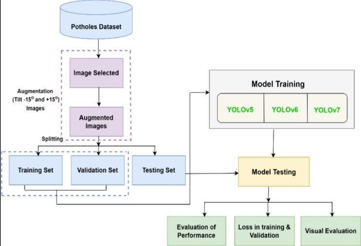
At the core of the proposed framework is a YOLO-based object detection model, specifically a lightweight variant suitable for real-time execution. The system follows a structured processing pipeline that includes data acquisition, preprocessing, deep learning–based inference, post- processing,andresultvisualization. Inputdatamayconsistof live video streams or pre-recorded road footage, which are decomposed into frames and prepared for model inference through resizing, normalization, and basic enhancement operations. These preprocessing steps ensure that the input conformstotherequirementsofthedetectionnetworkandimprovesfeatureextractionconsistency.
The detection engine employs a YOLO (You Only Look Once) architecture, which performs object localization and classificationinasingleforwardpass.Thissingle-stagedetectionparadigmsignificantlyreducesinferencelatencywhen compared to multi-stage detectors, making it well suited for real-time applications. The lightweight design of the selected YOLO variant enables deployment on CPU-based systems without requiring GPU acceleration, which is an important consideration for large-scale or edge-based road monitoring systems. During inference, the model predicts bounding boxes, class labels, and confidence scorescorrespondingtopotentialpotholeregionswithineachframe.
Toenhanceadaptabilityandrobustness,theproposedsystemsupportstheuseoflimitedlabeleddatasupplementedby unlabeled or weaklylabeled samples during data preparation and experimentation. While the core detection model is trained in a supervised manner, the overall framework benefits from semi-supervised principles such as data augmentation, iterative refinement, and exposure to diverse road scenarios. This strategy improves generalization performance across varying road textures, illumination conditions, and environmental complexities, which are commonlyencounteredinreal-worlddeployments.
Unliketraditionalrule-based orthreshold-drivenapproaches, the proposed system relies on learned representations extracteddirectlyfromvisualdata.Thislearning-basedmethodologyallowsthemodeltodynamicallyadapttodifferent road conditions without requiring handcrafted features or static decision rules. Post-processing techniques, including confidencethresholdingand suppression ofredundant detections,areapplied torefinetheoutput and ensure reliable anomalyidentification.Thefinalresultsarevisualizedthroughboundingboxesoverlaidonimagesorvideoframes,and relevantdetectiondatasuchascoordinatesandconfidencevaluesarestoredforfurtheranalysis.
International Research Journal of Engineering and Technology (IRJET) e-ISSN: 2395-0056
Volume: 13 Issue: 03 | Mar 2026 www.irjet.net p-ISSN: 2395-0072
Theproposed framework is inherentlymodular and scalable, enabling easyintegration withhigher-level applications such as smart transportation systems, municipal road maintenance platforms, and infrastructure monitoring dashboards. By automating the detection and localization of road anomalies, the system supports proactive maintenance planning and contributes to improved road safety and transportation efficiency. Overall, the proposed system demonstrates a practical and effective application of deep learning for intelligent road condition monitoring, balancingdetectionaccuracy,computationalefficiency,andreal-worlddeployability.
A. Dataset Details
To develop the road pothole detection system, visual road surface data was collected in the form of images and video sequences. The dataset consists of road images captured under diverse real-world conditions, including varying illumination, road textures, camera angles, and environmental backgrounds. Both pothole-affected and normal road surfaceimageswereincludedtoensurebalancedlearning.
The dataset contains annotated images where potholes are labeled using bounding boxes in YOLO format. Each annotationincludestheclasslabel and normalized boundingboxcoordinates. The diversityof the dataset enablesthe modeltogeneralizeeffectivelyacrossdifferentroadenvironmentsandsurfaceconditions.Thedatasetwasdividedinto training,validation,andtestingsubsetstoevaluatethemodel’sgeneralizationperformanceaccurately.
B. DataPreprocessing
Preprocessingplaysacriticalroleinimprovingdetectionaccuracyandensuringconsistentinputquality.
a) FrameExtractionandResizing
For video inputs, continuous road footageis decomposed into individual frames. All images andframes areresized to matchtheYOLOv4-Tinyinputresolutiontomaintainuniformityduringtrainingandinference.
b) Normalization
Pixel values are normalized to reduce the effect of lighting variations and improve convergence during training. This stepenhancesfeatureconsistencyacrossdifferentsamples.
c) DataAugmentation
To improve robustness and reduce overfitting, data augmentation techniques such as horizontal flipping, brightness adjustment,andrandomscalingareapplied.Thesetechniquesexposethemodeltovariedscenarioswithoutincreasing datasetsize.
C. FeatureLearningandRepresentation
Unlike traditional systems that rely on handcrafted features, the proposed system uses deep feature learning through convolutionalneuralnetworks(CNNs).YOLOv4-Tinyautomaticallyextractshierarchicalspatialfeaturessuchasedges, contours, textures, and shape patterns from road images. These learned features enable effective differentiation betweenpotholesandnon-defectiveroadregions,evenundercomplexbackgrounds.
Multi-scale feature maps allow the system to detect potholes of different sizes and depths, improving detection performanceacrossvariedroadconditions.
International Research Journal of Engineering and Technology (IRJET) e-ISSN: 2395-0056
Volume: 13 Issue: 03 | Mar 2026 www.irjet.net p-ISSN: 2395-0072
D. ModelArchitecture
The core detection engine of the proposed system is the YOLOv4-Tiny object detection model, which is a lightweightandoptimizedversionofYOLOv4.
a)ModelSelection
YOLOv4-Tinyisselectedduetoits:
Single-stagedetectionarchitecture
Lowcomputationalcomplexity
Real-timeinferencecapability
SuitabilityforCPU-baseddeployment
b)DetectionMechanism
The model divides the input image into a grid and predicts bounding boxes, confidencescores, and class probabilities in a single forward pass. This approach significantly reduces inference latency while maintaining reliable detection accuracy.
c) BoundingBoxPrediction
Eachdetectedpotholeisrepresentedusingboundingboxregression,enablingpreciselocalizationofroadanomalies. Themodeloutputsconfidencescoresindicatingthelikelihoodofpotholepresence.
E. TrainingStrategy
Themodelistrainedusingsupervisedlearningwithlabeledroadimages.
LossFunction:YOLOlossfunctioncombininglocalizationloss,confidenceloss,andclassificationloss
Optimizer:Adaptiveoptimizationmethodsareusedtoensurestableconvergence
BatchSize: Selectedtobalancememoryefficiencyandlearningstability
Epochs: Themodelistrainedformultipleepochsuntilconvergence
F.EvaluationMetrics
Theperformanceoftheproposedpotholedetectionsystemisevaluatedusingstandardobjectdetectionmetrics.
Accuracy
Measuresoverallcorrectnessofpredictions.
Precision
Indicatesthereliabilityofdetectedpotholes.
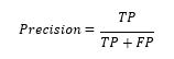
Recall
International Research Journal of Engineering and Technology (IRJET) e-ISSN: 2395-0056
Volume: 13 Issue: 03 | Mar 2026 www.irjet.net p-ISSN: 2395-0072
Measuresthesystem’sabilitytodetectallactualpotholes.
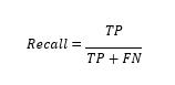
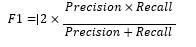
F1-Score
Providesabalancebetweenprecisionandrecall.
IntersectionoverUnion(IoU)
IoUisusedtomeasuretheoverlapbetweenpredictedandground-truthboundingboxes.AnIoUthresholdof0.5isused todeterminecorrectdetections.
G.ConfusionMatrixAnalysis
Aconfusionmatrixisgeneratedtoanalyzeclassificationperformance.Itprovidesaclearbreakdownofcorrectlyand incorrectlydetectedpotholes.
Actual/PredictedPotholeNo Pothole Pothole TP FN NoPothole FP TN
Hyperparametertuningisperformedtooptimizeearningrateandconfidencethresholds.Regularmonitoringoftraining andvalidationlossensurespreventionofoverfitting.
A. ExperimentAnalysis
TheproposedYOLOv4-Tinybasedpotholedetectionsystemwasevaluatedonatestdatasetconsistingofreal-world road images under varying environmental conditions. The performance of the model was measured using standard evaluationmetrics.
Table1:PerformanceMetrics
International Research Journal of Engineering and Technology (IRJET) e-ISSN: 2395-0056
Volume: 13 Issue: 03 | Mar 2026 www.irjet.net p-ISSN: 2395-0072
Actual / Predicted Pothole No Pothole Pothole 183(TP) 17(FN) NoPothole 14(FP) 186(TN)
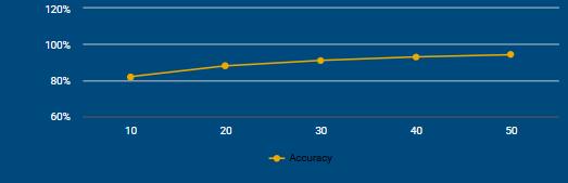
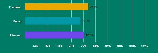
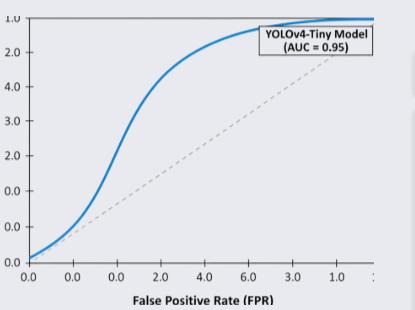
The results demonstrate that the proposed system achieves high detection accuracy while maintaining real-time performance.Theprecisionvalueindicatesthatthemodelproducesveryfewfalsedetections,whiletherecallshowsthat most potholes are successfully identified. The F1-score reflects a good balance between precision and recall, making the modelreliableforpracticaldeployment.TheIoU scoreconfirmsaccuratelocalizationofpotholes,andtheROC-AUCvalue indicatesstrongclassificationcapability.
International Research Journal of Engineering and Technology (IRJET) e-ISSN: 2395-0056
Volume: 13 Issue: 03 | Mar 2026 www.irjet.net p-ISSN: 2395-0072
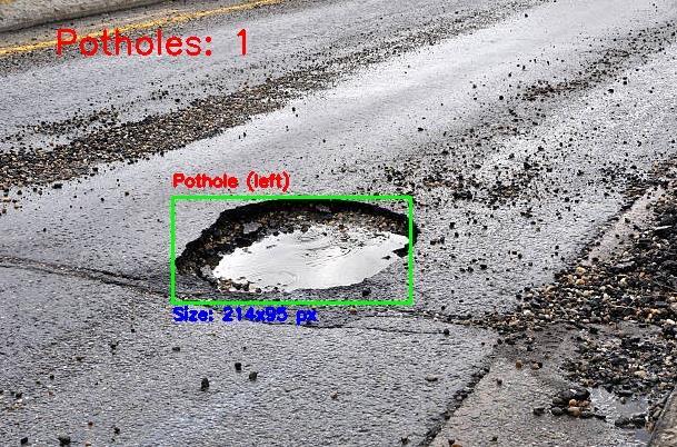
TheproposedYOLOv4-Tinybasedpotholedetectionsystemdemonstratesanefficientandreliablesolutionforautomated roadconditionmonitoring.Themodelachieveshighdetectionaccuracywhilemaintainingreal-timeperformance,making itsuitableforpracticaldeploymentinsmarttransportationsystems.Theexperimentalresults,asillustratedinFig1,Fig2, Fig3,confirmtheeffectivenessoftheproposedapproachinaccuratelydetectingpotholesundervaryingconditions.
[1] A. Mednis, G. Strazdins, R. Zviedris, G. Kanonirs, and L. Selavo, “Real Time Pothole Detection Using Android Smartphones with Accelerometers,” International Conference on Distributed Computing in Sensor Systems, Barcelona, Spain,2011.
[2] J.Eriksson, L. Girod, B. Hull, R. Newton, S. Madden, and H. Balakrishnan, “The Pothole Patrol: Using a Mobile Sensor Network for Road Surface Monitoring,” Proceedings of the 6th International Conference on Mobile Systems, Applications, and Services (MobiSys),pp.29–39,2008.
[3] K.RaviandS.Gupta,“AutomatedRoadConditionMonitoringUsingDeepLearningandSmartphoneSensors,” International Journal of Advanced Computer Science and Applications,vol.10,no.5,pp.200–207,2019.
[4] C. Kochand I. Brilakis, “PotholeDetectionin Asphalt Pavement Images,” Advanced Engineering Informatics, vol. 25, no.3,pp.507–515,2011.
[5] S.Khalid,T.Naseer,andM.Afzal,“ComputerVision-BasedPotholeDetection:AReviewofRecentApproaches,” IEEE Access,vol.8,pp.205980–205999,2020.
[6] O. Ronneberger, P. Fischer, and T. Brox, “U-Net: Convolutional Networks for Biomedical Image Segmentation,” Proceedings of the International Conference on Medical Image Computing and Computer-Assisted Intervention (MICCAI),pp. 234–241,2015.
[7] K. He, G. Gkioxari, P. Dollár, andR. Girshick, “Mask R-CNN,” Proceedings of the IEEE International Conference on Computer Vision (ICCV),pp.2961–2969,2017.
[8] K.R.Ahmed,“SmartPotholeDetectionUsingDeepLearningBasedonDilatedConvolution,” Sensors,vol.21,no.24,p. 8406,2021.
[9] S.Ren,K.He,R.Girshick,andJ.Sun,“FasterR-CNN:TowardsReal-TimeObjectDetectionwithRegionProposal Networks,” IEEE Transactions on Pattern Analysis and Machine Intelligence,vol.39,no.6,pp.1137–1149,2017.
[10] B. Varona, A. Monteserin, andA. Teyseyre, “A Deep Learning Approach toAutomatic Road Surface Monitoring
International Research Journal of Engineering and Technology (IRJET) e-ISSN: 2395-0056
Volume: 13 Issue: 03 | Mar 2026 www.irjet.net p-ISSN: 2395-0072
[11] V.Borkar,M.Joshi,andA.Vedak,“AComparativeStudyofObjectDetectionAlgorithmsforRoadAnomalies,” International Journal of Computer Applications,vol.174,no.12,pp.1–7,2021.
[12] A. Bochkovskiy, C. Y. Wang, and H. Y. M. Liao, “YOLOv4: Optimal Speed andAccuracyofObject Detection,” arXiv preprint arXiv:2004.10934,2020.
[13] J.RedmonandA.Farhadi,“YOLOv3:AnIncrementalImprovement,” arXiv preprint arXiv:1804.02767,2018.
[14] F.Montoya,A.Conde,andP.Ruiz,“Real-TimePotholeDetectionUsingEdgeAIandVideoProcessing,” IEEE Access, vol.10,pp.112345–112356,2022.
© 2026, IRJET | Impact Factor value: 8.315 | ISO 9001:2008 Certified Journal | Page1559 andPotholeDetection,” Personal and Ubiquitous Computing,vol.24,no.4,pp.519–534,2020.