
6 minute read
Water on a Small Island State: A Hydrological Tour of Malta


BY CHRISTOPHER MERCIECA, HIGHER NATIONAL DIPLOMA IN TOURIST GUIDING
Introduction
Though the concept of niche tourism remains a contested one, it is generally understood as a targeted tourism offering, with a particular segment of the market in mind, as opposed to a generic product designed for mass consumption (Robinson, Heitmann, & Dieke, 2011). Framed slightly differently, the process of creating a niche tourism product can be seen as an effort to design a product with the specific needs of customers in mind. As such, then, any tour specifically designed to the needs and interests of a particular group (as opposed to a mass consumption standardised tour, designed to have something to please everyone) can be said to constitute niche tourism.
This assignment follows a hypothetical case of a multinational group of hydrologists and environmental policymakers visiting Malta for a conference. It is designed to offer an entertaining and informative full-day experience on the side of the conference, exploring different periods of Malta’s general history as seen through the experience of water; a basic need necessary for human survival which is in short natural supply due to the islands’ arid climate.
The following sections provide some background information and justification for each of the potential stops on this tour. The itinerary of the tour itself is then presented at the end of the article
WIED BABU AND IL-MISQA
Wied Babu provides an ideal starting point to explain the geology of the Maltese Islands, on which the entire hydrological system depends. The Maltese Islands are composed of sedimentary rock, stratified into five main layers as shown below.
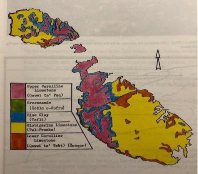
With the exception of Blue Clay, the other layers of rock are porous. This therefore allows the limited rainwater which falls on the islands to percolate through the rocks, until it reaches the mean sea level aquifer and its water table (Azzopardi, 1995).
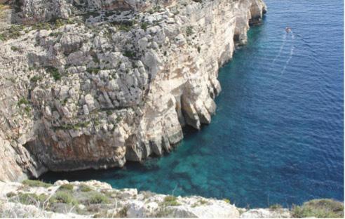
Wied Babu is a fine example of a river valley, formed by the passage of water over time which gradually wore away at the limestone. In this case, a deep ravine (also known as a gorge) was formed since the rock (mostly Lower Coralline Limestone) was relatively resistant and the speed of the stream rapid (Schembri, Lanfranco, Farrugia, Schembri, & Sultana, 1987). It thus offers an insight to a time when the Maltese climate was much wetter than today.
At the nearby Misqa Tanks, one can then observe some of the earliest known human interventions for the collection of rainwater in Malta. These are situated close to the megalithic sites of Mnajdra and Ħagar Qim and generally dated to the same Temple Period or shortly after it and consist of a group of rock-cut water cisterns which are fed by rainwater runoff from a rocky outcrop. They display an adaptation to life in the southern part of the island, which has relatively few springs (Stroud, 2015).
The Rabat Area
Moving on to the Rabat Uplands, one observes an entirely different water system. Since all five rock layers are present in this area, rainwater passes through the topmost rock strata until it reaches the impermeable Blue Clay layer. It then gathers above this to form a perched water table (Azzopardi, 1995).
Where a perched water table is present, places where the layer of Blue Clay is exposed lead to the formation of springs from which fresh water flows out unaided (Azzopardi, 1995). Many of these springs were enhanced in the past by the construction of rooms, such as the Knightsera structure at Għajn Ħamiem below the walls of Mdina. Its name probably originates from a corruption of the Arabic hammam meaning public bath (Zarb Dimech, 2016). The washhouse has several deep troughs and was likely a popular haunt of the residents of Mdina. Another spring is also to be found just a few meters away at Għajn Għeriexem.
The nearby Sentini Reservoir of Fiddien was constructed in the 1950s, with the aim of collecting water from yet another spring. On a stone building situated at the entrance to Fiddien valley, a plaque states in Latin that “this is a gauging chamber for the two 12 inch cast iron pipes taking water from a spring nearby on to the Sentini reservoir” (Borg, 2002 as cited in Hallett, 2015, pp. 47-48).
It is also important to point out that the Fiddien area feeds two major water systems which will be seen later on – Wied il-Qlejgħa (better known as Chadwick Lakes) and the Wignacourt Aqueduct.

Chadwick Lakes consists of a series of dams, named after Sir Oswald Chadwick, who oversaw their construction in 1886. Their function is to retain rainwater flowing down the Wied il-Qlejgħa valley, giving it time to percolate through the rock so as to replenish the aquifer. Besides this, water may of course also be drawn directly for irrigation and keeps the soil around the valley moist (Azzopardi, 1995).

The Wignacourt Aqueduct
The tour proceeds by driving towards Valletta, passing along the Wignacourt Aqueduct in Fleur-de-Lys and Ħamrun. Commissioned by Grand Master Alof de Wignacourt in the early 1600s and constructed by two engineers, Natale Masucci and Bontadino de Bontadini, the arched aqueducts form part of a large-scale project designed to bring freshwater from the Rabat-Dingli area to Valletta by gravity (Azzopardi, 1995). Water flowed through underground pipes for most of its length, with the arched sections traversing uneven depressions in the terrain. Notable features are the Fleur-de-Lys Gate, Tower of St. Joseph and Floriana water tower, amongst others.
Valletta
A brief walk into Valletta’s Parliament Square and a stop at the Omnibus Idem fountain gives a sense of completion to the drive along the Wignacourt Aqueduct. This fountain, whose inscription translates as the same to all, was originally located on the Knights’ Ferreria (where Palazzo ButtiġieġFrancia is now situated) and was moved several times before being placed in its current location during the recent City Gate Project (Malta Independent, 2011). It is only one of several fountains to have been installed by the Knights in Valletta and Floriana, following the successful completion of Wignacourt’s project.
To round up the Knights’ Period, it may be brought to the attention of the group at this point that in the Order of St. John’s initial evaluation of Malta, they found it arid and ill-suited to their needs, with its water described as “salty and putrid” (Sapiano, Micallef, Attard, & Zammit, 2008, p. 100). Yet just a few decades later, they had successfully transformed the islands, with Valletta having plentiful flowing water and in fact becoming one of the most advanced cities of its time.
As a transition to contemporary times, the view from the Upper Barrakka Gardens will offer a suitable backdrop for explaining the continued population growth, especially in the Harbour region, making

Malta one of the most densely populated countries in the world today. Despite the large-scale projects undertaken by the British such as those in Chadwick Lakes and a further upgrading of the Wignacourt Aqueduct system, post-independence Malta was plagued by water shortages.
Standing now in Castille Square, surrounded by the likes of Paul Boffa, George Borg Olivier and Dom Mintoff, the politicisation of water can be mentioned. The 1980s and 1990s in particular were characterised by water shortages, generally in regions of the island that tended to lean towards the party not in power and alternating with changes in Government (Vella, 2017). Water was so high on the political agenda that successive elections were contested primarily on water and energy issues, and protests were held across the islands such as one in which “hundreds of Vittoriosa residents vented their anger at years of water supply cuts…banging buckets and bottles and shouting ‘we want water’” (Calvert, 1993 as quoted in Vella, 2017, p. 103).
The Pembroke Reverse Osmosis Plant
Though energy issues remain high on the national political agenda today, the provision of water seems to have stabilised in the previous decades. This has been made possible in spite of a growing population largely due to reliance on Reverse Osmosis. The Maltese Islands are currently served by three large-scale Reverse Osmosis plants, in Pembroke, Ċirkewwa and Għar Lapsi. Together, these provide for approximately 58% of Malta’s water consumption (Water Services Corporation, n.d.). A fourth Reverse Osmosis plant is currently under construction in Gozo.
Conclusion
As this brief paper has shown, water quite literally permeates all layers of Malta’s history. Ever since the Temple Period, humans have been shaping the natural environment of the islands in order to collect water, from the Misqa Tanks right up to the 21st Century Reverse Osmosis plants. A hydrological tour of Malta thus offers a double benefit; it allows the guide to specifically target the group’s interests, yet still allows for a comprehensive overview of the major periods in the islands’ history.


