20 minute read
MASTER DEVELOPMENT PLANS & PLANNED UNIT DEVELOPMENTS


8.0270 Master Development Plans. A Master Development Plan is required as a condition of annexation, or after annexation, but prior to or concurrent with rezoning from Urban Holding-10 to other City zoning districts. The specific requirements for a Master Development Plan are:
1. Applicability. This section applies to properties proposed for annexation or rezoning from Urban Holding-10, except that in the event that an applicant has applied for a Planned Unit Development application prior to or concurrent with rezoning from Urban Holding-10, the Master Development Plan approval criteria shall be those used for the Planned Unit Development application and the Great Neighborhood Principles.
2. Purpose. The purpose of Master Development Plan is to provide:
A. Orderly and efficient development of the City consistent with the City of Redmond Framework Plan and adopted Area Plans.
B. Compatibility or transitions with adjacent developments and the character of the area.
C A complementary mix of uses and activities.
D. An interconnected transportation network (streets, bicycle routes, and pedestrian trails) within the master plan area and to existing and planned City streets, routes, and trails.
E. A range of housing choices and densities for areas planned to have residential components
F A range of open spaces and recreation facilities, as needed to facilitate the Framework Plan and an adopted Area Plan
G. Public and semi-public facilities and services.
H. Preservation of historic buildings, scenic views, and natural resources to the greatest extent possible
I. Transitions or buffers between urban development and rural areas.
J. Implementation of Redmond’s Comprehensive Plan, including adopted Area Plans and the Great Neighborhood Planning Principles described in 3(C)(13) below.
3. Procedures for Review
A. General. Master Development Plans (MDP or PMDP) shall be approved through a quasi-judicial review process. Application procedures and related fees for approval may be streamlined in order to promote timely development of urban planning for land zoned UH-10. The Community Development Director, or designee, shall inform the applicant during the mandatory pre-application stage if the proposed MDP area includes the necessary contiguous properties The determination for the proposed plan area shall be based on utilizing the following factors:
1. Whether there are properties that abut or are surrounded by the plan boundary that would reasonably fit within the zoning concept for the area plan;
2. Whether the extension of public services and infrastructure would be enhanced by the inclusion of abutting properties;
3. Whether the total acreage of abutting or enclave properties is less than the acreage in the proposed plan area; and
4. There is a community interest that would be served by including additional properties in the plan area.
B. Review and approval criteria for Master Development Plans (MPD) or Partial Master Development Plans (PMDP).
1. General. In the review of any application for a Master Development Plan, the Planning Commission and City Council, if required, shall consider the following: a. Whether the proposed Plan is generally consistent with the Framework Plan, adopted Area Plan, and Comprehensive Plan in terms of land use, density, transportation systems and networks, adequacy of infrastructure and open space. b. Whether the proposed Plan is generally suitable for the area in which it is proposed, considering existing and planned neighborhoods, shopping and employment areas, and natural resources and hazards. c. Whether the proposed Plan is functionally integrated with developed or planned areas. d. The proposed Plan meets the applicable Great Neighborhood Principles.
C. Master Development Plan (MDP) or Partial Master Development Plan (PMDP) Submittal Requirements and Approval Process.
An application for approval shall include the submittal requirements set forth in the City’s Land Use Review application form as well as the elements described below.
1. Narrative. A narrative shall set forth the goals and objectives of the plan and describe the urban characteristics of the planned area.
2. Neighborhood Meeting. Proof a neighborhood meeting was conducted to provide an opportunity for the applicant to meet with surrounding property owners discuss the proposal. See Section 8.0385 for meeting requirements.
3 Development Plan Map. A map of the plan area and surrounding vicinity shall indicate planned land uses for each land parcel in the area, including plans for park and open space and community facilities, if known. The plan shall show proposed comprehensive plan map designations and zoning. The plan shall include a list of all affected properties with tax lot numbers, current ownership, parcel size, and other information that is pertinent to the plan.
4 Land Use Diagram. The land use diagram shall generally indicate the distribution and location of planned land uses for the master plan area, including plans for park and open space and community facilities, if known. The plan shall show proposed comprehensive plan designations, zoning, and density.
5. Significant Resources Inventory. An inventory of significant natural resources, scenic and historic resources, and open space areas including those identified on the City’s adopted inventory and those that have the potential to qualify for protection under Redmond’s Goal 5 resource protection program. When significant resources are present, the proposed plan shall include a management plan to protect resource sites.
6. Parks and Open Space. Identify land suitable for park and recreation use in accordance with the needs analysis in the City of Redmond Park Master Plan (Park Plan) and an adopted Area Plan. In particular, where the Park Plan indicates there is a need for neighborhood or community park, the master plan shall identify sites that may be suitable for park development using the design and location criteria from the Park Plan or an adopted Area Plan. Density transfers, SDC credits, dedication, and other value consideration may be identified in the planning process to compensate property owners for land dedicated to public use.
7. Air, Noise, and Water Resources. Review air, noise and water resources that may be impacted by planned development and address how adverse impacts will be avoided or mitigated in compliance with applicable local, state, and federal regulations. The analysis may use City public facility plans, technical studies, and policies to meet this requirement when those plans address how urban development in the plan area can be served. In these instances, the Master Development Plan must show that the envisioned land uses in the plan area are consistent with the land use assumptions in the public facility plans. This requirement is particularly important for storm water management.
8. Natural Hazard Areas. Inventory areas subject to natural hazards, particularly steep slopes, and program urban development that is suitable for the identified hazard areas
9. Residential Uses. Identify areas planned for housing development, if any, and the proposed zoning districts to be applied. The housing plan must identify a mix of housing types and densities so that the overall density in the area meets or exceeds the housing density objectives for the area that are identified in the Redmond Urban Framework Plan, adopted Area Plans, and the Comprehensive Plan. The Framework Plan and adopted Area Plans provide general guidance on housing densities that need to be achieved in order to meet future housing needs. Where proposed residential land uses differ from those shown in the Redmond Urban Framework Plan or adopted Area Plans, the master plan shall demonstrate how it meets the overall housing objectives of the Redmond Urban Framework Plan or adopted Area Plans. Applicants may propose new zoning districts when the proposed district(s) in total achieve the housing densities envisioned in the Redmond Urban Framework Plan or adopted Area Plans.
10 Employment Uses. Identify areas planned for employment use and/or mixed uses and the proposed zoning for these areas. Applicants may propose new zoning districts in cases where existing districts are not suitable for the planned development provided the proposed district(s) achieve similar land improvement values and/or employment densities envisioned in the Redmond Urban Framework Plan or adopted Area Plans.
11 Transportation Analysis and Diagram. Prepare a Transportation Impact Analysis (TIA) including a grid street plan that is consistent with street spacing and connectivity guidelines in the Redmond Transportation System Plan (TSP) and adopted Area or Framework Plans. The TIA shall identify and show: a. The proposed classification for all streets. b. The location of approved TSP improvement projects. c. Any capital improvements that may need to be added to the TSP in order to serve the plan area. d. Proposed bicycle pedestrian, and trail routes. e Demonstrate how planned transportation facilities will connect to transportation facilities in adjacent urban areas.
12. Public Facilities Analysis and Diagram. The plan shall include a conceptual layout of public facilities, (including sanitary sewer, water, and storm drainage) needed to support the planned uses. The Public Facilities Analysis must be consistent with the city’s adopted Public Facility Plan (PFP) and related facility master plans, including improvements related to the adopted Area Plan that may require amending the PFP.
13. North Redmond US 97 Interchange Area Management Plan (IAMP) Compliance. The master plan shall comply with the following policies, if applicable: a. Any property newly annexed within the IAMP area shall have: i. Direct Access to a local public street other than a state highway consistent with the Local Street Connectivity Plan; and, ii. Any property to be annexed to the City shall relinquish all direct access rights to a state highway as a condition of development approval (when a legal alternative access exists). a Transportation. Connect people and places through a complete grid street network and trail system that invites walking and bicycling and provides convenient access to parks, schools, neighborhood service centers, and possible future transit stops. Traffic calming techniques and devices may be required to slow vehicles. Curved streets are encouraged to provide interest and variety in neighborhood design. Trails shall be provided to link with existing or planned pedestrian facilities b Housing. A mix of housing unit types and densities shall be integrated into the design of new neighborhoods consistent with zone requirements unless a variance or other planning permit is approved Housing developments containing more than five attached units must be designed to be consistent with the Higher Density Multifamily Design Guidelines. c Open spaces, greenways, recreation All new neighborhoods shall provide useable open spaces with recreation amenities that are integrated to the larger community. Central parks and plazas shall be used to create public gathering places and should be located in or near the center of the project to the extent practicable. New neighborhoods should retain and incorporate significant geological features such as rock outcroppings or stands of clustered native trees into the design and lot layout. Neighborhood and community parks shall be developed in locations consistent with the Redmond’s Parks Master Plan. d. Integrated design elements. Streets, civic spaces, signage, and architecture shall be coordinated to establish a coherent and distinct character for the MDP MDPs may integrate design themes with adjacent developed or planned areas. e. Diverse mix of activities. A variety of uses are encouraged in order to create vitality and bring many activities of daily living within walking and biking distance or a short drive of homes. Amenities including, but not limited to, trails, recreation areas, and open spaces, shall be constructed before occupancy of any residential unit, unless a phasing plan is approved. Commercial service areas must be supported by a market analysis and phasing program which will be used by the City to determine construction timing. f. Public art or artistic feature. Places for the installation of public art or artistic feature is required to provide focal points, preferably, at the gateways to neighborhoods, in and around the center of neighborhoods, or trailheads. g. Scenic views. Identify and preserve scenic views and corridors of the Cascade Range, Ochoco Mountains, and Smith Rock, such as in street view sheds or park areas. Streets and common, or public, open spaces should be located and oriented to capture and preserve scenic views for the public. Minimize visual clutter from signs and utilities within scenic corridors. h Urban – rural interface. Urban development shall interface with rural areas through landscaped open space buffers at least 100 feet wide and the length of the urban development, excluding public streets, or shall be transitioned from higher density development to lower density development at the urban - rural interface i Pocket parks/tot lots. Fully developed “pocket parks” or “tot lots” shall be incorporated into medium and high density zoned residential subdivisions and site plans. These areas shall be developed for every twenty-five lots/units, a minimum of 3,000 square feet and privately maintained. Examples of amenities include: turf areas, benches, deciduous shade trees, irrigation, shrubs, natural or decorative features, and adequate trash receptable(s) and lighting j Canal trails. If canals or laterals are present, multi-use trails at least 10 feet wide shall be provided, subject to the Central Oregon Irrigation District’s review and approval. Pedestrian amenities such as benches and trash receptacles shall be provided at appropriate locations (e.g., every 500 feet, at trailheads or intersections with public streets) k. Green Design. Energy-efficient design through solar access setbacks, xeriscaping, and planting of drought-resistant trees to minimize water usage and provide shade.
14 Great Neighborhood Principles. MDPs shall address applicable Great Neighborhood Principles below. In instances where the property proposed for a MDP is located within the boundary of an adopted Area Plan, the MDP shall also address the Great Neighborhood Principles according to the specificity provided in the Area Plan.
D. Implementation. Upon approval, all subsequent development located within the MDP boundaries shall be consistent with the approval.
E. Amendment/Modification to Master Development Plan. Any modifications to the approved MDP shall be subject to the standards and procedures in Article II, “Modifications”, and subject to the review criteria contained in this section.
F Expiration of Master Development Plan. An approved MDP or PMDP shall be subject to the requirements of Section 8.1605 concerning expiration, unless a specific timeline is approved through the land use review process.
[Section 8.0270 added by Ord. #2022-04 passed June 28, 2022]
[Section 8.0270 amended by Ord. #2022-09 passed December 13, 2022]
8.0275 Planned Unit Development (PUD).
1. Purpose and Applicability. The purpose of a PUD is to:
A. Permit greater flexibility in land use regulations in all zones (e.g., reduction of minimum lot size requirements).
B. Encourage creative developments.
C. Incentivize a variety of land uses and housing types, mixed use, the economy of shared services and facilities, public amenities, and developments compatible with the surrounding area and neighborhoods.
D. Promote and encourage infill development, flexibility in improvements on lots, and affordable and workforce housing.
E. Encourage preservation of natural features and enhancement of the area vegetation
F. Facilitate sustainable design, energy efficiency, desirable aesthetics, and efficient use of open space.
Density requirements, setbacks, land use regulations, and required improvements may be adjusted to allow for a more creative, functional, and desirable living environment In return for greater flexibility in site design and development, the PUD process introduces special requirements and standards for approval.
2. Approval. PUD approval is subject to:
A. Land use review and approval as Conditional Use
B. Zoning standards, except as modified by the PUD.
C. Subdivision and Partitions Standards, except as modified by the PUD.
D. Site and Design Review Standards, except as modified by the PUD.
E. PUD Standards and Requirements.
3. Exceptions. Exceptions of City standards may be allowed through the PUD approval process without a variance
A. Exceptions shall substantially result in improved design of the PUD. Improved design includes but is not limited to: alleys; public or private parks, trails, recreational areas, open spaces, common or natural areas; innovative housing design; public or private activity areas; a mixture of housing types, sizes, and projected prices; energy efficient design; a variety of trees and landscaping; art and other similar design features. A PUD need not include all of these design features in order to be approved.
B. Exceptions to City standards include, but are not limited to:
1. Minimum lot sizes.
2. Setbacks.
3. Permitted land uses.
4. Grid street spacing standards.
5. Connecting to public utilities, subject to acceptance by City Engineer.
6. Street frontage, street and right-of-way width, sidewalk placement and standards, subject to acceptance by City Engineer.
7. Landscaping
8. Fences and walls.
4. Standards and Requirements. The following standards and requirements apply to a PUD application:
A. PUDs must be a minimum of one (1) acre in size. In the Downtown Urban Renewal District, a minimum of a half (0.5) acre in size.
B. The applicant shall submit a written narrative that addresses the applicable standards, code, and regulations.
C. A PUD approach may be utilized in the design and development of residential, mixed use, or commercial and industrial service areas.
D. Densities. Maximum densities are identified in Table 8.0140. Additional density (i.e., bonus density) beyond the maximum density will be considered as follows:
1. Up to 20% beyond maximum densities for qualified Affordable Housing and Workforce Housing units. A bonus density request beyond 10% shall be restricted to Affordable Housing. Affordable and Workforce Housing units should be designed to be intermixed throughout the development and similar design and quality to market rate units.
2. Up to 10% beyond maximum densities for including amenities that provide a community benefit or helps realize specified public policy goals. Examples include: additional protection of green space, recreational areas, open space, natural resources or view corridors environmental improvements, trail connectivity, higher quality building design, or other additional amenities.
3 As identified in respective Area Plans
E A PUD must include usable open space, recreational area, common area or park designed for the use and benefit of all the units or lots in the development. The land area used shall be determined by the type of amenities added by the developer. See examples below:
F Thoughtful design and architectural themes are required for all structures within any development. Design shall take into consideration themes continues on all elevations for each building, and onto the entire site including, but not limited to: lighting, fencing, accessory structures, signage, and trash enclosures.
G. A separate application or rezoning may accompany the application for approval of the PUD in which case the two items shall be considered simultaneously.

H. The City may recommend a performance bond or other surety to assure the proposed development will be completed as approved and within the time limits agreed to in the conditions of approval.
5 Review Procedure for PUD’s. The following procedure shall be followed in requesting approval of a PUD.
A. A pre-development meeting is required prior to submittal of an application.
B. Proof a neighborhood meeting was conducted for residential or mixed-used development proposals that generate 200 or more daily trip ends, or 20 or more p.m. peak hour trip ends, where a Transportation Impact Analysis (TIA) is required, See Section 8.0385 for meeting requirements.
C. An applicant shall submit an electronic version of the complete application. The plan shall contain and show, at an engineer’s scale of no less than 1” =10’, the following information:
1. The relationship of the property to the surrounding area.
2. The preliminary plan of subdivision or re-subdivision, if any, which shall include the information required by the Subdivision Ordinance.
3. Land uses, building locations, density proposed, architectural style, efficiency measures, housing market served, and number of dwelling units.
4. The arrangement of streets and pedestrian ways.
5 Proposals that include reduced yards and lot size shall be designed to be served by private alleys or drives.
6 The location of off-street parking spaces, and a parking management plan if the total number of spaces required exceeds 75.
7 The location of service commercial areas, open space, recreational area, common areas, or park
8 Plans for site grading and drainage.
9 Plans for water supply and sewage disposal.
10 Plans for transfer of ownership of the property, if any, and arrangements for maintenance of common areas and facilities.
11 Landscape plan including the list of species proposed and size/coverage at time of planting and at five years.
12 Proposed project timing schedule and surety, if required by City.
D In considering the PUD, the City shall determine:
1. There are special development objectives or physical conditions which justify a request for a PUD.
2. The PUD will contain buffers on sides of the development that abut neighboring properties
3. The PUD, through its design and function, will improve livability for planned residents.
4. The PUD contains a mix of housing types, variety of uses or services.
5. The PUD can be completed within 5 years or phased for later development.
6. The PUD will not overload adjacent streets, utilities, or infrastructure
7. The PUD will be consistent with the objectives of Area Plans and the Redmond Comprehensive Plan.
E. The City Shall notify the applicant whether in its judgment the foregoing provisions have been satisfied and, if not, whether they can be satisfied with other alternatives or revision to the PUD.
6. PUD Post Approval & Modifications. Where a PUD has been authorized pursuant to applicable zoning regulations, the plan of the subdivision shall conform with the plan of the PUD as approved.
Minor Modification – Minor modification to an approval PUD will be granted when the requested change is so minor that the CDD Director, or designee, determines that it would be appropriate for an administrative decision. Examples of minor changes include, but are not limited to: (1) a reduction in the overall number of lots, (2) minor architectural changes to approved buildings, (3) changes to phases that do no impact public facilities or change the number of approved phases, (4) changes that result in a reduction of impacts (i.e., reduced traffic flows), or (5) changes that are required to protect or increase public safety.
Major Modification - Major modifications to an approved PUD are subject to Section 8.1400.
[Section 8.0275 amended by Ord. #2016-17 passed January 31, 2017]
[Section 8.0275 amended by Ord. #2018-09 passed September 11, 2018]
[Section 8.0275 amended by Ord. #2020-15 passed November 10, 2020]
[Section 8.0275 amended by Ord. #2022-04 passed June 28, 2022]
[Section 8.0275 amended by Ord. #2022-09 passed December 13, 2022]
8.0280
Cluster Developments.
[Section 8.0280 amended by Ord. #2016-17 passed January 31, 2017]
[Section 8.0280 amended by Ord. #2017-12 passed December 12, 2017]
[Section 8.0280 amended by Ord. #2018-09 passed September 11, 2018]
[Section 8.0280 amended by Ord. #2020-15 passed November 10, 2020]
[Section 8.0280 deleted by Ord. #2022-04 passed June 28, 2022]
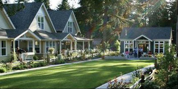
8.0285 Cottage Developments.
1. The purpose of a Cottage Development (COD) is as follows:
A. To provide a greater flexibility in development of land on sites that may be too small or not desirable for a Planned Unit Development;
B. To provide housing types that respond to changing household sizes and ages (e.g., retirees, single person households, small families);
C. To provide opportunities for ownership of dwelling units;
D. To encourage a creative approach in land development and for a consistent and interesting architectural theme within each development;
E. To encourage creation of more usable open space for residents of the development through flexibility in density and lot standards; and,
F. To provide guidelines to ensure compatibility with surrounding land uses.
2. Throughout section 8.0285, the term “Development” shall mean a Cottage Development (COD).
3. The uses shown in 8.0285 (Table 8c) are permitted in a residential Cottage Development.
Table 8c. Uses Permitted. The following uses are permitted in Cottage Developments:
Land Use
Comments & References
Accessory Structure Includes ADU's, sheds, storage buildings, residential garages.
Dwelling, Single Family Park (public or private) e.g., playgrounds, recreation centers, pools, etc.
4. The following exceptions to City standards may be allowed through the COD approval process without a variance:
A. Minimum lot sizes.
B. Yard setbacks, except perimeter yard requirements.
C. Permitted land uses
D. Grid street spacing standards.
E. Street frontage requirements on public roads.
F. Connection to public utilities, subject to review and acceptance by City Engineering.
G. Landscaping requirements, as stated herein.
H. Solar setback standards (only on lots that are not along the northern border of the development).
I. Street and right of way widths on non-grid streets.
J. Sidewalk placement and size standards.
K. Changes to an approved Plan, when the requested change is so minor that the CDD Director or designate determines that it would be appropriate for an administrative decision. Examples of minor changes include, but are not limited to: (1) a reduction in the overall number of lots, (2) minor architectural changes to approved buildings, (3) changes to phases that do not impact public facilities or change the number of approved phases, (4) changes that result in a reduction of impacts (i.e., reduced traffic flows), or (5) changes that are required to protect or increase public safety.
5. Development Standards. CODs shall meet the following Standards unless otherwise specified. In the case that these standards conflict with other standards within Article I, III, or IV of the Redmond Development Code, these standards shall take precedence:
A. Cottage Developments (CODs) have no minimum site size but must include a minimum of 4 cottage units per development.
B. Densities
C. Design Requirements
Floor Area Average of 1000 square feet not to exceed 1250 square feet per unit excluding garage. 400 square feet car garages only, no RV garages.
Open Space 800 square feet per each dwelling unit.
Setbacks 6
Perimeter
20’ when abutting an arterial or collector street (along perimeter), underlying zone in all other cases; Setbacks to common areas determined at the discretion of the Hearings Body.
Front No minimum
Side (corner lot) No minimum, but 10’ required between buildings.
Side (non-corner lot) No minimum, but 10’ required between buildings.
Rear No minimum, but 10‘required between buildings.
Solar Northern perimeter only
Non-permeable surface area 60% of parent property (maximum)
Building coverage 50% of parent property (maximum)
Parking
Residential
1.75 spaces / cottage d.u.
6 Setbacks listed are the minimum required. Setbacks are measured from foundation of any building requiring a building permit to the nearest property line. Foundation includes anchors for posts/supports where structurally related.
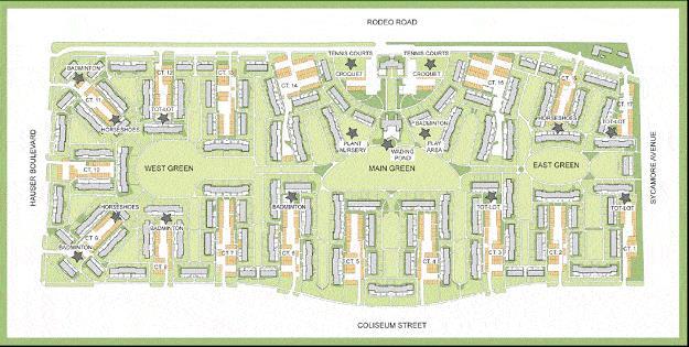
D. Open Space, Park, and Common Area.
1. “Open space” means land area which can be physically accessed and used by occupants and users of the COD for scenic, landscaping, or open recreational purposes within the development.
2. Open Space Land Area Requirements: For all CODs, the required land area7 used as open space or common area shall: a. Be a minimum of 800 square feet per cottage. b. Have at least one centrally located open space or common area at least 60 feet wide, within the development. c. At least 60% of the cottages must abut on at least two sides of open space or common area d. In addition to the centrally located open space, a series of interconnected open spaces are also allowed, but the connections between open spaces shall not contribute toward meeting the open space area and be a minimum of 20 feet wide
3. Cottage Orientation Requirements: a. Cottages abutting the common open space shall be oriented around and have the main entry taken from the common open space b. Cottages not abutting the common open space shall be within 60 feet walking distance from the common open space and served with paths. c. The open space shall be distinguished from the private outdoor areas with a walkway, fencing (not to exceed four feet in height), landscaping, berm, or similar method to provide a visual boundary around the perimeter of the common area. a. Public and private roads shall not be considered as open space. b. Development plans shall assure that natural features of the land are preserved, and landscaping is provided, or a finding shall be made by the Hearings Body that preservation of significant natural feature(s) is not feasible. c. Parking areas shall not exceed four spaces and shall be separated from other parking areas by a distance of 20 feet. d. Up to 10% of the required open space / common area / landscaped areas may be left in a natural and non-irrigated state at the discretion of the Hearings Body; however, this shall not apply to any required landscaped screening or landscaped strips abutting public or private roads. If the development has a significant natural feature in excess of the 10% allowance, the Hearings Body may allow additional natural feature open space credit e. Open space, common areas, and common structures shall be financially assured of continued maintenance. A legal mechanism shall be provided which guarantees the continued maintenance of such areas and structures. a. All Development parking lots shall be screened from view from public or private streets (excluding driveways of 20’ width or less), and from all residences by a screen of no less than 3’ in height. Screening shall not exceed a height of 4’. b. Parking lot screening shall be achieved by either landscaping or fencing, or a combination of each. c. All parking spaces shall be paved and shall meet the parking space standards within sections 8.0500 -.0515 of the RDC, and all applicable code standards. d. If detached parking structures are proposed, the following shall apply: i. Pitched roofs are required on all parking structures and shall be no less than a 4:12 pitch. ii. Paint color and building materials shall be consistent with the design of the dwelling closest to the structure. e. Usable Open Space. All required open space within any planned development shall be ‘usable’ as passive or active recreational land without sharing the space as a combined use with nonrecreational uses, including (but not limited to) drainage retention. f. Yards. Private open space shall be a minimum of 300 square feet of private, contiguous, usable open space adjacent to each dwelling unit, for the exclusive use of the cottage resident. g. Porches/Patios: Cottages shall have a minimum of 10% of floor area S.F. as a roofed porch or patio combination. Porches are not included within floor area calculations. h. Required Parking Distance from Cottages. All required parking for Cottage Developments shall be located within 100 feet of the cottage that it serves.
4. Open Space – General Requirements.
5 General Development Design Requirements.