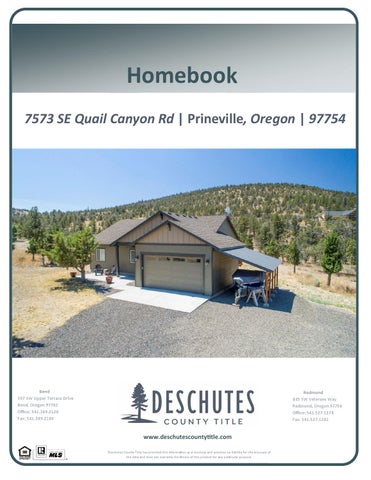
Homebook 7573 SE Quail Canyon Rd | Prineville, Oregon | 97754
Bend 397 SW Upper Terrace Drive Bend, Oregon 97702 Office: 541.389.2120 Fax: 541.389.2180
Redmond 845 SW Veterans Way Redmond, Oregon 97756 Office: 541.527.1274 Fax: 541.527.1281
www.deschutescountyƟtle.com Deschutes County Title has provided this informa on as a courtesy and assumes no liability for the accuracy of the data and does not warranty the fitness of this product for any par cular purpose.
Guest Sign-in NAME
ADDRESS
PHONE
GUIDE TO CLOSING COSTS *Customary for Seller to Pay Type of Financing Real Estate Agent Commissions Reconveyance/Release Fees Prepayment Penalties (If Applicable) Owner's Title Insurance Escrow Fee Tax Prorations Lien Search (if applicable) Mortgages & Encumbrances Any Property Tax Due
Conventional
FHA
VA
● ● ● ● ● ● ● ● ●
● ● ● ● ● ● ● ● ● ●
● ● ● ●
Buyer's Lender Fees (varies by lender)
● ● ● ● ●
Cash (no loan)
● ● ● ● ● ● ● ● ●
*Customary for Buyer to Pay Type of Financing Appraisal Fee Loan Origination Fee/Discount Credit Fee Mortgage Insurance (if applicable) Reserve Set Up Fee (if apllicable) Fire Insurance 1 year (home owners policy) Flood insurance (if applicable) Flood and Tax Certifications Prepaid Interest Home Owners Association Fees (if applicable)
Conventional
FHA
VA
● ● ● ● ● ● ● ● ● ●
● ● ● ● ● ● ● ● ● ●
● ● ●
● ● ● ●
● ● ● ●
VA Funding Fee Recording Fee Tax Proration Escrow Fee Lenders Title Insurance
* Items listed are intended to represent only what may be customarily charged and may not reflect actual charges at closing. Consult with your real estate professional or title company representtaive for actual charges specific to your transaction. Seller to pay full escrow fee (includes buyer escrow fee)
● ● ● ● ● ● ● ● ● ●
Cash (no loan)
● ● ● ●
Crook County Parcel Information
Parcel Information Parcel #: 10027 Tax Account: 151629D001200 Site Address: 7573 SE Quail Canyon Rd Prineville OR 97754 Owner: Allen, Luke Allen, Melissa PO Box 130 Camp Sherman OR 97730 Twn/Range/Section: 15S / 16E / 29 / SE Parcel Size: 1.03 Acres (44,867 SqFt) Plat/Subdivision: Highlands Legal Lot/Block: 68 / 0 Census Tract/Block: 950400 / 1074 Levy Code: 12 Levy Rate: 13.1781 Levy Year: 2019 Market Land Value: $64,190.00 Market Impr Value: $170,960.00 Market Total Value: $235,150.00 (2019) Assd Total Value: $157,616.00 (2019)
Tax Information Tax Year 2019 2018 2017
Annual Tax $2,077.08 $2,024.21 $1,991.96
Legal Highlands Lot: 68, Township: 15S, Range: 16E, Section: 29
Land Land Use: # Dwellings: Primary School: High School:
101 - Res Improved 1 Crooked River Elementary School Crook County High School
Zoning: RRM5 - Recreational Residential School District: Crooked River School District Middle School: Crook County Middle School
Improvement Year Built: Bathrooms, Full: Floor 1: Carport: Condition:
2016 2 1,192 SqFt
Bedrooms: 3 Bathrooms, Half: Floor 2: Attic:
Bathrooms, Total: 2.00 Finished Area: 1,192 SqFt Garage: 400 SqFt Basement:
AV
Transfer Information Rec. Date: 6/30/2017 Owner: Luke Allen Orig. Loan Amt: $254,308.00 Finance Type:
Sale Price: $259,000.00
Loan Type: FHA
Doc Num: 281236 Grantor: Title Co: AMERITITLE Lender: GUILD MTG CO
Doc Type: Deed
Sentry Dynamics, Inc. and its customers make no representations, warranties or conditions, express or implied, as to the accuracy or completeness of information contained in this report.
Crook County Property Summary Report Report Date: 7/29/2020 8:23:40 AM
Disclaimer The information and maps presented in this report are provided for your convenience. Every reasonable effort has been made to assure the accuracy of the data and associated maps. Crook County makes no warranty, representation or guarantee as to the content, sequence, accuracy, timeliness or completeness of any of the data provided herein. Crook County explicitly disclaims any representations and warranties, including, without limitation, the implied warranties of merchantability and fitness for a particular purpose. Crook County shall assume no liability for any errors, omissions, or inaccuracies in the information provided regardless of how caused. Crook County assumes no liability for any decisions made or actions taken or not taken by the user of this information or data furnished hereunder.
Account Summary Account Information
Ownership
Mailing Name:
Mailing Address:
ALLEN LUKE & MELISSA
Map and Taxlot: 151629D0-01200-10027
ALLEN LUKE & MELISSA
Account:
10027
PO BOX 130
Tax Status:
Taxable 7573 SE QUAIL CANYON RD PRINEVILLE, OR 97754
CAMP SHERMAN, OR 97730
Situs Address:
Valuation Real Market Values as of Jan. 1,
Property Taxes Current Tax Year: 2019 Tax Code Area:
12
Assessment
Land
$64,190
Structures
$170,960
Total
$235,150
Subdivision: HIGHLANDS SUBDIVISION
Current Assessed Values:
Lot:
Maximum Assessed
$157,616
Assessed Value
$157,616
Veterans Exemption
$0.00
68
Block: 0 Assessor Acres: Property Class:
101
Warnings, Notations, and Special Assessments
Valuation History All values are as of January 1 of each year. Real Market Value - Land Real Market Value - Structures Total Real Market Value Maximum Assessed Value Total Assessed Value Exemption Value
Property Information Report, page 1
Tax year is July 1st through June 30th of each year.
2015 - 2016 $9,900 $0 $9,900
2016 - 2017 $42,750 $50,290 $93,040
2017 - 2018 $50,000 $146,930 $196,930
2018 - 2019 $55,750 $158,210 $213,960
2019 - 2020 $64,190 $170,960 $235,150
$8,991 $8,991 $0
$76,880 $76,880 $0
$148,568 $148,568 $0
$153,025 $153,025 $0
$157,616 $157,616 $0
Tax Payment History Year
Date Due
Transaction Type
Transaction Date
As Of Date
Amount Received
Tax Due
Discount Amount
Interest Charged
Refund Interest
2019
11/15/2019
IMPOSED
11/15/2019
11/15/2019
$0.00
$2,077.08
$0.00
$0.00
$0.00
2019
11/15/2019
PAYMENT
11/14/2019
11/15/2019
$2,014.77 Total:
($2,077.08) $0.00
$62.31
$0.00
$0.00
2018
11/15/2018
2018
11/15/2018
IMPOSED
11/15/2018
11/15/2018
$0.00
$2,024.21
$0.00
$0.00
$0.00
PAYMENT
11/14/2018
11/15/2018
$1,963.48 Total:
($2,024.21) $0.00
$60.73
$0.00
$0.00
2017
11/15/2017
2017
11/15/2017
IMPOSED
11/15/2017
11/15/2017
$0.00
$1,991.96
$0.00
$0.00
$0.00
PAYMENT
11/14/2017
11/15/2017
$1,932.20 Total:
($1,991.96) $0.00
$59.76
$0.00
$0.00
2016
11/15/2016
PAYMENT
11/15/2016
11/15/2016
$983.54
($1,013.96)
$30.42
$0.00
$0.00
2016
11/15/2016
IMPOSED
11/15/2016
11/15/2016
$0.00 Total:
$1,013.96 $0.00
$0.00
$0.00
$0.00
2015
11/15/2015
IMPOSED
11/15/2015
11/15/2015
$0.00
$116.92
$0.00
$0.00
$0.00
2015
11/15/2015
PAYMENT
11/13/2015
11/15/2015
$113.41 Total:
($116.92) $0.00
$3.51
$0.00
$0.00
2014
11/15/2014
PAYMENT
05/15/2015
11/15/2014
$32.85
($32.85)
$0.00
$0.00
$0.00
2014
11/15/2014
PAYMENT
02/17/2015
11/15/2014
$31.49
($31.49)
$0.00
$0.00
$0.00
2014
11/15/2014
PAYMENT
11/17/2014
11/15/2014
$34.22
($34.22)
$0.00
$0.00
$0.00
2014
11/15/2014
IMPOSED
11/15/2014
11/15/2014
$0.00 Total:
$98.56 $0.00
$0.00
$0.00
$0.00
2013
11/15/2013
PAYMENT
05/13/2014
11/15/2013
$25.95
($25.95)
$0.00
$0.00
$0.00
2013
11/15/2013
PAYMENT
02/19/2014
11/15/2013
$25.95
($25.95)
$0.00
$0.00
$0.00
2013
11/15/2013
PAYMENT
11/20/2013
11/15/2013
$25.96
($25.96)
$0.00
$0.00
$0.00
2013
11/15/2013
IMPOSED
11/15/2013
11/15/2013
$0.00 Total:
$77.86 $0.00
$0.00
$0.00
$0.00
2012
11/15/2012
PAYMENT
05/17/2013
11/15/2012
$38.13
($38.13)
$0.00
$0.00
$0.00
2012
11/15/2012
PAYMENT
02/04/2013
11/15/2012
$38.13
($38.13)
$0.00
$0.00
$0.00
Property Information Report, page 2 (For Report Disclaimer see page 1)
Year
Date Due
Transaction Type
Transaction Date
As Of Date
Amount Received
Tax Due
Discount Amount
Interest Charged
Refund Interest
2012
11/15/2012
PAYMENT
11/21/2012
11/15/2012
$38.12
($38.12)
$0.00
$0.00
$0.00
2012
11/15/2012
IMPOSED
11/15/2012
11/15/2012
$0.00 Total:
$114.38 $0.00
$0.00
$0.00
$0.00
2011
11/15/2011
PAYMENT
05/14/2012
11/15/2011
$37.57
($37.57)
$0.00
$0.00
$0.00
2011 2011
11/15/2011
PAYMENT
02/15/2012
11/15/2011
$37.57
($37.57)
$0.00
$0.00
$0.00
11/15/2011
PAYMENT
11/18/2011
11/15/2011
$37.58
($37.58)
$0.00
$0.00
$0.00
2011
11/15/2011
IMPOSED
11/15/2011
11/15/2011
$0.00 Total:
$112.72 $0.00
$0.00
$0.00
$0.00
2010
11/15/2010
PAYMENT
05/16/2011
11/15/2010
$36.30
($36.30)
$0.00
$0.00
$0.00
2010
11/15/2010
PAYMENT
02/09/2011
11/15/2010
$36.30
($36.30)
$0.00
$0.00
$0.00
2010
11/15/2010
IMPOSED
11/15/2010
11/15/2010
$0.00
$108.89
$0.00
$0.00
$0.00
2010
11/15/2010
PAYMENT
11/12/2010
11/15/2010
$36.29 Total:
($36.29) $0.00
$0.00
$0.00
$0.00
2009
11/15/2009
PAYMENT
04/26/2010
11/15/2009
$35.19
($35.19)
$0.00
$0.00
$0.00
2009
11/15/2009
PAYMENT
02/16/2010
11/15/2009
$35.19
($35.19)
$0.00
$0.00
$0.00
2009
11/15/2009
PAYMENT
11/20/2009
11/15/2009
$35.18
($35.18)
$0.00
$0.00
$0.00
2009
11/15/2009
IMPOSED
11/15/2009
11/15/2009
$0.00 Total:
$105.56 $0.00
$0.00
$0.00
$0.00
2008
11/15/2008
PAYMENT
11/18/2008
11/15/2008
$101.77
($104.92)
$3.15
$0.00
$0.00
2008
11/15/2008
IMPOSED
11/15/2008
11/15/2008
$0.00 Total:
$104.92 $0.00
$0.00
$0.00
$0.00
2007
11/15/2007
PAYMENT
11/21/2007
11/15/2007
$95.69
($98.65)
$2.96
$0.00
$0.00
2007
11/15/2007
IMPOSED
11/15/2007
11/15/2007
$0.00 Total:
$98.65 $0.00
$0.00
$0.00
$0.00
Sales History Sale Date Seller
Buyer
Sale Amount
12/16/1998
HIGHLANDS SUBD WATER DISTRICT MOLONY, DAVE
$70,000
07/30/2015
MOLONY DAVE
MENNING CAROL
$30,500
06/30/2017
MENNING CAROL
ALLEN LUKE
$259,000
Sale Type WARRANTY DEED STATUTORY WARRANTY DEED STATUTORY WARRANTY DEED
Recording 145545 269575 281236
Structures Stat Class/Description
Improvement Description
31 Grade 3 - : DWELL
DWELL
Code Area
Year Built
Eff Year Built
Total Sq Ft
12
2016
2016
1192
Land Characteristics Land Description
Acres
19 - 1ST OSD
0.00
13 - Market
0.00
18 - Yard Improvements
0.00
Land Classification
Related Accounts Related accounts apply to a property that may be on one map and tax lot but due to billing have more than one account. This occurs when a property is in multiple tax code areas. In other cases there may be business personal property or a manufactured home on this property that is not in the same ownership as the land.
No Related Accounts found. Property Information Report, page 3 (For Report Disclaimer see page 1)
Ownership Name Type
Name
Taxpayer
ALLEN LUKE & MELISSA
Owner
ALLEN LUKE
Owner
ALLEN MELISSA
Ownership Type , ,
Percentage 100.00% 100.00%
,
100.00%
300.00%
Property Information Report, page 4 (For Report Disclaimer see page 1)
Grade - 31 Grade 3 Foundation - Concrete or block Siding - Hardboard
Roof Type - Gable
Effective Year - 2016 Heating - Wall units
Roof Cover - Comp shingle heavy
Cooling - None
1,192
1
of
2
7/29/2020 8:27:22 AM
Water Heaters- 1 Kitchen Sinks - 1
Grade 3+
Year Built 2016
Percent Complete 100
Effective Year 2016
Percent Good 100
Features Concrete floor Electric lights & service Roof comp shingle heavy
2
of
2
7/29/2020 8:27:22 AM
Property Information Report, page 5 (For Report Disclaimer see page 1)
★
ParcelID: 10027 7573 SE Quail Canyon Rd Prineville, OR 97754 This map/plat is being furnished as an aid in locating the herein described land in relation to adjoining streets, natural boundaries and other land, and is not a survey of the land depicted. Except to the extent a policy of title insurance is expressly modified by endorsement, if any, the company does not insure dimensions, distances, location of easements, acreage or other matters shown thereon.
7573 SE Quail Canyon Rd, Prineville This map/plat is being furnished as an aid in locating the herein described land in relation to adjoining streets, natural boundaries and other land, and is not a survey of the land depicted. Except to the extent a policy of title insurance is expressly modi ed by endorsement, if any, the company does not insure dimensions, distances, location of easements, acreage or other matters shown thereon.
7573 SE Quail Canyon Rd- Contour Map This map/plat is being furnished as an aid in locating the herein described land in relation to adjoining streets, natural boundaries and other land, and is not a survey of the land depicted. Except to the extent a policy of title insurance is expressly modi ed by endorsement, if any, the company does not insure dimensions, distances, location of easements, acreage or other matters shown thereon.
7573 SE Quail Canyon Rd- Soil Map This map/plat is being furnished as an aid in locating the herein described land in relation to adjoining streets, natural boundaries and other land, and is not a survey of the land depicted. Except to the extent a policy of title insurance is expressly modi ed by endorsement, if any, the company does not insure dimensions, distances, location of easements, acreage or other matters shown thereon.
7573 SE Quail Canyon Rd- Subdivision Map This map/plat is being furnished as an aid in locating the herein described land in relation to adjoining streets, natural boundaries and other land, and is not a survey of the land depicted. Except to the extent a policy of title insurance is expressly modi ed by endorsement, if any, the company does not insure dimensions, distances, location of easements, acreage or other matters shown thereon.
7573 SE Quail Canyon Rd- Zoning Map This map/plat is being furnished as an aid in locating the herein described land in relation to adjoining streets, natural boundaries and other land, and is not a survey of the land depicted. Except to the extent a policy of title insurance is expressly modi ed by endorsement, if any, the company does not insure dimensions, distances, location of easements, acreage or other matters shown thereon.
CCSD Elementary School Zones ADOPTED 4/20/2015
GRIZZ LY RD
Barnes Butte Elementary
M R AD AS Y HW
O'NEIL HWY HO OC
CO
HW
Y
HWY 126
Crooked River Elementary
PA U L
INA
HW
Y
Elementary Zones
Barnes Butte Elementary
MERR IL L RD
Crooked River Elementary Disclaimer: CROOK COUNT YMAKES NO WARRANT YOFANYKI ND,EXPRESSED OR I MPLI ED,I NCLUDI NG ANYWARRANT YOFMERCHANT ABI LI T Y,FI T NESSFOR A PART I CULAR PURPOSE,OR ANYOT HER MAT T ER. T HECOUNT YI S NOT RESPONSI BLE FOR POSSI BLEERRORS,OMI SSI ONS,MI SUSE,OR MI SI NT ERPRET AT I ON. COUNT Y DI GI T ALI NFORMAT I ON I S PREPARED FOR REFERENCEPURPOSES ONLYAND SHOULD NOT BEUSED,AND I S NOT I NT ENDED FOR,SURVEYOR ENGI NEERI NG PURPOSES OR T HEAUT HORI T AT I VEAND/ OR PRECI SELOCAT I ON OFBOUNDARI ES,FI XED HUMAN WORKS,AND/ OR T HESHAPEAND CONT OUR OFT HEEART H.NO REPRESENT AT I ON I S MADECONCERNI NG T HELEGALST AT US OFANYAPPARENT ROUT EOFACCESS I DENT I FI ED I N DI GI T ALOR HARDCOPYMAPPI NG OFGEOSPAT I ALI NFORMAT I ON OR DAT A.DAT AFROM T HECROOK COUNT YASSESSOR’ S OFFI CEMAY NOT BECURRENT . DAT A I SUPDAT ED ASSCHEDULESAND RESOURCESPERMI T . PLEASENOT I FYCROOK COUNT YGI S OFANYERRORS( 541)4163930.
³
Sources: Esri, USGS, NOAA 0
5
10 Miles