
7 minute read
Transforming Travel


Council continue on it’s crusade to transform travel across Bournemouth, Christchurch and Poole.
As reported in the last edition of BH Living BCP and Dorset Councils are on a mission to make travel for pedestrians and cyclists safer whilst reducing congestion. Bournemouth is currently being cited as the sixth most congested place in the UK according to research conducted by leading SatNav provider Tom Tom. Our area’s unique geography and lack of joined up travel infrastructure has, according to BCP Council led to an overreliance on cars, resulting in slower journey times and poor air quality in some places. The conurbation’s ambitious economic growth plans mean a new sustainable travel infrastructure is vital to help connect people and places in a way that reduces road congestion and also protects the planet. Transforming Travel aims to revolutionise how we all get about by providing safe, environmentally friendly travel alternatives to the car. The planned improvements, which we’re already seeing being implemented across BCP, are part of the ‘Transforming Cities Fund’ which is a multi-million pound investment programme in local sustainable travel. In addition, with its emphasis on sustainability, tackling air quality and the new focus on walking and cycling through the government’s Gear Change initiative, Transforming Travel supports BCP Council’s climate emergency ambition to be carbon neutral by 2030. Plans for these improvements were developed in conjunctionwith responses gathered during a public engagement in late 2020 and a later formal consultation which ran 24 February to 31 March 2021. Six new sustainable travel routes have been proposed and are being implemented across BCP. In each edition of BH Living we’ll be looking at each proposed new sustainable route. Last edition we looked at the route between Bournemouth and Ferndown. This edition we’ll be looking at the route between Bournemouth and Christchurch.
Advertisement
Walking and cycling improvements between Holdenhurst Road in Bournemouth and Jumpers Common to the north of Christchurch are proposed to make east-west journeys safer, easier and more enjoyable.
Bournemouth Railway to Jumpers Common route
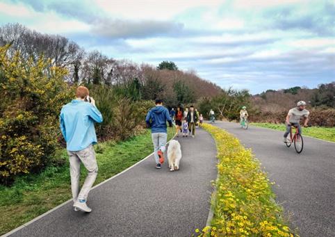
Kings Park, Bournemouth
Phase one - Harewood Avenue: Completed
• Installation of a new, raised toucan crossing on Harewood Avenue near the roundabout links the cycle and walking path and provides dedicated space for pedestrians and cyclists. The existing toucan crossing and speed cushions further south east on Harewood Avenue have been removed.
• Extension of the 20mph zone covering all arms of the roundabout onto Harewood Avenue, Littledown Avenue and Harewood Crescent.
The work is being carried out in three phases.
New Toucan Crossing on Harewood Avenue, Kings Park
Phase two (November 2021 to September 2022) - Ashley Road to Harewood Avenue:
Currently Under Construction
Will include:
• A new, separate cycle path is being installed next to the existing footpath between the Vitality Stadium and Harewood Avenue. This will create a 2m wide footpath and a 3m wide two-way cycle path, separated by an area of wildflower planting where space allows • A new separate 3m wide two-way cycle path and 2m wide footpath separated by an area of wildflower planting is being installed alongside Kings Park Bowling Green • Improved cycle and walking facility alongside the car park by the Vitality Stadium • A new informal raised crossing is being installed over Kings Park Drive between the car park at the Vitality Stadium and Kings Park Bowling Green to slow traffic and provide a safer area for pedestrians and cyclists to cross • Improvements to existing lighting and installation of new lighting through the park to improve safety and security • New wayfinding signage • Disabled parking spaces are being relocated from the eastern side of the cricket pavilion and café to the Ashley Road side of the building. This will allow space for the construction of a new improved access ramp to the cricket pavilion and café • Installation of new larger raised crossing, improved pedestrian facilities and cycle parking facilities outside the café • Changing some parking bay locations on Kings Park Drive to create safe access along the new cycle track. Bollards will be installed on the existing line-marked cycle lane on King’s Park Drive to prevent vehicles from parking within it
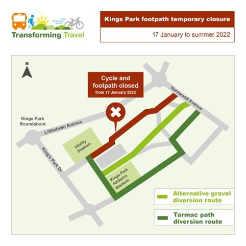
Construction of the new separated cycle and walking paths in Kings Park, between the AFCB Vitality Stadium and Harewood Avenue is now underway. During this time, the existing footpath between the stadium and the car park will be closed with a diversion route in place around the athletics stadium.
Artists Impression of the new Cycle and Walking lanes through Kings Park
Phase three (estimated start/completion dates summer 2022 to winter 2022) -
Harewood Avenue to Sevenoaks Drive
Will include:
• Improvements to the existing shared use cycle and walking path between Kings Park and Cowell Drive, including widening where required, and vegetation clearance • Other existing cycle and walking paths on the eastern side of Kings Park will be widened and resurfaced • Upgrading of existing lighting and installing of new lighting to improve safety and security for users

Chaseside - Iford Roundabout
Riverside Avenue to Jumpers Common
Proposals include:
• New and improved crossing points on Holdenhurst Road • New two-way shared paths on both sides of Holdenhurst Road, between Station Roundabout and the Wellington Road Roundabout • Junction layout revisions to give more priority to people walking and cycling, at the junctions of Holdenhurst Road and various adjoining roads • Improvements along Windham Road and other local roads to provide a quiet route for cycling and walking, including upgraded speed humps, new raised table junctions, improved lighting and new wayfinding signage.
Bournemouth railway station to/from Jumpers Common, Christchurch Holdenhurst Road - Ashley Road Proposals
Potential alternative route option via Windham Road
Improvements at roundabout to make it easier for people walking and cycling to cross Street furniture to be removed and traffic lights upgraded
New two-way shared paths on both sides of Holdenhurst Road Improvements to existing bollards to make cycling safer and easier along Northcote Road
Victoria Place Cleveland Road
Wellington Road Holdenhurst Road Lytton Road
Improvements to bus facilities
Spring Road
Quiet route along Windham Road, with upgraded speed humps and new wayfinding signage
Raised table at junction to encourage slower vehicle speeds and make it safer and easier for pedestrians to cross
Curzon Road
Windham Road South RoadBoscombe Grove Road
Route continues along Boscombe Grove Road, with new raised table at junction to encourage slower vehicle speeds New shared path connecting to bridge over railway
Cyclists able to use Boscombe Grove Road and South Road in both directions to connect to existing crossing on Ashley Road (existing one-way operation retained for all other traffic) Proposals continue into Kings Park
Ashley Road Route connects to existing shared use path outside King’s Park Academy
Key
Shared Path
Carriageway
Footway
N
St Swithun’s Road New toucan crossings across Holdenhurst Road
Towards Station Roundabout
New raised tables to be installed at junctions of Boscombe Grove Road and South Road to encourage slower vehicle speeds
This map is a diagrammatic interpretation of proposals as of February 2021. Not to scale. Existing facilities, including footways and crossings, to be retained unless otherwise indicated. Adjoining roads only indicated as points of reference. Road markings not included.
Toucan Crossing Revised junction layout giving more priority to pedestrians and cyclists
Proposals include:
• Improvements along Chaseside, with new crossing points and a protected two-way cycle track on northern side of road • Riverside Avenue junction improved, providing space for better crossing points • New shared path on north-east side of Castle Lane East, between Riverside Avenue and Iford Roundabout • Junction layout revisions to give more priority to people walking and cycling, at the junctions of Castle Lane East and Holdenhurst Avenue, Cheriton Avenue, Holmfield Avenue, Iford Close and Bridle Crescent • Existing shared path through woodland north of Castle Lane East would be improved by surfacing • New protected space for cycling on south-west side of Castle Lane East, between Riverside Avenue and Bridle Crescent
Proposals include:
• New shared path between existing paths near Riverside Avenue and the bridge crossing point • Existing footpath upgraded to shared path for walking and cycling between the bridge that crosses the river and Stour Way, with new wayfinding signage and surfacing, subject to agreement with golf course operator.


