7 minute read
Improving the Finnish Doppler lidar network’s capability for AEROSOL OBSERVATIONS

from Ilmansuojelu 4/2022
by Ilmansuojelu

Ilmansuojeluyhdistys myöntää vuosittain stipendejä ansioituneiden opinnäytetöiden tekijöille. Tässä lehdessä on kaksi stipendin saajan kirjoittamaa artikkelia.
The capability of Halo Doppler lidars network in Finland has been assessed and demonstrated. It shows excellent potential for applications in not only aerosol science but also air quality and aviation safety.
Advertisement
Viet Le, Researcher, Finnish Meteorological Institute
Atmospheric aerosols are emitted either from anthropogenic activities (industry, transportation, etc.) or natural sources (forest fires, volcanic ash, etc.). They play a crucial role both in climate and in human’s life.
Near the surface, aerosol particles such as dust and pollen have a negative impact on air quality and human health. Meanwhile, elevated aerosol from high altitude such as from volcanic eruptions or desert dust presents an imminent threat to aviation safety. One of the recent major incidents was the eruption of Eyjafjallajökull volcano in Iceland in April and May 2010, which caused major interruptions in the air traffic system over Europe for days. Although these kinds of events are rare, they can have severe impacts on the environment and economy. High resolution data of aerosol vertical and horizontal distribution could play a crucial role to mitigate the impact of hazardous aerosol emissions for the aviation industry. One of the motivations for this study is to improve the security of supply by air traffic in Finland by better volcanic ash detection.
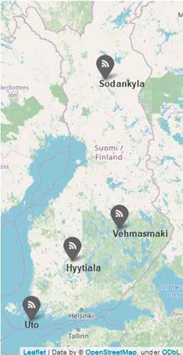
At Finnish Meteorological Institute, a ground-based network of Halo Doppler is used to collect data of atmospheric vertical profiles continuously 24/7 across Finland up to 9 km above ground level (Figure 1).
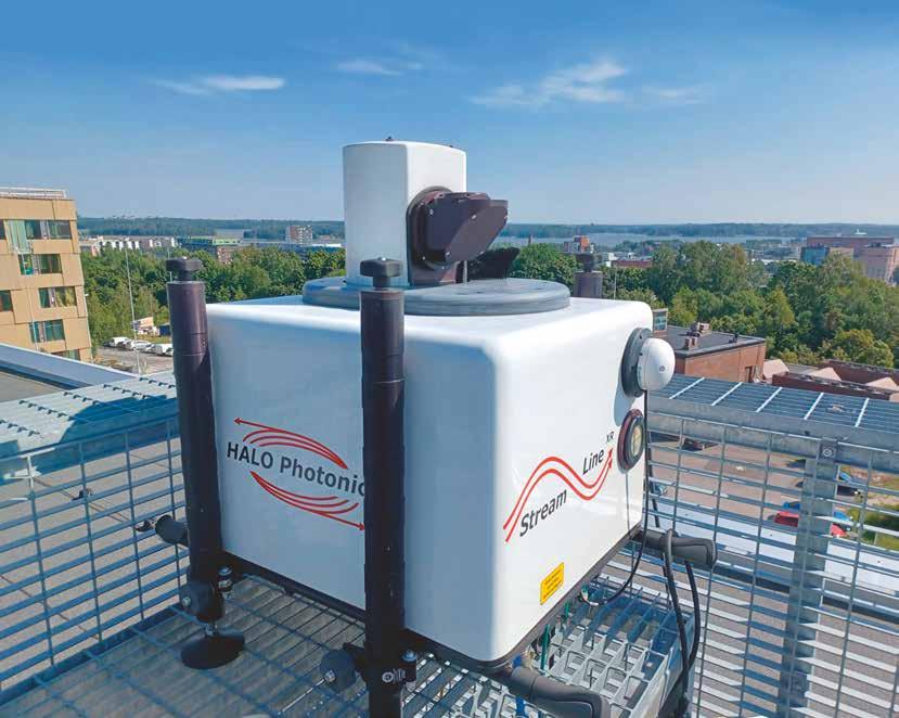
Doppler lidar (Figure 2) is an instrument that is conventionally utilized for wind measurement such as in airports for wind shear detection. It emits laser pulses and measures the light scattered back by particles and hydrometeors in the atmosphere. Based on
Figure 1: Locations of Halo Doppler lidars network that was utilized in this study in Finland
Figure 2: A Halo Doppler lidar on the rooftop of Finnish Meteorological Institute in Helsinki
the wavelength difference between the emitted and received light, the (along-beam) wind speed can be derived. Here, we evaluate the Halo Doppler lidar’s capability to retrieve weak signals of aerosol depolarization ratio in continuous long-term operation.
The focus of this study is the aerosol depolarization ratio, which is a parameter that depends on the sphericity of the aerosol particles. The aerosol depolarization ratio enables classification of aerosol into different categories such as smoke, dust, marine and volcanic ash. For instance, marine aerosol is spherical and has very low depolarization ratio, while dust and ash are non-spherical and have high depolarization ratio.
The structure of this study consists of three main parts. Part one is to assess the quality of the data from the instruments in the network. In part two, a robust aerosol identification algorithm was created to extract the overall statistics of aerosol depolarization ratio. Finally in part three, a study case was shown to demonstrate the capabilities of the lidar network in detecting elevated aerosol layer that was transported into the Finnish airspace.
In the first part, the time series of background signal-to-noise ratio was collected daily and analyzed. The background signal is supposed to follow Gaussian distribution with zero mean and, it can be used to assess any deterioration of the instrument. In addition, depolarization ratio at liquid cloud base is collected throughout the whole study period to determine the bleed-through (Vakkari et al., 2020) of the instruments. By comparing the differences between measured depolarization ratio and the hypothetical depolarization ratio of liquid cloud base (the value should be zero due to spherical droplet shape), the statistics of bleed-through can be obtained. This study found that most instruments in the network are stable and durable. Some deviations of background noise were observed in some instruments, but it was determined to be within an acceptable range. Small bleed-through values were detected in all instruments, and the depolarization ratio values were corrected accordingly.
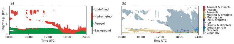
Figure 3: [a] Results from the aerosol identification algorithm and [b] Cloudnet classification algorithm on 2018-04-08 in Hyytiälä
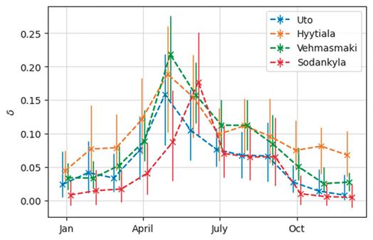
Figure 4: Monthly averages of aerosol depolarization ratio at all locations
After assessing and improving the data quality of all the instruments in the network in the first part, the data analysis can start in the second part. An algorithm was created to distinguish aerosol from clouds and precipitation using only data from the Halo Doppler lidar. The result from the algorithm was compared to the operational Cloudnet’s classification algorithm (Illingworth et al., 2007) which utilizes a combination of data from multiple instruments such as ceilometer and cloud radar. Overall, the aerosol identification algorithm agrees very well with aerosol from Cloudnet’s classification algorithm (Figure 3).
By applying this algorithm to the whole data set, the statistics of aerosol depolarization ratio was obtained. The overall pattern of aerosol depolarization ratio is displayed in Figure 4. The aerosol depolarization ratios peak during summer, when pollen is abundant, and remain at the lowest in the winters. During summer, high depolarization ratio, which is a characteristic of pollen, can be observed during the daytime at most sites. In contrast, in the Utö island, the high depolarization ratio is observed at night, which suggests that pollen is transported to Utö from land at night. In the final part of the analysis, a case of transported dust originated from Sahara Desert was observed by the network as shown in Figure 5. An aloft layer of aerosol was detected from 2018-04-14 21:00 UTC to 2018-04-15 10:00 UTC at Hyytiälä. Through simulation utilizing historical meteorological data, this layer of airmass is found to have been travelling for more than five days from Africa. The depolarization ratio of this layer is at around 0.24 ± 0.008, which is
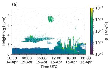
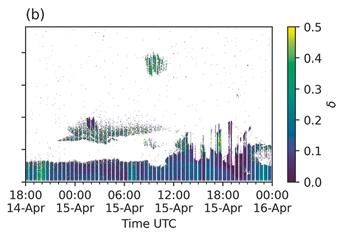
Figure 5: [a] Attenuated backscatter and b) Depolarization ratio profiles from 2018-04-14 18:00 UTC to 201804-16 00:00 UTC in Hyytiälä.
comparable to depolarization ratio of Saharan dust from literatures. The detection of this layer demonstrates the potential of the Doppler lidar network of providing timely warning for aircrafts and for air quality authority.
To sum up, this study offers a long-time view of aerosol depolarization ratio at 1565 nm wavelength, which is not common in literature. This is a steppingstone to the advancement of our understanding in aerosol science. The result also demonstrated excellent capability of the Doppler lidar network in monitoring transported aerosol and identifying its type and origin. This, in turn, would support air quality monitoring and improve the safety of aviation and the security of supply in Finland.
This article is based on Viet Le’s thesis, the thesis and full bibliography are available at: https://helda. helsinki.fi/handle/10138/334773
The bibliography
Hirsikko, A., O’Connor, E. J., Komppula, M., Korhonen, K., Pfüller, A., Giannakaki, E., Wood, C. R., Bauer-Pfundstein, M., Poikonen, A., Karppinen, T., Lonka, H., Kurri, M., Heinonen, J., Moisseev, D., Asmi, E., Aaltonen, V., Nordbo, A., Rodriguez, E., Lihavainen, H., Laaksonen, A., Lehtinen, K. E. J., Laurila, T., Petäjä, T., Kulmala, M., and Viisanen, Y.: Observing wind, aerosol particles, cloud and precipitation: Finland’s new ground-based remote-sensing network, Atmos Meas Tech, 7, 1351–1375, https://doi.org/10.5194/amt-7-1351-2014, 2014.
Illingworth, A. J., Hogan, R. J., O’Connor, E. J., Bouniol, D., Brooks, M. E., Delanoë, J., Donovan, D. P., Eastment, J. D., Gaussiat, N., Goddard, J. W. F., Haeffelin, M., Klein Baltinik, H., Krasnov, O. A., Pelon, J., Piriou, J. M., Protat, A., Russchenberg, H. W. J., Seifert, A., Tompkins, A. M., van Zadelhoff, G. J., Vinit, F., Willen, U., Wilson, D.
Abstract
In order to improve our understanding of the role of aerosol in climate and the capability to detect volcanic ash, a ground-based network of Halo Doppler lidars is used to collect data of aerosol vertical profiles across Finland.
Data quality of the network has been assessed and improved. A robust classification algorithm is created to extract aerosol depolarization ratios from the data to calculate overall statistics. The aerosol depolarization ratios, which describe the spherical shape of aerosol particle, are found to vary by season and location. They peak during summer, when pollen is abundant, but they remain at the lowest in the winter. Several cases of long-range transported aerosol were detected by the network, one case of Saharan dust was shown here.
This study offers an overview of depolarization ratio for aerosol at a wavelength of 1565 nm, which is not commonly reported in literature. This opens a new possibility of using Doppler lidars for aerosol measurements to support air quality monitoring and the safety of aviation.
R., and Wrench, C. L.: Cloudnet: Continuous evaluation of cloud profiles in seven operational models using ground-based observations, Bull Am Meteorol Soc, 88, https://doi.org/10.1175/BAMS-88-6-883, 2007.
Vakkari, V., Baars, H., Bohlmann, S., Bühl, J., Komppula, M., Mamouri, R. E., and O’connor, E. J.: Aerosol particle depolarization ratio at 1565 nm measured with a Halo Doppler lidar, Atmos Chem Phys, 21, https://doi. org/10.5194/acp-21-5807-2021, 2021.


