https://doi.org/10.22214/ijraset.2023.49968

11 IV April 2023
ISSN: 2321-9653; IC Value: 45.98; SJ Impact Factor: 7.538

Volume 11 Issue IV Apr 2023- Available at www.ijraset.com

https://doi.org/10.22214/ijraset.2023.49968
ISSN: 2321-9653; IC Value: 45.98; SJ Impact Factor: 7.538
Volume 11 Issue IV Apr 2023- Available at www.ijraset.com
Vijay Lakshmi1, Nazim Tariq2
1Government College for Women, Parade Ground Jammu, Jammu and Kashmir, India
2Akhtar Public Higher Secondary School, Doda, Jammu and Kashmir, India
Abstract: Jammu city has faced unprecedented growth of population. Before fifties Jammu was small town but after 1971 it starts growing both in size and shape. Due to migration from valley and rapid industrialization (between 1989 to 1994) the population of Jammu grew up to 7, 27,940 representing 225.90% increases over 1981 population. The focus of this paper is on the cause and effects of urban sprawl through landsat images. Remote sensing and GIS techniques have been used to analyze the urban sprawl mapping and detect changes of urban Sprawl of Jammu city through different year. Satellite data have been extracted from different sites which are useful in mapping and quantifying the extent of urban area of Jammu city in different time periods. Urban Sprawl is one of the burning issues in Jammu that may boost up at a vigorous rate after 1972 the land use under the agriculture continually declines at a faster rate which presents the threat to the food security for human life. At present Jammu city has sprawling towards its all direction along the main transport routes. In this study Geographical information system (GIS) and different satellites images have been used to extract the buildup area of different year (from 1972 to 2017) which is useful for urban planning.
Keywords: Urban Sprawl, Remote sensing, GIS, Landsat, Jammu.
Suburbs and the spreading of the city are called Urban sprawl. It spreading mainly in out skirts of the city and in rural or undeveloped areas, in the rural and undeveloped land which are situated in the out skirts of the city involves the construction of commercial building and residential areas. In the urban sprawl most of the people live in the nuclear or single family homes which are do their job in city and there transportation are through by private or own auto mobiles. For local environment and residents, the over consequences of urban sprawl are positive and negative both. In our local economy urban sprawls play a vital role for its growth (1)
Basically urban sprawling is another word of urbanization. At present Jammu city has sprawling towards its all direction along the main transport routes. Due to industrialization and growth of population puts pressure upon the land of the city. Beside this Migration of Kashmiri Pandits also increases the population of Jammu city, which cause congestion and lots of problem in core of the city. Due to which people living in city move towards periphery areas of the city. Another reason is day by day competition to earn quick money, robbery; crime has been done in city which was not in periphery area of the city that’s why people move towards its periphery areas. Due to Sprawling agriculture land has been change into buildup area and the price of land increase as a result slums have been created. For positive and negative effect of our local and social economy urban sprawl is most important thing, which have the great effect in the respect of urban development. Those people who live in new urban areas drive more for their daily requirement as compared to those people who lives in city. Suburbs often provide cheap land for the construction of residential and commercial buildings which is not available in the city.
1) To analyze the urban sprawl of Jammu city.
2) To know the cause of urban sprawl.
3) To understand the effects of urban sprawl
To achieve the objectives, both primary and secondary data is used for this study. The primary data in the form of LANDSAT were extracted from USGS site.

ISSN: 2321-9653; IC Value: 45.98; SJ Impact Factor: 7.538
Volume 11 Issue IV Apr 2023- Available at www.ijraset.com
The secondary data in the form of city map of Jammu which is used to generate the shape file of the city area With regard to this study for data preparation and organization, data analysis and output generation computer hardware and software are used for the study. The ArcGis 10 software is used for preparing and analyzing the data. All the images were first geo-referenced These images were digitized using ArcGis 10 software in the form of polygons.


Jammu is the south western district of UT Jammu and Kashmir. It lies between 32 º 27 and 33º 50 N latitude and to 75º19 and 75º 20 E longitude, with an approximate geographical area of 2,942 sq. km. It is situated on the banks of the Tawi River and in the foothills of Himalayas. It is known for its ancient temples and famous for Hindu shrines. It is also known as Gateway of Kashmir. Jammu is named after its founder, Raja Jambulochan, who is believed to have ruled the area in the 9th century. The local tradition in fact holds the city to be 3000 years old but this is not supported by historians.
Urban sprawl and population trends in the city Urban sprawl refer to the area expansion of urban concentration beyond what they have been. Urban sprawl can be continuous, ribbons or check broad type. The increase population and rapid urbanization causes great change in the center of the city and the problem of the expansion of the city center is complicated by the fact that, it must take place within the built-up area which is not possible. Thus the pressures of the continuous growing city center gradually change the surrounding environment and neighborhoods. Sprawl generally refers to some type of development with impacts such as loss of agricultural land, open space, and ecologically sensitive habitats.
ISSN: 2321-9653; IC Value: 45.98; SJ Impact Factor: 7.538
Volume 11 Issue IV Apr 2023- Available at www.ijraset.com
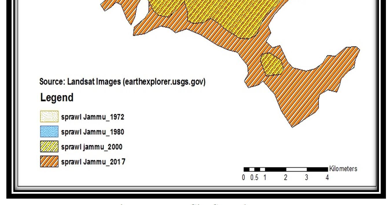
In simpler words, as population increases in an area or a city expands to accommodate the growth; this expansion is considered as sprawl. Usually sprawls take place on the urban fringe, at the edge of an urban area or along the highways (2) The present study is based upon Jammu city which is spread over 86.60 Sq.km of land, which is also the municipal limit of the city. In Northern India it is one of the fast developing cities. The land use of the city over a period from 1972-2017 showed tremendous rises in the built-up from agricultural area, vegetation and vacant land. There were declines in agriculture and vegetation land in and outside the urban area. In this period of time industrial and residential areas of city were dominantly expanded. From 1972 to 2017, settlements increased to 50.59 sq.km (59%), respectively. The rapid increase of population and urbanization cause great change in the centre of the city. Sprawls generally refer to some type of development with impact also such as loss of agriculture land, increase in price of land and open space. In simple words as population increase in an area or a city expands to accommodate the growth, this expansion is considered as sprawls. Fig 2.1 shows the Urban sprawl of Jammu city from 1972-2017 In 1972 the total build up area inside the Jammu city was 14.51sq.km with an increase of 20.38 sq.km in 1980, 62.00s q.km in 2000 which rose up to 65.44 sq.km in 2017. At present city is sprawling towards all direction along the main transport routes.


ISSN: 2321-9653; IC Value: 45.98; SJ Impact Factor: 7.538
Volume 11 Issue IV Apr 2023- Available at www.ijraset.com

Agriculture Land
Build up Area
Forest Wasteland
Water bodies
Agriculture Land
Build up Area
Forest Wasteland
ISSN: 2321-9653; IC Value: 45.98; SJ Impact Factor: 7.538
Volume 11 Issue IV Apr 2023- Available at www.ijraset.com
Agriculture Land
Build up Area
Forest Wasteland
Water bodies
LAND
CITY 2017
Agriculture Land
Build up Area
Forest Wasteland
Table 2.1 and Fig.2.3 reveals that the lands use of the city over a period from 1972-2017 showed tremendous rises in the built-up from agricultural area, vegetation and vacant land. There were declines in agriculture and vegetation land in and outside the urban area. In this period of time industrial and residential areas of city were dominantly expanded.
As it was mentioned, sprawl has some characteristics that differs it from other kinds of urban growth and specialists have different viewpoints about its causes. Bruckner and Fansler studies in 40 United States urbanized areas in the US by surveying indicators such as agricultural land price, commuting expenditure, income, show that sprawl is a consequence that has gained over the time. Rely on Miezkowski & Mills researches; urban sprawl is a consequence of income and population growth, transportation systems improvements, diversity in choice of users and competition for land. These are natural indicators. Some other indicators such as high taxation, crimes, damaged infrastructures, numbers of educational centers have seen in central regions and reinforce urban sprawl.(3) Following are the various causes for the urban sprawl are:
Rapidly increasing population lies in the basis of various factors causing urban sprawl. Apart from the effect of increase in birth rate, migration from rural to urban place also has great impact on rapid population increase in urban area.
ISSN: 2321-9653; IC Value: 45.98; SJ Impact Factor: 7.538
Volume 11 Issue IV Apr 2023- Available at www.ijraset.com
As a result of this uncontrolled growth, problems arising from city becoming crowded direct people to live out of city center which causes urban sprawl. Apart from increasing population, increase in household income is among the factors which cause urban sprawl. (4) The first and foremost reason for urban sprawl is increase in urban population. The two factors that add the population of urban area i.e. a) Natural increase in population, and b) Migration to urban areas.
Table 2: shows the population Growth of Jammu city (1901-2011)
SORCES: Census of India
Table 2.1 reveals that Jammu city is fast growing city of India in terms of population. Before fifties Jammu was small town but after 1971 it starts growing both in size and shape. Jammu city has faced unprecedented growth of population due to influx migration of Kashmir Pandits and growth of commercial and industrial activities. Due to migration from valley and rapid industrialization (between 1989 to 1994) the population of Jammu grew up to 7, 27,940 representing 225.90% increases over 1981 population. Population growth is one of the major factors that contribute towards urban sprawl Besides this after industrialization city become the hub of economic activities. People from different areas come there for Job, education and for other purpose. Due to day by day rapid growth of population puts pressure upon land caused lots of problems in city. Due to which people living in city move towards periphery areas of the city. Another reason was day by day competition to earn quick money, robbery; crime has been done in city which was not in periphery area of the city that’s why people move towards its periphery areas. After the establishment of university people build their houses slowly towards university side. At present city is sprawling towards its all direction along the main transport routes.
It is also one of the major causes of urban sprawl. Due to rapid growth of population cause lots of problem in city like robbery, crime, pollution and many other to avoid these problems people build their houses in periphery areas of the city and the land rate of suburbs of cities are affordable as compared to city centres.
Due to lack of space in city people doesn’t build their house according to their own needs, people of high economic groups need lots of space for house they prefer large house with more bedrooms, bigger balconies and lawns and a playground for their children which is not possible in city. Generally people look out for low density residential areas where they can build their house according to their own needs and requirement that’s why people move towards the all direction of the city
Due to industrialization city become the hub of economic activities which raise the incomes to allow the people to commute longer distance. People build their houses in periphery areas, they come city for Job after work they commute to their house with their own auto mobiles.
ISSN: 2321-9653; IC Value: 45.98; SJ Impact Factor: 7.538
Volume 11 Issue IV Apr 2023- Available at www.ijraset.com
It is also another major cause of urban sprawl. City centre often have much more tax rates as compared to periphery. Due to this reason people build their houses in suburbs.
Beside these indicators there are some other causes of urban sprawling, people build houses in periphery of city due to development of infrastructure, they also build their house to get fresh environment without pollution, congestion which is much higher in city as compared to its periphery. People also move because in periphery areas there are lacks of urban planning and people build their houses according their own needs and requirement. At present Jammu city has sprawling in all direction and with the passage of time it meets with another districts of Jammu.
The way India is growing in terms of its cities various challenges appear in its way. Being a developing country, crucial becomes the decision making of whether to follow or not to. Such challenge needs to be addressed for improved city conditions. (5)
Following are the impacts observed due to the urban sprawl in Jammu are:
1) The fertile agriculture land has been changed into build up area. The land area under Agriculture in 1972 was 44.51 sq. km. which continually undergoes declination as it reaches up to 38.69 sq. km. in 1980 and even in between 1980 and 2000 it reaches to zero. This may cause a great decline in the agricultural activities in Jammu, which presents the threat to the food security for human life.
2) There is continuous increase in the land use for built up purpose.
3) Due to the massive use of land for built up purpose there is encroachment of forest area and it reaches to its lowest level
4) Change in climatic pattern is one of the most facing problems due to changing land use pattern.
5) Due to rapid growth of population puts pressure upon land caused lots of problems in city. Due to heavy traffic in the region, the infrastructure may not be able to cope up the increased rush thus leading to overcrowding poor sanitation which may further lead to diseases. Vehicles are the major cause of air pollution, according to the union of concerned scientist, “poor air quality increased respiration ailments like asthma and bronchitis.
6) All the above-mentioned aspects may lead to depletion of water bodies.
In areas where sprawl is not controlled, the concentration of human presence in residential and industrial settings may lead to an alteration of ecosystems patterns and processes. Development not only decreases the amount of forest area, farmland, woodland and open space but also breaks up what is left into small chunks that disrupt ecosystems and fragment habitats. Roads, power lines, subdivisions and pipelines often cut through natural areas, thereby fragmenting wildlife habitat and altering wildlife movement patterns. The fragmentation of a large forest into smaller patches disrupts ecological processes and reduces the availability of habitat for some species. Some forest fragments are too small to maintain viable breeding populations of certain wildlife species. (5)
From the above discussion, it can be concluded that Urban Sprawl is one of the burning issue in Jammu city that may boost up at a vigorous rate after 1972 the land use under the Agriculture continually decline at a faster rate and same is in the case of land use under the forest waste land, water bodies and the land use for the settlement continuously increases. No doubt this may led to the greater development of Jammu like better health facilities, increase Job opportunities, educational opportunities and better housing facilities etc. but, at the same time it creates a lot of problems like changing climatic pattern, pollution and rise of slums (locally termed as Jughi Jhopri) etc. In this study Geographical information system (GIS) and different satellites images have been used to extract the buildup area of different year (from 1972 to 2017) which is useful for urban planning. Geographical information system (GIS) helps a lot in monitoring urban sprawl as compared to conventional techniques.
[1] Dubey Priyanka and kumar Dilip (2013) “Urban sprawl and its impact on urban environment” Volume 9, pp-26.
[2] Malik Tahir, Rather.A.Manzoor and Amin Arshad (2013) “Urban Land use Dynamics and its future prospectus” volume 9, pp-53.
[3] Habibi. S and Asadi.N (2011) “causes, results and methods of controlling urban Sprawl”pp-136-137.
[4] karakayaci zuhal (2016) “zuhal()the concept of urban sprawl and its causes” volume 9,pp- 817
[5] Tiwari Arpit and G.Vidhi (2017) “Urban sprawl Causes, Effects and Remedies for Indian cities”volume-11, pp64.