
11 minute read
Project Summary


Why the Need?
The Fargo-Moorhead (F-M) metropolitan area is a major health, educational, cultural, and commercial center serving southeastern North Dakota and west-central Minnesota and has been historically prone to significant flooding.
Advertisement
The Red River—which forms the border between North Dakota and Minnesota and flows through the communities of Fargo, ND, and Moorhead, MN—has exceeded flood stage in 60 of the past 122 years, including every year from 1993 through 2011. This prompted studies, analyses, and engineering design to develop a plan to manage the flood risk in the F-M area, known as the Fargo-Moorhead Metropolitan Flood Risk Management project (project).
The development of the project has been a joint effort of the Metro Flood Diversion Authority (MFDA), which was established as the local sponsor to develop and manage the project along with the US Army Corps of Engineers (USACE), the federal sponsor. The Joint Powers Agreement created the MFDA and establishes its role as the primary non-federal sponsor for the project. These two groups were tasked with spearheading a diversion project that will bring permanent flood mitigation solutions to the F-M community.
The project will provide flood protection from six rivers that converge in the F-M metro area— Red River of the North, Wild Rice River, Sheyenne River, Maple River, Rush River, and Lower Rush River.
The 1997 flood, which set a record at the time when it crested at 39.72 feet, caused $3.5 billion in damages to Fargo's neighboring cities to the North in Grand Forks, ND, and East Grand Forks, MN—more than the entire cost of this project. In 2009, Fargo-Moorhead set a new record, with the Red River cresting at 40.82 feet and the barely-hanging-on community spending $8.4 million to fight it.
Once the project is ready for operation in the spring of 2027, 260,000 people—and their homes, businesses, and property—will be protected from catastrophic flooding.
Houston-Moore Group
Houston Engineering, Inc. (HEI) has been providing the F-M metro area with floodplain and flood mitigation services since before the 1997 flood. HEI and Moore Engineering, Inc., along with other subconsultants, have combined to provide the MFDA and the USACE with outstanding technical expertise and local knowledge and leadership for the overall project. Since embarking on the partnership in 2012 to provide design consultant services for the MFDA, Houston-Moore Group (HMG) has consistently delivered on critical elements throughout the project. HEI's services for the overall project have included:
• Hydrologic and hydraulic modeling
• Roadway design
• Hydraulic structure design
• Environmental permitting and monitoring
• Construction administration and survey
• Surveying/platting
• P3 plan design review
• Operations plan flood protection for
260,000+ metro area residents, including their homes, businesses, and properties will be in place by 2027
As part of HMG, HEI led the development of the complex unsteady state HEC-RAS model from which design and hydraulic impacts are calculated. The model is arguably the largest unsteady state HEC-RAS model in the country with more than 900 miles of modeled rivers, more than 5,300 river cross sections, and 1,800 one-dimensional storage areas that represent overland agricultural field flooding.
Goals of the F-M Area Diversion Project
Planning for the project started after the 1997 Red River flood, which was a record at the time. Planning accelerated significantly after the record 2009 flood event, when the F-M metro area barely escaped catastrophic flooding after implementing significant emergency measures that included sandbag and earthen levees. After numerous studies, construction of the project was authorized by the US Congress as part of the Water Resources Reform and Development Act of 2014, Public Law 113.121.
The overall goal of the project is to achieve 100-year FEMA accredited flood protection and to reduce 500-year flood levels to manageable levels with additional emergency measures. The project will reduce a 100-year flood level from a river stage of 42.4 feet to a more manageable river stage of 37 feet. The project will reduce a 500-year flood from greatly exceeding the top of levees, down to a river stage of 40 feet, which can be protected against with additional temporary flood mitigation measures.
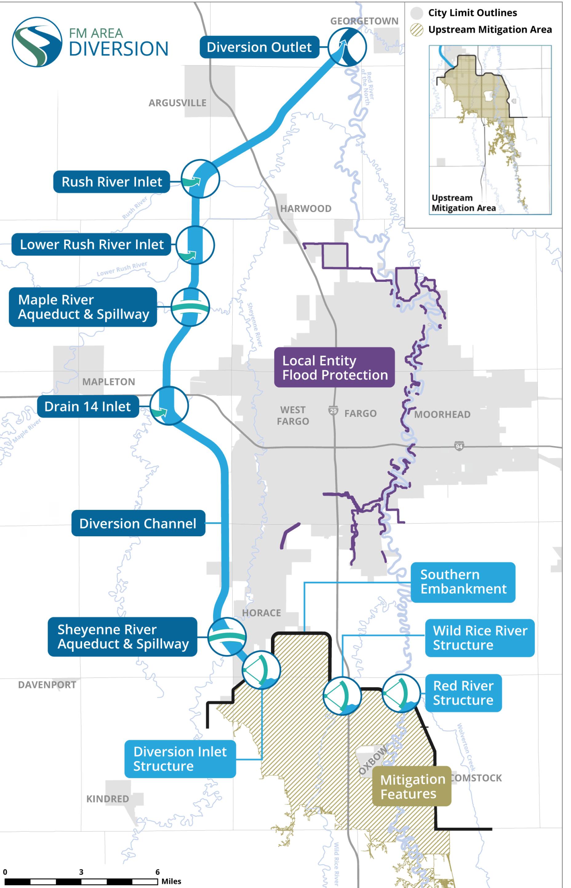
Project Components
The project is a Congressionally authorized federal project that utilizes a split-delivery method. This allows two simultaneous construction schedules to complete the overall project faster and for less expense: The 20-mile earthen embankment is being designed by the USACE and the stormwater diversion channel will be delivered by the MFDA through the Red River Valley Alliance (RRVA). Generally, the overall project is composed of the following four components.
Stormwater Diversion Channel
Southern Embankment
Mitigation Features
In-Town Levees

P3 Partnership
The stormwater diversion channel is being designed, constructed, and will be operated and maintained for 30 years through a public-private-partnership (P3), the first of its kind in North America for a project of this type and the first USACE project to use a P3 model. The RRVA is a consortium of three acclaimed international companies— Acciona, Shikun & Binui USA, and North American Construction Group. The RRVA will build the stormwater diversion channel and its associated infrastructure, including aqueducts, the diversion outlet, and road and railroad crossings. By using a P3 delivery method, the MFDA moves forward with a fixed-price bid while the RRVA assumes the risks of delays and cost escalation. The partnership also allows for using multiple, long-term financing options as well as performance guarantees and long-term warranties. This sets up the project to be completed in less time and with a lower overall cost than with traditional financing methods.
Stormwater Diversion Channel
Channel Design
Prior to the P3 procurement—and as part of HMG—HEI’s activities included basin-wide hydraulic model development used for design and hydraulic impact analysis; stormwater modeling for interior drainage (SWMM); preliminary bridge design; preliminary diversion channel drawings and earthwork calculations; preliminary transportation planning; and permitting. HMG was also involved in initial indicative design alongside the MFDA and the USACE.
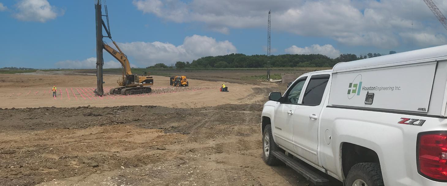
After the initiation of the P3, HMG has been conducting reviews of numerous diversion channel buildable unit design packages and hydraulic models from the RRVA to ensure the proposed design meets the technical requirements and intent of the overall project. HEI used our relationships and work history with Cass County and the North Dakota Department of Transportation (NDDOT) to accurately review the civil design components as well as structures, including bridge designs, concrete aqueducts, and inlet structures.
1 Governing Authority
13-member MFDA Board and staff.
2 P3 Partners
Responsible for designing, constructing, financing, operating, and maintaining the Stormwater Diversion Channel and Associated Infrastructure.
3 Design and Construction Arm of RRVA
Responsible for design and construction of the Stormwater Diversion Channel and Associated Infrastructure.
Southern Embankment
The USACE is leading the design and construction of the 20-mile-long earthen embankment, referred to as the southern embankment. The main purpose of the southern embankment is to regulate water flowing into the F-M metro area and to direct it

Stormwater Diversion Channel into the stormwater diversion channel. When the project is operated, the 20-mile-long southern embankment will be able to temporarily store up to 150,000 acre-feet of flood water at a maximum depth of approximately 10 feet over a 40-square-mile area within the Upstream Mitigation Area (UMA) for a 100-year flood event.
For illustrative purposes only Southern Embankment
This flood storage is designed to offset project impacts as the channel efficiently conveys floodwaters around the metro area. Since the initial feasibility study, HEI’s water resources staff has supported the USACE with hydrologic and hydraulic (H&H) modeling of the project.
Throughout the southern embankment design, HEI’s transportation and structural teams have designed the adjacent roadway corridors, including county and township road raises, the 4-mile-long I-29 road raise, bridges, and numerous box culvert designs as well as drainage, roadway, and structural design for the southern embankment.
To show the magnitude of the project extents for the southern embankment and upstream mitigation area, this graphic shows several lakes near Detroit Lakes, MN, comfortably fitting within the 40-square-mile upstream mitigation area.
The southern embankment will generally have a top width of 15 feet with four foot horizontal to one foot vertical (4H:1V) side slopes. It extends from high ground in North Dakota (between Horace and Kindred) to high ground in Minnesota (southeast of Comstock). The dam will look like a normal township/county road on each end in Minnesota and North Dakota and transition to a full height dam of up to nearly 20 feet above natural ground.
Gated Control Structures
All three gated structures were designed by the USACE. HMG provided design support and hydraulics, civil, and structural quality control review throughout the design process. Aside from HMG, HEI is providing construction survey and staking during the construction of the Diversion Inlet Structure, Wild Rice River Structure, and Red River Structure for Ames Construction.
HEI is providing construction staking for Ames Construction on all three gated structures.
Fargodome
Height = 125 feet
Hjemkomst Center
Height = 100 feet
Red River Structure
Height = 75 feet
Wild Rice River Structure
Height = 75 feet
Diversion Inlet Structure
Height = 75 feet
Project Operation
The project will only be operated during large flood events, that is when the flood flows upstream of the metro area exceed 21,000 cubic feet per second (cfs), which equates to a river stage of 37 feet at the Fargo gage. Statistically, the project would have a 5% chance of operating in any given year. When operation begins, the Tainter gates—which are a type of radial arm floodgates that are used to control water flow—on the Wild Rice River and Red River are lowered into the water to limit the flows into town, generally until flows from the tributary rivers (Sheyenne River, Maple River, Rush River, and Lower Rush River) reach their flood crest. When this happens, the Wild Rice River and Red River flows will be increased to produce the design flood levels through town:
• 100-year = 37 feet and,
• 500-year = 40 feet.
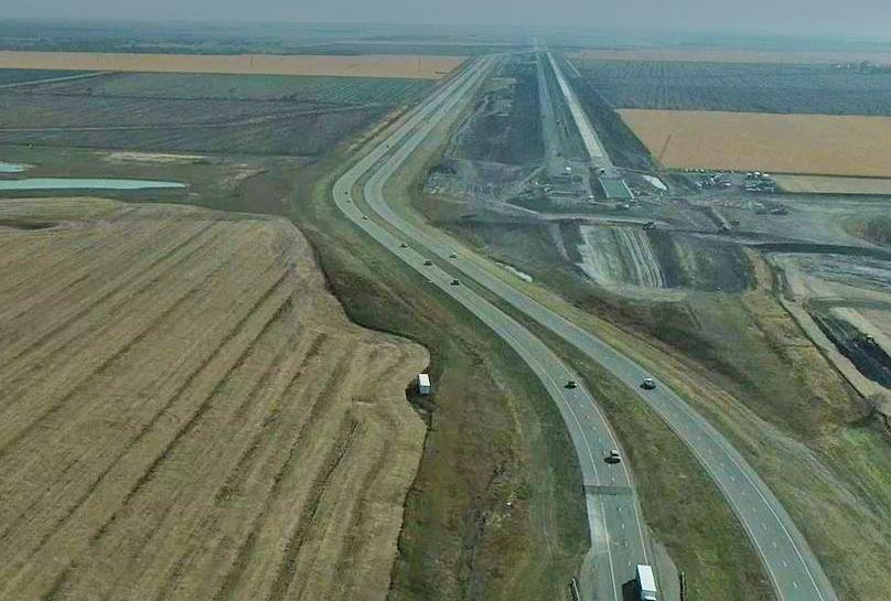
Transportation Components
The UMA within the southern embankment will impact I-29 during project operation. Because of this, 4 miles of I-29 are being raised above the 500-year flood pool elevation
Construction Cost: $115 milion
Construction Cost: $59 million from south of Cass County Road 18 to south of the existing Wild Rice River crossing south of Fargo to continue to maintain interstate mobility through the largest floods.
Construction Cost: $46 million Graphic above courtesy of the MFDA.
The project involves the reconstruction of I-29 to raise the grade of the interstate south of the southern embankment. The roadway will be raised up to 7 feet to maintain access during large flood events. The project also includes the construction of three bridges. Two will be at the I-29 crossing over the Diversion Borrow

Ditch. The third is the Cass County Road 18 overpass structure.
Two 389-foot, three-span prestressed concrete I-beam bridges will provide conveyance within the UMA pool flood waters during large flood events. The Cass County Road 18 overpass will be a 293-foot, three-span prestressed concrete I-beam bridge and will maintain a minimum vertical clearance of 16 feet and 6 inches over the interstate.
Due to settlement concerns and poor Red River Valley soils, HEI worked closely with our geotechnical partners to preload the embankment and preconsolidate the area with the use of a surcharge and wick drain system prior to construction of the roadway and bridges. For the design of the grade raise and the structures, HEI coordinated closely with the USACE, MFDA, and the NDDOT to make certain each agency’s standards and expectations were met.
Construction of the project is anticipated to span three construction seasons. HEI’s involvement during construction has included support for the USACE who is administering the construction of the project as well as being a liaison for the NDDOT and the MFDA.

Mitigation Features
The USACE, along with city and county governments, have been responsible for numerous mitigation projects for the overall project along with the tasks highlighted to the right.
Flowage Easement and Property Acquisition Surveying
The MFDA, via its member entities, is required by federal and state regulatory agencies to obtain property rights from property where floodwater is temporarily stored when the project operates. A flowage easement is an agreement between a landowner and one of the member entities of the MFDA that includes payment to the landowner and gives the MFDA the legal right to temporarily store floodwater on property when the project operates. HEI worked with the MFDA and landowners by preparing property surveys that helped secure more than 70 flowage easements for the mitigation phase of the overall project.
Community Levees
Since the project stores floodwater in the UMA, behind the southern embankment, additional levees are required to protect communities in areas of increased flooding. The USACE designed a levee to protect the Oxbow-Hickson-Bakke area with assistance from HMG. The cities of Christine, Wolverton, and Georgetown are also receiving additional flood mitigation support from the MFDA. HEI, through the Buffalo-Red River Watershed District, is tasked with designing a levee for the City of Wolverton and additional flood mitigation for the City of Georgetown.
2nd Street/Downtown Flood Risk Management Project Fargo, ND
In-Town Levees
In-Town Protection
The cities of Fargo and Moorhead have completed 38.7 miles of a total 40 miles of levees and floodwalls, which are necessary for providing FEMA 100-year accredited flood protection with the project in place.

The in-town levees component of the project includes a series of levees, floodwalls, pump stations, and associated infrastructure through Fargo and Moorhead. These projects were designed to accommodate flows up to a river stage of 37 feet, for 100-year event, during project operation, and all of the recently completed projects were designed to meet FEMA accreditation standards based on the effective base flood elevation.

As part of HMG, HEI and other project partners led the design and provided services during construction for many of these in-town levee project features, including the 2nd Street/Downtown Flood Management Project shown above.
Permitting
The MFDA has implemented a permitting tracking strategy to track permits and monitor compliance for the overall project. HMG is tasked with leading this effort. As part of this, HEI prepared a Permitting Compliance Monitoring and Tracking Plan that summarizes the process and responsibilities for doing so.
As part of the permit tracking plan, HEI is tasked with preparing a monthly Permitting and Compliance Report. The monthly report provides permit information and compliance status on all pending and active work packages (or phases).
To-date, 198 permits (active, pending, and exemptions), with many conditions, are being monitored. Additionally, the status of another 134 City of Fargo and P3 developer permits is also included in the monthly report. These permits include many jurisdictions, such as:
• USACE,
• FEMA Regions V and VIII,
• Natural Resources Conservation Service,
• two states (North Dakota and Minnesota),
• multiple counties,
• watershed districts,
• cities, and
• townships.
More than 2,230 permit conditions are being monitored for compliance. HMG has also been heavily involved with development of permit applications, permit acquisition, and agency coordination.
The Best is Yet to Come
Planning for the F-M Area Diversion project started after the 1997 Red River flood, which was a record at the time. After numerous studies, permits, Congressional actions, and more, the plans are now in place and moving forward. With many pieces of this project fully constructed and others underway, the F-M metro is on track to have permanent, reliable flood protection by 2027.
Stormwater Diversion Channel
Southern Embankment
Project Includes:
30-mile-long
Stormwater Diversion Channel
Mitigation Features
In-Town Levees
150,000 ac-ft flood storage in Upstream Mitigation Area
20-mile-long
Southern Embankment
4-mile-long interstate grade raise
40 miles of in-town levees and floodwalls

FEMA accredited flood protection for
260,000+ metro area residents
Staff Member Snapshot
Greg Thompson has been a driving force in HEI's involvement in the project since the beginning. Greg joined HEI in 2003 and has managed and led numerous water resources projects, including internal urban and rural surface water modeling efforts, to complement designs across the company.
For the past 14 years, Greg has been involved in HEC-RAS hydraulic model development used for design and impact analysis. He has also been instrumental in developing the overall project operations plan.
In collaboration with the USACE, Greg is co-leading the hydraulics support for the southern embankment. He has also been involved in upstream mitigation area modeling and design support as well as review of P3 developer design submittals for the stormwater diversion channel.


