01
University Collage London Year 5 PG21 Tutor: Abigail Ashton, Andrew Porter, Tom Holberton
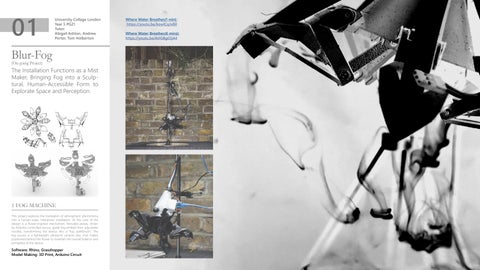
Blur-Fog (On-going Project)
The Installation Functions as a Mist Maker, Bringing Fog into a Sculptural, Human-Accessible Form to Explorate Space and Perception.
1 FOG MACHINE This project explores the translation of atmospheric phenomena into a human-scale, interactive installation. At the core of the design is a flower-inspired mechanism. Movable petals, driven by Arduino-controlled servos, guide fog emitted from adjustable nozzles, transforming the device into a “fog paintbrush.” The fog source is a lightweight ultrasonic ceramic-disc mist maker, positioned behind the flower to maintain the overall balance and portability of the device.
Software: Rhino, Grasshopper Model Making: 3D Print, Arduino Circuit
Where Water Breathes(1 min): https://youtu.be/kowICqJxBiI Where Water Breathes(6 mins): https://youtu.be/ArIGBg03j44
Blur-gerbegehren
# Load the depth image image_path = “/Users/hongyun/241103_streetview_pointcloud/Street View 360.depthmap.jpg” depth_image = cv2.imread(image_path, cv2.IMREAD_GRAYSCALE) input_image_path = “/Users/hongyun/241103_streetview_pointcloud/Street View 360 1.jpg” # Replace with the path to your input image input_image = cv2.imread(input_image_path) if input_image.shape[:2] != depth_image.shape[:2]: input_image = cv2.resize(input_image, (depth_image.shape[1], depth_image.shape[0])) # Define thresholds for “gray” pixels # Adjust these values as necessary to capture only the desired gray range lower_gray = 10 # Slightly above black upper_gray = 245 # Slightly below white where blur can be detected # Create a mask for gray pixels mask = cv2.inRange(depth_image, lower_gray, upper_gray) # Convert gray areas to white and everything else to black #mask_convert_image = np.where(mask == 255, 255, 0).astype(np.uint8) # Apply the mask to the input image masked_image = cv2.bitwise_and(input_image, input_image, mask=mask)
An Architectural Exploration of Pointcloud Blur Through Google Map Streetview.
# Save or display the result cv2.imwrite(“/Users/hongyun/241103_streetview_pointcloud/mask_image_2.png”, masked_image) cv2.imshow(“Mask Input Image”, masked_image) cv2.waitKey(0) cv2.destroyAllWindows()
Coding Parameter Threshold
50
Upper gray
200
Lower gray
50
Divided Rows
15
Divided Cols
30
laplacian_var : 1731.9687480852822
laplacian_var : 4433.071744714491
laplacian_var : 2384.4498726409743
1 POINTCLOUD CODING The lack of comprehensive Street View coverage raises questions about the policies that shaped it and its architectural implications. I aim to further investigate the underlying story and explore how this limitation influences the perception and documentation of urban spaces in Germany. I employed panorama unfolds to deliberately introduce blur. It explores the dynamics of blurring, testing various image resources under different parameters to refine the methodology and enhance the results.
Software: Stable Diffusion LoRA AI Training, Python Scrpting, Blender Pointcloud Render
bigger sizes with more juxtaposition
Detecting German Resident’s Blurring Street
smaller sizes with less juxtaposition
Inpaint Parameter Masked content
original
Mask mode
Inpaint masked
Mask blur
20
Soft inpainting
True
Sampling method
DPM++ 2M
Batch count
3
Model : Stable Diffusion 1.5 Denoising strength : 0.75 The Training Model Outcome to Un-blur Cityscape, with Different German Facade Input
Scale Testing of the size of the Panoramas
Using Depth Map Mask and Edge Detection
A close-up, top-down view of a section of the point cloud with materials applied, showing the intersection between Stallschreiberstrasse and Alte Jakobstrasse.
LoRA Training Process and Parameters
Python Code for Blur Detection
02
University Collage London Year 4 PG21 Tutor: Abigail Ashton, Andrew Porter, Tom Holberton
#convert a depth img into a mask img import cv2 import numpy as np
ELLA YUN HONG
2 BLURRING POINTCLOUD The concept of blur is employed as both a visual and spatial strategy to seamlessly integrate architecture into the surrounding urban fabric. Rather than creating sharp separations between building and landscape, the design embraces transitional conditions—semitransparent materials, fragmented geometries, and layered spatial sequences—to dissolve boundaries.
Pointcloud Landscape Experience: https://youtu.be/mxWBFiplB6I
PORTFOLIO 2024-2025
Software: Unreal Engine Game Experience and Render, Permier Pro Video Edit ELLA YUN HONG
PORTFOLIO 2024-2025
[5]
Trees(High-Water Planting) & Sun Gardens/ Xeriscape(Low-Water Planting)
Moss, Fern, Or Shade-Tolerant Planting
ELLA YUN HONG
3 GENERAL ARRANGEMENT
Water Retention Landscapes(Rain Gardens, Filtered Wetlands) +8,70 +8,50
The concept of blur is employed as both a visual and spatial strategy to seamlessly integrate architecture into the surrounding urban fabric. Rather than creating sharp separations between building and landscape, the design embraces transitional conditions—semi-transparent materials, fragmented geometries, and layered spatial sequences—to dissolve boundaries.
20
55
R 4745
00
20
R 5403
+5.80 +5.20
00
00
00
55
10
0
50
+0.00 10m
5 00
50
0
R 5184 R 5019
R 5925
00
16
00
4000
00
00
00 30 11000
30
20
00
28
4000
65
R 4744
65
00
30
00
60
00 30
5500
70
4500
0
2000
30
0
45
R 6202
00
00
50
R 3925
2000
25
00
14
3500
8
3500
6
8500
4 1:150
8000
2
0 00
13
7 .0
°
5500
0 20 8000
00
00
°
.0 °
3500
3 .5 °
R 6000
00
11
50
0
00
20
25
00
7500
00
00 0 40950
30
3
30
20
7
R 12521
50
0
7 .0
4500
17500
7.
0
0°
00
5000 1
14500
R 9521
0 20
+6000 R 3 6 0 0R 4 1 0 0 R 1950 R 1800
+6000
4500
65
R 3000
R 1200 65
4498 31
+8500
00
58
R 12521 R 5663
R 2769
+6000 R 9521
PORTFOLIO 2024-2025
4502
R 9921
00
+8500 2
Grass Land
4
6
8
10m R 6099
1 :2 0 0
R 4100
Moss Land +8500
Xeriscape
R 8350 R 11000
Rain Garden Soil Ground
Software: Rhino, CAD, Illustrator
Gravel Paving ELLA YUN HONG
PORTFOLIO 2024-2025
[6]
03
Architectual Association Year 3 Unit 3 Tutor: Ricardo Olavo Ostos, Nicholas Zembashi
Programmes & Plantations
In-Between Cocoa Under a Mythical Narrative, Investigating Human & Animal Relationship in Indonesian Cocoa Plantation. Site Observations in Java, Indonesia
1 THE RABBITS’ KINGDOM In Indonesia, a developing country, enhancing animal well-being is a significant challenge. Discussions with sociologist Harry from the University of Indonesia highlighted the influential role of anthropomorphism. The Easter bunnies’ story is transformed into a selling point, with rabbits partnering with cocoa farmers, and cocoa woodlands becoming the location of underground chocolate factories.
Software: Blender Render Assisting, Procreate Drawing, Photoshop Drawing, Illustrator Vector Drawing
Speculating on a new relationship of Rabbits and humans ‘farming’ on a Cocoa Plantation
The Grand Canopy’s Bamboo Components Technical Section 1:67@A2
Design Decisions Design DiagramsDecisions of Iterations Diagrams of Iterations
My proposal involves designing a chocolate factory on a cocoa plantation in Java, Indonesia. The factory will serve as both a production facility and a public space for social interaction, acting as a mediator between the company and smallholder conflicts. Additionally, it will serve as a playground for local children and families.
1 The Pinnacle
Corresponding Construction Detail
ELLA YUN HONG
2 BUMILOKA PLANTATION SITE ANALYSIS
1
Scenographically Hidden Among Trees Scenographically Hidden Among Trees
More Shadow Direct Sunlight
More Shadow
2
Direct Sunlight Too Exposed Need to Cut More Trees
Too Exposed Need to Cut More Trees
Site of Former Kakan Company - Citing Design
Project Citing - Former Corporation Site-Offset from main road , lessen impact on existing trees
Human Access Hidden Architecture
Dry Season Sunpath Shading
2 Upper Nests
3
3 Lower Nests
4
View 1 View 2 More accessible for animals (incests)
Embraces the Topography
More accessible for animals (incests)
Embraces the Topography
Animal Access Underground Routes
4 Sky Atrium
Utilising the Topography Cascading Programmes
PT. BANTEN PRIMA MINERAL, Mining
MtsS Manbaul Ulum, Primary School
5
Rainy Season Peaked Canopy
Local Houses
Surya Mekar, Mixed Farm 5 Factory Atrium
PORTFOLIO 2024-2025
Software: Photoshop, Illustrator, Hand-Drawing Model Making: Laser Cut, CNC
0 ELLA YUN HONG
1m PORTFOLIO 2024-2025
[8]
ELLA YUN HONG
3 ONCE UPON A TIME... Dry Season
Inside the Chocolate Machine
Harvest
Peering into the Cocoa Atrium
Rainy Season
Under the Grand Canopy Chocolate Stalactites The cogs of the chocolate machine turn and turn inside the grand cocoa atrium, with their excess product melting and setting into the canopy
Local Farms Flourish The locals are encourage to maintain their own farmland in the grounds of the new AgroCocoa-Forest
PORTFOLIO 2024-2025
Forcipomyia Midges Sanctuary Crucial pollinators and friendly insects to cocoa are encouraged to inhabit the site
Intercropped Resilience Luscious vegetation of the agroforestry strategy combats monoculture and encourages biodiversity
Peripheral Rattan Shelters Rattan as a new medium for animal feed
Software: Rhino Model, Cinema 4D Render, Photoshop, Illustrator ELLA YUN HONG
PORTFOLIO 2024-2025
[9]
04
Architectual Association Year 2 Intermediate 17 Tutor: Mark E Breeze Katie (Kyriaki) Kasabalis
3D Spaces to 2D Surfaces
Screenshots From Video ‘Home’, Exploring the Relationship Between Screens & Domesticity
Alongly An Augmented Reality Application Envisioning the Future of Collective Domesticity.
Accommodation
Screenshots From Video ‘Home’ in Timeline
Home: https://youtu. be/2GfqWdmTeas
Physical Model Aligning Screenshots from Video ‘Home’ in Timeline
Grid Division
Camera Tracking & Meshing
Visualizing the Switch in Domesticity
1 THE ’SWITCH’ OF DOMESTICITY
Physical Interpretation
With the rapidly growing technology and the acceleration of the pandemic, the Internet becomes a solution for individuals to connect to friends and the world. Single living homes have become the combination of shelters and screens, the switch between reality and virtuality.
Software: Photoshop layout, Premier Pro and After Effect Video Edit Model Making: Laser Cut
Surfaces Re-scanning
24 Hours Study of My Day on 5th May, 2022
ELLA YUN HONG
2 2D MODELS TO 3D SURFACES By constantly activating and deactivating surfaces, can a simulation system transform lonely space into a sociable space?
PORTFOLIO 2024-2025
Using Unity, I developed an App that stored my 3D Scanning Room data and Generated a conversion to the cardboard VR Headset
Software: Unity VR programme, Cinema 4D Camera Tracking, Unreal Engine Render Model Making: Laser Cut
Physical Interpretation Point Cloud Model Close-Ups
ELLA YUN HONG
Screenshots in ‘Home’ and Re-meshing the Scanned Space with Camera Tracing My initial explorations in lonely living and technology
PORTFOLIO 2024-2025
[11]
Future of Domesticity
Introducing Alonely: https://youtu.be/kowICqJxBiI
Diagram Showing Spacially Functions of My ‘Alongly’ Room
01:38-1:50
Setting Personalized Experience
Alongly is an enhanced reality application that imagines individual collective living to tackle loneliness in the digital world. Alonely not only have static interaction but also dynamic space movement, where footsteps become the tool to measure and recreate the existing space into new configurations. Fixed space has been given elasticity that can create new surfaces and boundaries.
Transformation Of Amorphous Domestic Surfaces In Response To Human Movement
My Architecture: https://youtu.be/OqDVjjIW8mg My Site: https://youtu.be/ANuD5f3Gp_k
Renders in ‘Introducing Alonely’ Re-imagining Future Individual-Collective Living 3 modes of ‘Expansion’ applying to my studying space
ELLA YUN HONG
3 AR APPLICATION: ALONGLY
1:51-2:20
2:21-2:42
Space Rotation Back to Socialize
Expanding Small Spaces
Space Rotation to Socialize
Moving in Virtual Spaces
Space Expansion for Studying Space Expansion for Better Visual Experience
Personalized Your Space
PORTFOLIO 2024-2025
Generating New Spaces
2:43-2:55
2:56-3:05
3:06-3:17
Software: Blender Animation, Premier Pro and After Effect Video Edit ELLA YUN HONG
PORTFOLIO 2024-2025
[12]