
21 minute read
TRAVEL, ExpLORATION AND CARTOgRApHy 1-47


Lots 1 – 47
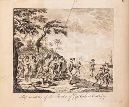
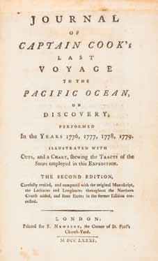
1 COOK, JAMES, CAPT. Journal of Captain Cook’s Last Voyage to the Pacific Ocean, on Discovery, Performed in the Years 1776, 1777, 1778, 1779. London: Printed for E. Newbery, 1781.
8vo, rebound in full brown calf, gilt-lettered spine. Second edition after the first John Rickman edition. Complete with folding engraved frontispiece of the murder of Cook, four plates (one folding, one facsimile), plus folding map. Scattered light brownspotting; 2-inch tear to map; otherwise fine. $1,000-2,000
2 DRUMMOND, ALEXANDER Travels Through Different Cities of Germany, Italy, Greece, and Several Parts of Asia, as Far as the Banks of the Euphrates... London: W. Strahan for the Author, 1754.
Folio, full calf, rebacked, gilt-lettered leather spine label. First edition. Complete with fold-out engraved frontispiece, 30 engraved plates (12 fold-out), and four engraved maps (three fold-out). Calf cracked and slightly chipping; inner hinges starting; scattered light brownspotting; 3-inch tear to “Map of Cyprus.” $800-1,200

1


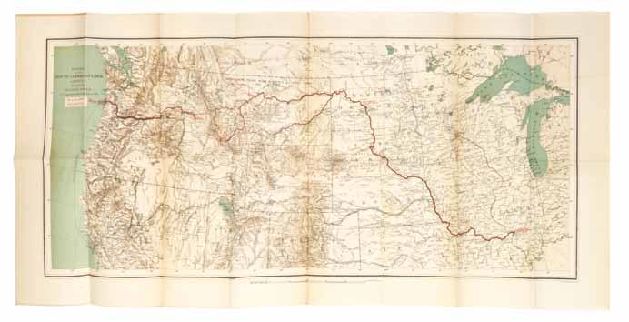
3 LEWIS, MERIWETHER AND WILLIAM CLARK History of the Expedition under the Command of Captains Lewis and Clark, to the Sources of the Missouri, thence across the Rocky Mountains and Down the River Columbia to the Pacific Ocean. Performed during the years 1804-5-6. Philadelphia: Bradford and Inskeep, 1814.
2 vols. 8vo, rebound in modern 3/4 brown calf over marbled boards, gilt-lettered spine. First edition. Complete with five plates and original large fold-out map of Lewis and Clark’s route across the country at the rear of volume one.
This first edition of Lewis & Clark’s narrative is “the definitive account of the most important exploration of the North American Continent” (Wagner-Camp). The expedition was funded by Congress after the Louisiana Purchase for the purpose of establishing trade ties with the Native Americans of the Western region of the United States. The publication of this narrative was delayed due to both Lewis and Clark receiving commissions in the Louisiana Territory as Governor and Superintendent of Indian Affairs, respectively, and due to Lewis’s unexpected death in 1809. In tribute, Thomas Jefferson wrote a Life of Captain Lewis which appears at the beginning of volume one. Nicholas Biddle was employed to edit the work, which was ultimately completed by Paul Allen in 1814.
3
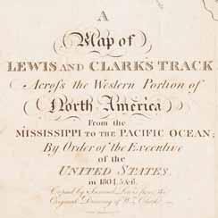
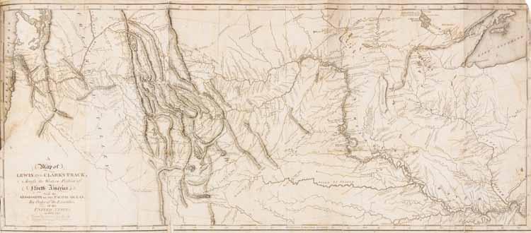
According to Church, of the 2000 copies printed at least 583 were lost or destroyed and not all copies were issued with the large folding map. Originally drawn by Clark, the map is widely considered the best depiction of the West in its day.
Light edgewear; renewed endpapers; ex-library copy with Boston College stamp to verso of fold-out map, rear of vol. 1; intermittent foxing and brownspotting; darkening to some leaves; few examples of pencil marginalia; offsetting from plates; contemporary pen ex-libris “H.H. Hayden” to title page, vol. 1; three 1-inch repaired splits to bottom of fold-out map at folds; 2-inch repaired tear to map at gutter.
Literature: Church 1309; Field 928; Graff 2477; Grolier/American 30; PMM 272; Streeter Sale 3:1777; Wagner-Camp 13:1; Howes L317; Sabin 40828.
$50,000-70,000
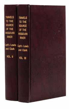
4 4 (LEWIS AND CLARK) Travels to the Source of the Missouri River, and Across the American Continent to the Pacific Ocean. Performed by Order of the Government of the United States, in the Years 1804, 1805, and 1806. London: Longman, Hurst, Rees, Orme, and Brown, 1817.
Vols. II and III (of 3) only. 8vo, rebound in modern calf, gilt-lettered spines. New edition. With three (of five) plates, lacking large folding map in vol. 1. Scattered brownspotting; light offsetting from plates. $1,000-2,000
5 (LEWIS AND CLARK) COUES, ELLIOT, ed. History of the Expedition under the Command of Lewis and Clark to the Sources of the Missouri River, thence across the Rocky Mountains and down the Columbia River to the Pacific Ocean performed during the Years 1804-5-6, by Order of the Government of the United States. New York: Francis P. Harper, 1893.
4 vols. 8vo, original quarter white cloth, printed paper spine labels, title page in red and black. New edition, limited to 1,000 copies, this being number 187 of 200 copies printed on handmade paper. With two portrait frontispieces, eight maps (three large fold-out laid into rear of vol. 4), and two tables. Soiling to boards; ends bumped; spine labels chipped; backstrip beginning to detach from text block, vol. 3; frontispiece detached from vol. 2; lacking two facsimile letters. $500-700
5
6 FREEMONT, JOHN C. Report of the Exploring Expedition to the Rocky Mountains in the Year 1842, and to Oregon and North California in the Years 1843-’44. Washington: Gales and Seaton, 1845.
8vo, original blue cloth, gilt-lettered spine. First edition, Senate issue. With 22 plates and three (of five) maps (two fold-out). Light soiling to boards; dampstaining and browspotting throughout. $400-600
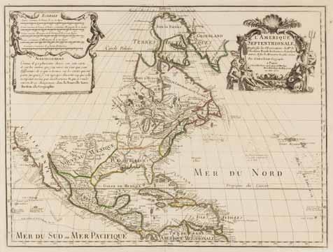
7 DELAVILLE, J.I. Etat Present de la Pensilvanie, ou l’on trouve le detail de ce qui s’y est passe de puis la defaite du General Braddock jusqu’a la prise d’Osego avec une carte particuliere de cette Colonie. [Paris: s.n.], 1756.
8vo, original marbled wrappers. Housed in custom cloth clamshell box. First edition of this primary source on colonial Pennsylvania. With engraved fold-out map and woodcut head- and tail-pieces throughout. Light soiling to wrappers; few scattered brown spots. $500-700

8 (EXPLORATION) Two facsimile editions of exploration works published in the sixteenth and seventeen centuries, including The Discoverie of the Large, Rich, and Beauutiful Empyre of Guiana... by Sir Walter Raleigh, [with] The World Encompassed. By Sir Francis Drake. Cleveland, Ohio: World Publishing, n.d. 2 vols. 8vo, gilt-stamped vellum, housed in cloth clamshell folding cases. $200-400
6
7
9
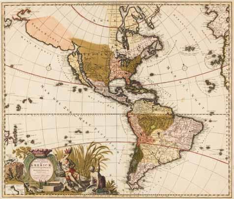
10 9* (MAP) ALLARD, CAROLI Novis Orbis Sive Americae Septentrionalis e Merdionales. [Amsterdam, c. 1700] Double-page engraved map with hand-coloring illustrating North and South America, the Pacific and Atlantic oceans, parts of France and Spain, and the west coast of Africa. With large decorative cartouche flanked by figures to lower left corner. This map depicts some unusual geographic characteristics including oddly shaped great lakes, an overly wide South America, California as an island, and the mythical location Terra Esonis. Framed and matted. 21 x 24 1/2 inches. Property from the Estate of John C. Stevens, Muscatine, Iowa $800-1,200
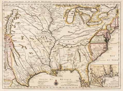
10* (MAP) COVENS AND MORTIER Carte de la Louisiane et du Cours du Mississippi... [Paris, c. 1730] Double-page engraved map with hand-coloring of “one of the most important mother maps of the North American continent” (Cummins), after the first edition of Guillaume De l’Isle’s landmark map which was the first to depict the Mississippi River Valley and to name Texas with the location “Mission de los Teijas,” indicating a Mission established in 1716. The second edition of De l’Isle’s map was the first to name New Orleans, which is not depicted on this edition. Framed and matted. 22 1/4 x 25 3/4 inches. Property from the Estate of John C. Stevens, Muscatine, Iowa
Literature: Cummins 208: Wheat 99; Martin & Martin Pl. 19; Flags along the Coast Pl. 17. $1,500-2,500
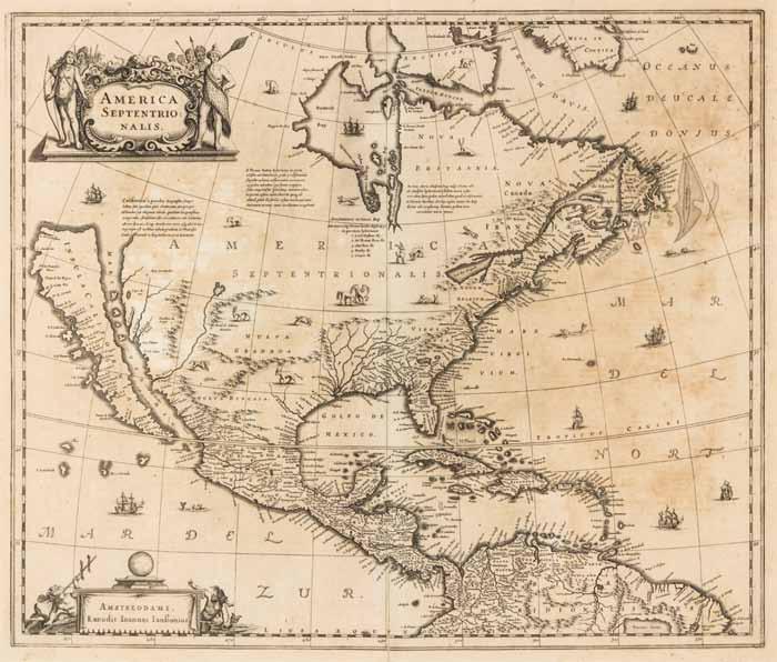
11* (MAP) DELISLE, GUILLAUME L’Amerique Septentrionale. Paris, 1700 [1708]. Double-page engraved map, hand-colored in outline. Though dated 1700, this is the 1708 reissue of De l’Isle’s 1700 map of North America with “sur le Quai de L’Horloge” in the cartouche and Renard’s imprint erased in the plate. This map is the first to show the Sargossa Sea; it is “a foundation map...[with] the Great Lakes based on Coronelli showing the French strong points at Tadousac, Quebec, Fort Sorel, Montreal & Fort Frontenac.... In this map De l’Isle corrected longitude positions and was the first to revert to a peninsula form for California. He stops his western coast at Cape Mendocin” (Tooley). Framed and matted. 21 1/2 x 29 5/8 inches. Property from the Estate of John C. Stevens, Muscatine, Iowa
Literature: Tooley p.19, #30; Wagner NW Coast 459. $500-700
12* (MAP) JAILLOT, HUBERT Amerique Septentrionale divisee en ses principales parties. Amsterdam, n.d. [c. 1690-1692] Double-page engraved map with hand-coloring, after Nicolas Sanson’s map of North America. With two large decorative cartouches flanked by figures of Native Americans. This map depicts California as an island, the Great Lakes with an open source to the west, and a land mass west of California labelled “Iesso.” Framed and matted. 25 x 36 1/8 inches. Property from the Estate of John C. Stevens, Muscatine, Iowa $1,000-2,000

13
13* (MAP) JANSSON, JAN America Septentrionalis. Amsterdam, n.d. [1641] Doublepage engraved map of North America. This map is the first atlas map to show North America only, and the single most influential map in perpetuating the myth of California as an Island (Burden). With decorative cartouche flanked by Native American figures to upper left corner, numerous ships and sea creatures, and native animal wildlife illustrated. Framed and matted. 20 1/2 x 24 3/8 inches. Property from the Estate of John C. Stevens, Muscatine, Iowa
Literature: Burden 245, McLaughlin 6, Wheat 45, Goss, 30, Tooley 28. $2,000-4,000
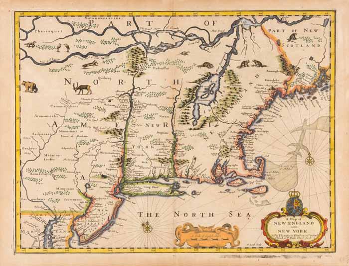
14* (MAP) SPEED, JOHN A Map of New England and New York. [London, 1676]. Double-page engraved map with hand-coloring from Speed’s A Prospect of the Most Famous Parts of the World, (c. 1676). This map of the British colonies in North America is the first to show the name Boston, the first to use the term New York for both the city of Manhattan and the colony, and it is one of the first maps to show New Jersey. English text to verso. Framed in double-sided glass frame. Lightly toned; few brown spots. 16 3/4 x 22 1/4 inches visible. Property from the Estate of John C. Stevens, Muscatine, Iowa
Literature: Burden #455; McCorkle (New England) 676.6; Tooley (America) pp.290-91. $2,000-4,000
14

15 (MAP) THE AMERICAN MILITARY POCKET ATLAS The American Military Pocket Atlas; Being an approved Collection of Correct Maps, both General and Particular, of The British Colonies; Especially those which now are, or probably may be The Theatre of War... London: R. Sayer and J. Bennet, [1776].
8vo, 3/4 dark brown calf over marbled boards. First edition of the “holster atlas,” designed “to suit the pockets of officers of all ranks” for use on the field during the American Revolution. The maps are those “that the British high command regarded as providing essential topographical information in the most convenient form” (Schwartz & Ehrenberg). Complete with six large engraved fold-out maps, hand-colored in outline. Rubbing to boards; contemporary pen ex-libris, Samuel Cowley, to f.f.e.p.; light brownspotting and toning to maps; most maps reinforced at creases with archival tape; minor marginal chipping to maps; light offsetting. Property from the Estate of Jack M. Vorhies, Indianapolis, Indiana
Literature: Howes A208; Phillips, Atlases 1206; Sabin 1147; Schwartz & Ehrenberg, p.19. $4,000-6,000

15
17
16 (MAP) VAUGONDY, ROBERT DE Partie De L’Amerique Septentrionale, qui comprend le cours de l’Ohio, la Nlle. York, le New Jersey, la Pensylvanie, le Maryland, la Virginie, la Caroline. S.l., c. 1788. Double-page engraved map, hand-colored in outline, with decorative cartouche and inset map of Carolina. Framed and matted. 21 3/4 x 29 1/2 inches.
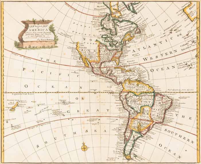
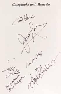
Provenance: Cheryl M. Newby Inc. Fine Prints, Maps, and Engravings, Myrtle Beach, South Carolina. $200-400 17* (MAP) BOWEN, EMMANUEL A New General Map of America. Drawn from several Accurate particular Maps and Charts, and Regulated by Astronomical Observations. S.l., n.d. [1747] Engraved map, hand-colored in outline, depicting colonial North and South America, as well as both the Atlantic and Pacific oceans. Framed and matted. Overall light brownspotting. 15 1/4 x 19 inches. Property from the Estate of John C. Stevens, Muscatine, Iowa $400-600 18* (MAP) COLTON, J.H. The United States of America. New York, 1854. Folding engraved map with hand-coloring. Light brownspotting; separation at creases; two 3-inch tears at folds. 23 1/4 x 29 inches. Property from the Estate of John C. Stevens, Muscatine, Iowa $100-200

19
19* (MAP) HUTCHINS, THOMAS AND GEORGE LOUIS LE ROUGE Partie Occidentale de la Virginie, Pensylvanie, Maryland et Caroline. Paris, 1781. Proof state double-page engraved map with later hand-coloring depicting the American Midwest between the Great Lakes and the Ohio River, west to the Mississippi River. The present copy of this map is a reissue of the original by Thomas Hutchins, published in London in 1778.
This map was the largest and most accurate map of the Midwest at the time of its publication. It illustrates early eighteenthcentury efforts to settle the Midwestern United States, Native American concessions, transportation routes, and the location of major land speculation schemes of the period. The proof issue depicts topographical detail not present in later states, including points north of the meeting of the Mississippi and Wabash Rivers, on both sides of the Shawanee, Cherokee, and Upper Ohio Rivers, and on the south side of the Illinois River.
Framed and matted. 20 x 23 1/2 inches visible. Property from the Estate of John C. Stevens, Muscatine, Iowa
Literature: Brown, Ohio Valley, pl.51; Cumming, British Maps of Colonial America, p.36; Karpinski pp.167-168, no.LXXXXI; Phillips p.983, Pritchard & Taliaferro, no.49; Sellers & Van Ee, no.789. $8,000-12,000
20* (MAP) MITCHELL, AUGUSTUS Iowa. Philadelphia, n.d. [c. 1865] Color lithograph map of Iowa. Framed and matted. 17 1/4 x 14 1/4 inches. Property from the Estate of John C. Stevens, Muscatine, Iowa $200-400
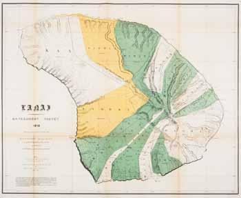
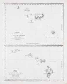
21 (MAP) BURROUGHS, H.N. United States. Philadelphia, 1846. Copper-engraved color map of the Eastern half of the United States. 17 1/4 x 13 3/4 inches. $200-400 22 (MAP, HAWAII) Lanai. Government Survey, 1878. S.l., 1900. Large color lithographed map of the island of Kauai. A re-issue of the 1879 map delineated by Walter E. Wall and Fred Harvey. The island was purchased by James Dole in 1922 for $1.1 million dollars and pineapple was planted there until the 1980s. Folds; some browning to creases. 28 x 34 1/2 inches. $100-200 23 (MAP, HAWAII) Two engraved maps featuring the Hawaiian islands, including Chart of the Parts of the Sandwich Islands... By La Perouse. London, 1798 [and] Map of the Hawaiian Group of Sandwich Islands by the U.S. Ex. Ex. By Charles Wilkes. New York, c. 1845. Size of largest 21 1/2 x 17 1/4 inches. $200-400
22

23
24
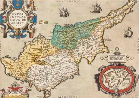
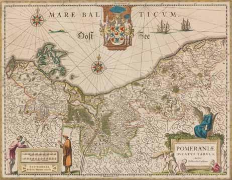
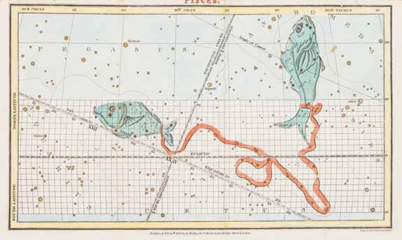
24 (MAP, MEDITERRANEAN) Two maps including Cypri Insulae Nova Descript, [Antwerp], 1573 (from Theatrum orbis terrarum) by Abraham Ortelius, with Pomeraniae ducatus tabula, Amsterdam, [1638], by Willem Blaeu. Framed and matted. Size of largest 18 x 22 1/2 inches. $600-800 25 (MAP) BLAEU, WILLEM Ducatus Silesiae Glogani Vera Delineatio. [Amsterdam, 1640] Double-page engraved map with hand-coloring depicting the Silesia region of Poland. With decorative cartouche and French text to verso. 18 1/2 x 22 inches. $200-400 26 (MAP, CELESTIAL) A group of eight color engraved celestial prints by various artists including John Elias Ridinger, William Scott, Edward Curtis, and William Rhind. Matted. Size of largest 11 1/2 x 6 3/4 inches. $400-600

26
27 (MAP) A group of 14 maps of Asia, Africa, North and South America, and double-hemisphere maps of the World. Shrink-wrapped. Size of largest 15 1/4 x 18 1/2 inches. $300-500 28* (MAP) LAURIE & WHITTLE A New Map of Turkey in Europe Divided into All its Provinces... London: Laurie & Whittle, 1794. Folding engraved map with hand-coloring. [With:] A New Map of Yorkshire. London: Alex Hogg, n.d. Engraved map of Lincolnshire. Size of largest 25 x 28 1/4 inches. Property from the Estate of John C. Stevens, Muscatine, Iowa $100-200 29 (MAP) ELWE, JAN BAREND Partie de la nouvelle grande carte des Indes Orientales, contenant les Isles Maldives, Cylan, Malacca, Sumatra, &c. ... Amsterdam, 1692. Doublepage engraved map with hand-coloring. Sheet three of Elwe’s four-sheet map of Asia. 22 1/4 x 26 inches. $200-400

30

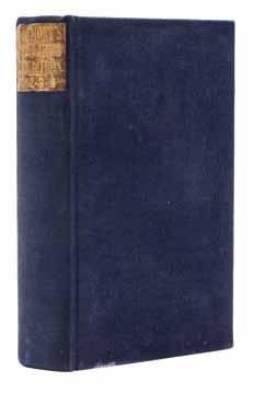
34 30 SOUTHGATE, HORATIO Narrative of a Tour Through Armenia, Kurdistan, Persia and Mesopotamia... New York: D. Appleton, 1840.
2 vols., rebound in 3/4 brown lizard skin over calf, gilt-stamped and -lettered spines. First edition. Complete with five plates, folding map, and engraved plan. Dampstaining to foot of spine, vol. 1, affecting all leaves; intermittent foxing. $700-900
31 (RUSSIAN) KRIZANIC, PETAR PJER Kuku, Todore! Belgrade: Norodua misao, 1927.
4to, rebound in quarter leather over marbled boards, gilt-tooled and -lettered spine, red leather spine label. With original wrappers bound-in. Political cartoon written an illustrated by Krizanic, a Yugoslav caricaturist and founder of the satirical magazine “Hedgehog” (1935). Krizanic is regarded by many as one of the founders of the Serbian and Yugoslav cartoonist movement. Most of his work is political and anti-fascist in nature. $100-200
32 (MIDDLE EAST) EBERS, G. Egypt: Descriptive, Historical, and Picturesque. Translated from the German by Clara Bell. London, Paris and New York: Cassell, 1884.
2 vols. Folio, publisher’s gilt-pictorial brown morocco, a.e.g. First English edition, profusely illustrated throughout in black and white. Wear and fraying to boards at edges; backstrip beginning to detach from text block, both vols. $200-400
33 (MIDDLE EAST, MSS) Three manuscript leaves including a Persian illuminated manuscript leaf (Iran, c. 1800), a Sanskrit Manuscript leaf (India, c. 1800), and a Japanese Buddhist Sutra (Japan, c. 1300). Framed and matted. Size of largest 10 x 3 1/2 inches visible. $200-400
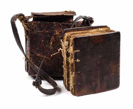
34 (MIDDLE EAST, COPTIC BIBLE) A Coptic bible, the Book of Psalms, 19th-century, hand-written in Ge’ez, text in red and black, handstitched in contemporary wooden boards, 178ff. Housed in brown leather satchel. Some string ties broken; cracking and chipping to some leaves; few leaves detached; modern pen notations throughout. $300-500
35 (MIDDLE EAST, COPTIC PRAYER SCROLL) Manuscript prayer scroll handwritten in Ge’ez in red and black ink, on vellum, illustrated with three colored panels depicting angels and symbols, [19thcentury] Housed in cylindrical metal case with relief form, on metal chain, with cloth tassel. 70 x 3 1/4 inches. $200-400

40
36 (ASIAN) STAUNTON, SIR GEORGE An Authentic Account of An Embassy From the King of Great Britain to the Emperor of China... London: Printed by W. Bulmer for G. Nicol, 1797.
2 vols. only (lacking Atlas vol.) 4to, 3/4 calf over marbled boards, gilt-lettered spines. First edition. With engraved frontispieces and engraved vignettes throughout. Soiling to boards; scattered light brownspotting. $600-800
37 (ASIAN) ORANGE, JAMES The Chater Collection. Pictures relating to China, Hongkong, Macao, 1655-1860; with Historical and Descriptive Letterpress. London: Thornton Butterworth, (1924).
4to, publisher’s gilt-lettered green cloth. First, limited edition, number 304 of 750 copies. With portrait frontispiece, errata slip tipped in, and numerous color plates and maps, some fold-out. Ends lightly bumped and frayed; hinges starting; otherwise fine. $600-800
38 (ASIAN) MICHENER, JAMES Japanese Prints from the Early Masters to the Modern. Rutland, Vermont & Tokyo, Japan: Charles E. Tuttle, (1959).
4to, publisher’s tan and red silk, gilt-lettered spine, original dust jacket. Housed in original cardboard slipcase with printed pictorial title label. First edition. Soiling and rubbing to slipcase; minor chipping to edges of jacket. $100-200 39 (ASIAN) Four color plate books including Guan Yu Was Studying the Book “Spring and Autumn” at Deep Night; Biographies of the Celestial Beings on the Flat Peach Efte; Long-Established Customs at Chinese Festivals; and A Book of Famous and Beautiful Chinese Ladies from all Antiquities. S.l., s.n., n.d. [c. 1930]
4 vols. 8vo, uniformly bound accordion-style in brown silk covered boards, title labels printed in Chinese. Housed in decorative slipcase. Text in English and Chinese. With 10 hand-colored, blockprinted illustrations on silk in each vol. Soiling to slipcase; light rubbing to boards. $100-200
40 (ASIAN, MAO ZEDONG) Mao Zhu Xi Yu Lu. (Quotations of Chairman Mao, “Little Red Book.”) Compiled and edited by Tian Xiao Guang. Peking: The Central Intelligence Bureau of the Chinese People’s Liberation Army, (1964).
12mo, flexible plastic red vinyl dust-jacket with embossed title and Red Star to upper cover. First edition, with half-title printed in red, title printed in green and red, sepia-toned portrait of Chairman Mao, and Lin Biao’s calligraphic endorsement (“Study Chairman Mao’s writings, follow his teachings and act according to his instructions”) in black ink. Second binding, simultaneously printed with copies in first paper wrappers, but the vinyl took longer to produce and was thus released shortly after. Paper wrapper copies were intended for Army officers whereas those in red vinyl were produced to be shared by brigades of up to eight soldiers. Light soiling to jacket; ownership stamp in red to f.f.e.p.; brownspotting to endpapers. $1,000-2,000 41 (ASIAN, MAO ZEDONG) The May 7th Collection of Terms & Expressions (Chinese-English). [Wuhan, Hubei Province:] Revolutionary Committee of the Foreign Languages Department for the Revolutionary Committee of Central China Normal University, 1968.
8vo, original red vinyl jacket lettered in silver gilt with illustration of the Nanjing Yangtze River Bridge in silver to upper cover. First and only printing of this Cultural Revolution dictionary created for use as a tool and supplementary aid for studying the “Little Red Book,” and used by high-ranking soldiers in dealing with foreign visitors and reporters to provide English translations for Mao’s quotes, slogans, and poetry. The title was taken from a speech made by Chairman Mao on May 7, 1966, in which he declared that all intellectuals should be re-educated by the peasantry. Rubbing and light soiling to jacket with some marginal chipping; contemporary ink inscription to f.f.e.p.; light soiling to some leaves; hinges starting. $800-1,200

42


44 42 (VIEWS, NORWAY) Views of Norway. Selected by Tom Olsen, 1895. S.l.: s.n., [1895]
Oblong 4to, brown morocco. An album of 63 mounted albumen prints, depicting mostly landscapes, fjords, town scenes, and people. Photographers include Axel Lindahl and K. Knudsen. Boards worn and reinforced with tape on spine; original spine lacking; minor soiling throughout. $200-400
43 (VIEWS, ITALY) SPERLINGEN, CATHARINA Two hand-colored copperplate engravings depicting landscape views by Catharina Sperlingen and Johannis Jocobi, c. 1730. Matted. 15 x 9 3/4 inches each. $100-200
44* (ROYAL NAVY) KERR, ADMIRAL ROBERT N. A fifty-page bound letter from Admiral Robert N. Kerr (1806-1886) to his son Alexander Robert Kerr (1844-1872), written on February 24th, 1857, as Alexander was about to enter the Royal Navy. 8vo, 3/4 brown calf over marbled boards.
In this letter Admiral Kerr, who had been in the British Navy for over 37 years, writes to his 13-year old son with the request to remember “your duty to your God,” including daily prayer, reading of the Bible, following the Golden Rule, and acting gentlemanly by refraining from using bad language.
Admiral Kerr continues to provide practical advice to his son regarding how to behave on a ship, including avoiding “anything like slovenliness in your dress whilst on watch or otherwise,” proper care of uniforms, proper saluting, proper safety and tips for handling a boat, such as “never attempt to sail with a drunken man in it.”
Intermittent light brownspotting. $300-500

45

47
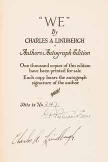
45 LINDBERGH, CHARLES “WE.” New York and London: G.P. Purnam’s Sons, 1927.
Large 8vo, 3/4 vellum over gilt-lettered boards, gilt-lettered spine, pictorial pastedowns. Author’s Autograph edition, number 247 of 1,000 copies signed by Charles Lindbergh and G.P. Putnam’s Sons on the limitation page. With three original etchings, including frontispiece, and numerous photographic plates throughout. Light soiling and dampstaining to upper board; spine slightly cracked; offsetting from original etchings to tissue guards; scattered brownspotting. $600-800 46 CURTISS AEROPLANE CORPORATION The Flight Across the Atlantic. New York: Curtiss Aeroplane and Motor Corporation, 1919.
4to, publisher’s pictorial blue cloth. First edition. Illustrated. Minor soiling to boards. $100-200 47 (SWIGERT, JACK) APOLLO 13 Autographed document signed by the crew of the Apollo 13 Mission (“Fred Haise,” “James Lovell” and “Ken Mattingly”). Program for the dedication of a bronze sculpture of John L. “Jack” Swigert, presented at the United States Capitol, Washington, D.C., May 22, 1997, after Swigert’s death. Ken Mattingly was the original command module pilot of the mission, but was replaced by John Swigert days before the launch due to exposure to the measles. Additionally signed by sculptor Mark Lundeen, Colorado politician Dennis Gallagher and NASA Flight Director Gene Kranz. $600-800


