2 minute read
In Memoriam

Remembering the trails in Rocky most recently touched by fire
photos and story by Dave Rusk
Advertisement
The TRAIL OF THE MONTH will be a regular feature in the monthly HIKE ROCKY Magazine. Each issue we will feature some of the best hikes to take in Rocky, depending on the season and weather developments.
But this month, we remember a few of the trails that have been altered dramatically by the fires of 2020. It’s still too early to know exactly just how much fire damage there was to these trails, but here’s a look back on a selection of them.
Beaver Mountain Loop
Though this is not a commonly-hiked trail, it is an excellent loop hike which affords a variety of good views, including of the recently burned areas of Moraine Park and Upper Beaver Meadows.
Trailhead: Upper Beaver Meadows
Beginning Elevation: 8,440'
Destination Elevation: 10,491'
Total Elevation Gain: 2,051'
Total Roundtrip Miles: 4.6

Upper Beaver Meadows before the East Troublesome Fire
Photo by Dave Rusk
A complete trail profile can be found at the link below
http://www.rockymountaindayhikes.com/beaver-mtn-loop.html

Beaver Mountain Loop GPSmyhike
http://www.rockymountaindayhikes.com/gpsmyhike.html

The upper Big Thompson River flowing out of the Fern Lake Trail into Moraine Park, before the East Troublesome fire.
Photo by Dave Rusk

A fire scar from a 2012 fire above Cub Lake as seen from the Beaver Mountain Loop. Photo taken in 2015.
Photo by Dave Rusk
Fern Lake Trail
The Fern Lake trail includes several popular moderate hikes, including The Pool, Fern Falls, Fern Lake, and The Pool/Cub Lake Loop. The trail had already been impacted by the 2012 fire, but not too much. It appears the 2020 fire has had a much bigger effect, including the destruction of the historic Fern Lake Patrol Cabin. All photos from 2017.
Trailhead: Fern Lake Trailhead
Elevation: 8,155'
Destination Elevation: 9,527'
Total Elevation Gain: 1,372'
Total Roundtrip Miles: 7.6
A complete trail profile can be found at the link below
http://www.rockymountaindayhikes.com/fern-lake-38.html

Fern Lake hike map from GPSmyhike
http://www.rockymountaindayhikes.com/gpsmyhike.html

Fern Lake Trail
Photo by Dave Rusk

Fern Lake
Photo by Dave Rusk

Fern Falls
Photo by Dave Rusk

Cub Lake as seen from Beaver Mountain with 2012 fire scars.
Photo by Dave Rusk
The Tonahutu Creek Trail

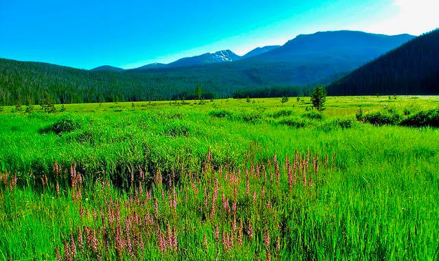
The Big Meadow on the Tonahutu Creek Trail
photo by Dave Rusk
This past summer, I was glad to complete a through-hike starting at Bear Lake on the east side and ending up at the Green Mtn TH on the west side. After cruising across the tundra to Sprague Pass, the trail drops down into the Tonahutu Creek drainage, the very spot where the East Troublesome Fire crossed the Continental Divide.
This stretch of trail is a part of the Continental Divide Trail system that travels through the National Park. The Tonahutu Creek Trail goes by The Big Meadow, Granite Falls and up to the Haynach Lakes alpine basin. The trail had already been impacted by fire some time in the last decade.

Heart-shaped arnica among a previous fire scar on the Tonahutu Trail.
Photo by Dave Rusk

Old fire scars on the Tonahutu Creek Trail.
Photo by Dave Rusk

Just below treeline on the Tonahutu Trail, near Sprague Pass.
Photo by Dave Rusk

Heart-shaped arnica among a previous fire scar on the Tonahutu Trail.
Photo by Dave Rusk

Sprague Pass on the Tonahutu Trail, where the East Troublesome Fire jumped the Continental Divide.
Photo by Dave Rusk

This pocketsized book is perfect for checking out 24 popular hikes within Rocky Mountain National Park. Get your copy at the link below
https://rmconservancy.org/product/rocky-mountain-day-hikes/
