6 minute read
A Wilder Herefordshire: Local Wildlife Sites Sam Price


A Wilder Herefordshire: Local Wildlife Sites
- Sam Price
Advertisement
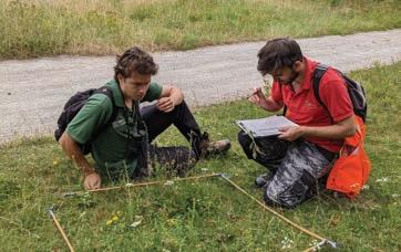
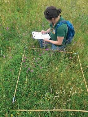
Wildlife Survey Trainee Toby Fountain (left) and Sam Price Nature Recovery Network Officer (right) carrying out a grassland survey (c) HWT
The Project ‘A Wilder Herefordshire’ began in Summer 2021 and runs until 2023. It includes a number of projects which all contribute to nature’s recovery across the country, primarily through increased and improved surveying, monitoring and data collection. This project is grant funded through the Green Recovery Challenge Fund. The Local Wildlife Sites team is one of the sub-projects encompassed by ‘A Wilder Herefordshire’. Local Wildlife Sites (LWS) are areas of land that are especially important for their wildlife. They are some of our most valuable wildlife areas in the UK. LWSs in Herefordshire reflect the county’s local character and distinctiveness and, since first selected in 1990, have played an important role in maintaining and enhancing wildlife in the county by supporting a rich diversity of habitats and providing networks and corridors across our landscape. LWSs are identified and selected locally by partnerships of local authorities, nature conservation charities, statutory agencies, ecologists and local nature experts, using scientifically-determined criteria and surveys. Their selection is based on the most important, distinctive and threatened species and habitats within a national, regional or local context.
LWSs are found on public and private land and include a vast range of semi-natural habitats from species-rich grasslands, ancient woodlands, fens and orchards to rivers and stream
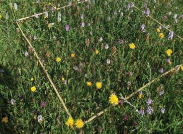
A quadrat in a species-rich area of grassland (c) HWT
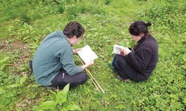
Wildlife Survey Trainees Toby Fountain and Holly Thompson (c) HWT
corridors. They complement the existing statutorily protected sites and form the core of a resilient ecological network. There are close to 750 LWSs in Herefordshire, many of which have not been re-surveyed since their initial selection. The role of the LWS team within the project is to investigate the condition of these sites and to re-establish their pertinent infrastructure and systems within the county. The Team & What We Do
The LWSs team consists of one full time member of staff, the Herefordshire Wildlife Trust’s Nature Recovery Network Officer Sam Price (leading the project since October 2021 until it ends in March 2023), and two part-time Wildlife Survey Trainees Holly Thompson & Toby Fountain (with us since February 2022 to February 2023). Given the state of the LWS system at the start of the project, there was a significant amount of desk-based work to accomplish before the beginning of the surveying season. While the LWS database was made available to us, no ownership information was available. Thus the first action of the project was to gather appropriate resources and use those available to identify the ownership and management of the sites in order to be able to contact land owners to obtain permission to survey. Simultaneously, an appropriate storage system was created on the Herefordshire Wildlife Trust computer system in order to store all generated data for each individual site.
Once the Wildlife Survey Trainees began in February, their initial role was to assist the project’s Wildlife Monitoring & Data Officer Charlotte Bell in the digitization of historic records kept by the Trust in an effort to modernise our data storage solutions. In April, they undertook some desk-based training in the use of the Geographic Information Systems (GIS) being used by the project and plant identification training was arranged with county recorder Stuart Hedley for the whole team, to prepare for the imminent survey season. With their training complete, the team set about contacting landowners, arranging surveys and getting out on site. The first surveys started later that month.
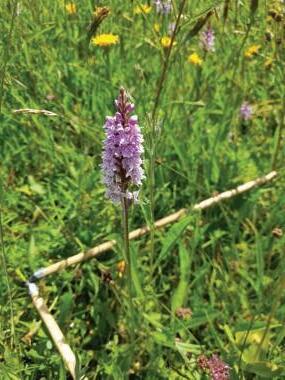
Common spotted orchid captured in a quadrat (c) HWT
Attempts have been made to develop a surveying form, using the ArcGIS Survey123 app, in order to follow lessons learned by Gloucester Wildlife Trust, enabling surveying to be done by skilled volunteers in the future and enabling data to feed directly into GIS systems and reduce the amount of digitizing needed. This is currently a work in progress as the survey form is being actively refined as the team get out and survey. To date, the surveying has focussed on grassland sites as these are some of the most at-risk sites in Herefordshire from unsympathetic management. We are now beginning to diversify into woodland surveys as the grassland season comes to a close. Writing in mid-July, we have so far visited 26 sites and are scheduled to have visited a total of 52 by the end of August. In parallel, our partner organisation, Herefordshire Meadows, is also undertaking to survey and report on a number of potential new grassland LWSs, which will be submitted for assessment
Concurrently, we have also been working on re-establishing the LWS Panel and LWS Partnership within the county. The role of the LWS Panel is to be the decision-making body regarding the creation and development of selection criteria, the evaluation of new and existing sites as well as to advise on national guidance, surveying and monitoring. The role of the LWS Partnership is to support the surveying of existing and potential LWSs and to communicate their importance to the wider community through their stakeholders. The first meeting of the re-established LWS Panel was held in May, persisting since on a monthly basis to evaluate the re-surveyed sites and discuss the selection criteria that are being re-examined and developed to match the contemporary needs of the system. The re-established LWS Partnership is due for its first meeting in September. Over the winter months, as the surveying quietens down, the LWS team will be focusing on the development of management plans for the sites surveyed as well as liaising with the landowners of those sites in order to submit them to the Habitats Index. The LWS Panel will be evaluating the developed criteria against all the survey reports collected in order to adjust the criteria thresholds to an appropriate level to reflect the natural character of Herefordshire.
Holly Thompson completing a survey (c) HWT
The Bigger Picture As a part of “A Wilder Herefordshire”, our project feeds into the development of Herefordshire’s Nature Recovery Strategy. The data that is gathered through the resurveying of LWS will also be ultimately used to feed in to the Nature Recovery Network map and through this we are also able to encourage and support landowners and managers in improving the management of their LWS for the benefit of nature and the communities that may be involved with them. Through the engagement the project generates with different organisations and individuals, we hope to foster the interest and buy-in that will be necessary in order for the LWS system to survive on its own without our intervention as the ultimate goal is for the work we do to outlive the timeline of the project and continue on without our intervention. The training that the Wildlife Survey Trainees receive through this project aids in enabling more individuals to gain the experience needed to break in to the conservation industry in these challenging times. Empowering local people (both Holly & Toby live within the county) to work for the benefit of their local area is greatly beneficial as local knowledge and personal buy-in go a long way in enthusing others about the work that we do.
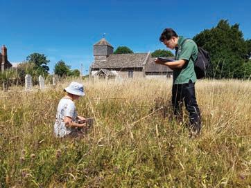
Holly and Toby at St Margaret’s Churchyard in St Margaret’s village, Herefordshire, a Local Wildlife Site (c) HWT


