Geological time
This field guide refers to units of geological time using terms which might be unfamiliar to some people. It is recommended that you download a copy of the time scale (www.sa.gsa.org.au) and consult the relevant sections when necessary.
Introduction
walking trail through geological time
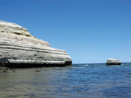
Since late in the 19th Century, the scenically attractive cliff sections at Maslin Bay and Port Willunga have inspired painters, field naturalists and collectors, teachers and students, and geologists and palaeontologists. From about 30 000 to 18 000 years ago Earth’s climate was intensely cold; ice sheets covered much of North America and Europe, the Antarctic ice sheet was at its maximum thickness and extent, and glaciers formed in Tasmania and on the southern highlands of eastern Australia. With so much water frozen in place on the land, sea-levels were 120–130 metres lower than they are today. With the onset of our present globally warmer climate, substantial amounts of glacial meltwater returned to the oceans, which reached present sea-level about 7000 years ago. These coastal cliffs are thus relatively new features that have formed as a consequence of marine erosion. Today the west-facing outcrops are kept fresh by the back-cutting action of the sea and the washing effect of the winter storms. The rocks are all sedimentary strata (layers) and their succession through geological time is readily grasped as one traverses north to south.
The strata offer a glimpse into the Willunga Embayment, the rocks upon which the soils of the McLaren wine region developed. Their broad scientific and environmental significance is high, because no other locality in Australia and very few on the planet display a critical episode in geological time so well. This cycle spanning 42 to 32 million years (myr) ago records the great transformation from a greenhouse world, when polar ice sheets were small or absent, to the icehouse world of today with its substantial ice sheets.
The Willunga Embayment is a relatively small, triangular, downwarped area which is bounded to the north by a high, up-faulted block of very much older folded rocks, and to the south by the high escarpment of the still active Willunga Fault. Along the eastern margin of the parent St Vincent Basin, a series of closely spaced, curved faults, roughly parallel to the Willunga Fault, define and control several similar embayments with matching sedimentary successions. However, the most complete and most easily studied strata are those of the Willunga Embayment which outcrop in the cliffs at Maslin Bay and Port Willunga.
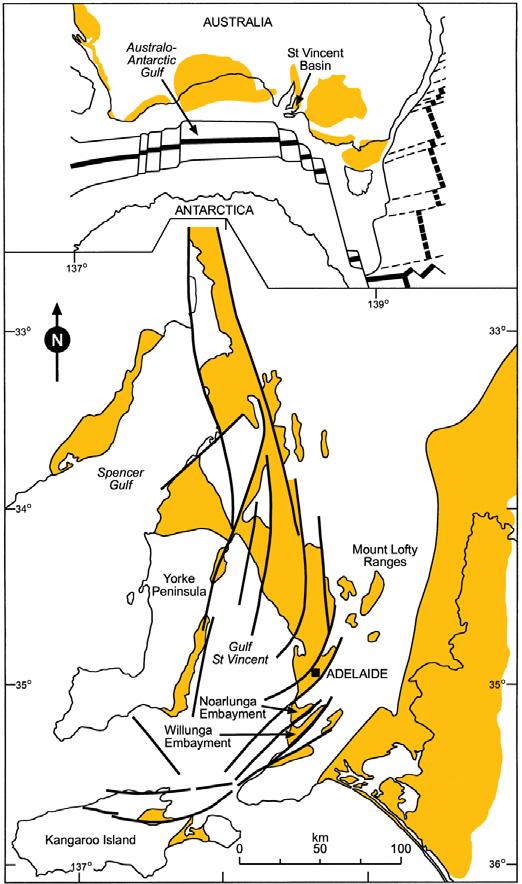
Figure 1 Top: Relative positions of Australia and Antarctica following separation; heavy black lines show the position of the spreading ridge. The landmass that includes New Zealand separated eastwards. Coloured areas signify marine sediments which were deposited within the Australo-Antarctic Gulf that formed between the Australian and Antarctic continents. The position of the St Vincent Basin is shown.
Bottom: The form of the St Vincent Basin is controlled by north-south trending faults, shown as heavy black lines. The basin is bound by the eastern margin of Yorke Peninsula to the west and by the Mount Lofty Ranges to the east. Also shown are the Noarlunga and Willunga Embayments, which lie within the St Vincent Basin.
The Willunga Embayment with its sediment infill is one of several sub-basins on the eastern side of the St Vincent Basin (Figs 1, 3 and 4). The basin and the sedimentary succession which was subsequently deposited therein were initiated when Australia and Antarctica began their rapid separation (continental drift). During Eocene time, 45–42 myr before the present, Australia accelerated its migration to the north (from <2 to >5 mm/year). Changes in the Earth’s stress field reactivated lines of weakness in the region of the ancient Mt Lofty Ranges. The outcome was birth of the St Vincent Basin, now about 42 myr old and currently two-thirds flooded by the modern Gulf St Vincent.
When the St Vincent Basin was born, the incoming sea was a large inlet from the Australo-Antarctic Gulf of the Indian Ocean. At 42 myr ago that gulf had less than 10 myr to live, for it was soon absorbed into the new Southern Ocean as new ocean floor grew rapidly between Tasmania and Antarctica, and the Indian and Pacific Oceans were connected for the first time. There are strong reasons to identify this seaway connection as the beginning of the modern ocean and modern marine life.
Our 19th Century geological pioneers admired these spectacular strata but lacked the grand theories that inform our modern observations. Such theories include plate tectonics, global greenhouse-icehouse change, oceanic circulation, the ages of rocks at the far ends of the Earth, even organic evolution itself.
Access
The geological succession is best walked from north to south, for the strata dip and become younger southwards. As shown on Figure 2, access from South Road is easy. There is a good walking track above the beaches from (1) to (6) and this sector covers most of the geology. The cliff sections are reached easily, the walking is pleasant on the sand with some scrambling over large rocks which can be hazardous when wet. Numerous rock falls illustrate the dangers of getting too close to cliffs. Blanche Point is seen best at low tide, but is generally accessible at most other times.
Maslin Bay
Looking south from Maslin Bay village or anywhere on the cliff or beach, one can observe that the lower strata dip gently towards Blanche Point and Gull Rock. However,
about halfway up the cliff, these gently dipping strata are truncated by an overlying horizontal layer of strongly cemented, in part overhanging sandstone. This angular unconformity represents a 20 myr break in deposition between the Paleogene sediments of the South Maslin Sand, Tortachilla Limestone and Blanche Point Formation below and the Neogene sediments of the Hallett Cove Sandstone above.
Below the angular unconformity
When the Eocene sea swept in, it formed estuaries in the inset valleys into which the South Maslin Sand was deposited (Site 1). Conditions were marine but stressed, probably by low oxygen and low salinity, so marine life was not abundant. However, when a normal, warm sea was established the communities flourished and the limey skeletons are diverse and abundant — bryozoans, molluscs and sea urchins especially but many others too. These conditions produced the richly fossiliferous Tortachilla Limestone sediments, which are best observed at the base of the stepped pathway from the car park at the top of the
Maslin Bay and Port Willunga
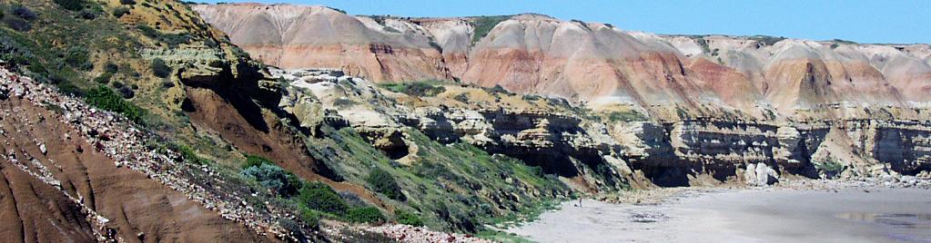
View from Site 2, Maslin Bay, looking south. Eocene South Maslin Sand and Tortachilla Limestone in the foreground, Pleistocene units (see Table 1) in the background. (Photo 409036)
Figure 2 Location of sites along the Maslin Bay and Port Willunga Geological Trail.
cliff (Site 2). Many exposures of this formation are green in colour due to the presence of grains of glauconite, a distinctive mineral that is characteristic of low-oxygen marine environments.
The Blanche Point Formation contrasts strongly with the Tortachilla Limestone, even though it too is rich in fossils (Site 3, adjacent Blanche Point and Perkana Point). Fossils of turreted snails especially are extremely abundant in some layers, intensive burrows in others, sponge gardens in yet others. The unweathered sediments are dark grey (not white as suggested by the word ‘Blanche’) and rich in finely disseminated opal, derived from sponges and diatoms. This points to abundant runoff forming a brackish, low-density surface layer on the sea, inhibiting circulation and gas exchange with the atmosphere. This condition affected the marginal waters of the AustraloAntarctic Gulf whose northern and southern shores were lined with subtropical rainforests in the Late Eocene.
Blanche and Perkana Points separate two beautiful sandy beaches. Blanche Point is floored by the very well cemented Tortachilla Limestone, an Eocene sea floor now being exhumed by the modern sea. To the north the sea erodes the much less resistant South Maslin Sand. Perkana Point is floored by the very hard layers of the Gull Rock Member. Further south the sea erodes the very
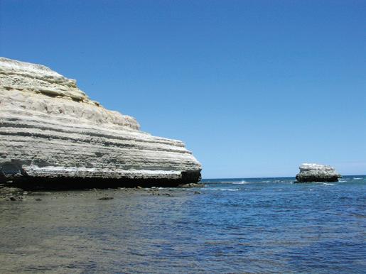
soft Perkana Member. So, the dip of the strata and their varying resistance to erosion determines the shape of the coastline.
Above the angular unconformity
The cemented Pliocene Hallett Cove Sandstone juts out from the cliff and is found in abundant fossiliferous slabs that have fallen onto the beach. Around the coasts of South Australia and locally, it is variable in hardness and fossil content, but its fossils indicate very warm conditions — not as warm as in Eocene time, but warmer than in the following Pleistocene time.
The crumbly, poorly fossiliferous Burnham Limestone, the red-white Ochre Cove Formation and olive-green Ngaltinga Clay, and surface calcrete are also easily viewed from the stepped concrete pathway leading from the carpark to the beach (Site 2). These sediments represent contrasting environments during the Pleistocene Epoch, somewhat warmer and wetter in the earlier part and cooler and drier in the later part. They also reflect the rise of the young (Pleistocene) modern Mt Lofty Ranges, increasing erosion and delivering sediment here and further out into the St Vincent Basin at times of lower sea level.
Port Willunga
The base of the cliffs along the coastline from Blanche Point, south to Port Willunga township, reveal progressively younger strata that were deposited during Late Eocene, then Oligocene time. The top of the Blanche
Point Formation is succeeded by the Chinaman Gully and the Port Willunga Formations. Above the unconformity, the Pliocene Hallett Cove Sandstone, the Burnham Limestone and other younger strata remain accessible.
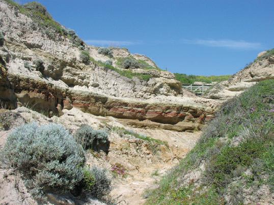
After deposition of the Blanche Point Formation, there are places under Adelaide and on Yorke Peninsula where there were valleys, up to 50 metres deep, cut into the Eocene sediments. These valleys were then backfilled with non-marine sands and muds, before the sea returned. This happened exactly at the time when (on global evidence) the ice sheet on Antarctica first grew to seriously large dimensions and global sea level was lowered accordingly. At Port Willunga this deposition of non-marine sediments is represented by the Chinaman Gully Formation (Site 4).
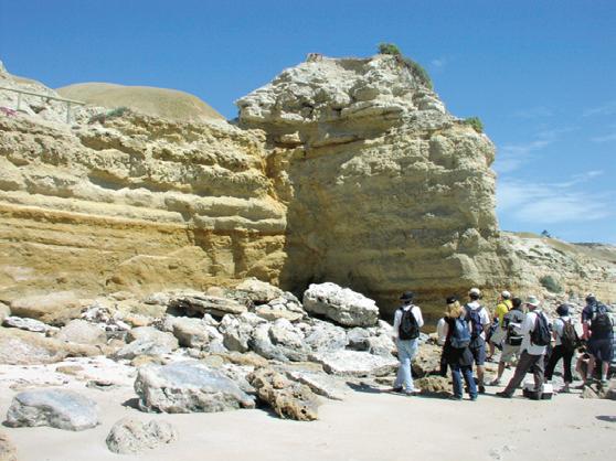
Following deposition of the Chinaman Gully Formation, the sea returned to record a succession of marine environments — shore sands, deeper water sands and muds, increasingly limey (Aldinga Member of the Port Willunga Formation; Site 5). The bryozoan- and echinoidrich fossil assemblages that are preserved in these sediments of the new Southern Ocean are much more like modern shallow-water marine faunas than those of the Blanche Point Formation that lived in the old AustraloAntarctic Gulf. This is strong corroborating evidence that the modern ocean, with stronger water circulation and better ventilated with more oxygen, took a major step forward during this time at the expense of the poorly oxygenated marine environments of the late Eocene. The replacement of sponge gardens by bryozoan gardens is a telling sign of a shift from a greenhouse world in the Eocene to an icehouse world in the Oligocene.
Blanche Point and Gull Rock soon after low tide. The hardened Eocene sea floor on the Tortachilla Limestone is just below the modern sea surface. Lower half of cliff, Gull Rock Member, then the soft, easily eroded Perkana Member. Overhang with patches of deep shadow is the Hallett Cove Sandstone. White at top, Burnham Limestone. (Photo 409038)
Perkana Point, showing Blanche Point Formation (banded Gull Rock and soft Perkana Members). (Photo 409039)
Figure 3 Simplified block diagram of the Adelaide region showing the uplifted fault blocks and sedimentary basins.
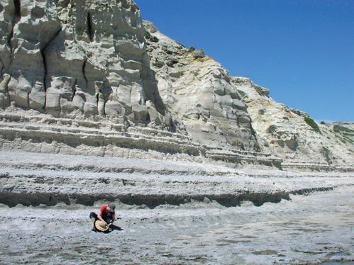
409040)
brown layer at head of tallest figure is displaced upward by about 2 m to the left. Large slabs on beach are fossiliferous Hallett Cove Sandstone, fallen from strata at lowest green bush on skyline. White at top, Burnham
NGALTINGA CLAY
OCHRE COVE FORMATION
BURNHAM LIMESTONE
HALLETT COVE SANDSTONE
RUWARUNG MEMBER
ALDINGA MEMBER
CHINAMAN GULLY FORMATION
PERKANA MEMBER
GULL ROCK MEMBER TUIT MEMBER
TUKETJA MEMBER
TORTACHILLA LIMESTONE
SOUTH MASLIN SAND
non-marine clays, clayey sands, calcrete and other soil horizons: marine limestone at base calcareous sandstone, sandy limestone
bryozoal limestones, silts, clays chert nodules
bryozoal limestones, clays, sands
varicoloured clays, silts, sands hard (silica-rich) and sof (carbonate-rich) layers spicule-rich opal/carbonate/clay
hard (silica-rich) and so t (carbonate-rich)
calcareous glauconitic clay rubbly limestone and sandy ferruginous limestone
ferruginous quartz sands, cross-bedded, glauconic
NORTH MASLIN SAND
cross-bedded quartz sands
clay lenses with terrestrial flora
OLDER FOLDED ‘BASEMENT’ ROCKS CAPE JERVIS FORMATION PERMIAN
sands and clays with pebbles and boulders
Figure 4 Geologic section showing the succession of strata which comprise the rocks of the Maslin Beach and Port Willunga areas. The older folded ‘basement’ rocks and the glacial sediments of the Permian Cape Jervis Formation do not outcrop in the cliff exposures. These units were once exposed in the excavated base of an old sand quarry immediately north of Maslin Beach. This quarry has now been rehabilitated and today none of the stratigraphic units can be observed in outcrop. This diagram should be interpreted in conjunction with the Geological Time Scale (www. sa.gsa.org.au). A wavey line between an underlying and an overlying unit, e.g. Tortachilla Limestone (underlying) and the Tuketja Member of the Blanche Point Formation (overlying), signifies an erosional surface.
Additional sites to visit
An understanding of the geology can be extended at two additional localities, one north and the other south of Maslin Bay:
• A low cutting on the southern side of Chapel Hill Road, 2 km east of Chapel Hill winery, McLaren Vale, where ferruginised sands and gravels of North Maslin Sand overlie deeply weathered white clay,
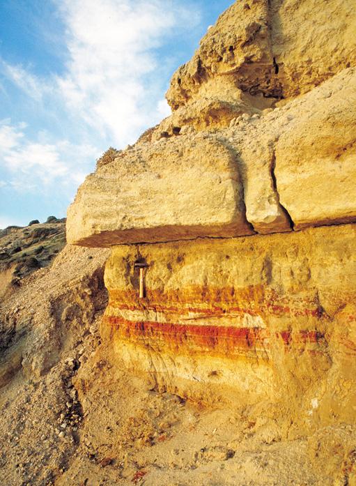
which once resembled the purple siltstones that outcrop at Hallett Cove. The sands and gravels are the oldest sediments in the St Vincent Basin and are not exposed on the coast. The latitude was about 60°S (25° further south than now), but the climate was both warmer and wetter than that of today. Fossil plant remains preserved in fine sediments, exposed in quarries at Maslin Beach and at Golden Grove, signify plant communities which resembled the subtropical rainforests of today. This outcrop is perched above most of the Willunga Embayment due to Pleistocene uplift of the Clarendon-Moana fault block. It was also upstream of the meandering waterways and billabongs of Eocene times, the sediments of which were exposed during sand quarrying.
Cliffs at Port Willunga, north of remains of jetty (off photo to right). The Port Willunga Formation is faulted—the
Limestone. (Photo 409041)
The hard sandstone of the Port Willunga Formation juts out above the Chinaman Gully Formation. (Photo T015640)
Chinaman Gully Formation at Chinaman Gully. This is the brown and green unit separating the Blanche Point Formation (covered under the pink-flowering bushes) from the Port Willunga Formation (flanking the footbridge). (Photo
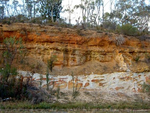
North Maslin Sand, iron-stained to ochre colours, overlies deeply weathered siltstones having an age of about 600 myr. The contact of the two units is an unconformity representing an hiatus of more than 550 million years .Chapel Hill Road, east of Chapel Hill winery. (Photo 409037)
• South of Sellicks Beach, Esplanade south of Gulf View Road, beach walk of~2 km. Here the Port Willunga Formation is exposed at low tide in the shore platform and in the adjacent cliffs. The platform with rock pools is cut into the limestone by the modern sea. The limestones lying unconformably on much older strata have been dragged up to high angles by movements on the Willunga Fault — the boundary between the Willunga Embayment and the Willunga Fault block and associated with the uplift of the modern Mt Lofty Ranges. This uplift caused invigorated erosion and deposition of an alluvial fan comprising gravel, sand and mud, sediments that are exposed in the cliff face above the beach, and which are again being eroded to form the modern beach sediments.
References
Talbot, J.L. and Nesbitt, R.W. 1968. Geological excursions in the Mount Lofty Ranges and the Fleurieu Peninsula. Angus and Robertson, Sydney, 60p.
Acknowledgement
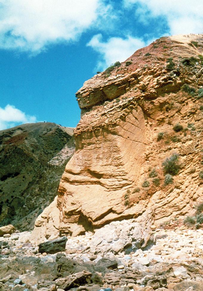
Table 1 Succession of strata
Strata (youngest at top, oldest at bottom) Age (Ma=million years before present)
younger group (flat lying strata ) Neogene (Miocene to Today) Calcrete crust (soil limestone)
Ngaltinga Clay (olive-coloured) probably aeolian
Ochre Cove Formation (red-white mottled) warm and wet conditions
Burnham Limestone (thin crumbly limestone)
Hallett Cove Sandstone (very fossiliferous, large slabs on the beach, sometimes soft sand). Shallow seas, warmer than today, marking the last Neogene warm period before the late Neogene or Quaternary ice age set in after 3 Ma.
Unconformity (low angle, representing a break in the succession—an hiatus)
Pleistocene (<0.5 Ma)
Pleistocene (>0.5 Ma)
Pleistocene (>0.8 Ma)
Pleistocene (~1.7 Ma)
Pliocene (about 3 Ma)
Be prepared when bushwalking:
• Allow at least half a day to walk the trail.
• Wear sturdy shoes, hat and apply sunscreen even during winter months.
• Carry sufficient food and drinking water.
• Safety First! Keep to the defined walking trail except when on the beaches; avoid overhanging rock strata which could potentially fall; stay well back from the tops of cliffs.
• Inform a responsible person of your proposed route and expected time of return.
• Weather conditions can change quickly, ensure you have appropriate wet weather clothing.
• Be advised that the southern end of Maslin Bay is reserved for both clad and unclad bathing.
older group (strata dipping at about 2° to the south)
Port Willunga Formation (sandstones, limestones) Ruwarung Member (above cave ceiling at former jetty) Aldinga Member (below ceiling)
Chinaman Gully Formation (clays with bright weathering reds browns below, greens above)
Blanche Point Formation
Tuit Member (thin, snail-rich, often under sand)
Perkana Member (soft, sponge spicule-rich)
Gull Rock Member (hard, banded, snail-rich layers)
Tuketja Member (thin, green glauconitic)
Tortachilla Limestone (very rich in fossils)
Upper member (green, snail-rich)
Lower member (bryozoan-rich)
Hiatus of ~32 myrs (Maslin Bay) or ~28 myrs (Pt Willunga) or 18 myrs (Sellicks Beach)
Palaeogene (Paleocene to Oligocene)
Late Oligocene (24–26 Ma) Sellicks Beach
Early Oligocene (30–33 Ma) Port Willunga
Earliest Oligocene (33.5 Ma)
Late Eocene (34–36
Ma)
Middle to Late Eocene (37–38 Ma)
South Maslin Sand (sparse marine fossils) Middle Eocene (38–39 Ma)
North Maslin Sand (sands, gravels, clays, rich terrestrial plant fossils in oxbow lakes)
Middle Eocene (40–42 Ma)
Steeply dipping Port Willunga Formation as occurring at the additional locality at the southern end of Sellicks Beach. (Photo T015642)