LOWER RIVER MURRAY
Geological trail
A day’s driving tour observing river landscapes and underlying rocks, Murray Bridge to Blanchetown
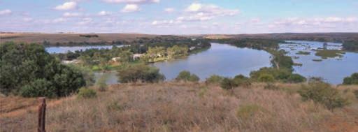
The catchment of the River Murray, the Darling River and their tributaries covers an area of more than a million square kilometres, about a seventh of the surface of mainland Australia (Fig. 1). The catchment receives on average about 6% of the national annual rainfall, but this is extremely variable; both droughts and floods are common. The major rivers are long and flow slowly across semi-arid landscapes of low relief to the lower reaches of the River Murray in South Australia. Along the way, much water is lost by evaporation and this is particularly so in the final flow through the estuarine lakes to the Murray mouth. Since European settlement, river regulation and excessive exploitation have resulted in greatly reduced flows, both upstream of South Australia and within this state, but the River Murray remains a major scenic attraction.
River landscapes
A river is a body of water, often confined to a single channel, flowing from an elevated catchment area to an area of lower elevation, commonly determined by sea level. Rain and/or melting snow and ice in the catchment are the primary sources of river water, but downstream the level of water in the channel is equivalent to the height of the subsurface water table. When catchment inflow is reduced during dry seasons or drought, water levels may fall to expose a dry river bed, but below this surface some flow is often maintained.
Especially in the elevated catchment, a river is an agent of erosion. Erosion is the removal of weathered rock and soil (regolith) from the site of origin; e.g. weathered granite that outcrops in the catchment may yield: granite fragments of various sizes; sand comprising minerals such as feldspar and quartz; and clay. These materials are transported away from the outcropping rocks by the gravity-driven flow of water; the greater the flow rate, the greater the size of the fragments that are transported. In extreme flood events, boulders weighing many
tonnes may be transported; in contrast, barely perceptible river flows are able to transport only the finest particles, commonly clay minerals in suspension. These transported materials are collectively referred to as sediment.
As flow rate decreases, so the transported sediment is deposited. Sediment comprised of the largest fragments, such as cobbles and pebbles, form deposits of gravel; smaller grains are deposited as sand; when river flow effectively ceases the fine material in suspension settles as layers of mud. In the lower tract of a river, the channel is confined within a wide valley, flowing over sediments that were deposited during an earlier time in its history. Particularly where the elevation is close to that of sea-level and day to day flow rates are low, a sinuous pattern of loops or meanders develops (Fig. 2). The outer concave bank of the channel is subject to erosion while sediment can be deposited on the inner convex bank; thus the loop migrates or meanders. Where a river passes through a wider expanse of relatively still water, at the
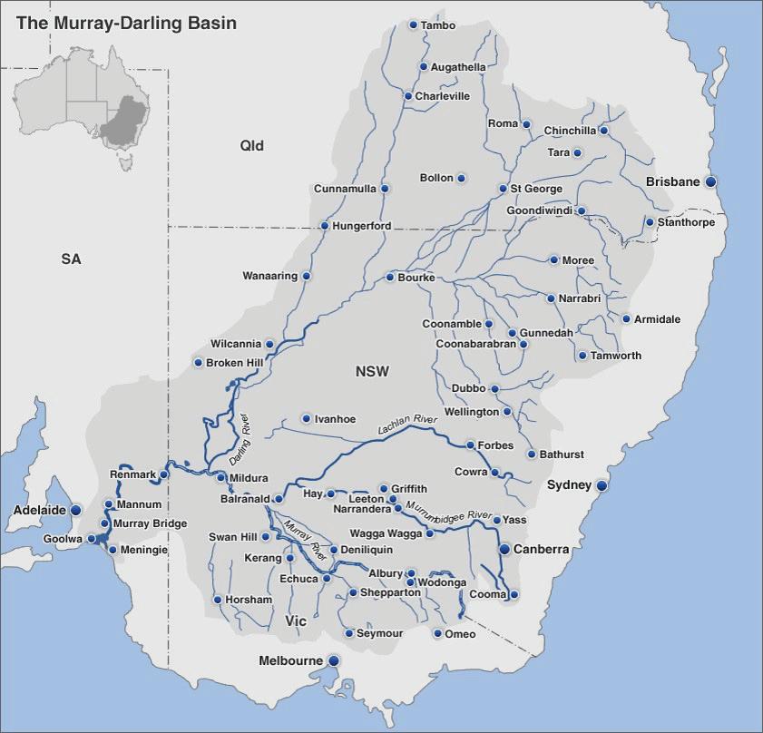
Figure 1 Map showing the extent of the Murray-Darling catchment, culminating in the lower reaches of the River Murray in South Australia.
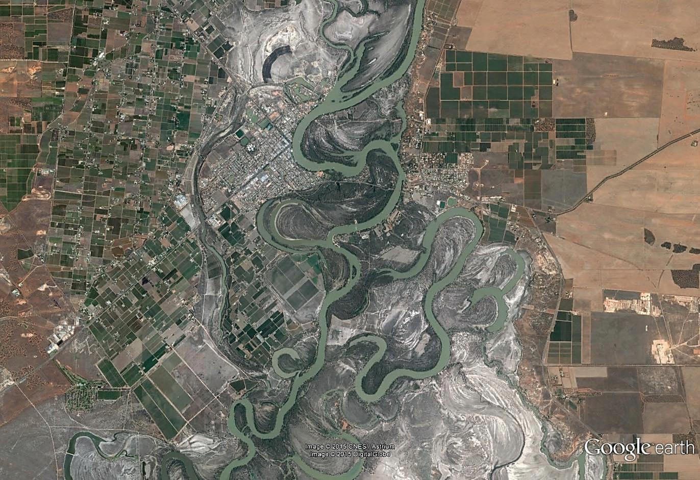
2 Google Earth image of the River Murray and related water bodies in the vicinity of Renmark, South Australia. At this locality the river meanders extensively within a wide valley. As the course of the principal channel has changed, many meanders have been isolated in their positions within an earlier tract of the river, forming loop-like lakes that, in Australia, are known as billabongs.
edges of the main flow where the current is diminished, fine sediment is deposited forming a levée that can be fixed in place by plant growth.
During flood events this pattern of channel development can be rapidly perturbed: swiftly flowing water can slice through the neck of a meander, isolating that part of the channel as a lagoon or billabong (Fig. 2); water over-flowing the banks of the channel at reduced rates of flow deposit their load of transported sediment forming elevated overbank levées; flood waters flow away from these levées, watering wetlands and depositing fine suspended sediment across the floodplain.
Base level, erosion and sedimentation
The elevation of the terminus of a river, commonly sealevel, determines the limit to which a river can erode its valley. However, sea-level has not always been at its present elevation; during the past 125,000 years it has varied greatly (Fig. 3). Thus, about 20,000 years ago, during the Last Glacial Maximum, when sea-level was about 130 m lower than at present, the River Murray flowed across the continental shelf – now submerged, but then exposed –and transported sediment to deep canyons incised into the continental slope (Fig. 4). With this lower base level (-130 m) the river was able to erode a deep gorge-like channel many kilometres upstream of its present site of outflow to the Southern Ocean. In contrast, from 18,000 to 7,000 years ago, as Earth’s climate warmed, ice sheets and glaciers retreated and global oceans rose to their present level. The deepened coastal tracts of rivers, including that of the River Murray, are
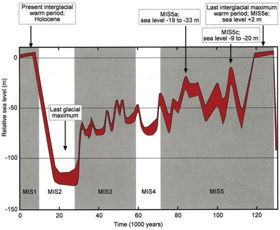
Figure 3 Sea-level curve for the past 130,000 years, in relation to Marine Isotope Stages 1 to 5, derived from observations of flights of coral terraces on the uplifting Huon Peninsula, Papua New Guinea; adapted from Lambeck and Chappell (2001). The thickness of the line of the curve is an expression of the degree of uncertainty of the calculated sea-levels. Numbers 1 to 5 refer to episodes of time (stages) defined by marine oxygen isotope analyses of fossil foraminifera preserved in marine sediments from deep sea cores. The Last Glacial Maximum, when sea-level was about 130 m lower than at present, is shown within Stage 2. The Last Interglacial warm period (within Stage 5) occurred about 130,000 to 120,000 years ago, when sea-level is estimated to have been at least 2 m higher than at present. The present interglacial warm period (Stage 1) has existed for little more than the past 10,000 years. The rapid rise in sea-level during the transition from Stage 2 to Stage 1 is known as the Postglacial Marine Transgression. The last 12,000 years (approximately) constitutes the Holocene Epoch.
described as having been ‘drowned’ and were back-filled with sediment.
The Lower Murray River Gorge/Valley was probably stripped of all sediment infill during the last Glacial Maximum, ca. 20,000 years ago (Jaksa et al. 2013 and references therein). Subsequently, as sea-level rose, thus also raising base level for the river, there was a major switch from an erosional regime, during which a deep gorge-like channel was formed at Swanport near Murray Bridge (Fig. 5), where the profile of the eroded gorge is more than 60 m below present sea-level and further upstream, to a depositional regime. Coarse sandy sediment could no longer be transported beyond the river channel. This coarse river sand is commonly referred to as the ‘lower valley-fill’. Overlying clay, mud and silt were deposited later as sea-level stabilised, ca. 7,000 years ago (Fig. 6).
Figure
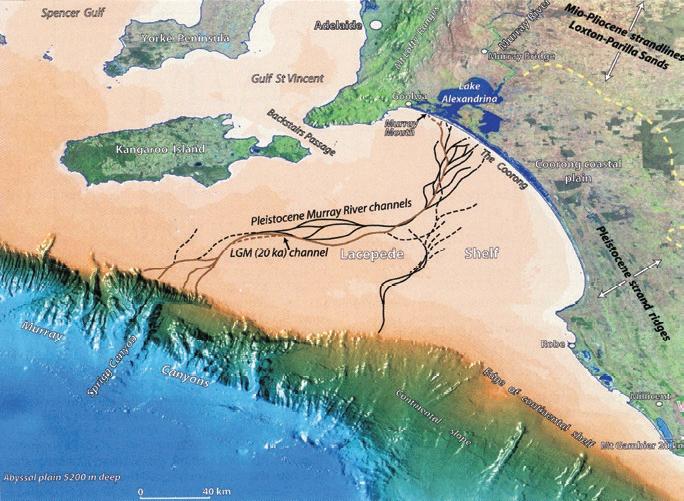
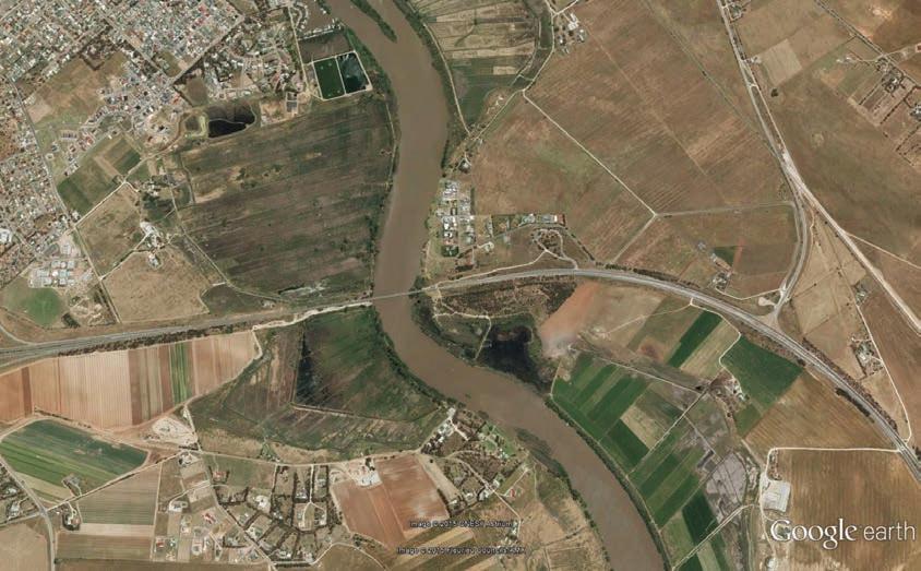
Figure 4 Three dimensional, oblique view, looking north, over the Lacepede Shelf region and River Murray palaeochannels; Last Glacial Maximum (LGM) channel in brown. The wide continental shelf (light brown/fawn colour) dips very gently seaward to a depth of about 200 m at the shelf edge, beyond which the continental slope, deeply incised by canyons, descends steeply to a flat abyssal plain at 5200 m. During major glaciations in the Pleistocene, the Lacepede Shelf was an expansive coastal plain across which the palaeo-River Murray flowed, initially southward, then roughly west-southwest and into the head of Sprigg Canyon (Hill et al. 2009). Centre of plan approximately -36.39°, 138.38°.
Stratigraphy of the Murray Basin
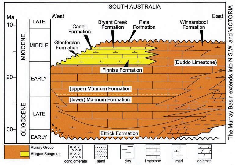
The term ‘Murray Basin’ refers to an extensive saucer-like depression and its contained sedimentary succession that developed in the Cenozoic Era following the break up between Antarctica and the southern margin of Australia. The basin is named after the River Murray, which has eroded and revealed parts of the sedimentary succession in valley-wall cliff exposures. Between Murray Bridge and Blanchetown, sedimentary successions of Miocene age are exposed in cliff sections (Fig. 7).
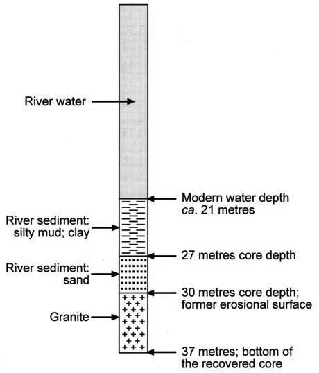
Figure 6 Mid-river geological section revealed by a core taken at the Swanport Bridge site (Fig. 5). At the time the core was taken, river water depth was reported to be 21 m. The upper package of river sediment, 21-27 m, comprises clay, mud and silt. These sediments were deposited under conditions of reduced river flow after culmination of the postglacial sea-level rise, about 7000 years ago; the river was then at modern base level. The lower package of river sediment, 27-30 m, comprises sand that was being transported at times when the river flowed more vigorously; sea-level (and therefore base level) was then lower (Fig. 3). As sea-level rose, thus raising base level, the sand could not be transported further; it remained as a stranded sedimentary deposit. Finally the core records 7 m of granite. Observations in the local area and elsewhere reveal that this igneous rock extends to crustal depths of at least several kilometres.
Field travel
Depart Adelaide driving via the South Eastern Freeway towards Murray Bridge. Driving time to the Swanport Bridge (Fig. 5) is approximately one hour.
Site 1: Murray Bridge Granite at Swanport Bridge
Figure 5 Google Earth image showing location of the Swanport Bridge crossing the River Murray, downstream of the town of Murray Bridge. In preparation for the construction of this bridge, the subsurface geology was determined by physical coring (Fig. 6) and seismic methods.
On the Adelaide side of the river and close to the bridge on the upstream side, there is a conspicuous outcrop of Murray Bridge Granite. This outcrop has not been included as an ideal site for this field guide as there is no designated parking area away from the road traffic and there is no footpath. However, for those who have a special interest in granitic rocks the outcrop is worthy of inspection; park your motor vehicle well off the shoulder of the road before reaching the constructed approach
Swanport Bridge
to the bridge and walk to the outcrop; allow at least half an hour for the return walk. This exposure of Murray Bridge Granite exhibits large, distinctively zoned feldspar crystals (rapakivi texture) and an aplite dyke. Murray Bridge Granite originated as one of many igneous intrusions (plutons) into the Adelaide Fold Belt about 500 million years ago.
After crossing the River Murray, take the signposted road (Princes Highway) towards Murray Bridge. After about 7 km this road crosses the river (becoming Bridge Street) into the central part of town. Drive 0.6 km to the intersection of Bridge Street and Mannum Road; turn right towards Mannum (Route B35). Follow this road for about 20 km to the intersection with Caloote Road; turn right and drive for about 3 km towards Caloote. Turn left from Caloote Road into Caloote Landing Road to the western bank of the River Murray. There is ample safe parking.
Site 2: Caloote
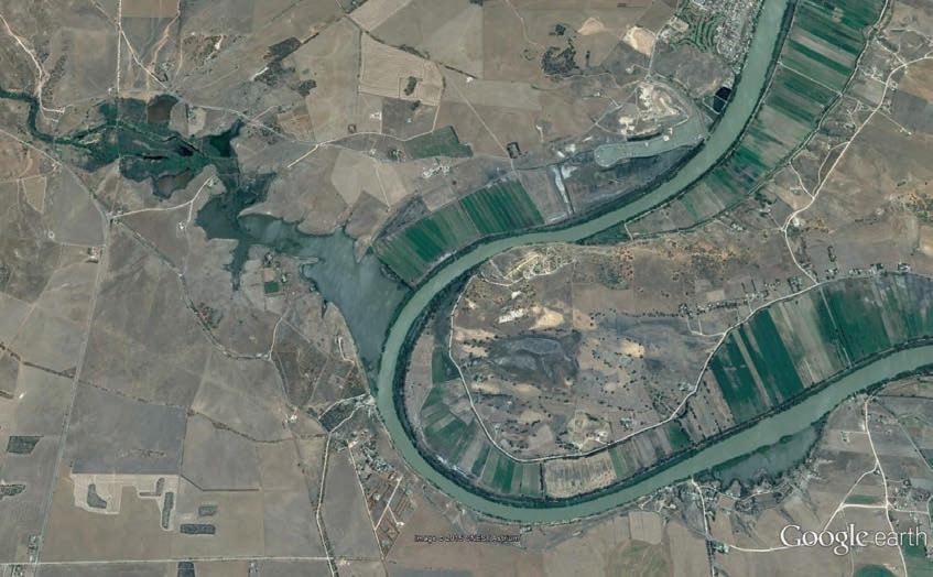
Caloote marks the site of junction of Reedy Creek and the River Murray (Fig. 8). During the Last Glacial Maximum, sea-level was ca. 130 m lower than that of today (Fig. 3). Consequently, at that time, when sea-level (= base level for the river) was lower, the River Murray eroded a gorge-like
valley here that was up to 60 m lower than the modern water surface (Fig. 6). The eroded floor of this gorge defined the base level for the tributary, Reedy Creek, which therefore also eroded a deeply incised valley.
With culmination of the Postglacial Marine Transgression and consequent development of the modern river, the lower valley of Reedy Creek was flooded to the prevailing water level of the River Murray; such a valley is sometimes described as ‘drowned’. Subsequently, sediment derived from upstream erosion of granitic and metamorphic rocks has partly infilled the Reedy Creek valley forming the wetlands on the eastern side of Mannum Road. A levée defines the western edge of the River Murray, where the marginal flow of the river interfaces with the still water of Reedy Creek, thus promoting deposition of sediment.
Return to Route B36 and proceed to Mannum, where there are shops, various dining options and a pleasant picnic area by the river, with free car parking and toilet facilities.
Site 3: Mannum
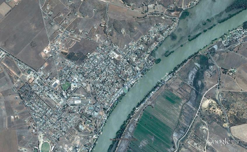
The infrastructure of Mannum (Fig. 9) is largely confined to the north-western side of the river, on Miocene limestone, above flood level; extreme flood events inundate lower
parts of the town. On the opposite south-eastern side there are extensive areas of flood plain where river sediments have been deposited. Irrigated agriculture is a feature of these areas.
All vehicular traffic must use the ferry service to cross the river at Mannum. Cores reveal sections below the river that are similar to that shown for the Swanport location (Fig. 6). Very long piers would be required to support a bridge suitable for road traffic, which on the south-eastern side would need to extend beyond the flood plain to the outcropping Miocene limestone. Construction of such a bridge would be expensive; to date there are no plans to replace the ferry.
Site 4: Midden with freshwater mussel shells
After crossing the river, drive upstream along Hunter Road for 1.3 km and turn left into East Front Road, which is close to the south-eastern margin of the river. Proceed for a further 1.85 km to an intersection with an unsurfaced farm road where a roadside excavation has exposed a deposit of freshwater mussel shells (Fig. 10). Take care to avoid further disturbance of this site and do not collect or otherwise remove shells or other materials.
Figure 7 Summary of the stratigraphy of sedimentary successions that are exposed in cliffs of the River Murray between Murray Bridge and Blanchetown; from Cowley and Barnett (2007).
Levee
Reedy Creek
‘Drowned’ valley of Reedy Creek
RoadCaloote
Caloote
Mannum Road
South to Murray Bridge
Irrigated flood-plain
RiverMurray
Figure 8 Google Earth image showing features of the River Murray in the vicinity of the village of Caloote. Shown in this image is the site of junction of Reedy Creek and the River Murray, marked by a well-defined levée that formed by sediment deposited at the interface of the active flow of the river and the still water of the ‘drowned’ Reedy Creek.
The shells are those of a species of mussel that currently inhabits the backwater lagoons of the River Murray, Velesunio ambiguus; there are reportedly many related Australian species that have similar shells. Prior to European settlement, freshwater mussels were an important food item for people living along the River Murray. Deposits of shells, other food remains and additional evidence of former human occupation are described as ‘middens’. Radiocarbon analysis of shell from this midden yielded an age of about 4,000 years (3990 ± 50 yr BP; laboratory code Wk-7428).
Return back along East Front Road to Hunter Road and turn left; drive 2.6 km to the intersection with Bakers Hut Road; turn sharp left and proceed downhill to the T-junction at the edge of the river at East Front Road. Park your vehicle and walk along the bitumen downstream through the road closure.
Site 5: Riverbank slumping
In many places along the river, the river banks comprise muddy sediments that were deposited during earlier constructive phases. When water levels are high these muddy banks remain essentially coherent; water plays an important role in maintenance of this condition. During the prolonged drought of the first decade of the 21st century, water levels along the River Murray were extremely low. Consequently,
muddy river banks became dehydrated and weakened. Large blocks of the sediment slumped away from the banks, sometimes taking whole trees and infrastructure with them, collapsing beneath the water (Jaksa et al. 2013). The road at this site was constructed on muddy sediments of the river bank; during the drought the early signs of bank collapse appeared as arcuate cracks. Initially these cracks were ‘patched up’ with bitumen; the evidence of these attempted repairs can be seen as extended, curved bitumen infillings of the road surface. Subsequently it was appreciated that the road was in danger of collapse and it was closed to traffic.
Site 6: Mannum granite quarry
Continue walking along the road for about 500 m to the Mannum granite quarry. While it is safe to examine the rocks that are exposed in the quarry face from the floor of the quarry, do not attempt to climb on the face; also, exercise extreme care if walking across the surface rocks (limestone and calcrete) close to and above the face of the quarry. Children should be closely supervised.
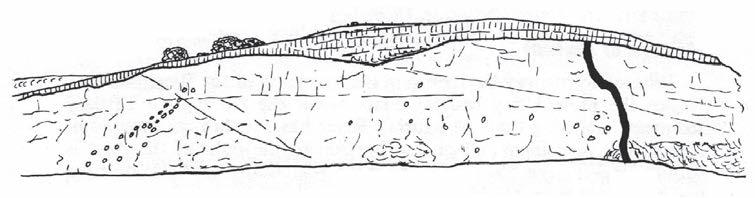
Like the Murray Bridge Granite at the Swanport Bridge, the granite exposed in this quarry originated as one of many igneous intrusions (plutons) into the Adelaide Fold Belt about 500 million years ago. The rock crystallised from molten material (magma) at a depth of several kilometres. Exposure of the granite at the surface implies that this thickness (at least) of overlying rock has been removed by erosion. Features of interest are indicated on the sketch (Fig. 11) from Talbot and Nesbitt (1968) and summarised below.
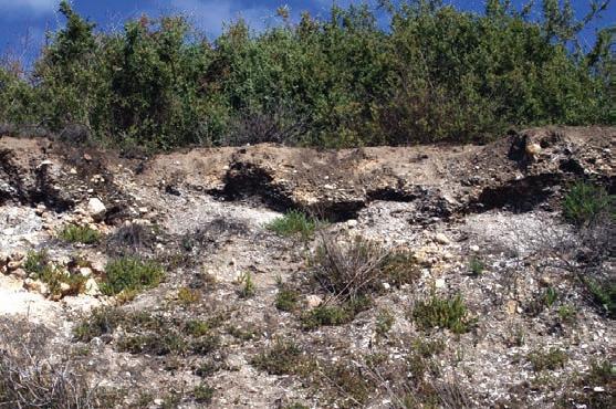
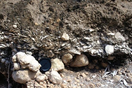
Top General view of the exposure.
Bottom Detail of the shell deposit; diameter of the lens cap for scale is 53
Granite: coarsely crystalline, signifying that the parental magma cooled very slowly; pink feldspar (orthoclase) is the dominant mineral, with glass-like quartz and smaller amounts of black mica (biotite). Dating of this rock yielded an age of 475 ± 6 million years (Clark and Cook 1983).
Xenoliths: the dark masses are pieces of the pre-existing intruded rock that were engulfed by the granitic magma. Close inspection reveals that many of these xenoliths contain pink feldspar crystals, evidence of their partial assimilation by the magma. There are no obvious indications of the original composition of these smaller clustered xenoliths, but they might have been metamorphic rocks of the Adelaide Fold Belt, as indicated by a very large xenolith at the other (downstream) side of the quarry.
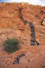
Dyke: the dark, fine grained rock mass extending vertically across the face of the quarry is another igneous rock; it is closely similar in appearance and chemical composition to
Ferry crossing
Caloote
Irrigated flood-plain
RiverMurray
Figure 9 Google Earth image showing features of the River Murray in the vicinity of the town of Mannum.
Figure 10 A low roadside excavation exposes a dense accumulation of freshwater mussel shells (midden) in a matrix of dark grey soil containing fragments of charcoal.
mm.
of overlying rock has been removed by erosion.
the common volcanic rock ‘basalt’. While it is obvious that the dyke is relatively younger than the granite, dating of the dyke rock yielded an age of 474 ± 6 million years (Clark and Cook 1983), numerically indistinguishable from the age of the granite. Microscopic examination of the dyke rock reveals mineralogical evidence that the initial change from liquid magma to solid rock was followed by a prolonged period of high temperature.
Limestone: As shown in Fig. 11, the sandy limestone overlies and truncates the dyke, evidence that it is younger than both the dyke and the granite. Fossils of marine invertebrate organisms preserved in the limestone are evidence of a Miocene age for the sediment. The smooth, wave-abraded surface of erosion between the older igneous rocks and the younger sedimentary rock is an ‘unconformity’. The floor of the quarry is littered with fragments of the limestone, some of which include numerous fragments of scallop shells. These fossils provide evidence of a shallow
marine environment in which energetic coastal waves smashed the shells into small fragments and sorted them according to shape and size. Similar sediments can be observed in equivalent modern settings.
Calcrete: The calcium carbonate of the Miocene limestone is subject to solution and redeposition, especially in the prevailing Mediterranean climate. During a typical wet winter, rainwater infiltrates the limestone and some of the calcium carbonate dissolves. In contrast, during the following hot dry summer, surface evaporation promotes precipitation of carbonate minerals. Repeated seasonal wetting and drying of limestone in the Mannum area has resulted in calcrete, a surface capping of distinctively different appearance. Often the carbonate minerals have seasonally precipitated around nuclei forming spherical structures that internally resemble those of onions.
Return to your vehicle and proceed upstream along East Front Road (adjacent to a lagoon that is separated from the main river by a levée) for 1.1 km to a quarry exposing Miocene limestone (Fig. 12). Park at the roadside and walk slowly into the quarry, observing materials adjacent to the pathway.
Site 7: Quarry in Miocene limestone
Scattered freshwater mussel shells close to the roadside are remnants of a midden. To the left of the path there is a fine example of the smoothed, wave-abraded surface of the eroded granite that unconformably underlies the sandy limestone. Continue walking the short distance to the floor of the quarry where the excavated face can be studied. The sedimentary strata are undeformed; they are comprised of the shelly parts of marine organisms that inhabited the shallow Miocene sea. Fossils include several species of sea urchin (= echinoid), notably a heart urchin Lovenia forbesi (Fig. 13a).
Return to your vehicle and continue driving upstream along East Front Road, which follows the river and associated lagoons at river level.
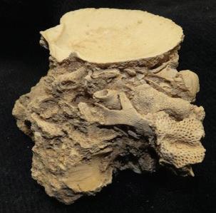
Figure 12
a. General view of the limestone quarry from the roadside; person indicated for scale.
b. A specimen of the limestone comprised of the carbonate hard parts of marine invertebrate fossils. Bryozoan remains are a major fossil constituent of the limestone.
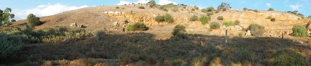
Figure 13 Examples of some marine fossils that are commonly preserved in exposures of Miocene limestone in cliffs along the River Murray:
a. Heart urchin (echinoid; Lovenia forbesi)
b. Sand dollar (echinoid; Monostychia australis)
c. Lamp shell (brachiopod; Victorithyris garibaldiana)
d. Scallop shell (bivalve mollusc; Chlamys murrayana)
These and other invertebrate organisms that are preserved as fossils in the limestone provide evidence of a warm, shallow marine sedimentary environment.
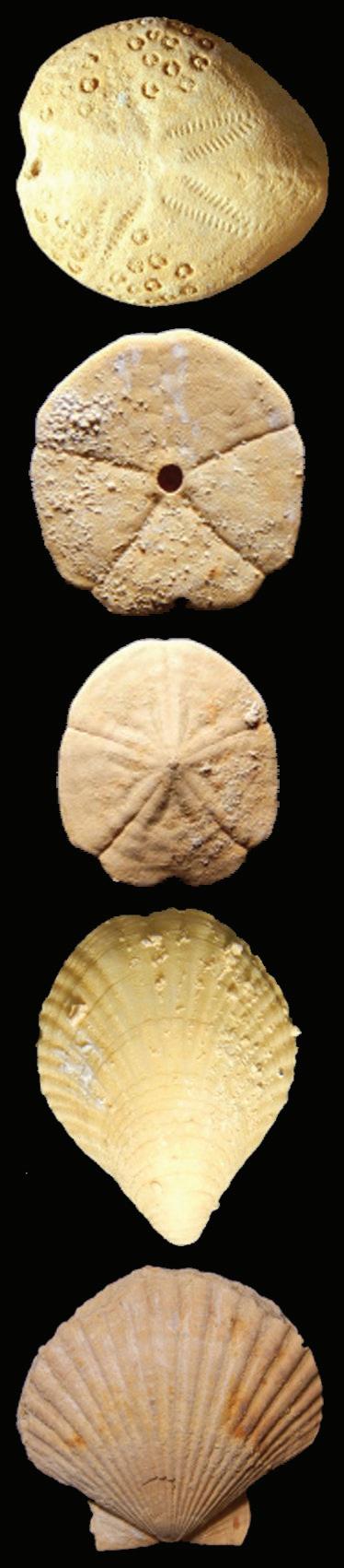
Figure 11 The granite exposed in this quarry is an igneous rock that crystallised from molten material (magma) at a depth of several kilometres. Exposure of the granite at the surface implies that this thickness (at least)
Miocene limestone Calcrete capping on limestone
Xenoliths in granite
Sketch of part of the quarry face from Talbot and Nesbitt (1968)
Granite
Dyke in granite a
Site 8: Lookout over Teal Flat
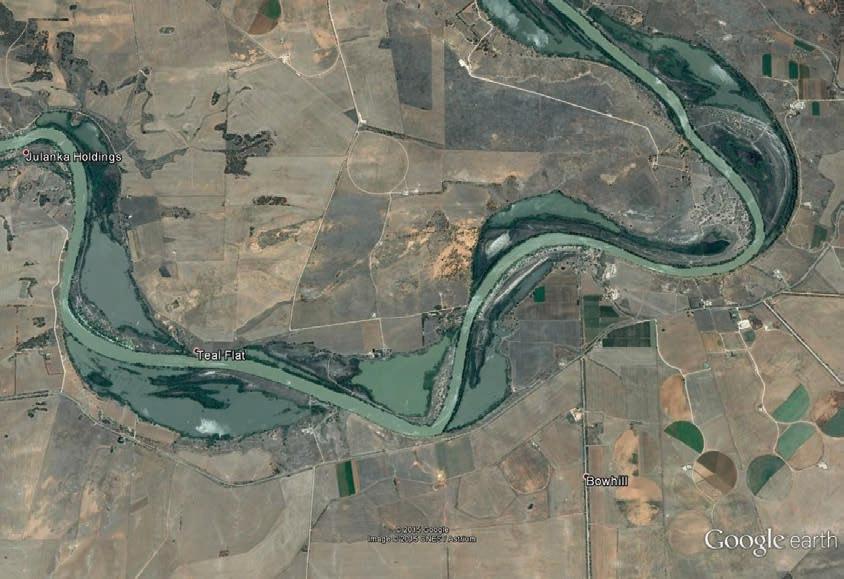
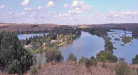
After about 20 km the road rises steeply to a junction with Hunter Road. Before reaching this intersection, stop at the signposted lookout where there is safe off-road parking. This elevated site overlooks the river and its associated meanders, levées and lagoons (Fig. 14). The River Murray is confined by elevated, well defined sides of the valley. Within these limits, the river has widened its valley and persistently meandered. At the edges of the main flow, where the water is relatively still, sediment has been deposited forming levées. In modern time, lower water levels and reduced flows due to river regulation have contributed to the exposure and vegetation of these features. Lagoons of partly isolated still water occur between the levées and the sides of the valley.
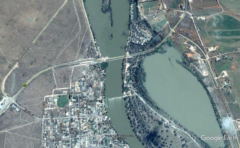
Resume driving to the intersection with Hunter Road and turn left, driving eastward. The elevated road generally follows the upstream course of the river, turning north and becoming Swan Reach–Walker Flat road and then Blanchetown–Swan Reach road. Follow this road to the intersection with the Sturt Highway (A20). Turn left towards Blanchetown and drive across the river; an older, now abandoned bridge is on the left, downstream. On the western side of the river the vehicular approach to the old bridge is now a car park and driver rest site. Turn into this area and park your vehicle. This is Site 9 (Fig. 15).
Site 9: Old Road Cutting, Sturt Highway, Blanchetown Bridge
The sedimentary rocks exposed in the cutting are shelly limestones of the Glenforsian Formation, of early Middle Miocene age (Fig. 16a). The marine invertebrate fossils include
Figure 14
a. Google Earth image of the area known as Teal Flat. Meanders and levées feature in this river landscape.
b. View from the scenic lookout at Site 8.
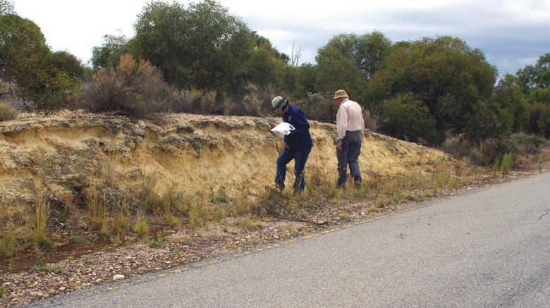
16
a. Roadside exposure of the Glenforsian Formation, western side of the River Murray, old road cutting, Sturt Highway, Blanchetown.
b. Detail of shelly sediment; diameter of lens cap for scale is 53 mm.
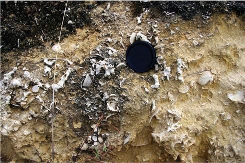
Figure 15 Google Earth image of the River Murray at Blanchetown showing the locations of Sites 9 and 10 and features mentioned in the text.
Meander
Earlier meander
Lagoon
Lagoon Trees grow on levees
Site 9 Site 10
Figure
brachiopods (lamp shells), bryozoa (including lace-like sheets and more massive structures), bivalve molluscs (oysters and scallops), echinoids (sand dollars) and foraminifera (single cell organisms generally of microscopic size). The relatively large –up to several millimetres diameter – foraminifer Lepidocyclina sp. is evidence of a warm (tropical), shallow, low-energy sea; the abundance of this species marks the peak of the warm Miocene climatic optimum, 17 to 15 million years ago. The bryozoan Celeporaria sp. provides supporting evidence of this marine environment. These marine fossils are most easily observed in the exposures where the finer sediment has been removed by weathering (Fig. 16b).
Return to the Sturt Highway (A20); turn left and drive about 200 m to the signposted turnoff to the town of Blanchetown. Follow the signs to the boat ramp at the edge of the river where there is adequate parking and toilet facilities. Walk the short distance to Site 10.
Site 10: Abandoned bridge, Blanchetown
This site is the section exposed beneath the abandoned bridge (Fig. 17).
Figure 18 describes this stratigraphic section.
Site 10 completes the field observations.
Return to Adelaide via the Sturt Highway (A20) or continue your journey towards Renmark.
References
Clark IF and Cook BJ (editors) 1983. Geological Science Perspectives of the Earth. Australian Academy of Science, Canberra.
Cowley WM and Barnett SR 2007. Revision of Oligocene–Miocene Murray Group stratigraphy for geological and groundwater studies in South Australia. MESA Journal 47:17–20.
Hill PJ, De Deckker P, von der Borch C and Murray-Wallace CV 2009. Ancestral Murray River on the Lacepede Shelf: Late Quaternary migrations of a major river outlet and strandline development. Australian Journal of Earth Sciences 56:135–157.
Jaksa MB, Hubble TCT, Kuo YL, Liang C and De Carli EV 2013. Riverbank collapse along the lower River Murray - Literature Review. Goyder Institute for Water Research Technical Report Series No. 13/15, Adelaide, South Australia.
Lambeck K and Chappell J 2001. Sea level change through the last glacial cycle. Science 292:679–686.
Steel RD 1968. South East Freeway – River Murray crossing near Murray Bridge: Geological Investigations - Progress Report No.2 Feasibility and Site Selection Stage. Department of Mines South Australia, 66/46.
Talbot JL and Nesbitt RW 1968. Geological excursions in the Mount Lofty Ranges and the Fleurieu Peninsula. Angus and Robertson, Sydney.
Twidale CR, Lindsay JM and Bourne JA 1978. Age and origin of the Murray River and Gorge in South Australia. Proceedings of the Royal Society of Victoria 90:27–42.
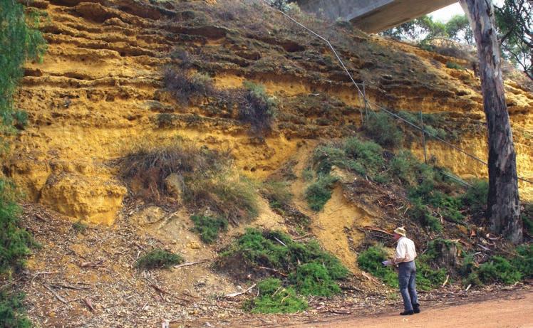
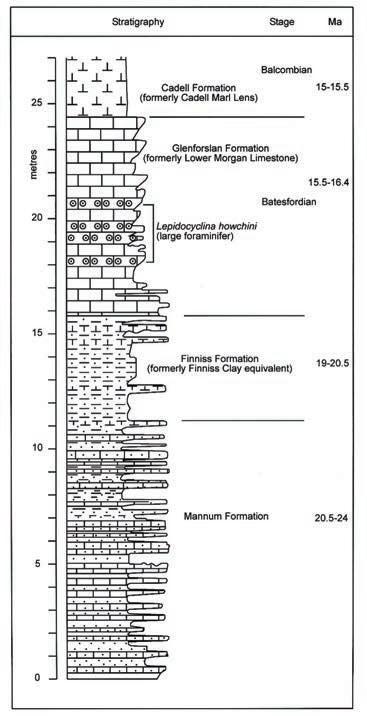
Figure 17 Succession of Early to Middle Miocene sedimentary rocks of carbonate composition, exposed at Site 10, beneath the bridge crossing the River Murray at Blanchetown. They are variously composed of shells and shell fragments, sand and mud. The original sediments were deposited in warm, shallow seas, as signified by the presence as fossils of such marine animals as sand dollars (Monostychia australis) and foraminifera (Lepidocyclina sp.). The yellowish Mannum Formation forms the base of this exposure; the close regular spacing of the more resistant strata has been interpreted as evidence of cyclic changes in the sedimentary environment. These environmental changes were probably related to climatic events. Figure 18 is a diagrammatic interpretation of this exposure.
Figure 18 Stratigraphic representation of the succession of Early to Middle Miocene sedimentary rocks of carbonate composition at Site 10 (Fig. 17). The regular close spacing of the more resistant beds within the Mannum Formation has been interpreted as evidence of cycles of environmental change, probably in response to changes in Earth’s climate. Detailed investigation of the sediments and their preserved fossils indicates that each layer records evidence of a waterdeepening event, followed by shallowing to expose the surface sediment above sea-level. Such inferred changes of sealevel can be explained in terms of glacial (low sea-level) and interglacial (high sea-level) cycles in global climate. Such a relationship between global climates and sea-levels, attributed (at least in part) to Earth’s orbital parameters, has been well documented for more recent times (Figs 3, 4).The stage names ‘Balcombian’ and ‘Batesfordian’ are formal timestratigraphic terms. Ma = time in millions of years. Be prepared for your drive:
• This field trip will take a full day to complete. Plan your day allowing sufficient time for field studies, meals and toilet needs; consider summer and winter daylight differences.
• Carry adequate drinking water and ‘snacks’ for yourself and passengers.
• Dress appropriately for forecast weather conditions.
• Even during winter, apply sunscreen and wear a hat.
• Personal insect repellent may be required; a fly net could be useful.
• Ensure that your vehicle is roadworthy and has sufficient fuel for the distance to be travelled.
• Drive safely; be aware of other motor vehicles, especially when stopping at study sites and when re-entering traffic.
• Be aware of and practise conservation etiquette – ‘leave nothing but footprints, take nothing but photographs’.
Acknowledgement
Original text prepared by Mary-Ann Binnie, William Shackleton and John Cann of the Geological Society of Australia (South Australian Division) and the Field Guide Subcommittee. www.sa.gsa.org.au