DISPLAY COPY
C')
m
C
r-
e
C') C')
> r-
(1)
C
C')
m
-4
-<
C
'TI
> C:
(I)
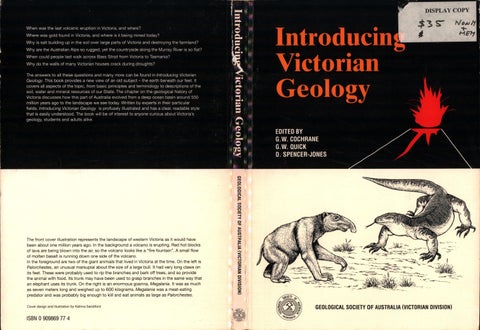
The front cover illustration represents the landscape of western Victoria as it would have been about one million years ago. In the background a volcano is erupting. Red hot blocks of lava are being blown into the air, so the volcano looks like a "fire fountain". A small flow of molten basalt is running down one side of the volcano. In the foreground are two of the giant animals that lived in Victoria at the time. On the left is Palorchestes, an unusual marsupial about the size of a large bull. It had very long claws on its feet. These were probably used to rip the branches and bark off trees, and so provide the animal with food. Its trunk may have been used to grasp branches in the same way that an elephant uses its trunk. On the right is an enormous goanna, Mega/ania. It was as much as seven meters long and weighed up to 600 kilograms. Mega/ania was a meat-eating predator and was probably big enough to kill and eat animals as large as Pa/orchestes. Cover design and illustration by Katrina Sandiford
ISBN O909869 77 4
-4
-.a
>
r-
>
< C')
-4 C
:::D
> z c::,
::5
(I)
C
z
GEOLOGICAL SOCIETY OF AUSTRALIA (VICTORIAN DIVISION)
(i)
Introducing Victorian Geology
Panorama of Bendigo, then known as Sandhurst, 1888. Numerous head frames (also known as poppet heads) can be seen. These were erected over deep mine shafts. At the top of each head frame is a large wheel. A wire cable travelling around the wheel was attached to a cage in which men could be raised or lowered in the shaft. The shaft was also used for hauling ore to the surface. The head frames were erected at intervals across the town along north-south lines as saddle reefs formed along anticlines were opened up for mining by various companies. In the foreground are dumps of mu/lock, i.e. waste sedimentary rock that had to be extracted to reach the gold-bearing quartz reefs. The large building on the left would have housed the battery (crushing plant) and other equipment used to treat the gold ores. The chimneys indicate the buildings where wood was burnt to raise the steam needed to run the machinery. Behind the left hand chimney is a tailings dam, where the quartz sands were sent after the gold had been extracted. (Photograph courtesy of Geological Survey of Victoria).
(iii)
Introducing Victorian Geology Edited by:
G.W. Cochrane G.W. Quick D. Spencer-Jones
Principal authors:
J .N. Rowan (Chapter 2) J .J. Jenkin (Chapter 3) J .A. Webb (Chapter 4) J .G. Leonard (Chapter 6) P.O. Dahlhaus (Chapter 7)
Other authors:
W .D . Birch (Chapter l & 5), G.W . Cochrane (Chapter l & 5), C .R. Dalgarno (Chapter l), R.C. Glenie (Chapter 5), I. W. McHaffie (Chapter 5)
GEOLOGICAL SOCIETY OF AUSTRALIA (Victorian Division), Melbourne, 1991
Qv)
© Geological Society of Australia Incorporated (Victorian Division) 1991. This book is copyright. Apart from any fair dealing for the purpose of private study, research or review, as permitted under the Copyright Act, no part may be reproduced in any manner whatsoever without the written permission of the publisher.
Reference: Cochrane, G.W., Quick, G.W. and Spencer-Jones, D. (Eds), 1991: Introducing Victorian Geology. Victn. Div. geo/. Soc. Aust. pp. 320.
Published by the Geological Society of Australia Incorporated (Victorian Division), P.O. Box 2355V, Melbourne, 3001. First edition I 991 ISBN O 909869 77 4
Registered in Australia for transmission by post as a book.
Available from the Publications Officer Victorian Division, Geological Society of Australia, P .O. Box 2355V, Melbourne, Victoria, 3001.
Editorial enquiries to: G.W. Cochrane, 5 Twisden Road, Bentleigh, Victoria, 3204, Telephone (03) 557 1606.
Diagrams and maps drawn by Denise Russo, Susan Drummond, with additional drawings by Katrina Sandiford and Owen Smith.
Wholly set up in Australia by Research Publications Pty. Ltd . Printed by Eastside Printing Pty Ltd. Melbourne.
(v)
Acknowledgements
Affiliations of authors and editors
The following individuals assisted in the preparation of this book by providing original material or by reviewing manuscripts: N.W. Archbold, P.F. Bolger, F. Canavan, R.A.F. Cas, W.F. Cole, J .G. Douglas, J.A. Ferguson, P.S. Forwood, D. K.lindworth, M. Learmonth, G. Markovics, R.M. Molesworth, J.L. Neilson, S. Oberman, N.W. Schleiger, A.H.M. VandenBerg, M. Williams. The following companies and company personnel provided the material and illustrations, which are included in the case histories in Chapter 5: Australian Cement Ltd., Bora! Resources (Vic) Pty. Ltd., Brick and Pipe Industries Ltd. (J.A. Ferguson), C.R.A. Exploration Pty. Ltd. (T.W. Dickson), Darley Refractories Pty. Ltd. (J .H. Smith), Macquarie Resources Ltd. (P. Dowd), Western Mining Corporation Ltd. (M .F. Lenard). Other assistance by: Geological Survey of Victoria (Department of Manufacturing and Industry Development), P .L. Atkinson, C. Laughton, G. Krummei, R.J. Nott, G.C. Smith and S.H. Tan. Special assistance with equipment was provided by: CSIRO Division of Building, Construction and Engineering and David Mitchell Ltd. The Association of Australian Palaeontologists kindly gave their permission for the fossils illustrated in Figures 4-23 and 4-46 to be reproduced from the Dorothy Hill Jubilee Memoir. The Victorian Division of the Geological Society of Australia was given generous financial assistance by the following major sponsors: Geological Society of Australia Incorporated BHP Petroleum Pty. Ltd. CRA Limited The Australian Institute of Quarrying Education Foundation Western Mining Corporation Holdings Limited and also by Bora! Resources (Victoria) Pty. Ltd. BP Australia Limited Crushed Stone Association of Australia (Victoria) Incorporated Pasminco (Australia) Limited Ashton Mining Limited Aberfoyle Resources Limited Newmont Australia Limited Sons of Gwalia N.L. Douglas McKenna and Partners Pty. Ltd.
W.D . Birch (Museum of Victoria), G.W. Cochrane (David Mitchell Ltd.), C .R. Dalgarno (Geological Survey of Victoria), P .G. Dahlhaus (Ballarat University College), R.C. Glenie (petroleum geology consultant), J .J . Jenkin (formerly Soil Conservation Authority), J .G. Leonard (Geological Survey of Victoria), I. W. McHaffie (Geological Survey of Victoria), G.W. Quick (CSIRO Division of Building, Construction and Engineering), J .N. Rowan (formerly Soil Conservation Authority), D. Spencer-Jones (formerly Department of Minerals and Energy), J .A. Webb (Latrobe University).
(vii)
CONTENTS FOREWORD
Chapter 1:
(xi)
BASIC CONCEPTS IN GEOLOGY Land use ................ ................ ......... . ..... . ................ ...... . ... ........ . .... l Composition and structure of the Earth .............. ..... .... .... ................ .. .4 Magrna ................ ................ ........ . ..... . ... .. . . .... ................ ........ . 6 Soils ... ... .......... ................ ....... ............ .... ................ . .. ................ ... 6 Nature of soils .......... ... ................ .. .. ... . ................ ... . .. . .. . .... .. ..... 6 The soil profile .... . ... . ... ..... .. . . .............. . ....... .. .......... . .. .... .... ... . ... 7 Properties of soils ................ ............ . ...... . ................ ....... . .......... 7 Minerals ....... ................ .......... .. .. ..... ............ ..... .. ............... ........... 8 Formation of minerals ................ .. . .......... . ........ . . . .... . ...... .... ....... 10 Chemistry of minerals ................ ................ ................ ................ 10 Important minerals ................ .......... . .......... .. ....... ... . .. .. .... ... ... . .. 10 Rocks ................ ................ ................ ... ................ ...... .... ....... .. ... 11 Igneous rocks ............... . ................ .............. . ............... . ........... 12 Sedimentary rocks ................ . ................ ................ ... . ... .. ...... . ... 15 Metamorphic rocks ................ . . ................ ......... . .... . .. . ... . ... . ....... 17 Fossils ................ .......... ................ ................ . ................ .............. 19 Palaeontology ................ ............ . ................ .. . .. . .. .. ... ....... . ....... 21 Geological time .............. ... .............. ... ................ ................ . .......... 23 Concept of time ................ .. . .... .... ... ....... .. ... ... ................ .......... 23 Relative time in geology ................ ................ ... . . ... .... . .. . . .. .... . .... . 23 Determination of relative time .... . ................ ............ . ........ .. . ......... 24 Numerical geological time ................ ............. .... . ................ ......... 25 Plate tectonics ............. ..... ........... ..... ................ . .... ..... ... ....... .... ... . 27 Magmas and igneous activity ................ .......... ......... ....... .... ..... ........ 30 Types of magma ................ .... . .... . .. . .......... .. . .. . ........ . .............. . . 30 Movement of magmas ......... . . .. . . .. . . . .. ............. .. ................ ......... . . 30 Magmas in Victoria ................ ................ .. . .... .. ......... ...... .. .. . .... .. 31 Deformation and metamorphism ......... .... ... .. ....... ................ ........... .. 34 Folding ................ ................ ................ ...... . . .. . .... ... .. .. . . . ... . . ... 34 Faulting ................ .... ................ .. . ... . ............ . . . . .. ....... ... . ........ 36 Jointing ................ ................ ..... . .......... . ................ ... . .... . ....... 37 Regional metamorphism .. . ................ .. .. ........ . .... . .. . ................ ... . . 38 Erosion and sedimentation ....... ......... ................ ................ .............. 38 Sedimentary basins ....... .. .. ... ................ . . ...... . .. ....... ... .. . .. .... ....... 39 Sedimentary rocks in Victoria. ............. .. ..... . ................ .. .. . .... ........ 39 Lithifaction or diagenesis ................ . ... ................ ................ ........ 40 Geological maps ................ ................ . ...... .. ..... .. .... .... .... ...... .......... 41 Correlation of geological formations ........ . . . .. .... .. .. ..... ................ .... 43 Geological map nomenclature ...... . ................ .. . ... .... ......... . .. . ......... 44
Chapter 2:
SOILS
45
Soil formation ............... .... .... .... .... ... ........ .. .... .. .... ..... .......... .. ...... . 46 Soil classification ............. .......... .. ................ ............. .. ................ .. 47 Organic soils ...... ... ..... ... .......... .. .. .... . ................ . ..... . ... ........... .. 49 Uniform soils .. ... .... . ...... . ....... .. . . . ......... ............. . .... . .... . ............ 49 Gradational soils . ... ........... ... ................ ..... ..... ................ .......... 50 Duplex soils .......... . ....... .... . . ... ..... . . . . .. .... ........ . ......... . .... ...... ..... 50 Human impact on soils .. ... ..... ........... ................ ... ....... ................ .. 52 Soil erosion ....... . . . ....... . .. .......... .. .. ... . .... .. ...... ... ................ .... . .. 52 Salination .. . ........ ... ... ................ .... .. .......... ... .. ... . ................ .... 54 Acidification .... . ................ . . ..... .. ............... . . .. . . ..... .... ............... 54 Compaction .......... .. ... .. .. . ................ ................ ................ ........ 54 Soils of the Melbourne suburbs ................ ............ .. ...... ... .. .. .. .......... .55 Soil geochemistry ....... ....... ....... ................ ......... ............. ............... 55
(viii)
Chapter 3:
GEOMORPHOLOGY
57
Geomorpbic processes .................................................................... 58 Processes at the Earth's surface .................................................... 58 Weathering ........................................................................... 5 8 Mass movement ..................................................................... 59 Fluvial processes ..................................................................... 60 Karst processes ...................................................................... 61 Aeolian processes . ... ...... .................. ............ ............................ 61 Marine processes .................................................................... 62 Glacial processes .. ................. ... ....... .... ...... ..... ..... ...... .............. 62 Processes inside the Earth ........................................................... 63 Volcanic processes ................................................................... 63 Tectonic processes ... .. .............. ... .... ... .. . ................................... 63 Geomorpbic divisions of Victoria .................................................. ... 64 Central Victorian Uplands ........................................................... 66 East Victorian Uplands .............................................................. 66 Upland plateaus ................... ........................ .......................... 67 Dissected uplands (Midlands) .................. .. .. . ................................ 68 Wellington Uplands ...... .. ... .. .............. ... ........................... ... .. . .. 69 West Victorian Uplands ....... .. ......... ...... .... ... . .... ... .... .. ................. 70 Dissected uplands .................................................................... 70 The Grampians .... .................... ................................. ............. 74 Dissected tablelands ................................................................. 76 South Victorian Uplands ....... ................. .. .......... ...... ......... . .... .. ... 76 Murray Basin Plains ..................... ............................................. 76 Riverine Plain ........................................................................ 76 Mallee Dunefield .......... . ............ ...... . ...................................... 78 Wimmera Plain ...................................................................... 79 West Victorian Volcanic Plains ................ .... ... ................... ........... 80 South Victorian Coastal Plains ..................... ... . ... ....... .................. 85 Follet Plain .......................................................................... 85 Port Campbell Coastal Plain ....................................................... 86 Bellarine Peninsula and Moorabbin plains ........................................ 86 Coastal sand barriers ................................................................ 88 South Victorian Riverine Plains ............... . ....... .... ......................... 88 The Victorian coast ... ................ .. ............... . . ................. . ............... 88 Coastal processes ...... .............................. .... . . .. ......................... 89 Coastal types .......................................................................... 91
Chapter 4:
GEOLOGICAL HISTORY OF VICTORIA
97
Major geological divisions of Australia ........... ........ .. . ...... . . .... ...... ...... 98 Australian Craton ..................................................................... 99 Tasman Fold Belt. .................................................................... 99 Pre-Cambrian history of the Australian Craton .... .... ........ ........ ... . .. .... 99 Archaean ............................................................................... 99 Proterozoic ..... ... ....... ....... .... ........ ......... ....... ............. .... ........ 100 Life in the Pre-Cambrian .......................................................... 100 Introduction to the Phanerozoic ..................................................... 101 Palaeozoic Era . .. ..... ..... ........ .. .......... ..... ........... ...... .......... .. .. . ...... 101 Cambrian .... .. ........ .. ........... ....... ...... ........... .... ........ .. ....... ..... 101 Mapping Cambrian greenstones from the air ................................... l 04 The first Victorian miners - Aborigines ............. ..... .... .... ..... . ........ 106 Ordovician .. .... ....................... ... .............. ...... ...... ... .... .. ......... 106 Silurian to Middle Devonian ................. ............. ........ ... ... .. ......... 114 Late Devonian to Carboniferous .................................................. 129 Xenoliths . ..... .. ..... ... . .. ............ ... ...... ............ ........... . ............. 131 Late Carboniferous - Perrnian ... . .. ............................. .. .. ........... ... 135 Glaciation and the greenhouse effect ............................................. 138 Continental drift ........................................................... .......... 141 Mesozoic Era .............................................................................. 142 Triassic and Jurassic ................................................................ 142 Early Cretaceous .... ...... ..... ... .... .... ............ .. ... . ........ ..... .... ... .... 144 Dinosaur Cove .... .... ....... ... ..... .. ........... .......... ......... .... .... ....... . 149 Late Cretaceous ...... ...... ... ... ... ...... . . ............. ...... ....... .... .. ........ 150 Cainozoic Era ............................................................................. 151 Tertiary ............................................................................... 151 Quaternary .... .... ...... .... ........ .... .... .......... ... ........... .. ............. .. 161
(ix)
Chapter 5:
ECONOMIC GEOLOGY
169
The concept of resources ................................. .. ........................ .... 169 Mineral resources ........................................ . ........... . ............... 170 Economic significance of rocks and minerals ................................... 171 Extraction of rocks and minerals ............................... .. ................... 173 Control of mining and quarrying ......................... ........................... 174 Construction materials .................................................................. 174 Location of the construction material industry .. .............. . ......... . ...... 175 Hard rock quarry products ........................................................ 175 Case history: Bora/ basalt quarry - Bundoora ................................ . 177 Gravel. .. . .. ........................................................................... 180 Sand ....................................................... .......................... . . 181 Clay ............................................................................... . ... 183 Case history: Hallam clay pits ..................................................... 186 Limestone . ...... . . . ....... ... ... ..... . .................. .. ..... ... ... .. .. . ... ... ..... 187 Case history: Limestone quarry and cement manufacturing plant, near Geelong . ..................................................................... 189 Fuel minerals .............................................................................. 192 Coal ............................................................................... . ... 192 Petroleum ....................... . .................................................... 197 Metallic minerals ......................................................................... 204 Gold ................................................................................... 204 Case history: Magda/a gold mine - Stowell Joint Venture ....... . ........... 212 Base metals ............................................... . ...................... . .... 216 Case history: Benambra - a mine for the future? ... .. ..... . ........ . ... . . .. . . 217 Heavy mineral sands .......................... . ..................... . ............... 220 Case history: Heavy mineral sands - WIM 150 project ...................... 220 Tin ....................................................... . .. . ... . ...... . ....... .. ... .. . 223 Iron ............................................ .. ... ... . . .. ... ..... .... .. ...... ... . .... 224 Bauxite .................................... .. .... . ... ... ......................... .. .. .. 224 Industrial minerals and rocks ............................... .............. .. .......... 225 Salt ............ . .. . ... . ................. . ... . .... ... ..... .. .. ............ . .. ........... 225 Gypsum ......................................... . ................................. . ... 226 Dia to mite or diatomaceous earth ................................................. 226
Gemstones and specimen minerals ........................... .. .... .. ...... ... ....... 226
Chapter 6:
WATER
229
Hydrology .................................................................................. 230 Water cycle ................................................................... ............. 230 Surface water .............................................................................. 231 Selection of sites for storage dams ................... . ........................... 232
Groundwater ....................................... .. .. .... ...... .... .... ..... ............ 233 Porosity ............ . .. ... ... . ... . ...... . ...................... . ....................... 233 Permeability ................................... .. . . ...... ......................... . ... 234 Aquifers ............... . .................................... . . . .... .. . .. . .. ... ... .. ... 234 Aquifer materials ........................ ....... ... . . ......................... -· ..... 236 Selection of sites for groundwater bores .. ... . ..... .. .. .. ....... . .. . .... . .. . ..... 236 Water quality and use ........... ....................................................... 237 Treatment of domestic water supplies ............ . . . .. ... ......... .. ......... . ... 238 Groundwater versus surface water for major development.. ..... .. ... .... ... 238 Water in Australia ........................................... .................... ........ 239 The water resources of Victoria ................................................ ... .. . 239 The climate of Victoria ................................ ............................. 239 Water balance for Victoria ................... . . . ...... . ..... . ..... . ................ 240 Surface water resources ............. . ........................... .. ...... . .. . ........ 241 Groundwater provinces of Victoria ..................... .. ...... . .... . ... .... .. . .. 242 Water use in Victoria ... ....... .... ... ...................... ............................ 250 Surface water supply systems ..... . .... ............. ... .. ..... .... .. . ........ . . . . . . 250 Groundwater supply ................... ..................... . ...... .. . .. .. .. ........ 252 Urban and industrial use of water. ............................. ...... .. ... ....... 252 Irrigation .. . ........... .. . ..... .. . ........ . ............... . ........................ ... 254 Stock and farm domestic use .... . ...... . .... . . . . .... .. .. . .... . . .. .. . .. .. . . ........ 255 Electricity generation .......................... . ........ ................... . ...... . . 256 Mineral water ... . ................... . . ... ............. ... ..... . . . . ... .. . .. . . . . ....... 256
Environmental problems associated with water in Victoria ...... ......... .... 257 Pollution of water supplies ........... . ............. . ... . ........ . .. . .............. 257 The salinity problem .................................. . .............. . .. .. .. . . . ..... 257 The future of water in Victoria ..... .......... ..... ..... .... .... .. .. ............ ..... 261 Surface water potential ...................... . .......... . ...... . . . .......... . ....... 261 Groundwater potential. .. . .. .. .......................... ...... ... ... ................ 261
(x)
Chapter 7:
ENGINEERING AND ENVIRONMENTAL GEOLOGY
265
Geology and planning ......................... .... ...................................... 265 Geological bazards ................................................................... .... 266 Earthquakes .......................................................................... 266 Case history: Balliang Earthquake ........ . .. ..... . .......... ........ ..... . .. . .... 269 Landslides ... . . ...... . .... ."..... . . ........................ ... ... . .... . ................ 271 Case history: The Lake Elizabeth Landslide ........... . . ..................... .. 275 Case history: The Windy Point Rockslide ................................... . ... 277 Swelling clay soils ....................................... .. ........................... ... . 278
Ground subsidence ................... .. ................ ... ......... ..................... . 282 Subsidence over old pits ........ ... ....... .. .................... ............ ... ..... 282 Case history: Yarravil/e sinking vil/age ............. ... ...... .. ... . ............... 283 Subsidence over old underground mines ............ ............................. 284 Natural subsidence .. . . .... ...... . . ... .... . .... ... ..... ................ ... .... . ...... 284 Geology and engineering .. ...... . ................................ .. ............. .. ..... 285 Site investigation .......................... ... ....................... .... ........... . 285 Building foundations ....................................... . ...................... .. 287 Case history: Westgate Bridge foundations ....... ........................... .. .. 288 Tunnels . . .. ............ ....... ....... . ... ......... . ................... .. ... ..... ..... . 290 Case history: Melbourne Underground Rail Loop ........ ........... .......... 293 Water storage dams ....... ... ............ ... ........................ ............... . 295 Case history: Dartmouth Dam .... .... .... ..... .. ............. ... .. . . ..... ..... ... 297 Geology and the environment ................... ... ..... ..... .... ............... ..... 298 Surface water supply ..... . ........ . ................................ ...... ........... 299 Coastal development .............. .. .... . ..... . . .................. .. .... ..... ....... 299 Case history: Beach restoration - Mentone, 1977 ..... ... ......... .... ........ 300 Domestic waste disposal. ....... .......... .............................. . ... ..... . .. 302
(xi)
FOREWORD The year, 1834, saw the arrival of the first Europeans to settle permanently on the south-eastern Australian mainland. They opened up the land for farming and laid the foundations for what was to become later the State of Victoria. With reliable water supplies in the south and moderately fertile soils, especially on the western volcanic plains, the region gradually developed as a farming colony. Suddenly, less than twenty years later, alluvial gold was found at shallow depths at Warrandyte, east of Melbourne and soon afterwards, in much greater quantities, at Ballarat, Castlemaine, Bendigo and many other places in central Victoria. The era of the great Victorian gold rushes had begun. In ten years, the population of Victoria grew eight-fold, as people flooded in from many parts of the world. Many miners - perhaps most - failed to make their fortunes from gold. Nevertheless, overall the wealth created by gold mining from the 1850s onwards had a profound effect on the development of Victoria and its economy. Indeed this affluence extended to the rest of Australia. For a period in the nineteenth century, Australia was the wealthiest per capita country in the world. For a few years, it was also the largest gold producer. In 1851, Victoria became a self-governing colony and in 1855, government by a parliament of two houses was introduced. Using the income derived from gold, the early Governments established many institutions, some of a type that were only found in much older cities and countries around the world. It was not surprising that some of the new institutions related to geology. As the easily-won deposits of alluvial gold were worked out, it became important to find the source of this gold in the underlying bedrock. A Geological Survey of Victoria was formed and charged with the responsibility of making geological maps, first of the gold fields, and later of the whole State. It was the work of the Geological Survey, that eventually lead to the discovery of the vast brown coal deposits, which provide our modern State with most of its energy. Today the Geological Survey remains an important Government service, as modern society requires an increasingly detailed knowledge of the geological materials of the State. It is not only essential to know where the most valuable minerals, such as gold, oil, coal and so on are located. More mundane things such as crushed rock, limestone, sand and clay must be also found and protected, because they are needed in large quantities for the construction of our modern office buildings, roads, houses, power houses, bridges, dams, churches, sports stadiums and so on. The members of the first Geological Survey came from Great Britain mainly. But the early Government soon took action to train colonial Victorians in the science of geology. The University of Melbourne was established in 1853 and one of the first four schools to be set up was that of Natural Science. Its professor, Frederick McCoy, had a geological background. McCoy was also involved in spreading a knowledge of geology to a wider public, as he became the Director of the first museum in Victoria. The Museum grew to become another important centre of geological investigations. It also became a place where generations of Victorians enjoyed free displays of rocks, minerals, fossils and working models of mining machinery. During the gold mining era, a majority of Victorians lived on the gold fields or in the service centres of Melbourne and Geelong. The miners and their families resided close to their employment - the mines. This is clearly shown in the panorama of part of the Bendigo Goldfield given in the frontispiece of this book. Because the lives of so many people were linked to gold in some way, there was widespread interest in rocks, minerals and other aspects of geology. In some goldfields towns, education in geology and mining was available at Schools of Mines, that later became centres of higher education. At that time there were also various societies for people who were interested in the natural sciences and in enjoying field excursions to sites of geological interest. Passing from the nineteenth to the twentieth century, community interest in geology declined as most wage-earners became employed in new manufacturing industries. However, there is certainly still a need for professional geologists and not only the University of Melbourne, but various other universities and colleges now provide courses in geology. But there is relatively little education in geology at school
(xii)
level and few opportunities for adults to learn about the subject and to adopt it as a hobby. Over fifty years ago, the late E. Sherbon Hills, formerly Professor of Geology at the University of Melbourne, wrote a book entitled "Physiography of Victoria", which was reprinted many times. It was primarily used by geography students, but it also became an invaluable source of information for large numbers of people interested in the geological features of Victoria. Our present book, "Introducing Victorian Geology", is an attempt by the Victorian Division of the Geological Society of Australia to serve a similar dual purpose. It is hoped that it will revive interest in geology, both in schools and in the population at large, by providing a modern interpretation of the geological development of Victoria. It also contains chapters dealing with various aspects of Victorian geology that are important to human existence - our soils, water supplies and economic minerals. In addition it explains how geological studies are important in construction work and in solving environmental problems. The study of geology is like the study of human history. Geology aims to reconstruct the sequence in which past natural events took place and to explain how, why and when they happened: The Earth's history began about 4600 million years ago, when the Sun and its planets began to form from a cloud of gases and dust. Some of the oldest rocks to be formed during this history are to be found in Western Australia. By contrast, Victoria's geological history can only be traced back a little over 550 million years ago. At that time, Victoria formed the floor of a deep ocean. Today, in narrow belts across Victoria, we can see rocks that were erupted by volcanoes on that deep ocean floor. There are also rocks containing trilobites and hydroids, some of the earliest cratures to have lived in the seas above ancient Victoria. Starting some 500 million years ago, parts of Victoria became dry land. At first, this land was devoid of life. But slowly plants became established and the first amphibious animals emerged from the sea to spend part of their lives on the nearby land. Later they were joined by reptiles, birds, mammals, a profusion of plants and insects, and finally by human beings. During its long geological history, Victoria experienced some long stable periods. Then, for tens to hundreds of millions of years, either sediments accumulated slowly on the ocean floor or the dry land was slowly worn away by the forces of rivers, winds and seas. However, there were also shorter periods of spectacular activity. There was a period when the State was covered with glaciers and icesheets, and other times when the land was shaken by violent volcanic activity. Perhaps the most remarkable geological events were those called 'orogenies'. Over periods of a few million years, forces within the Earth squeezed and crumpled thick accumulations of sediments and volcanic rocks, and lifted them above sea-level to form mountain ranges. At these times, large masses of granite solidified from a viscous melt in the roots of the mountains. The landscape we see around us in Victoria today is the result of all these past geological events. By travelling through the State, we can see the rocks that formed on ocean floors , those that were thrown out of volcanoes and those deposited by glaciers, as well as granites that once formed far below the surface. We trust Introducting Victorian Geology inspires its readers to go out into the field and see our State's geological features first hand.
Basic Concepts in Geology
Chapter 1
BASIC CONCEPTS IN GEOLOGY Figure 1-1 Geological map of the suburbs north-east of the centre of the city of Melbourne. (From Melbourne and Suburbs geological sheet, scale I :31 680, 1959, Geological Survey of Victoria).
-:-:e:-:-:-
. .... .. .. .. . .. ... .. . . . .. .. .. .. .. .
TIE ·.·.· •
i1~1II
m. -~ HAWTHORNc
D
r:
1
.;
•
~ Alluvial flats. mud flats .
QUATERNARY
{ TERTIARY SILURIAN
A - s. G. c
Land use
., ., ,::!':=,=·.•:·Y://
rn
Basalts
~ Marine and non-marine sands, clays ,
~ ferruginous sandstones and gravels
~ Mudstones, siltstones and sandstones Disused pit - Sand, Gravel. Clay
The most enjoyable way to study geology is to go into the country beyond the buildings and roads of the cities and to look at the various earth materials that occur underfoot. Crops and pastures and other vegetation cover much of the land but there are still plenty of places where rocks· and soils can be inspected. In coastal areas, cliffs are another place where there are large exposures of bare rocks. Even in large cities earth materials can be found in places such as road cuttings, the banks of streams and excavations made at construction sites. People interested in finding out what makes up Mount Buffalo or what lies below the Wimmera plains may start their investigations by buying a geological map from a Government bookshop. They will hope that the map will tell them where
2
Chapter 1
to find different kinds of rock and that it will explain the geology of various places. But although it may appear that the different colours on the map mean different kinds of geology, the reader probably will still be bewildered by all the unfamiliar names. On a geological map of the Melbourne district words such as Devonian, Balcombian, rhyodacite, Deep Creek Formation and so on will mean nothing to the reader. Nevertheless a start in studying geology can be made by going to several areas represented by different colours on the map and considering what differences there are between the areas - differences in natural features, in the shape of the land and in ways in which the land is used . Figure 1-1 has been copied from part of a geological map of Melbourne and its surrounding suburbs that was published in 1959 by the Geological Survey of Victoria. The figure covers some of the north-eastern suburbs. There are four areas that were shown in different colours on the original map. In Figure 1-1, these areas are represented by different shadings and letters. A few of the features of each area are discussed below: Figure 1-2 Area A on the map, at Abbotsford. There is a large market garden in front of the institution in the background. The garden is established on rich loamy soils formed on material deposited by the Yarra River (in the foreground) when it flooded over its banks in the past. The high ground on the right has a shallow topsoil over clay and it supports eucalyptus woodland. (Photograph by N.W. Schleiger).
Figure 1-3 Area B on the map, at Collingwood. The flat land is the site of large factories and high rise buildings. Factories were first built in this area because the nearby Yarra Ri ver provided a reliable source of water and a layer of hard rock at shallow depth offered strong foundations for big buildings. As in Figure 1-2 , the land on the near side of the river is hilly and more suited to parkland and lower density housing. (Photograph by N .W. Schleiger).
Figure 1-4 Area D on the map, Dights Falls on the Yarra at Studley Park. There are tilted layers of a hard rock in the river bank. The original falls were composed of the same rock . Further exposures of similar rocks are found in cuttings in the hills around Studley Park. (Photograph by G .W. Quick).
Basic Concepts in Geology
3
Area A (green on the published map) Shape - the land is very flat. Use - this area is used widely for recreational purposes (e.g. golf courses, sports ovals). There are not many houses. Soil - mainly deep loams. In the past, this sort of land was used for growing vegetables and for small farms. Similar land today along the Maribyrnong River is still used for market gardens. Water - water is available at shallow depths in wells. In earlier days most water had to be carried from the Yarra River. Area B (pink on the published map) Shape - also flat, but a little higher than area A land. Use - dense housing and many factories, especially heavy industries. Soil - heavy black clayey soils, which are very sticky when wet. They are fertile but hard to cultivate. Brick houses sometimes develop bad cracks in the walls, because the soils shrink and swell with seasonal changes in the weather. Water - good supplies of water can be obtained from boreholes to shallow depths. Mining - there have been some quarries in this area in a hard dark grey rock , familiarly called 'bluestone'. The rock is crushed to give road metal. Blocks of bluestone can be seen in old gutters, bridges and buildings. In similar terrain in the western suburbs, bluestone quarries are still being worked. Area C (yellow on the published map) Shape - these areas form flat tops to some of the hilly suburbs on the map. Beyond the boundary of the map, area C-type land forms most of the south-eastern suburbs, where the terrain is gently rolling. Use - this is also mainly residential land with only light industries. Many years ago, the land was used extensively by market gardeners. There are many golf courses laid out on this land. Soil - gardening is easier on this land than anywhere else in Melbourne because the sandy surfaces are easy to cultivate. Water - rain soaks easily into the sandy soils, so water can be obtained from boreholes. In times of drought and water restrictions, some residents use bores to obtain water for their gardens. Mining - the map shows the sites of past sand pits . In similar land to the south in the Dingley - Springvale area, sand-mining is still an important industry. Area D (grey on the published map) Shape - this strongly contrasts with the first two areas: the land is a mixture of hills and valleys. Use - some of the more affluent suburbs are located on this land. Many houses have attractive views of distant mountains to the east. It is less suitable for heavy industry. Soil - there is usually a shallow topsoil over blocky clay. The soils are hard to dig and not very fertile. Water - early residents would have found it difficult to find useful supplies of water in wells or boreholes. Rainwater would have been the only assured source of water in the higher parts. Mining - the map shows there have been a few clay pits in this area. Further to the east on similar land, clay excavations were more common. The material has been used for bricks and house tiles. In addition, Melbourne's only underground metal mines were on this class of land . Many years ago, gold was mined at Warrandyte and antimony at Ringwood.
So what do these differences in land appearance and land use tell people about geology? They show there are fundamental differences between the nature of the four divisions on the geological map. These differences can be traced back to differences in the rocks and loose earth materials that underlie Melbourne. Area A, for example, is made up of alluvium deposited by nearby rivers when they overflowed their banks in times of flood. The dark grey rock, best seen in the quarries of area B, solidified from lava that once flowed toward s the sea from volcanoes just north of Melbourne . These volcanoes are now extinct. In the Organ Pipes National Park near Sydenham, a magnificent exposure of this volcanic rock can be seen. Hard rocks are not so easy to find in area C. In the sand pits there are clearly
4
Chapter 1
deep layers of loose sand. However, there is also partly consolidated yellow and brown sandy clay in railway cuttings close to Melbourne, especially those along the Dandenong and Sandringham lines. If area C is followed to the coast, soft sandy rocks are found in the cliffs at Sandringham and Black Rock, while hard brown sandstones form low rocky ledges at the beach at Brighton. In the hilly area D suburbs, the underlying rocks can be seen in many road cuttings, e.g. at Studley Park. They are called sandstones and mudstones and typically they occur in layers sloping to the east or west. The brick clays are simply decomposed mudstones. Geological maps are available for all parts of Victoria. By visiting several areas of various colours, it will soon become clear that each colour has its own distinctive appearance on the ground and is used in a particular way. In the country, potatoes may be grown mainly on land of one colour only, fruit orchards may be on another colour while other colours are left covered by forests. The different land uses all relate in some way to differences in the underlying rocks and soils, that is to the geology.
Composition and structure of the Earth
Our planet Earth has roughly the shape of a sphere with an average radius of 12 740 kilometres. In their everyday lives, people are concerned only with the outermost skin of this sphere and the atmosphere above it. There are three important zones: • the gaseous part or atmosphere, which is a mixture of oxygen, nitrogen, water vapour and other minor gases; • the liquid part, consisting of the waters of the oceans, lakes and streams; • the solid part, consisting of rocks, ice and loose materials, such as soils and sediments. These form the dry land and the floors of the oceans and lakes. Apart from the heat and light provided by the Sun's energy, these three zones supply everything that is necessary for human existence - oxygen, water, soils, food and the raw materials for manufactured goods. Water and oxygen circulate through the three zones and to some extent their molecules help to build up the substances in the soils and rocks. However, most of the substances from which soils and rocks are made came originally from inside the Earth. It is therefore appropriate to continue the study of geology by considering briefly the composition and structure of the Earth as a whole. People have only seen directly the materials that are present at or very close to the Earth' s surface. They have reached depths of a little over four kilometres in the deepest mines and less than that in the deepest descents into the oceans by diving vessels. The deepest samples of rock have come from boreholes, which penetrated up to twelve kilometres below the surface. There is, however, one natural source of much deeper Earth materials. Many lavas and gases, that emanate from volcanoes, are thought to have come from depths as great as 200 kilometres.
Figure 1-5 A small specimen of a meteorite found at Cranboume, south-east of Melbourne. The first meteorite found in Victoria was in 1854, at Cranbourne. It was composed of coarsely-crystalline metallic iron. It caused considerable excitement in Europe at the time, because it was the largest meteorite ever discovered. Since then, eleven similar fragments have been found along a flight path from Beaconsfield to Pearcedale. Several are preserved in the Museum of Victoria.
Other possible information on rocks deep within the Earth may come from the study of meteorites (Figure 1-5). These are extra-terrestrial rocks that come from Space, travel through the atmosphere and finally collide with the Earth's surface . Meteorites are believed to be fragments of small planet-like bodies that formed at the same time as Earth and the other planets of the Solar System. However, it is clear that people have never seen and are never likely to see the great bulk of the material making up the Earth. Nevertheless, scientists are able to make inferences about the interior of the Earth from stuclies of some of its physical properties - especially its density, its magnetic field and the behaviour of seismic waves generated by earthquakes.
Basic Concepts in Geology
5
It is generally believed that the Earth is made up of three major concentric zones (Figure 1-o). The zones are called the crust, the mantle and the core. The materials in each zone have different compositions and different properties. There appear to be fairly sharp breaks between these main zones. Each zone is further subdivided into two. The heaviest materials are located in the innermost zone and the lightest at the surface. Brief details of each zone are given below. Inner core - composed of solid iron and nickel at temperatures up to 5000°C. Some meteorites have a similar composition. Outer core - composed mainly of molten iron and some nickel at temperatures above 2000°C. Inner mant/,e - is solid and composed mainly of silicates of iron and magnesium. This contains by far the largest part of the Earth 's material. Outer mantle - has a similar composition to the iner mantle but it is plastic, i.e. capable of slow movement. The layer is about 600 kilometres thick. It is an important layer because it is responsible for three major geological processes which are discussed later - earthquakes, some volcanic activity and the bending and breaking of rocks in the overlying crust. Crust - consists of two parts. The continental crust underlies the continents. It consists of the large landmasses above the level of the sea and the submerged margins of the continents called continental shelves. The outer edges of the continental shelves, at a depth of about 120 metres, slope down steeply to the floors of the deep oceans (Figure 1-63). The oceanic crust lies below the floors of the deep oceans. It consists of rocks that are heavier (denser) than those of the continental crust. The continental crust is commonly about 35 kilometres thick, but its thickness increases to (j() kilometres beneath some mountain ranges. The oceanic crust is only 5 to 10 kilometres thick on average.
Figure 1~ The internal structure of the Earth. The structure and composition of the Earth's interior have been deduced from studies of its density, its magnetic field and the way it transmits seismic (earthquake) waves. In addition, volcanic eruptions supply samples of materials that occur to depths of up to 200 kilometres.
POLE
•:~~ ~ ~ ~ ~ i~ii!~ i~~~ i~ ~ ::
~:[:[:::::::::::::::::
Crust
~
Outer Man tl e (plas ti c)
c:J Inner Ma ntle (solid)
k\(J Oute r Core (liquid )
D Inn er Cor e (solid )
6
Chapter 1
The next sections of this chapter deal with the nature and origin of the materials that make up the Earth's continental crust - soils, minerals and rocks. Before moving on to these topics, however, a special earth-material called magma must be considered. This is the parent material of rocks and minerals.
MAGMA Magma is a hot fluid mixture of chemical substances. It includes both solid and molten substances as well as water and gases in solution. Magma forms from the melting of materials in the upper mantle and the lower crust. It is lighter and more mobile than solid rock, so it tends to rise through the Earth's crust. The temperature of magma varies between 500°C and 1400°C. As it nears the surface, magma gradually cools. Some of it solidifies at depth, while the remainder forces its way up through the crust and eventually is ejected from volcanoes as lava and hot gases. Magma largely falls into two classes: 1. Basaltic magma - this is dark, very hot (900° - 1400°C) and relatively fluid. It moves from the upper mantle to the surface. There it appears through volcanoes on the land and sea-floor and through long cracks, especially across the deepest parts of some oceans. The oceanic crust is derived from basaltic magma. 2. Granitic magma - this is lighter in colour, more viscous and cooler (below 800°C) than basaltic magmas. It cools to form rocks that are only found on continents and off-shore islands. Granitic magma forms when solid parts of the crust are partly or completely melted by close contact with basaltic magma from the mantle. Further discussion on magmas is given later in this chapter.
Soils
Most of the Earth's crust is made up of hard rock. Some of these rocks can be seen at the surface, where they are called outcrops. Large areas of outcrops are mostly found in very arid, very high or very rugged regions or those that have been scoured by sheets of moving ice. Elsewhere, even on the floors of the oceans, hard rocks are covered by a variety of soft, unconsolidated materials. These can mostly be called sediments. However there is one special layer of loose material, which is vital to all living things that are found on dry land. This layer is known as soil.
NATURE OF SOILS Soils are rarely more than one or two metres deep. People depend on them, however, to obtain most of their food. This is supplied either directly through crops or indirectly through pastures that support animals, the source of meat and dairy products. The timber and natural fibre (wool, cotton, flax, etc.) industries are also totally dependant on soil. It is the environment in which most plants and many other living organisms (including bacteria, insects and burrowing animals) live. Soils are dynamic resources because they have continual gains and losses of materials to and from the air, streams, oceans, flora and fauna. They contain plant debris and roots, small fauna of many kinds, air, water, organic matter (humus) and mineral matter. Soils are produced from two kinds of parent materials - residual and transported. l. Residual materials are underlying solid rocks, which are broken down very slowly to form soils. In areas of temperate climate, such as in Victoria, probably less than one millimetre of soil is produced every ten years. To develop deep soils in this way, natural erosion must clearly be almost non-existent. Deep residual soils are therefore mainly found in fairly flat upland areas. For example, there are some high plateaus in Victoria, where there is little erosion by streams or hillwash. 2. Transported materials are those that are carried into an area by either water (called alluvium) or wind (called aeolian material) or that slip downhill under gravity (called colluvium). These materials are derived from the erosion of soils that originated elsewhere. Deep soils on transported materials can develop relatively quickly over a period of a few hundred years. In many districts, young soils on river alluvium are the most fertile. They contain freshly-decomposed rock particles. There has been insufficient time for rain to dissolve out the chemical substances that provide plants with nourishment (i.e. plant nutrients). Examples in Victoria are the river flats near Orbost and Lindenow in Gippsland, which are prized for dairy farming and vegetable growing. There is a special kind of transported soil material that is common in western Victoria. This was thrown out of volcanoes as recently as IO 000 years ago. The young soils on volcanic material are especially fertile. They are used intensively to produce onions, potatoes and other crops and pastures.
Basic Concepts in Geology
7
Soils are composed mainly of mineral matter. This is made up of sand grains, tiny clay particles and silt particles of intermediate size. They may also contain gravel composed of pieces of local rock or of chemical deposits such as calcium carbonate, magnesium carbonate or iron oxide. In drier regions, there may also be sodium chloride (common salt) and calcium sulfate (gypsum) in soils. Soils also contain humus. This is mainly decomposed plant matter, but it also contains substances derived from animals. Humus is usually concentrated in the top few centimetres, giving the topsoil a dark colour. Humus supplies much of the fertility in soils and makes them easier to cultivate. There are vast numbers of small organisms in soils. These range from earthworms and small insects to microscopic plants, such as bacteria, fungi and algae. These organisms and also larger plants play an important role in the weathering of the parent rocks and sediments that produce soils. For example, plants liberate hurnic acids, which then dissolve in soil water. These acids promote the breakdown of minerals into soil particles, such as sand and clay, and also liberate plant nutrients, such as calcium and potassium. The depth, nature and appearance of soils vary greatly from place to place, even within the one district. In part, these features depend on the types of rocks from which the soils were formed. Other important factors are climate (especially rainfall and temperature), drainage conditions, the slope of the land and the age of the soils. Some soils in Victoria are one million or more years old. These materials are quite distinctive, having been exposed to climates very different from presentday ones. For example, tropical conditions several million years ago led to the production of layers of ironstone and multicoloured clays - a process called laterisation .
THE SOIL PROFILE Mo§t masses of rocks are uniform in appearance from one part to another. By contrast, soils are divided into layers called horizons. There are differences in the colour, composition and other properties of the different layers. A vertical section of the various horizons from the surface down to underlying decomposed rock is called a soil profile (Figure 1-7). These profiles can often be seen in road and railway cuttings, trenches and other excavations. The main horizons are referred to by letters of the alphabet as shown in Figure 1-7. # Shallow and deep
rooted plants
Figure 1-7 The A, B, and C horizons of a soil profile. Each horizon grades into the one beneath it.
~~~kn~n'rh~~i~.il root s and organisms p~~~=~;:L._~;fil] 5Jc;:~~ms, fungi, Pale loam Few roots. Hard when dry, seasonally waterlogged
B
Stiff blocky clay Iron oxides impart red and yellow hues Lime and salt s accumulate in drier region s - Mallee, Wimmera . N.Plains .
C
Weathered parent material (rock or unconsolidated sediment)
Most of the humus occurs in the A horizon, so it is the darkest layer. Percolating rainwater usually carries finely-divided clay and iron oxides out of this horizon down to the underlying B horizon. The B horizon thus becomes rich in clay and may be brightly coloured by iron oxides. Given thousands of years, this process may leave a very pale A 2 horizon between the uppermost humus-rich A, horizon and the underlying B horizon. This type of A2 horizon and the top of the B horizon may also contain iron oxide nodules (called buckshot gravel) caused by alternate wetting and drying. In some regions there are chemically-precipitated layers of calcium carbonate or silica in the B horizon. If these layers are hard, they are called hardpans.
PROPERTIES OF SOILS The properties most often used to identify soils are colour, texture, structure and consistence. Colour explains some things about the behaviour of soils. Dark layers, for example, denote high humus contents. Red colours indicate good drainage. On the other hand, alternate patches of brown and grey are an indication of waterlogging. This prevents plant roots and organisms, such as worms, obtaining air.
8
Chapter 1
Texture refers to the proportions of the particles, sand, silt, clay and gravel, that are present in a soil For example, sands, containing more than 90% of sand-sized particles by weight, are called 'light soils. The heaviest soils, the clays, contain more than 500/o clay. These particles are defined by the following ranges of grain sizes: To determine the texture of a soil, take a small portion in one hand, wet it (saliva will do in the bush) and work it round with the fingers. The feel of the wet soil and the extent to which the particles adhere to each other indicate the texture. In a very sandy soil, the sand grains can be felt and the soil falls apart. A sandy loam (containing some silt and clay grains) has some adherence. A loam has a smooth feel and small pieces will hang together. Silty soils are also smooth and semi-coherent: they have a characteristic talc-like feel. Clays are sticky and plastic, i.e. they can be rolled into shapes.
Particle
Diameter (millimetres) .
gravel sand silt clay
> 2 .02 - 2 .002 - .02 < .002
Texture affects how easy it is to cultivate a soil, how easily water drains through and the amount of moisture available to plants. Soil texture therefore has an important influence on plant growth. The ideal texture is considered to be a loam, which is a mixture of sand, silt and clay particles in roughly equal quantities. Grains of various sizes are usually present in soils. Consequently it is possible to have silcp textures as silty loam, sandy clay, etc. Structure is the term used to describe how horizons break up into aggregates. Terms such as platy, columnar, blocky and granular are used. Soils with no observable aggregates (e.g. most sands) are termed 'single grain' when loose or 'massive when coherent. Structure has a big influence on the ease of digging, water penetration and water retention. Granular material is crumbly and so is the easiest to cultivate; it also drains well. Consistence refers to the resistance of a soil to breaking. Terms such as 'soft', 'hard' and 'friable' are used. Soft and friable soils are easy to cultivate and they do not hamper the spread of roots. Soils are only hard when dry. Some soils, particularly in northern Victoria, are so hard in summer that they cannot be dug with a spade. This greatly limits their productivity under crops and pastures. Major differences in soil profiles provide the basis for classifying soils into different groups. Smaller differences lead to a subdivision into soil series and types. These form the basis for mapping and classifying soils in a district. Victorian State Government departments, the CSIRO and some Universities have published soil maps of many parts of Victoria. Descriptions of the main soil groups in Victoria and problems associated with soils are given in Chapter 2.
Minerals
It has been shown that people could not survive without air, water and soils. However, to reach out beyond a mere subsistence way of life, people have to use a large variety of other substances. These other resources come from the rocks of the Earth's crust. Some rocks are used in the form in which they are found in the ground. For example, buildings can be constructed from blocks of hard rock. For many uses, however, it is not rocks as a whole, but the individual grains within them, that provide people with useful substances. These grains are known as minerals. Nearly all rocks are mixtures of minerals. A mineral is a 'naturally occurring chemical compound with a definite chemical composition and an orderly internal arrangement of its atoms'. This means: 1. Each mineral has a fixed chemical composition and so it can be represented by a chemical formula. A few minerals are chemical elements, for example: • diamond - carbon (C) • gold (Au). Some are oxides or salts with simple formulae, for example: • calcite - calcium carbonate (CaCO ,); • barite - barium sulfate (BaSO.); • rutile - titanium oxide (TiO,). Most minerals, however, including some common species, have complex formulae containing four or more elements.
Basic Concepts in Geology
9
2. Each mineral has a distinctive external crystalline shape, which reflects the orderly internal arrangements of the atoms. Crystals are solid grains with distinctive geometric shapes, consisting of flat faces meeting at sharp edges. Some crystal shapes can be seen with the naked eye, but most are only visible under a microscope (Figures 1-8 to 1-10).
Figure 1-8 A cluster of needle-like crystals of the mineral aragonite (CaCO,).
Each long crystal has six faces. The longest crystal is 4.5 centimetres. The small crystals in the background are analcime, a mineral of the zeolite family. These specimens were found at Kennon Head on Phillip Island. (Photograph by J. Leach).
Figure 1-9 A perfectly-shaped crystal of the zeolite mineral, analcime, photographed using a scanning electron microscope.
This crystal is 0.5 millimetres across. Each face is flat and has four sides: one pair of sides is longer than the other. This specimen was found in a quarry at Bundoora, north of Melbourne.
Figure 1-10 Roughly rectangular-shaped crystals of plagioclase feldspar seen under a microscope at 25 times magnification.
Both large and small feldspar crystals are present. (Photograph by GW. Quick).
.._
10
Chapter 1
FORMATION OF MINERALS Most common minerals are produced from the crystallisation of magma on or below the Earth's surface. Within the Earth's crust, they are usually chemically stable and remain unchanged over long periods. Near the surface, however, many minerals slowly react with water and oxygen to form new species. This process is called weathering. New minerals may also be formed when older minerals are transferred to zones of higher temperature and/or pressure by movements in the Earth's crust. Water plays a very important role in the formation of minerals. Without water the Earth would only have about 100 minerals. This is the number found on the Moon, where there has never been any water. CHEMISTRY OF MINERALS Minerals can only be made up of one or more of the 90 or so naturally-occurring elements of the Periodic Tuble. However, most of these elements are rare in the Earth's crust. Most minerals are formed by combinations of two or more of only thirteen elements. Surprisingly many useful elements are not in this group, e.g. copper (Cu), sulfur (S), and zinc (Zn). Over 99% of the Earth's crust is made up of oxygen (0), silicon (Si), aluminium (Al), iron (Fe), calcium (Ca), sodium (Na), potassium (K) and magnesium (Mg). Another 0.5% consists of titanium (Ti), hydrogen (H), phosphorus (P) and manganese (Mn). Carbon (C) is also locally abundant in rocks derived from living organisms, such as coal and limestone (mainly calcium carbonate). Figure 1-11 The silicon-oxygen tetrahedron of atoms that forms the basic building block of most rockforming minerals. The small silicon atom fits into the space between four oxygen atoms. the latter are arranged in the shape of a pyramid.
IMPORTANT MINERALS There are nearly 3500 recorded minerals on Earth and new ones are found every year. Occasionally new minerals have been found in Victoria. Maldonite, a gold bismuth compound (Au2Bi) was named after a gold mining town in central Victoria, where the mineral was first recognised in the nineteenth century. A recently discovered mineral in Victoria, ulrichite, a copper calcium uranium phosphate, was named after an early geologist in Victoria, George Ulrich, who discovered maldonite. Most minerals are only of interest to collectors or specialist mineralogists. Less than two hundred minerals are either common or important for most people in their daily lives. These fall into three groups: • rock-forming minerals • accessory minerals • economic minerals. Rock-forming minerals
Figure 1-12 Major rock-forming silicate groups.
I. quartz
2. feldspars (a) orthoclase (b) plagioclase 3. micas 4. pyroxenes 5. am phi boles 6. olivine 7. clays
As the name implies, rocks are mainly made up of one or more of these minerals. The basic framework of most rock-forming minerals is made up of atoms of oxygen and silicon. Each fundamental building block consists of four oxygen atoms equally spaced around a central silicon atom (Figure 1-11). These units, called tetrahedrons, are linked and stacked and combined with other atoms in many different ways to give minerals classified chemically as silicates. Aluminium atoms are of similar size to silicon atoms. In some rock-forming mineral groups one or more of the silicon atoms are replaced by aluminium atoms, giving aluminosilicates. There are seven major groups of rock-forming silicate minerals; they are listed in Figure 1-12. The first group consists of only one mineral, quartz. In all the other groups there is a range of minerals. Members of each group have similar internal arrangements of atoms and similar crystal shapes, but there are differences in the atoms present. Chemically they are mostly silicates or aluminosilicates of five common metallic ions - potassium, sodium, calcium, iron and magnesium. These ions link the silicon-oxygen tetrahedra. Calcium, potassium and sodium ions can substitute for each other, and iron for magnesium. Quartz, feldspar and white mica are the clear or pale-coloured minerals in rocks formed from magma Brown mica, pyroxenes and amphiboles are the dark minerals. Olivine is green. When rocks containing these minerals decompose and disintegrate on the Earth's surface, the feldspars, pyroxenes and amphiboles are converted to clays. Quartz, however, is hard and chemically stable. Together with the clays, it passes into soils. Many Victorian beaches also are made up of quartz grains. There are a few other minerals which are common in some rocks. The most important is calcite (calcium carbonate). Calcite is the main component of a widelyoccurring rock, limestone. Some beach sands and sand dunes are largely formed from broken pieces of sea-shells, which in turn are made up of calcite crystals. Calcite is also present in many soils in lower rainfall regions .
Basic Concepts in Geology
11
Accessory minerals A small number of minerals are present in minor amounts in many kinds of rocks. Many of these accessory minerals are very stable. The commonest are magnetite (Fe3O.), ilmenite (FeTiOJ) and apatite (a complex calcium compound). ::some accessory mmerals provide much of the colour in rocks and clays. Yellow and brown colours are usually caused by limonite, a mixture of iron oxide compounds containing water. Red colours are mostly due to hematite (Fe2O3). Manganese oxide (pyrolusite) produces black lines and deposits on rocks. Figure 1-13 Important economic mineral
groups. Economic mineral group
Example
native elements metallic oxides metallic sulfides metallic carbonates other salts
gold (Au) cassiterite (SnO,) galena (PbS) magnesite (MgCO,) barite (BaSO,)
Rocks
Economic minerals Some rock-forming minerals have industrial uses. Quartz (as sand), clays and calcite (as limestone) are especially important. Because they are so common, these minerals usually do not sell at very high prices. On the other hand, there are many other useful minerals that are valuable because they are comparatively rare. These are called economic minerals. Economic minerals are not normal constituents of rocks. However, in certain unusual geological environments they become concentrated in mixtures of minerals called ore bodies. Rocks are ore bodies, when it is profitable to extract them from the ground and to process them in order to obtain one or more minerals needed by industry. The chemical compositions of most common economic minerals are simpler than those of the rock-forming minerals. Economic minerals are classified into the five chemical groups given in Figure 1-13. Some economic minerals are deposited from fluids emanating from magmas. Others are concentrated by processes of rock weathering. Rocks form the solid outer part of the Earth's crust. For convenience most geologists use the term 'rock' to include all materials of the crust apart from water, ice and thin layers of soil. Following this definition, rocks include not only hard, massive materials, but also unconsolidated deposits such as sand dunes, river gravels, thick layers of clay and so on. These soft or loose materials are usually young in the geological sense. However, at some time in the future, they will all consolidate to form rocks in the popular meaning of the word. On geological maps, soft materials such as river alluvium and swamp clays are treated as geological formations in the same way as hard rocks such as granites are. 'Rock', however, has a different meaning for engineers and engineering geologists (see Chapter 7). They limit the term 'rock' to consolidated hard material, which will support heavy loads and can only be extracted from the ground by blasting with explosives. They call all soft material 'soil'. On close examination, perhaps helped by a magnifying glass or a microscope, it is apparent that rocks are made up of a large number of mineral grains. Most rocks are hard because: • the grains are interlocking; or • because the grains are bound together by some cementing substance, such as iron oxide or silica. In a few rocks, all the mineral grains belong to one species, e.g. limestone is largely calcite. Most rocks though contain two or more types of minerals. There are several hundred kinds of rocks, but only a few are common on all the continents. The main components of rocks are the common rock-forming minerals discussed previously - quartz, feldspars, micas, amphiboles, etc. In Victoria, there are less than ten common rocks. In some country regions, especially the Wimmera and Mallee, it is the unconsolidated materials - deep deposits of sand and clay - that predominate. Elsewhere the most widespread rocks are sandstone, shale, granite and basalt ('bluestone'). Most people will be familiar with these rock names and many would recognise one or more of them in the ground. There are also many other less common rock types in Victoria. As examples, limestone, coal and rocks with less well-known names such as siltstone, hornfels, rhyolite, dacite, gneiss, schist and conglomerate are common in some areas. Large quantities of dacite, hornfels and limestone are quarried in some outer eastern suburbs of Melbourne to provide crushed rock screenings. Rocks can be classified in various ways to help people to understand the differences between them. First they are divided into three major groups: • igneous; • sedimentary; • metamorphic. This division is based on fundamental differences in the ways in which rocks are formed.
12
Chapter 1
Figure 1-14 Granite from Wilsons Promontory.
This is a plutonic rock, which solidified deep in the Earth's crust about 300 million years ago. It is made up of visible crystals of clear quartz, white feldspar and the dark brown mica mineral, biotite.
Figure 1-15 Basalt from a law flow exposed in the excawtion made for the Victorian Arts Centre on the south side of the Yarra River, near Princes Bridge.
The site is near the end of a flow of lava, that erupted from a volcano at Hayes Hill, 30 kilometres north of Melbourne, about 800 000 years ago. The basalt is a dark grey rock. The lava solidified quickly and individual crystals are hard to see with the naked eye. The black patches are holes caused by steam escaping from the lava.
Figure 1-16 Magmatic differentiation.
IGNEOUS ROCKS Igneous rocks form by the cooling and solidification (i.e. crystallisation) of magma. As magma moves slowly upwards As discussed in a previous section, there are two major types - granitic magma through the Earth's crust, the and basaltic magma It might be supposed, therefore., that there would be only two mineral with the lowest melting igneous rock types - granite and basalt (Figures 1-14, 1-15). While these two are point starts to crystallise first. As these crystals settle, the remaining very common, particularly in Victoria, there are also many other igneous rocks, magma has a different composition although most are rare. There are three main reasons for this variety of igneous rocks: to the original magma. The 1. Granitic magma forms from the melting of previously solid parts of the Earth's gradual separation into layers of crust. The composition of the crust varies from place to place., so magmas of different composition is called different composition can form when the crust melts. magmatic differentiation. 2. As magma rises from the upper mantle and lower crust, it · becomes cooler. MAGMA MOVES Eventually minerals with lower melting points begin to crystallise and settle out. UPWARD AND This process is called magmatic differentiation (Figure 1-16). The composition of CHANGES IN a magma is therefore continually changing. The type of rock finally produced depends on the composition of the magma when it solidifies. : COMPOr SITION : 3. The composition of a rising magma can also change as overlying crust rocks melt and mix with it. This process is called assimilation. I I Granitic rocks are rich in silicon. • They contain much aluminium, smaller quantities of potassium, sodium, calcium and water as well as minor magnesium and iron. • The main minerals present are therefore quartz, feldspars and micas. • They crystallise from viscous magmas, which erupt violently if they reach the surface. Basaltic rocks are poor in silicon. • They also contain much aluminium, far more iron, magnesium and calcium than are in granitic rock s, but less potassium, sodium and water. • The common minerals are calcium-rich feldspars (plagioclase), biotite mica and ferromagnesian minerals (i.e. olivine and members of the amphibole and pyroxene groups). • They crystallise from fluid magmas, which often erupt as relatively quiet flows of lava.
Basic Concepts in Geology
Figure 1-17 Classification of igneous rocks.
Classification of igneous rocks A simple classification of igneous rocks is given in Figure 1-17. It includes localities where some types can be found in Victoria
PLUTONIC Plagioclase Orthoclase predominant predominant
Silica 11/o
Common minerals present
> 6611/o
quartz, feldspar, mica
GRANITE e.g. • Mount Buffalo • Wilsons Promontory
I N T E R M E D I A T E
55.{;611/o
feldspar, amphibole
syenite
B A
45-55'70
feldspar, amphibole, pyroxene
< 4511/o
pyroxene, olivine
A
C I D
s
L T R A B A
GRANODIORJTE e.g. • Mount Alexander • Mount Baw Baw
e.g. Benambra
I C
u
13
MINOR INTRUSIONS (dykes)
Onhoclase predominant
VOLCANIC Plagioclase predominant DACITE RHYODAC/TE e.g. • Mount Dandenong • Mount Macedon
aplite, pegmatite quartr. porphyry
RHYOLITE e.g. • Warburton • Marysville
diorite
trachyte
andesite
e.g. • Woods Point • Walhalla
e.g. • Hanging Rock • Casterton
e.g . • Mount Stavely • Nowa Nowa
gabbro
dolerite
e.g. North of Murrungower, East Gippsland
e.g. • Heathcote • Dookie
BASALT e.g. Western District
monchiquite
e.g. • Bendigo mines peridotite
e.g . Aberfeldy
s
I C Rock names in capital letters are common in Victoria Rock names in small letters are uncommon in Victoria
Figure 1-18 The chief minerals of igneous rocks. The diagram shows the main minerals that are likely to be found in the four main classes of igneous rocks. (After H .H. Read and J. Watson, Beginning Geology, Macmillan - Allen and Unwin, 1966).
en ..J
BASIC
<(
a:
INTERMEDIATE
ACID
w z ~
z
<(
so en w z
(!) <( ~
60 ~ a:
w
..... . ... . .,.o
.
.
.
.<:~ .. , • . ..G'✓o,...
. •. • _'-(
u. u.
0
lli 40 ~
z
w
()
ffia. 20 x
0
a: a. a.
<(
Two features of igneous rocks are used to establish where each one fits into the classification. 1. Their chemical and mineral composition Silicon is the commonest chemical element present in igneous rocks. In Figure 1-17, the four horizontal divisions - acid, intermediate, basic and ultrabasic - relate to the amount of silicon present as the oxide, SiO ~. One or more types of feldspars are present in most igneous rocks. The classification distinguishes between rocks richer in potassium (i.e. orthoclase feldspar predominates) and those richer in sodium and calcium (i.e plagioclase feldspar predominates).
14
Chapter 1
Figure 1-19 (below) A basic dyke (right of the tree) intruding folded Lower Palaeowic mudstones in a cutting on the Woodstock - Wandong Road in the Merriang HiUs, north of Melbourne. East-west dykes of this sort are
2. Where the rock formed The three wide vertical columns in Figure 1-17 indicate whether the rock solidified on or below the Earth's surface. Large bodies of rock that crystallised from magma deep below the surface are said to be of plutonic or intrusive origin. There are also thin sheet-like bodies of magma that solidified along cracks through older rocks near the surface. These minor intrusions are called dykes. Magma that reached the surface produced volcanic or extrusive rocks. Volcanic rocks are further subdivided into lavas (which flowed from a volcano) and explosive (or pyroclastic) types which were thrown out as fragments from a volcano. Only lavas are included in Figure 1-17. Volcanic rocks can be seen forming around many volcanoes in the world today. By contrast, the intrusive rocks found at the surface were all formed in the past. They are only visible because other rocks, which once covered them, have been worn away over a long period.
common in the Melbourne region. They range in age from Eocene to Miocene. The strike of the mudstones is nearly north-south, parallel to the road. At this locality the beds dip at a low angle away from the road: they are close to the axis of the Merriang Syncline. This fold has been traced Pyroclastic rocks do not fit easily into a rock classification. They can be described for many kilometres. (Photograph by their chemical and mineral composition, in which case the same names as for by NW. Schleiger). lavas are used. For example, rocks in the Dandenong Ranges are called rhyodacites and dacites, even though they solidified from material blown out of volcanoes, not from lava flows. Alternatively, names are used for pyroclastic rocks which reflect the size of the fragments in the deposit and the type of volcanic explosion involved. Under this system, some common rocks found in Victoria are: • tuff - made up of fragments generally less than two centimetres in diameter and often layered like a sediment. (Also called ash beds before consolidating to a rock); • agglomerate - made up of fragments generally greater than two centimetres in diameter; • scoria - masses of frothy basalt, which almost solidified in the atmosphere; • ignimbrite - a rock formed from the cooling of a cloud of very hot gases and volcanic fragments, that moved at high speed over the land. Much of the material is non-crystalline volcanic glass, which welded the rock together. The size, shape and orientation of the mineral crystals in an igneous rock are determined mainly by where it so lidified . These features provide the texture of the rock. Intrusive rocks contain large crystals up to five millimetres or more across V because they formed from a slowly cooling magma beneath the Earth's surface. They have a medium- to coarse-grained texture. Figure 1-20 (right) Thin layers of basaltic tuff along the south rim of Tower HiU, a volcanic complex between Warrnambool and Port Fairy.
The layers consist of fine volcanic material that was thrown out of a crater and deposited over the surrounding country. Occasional white layers consist of grains of calcium carbonate. (Photograph by N.W. Schleiger).
ln contrast, volcanic rocks formed from magma that solidified rapidly at the Earth's surface, so their crystals are much sma ller than those in granitic rocks. They have a fine-grained texture. Some volcanic rocks cooled very rapidly, for example where the magma erupted under water. These rocks may consist mainly of glass, that is amorphous material without any crystalline structure. Some minor intrusive rocks called porphyries contain large crystals (e.g. quartz) in a matrix of fine-grained crystals. The large crystals are called phenocrysts (Figure 1-22). Igneous rocks are very widespread in Victoria and form many distinctive landscape features. These include Mount Buffalo and Wilsons Promontory, made up of granitic rocks. An acid volcanic rock, rhyodacite, forms the prominent landmarks of Mount Macedon, Mount Donna Buang and the Dandenong Ranges.
Basic Concepts in Geology
15
Figure 1-21 (right) A rbyolite ignimbrite from near Eildon. There are large crystals of pink feldspar and grey quartz in a streaky, fragmental groundmass. It is an acid pyroclastic rock, which formed from material ejected by a large, explosive volcanic eruption during Upper Demnian times. Figure 1-22 (below) Weathering of a dyke rock at O'Sbannassy Reservoir near Warburton. This form of weathering in which layers of weathered rock are peeling off is called exfoliation or simply, onion or spheroidal weathering. The dark rock is a near-vertical porphyry dyke, about one metre thick, which intruded acid volcanic rocks. It contains larger crystals (phenocrysts) of feldspar and hornblende. Weathering has taken place where water and air percolated along the margins of the dyke and across occasional horizontal fractures . The deeply weathered outside material has produced a thin residual soil, in which grass has taken root. (Photogra ph by P .O . Dahlhaus).
By contrast, very fluid basalt lava flows erupted from many volcanoes in south-western Victoria spread out over hundreds of square kilometres to form the flat plains of the Western District. The sites of the volcanoes remain as small hills rising at intervals over the plains.
SEDIMENTARY ROCKS It has been shown that igneous rocks are produced from magma, which originated deep below the Earth's surface. By contrast, sedimentary rocks are made up of recycled minerals, which come from material already at the surface. Sedimentary rocks to a large extent result from the two main processes, which shape the Earth's landscape: • erosion - or wearing away; this takes place mainly on land and along coastlines. • deposition - or building up; this happens mainly under water, although some occurs on land. The most distinctive feature of sedimentary rocks is that they are made up of layers of minerals and (sometimes) rock fragments. Each layer is called a bed or stratum. The planes separatin g beds are called bedding planes. Sedimentary rocks are classified into two broad classes: • detrital or elastic rocks. (From the words, 'detritus' = material worn away and 'klastos' (Greek) = break); • organic and chemical rocks. Detrital rocks These are made up of mineral grains, which were left after older rocks decomposed and disintegrated under the influence of various climatic factors. The mineral grains were carried away by streams (or sometimes by wind or glaciers) and eventually dropped in the sea, in lakes, along river beds or elsewhere on land. Initially the material dropped was soft and unconsolidated, as in river silts, sand dunes and swamp clays - these are called sediments. Over millions of years, as layer upon layer of sediment was deposited in an area, the lowermost layers became compacted by the weight of overlying material. The mineral grains were also cemented together by chemical deposits. Finally hard rocks were formed. The minerals in detrital rocks are chemically stable, as they have survived the break-up of rocks, transport and compaction. The main components are quartz (especially in sands) and clays (in muds). Feldspars, micas and fragments of the parent rocks may also be present. Detrital rocks and sediments are like soils - they can be classified in terms of the sizes of the particles that are present (Figure 1-24). Because most detrital mineral grains have been rolled over and over and rubbed against other grains during transport, they are usually partly or wholly rounded. This contrasts with the sharp well-shaped crystal outlines in many igneous rocks. Detrital rocks are widespread in Victoria Coarse sand deposits occur on many beaches along the south coast. Sands are also heaped up in dunes along parts of the coast and over the plains of north-western Victoria. Offshore on the floors of the bays and on the deeper ocean floor, there are thick deposits of muds and sands, which may become hard sandstones and shales in the future. Sandstones, siltstones and shales are common rocks in many hilly and mountainous areas, and they also form steep cliffs along some parts of the coast, e.g. east and west of Cape Otway, and Cape Paterson to San Remo.
16
Chapter 1
Figure 1-23 Dip and strike of sedimentary beds.
Strike is the bearing or compass direction of a horizontal line on a bedding plane of a sedimentary rock. The term is also used for fault planes and other planar features in rocks, e.g. joints. Dip is the angle between a horizontal plane and a bedding plane or other type of. plane in a rock. True dip is measured at right angles to the direction of strike. Apparent dip is the angle measured in any other direction. Apparent dips are often seen in sedimentary rocks exposed in road cuttings, that are not perpendicular to the strike. Dor
Some of the more attractive landscapes in Victoria are formed by thick deposits of detrital rocks. Hard sandstones in particular often provide prominent escarpments. Scenic examples are found in The Grampians in western Victoria and the Moroka - Wonnangatta region in central Gippsland. Figure 1-24 Classification of detrital sedimentary rocks. SEDIMENT Diameter of particles and pieces (mm) C 0 A R
s
> 256
SEDIMENTARY ROCK Name
4 - 256
pebbles, cobbles
2-4
gravel
0.062 - 2
sand
conglomerate
rounded rock fragments often cemented together
breccia
angular rock fragments
sandstone
mainly quartz.
greywacke
quartz, feldspar, rock fragments
I
u
Bedding
Features
boulder
E
M E D
Name
M
Direc l'
0.004 - 0.062
silt
siltstone
fine quartz
< 0.004
clay
mudstone, claystone, shale* marl
abundant clay abundant clay abundant clay mainly clay and calcite
F I N
E
• The term shale is used for fine-grained detrital rocks that are very thinly bedded or laminated.
Note: The ranges of diameters used for the various particle sizes by Geologists differ from those used by Soils Scientists (see earlier).
r1~wt: i--";:,
Conglomerate from St Helena, northeast of the Melbourne suburb of Greensborough.
It consists of rounded pebbles of white quartz and grey sandstone in a cement of finely crystalline quartz, clay and iron oxides. It occurs in rocks called the Brighton Group on geological maps of the Melbourne area They were laid down in river beds over two million years ago. These deposits are widespread in the south-eastern suburbs of Melbourne, but are mostly only hill cappings in the north and north-eastern districts.
Figure 1-26 Shale from the Bendigo district.
Shales are fine-grained rocks containing clay and very fine quartz. This specimen shows typical fine banding. The clay minerals are orientated parallel to the bedding, so the rock tends to split parallel to the bedding.
Basic Concepts in Geology
17
Organic and chemical rocks These rocks are formed by biological activity and chemical precipitation. The most abundant organic rock is limestone, which consists largely of calcite crystals. There are many kinds of limestone. Most are made up of broken shells and fragments of skeletons of various organisms, especially those that lived in the sea. The fragments may have accumulated where they grew (as in a coral reef) or they may have been carried away by ocean currents and deposited in layers elsewhere. There are prominent beds of porous limestone, full of shell pieces, in the coastal cliffs between Torquay and Anglesea and at Port Campbell. Hard crystalline limestone occurs at Lilydale and in the Buchan district. Figure 1-27 Sandstone escarpments in the Wonderland Range in The Grampians.
The Grampians offer some of the most picturesque scenery in Victoria and they are easily accessible for tourists. There are many rock faces formed by beds of sandstone, as seen in this photograph. The shallow sandy soils support a variety of low native shrubs, which provide a colourful floral display in the Spring. (Photograph by GW. Quick).
Figure 1-28 Limestone from Buchan, in East Gippsland.
It is made up of the remains of corals (seen in cross-section) packed together in a matrix of fine-grained calcite and other mineral grains. These corals evidently lived in 'coral gardens' with large numbers of conical corals sitting upright This rock is dark grey in colour and was formed in a shallow sea, some 380 million years ago. (Photograph- by J.A. Webb).
Coal is another important organic sedimentary rock. It formed from rotting vegetable matter, such as grasses, leaves and wood fragments, which accumulated in poorly drained areas. (See Chapter 5 for further details of coal formation). To some extent chemical rocks formed in a similar way to detrital rocks. When older rocks decomposed and were worn away by running water, some chemical substances dissolved in the water. These substances were carried away in solution to seas or lakes. In certain circumstances, e.g. after evaporation in lakes and lagoons, the soluble substances crystallised as layers of salt. Rock salt (sodium chloride) and gypsum (CaSO •. 2H 2O) form beds in some inland salt lakes. Some limestones are also chemical precipitates.
METAMORPHIC ROCKS In the past, some sedimentary and igneous rocks were heated and/or squeezed by forces deep in the Earth's crust. They did not reach melting temperatures so magma was not formed. The forces did, however, cause changes in the textures and mineral compositions of the rocks. This process is called metamorphism and the results are metamorphic rocks. Water contained in the minerals and pore spaces of rocks played an important part in the chemical reactions that took place during metamorphism. The overall chemical composition of a mass of rocks does not change much during metamorphism apart from the gains or losses of water. Metamorphism cannot be seen taking place on the Earth's surface. Nevertheless metamorphic changes are always happening very slowly deep in the upper continental crust. The changes take place in the solid state. There are two broad types of metamorphism: • contact (or thermal) metamorphism; • regional metamorphism.
18
Chapter 1
Contact metamorphic rocks These were formed when magma intruded cooler sedimentary rocks. As temperatures rose, chemical reactions occurred between water in the pores of the sedimentary rocks and the mineral grains. The result was usually a denser, harder rock than the original. The wne adjacent to an intrusive rock, where contact metamorphism occurred, is called a metamorphic aureole. This zone may vary in width from a few tens of centimetres to many kilometres. Some contact metamorphic rocks are: Quartzite - a dense, hard rock formed by the recrystallisation of quartz grains in a sandstone. Marble - usually a coarse-grained rock formed by the recrystallisation of calcite crystals in a limestone. Homfels - a dense, dark grey, fine-grained rock formed from mudstones and shales. Contact metamorphic rocks can be found in Victoria almost everywhere granitic rocks have intruded sedimentary rocks. Aureoles of hard rocks such as hornfels often stand out as ridges, because they resist erosion better than granite and sedimentary rocks. Examples close to Melbourne occur at Lysterfield and near Broadmeadows.
Regional metamorphic rocks Figure 1-29 Oeft) Slate from near Tallangatta in north-eastern Victoria.
This is a dark grey, very finegrained rock with flat cleavage planes. The rock can be easily split along these planes. The original sedimentary rock was a mudstone, that was regionally metamorphosed to slate, probably about 400 million years ago.
These rocks formed in parts of the Earth's crust, where moderate to high pressures and temperatures existed over million of years. A wide range of new minerals may be present A feature called foliation is usually developed in regional metamorphic rocks. Foliation is a roughly parallel structure along which the rock tends to split into flakes or thin plates (Figure 1-29). It usually involves either: • a parallel alignment of flat minerals (e.g. micas, chlorite) in fine-grained rocks; or • a separation of different minerals into parallel bands in coarse-grained rocks. Foliation should not be confused with bedding in sedimentary rocks. Foliation is a response to the squeezing pressures during metamorphism; it can develop at any angle to the original bedding.
Slatev cleavage
Direction of stress
Figure 1-30 (right) Slaty cleavage seen in folded, metamorphosed sedimentary rocks exposed in a road cutting. A sequence of mudstones and
siltstones was folded by squeezing. The stresses changed the rocks to slates. They also caused flaky minerals, rich in mica, to grow into a parallel vertical alignment. This alignment produced parallel planes and weaknesses called cleavage. The rock will split along the cleavage planes and not along the bedding planes.
Some regional metamorphic rocks are: Slate - a very fine-grained, dark grey rock usually formed from shale. It can be split into thin slabs along parallel planes - a feature called slaty cleavage (Figures 1-29, 1-30). Schist - a rock that splits along wavy planes. Platy crystals can often be seen with the naked eye. Schists are formed under more intense metamorphism than that producing slates. They can be produced from many types of igneous and sedimentary rocks. Schists are named after the most prominent mineral present, e.g. mica schist, amphibole schist. Gneiss - a coarse-grained rock made up of parallel bands of light and dark minerals. The bands may be highly contorted. Quartz and feldspar commonly form the light bands, and ferromagnesian minerals and biotite the dark bands. Both igneous and sedimentary rocks can be changed by regional metamorphism. Granite gneiss and greenstone (formed from basaltic rocks) are examples of former igneous rocks that are found in Victoria. Some unusual minerals, which only form at high temperatures, may also be found in metamorphic rocks, e.g. garnet, sillimanite, cordierite.
Basic Concepts in Geology
Figure 1-31 The metamorphism of mudstone or shale. Mudstone or shale can change to slate, schist or gneiss, depending on the intensity of temperature a nd pressure.
MUDSTONE
SLATE
SHALE
SCHIST
19
GNEISS
layers o r lam inations clay minera ls c hange to
-
f--
mica crysta ls -
change to -
feldspar crystals
intensity of metamorphism - - - - -- - -
Many sedimentary rocks in Victoria have been subjected to mild regional metamorphism, because they were buried under considerable thicknesses of other rocks and compacted. Schists and slates are common in the Pyrenees Range and in hills west of Ararat and Stawell. Gneiss is widespread in the mountains between Omeo and the Hume Reservoir.
Fossils
Figure 1-32 Stages in the formation of fossils. (a) a primitive fish is swimming in the sea in a past geological period. (b) the fish has died and is rapidly being covered by sediments. (c) The thickness of sediments is increasing and the fish is now completely buried. The deepest sediments are slowly being converted to rocks. The soft parts of the fish have decomposed or were removed earlier by a scavenger. As the rocks formed, the hard parts of the fish were probably replaced by minerals or they were dissolved. In any case they left an impression (cast) on the sediment. A nautilus is swimming in the sea above. (d) casts of the nautilus shell and the fish skeleton are preserved in the rocks, which have been uplifted above sea-level. Erosion has exposed part of the fossil fish .
The word fossil is applied to any evidence in sediments and sedimentary rocks that living organisms existed in the past. This evidence can take many forms. It might be a bone or shell of an extinct animal or it may be some indirect indication of past life, such as a burrow made by a worm or an animal footprint left in the sand . The study of the history of life on Earth, as recorded by fossils, is called palaeontology. This science investigates the evolution of various animal and plant families since life first appeared on this planet. By human observations, it is known that many animals and plant species have become extinct over the past few hundred years. Unfortunately most of these extinctions were caused by human activity. However, similar processes were taking place long before humans appeared on this planet. Over a very long period, various life forms have competed for particular environments with dominant species eventually excluding weaker forms. The fossil record shows that different species have been the dominant forms at different times during the history of the Earth. Most living things consist of fluids, soft parts (e.g. skin, tissues, flesh) and hard parts (e.g . bones, shells, seeds). Hard parts have the best chance of surviving over a long period and of becoming fossils. Clearly, shelly fossils are more likely to be preserved than jellyfish. Whether an organism eventually becomes a fossil depends on the environment in which it lived and died. Evidence of creatures that lived in the sea is more likely to be found than that of land-dwelling plants and animals. This is because on land animal and plant remains are destroyed fairly quickly by the action of atmospheric agencies (e.g. oxygen, water) or by bacteria. There are also many carrion-eaters (scavengers), that is, animals that eat dead flesh. For a landdweller to have been fossilised, it was usually necessary that some catastrophe took place. For example, a creature may have been buried by a landslide, trapped in a bog, drowned in a flood and covered with silt, or covered under material thrown out by a volcano.
-·:-'-'. :·•::·-- ri\~ .- ;:: -. :::-,.;:·_-:_·:·:'_
_: (b) .•
(a ) .·.
-
. :·..• •• '------'----:-
·~· • . • • -~-"J\1~}));;:;,,-- '--.:: ·. ·. . .
20
Chapter 1
The main types of fossils are: 1. Those in which both hard and soft parts are preserved. These are very rare. However, some complete remains of animals have been preserved in peat bogs and frozen ground in Arctic regions, e.g. prehistoric mammoths found in Siberia. Insects have also been found completely encased in amber, a resin formed on extinct pine trees. 2. Those with only the hard parts preserved. The shells in which marine organisms with soft bodies lived and the teeth and bones forrning the skeletons of more advanced creatures are common forms of fossils. Most shells are made of the minerals calcite or aragonite (both calcium carbonate). Calcite in particular is stable over very long periods. Many limestone deposits are rich in fossils of this type. For example, in western Victoria, there are extensive limestone formations, rich in shells, corals and sea mosses (called bryozoa). Sharks' teeth are found in sandy clays in the cliffs at Beaumaris on Port Phillip Bay. 3. Those in which the hard parts have been replaced. In some fossils, the hard parts of organisms were replaced or infilled by chemical substances, such as silica, calcium carbonate, iron oxide or iron sulfide. These chemicals were derived from water circulating in the ground. The replacement took place gradually, molecule by molecule, and so even minute details of original organic tissues were preserved. The remains of vegetation found in brown coal are an example of this kind of fossil - the original wood changed to other carbon compounds. Where the brassy yellow mineral, pyrite, replaced plants or shells, it usually decomposed rapidly when the rocks were later exposed to the air by erosion. The pyrite (iron sulfide) oxidised to iron oxides and hydroxide, so the fossils now occur as rusty red outlines. There are also many occurrences in Victoria of petrified wood, i.e. wood replaced by silica (Figure 1-33). Particularly striking forms of replacement fossils have been found on occasions in opal mines in inland Australia. Colourful shells and skeletons of fish have been found where animal skeletons were replaced by opaline silica. Figure 1-33 Petrified wood, a fossil exposed in a cutting on the Princes Highway near Maramingo Creek, eight kilometres north-east of Genoa in East Gippsland.
Along the cutting there are unconsolidated quartz gravels, grits and sands, that were deposited by a river during the Tertiary period. The fossil tree trunk protrudes from the sediments and appears to extend well into the bank. It formed because silica molecules replaced the original organic compounds in the tree. The silica was originally dissolved in water percolating through the ground. The tree now consists largely of a variety of the mineral quartz. (Photograph by N.J. Rosengren).
4. Those in which the soft or hard parts have left an impression on sediments which later become rocks. Impressions of very soft creatures such as jellyfish have been found in ancient rocks in some parts of the world, e.g. in sandstones in the Flinders Ranges, South Australia. Fossil footprints of extinct animals are another feature. The animals evidently walked across clayey or sandy ground, and their prints were later covered pie, footprints of an unknown vertebrate by deposits of sediments . For e have been found in sandstone on the floor of the Genoa River in East Gippsland (Figure 1-34). 5. Those in which hard parts are preserved as casts or moulds. Fossil shells are often found in this form. If a marine bivalve, (i.e. an animal enclosed in a shell of two interlocking valves), died on the sea-floor and was buried by sediments, the form of the shell may have been preserved in any one of three ways: (a) Percolating acidic solutions may have completely dissolved the calcareous shell within the sediment, leaving an impression in a cavity known as an external mould.
Basic Concepts in Geology
21
(b) If the shell filled with sediment and later was dissolved, then both external and internal moulds may be preserved, i.e. outer surface and inner surface impressions of the shell (Figure l-35c). (c) If the cavity left by the shell (i.e. the mould) was later filled by silica or calcium carbonate deposited from percolating water, a cast of the original fossil may have been preserved (Figure l-35d). Figure 1-34 Fossil tracks left by an amphibious vertebrate on sandstone on the floor of the Genoa River, East Gippsland, near the border with New South Wales.
These tracks were discovered in 1972 and are possibly the oldest footprints left by a four-footed animal found anywhere in the world. The animal walked across wet sand beside a river about 360 million years ago. The direction of travel was from right to left. (Photograph courtesy of Zoology Department, Monash University).
6. Indirect evidence of once-living creatures supplied by their bu"ows, trails and droppings. These fossils are surprisingly common in some rocks. Ground which has been disturbed by burrowing animals, such as worms, is said to be bioturbated. Modern examples can be seen along the shoreline at the coast or along tidal river flats (Figure 1-36). An example of burrows preserved in ancient rocks formed in shallow seas is provided by abundant vertical burrowings in sandstones of the Grampians Ranges, e.g. along the track to the summit of Mount William. Figure 1-35 Formation of fossil casts and moulds.
Casts and moulds are impressions left in sedimentary rocks by former living creatures. In the diagram, a bivalve has died and been buried on the sea-floor. Its shells can leave casts or moulds in various ways: (a) After the creature died, its soft parts decayed, leaving the shell. (b) The shell was buried and filled by sediment on the sea-floor. (c) The sediments around the shell were compressed by overlying material and eventually they have been converted to a sedimentary rock. The shell dissolved away. Both internal and external moulds of the shell surfaces were left in the sedimentary rock. (d) Alternatively, the cavity left by the shell in the sedimentary rock was later filled by silica or calcium carbonate from percolating groundwaters, so that a cast of the shell was produced.
PALAEONTOLOGY To study palaeontology it is necessary to have a detailed knowledge of biology perhaps specialising in either zoology (animals) or botany (plants). In both sciences, classifications have been developed that divide living organisms into various groups. The naming of many fossils (and living organisms) is often difficult for beginners, because changes are made to the classification tables from time to time. Nearly 150 000 fossil species have been discovered, but only about 6% have been identified. Later in Chapter 4 of this book, various Victorian fossils are illustrated and described as the history of the development of various geological formations in this State is discussed. The main groups used in classifying plants and animals - living and fossil - are given in Figure 1-37. (a)
(b)
9
(d)
1llt t
External mould
0
Cast of she ll
't
:0::0 Original shell • Sediment
al mould
~ Secondary calcite
(c) . .
.
22
Chapter 1
Figure 1-36 Modern bioturbation. The faint line seen below the centimetre scale is the track left by a gastropod (sea-snail) Bembicium nanum - as it moved over wet sand from the sea to the right. Such tracks can be preserved in rocks, that is after sands have hardened to sandstones. The depression in the sand around the pebble may also be preserved. (Photograph by NW. Schleiger).
MONERA
~ Bacteria
Cyanobacteria (stromatolites)
PROTISTA
~~~:':n~gae Green algae Red algae Protozoans (foraminifera, radiolarians) Dinoflagellates
P
FUNGI PLANTAE
Mosses, liverworts Lycopods Horse-tails Ferns Seed ferns } Pentoxylales Conifers Gymnosperms Cycads Ginkgos Angiosperms (flowering plants, grasses)
Figure 1-37 A table of the main forms of life found as fossils.
ANIMALIA
Porifera (spo.:ges, stromatoporoids) Coelenterates
~
r:iti!~s
rugose corals tabulate corals hexacorals Bryozoans (sea mosses) Brachiopods
L C
articulates inarticulates Annelids (segmented worms) Molluscs gastropods (snails) bivalves (clams, scallops, etc.) scaphopods (tusk shells) cephalopods (ammonoids, nautiloids, squids) Arthropods ~rustaceans - trilobites, ostracods, crabs insects horseshoe crabs Echinoderms
E t=
~
~~s~~:~:
(sea lilies) star fish brittle stars echinoids (sea-urchins)
Conodonts Hemichordates L graptolites Chordates
L
vertebrates jawless fish fish with jaws and armour bony fish lungfish sharks and rays amphibians (frogs, salamanders) reptiles (lizards, dinosaurs) birds mammals
Basic Concepts in Geology
Geological time
23
Geologists do not only want to know how and where minerals, rocks and fossils were formed - they are also interested in when they are produced. The matter of time can be considered in two different ways: • relative time • numerical time
CONCEPT OF TIME If someone says that John is older than Jane, we know that John has been living longer than Jane or that John was born before Jane was. But from this statement, John and Jane could be children, middle-aged or elderly people. Even if John and Jane are standing in front of us, we cannot tell their ages by looking at them. In the same way, it may be clear that lava from a volcano has flowed over an area of sandstones - so the volcanic rock is younger than the sedimentary rocks. But the eruption may have occurred at any time - it may have been last year or five hundred million years ago - the relative positions of the rocks could be the same in both cases. However, if the first statement is changed to John is 21 and Jane is 17 years old, we have some numerical information. John was born 21 years before now and Jane 17 years ago. Their years of birth can be calculated by counting back 21 or 17 years. Similarly rocks have ages. For example, the volcanic rock mentioned above may have solidified one million years ago; the sandstones may be much older, say 200 million years. RELATIVE TIME IN GEOLOGY Geology first began to be recognised as a science in Europe in the late eighteenth century. Over the next hundred years, geologists gradually established the sequence in which geological events had taken place since the Earth was formed. This led to the development of the subdivisions of time given on the left hand side of the geological time scale shown in Figure 1-40. On this scale, geological time is divided into various eras, periods and epochs. The oldest rocks on Earth are placed in the Archaean division. Going up the scale, the divisions become progressively younger, finishing with the Recent or youngest rocks. The names Cambrian, Ordovician, Silurian and so on were given by various European geologists. The origins of these words are explained in Chapter 4. They were introduced to represent the periods during which certain prominent sequences of sedimentary rocks in Europe were deposited. Each sequence contains distinctive assemblages of fossils. The end of one period was often indicated by the extinction of a particular fossil species or the appearance of some new form. One of the best known extinctions was the disappearance of the dinosaurs, which marked the end of the Cretaceous Period. Gradually it became recognised that the European divisions could be applied on a world-wide basis. It was realised for example that the Devonian Period was one of widespread limestone reef formation in many parts of the world. The Carboniferous Period was a time when thick coal deposits were formed in the continents of the Northern Hemisphere. Several things should be noted: 1. When the time scale was introduced in the nineteenth century, the absolute ages of the various time divisions were not known. 2. The divisions are not of equal length. 3. Although the end of each division was sharply defined in the country in which it was first named, the sharp divisions are not necessarily present in all parts of the world. In addition, there may have been a sudden change in the geological environment in Australia during a particular period when uniform conditions prevailed in Europe. For example, in Victoria, sediments were continuously deposited on the floor of the sea during the Silurian and early part of the Devonian Period. The later part of the Devonian and the Carboniferous periods, however, are characterised by sediments laid down by rivers over large areas of land. There was thus a more important change in geological conditions in the middle of the Devonian than there was at either the beginning or the end of that period. 4. During any particular period, it is possible that no sediments were deposited in many regions, despite rocks of that age having been found in some part of Europe. For example, during the Triassic Period, the only sedimentary rocks to be preserved in Victoria were those now found over a small area near Bacchus Marsh.
24
Chapter 1
DETERMINATION OF RELATIVE GEOLOGICAL TIME The geological time scale was built up gradually by studies of: 1. Field relationships between rock units. 2. The fossils in rocks. Both sedimentary and igneous events are recorded in the time scale. 1. Field relationships are between rocks of different groups or types in contact with one another. Several simple principles may be used to determine which of two groups of rocks is the older. (a) Principle of superposition. In a sequence of more or less flat layers of sedimentary and/or volcanic rocks, it can be reasonably assumed, that the oldest rocks are at the bottom and the youngest at the top. (b) Principle of cross-cutting relations (Figure 1-38). Igneous intrusions and geological fractures (e.g. faults) are younger than the rocks they intersect. An intrusive igneous rock is also younger than adjacent sedimentary rocks if there is a metamorphic aureole present Conversely sediments lying over an intrusion, but not metamorphosed by it, are younger than the intrusion. These ideas can be extended in some places to telling the relative ages of two sedimentary groups, which are close but not actually in contact with each other. One group may be intersected by numerous dykes, whereas the other is not The likelihood is that the sequence of events was: 3. youngest - formation of rocks not intersected by dykes. t - intrusion of dykes. 2. I. oldest - formation of rocks intersected by dykes.
Figure 1-38 Principle of cross-cutting relations. This principle states that a rock is younger than any other rock it cuts. In this illustration the rock units are numbered in order of decreasing age; namely: 1. older folded sedimentary rocks 2. large granitic intrusion 3. older dyke 4. younger sedimentary rocks 5. younger dyke
+++++++ ++++++++ ++++++++ +++++++++ +++++2+++
+++++ +++ +++++++++++ +++++++++++ + + + + + + + + + + + +
(c) Principle of inclusions. One rock is younger than another, if the first rock contains fragments of the second. For example, conglomerates deposited by fast-flowing rivers contain boulders of other rocks. The conglomerate is younger than any of the formations from which the boulders were derived. For example, in Figure 1-25, the quartz pebbles are of Devonian age, but the conglomerate is Tertiary. Likewise, some volcanic rocks contain lumps of rocks, which they tore out of older sedimentary rock formations as they rose to the surface. This shows the volcanoes erupted after the sedimentary rocks were formed. 2. Principle of faunal succession. Some nineteenth century geologists, who recognised the principle of superposition, also studied the fossils contained in sedimentary rock sequences. In some areas they noted that the upper (younger) rocks contained different fossils to those in the lower (older) beds - even though the rocks may have been very similar in appearance (e.g. both grey shales). Gradually it was established that rocks of different relative ages usually contained different assemblages of fossils. These differences were not simply explained by the rocks being deposited in different environments, e.g. one sequence in marine conditions, another in freshwater lakes. Gradually a picture was built up of so-called fauna/ succession - or changes in the forms of life on Earth over successive periods. Recognition of these changes enabled geologists to compare the relative ages of sedimentary rocks, even when they were not close to each other. Not all fossils are useful in determining the relative ages of rocks. Some existed
Basic Concepts in Geology
Figure 1-39 Rocks exposed on the southern side of a railway cutting near Royal Park station.
Evidence of two geological events, that occurred about 400 million years apart, is seen in this cutting, only four kilometres north of the centre of Melbourne. Most of the cutting exposes thin beds of sandstones and mudstones of Silurian age. They were laid down in horizontal layers on the ocean floor, just over 400 million years ago. Later forces within the Earth's crust lifted the beds above sea-level and squeezed them, so they are now tilted to the east Near the top of the cutting, there are sandstones and some gravels, which were deposited in shallow sea water about five million years ago. Fossils found in similar rocks not far away indicate the ages of both these rock formations. (Photograph by OW. Quick).
25
over many periods without changes in their appearance. There are some cyanobacteria (stromatolites) that are found in rocks of all ages from the Pre-Cambrian onwards. The presence of fossil stromatolites in a rock therefore gives no clue to the age of the rock. The most valuable fossils are those that existed for a relatively short time, but were nevertheless widespread around the world. Many species of small floating marine organisms called graptolites are very useful for this reason. Some are described in Chapter 4. Graptolites found in rocks of Victoria are identical with species found in Ordovician rocks of Great Britain; hence the Victorian rocks are also Ordovician.
Unconformities An unconformity is a surface between two rock masses, that represents a substantial break in the geological record. It indicates a period of time after earlier sedimentary rocks were deposited, when erosion removed some of the rocks and finally deposition of sediments started again. There are several kinds of unconformities. The most obvious type is illustrated in Figure 1-39; it is called an angular unconformity. The sedimentary rocks on the lower part of the railway cutting are older than those at the top. The older beds dip at a steeper angle than the younger ones. The unconformity marks a period when the older rocks were tilted and eroded. It is also possible to have a nonconformity, which is an unconformity where younger sedimentary rocks were deposited on an eroded surface of older igneous rocks.
NUMERICAL GEOLOGICAL TIME Towards the end of the nineteenth century, after the geological time sca le had been developed, geologists began to look for ways by which the numerical ages of various geological divisions could be calculated. Various techniques were used, including studies of the rates at which sediments were laid down and the rate at which the salt content of the oceans increased - assuming the first oceans contained fresh water only. These methods all proved to be unsatisfactory for one reason or another. Nevertheless they pointed to a common conclusion - that the planet Earth was of great age, probably hundreds of millions of years old.
26
Chapter 1
of Victoria and are considered to be suitable for use in Victoria. As more radiometric dating of igneous rocks and other geological research is carried out, there will be an increasing trend towards a universally accepted dating of the various periods and epochs. On the right are shown the ranges in time during which various forms of life existed. Note: the last 10 000 years of geological history are usually called the Recent Epoch. This
Figure 140 Geological time scale.
Geologists throughout the world use the subdivisions given in this scale, although in the United States of America, the Carboniferous is divided into a younger major unit, the Pennsylvanian and an older major unit, the Mississippian. However, there is much disagreement about the ages at which each period commences and finishes. The ages given here were supplied by the Geological Survey
interval is too short to be shown on the time scale. The Pleistocene and Recent together constitute the Quaternary Period.
ERA I(.)
!o <N
uo CRETACEOUS
EON
PHANERJ---"""""'"'--+-OZOIC
(.)
0 N
1 - - - - - - - - - ; 1 - - 145
0
JURASSIC
(/)
UJ ~
1 - - - - - - - - - < 1 - -205 TRIASSIC
z
r - - - + - - - - - - - 1 - - 250
a: Ill
1 - - - - - - - - ; 1 - -290
<
PERMIAN
~
< 1--+----+
(.)
CARBONIFEROUS
UJ a:
r - - - - - - - - 1 1 - - 360
a. (.)
DEVONIAN
0 N
0
UJ
< ~
...J
1 - - - - - - - - - ; 1 - - 405 SILURIAN
r - - - - - - - - 1 1 - - 4~ ORDOVICIAN
t - - - - - - - - - - - t -5 1 CAMBRIAN
560 LAND PLANT
LAND ANIMAL
MARINE ANIMAL
MA.RINE / LA.ND PLANT
Figure 1-41 Oeft) Decay of a radioactive isotope at an exponential rate.
AERIAL LIFE
T t
FORM EXTINC T FORM CONTINUES
Finally over the past few decades, a technique known as isotope dating or radiometric dating has been used to calculate the numerical ages of rocks with confidence. There are certain unstable radioactive elements (called parent isotopes) that gradually lose particles from their atomic nuclei and change into atoms of other elements (called daughter isotopes). By experiment it is known that the rate of decomposition or decay from any parent to its daughter isotope is constant. Each parent-daughter pair has a distinctive rate of decay, which is measured by the time taken for half the radioactive isotope to decay. This is known as the radioactive half-life of the pair (Figure 1-41).
After each time interval, half the isotope decays. It never completely disappears. Figure 1-42 (right) A linear rate of decay.
Half the candle bums in a certain time and the remaining half disappears after the same time. Sand passing through an hour glass also has a uniform straight line depletion.
All 1
AMOUNT OF ORIGNAI..
ISOTOPE REMANNG
Amount of candle remaining
I
I I I
--·- -· ··-··-··•i-••
2 ••••• •• ••• •••• ••••• Number of Half Lives •• •••••·· •······ t
/ 0 1 half life
/
14tv. 2 half lives
Basic Concepts in Geology
Isotopes of an element have the same number of protons but varying numbers of neutrons. Uranium has three isotopes, U-234, U-235 and U-238. The numerals refer to the Mass Number, i.e. the total number of protons and neutrons in the nucleus of each atom.
Figure 143 Radioactive isotopes used in the radiometric dating of igneous rocks and hence in calculating numerical geological time. The uranium-lead pairs are often studied in zircon crystals and the other two in muscovite or biotite crystals.
27
As an example, the isotope uranium-235 disintegrates to form lead-207. This decay has a half-life of 713 million years. This means that if a vein containing uranium ore was intruded 713 million years ago, the ore mineral today would contain equal amounts of uranium-235 and lead-207. The decay occurs at an exponential rate. In the next 713 million years, half the reJllaining uranium-235 will decay and so on. The decomposition never quite reaches the point where all the uranium disappears (Figure 1-41). This contrasts with the burning of a candle, which follows a linear decay. That is to say, if half the candle burns in two hours, the remaining half burns in the next two hours (Figure 1-42).
Daughter
Hal f-life of parent (millions o f years)
Effective dating range (millions of years)
Lead-206 Lead-207 Argon-40 Strontium-87
4500 710 1300 47000
10 - 4(,()0 10 - 4(,()0 0. 1 - 4(,()0 I 0 - 4(,()0
Isotopes Parent Uranium-23 8 Uranium-235 Potassium-40 Rubidium-87
Radioactive dating is applied chiefly to unweathered igneous rocks. It is assumed that when they were first intruded into the upper crust, they contained no daughter isotopes. Hence if the ratio of parent to daughter isotopes is me;asured today, a calculation can be made of the time that has elapsed since the parent first arrived in the crust. By combining the ages of igneous events calculated by isotope dating with the information about relative geological ages previously known, a geological time scale with numerical ages before the present time has been developed (Figure 1-40). Present evidence suggests that the age of the Earth is about 4.5 - 4.6 billion years. This is the time that has elapsed since the Earth condensed from a large rotating gas cloud called the solar nebula. The laboratory techniques used for measuring the concentrations of radioactive isotopes in minerals are complex. It is usually only possible to achieve dates that are accurate within a few per cent. There are also still disagreements between geologists about the precise positions of many boundaries shown in the geological time scale. Consequently there are usually differences in detail to be found in the time scales given in different books. For example, the start of the Cambrian is variously given as (,()() to 530 million years ago. In Victoria, 560 million years is considered to be close to the date. Undoubtedly, as experimental techniques and geological knowledge improve in the future, more precise dates will be allocated to past geological events and the duration of each period and epoch.
Plate tectonics The term tectonics comes from the Greek word, tektonikes, a carpenter. It embraces all the building processes in the Earth's crust that affect the structure of the rocks and the shapes of rock masses.
Many natural physical and chemical actions control the geological processes that shape the face of the Earth. Some of the processes already discussed briefly include the rise of magma, the changes to metamorphic rocks, the decomposition and erosion of rocks and so on. Other processes will be introduced later in this chapter. However, there is one major geological process known as plate tectonics which must be considered at this point. Full details of this process have only become understood in recent times, but within its framework, nearly all other geological processes can be explained. Plate tectonics involves the continuous, very slow, movement of slabs of the Earth's crust called plates. These plates slide over the top of the upper mantle at the rate of centimetres per year. The concept of plate tectonics does not only explain how and why there are continuous, although almost imperceptible, movements of the continents. It also explains why, associated with these slow movements, there are periodic sudden violent events such as volcanic eruptions and earthquakes. It also shows how layers of sediments, that were deposited on past ocean floors, were later lifted above sea-level, crumpled, crushed and built into mountain ranges. There are many aspects of plate tectonics, which can only be satisfactorily explained at the Tertiary level of geology studies. Indeed the theories are continuously being reviewed and modified as new information comes to light. In simple terms, however, the main points about the theory of plate tectonics are as follow: I. The Earth's crust is made up of about fifteen plates, seven of which are very large. All are moving at different speeds and in different directions (Figure 1-44). At their surface the plates may be represented by either continents (continental crust)
28
Chapter 1
EURASIAN PLATE
PACIFIC
PLATE
(\\a1c tic
ANTARC TIC PLATE
♦
♦
Subdu c tion zone
Direction of plate movement
Mid-oc ean ridge
Zones of deep-focus earthquakes
Figure 144 (above) The world's major tectonic plates.
The plates move away (diverge) from the mid-ocean ridges, where new oceanic crust is continually being formed. The plates move towards (converge on) the subduction zones. Earthquake belts occur along many of the plate boundaries. The Pacific, Nazca and Cocos plates are mainly oceanic crust. The other plates contain both continental and oceanic crust. Along its northern boundary, the Indian-Australian Plate is converging on other plates and the collision is forcing up great mountain ranges, e.g. Himalayas, Owen Stanley Range (Papua ew Guinea). Figure 145 Oceanic and continental crust.
The average composition of the upper part of the Earth's cru t is similar to that of the rock granodiorite. At deeper levels, the rocks are under greater pressure. They are probably more layered with an average composition like that of basalt. The oceanic crust has up to one kilometre of sediment overlying basalt . It is continuously moving away from the mid-ocean ridge.
or by the floors of the oceans (oceanic crust) or by combinations of these two (Figure 1-45). 2. The oceanic crust is made up of basaltic rocks. The continental crust consists of less dense granitic and metamorphic rocks. Although sedimentary rocks form well over half the outcrops around the world, the total thickness of this skin is very small compared with the total thickness of the crust. Hence only the granitic and basaltic parts are discussed here. 3. There are some long zones where two oceanic plates are diverging, that is, moving away from each other. These movements do not leave a great widening chasm in the crust under the ocean however. Instead new oceanic crust is being created continuously by the eruption of lava along the so-called mid-ocean ridges (Figure 1-45). This eruption occurs mainly below the sea. The new crust moves outwards from the ridges by a process called sea floor spreading. Figure 1-44 shows for example where the Indian-Australian Plate is splitting away from the Antarctic Plate along the South-east Indian Rise beneath the Southern Ocean. 4. Where two blocks of continental crust collide, the materials of the upper crust are pushed up to form mountain ranges. For example, the collision between the north-moving Indian-Australian Plate and the Eurasian Plate led to the formation of a long mountain belt, that includes the Himalayas. The building up of CONTINENTAL PLATFORM
CONTINENTAL PLATFORM
mountain range doe not continue indefinitely of course. High mountains are con tantly being worn down by moving ice (glaciers) on their upper slopes and high rainfall and torrential rivers on their lower slopes. 5. A plate of oceanic crust can move towards and pass underneath a continental crust plate. This occurs at a subduction zone. An example occurs where the azca Plate meets the western edge of the South American Plate. Pushing-up
Basic Concepts in Geology
Figure 1-46 The geological processes occurring along a convergent plate boundary.
The oceanic crust on the left is converging (colliding) with the continental plate on the right along a subduction zone. Sediments on the oceanic and continental plates are crumpled into a folded mountain belt along the margin of the continent. Older sedimentary rocks on the continental plate, deep in the crust, are undergoing metamorphic changes where the temperatures and pressures are high. The descending oceanic crust is partly melted and reacting with the lower crust to form new granitic magmas. These magmas rise through the folded sedimentary and metamorphic rocks of the continent to form igneous intrusions.
29
Folding and mountain building Metamorphism and crustal deformation Trench Oceanic plate Sediments-.t,:§;:~§~~=i!~ -•;:,,i-;:.:·_· : _Oceanic crust
+I
Granitic intrusions
~__,"'""'--
tinental plate
I er~ :
·\\
effects along this boundary have caused the uplift of the Andes Mountains (Figure 1-46). Both 4. and 5. are examples of convergent plate boundaries. 6. Some plates do not diverge or converge, but slip past one another, e.g. San Andreas fault system of western North America. 7. Nearly all the world's active volcanoes are situated close to the main subduction zones or on spreading ridges. The Hawaiian volcanoes are a notable exception. They are far from the boundaries of the Pacific Plate on which they occur. 8. Most of the world's largest and most destructive earthquakes occur on subduction zones or where plates are colliding or sliding past each other. In recent times severe earthquakes in Iran, Yugoslavia, Turkey and Armenia all occurred along the southern boundary of the Eurasian Plate. 9. The pattern of crustal plates, that is recognised today, has not always existed. The Antarctic and Indian-Australian plates have only been diverging since Early Cretaceous times, some 130 million years ago. Prior to that, Australia and Antarctica were joined together as one continent. Earlier again all the Southern Hemisphere continents formed part of a supercontinent called Gondwana. During the first half of the Palaeozoic times, Australia was near a converging plate margin to the east. There were then various periods of mountain building. 10. Over the complete geological history of the Earth, there were other plate systems, within which continents were being formed, joined, broken apart and moved in different directions. Like all the other continents, Australia is a jig-saw puzzle, consisting of irregular blocks of continental crust added at different times. Working out the origin of the various pieces and when they were fitted together is a task in which some geologists specialise. If the Earth's crust was not split into various moving plates, long ago it probably would have consolidated into a uniform mass of rock covered by a universal ocean. But, because there are various chemical and physical forces acting in the crust and mantle, particularly along the boundaries of the moving crustal plates, the Earth has an ever-changing face. At any time, parts of it are being built up while other parts are being destroyed. The most active regions keep changing in time and place. Today Australia is geologically a fairly stable continent with a subdued topography. This is explained because it is located well inside the Indian-Australian Plate. But not far away along the northern coast of Papua New Guinea and extending westward across Indonesia, some of the most powerful geological forces are manifest from time to time. There, where the Pacific Plate is converging on the IndianAustralian Plate, there have been recurring violent volcanic eruptions. Nearby in Papua New Guinea great mountain ranges have been thrown up in geologically recent times by the tectonic forces. During the Early Palaeozoic era Victoria probably was close to a converging plate boundary. Then there were many superimposed episodes of mountain building, intrusions of granite and regional metamorphism as well as volcanic activity and probably earthquakes. It is difficult to unravel this complex geological history and explain it in simple plate tectonic terms. In the next sections, some of the main geological processes, which have been referred to briefly earlier, will be discussed in more detail. Most of these processes are driven by forces related to plate tectonics.
30
Chapter 1
Magmas and igneous activity
Figure 147 The formation of magmas in the continental crust.
Basaltic magma rises from the upper mantle and is erupted through volcanoes. Granitic magma is formed by the melting of rocks in the lower crust and it intrudes into the upper crust. Dyke swarms may include both basaltic and granitic magma types. The boundary between the lower crust and the upper mantle is called the Mohorovicic Discontinuity or Moho. It is not a sharp junction, however, and is probably much deeper beneath continents than below the ocean. The illustration shows features which have occurred during the geological history of Victoria
TYPES OF MAGMA Earlier in this chapter, reference was made to the existence of granitic and basaltic magmas below the Earth's surface and to the parts they played in forming igneous rocks. The principles of plate tectonics can be used to explain why there are different types of magma and how they move upwards through the Earth's crust. There are two main sources of magmas: • some come straight from the Earth's upper mantle - these are primary magmas; • some form by the melting of other rocks - these are secondary magmas. Magmas originate at depths between 2 and 200 kilometres below the Earth's surface (Figure 1-47).
Basaltic volcanoes with lava flows
lntruong granite pluton
Dyke swarm (acid to basic magma_)
UPPER MANTLE Melting of lower portion of continental crust by basaltic magma from mantle
UpweUing basaltic magma from upper mantle
1. Primary magmas - these magmas originate in the Earth's partly molten upper mantle. They are usually basaltic in composition and fairly mobile. They can therefore rise rapidly, eventually reaching the surface as volcanic material at one of the following outlets: • at a diverging plate boundary provided by a mid-ocean ridge, e.g. the boundary between the African and South American plates. The island of Iceland is a rare case of an oceanic ridge rising above sea-level at the north-eastern end of this ridge. • where a deep fracture, cutting through a continent, meets the surface. 2. Secondary magmas - these magmas form when masses of rock are heated by one of the following ways: • by oceanic crust being forced deeper into the Earth during subduction. • by lower continental crustal rocks being intruded and melted by primary magma When basaltic oceanic crust, covered by some sediments previously deposited on the ocean floor, moves down a subduction zone towards the mantle, it is heated. Some of the material melts to give a new magma with a higher silica content than the original basaltic magma The first magma is often formed offshore from the edge of a continent. It commonly has the composition of an andesite and it rises to give a chain of andesitic volcanoes called an island arc. The Japanese islands were built in this way. Where the subduction zone continues under the margin of a continent, increasingly silica-rich magma is formed. This magma is produced partly from molten oceanic crust and partly from the melting of the rocks of the crust. The result is a granitic magma, the most common type found at depth within continents.
MOVEMENT OF MAGMAS All magmas move upwards because they are less dense than the surrounding rocks. They push upwards along fractures or by melting, chemically attacking and punching through overlying rocks. All magmas, primary and secondary, finally solidify to form igneous rocks. 1. Magmas reaching the surface give volcanic rocks. Basaltic magmas are the most fluid They can spread over large areas of the ocean floor or the land surface. Granitic magmas are more viscous and often contain large amounts of trapped gas. They occasionally erupt to form rocks of rhyolitic or dacitic composition. They produce the most explosive types of volcanoes.
Basic Concepts in Geology
Figure 1-48 A cros.s-section through part of the upper portion of the continental crust of Victoria. (a) During Devonian times:
Granitic magma has intruded as a batholith into folded Lower Palaeowic sedimentary rocks. The heat of the magma has caused contact metamorphic changes in the sedimentary rocks in the aureole around the intrusion. Elsewhere there is an explosive eruption of granitic magma along a ring fracture to produce ignimbrite deposits within a subsiding caldera.
31
(a) During Devonian times
T
2Km
.1. Folded/ sedimentary
rocks
Ring fracture
Pile of volcanic rocks (ignimbrttes) forming ranges
(b) Present-day:
After several hundred million years of erosion, the granite is exposed at the surface. Around it, the tough contact metamorphic rocks form a low ridge. The ignimbrites formerly filled a depression but because they have resisted erosion more than the sedimentary rocks, they now form a mountain range. These features are seen in and around the Dandenong Ranges, east of Melbourne.
2. Magmas not reaching the surface accumulate in magma chambers. When the magma ultimately crystallises, usually to a mass of granitic rocks, it forms a pluton or batholith.
Dykes and sills Magma may also solidify in thin sheets along fractures in the crust. The rocks are called: • sills, if they crystallise along the bedding planes in sedimentary rocks; or, • dykes, if they cut across sedimentary beds or older solidified igneous rocks. Groups of sub-parallel .dykes are called 'swarms. Individual dykes and sills may only be a few tens of centimetres thick, but they can range up to many kilometres in length.
MAGMAS IN VICTORIA The intrusion and eruption of magmas has been very important in shaping Victoria.
Granitic magma intrusions Between 500 and 370 million years ago, there were several periods, each lasting up to 10 million years, when there were numerous intrusions of granitic magma into the crust below Victoria. These plutons crystallised to give various masses of granite, granodiorite and related rocks. The magmas for these rocks formed when metamorphic rocks in the lower crust were heated to melting point. These periods occurred when there were active subduction zones close to Eastern Australia Other effects were the formation of volcanic island arcs, the development of zones of regionally metamorphosed rocks and particularly the uplifting of high mountain ranges. The granitic plutons were intruded into the roots of the mountain ranges. Since Late Devonian times (360-370 million years ago), there have been no large granitic intrusions in the Victorian region. Over this period, the sedimentary and volcanic rocks overlying the granites were gradually worn away by erosion. Today there are nearly 300 separate areas of granitic rock outcrops in Victoria, which have been exposed by erosion (Figure 1-48). A feature of the final stage of the long period of magmatic intrusion during the Palaeozoic era was the intrusion of large numbers of parallel dykes in some parts of Victoria. These dykes solidified to rocks varying in composition from ultrabasic to acidic; although intermediate compositions (e.g. diorite) were the most common. The best-known swarm of these dykes extends through mountainous country around the old gold mining towns of Woods Point and Walhalla in central Gippsland. Another group of ultrabasic dykes is found throughout the Bendigo Goldfield. These are of Jurassic age. The rock is called monchiquite.
Magmas erupted from volcanoes The Earth's largest and most active volcanoes are generally found along zones where crustal plates are interacting. These include subduction zones, mid-ocean ridges and some deep fault-bounded valleys on continents. Although there is no volcanic activity in Victoria today, there were many volcanic episodes through Victoria's geological
32
Chapter 1
Figure 1-49 Three types of volcanic activity in Victoria. (a) Island arc volcanoes A chain of volcanoes called an island arc was typical of Cambrian volcanic activity. An island arc forms above a subduction zone. Oceanic crust and sediments pass down into a trench, where they mix and melt to produce new basaltic magma. The islands are made up of volcanic and intrusive rocks formed from the new magma. The volcanic chain is separated from a nearby continent by a shallow sea, known as a back-arc basin. Sediments derived from both the continent and the volcanic islands are deposited in the basin. (b) Large continental volcanoes Two major forms of volcanic activity occurred during the Silurian and Devonian periods in Victoria. In cauldron subsidence, a large, roughly cylindrical block of crust collapses along a fracture system into a magma chamber. At the surface, the sunken area is called a caldera. Explosive eruptions of magma take place along the fracture. Thick rhyolite and rhyodacite ignimbrite or ash flow deposits accumulate within the caldera. Thin layers of sediments are deposited in occasional lakes. Mixed acid and intermediate volcanic rocks are found in eastern Victoria. In Figure l-49b(ii) a volcano erupting andesite lava is near a larger ash flow eruption of rh yolite and rhyodacite. Many different volcanic rocks may be found in this region . These include mud flow s, which form when pyroclastic layers are saturated by heavy rainfall and then move rapidly down the slopes under gravity. (c) Small continental volcanoes
A variety of volcanoes occurred in central and western Victoria during the Cainozoic era. The highest features are scoria cones, formed by the piling up of basaltic cinders around the vent. Lava flowed from some scoria cones, but not as much as came from the broad lava shield flows. Maar craters are unusual explosive forms, which do not have much lava. Many volcanoes in the Western District are combinations of these three types.
volcano
back arc basin toc~margin
thin sedimentary layer on oceanic crust (volcanic islands tO- lCJO kilometres wide )
(a) very large ignimbrite
ISLAND ARC VOLCANOES ( e.g. CAMBRIAN) - -
eruptions on to colla bk:>ck in floor of
~~-Rs;:, ._-
~
4 .... ~ ,.,:t' / 'If"
'>
(20 or more kilometres across each diagram)
(i) CAULDRON SUBSIDENCE OR CALDERA COLLAPSE ~i) MIXED ACID - INTERMEDIATE VOLCANISM
(b)
LARGE CONTINENTAL VOLCANOES ( e .g. SILURIAN - DEVONIAN)
lava shield volcano
scoria cone with small lava flow
__,_ -- _
- ------1-2Km - - - - - - - - ~r~raterL
~~~=~ - - - - - 2Km - - - --
(c)
SMALL CONTINENTAL VOLCANOES ( e.g. CAINOZOIC)
history. The fi rst was some 560 million years ago and the most recent a mere 7240 years ago. There have been three main types of volcanic activity in Victoria: • island arc volcanoes (Figure l-49a); • cauldron subsidence and caldera collapse (Figure l-49b); • small continental volcanoes (Figure l-49c). Island arc volcanoes
The oldest rocks in Victoria are Cambrian in age; they are called greenstones. They are probably the squeezed and metamorphosed remains of basaltic and andesitic volcanic and intrusive rocks formed on or near island arcs. The volcanoes forming these rocks would have looked very much like the chains of volcanic islands in Indonesia and Papua New Guinea today. Typical greenstones are found in a narrow belt through Colbinabbin, Heathcote and Lancefield in central Victoria. Cauldron subsidence and caldera collapse
Volcanoes of this type during Devonian times were amongst the most spectacular and catastrophic events ever to affect Victoria Huge cylindrical or rectangular blocks of crust, many kilometres across, collapsed along fractures into magma chambers
Basic Concepts in Geology
33
below. Magma forced its way up these fractures and erupted with great violence. Eruption took place not from a single crater, but in a continuous line or arc of fire along the fractures. The magma exploded into huge billowing clouds of very hot gases carrying crystals and fragments of glass and frothed-up magma known as pumice. These turbulent mixtures flowed like boiling milk over the landscape at speeds up to 100 kilometres per hour. When they eventually came to rest, the solid particles settled into layers blanketing the surface. The resulting layer was often still hot enough for the glassy particles to stick or weld together to form a hard compact rock known as an ash flow tuff or ignimbrite. The thickest ash flow layers accumulated in the calderas or depressions created where the crustal blocks collapsed. These deposits may be up to one or two kilometres thick. The Dandenong Ranges, Mount Macedon and the Cerberean Ranges between Marysville and Eildon are composed of rhyolite and rhyodacite ash flows, erupted in this way some 360-370 million years ago. In some of these volcanic areas, the rocks also include andesites and basalts. Much of the Snowy River valley in eastern Victoria has been cut down through large thicknesses of rhyodacite ignimbrites, which accumulated in fault-bounded valleys in the Early Devonian. There were also some Devonian acid lavas, similar in composition to the ignimbrites, but containing less gas, that flowed quietly over the land. Some occur just west of The Grampians. Figure 1-50 An agglomerate or ash flow tuff in the Snowy River Volcanics, 3 kilometres north of Mount Cobberas, East Gippsland. The rock consists of rounded to angular fragments of rhyodacite and sedimentary rocks, including shales and slates, in a fine-grained matrix. The rounded boulders were possibly stream deposits which were thrown out during an explosive ignimbrite eruption in Lower Devonian times. (Photograph by N.J. Rosengren).
Figure 1-51 Two stages in the formation of Hanging Rock and Camels Hump, near Macedon. Between 6.5 and 7 million years ago, a small volcano erupted layers of volcanic ash and then a trachyte lava flow. Trachyte also solidified in the neck o f the volcano. With the passing of time, the soft ash deposits and some o f the flow rock were removed by erosion. A blocky jointing pattern developed as the plug cooled; this has since been accentuated by weathering. Trachyte is an intermediate volcanic rock containing potassium-rich feld spar and minor amphibole and pyroxene.
Viscous trachyte magma plugs vent and solidifies Trachyte lava flow from crater
i Erosion removes flanks of volcano around plug Remnant of trachyte flow ___..-----
_
•
V
V
v
y
_
---<:Y
\
ijy
Small continental volcanoes The flat plains of the Western District and the country north and west of Melbourne are dotted with many volcanic cones and craters. These erupted at intervals through the Cainozoic era. Primary basaltic magmas from the upper mantle forced their way up through fractures in the continental crust to erupt as isolated volcanoes. These were small volcanoes that may have been active for only a few weeks or months. Basaltic lavas are typically very fluid, so much of the volcanic activity produced long flows from cones with gentle slopes.
34
Chapter 1
Figure 1-52 Volcmic bombs.
(a) Typical spindle-shaped bomb.
(b) This specimen from Mount Noorat, near Terang is 12 c_entimetres across. It consists of an outer shell of dark grey, vesicular basalt and a core of the green mineral, olivine. These blocks were carried up from the Earth's mantle by volcanic action.
Deformation and metamorphism Figure 1-53 (below) Fo-ld terminology.
(a) When sedimentary rocks are compressed evenly from opposite directions, symmetrical folds are produced. The U-shaped fold or trough on the left is called a syncline. The arch-shaped fold on the right is an anticline. The line, where there is maximum curvature, is called the fold axis. The sides of the folds are the limbs. (b) This bed of rock has not only been folded, but it has also been tilted in a direction at right angles to the forces of compression. A plunging fold has been produced. The angle of plunge is the angle between the fold axis and a horizontal line in a common vertical plane. (c) Gentle warping may produce structures termed domes and basins. They also may result where there have been compressive forces from two different pairs of directions. The beds everywhere dip outwards from the crest of a dome. They everywhere dip inwards in a basin.
There are also a few very steep-sided lava domes, e.g. Hanging Rock and Camels Hump, near Macedon. These formed when a very viscous lava cooled and blocked the vent of the volcano. They are composed of the intermediate rock, trachyte (Figure 1-51). There are also many explosive volcanoes. Some form prominent cone-shaped hills built up of outward-dipping layers of the rock, scoria, e.g. Mount Fraser at Beveridge beside the Hume Highway. In places, these layers contain aerodynamicallyshaped blobs of magma blown from the vent. These are known as volcanic bombs (Figure 1-52). They usually have olivine in their core. This is material brought up from deep in the crust or the upper mantle. Some unusual volcanoes erupted fine ash and large volumes of gas (mainly steam) but little lava A wide crater formed, surrounded by a rim or ring of piled-up volcanic ash (tuff). These features are known as maars and luff rings. Over 400 volcanoes have been identified in the Victorian province. This forms part of a chain of Cainozoic basaltic volcanoes, which extends from Queensland to Tasmania Its origin is uncertain. The volcanic chain was not associated with midoceanic ridges and probably magma did not escape from the upper mantle along deep fractures in the crust. One possibility is that the Indian-Australian Plate, which was drifting northwards during the Cainozoic era, passed over a sequence of fixed 'hot spots in the Earth's upper mantle. Magma possibly welled up at these hot spots. It may have leaked up through the crustal rocks and escaped through various fractures.
Deformation and metamorphism are terms applied to the great physical and chemical changes that take place as thick piles of sedimentary and volcanic rocks are forced up to form mountain ranges. They usually involve the uplift of horizontal layers of sediments and volcanic rocks from the sea-floor to high, dry land. Similar changes can occur if these rocks are forced deep into the crust and compressed. These processes were most intense over relatively short periods in the Earth's history called orogenies. They mostly lasted five to ten millions of years. Most orogenies were accompanied by widespread intrusions of granitic magmas. The most visible effects of past orogenies are those produced by processes known as folding and faulting. Folding is mainly restricted to sedimentary and volcanic rocks, whereas faulting affects all kinds of rock. Orogenies are movements in parts of the Earth's crust which are close to subduction zones. As was the case with major magmatic intrusions, there have been no orogenic events in Victoria since Devonian times, some 360 million years ago. However, since then there have been frequent more gentle squeezing and stretching movements in the crust, which caused faults, mild forms of folding and uplift of large areas, e.g. in the Otway Range. Some of the effects of plate tectonics can be observed in parts of the world today. The most obvious are active volcanoes and earthquakes. Orogenic movements, however, are far less active events of this kind. Mountain building movements, that take place over a period of say 10 million years, only require a few centimetres movement each year. This is far below human perception. Nevertheless there are a few plate boundaries where earth movements can be detected by careful measurements. For example, a plate boundary crosses the South Island of New Zealand. The Southern Alps there are riding up over a subduction zone. Their rise has been measured as up to six centimetres per year.
FOLDING During orogenies, when a pile of more or less horizontal sediments and volcanic rocks is squeezed by pressures on the sides, they begin to crinkle and buckle into folded shapes. (b)
Ant,chne
(c)
Dome
Basic Concepts in Geology
35
The tightness (or wavelength) of the folds depends on: • the size and direction of the compressing forces; • the types of rocks in the layers; • the total thickness of the pile. Some of the terms that are used when describing folds are illustrated in Figure 1-53. Fine-grained rocks such as shales are more easily folded than beds of massive sandstone. Figure 1-54 A relief diagram of plunging folds in sedimentary rocks.
Interbedded hard rocks (I), e.g. sandstones, and soft rocks (2), e.g. mudstones, have been folded by forces from the east and west. The folds are also plunging to the north. The sandstones form ridges, while rivers have carved out valleys in the mudstone. The ridges have a characteristic zigzag pattern due to the effects of the plunging folds. Figure 1-55 An anticline at Cape Liptrap on the South Gippsland coast.
Many prominent folds are seen in the Early Devonian sedimentary rocks on the coast east and west of Cape Liptrap. The thick beds are sandstones, which are most resistant to erosion. Mudstones and shales weather more easily. (Photograph by G. Medwell).
Throughout Victoria, all the sedimentary and volcanic rocks of Cambrian to Early Devonian age were affected by pressures from the east and west during one or more orogenies. As a result, these rocks (which are mainly sandstones, siltstones and shales) are usually found with fairly open folds with very roughly north-south axes. The wavelengths of these folds are commonly in the range from a few hundred metres to one kilometre. In some areas, the pressure was greater from one direction (e.g. the west) than the other. This produced asymmetrical folds or slightly overturned folds (Figure 1-56). Figure 1-56 A synclinal fold exposed in a cutting on the road between Wallan and Romsey.
The rocks are sandstones of Silurian age. The fold is said to be asymmetrical, because the dip of the beds on the left hand side is greater than the dip on the right hand side. In the distance, an asymmetrical anticline is visible. (Photograph by NW. Schleiger).
36
Chapter 1
Figure 1-57 (right) A recumbent fold in Ordovician sandstones and shales on the beach near Mallacoota airport, East Gippsland.
Folds of this type are unusual in Victoria. Instead of even forces being applied on both sides of a fold, there has been a much greater force from the right hand side. As a result, the fold has toppled over. The plane of the axis of the fold is nearly horizontal. (Photograph by N:W. Rosengren).
Figure 1-58 (above) A monocline.
The sedimentary beds bend down near the surface, but at depth they have separated along a fault.
The layered rocks that were deposited in Victoria from the Late Devonian through to Mesowic times exhibit much more open folds than those in the older rocks. These folds were produced during gentle sagging or uplifting over broad areas. Folds of this type can be seen along the cliffs of the Otway Range coast and between Cape Paterson and San Remo. Young, horizontal or gently inclined beds sometimes display a step-like bend: this is called a monocline or monocfinal fold (Figure 1-58). At depth, the monocline may pass into a fault.
Figure 1-59 Faults in Palaeozoic rocks. (a) above - A normal fault in a cutting at Studley Park.
The wavy line F-F touching the geological pick is a normal fault in Silurian sandstones. The fault is more-or-less parallel to the bedding planes in the sandstones on the lefthand side. The sandstone beds on the right-hand side are clearly cut off by the fault. (Photograph by G.W . Quick). (b) right - A quartz veinlet displaced by a reverse fault.
The quartz veinlet intersected Ordovician sandstones at Mallacoota. The fault is the sharp line passing from the top left to the lower right corner of the photograph. The right-hand part of the quartz veinlet has been pushed up and over the left-hand part.
FAULTING A fault is a fracture in rocks, where one block has moved relative to another (Figure 1-59). The simplest faults are sharp breaks along single planes. However, quite often the movement takes place within a zone that is bounded by parallel or nearly parallel planes. The rocks within the zone are usually broken up into fragments of varying sizes - the resulting rocks are said to be a fault breccia. These zones of faulting are called shear zones. Such structures can often be seen in old gold mine workings in central Victoria; the gold was often found within shear zones. Faulting often accompanied folding when rocks were compressed. However, it can also occur where rocks have been stretched. Faults can pass across all kinds of rocks, including intrusives. The common types of faults seen in Victoria are illustrated in Figure 1-60.
Basic Concepts in Geology
Figure 1~0 'fypes of fault movements. (a) ormal fault
The right hand block has dropped down relative to the left hand block. The fault movement occurred because the Earth's crust was in tension, i.e. was being stretched. Most normal faults are steeply inclined. A scarp or cliff is formed along geologically recent faults. (b)Reverse or thrust fault
The left hand block has moved over the right hand block. The fault movement occurred because the crust was compressed, i.e. squeezed from both sides. Reverse faults often have low angles of dip. Scarps are quickly worn away.
37
(a)
1_~ r z
·.
(b)
·.·.·
(c) Lateral slip fault
The left hand block has moved horizontally to the left relative to the right hand block. The San Andreas Fault along the coast of California is a major fault of this type.
(c)
The biggest faults are the boundaries between adjacent plates forming the Earth's crust. The best known is the San Andreas Fault, which extends along the Californian coast of the United States of America. There, the Pacific oceanic plate is moving in a north-westerly direction past the North American continental plate. The destructive earthquakes, that are periodically associated with this fault, result from the intermittent jerky nature of the fault movements. The movements along most faults were less noticeable than those along the San Andreas Fault. In most cases they would have been imperceptible over the human life span. Yet because they took place repeatedly over tens of millions of years, their total displacement may measure hundreds or sometimes thousands of metres. Many big faults in Victoria separate blocks of folded sediments and volcanic rocks which were formed at different times in the State's geological history. For example, the Heathcote Fault, which runs north-south between Heathcote and Rochester, separates a block of Cambrian rocks on the western side from Lower Devonian rocks to the east. Like folds, small faults can often be seen in cuttings and cliff faces. Old faults are not always easily recognised on the ground. They may only become apparent when geological mapping shows layers or rocks ending abruptly against different rocks. Recently active faults, however, may be visible at the surface due to a ridge or scarp marking the boundary between the uplifted and downthrown rock masses. An example is the Rowsley Fault along the eastern edge of the Brisbane Ranges between Bacchus Marsh and country west of Geelong (Figure 7-9). Figure 1~1 Joints in Silurian sandstones (the thicker beds) and mudstones (the thinner beds) on a hillside beside the track to Partingtons Flat, Greensborough. A major joint (fracture) cuts
JOINTING To a greater or lesser extent, all hard rocks are crisscrossed by fractures or cracks called joints. Joints differ from faults, because there is no displacement along joints. Most joints in sedimentary rocks are the result of past fold and fault movements and of broad-scale upwarping. On the other hand, joints in igneous rocks were mostly across the sedimentary rocks in the produced by the rocks shrinking as they cooled. In addition, some probably were middle of the photograph. Minor caused by the unloading of the rock mass when a cover of overlying rocks was eroded joints (cracks) only intersect one or away. Some joints were also produced by atmospheric forces, such as the heating two beds. Bedding planes can be of rocks by day and their cooling by night. traced directly across the joint. If Two major geological processes - weathering and erosion - are greatly aided there was any displacement of the existence of joints in rocks. Water, oxygen, and humic acids and salts from the by beds, the feature would be a small soils penetrate into rocks along joints. These substances react with the minerals in fault, not a joint. (Photograph by the rocks to produce newer, usually softer minerals in the process of weathering. N.W. Schleiger).
38
Chapter 1
REGIONAL METAMORPHISM Folding and faulting was often accompanied by regional metamorphism. Metamorphic rocks developed in the cores or root zones of mountain chains formed from folded rocks, where pressures and temperatures were greatest. At these depths, granites may have intruded as well, adding to the metamorphic effects. The nearest Victoria had to conditions like these is probably represented by schists, gneisses and granites in the north-eastern region of the State. These are probably the remains of the root systems of a very large mountain range forced up by a collision between crustal plates in Early Palaeozoic times.
Erosion and sedimentation
The major geological processes described so far, e.g. magmatism, metamorphism, orogenesis, faulting, have all occurred sporadically through the Earth's history. Some like volcanic or earthquake activity can be seen or felt during a human lifetime. Others such as fold movements may take several million years to complete. By contrast, the last two processes to be described, erosion and sedimentation, have been going on continually over vast areas almost since the Earth was formed as a solid mass. They are bound to continue into the future. Erosion, in particular, is taking place over all land surfaces, except those covered by deep ice or flat, permanently frozen areas. Erosion and sedimentation are always linked to one another. Mineral grains and fragments of rocks that are deposited as sediments are derived from the erosion of rocks elsewhere. The main agents of erosion are: 1. Water: • running water on land; • the action of the sea along the coast; • moving ice. 2. Wind - whenever and wherever there is little vegetation covering the land surface. Many examples of erosion taking place can be seen in Victoria. Wind erosion is seen as dust storms or moving sand along beaches and sand dunes. Rounded waterworn boulders occur along mountain streams and finer material is carried as mud, silt and sand by rivers. An impressive example of coastal erosion occurred in 1990 when a scenic feature near Port Campbell, known as London Bridge, was demolished by the force of the sea. The previous bridge-shape had been sculptured in Tertiary sedimentary rocks, probably over a period of many hundreds of years (Figure 3-60).
Figure l--02 The main environments where detrital and organic sediments are deposited and the processes producing them.
Continental sediments:
• wind erosion • river erosion
dunes lakes and swamps river channels alluvial fans flood plains tills
• ice erosion Estuarine sediments
• river erosion
L
deltas shallow seas
L L
limestone reefs and shell deposits sands and silts on continental shelf turbidites at foot of contintental shelf mud and clays
Marine sediments:
• shallow seas • deep ocean
Sedimentation follows erosion, as eroded material is carried away by water or wind and deposited elsewhere. The main environments where sediments may be deposited are summarised in Figure 1-62 and illustrated in Figure 1-63.
Basic Concepts in Geology
39
Desert (sand dunes . salt lakes)
'%. ~- - ~ '=--
Continental shelf
/
""'-...,
Continental slope/
Figure 1-63 (above) The various environments where sediments can be deposited on land, along the coast and on the sea-floor.
SEDIMENTARY BASINS Some of the deposits referred to in Figure 1-62 cover small areas, e.g. sand dunes, swamp silts. But other accumulations of sediments are very thick and extend over large areas called sedimentary basins. These basins are found both on land (onshore) and beneath the sea (offshore). A basin often commences as a broad shallow depression. Eventually a great thickness of sediments may be laid down as the floor of the basin subsides under the weight of added material. Examples of present-day sedimentary basins are: • the flood plains of the Murray River and Coopers Creek; • the delta of the Nile River in Egypt; • The Gulf of Mexico, a shallow sea, where sediments are deposited by the Mississippi River. Deep narrow basins may be called troughs. The term, rift valleys or graben is used for a depression produced when a long block of land drops between faults. SEDIMENTARY ROCKS IN VICTORIA Most of the sedimentary environments given in Figure 1-62 are represented by rocks in Victoria. During any one period in the State's geological history, one or two types of sedimentation were dominant. From Cambrian to Early Devonian times, most sedimentary rocks are laid down in marine environments. From the Late Devonian to the end of the Mesozoic era, however, most sediments were deposited onshore by rivers. Both marine and continental sediments are found in Cainozoic rock formations. Marine sediments The Early Palaeozoic marine sediments include deep water, shallow water and turbidite types. 1. The deep water rocks are black shales, which were deposited very slowly in still water on the bottom of a deep ocean basin during the Ordovician period. These rocks are finely-banded and often contain fossils of small floating organisms known as graptolites. 2. Some Silurian and Early Devonian sandstones, mudstones and shales were laid down in shallow marine basins. Ripple marks, formed by the action of waves on the sea-floor, are common in these rocks (Figure l-64b). 3. Turbidites are interbedded fine- and coarse-grained sedimentary rocks, which were deposited by turbidity currents. These currents are turbulent mixtures of sediment and water that slumped off the edge of the continental shelf and flowed down the slope on to the deep ocean floor. Turbidity currents often gouge out channelways or submarine canyons. As they become slower on reaching deep water, a layer of heavier, coarser sand or silt particles is deposited first. Gradually the finer particles are laid down until quiet conditions return. Later turbidity currents bring further alternations of coarser and finer sediments. A sequence of coarse to fine sediment is called a graded bed (Figure 1-65). Turbidity currents often carry shells and other remains of marine animals typical of shallow water into much deeper water.
40
Chapter 1
Figure 1~4 (a) Ripple marks formed on the seabed in shallow water as the tide came in near St Kilda Pier.
The ripple marks were left on the sand after the tide receded. The ripples split and branch due to changes in the directions and speeds of the waves. During the last ebb tide, water flowing back scoured the earlier ripple marks in the lower right hand of the photograph.
(b) Sandstone from the Cathedral Range, Buxton.
These ripple marks formed on a sandy seabed, about 375 million years ago. The sandstone consists mainly of sand grains cemented by silica (quartz) and iron oxides. The presence of ripple marks shows the sand was deposited in shallow water, similar to the conditions prevailing in Figure l-64a. (Photographs by NW. Schleiger).
.
.
Continent~! Sediments
---?"·
_- --
hf:Itit?1s11·.=,: -:;
rr~
Figure l~S Graded bedding produced by turbidity currents.
Large amounts of sediments are carried down the continental slope at intervals by turbidity currents. Each current slows down as it passes over the floor of the deep ocean. Coarse sand grains settle first. These are followed by progressively finer sediments through silts to muds. In this figure the turbidity sequences deposited by two successive turbidity currents are shown.
The largest areas of continental sediments deposited by rivers are found in the Otway and Strzelecki ranges. These accumulated in a rift-like valley during the Early Cretaceous times. The valley floor was an extensive flood plain with occasional coal swamps. Channelways known as braided rivers spread across the plain. Braided rivers have a series of channels that continually fork and rejoin. Between the channels are large sandbars. These sandbanks continually move downstream, pushed by the river current. As they do so, layers of sand periodically avalanche down the lee or downcurrent faces of the banks. These avalanching sandbanks are preserved as crossbedded sandstones, where the small-scale layering within the individual beds represents the avalanching faces of the sandbanks. In places gravels were deposited in the river channels and muds were carried beyond the river banks by flood waters. The result is a sequence of cross-bedded sandstones interbedded with occasional conglomerate and mudstone layers. In north-eastern Victoria, east and south-east of Mansfield, there are Late Devonian sedimentary rocks which were deposited in a somewhat different environment. Sands and muds were laid down in rivers and lakes in a long narrow valley, surrounded by hills bare of vegetation. Fans of sediments spread out across the valley and from small side valleys and braided streams wandered over the valley floor. Sand dunes built up by winds are another type of continental sedimentary deposit. These also commonly exhibit cross-bedding. Pleistocene dune limestones occur in various places along the south Victorian coast (Figure 3-59).
LITHIFACTION OR DIAGENESIS Most sediments begin as loose masses of mineral grains and rock fragments. Gradually with the passage of time they start to consolidate. First soft rocks, and eventually hard, massive rocks are produced. Sands become sandstones, muds become mudstones and so on. These changes are called lithifaction (rock formation) or diagenesis.
Basic Concepts in Geology
41
As sediments are deposited in a basin, the lower layers come under increasing pressure due to the weight of overlying material. They compact as the pore space between the individual grains decreases. If the basin is slowly subsiding, the compressed layers are forced deeper and are also heated. Chemical reactions begin between water in the pore spaces and the mineral grains. These produce new minerals such as clays, zeolites, feldspars and chlorite. These new minerals fill the pore spaces and cement the remaining old grains together, hardening and toughening the rock. Quartz, calcite and iron oxides are also cementing materials. Figure l-06 Formation of a sedimentary rock from unconsolidated particles.
(a) There is an accumulation of loose grains of sand and broken pieces of various shells in shallow water near a coast. The sand grains were derived by the erosion of sandstone cliffs, while wave action gradually smashed the shells of small creatures, which once lived in the sea. (b)After the deposit was lifted permanently above sea-level, calcium carbonate crystallised from groundwater percolating through the porous sediment. Gradually crystals of calcite filled most of the spaces, which previously occurred between the various particles. The mass became harder and solidified to form a sedimentary rock - in this case a siliceous (sandy) limestone.
(a)
Pore spa ce
(b)
Pore spa c e filled by calcite c ement
Geological maps
The work of a geologist in the field involves the identification of the various rocks in an area, the tracing of boundaries between different rock types and the measuring of dips and strikes in sedimentary rocks. This information is usually recorded first on aerial photographs, because the precise positions of many geological features can be seen on these photographs (Figure 1-67). Later the data are transferred to topographical maps at specific scales. Geologists may also collect rock samples to enable further investigations to be carried out at a laboratory, e.g. identification of minerals and fossils under a microscope, chemical analyses of ore rocks, etc. Geologists pass on the information they acquire by means of geological maps, geological cross-sections and geological reports. Since it was established in 1852, the Geological Survey of Victoria has been the main public authority responsible for producing geological maps and reports of the State. These may be purchased at the Victorian Government Bookshop in Little Bourke Street, Melbourne, and at some Government offices elsewhere in the State. A standard series of geological maps at a scale of 1:250 000 has been prepared for the whole of Victoria. Each map sheet covers a rectangular area enclosed by 1.5° longitude by 1° latitude (nearly 15 000 square kilometres). Below each map, there is a geological cross-section. This is a vertical slice across the map sheet, which shows the relationships between the main rock formations beneath the surface.
42
Chapter 1
Figure Ui7 The use of aerial photographs in geological mapping. (a) The photograph is taken from the air at a height of over 7000 metres above the ground. It covers very rugged, forested country around Cromwell Nob, a high plateau, about 100 kilometres north-west of Baimsdale. Geological mapping on the ground is a slow and arduous task in this largely uninhabited country with few roads for access. When two successive aerial photographs taken on the flight run are examined under equipment known as a stereoscope, a three-dimensional view of the country is obtained. This enables many geological boundaries and structures to be identified on a photograph. (Acknowledgement: Survey and Mapping, Victoria Ministry of Finance). (b) An interpretation of the geology is given on the map. The 'striped' areas are sandstone and conglomerate beds overlying more massive volcanic rocks, all of Devonian age. These have been compressed into broad anticlinal and synclinal folds. In the deeper valleys in the north, these rocks unconformably overlie more strongly folded N Ordovician sedimentary rocks. The bedding in the older rocks is not visible on the photograph. There is, however, a distinctive branching drainage pattern over these rocks. The semi-cleared (speckled) patches A,. MT DAWSON on the photograph are areas where Jogging of alpine ash or woolly butt (Eucalyptus MT KENT--r;. delegatensis) has taken place \0 ... recently. Alpine ash, which c.l 25 z typically occurs in localised ::5 u patches at high elevations, is at ?:rn present the main source of hardwood board timber in the State. Regeneration and rn w Ireseeding will produce a forest <>: rn a::w again in the future. Wz Map ~cales :::ieo 01-A scale of I :250 000 means that a --' en ClO a on centimetre one of distance Z:::> map represents 250 000 centimetres (2.5 kilometres) on the ground. A scale of 1:500 (one centimetre equals 5 metres on the ground) is said to be at a larger scale than one of 1:250 000. A large scale, e.g. 1:500, is used for a map, when it is necessary to show the details of small features, e.g. the boundaries of mineral veins or The main purpose of a geological map is to tell the reader what rocks are present dykes, the outlines of small mine workings, the dips and strikes of in an area and what their geological ages are. This information is presented by showing beds, etc. areas marked with different colours, shadings and symbols (Figure 1-68). The
A
F;
t
Basic Concepts in Geology
43
Figure Ui8 A medium-scale (1:25 000) geological map of the Bald Hill area, three kilometres north-west of Bacchus Marsh.
The area shows many interesting geological features, including a rare occurrence in Victoria of sedimentary rocks of Triassic age in the Council 'french quarry. The key to the geological formations shown on the map from youngest to oldest is given below: Qra
Recent
Qrt
Recent
Qpt
Pleistocene
Qvn
Pliocene
Tmg
Miocene
----
sand, gravel
-
Eocene-Miocene
,,,--zoo
river alluvium low level river terraces high level river gravels basalt
Tew
clay, sand, gravel Tvo
180 ~
llo
basalt TR
/,
~
Palaeocene-Eocene
..-<1"a,
Triassic
sandstone P
--~
Pennian
tillite, sandstone, mudstone (Geology from 1:50 000 Bacchus Marsh geological map sheet, 1985, Geological Survey of Victoria).
' l60
180
- /
I
,
r-
_
=
(~
pos1t1ons of major geological structures, such as faults, are also indicated . A geological reference beside the map explains where the various rock formation fit in the geological time scale.
CORRELATION OF GEOLOGICAL FORMATIONS An important aim of geological mapping is to show which rocks occurring in separated areas are of equivalent type and/or age. This is done by a process called correlation. Correlation of igneous rocks Outcrops of intrusive rocks may be correlated, (that is, shown to be parts of one particular batholith), if each outcrop has the same mineral composition and texture. This evidence may be supported by checking that some outcrops have similar chemical compositions. It might also be possible to measure the absolute ages of separate outcrops by radiometric dating - but this is an expensive technique. Correlation of sedimentary rocks The correlation of sedimentary rocks can be based on either rock type and/or fossil content. 1. Rock correlation
(a) If two boreholes, drilled through horizontal strata at localities several kilometres apart, both intersect a similar sequence of rock units, it is likely each rock unit can be correlated. (b) Similar rocks may be correlated simply because they were all formed in an unusual way. For example, all the outcrops of rocks of glacial origin in one district might be correlated because ice ages are rare events in the geological record. 2. Fossil correlation Sedimentary for mations at different localities can be correlated if they contain the same populations of animal and plant remains (Figure 1-69).
44
Chapter 1
Figure Ui9 Correlation of sedimentary beds using fossils.
Geological mapping has identified a sequence of flat-lying beds numbered 7 (the oldest) through to 1 (the youngest) in a coastal cliff, and another sequence, G to A, in the sides of an inland river valley. This example might be typical of Tertiary strata in the Port Campbell - Timboon area of south-western Victoria. The first assumption would probably have been to correlate bed 1 with bed A, 2 with B, 3 with C, etc., because of the similar thickness and rock type in each pair of beds. However, after fossils were collected from several beds, it was clear that beds 2 and B contained different sets of fossils, whereas 2 and E contained identical fossils. Therefore 2 can be correlated with E, though the thicknesses of the outcrops and their elevations in the two areas are different. Similarly 4 correlates with G.
Geological collections
Like scientists who study birds, insects and plants, geologists often make collections of rocks, minerals and fossils. These are used both for research and for reference purposes. Items that are either of great interest or attractive are put on public display in museums. These geological collections are an important record of scientific work in a region.
AREA 1
AREA 2
-Coastal Cliff Outcrop-
-River Valley OutcropROCKS
~ Limestone
~ Marls
LJ
Sandstone
FOSSILS BED 2 Crab A CRA Echinoid E Coral A CA
BED 4 Snail B SB Echinoid E Coral B
CB
BED B SA Snail A Bivalve A BA Bivalve B BB Echinoid E
BEDE Crab A CRA Echinoid E Coral A
CA
BED G Snail B SB Echinoid E Coral B
CB
In special investigations, some unusual scientific techniques have been used to correlate rocks over a very large area. For example, rocks from several parts of the world are correlated with an age at the Cretaceous - Tertiary boundary because they contain uncommonly high amounts of the rare metal, iridium. This metal is believed to have been derived from an extra-terrestrial body, which collided with Earth at that time. This event may have led to the mass extinction of life including the dinosaurs.
GEOLOGICAL MAP NOMENCLATURE A feature of most modern geological maps is that each geological unit is given a formal name, e.g. Shepparton Formation, Coldstream Rhyolite, Mount Buffalo Granite. All rock outcrops identified by a particular name can be correlated. The first part of a name is a locality where the rocks occur - preferably a well-known town or land feature. The second part is the main rock type present. Terms such as formation and beds are used for sedimentary rocks, where two or more rock types are well represented in the pile. For example, on the Tallangatta 1:250 000 map sheet, the Tambo Beds are made up of shale, sandstone, conglomerate and minor interbedded rhyolite. The derivation of some names is not immediately clear. For example, Melbourne is in part underlain by the Dargile Formation. But Dargile is not a suburb of Melbourne, it is the name of a parish in central Victoria near Heathcote. The formation was first named after detailed mapping in that area in the 1930s. Subsequent mapping showed that the rocks of the same type and age could be traced southwards to Melbourne.
Soils
45
Chapter 2
SOILS Figure 2-1 A deep, fertile soil on alluvium of the Lerderderg River flats, Bacchus Marsh.
This area is intensively cultivated to produce vegetables and fruit for the Melbourne markets. A line of sprinklers is irrigating crops in the background. By contrast, the hillslopes on the left have been overgrazed and are prone to soil erosion. (Photograph by N.W. Schleiger).
Figure 2-2 A fossil soil in the bank of Jacksons Creek, near Bulla.
It may be thought that rocks are old and soils are young. However, examples can be found of soils formed in past geological ages. In this photograph, the geological pick is lying on an old clayey soil developed on a weathered lava flow. The soil has been covered by a later basalt flow, which is not very weathered. It is called a fossil soil, because it was formed in a past geological period. (Photograph by N.W. Schleiger).
Soils form a very small part of the Earth's crust compared with the space occupied by rocks and sediments. Nevertheless soils vary more in their characteristics than rocks do. Consequently they are more difficult to classify. The composition of a soil depends not only on its parent rocks and minerals, but also on the interplay of various geomorphological, climatic and biological factors. It is also important to recognise that soils are continually changing with the passage of time. This means that a soil profile may gain or lose material over the years. It can also be continually modified by various chemical and biological processes. Rocks, by contrast, tend to remain unchanged over long periods of geological time, apart from the weathering and erosion that takes place close to the surface of the land. The best soils are deep, well-structured loams with adequate humus and nutrient contents. Such fertile soils only occur on geologically young deposits. They cover
46
Chapter 2
very large areas in some overseas countries. Examples are the alluvium forming the river flats and deltas of some of the world's largest rivers, such as the Nile and Ganges, and the glacial deposits on the prairies of North America. In China, there are important soils on loess, which is dust originating in glacial deposits. However, in Victoria, first-rate soils are restricted to small areas of river flats and to volcanic ash deposits. The largest river flats occur in Gippsland beside the Thomson, Macalister and Avon rivers near Maffra, the Mitchell River near Lindenow and the Snowy River near Orbost. Young volcanic ash deposits mixed with colluvium occur as aprons around volcanic cones in the Western District. A large area near Koroit is a particularly productive agricultural area. There are larger areas of soils, which have favourable physical properties but are less fertile. These include the following soils: • red, friable, clayey soils developed from colluvium on hilly areas of basaltic rocks, e.g. near Ballarat, Trentham, Warragul and Monbulk; • red, brown and yellow friable soils developed from colluvium on mountain slopes with moist southerly and easterly aspects in the East Victorian Uplands and in the Otway and Strzelecki ranges; • red and brown loamy soils developed from windblown (aeolian) deposits on the Mallee plains; • well-structured grey clays on the Wimmera Plain. By contrast, there are large areas of poor soils in Victoria. These include sands in western Victoria (e.g. in the Big Desert and Little Desert), hard-setting soils in the north of the State and shallow, stony soils in the drier hills and mountains of the Central Victorian Uplands.
Soil formation
SOIL NUTRIENTS Good growth in crops, vegetables and other plants depends on the availability of nutrients in soils. The following eighteen chemical elements are known to be essential for plant growth: Essential elements Carbon (C) Oxygen (0) Hydrogen (H) Major elements Nitrogen (N) Phosphorus (P) Potassium (K) Calcium (Ca) Magnesium (Mg) Sulfur (S) Trace elements Zinc (Zn) Iron (Fe) Copper (Cu) Manganese (Mn) Molybdenum (Mo) Boron (B) Cobalt (Co) Chlorine (Cl) Sodium (Na)
Carbon and oxygen come from the air and hydrogen from water. The other elements mainly come from the soil. A plant may grow poorly if the soil is deficient in one or more of the above elements or if an element is present but not readily available to the plant.
There are many types of soil in Victoria. This is caused by the great variations in the soil-forming factors - climate, parent material, landform, organisms (flora and fauna) and age - across the State.
Climate varies from arid in the far north-west of the State to humid in the mountains.
It reaches alpine conditions on the highest peaks where snow lies for many months. With increasing rainfall and decreasing temperatures in the mountains, there are changes such as increased humus, improved structure and increased acidity (i.e. lower pH values). Under these conditions, salts are dissolved out of the soils and carried away in streams. Older soils in the drier areas are red because the dryness produces a red variety of iron oxide; this coats the sand grains in the soils.
Parent material has a major effect on texture and nutrient contents. For example,
granites give rise to coarse sandy soils and basalts to clays of high fertility. Aeolian materials in the north contain considerable lime (calcium carbonate) and soluble salts. These tend to remain in the soils because the rainfall is too low for them to be dissolved. Landform differences influence soils greatly, both within and between districts. For
example in hilly terrain, upper slopes tend to have shallow, stony soils because of natural erosion. Red colours also occur because of the good drainage. On the other hand, soils of the lower slopes are deeper and browner because run-off water promotes denser vegetation and thus more humus. In the Mallee, in one particular paddock there can be sand on the dunes and loams on the intervening flats. The two soil types should be treated differently during farming. Flora and fauna: plants are broken down by animals and organisms such as fungi
and bacteria to produce humus. Humic acids hasten the liberation of nutrients from rocks. Roots produce pores through which water can penetrate freely. Deep roots bring nutrients to the surface. Plants also protect soils from erosion. Animals improve the structure and nutrient status of soils by adding their excreta. Even small creatures such as worms are important because they burrow through soils, thus making the soil porous. All these effects are greater in humid, mountainous regions than in drier areas.
Soils
As an example, a healthy 2 kilogram cabbage should contain the following elements (approximate): Component Water (H20) Oxygen (0) Carbon (C) Hydrogen (H) Nitrogen (N) Potassium (K) Calcium (Ca) Sulfur (S) Phosphorus (P) Magnesium (Mg) Iron (Fe) Manganese (Mn) Zinc (Zn) Boron (B) Copper (Cu) Molybdenum (Mo) Cobalt (Co) Sodium (Na)• Chlorine (Cl)•
Amount(mg) 1840000 66400 64 200 9 300 7 200 6 400 3 350 I 700 I 000 580 28 10 6 6 1.1 0.11 0.02 700 470
47
The age of a soil depends mainly on its position in a stream catchment The youngest
soils are on river flats, where alluvium is still being deposited at intervals. These soils are fertile because there has been insufficient time for nutrients to be leached out from the sediments. On older alluvial terraces, soils with loam topsoils and clay subsoils are common. They are particularly widespread on the plains of northern Victoria, where much of the State's irrigation is carried out They also occupy large areas in the south-west of the State and in Gippsland. The oldest soils occur on gentle drainage divides that have been protected from erosion. Some are more than a million years old. They have very dense clays, which are strongly mottled with red, grey and off-white colours. These are scattered throughout the State, the largest single area being on the Dundas Tubleland, west of The Grampians.
•Very much smaller amounts of sodium and chlorine are actually needed, but plants usually take up much more salt (sodium chloride) than they need simply because it is in the soil. (From CSIRO Division of Soils) Figure 2-3a (above right) Gully erosion near Darraweit Guim. The area on Palaeozoic sedimentary rocks is notably gullied. Here a gully has developed in sodic duplex soils on valley alluvium. Figure 2-3b The origin of soil parent materials in a landscape.
Various phases of weathering and erosion have produced materials in which soils have formed. The deepest soils occur on alluvial plains, colluvial slopes and plateaus. Soil development is weak on younger alluvium, so the profiles are uniform, soft, porous and fertile. There is stronger soil development on older alluvium producing duplex soils, that are hard-setting and poorly-drained. In some areas, e.g. the broad Riverine Plain of northern Victoria, older alluvium is blanketed by dust blown eastwards from the Mallee. Present-day sheet and gully erosion are removing some earlier-formed soils.
Soil classification
Plateau with residual soil materials
I
1 / -G~U, em
Raw materi al deposited , from gullies ......_ , -~, / • r:
r:.,
J',
-· ·
I
•
w,\r I
lluvium over re sidual mater ......_
"
. , .. ........
~
Colluvium
Soils are classified on the basis of differences in their profiles (see Chapter 1). The differences in any area are detected largely by inspecting samples from road cuttings or holes drilled with a hand auger to depths of usually not much more than one metre. The drill holes need not be located on a systematic grid pattern. Rather, the sites are selected wherever there appear to be differences in the slope of the ground, the type of vegetation or other natural factors. Aerial photographs are used to pinpoint where each sample site is located. The boundaries between different soil types can sometimes be seen on the photographs.
48
Chapter 2
In Victoria, four broad classes of soil profiles have been recognised, based on a system introduced by the CSIRO Division of Soils (Figure 2-4): • • • •
organic soils uniform soils gradational soils duplex soils.
In the following discussion, the four broad classes are further subdivided into groups that are widespread in particular regions of the State, as shown in Figure 2-5. It is important to realise that these groups still represent broad levels of classification. Each group contains many soil types that differ in appearance and performance. Figure 2-4 The four kinds of soils. Soil profiles like these can be seen in road cuttings and building excavations. They usually vary from less than one metre to two metres in depth and are often dark at the top as a result of the accumulation of organic matter. Soil profiles in each group vary in detail, but still conform to the basic type.
Sand , loam or clay particle size varies little from top to bottom
Mainly plant remains with some sand or clay
UNIFORM
ORGANIC
Sandy Soil particles becom e gradually finer with depth
Clay subsoil
Clayey GRADATIONAL
Figure 2-5 Common soils in Victoria.
DUPLEX
Parent rock - m~ be fresh or weathered bedrock, sedimentary deposits or remnants of older soils
Class Organic soils
Group Peats
Commonly used names Peats
Occurrences
Uni fo rm soils
Sands
Coastal plains Ma llee du nefield
Clays
Podsols when pale and acidic. Sandy Mallee soils for inland sands containing abundant lime. Soils of heavy text ure
Loam s (deep) Shallow stony loam s
Allu vial soils Skeletal soils
Wimmera Pla in , volcanic plai ns Murray Va lley nood pla ins G ippsla nd nood plains Central Victorian Upla nds
Shallow stony earths Friable earths
Stony soils o f the hills Krasnozems when red Mountain soils when bro wn Mallee soils
Central Victoria n Upla nds Hills o n basalt near Melbourne East Victoria n Upla nds Ma llee dunefie ld
Red brow n eart hs
River ine Pla in of northern Victoria, Wimmera Plain , Werribee volca nic pla in
Solod ic soils
Gentler slopes of West Victo ria n Uplands West Victoria n Volcanic Plains South Victoria n Ri verine Plains Lower slopes o f East Victo ria n Uplands Ma ny scattered areas o n gentle catchment di vides Large areas on Dundas Ta blela nd a nd coastal pla ins
G radational soils
Calcareous earths Du plex soi ls
Red calcareous duplex soils (alkali ne) Sodic duplex soi ls (neutral) Acidic duplex soils (acidic)
Podsolic soils Lateritic podso lic soils
Coastal salt marshes Freshwater swamps beside ri vers High Pla ins
Soils
49
ORGANIC SOILS These soils are dominated by black to dark brown decaying plant matter in the upper 30 centimetres or more. They also contain sand and clay in varying proportions. Peat is a typical organic soil. It consists mainly of plant matter that is saturated with water over long periods. Organic soils form in poorly-drained areas where dead plant material accumulates. They can occur at any level from the highest plateaus to the lowest coastal marshes. Environments, where organic soils can be found, include the following: 1. Salt marshes, e.g. near Queenscliff and around the margins of Western Port, Corner Inlet and Andersons Inlet on the South Gippsland coast. 2. Swamps formed where streams were blocked by either lava flows (e.g. Lake Condah near Macarthur in western Victoria) or sand drifts (e.g. swamps behind coastal dunes). 3. Deltas and sections of river valleys, where drainage has been impeded by either faulting or hard rock bars, e.g. near Heywood, Carrum, Koo- wee-rup and Tarwin Lower, in parts of the Latrobe River valley and on the Snowy River flats. 4. Valley bottoms and lower slopes where drainage waters accumulate on the High Plains in the East Victorian Uplands. Figure U A disturbed alpine bog, north of Mount Cope, in the East Victorian Uplands. In the background is a sphagnum moss bog with a shallow organic soil in the High Plains country. Excessive trampling of this area by cattle led to compaction and drainage of parts of the bog. The peaty soil was eroded, leaving a gravelly surface. (Photograph by N.J. Rosengren).
Some of the less acid organic soils have important land uses, particularly where there is a high clay content. For example, Koo-wee-rup Swamp, to the south-east of Melbourne at the head of Western Port, was originally a waterlogged, swampy area. It was progressively drained between 1876 and 1920. Since then it has become an important area for market gardening, supplying Melbourne with much of its vegetables. However, with the spread of houses and factories into this area in recent years, some high quality horticultural land has been lost. Peat bogs on the High Plains are important in regulating stream flows. They absorb a great deal of rainwater and release it slowly. This decreases flooding and erosion after heavy rains and prolongs stream flows in long dry periods. They are very acidic and have low fertility.
UNIFORM SOILS Uniform soils have no distinct texture boundaries and only minor texture differences through their profiles. They are mostly clays and sands. There are also small areas of uniform loams, but uniform silt soils are extremely rare in Victoria. 1. Uniform clays occur over parts of the flood plains of the Murray River, its tributaries and many rivers in southern Victoria. They are also found on the Wimmera Plain and on the low-lying parts of the volcanic plains of western Victoria. Clays on the Wimmera Plain are particularly important for growing wheat, barley and oats. Both the flood plain and volcanic plain clays are subject to waterlogging. However, they can be used for dairying and grazing where they have been drained. Extensive red gum forests grow on these soils on the Murray River flood plain near Barmah and Cohuna The forests are commercially important because the wood is durable and water-resistant. It is used for railway sleepers, fence posts in the country and house stumps in urban areas.
50
Chapter 2
2. Uniform sands are typical of sand dunes. There are two kinds: • siliceous dunes made up of quartz grains. These are common in the Little Desert, Big Desert and Sunset Country in the north-west of the State and along parts of the coast; • calcareous dunes that are mostly made up of calcium carbonate (lime) derived from shell fragments washed or blown from the sea-floor. They form some of the youngest coastal dunes. Calcareous dunes also occur inland in the Mallee but there the lime appears to have been deposited from groundwaters. Uniform sands are typically pale, except the top few centimetres, which are darkened by organic matter. These soils are vulnerable to wind erosion and have low productivity when farmed. Natural vegetation on them should not be cleared. Coarse uniform sands also occur on colluvium in granitic country, e.g. on the slopes of Mount Alexander near Harcourt and the You Yangs near Geelong. 3. Uniform loams can be either deep or shallow. Deep loams are restricted to small areas on deposits such as young river alluvium. Poor, shallow, loamy soils, less than 15 centimetres thick, occur between rock outcrops on the steepest hillcrests, particularly in the Central Victorian Uplands. These soils have a low capacity for storing water. They are called shallow stony loams or skeletal soils.
GRADATIONAL SOILS These are soils that become progressively more clayey with depth, but each horizon grades into the next without an obvious change. They are commonly known as 'earths and the main occurrences are as follow: 1. Shallow stony earths occupy the steeper hillslopes in the drier parts of the Central Victorian Uplands. They are typically about half a metre deep and used mainly for sheep grazing. Even though the subsoils are clayey, they are quite porous and thus water can easily pass through them. This is important for groundwater recharge, that is the addition of water to natural underground storages (see Chapter 6). However, if the country is cleared of forests, the levels of water tables may rise and possibly cause waterlogging. This is because forests absorb large quantities of water. Rising water tables also bring soluble salts into the upper soil layers. The salts may eventually kill pastures and native vegetation. 2. Friable earths have favourable physical characteristics and reasonable chemical qualities. The most fertile are red clayey soils found on colluvium in many hilly areas of basaltic rocks, especially near Ballarat, Trentham, Warragul, Thorpdale and Monbulk. They are called krasnozems, a Russian word for red soils. They are excellent agricultural soils, that are used intensively for dairying and producing potatoes, vegetables, berries and other fruits. There are widespread red, brown and yellow friable earths developed from colluvium on humid mountain slopes in the East Victorian Uplands and the Otway and Strzelecki ranges. This country is used for timber production. Nature conservation is important in forested areas where magnificent eucalypts, such as mountain ash and alpine ash, grow to heights of up to 100 metres. Cleared areas are used mainly for dairying. 3. Calcareous earths have developed on dust deposits on the Mallee plains. They are used mainly for wheat growing and sheep grazing but yields are limited by the dry climate, wind erosion and soil salting. Several irrigated areas are renowned for their grapes, oranges and grapefruit, but again there are problems with salinity. Figure 2-7 Soil pH and climate.
Category
pH
Climate
alkaline neutral acidic
>7
semi-arid sub-humid humid
7
<7
The pH trend reflects the extent to which rainwater has removed soluble substances from the soils.
DUPLEX SOILS There are marked contrasts in the textures and colours of the A (topsoil) and B (subsoil) horizons of duplex soils. The transition is often quite sharp and, at most, occurs over an interval of 10 centimetres. The A horizons are sandy or loamy depending largely on the parent material. There is often a subdivision into an upper, brown, At horizon containing humus and a lower, pale-coloured, A2 horizon. Clay and iron oxide are leached from the A and concentrated in the B horizon. Calcium carbonate may be present in the lower part of the B horizon. The clay horizons are coloured in variations of yellow, red, brown and grey. Sometimes ironstone nodules occur near the boundary of the A and B horizons. Duplex soils are by far the commonest soils in Victoria. They occur everywhere except on the higher mountains. The profiles vary in detail from one area to another depending on their history of formation. This variation has an important bearing on their agricultural value and stability. They are subdivided into three broad categories according to the pH of the deeper subsoils, as in Figure 2-7.
Soils
51
1. Alkaline duplex soils.
The most widespread soils in this category are red calcareous duplex soils, also known as red brown earths. Calcium carbonate is visible in the subsoils as white flecks and nodules. These soils have developed mainly from alluvium and aeolian material on the Riverine Plain of northern Victoria, the Wimmera Plain and the Werribee basaltic plain. Crops and pastures are grown on these soils under dryland and irrigated agriculture. Agricultural productivity is limited by the poor structure of both the A and B horiwns. This leads to hard-setting surfaces, waterlogging, wind erosion and salting. Plains with these soils have been almost completely cleared of the original vegetation.
2. Neutral duplex soils. These soils are known as sodic duplex soils or solodic soils. The term 'sodic' indicates the presence of excess sodium, which gives the soils undesirable characteristics. Subsoils swell on wetting, blocking off soil pores and thus limiting further entry of water and causing waterlogging. Rainwater runs off the surface of hilly land causing erosion of the topsails. The sodic nature of the subsoils causes them to disperse, that is to form a suspension in water. Thus the subsoils also are readily eroded by moving water. The water becomes murky and causes silting up of streams and water storages. Because of the poor drainage, subsoils are usually yellow and often mottled with grey. Upon drying, the A horiwns set hard. After heavy rains they become saturated for Jong periods, lose strength and it is impossible to drive vehicles across them. The main occurrences of neutral duplex soils are in the Central Victorian Uplands, (particularly the western part where the rocks are mainly Palaeozoic sandstones and mudstones), the West Victorian Volcanic Plains and the South Victorian Riverine Plains in both the eastern and western parts of the State. These soils are mainly used for grazing. However, the poor physical nature of the soils limits agricultural productivity and promotes erosion, particularly in the West Victorian Uplands. Salting and waterlogging are also problems. 3. Acidic duplex soils. Acidic duplex soils are often known as podsolic soils. Podsol is a Russian term meaning "ash-like below": it refers to the pale subsoil horizons. The B horizon clays are fairly porous, so that profiles are not very prone to waterlogging and erosion. Nearby streams tend to run clear. The A horizons have moderately good structure and do not set very hard when dry. The main occurrences are on lower slopes in the humid East Victorian Uplands, which remain largely forested. They are quite productive when cleared for pastures. This is especially the case when the levels of nutrients, particularly phosphorus and nitrogen, are raised and maintained. Acidic duplex soils with deep mottled clay subsoils occupy gentle catchment divides, the South Victorian Coastal Plains and the Dundas Thbleland in western Victoria The mottling is striking, with large patches of red, grey and whitish clays. Pieces of ironstone frequently occur in the upper horizons and scattered on the surface. These profiles are commonly called lateritic podsols. The deep clays store soluble salts. When the salts are dissolved by groundwater, they can cause soil salting at downhill sites and increased salinity in streams. Figure U A common distribution of soils in southern Victorian landscapes.
The sand soils near the coast have low fertility and low water-holding capacity and thus are not suited to agriculture or forestry. Koo-wee-rup Swamp has been drained and the peaty soils are highly prized for vegetable growing. The older alluvium further inland has yellow duplex soils which are seasonally waterlogged and used mainly for grazing. The mountains remain forested; here the soils have favourable physical characteristics except that they are shallow on the steep north- and west-facing slopes.
LANDFORM
-
-
PARE NT MATERIAL
-
BROAD SOIL CL ASS
SWA MP e .g . COASTAL DUNEFIELD KOO-WEE -RUP
ALLUVI AL PLAIN
SAND
PEAT
ALLUVIUM
UNIFORM
ORG ANI C
DUPLEX
MOUNTAINS
COLLUVIUM FRO M BEDROCK e .g Sa ndstone. Mudstone. Granite GR ADATION AL
52
Chapter 2
Human impact on soils
Soils gradually change with the passing of geological time, because there are continuous changes in climatic factors and in the weathering and erosion of parent rocks. If soils and weathered rocks were not eroded naturally, most sediments, that later formed sedimentary rocks, would not have been produced. When the first settlers, the Aborigines, came to Victoria, soil erosion increased and soil fertility decreased because the people regularly set fire to the bush. These and other adverse changes accelerated after European settlement began. Great pressure has been placed on the land where it has been cleared for settlements, cultivation and grazing. Smaller areas have been affected by road construction, mining, timber harvesting and other activities. Agriculture has had the greatest impact. The native Victorian vegetation was adapted to the natural low fertility of most of the soils. But harvesting of new crops and grazing soon exhausted the small reserves of plant nutrients. Productivity was restored, however, by the addition of new chemical substances as fertilisers. The most important addition has been phosphorus as superphosphate. Other elements applied in fertilisers include sulfur, potassium and trace elements such as molybdenum, copper and zinc. A further improvement has been the introduction from overseas of grasses, clovers and other legumes, which have raised the nitrogen content and restored humus levels in soils. On well-managed farms, soil fertility can now be higher than it was before the land was used for agriculture. However, fertility has declined in intensivelycropped areas. In addition to the problem of maintaining soil fertility, there are four other processes of soil degradation. These processes are: • soil erosion: the permanent loss of soil because it is washed or blown away; • salination: the addition of harmful salts, especially sodium chloride, to a soil; • acidification: the decrease in pH of a soil; • compaction: a process that packs soil particles tighter and impedes drainage, aeration and the spread of roots.
SOIL EROSION Soil erosion mainly occurs after: • vegetation is removed to prepare land for crops; • grasses are eaten down to the roots by livestock and pest animals, particularly rabbits. These processes leave the surface of a soil wholly or partly bare. In this State, soil can easily be removed by running water or wind. Figure 2-9 Sheet and rill erosion by running water on cropland in northern Victoria.
Cultivation of the land had left it bare in preparation for sowing a crop later in the year. Soils are very vulnerable to running water under these conditions. An area of cultivated soil has been completely removed and many rills have also formed after water has rushed downhill from the top right to lower left of the photograph.
Uiiter erosion occurs in several ways: I. Sheet erosion - where rain water removes the surface of a hillside by the impact of raindrops, sheet flow and flow along small channels a few centimetres deep (rills) (Figure 2-9) . 2. Gully erosion - where a stream cuts a channel into a soil, often more than a metre deep. 3. Tunnelling - where waters find passages underground and excavate caverns.
Soils
53
4. Stream bank erosion - where creeks and rivers undercut their banks and the overlying material eventually collapses. Gullies and tunnels can join to destroy large areas of land.
Wind erosion mainly causes loose soil to blow away (Figure 2-10). The finer particles can be carried off in dust storms, sometimes travelling hundreds of kilometres. The coarser particles remain, often forming sand dunes. Wind erosion is most severe in northern Victoria, especially the Mallee region. Figure 2-10 Wind erosion in the Mallee.
Coarse soil particles have accumulated along a north-south fence after westerly winds severely eroded paddocks. The finer particles were blown away in dust storms.
The net result of these various forms of soil erosion over 150 years is that huge amounts of soil, particularly the humus-rich layers, have been blown away or washed into streams. The soil carried away in streams has either silted up rivers and dams or been carried into the sea. After the Second World War, most State governments formed soil conservation authorities. These have helped considerably to develop improved land use methods that protect soils. One technique is to reduce ploughing to a minimum, so that the land is rarely left bare. Stubbles from previous crops and pastures are retained instead of being ploughed under. Many erosion gullies have been filled in and stabilised with vegetation. Revegetation has been encouraged in sheet-eroded areas. Water run-off down hillsides has been further reduced by the introduction of practices such as contour ploughing and the construction of contour banks. These all ensure that rainwater drains slowly along channels around a hillside instead of rushing downhill causing maximum erosion (Figure 2-11). Overgrazing has also been reduced by better control of livestock numbers and pest animals, notably rabbits.
Figure 2-11 Soil erosion prevention works on cropland in northern Victoria.
Soil erosion by running water after rain is prevented on this property because the movement of water down the slopes is slowed by various works. Contour banks have been constructed around the hillside; these fall gently towards the long grassed strip near the middle of the photograph. The gentle slopes and the grass cover limit erosion. The dam also helps to slow the movement of water. At the foot of the hill the water is fed safely to a local creek. By contrast the hills in the background are affected by sheet and gully erosion due to excessive clearing of native vegetation.
54
Chapter 2
A few plants are very tolerant to
salt in soils and water. These include Date palms, Canary palms, Salt she-oaks, Salt river gums (Eucalyptus sargentii), Tamarisks, Saltbushes and salt water couch grass (Paspalum vaginatum). (After CSIRO Division of Soils).
SALi NATiON This problem was slower to develop than erosion. This is because it has involved the slow rise over a long period of underground water containing harmful salts. When saline water approaches within a few metres of the surface, it slows down the growth of deep-rooted crops, pastures and trees. If the groundwater rises even higher to within one to two metres of the surface, the water evaporates and salts crystallise out. These kill the vegetation, leaving bare salt-encrusted ground. The largest areas affected are the drier north-western and northern parts of the State, but there are many occurrences elsewhere (Figure 2-12). The salts naturally present in the drier landscapes have been redistributed by moving groundwaters. More water moves around now under crops and pastures because there is less transpiration by deep-rooted native vegetation. Another cause of salination has been the excessive addition of water to the ground by flood irrigation. (See Chapter 6 for further discussion on salination).
Figure 2-12 Soil salination and erosion on the Western District volcanic plain. A severe salinity problem
developed in the soils and all vegetation died. Once the soil became bare, sheet, rill and gully erosion occurred. All three forms of erosion are clearly seen to be widespread. The hills in the background are volcanic cones.
Plants vary greatly in their sensitivity to soil pH. For example, camellias come from acid soils in the Himalayas; they grow poorly if soil pH exceeds 7. By contrast, luceme evolved on alkaline soils in the Mediterranean region and cannot thrive on acid soils. A few vegetables are very tolerant to acid soils (down to a pH of 5) these are potatoes, rhubarb, shallots and watermelons. Most plants prefer soils with a pH in the range 6.0 (slightly acid) to 8.0 (slightly alkaline). Most trees and crops tend to prefer slightly more acid soils than do flowers and vegetables. A few examples of recommended pH ranges in soils for common plants are given below: Flowers
camellia daffodil rose sweet pea
4.5 - 5.5 6.0 - 6.5 6.0 - 7.0 7.0 - 8.0
Vegetables
bean cabbage pea tomato
5.5 - 7.5 6.0 - 7.0 6.0 - 7.5 6.0 - 7.0
Trees
oak pine wattle
5.0 - 6.5 5.0 - 6.5 5.5 - 7.5
Crops
6.0 - 8.0 barley 5.5 - 7.0 clover 5.0 - 7.5 rye 5.5 - 7.5 wheat (horn CSIRO Division of Soils).
ACIDIFICATION The acidity of a soil is measured by the concentration of hydrogen ions, expressed as pH. Most plants prefer soils to be about neutral. There are some modern farming practices which benefit soils because they provide nutrients, but due to various chemical reactions, they also increase acidity. This has the counter effect of lowering productivity. Examples are the use of clovers and nitrogenous fertilisers. Agricultural lime (finely ground limestone) can be used to neutralise the excess acid. COMPACTION In the drier regions of Victoria, particularly in the north, some soils are naturally compact and therefore their productivity is low. However, the problem of compaction has been increased on these and other soils by both overcropping and overgrazing and an associated decline in humus content. Productivity declines because roots cannot penetrate the hard layers, and heavy rainwaters tend to run off rather than enter the soils. Thus less moisture is available for plant growth. The quality of soils can be restored by cultivating them as little as possible a technique known as minimum tillage. A reduction in livestock numbers also helps, because this encourages vigorous pasture growth which in turn improves soil structure. The addition of gypsum also leads to better soil structure. A problem that is difficult to overcome is direct compaction by the hooves of animals. This is most serious when soils are wet. It is a very serious problem in southern Victoria where the rainfall is high and the main land use is dairying. Government and privately-sponsored research is being carried out to solve these problems, so that the productivity of soils can be maintained or even improved in the future.
Soils
55
Soil type is important not only in farming country but also in urban areas. Soils Soils of the affect human living in many ways. Two aspects are the stability of buildings and Melbourne suburbs the management of gardens, as shown by the following examples around Melbourne.
Most of the hilly areas in the north-eastern and eastern suburbs have sodic duplex soils on Silurian sedimentary rocks. The B horizons shrink and swell on drying and wetting. Shrinking is particularly great during unusually dry summers. The result is cracked walls of dwellings, particularly those with rigid brick walls. Nowadays to overcome this problem, houses are built on concrete slabs (see Chapter 7 for further details). The A horizons of the duplex soils are poorly structured for gardening, but they can readily be improved with compost and gypsum. Waterlogging is a problem. The higher parts of the eastern suburbs are capped by Tertiary sediments. These have acidic duplex soils, which provide stable foundations for houses. They are also easier to cultivate. However, waterlogging can be a problem, often causing the sudden death of citrus trees. Clays on the basaltic plains of the western suburbs are particularly prone to soil movement on wetting and drying. This causes much damage to buildings. These clays are too tough for easy cultivation. They can be improved with large amounts of compost, gypsum or sometimes sand. Water often disappears down large cracks in the summer time. Sands are widespread in some bayside suburbs and they are scattered on the Tertiary sediments of the eastern suburbs. They are not prone to move seasonally and they provide the most stable foundations for buildings. They are not ideal for gardening, however, requiring frequent watering because of their low water-holding capacity. They also have low fertility and therefore need heavy dressings of fertilisers and compost. Another problem is that nutrients are easily washed out of these soils. The best soils for gardening are deep loams on flood plains beside creeks and rivers, e.g. Maribyrnong River flats. Few houses are built on these soils because of the flooding hazard.
Soil geochemistry
So far soils have been discussed largely in terms of their agricultural value. However, some soils are of interest to investigators in an entirely different industry - that of mining and mineral exploration. Until fairly recent times, deposits of minerals containing useful metals, (such as lead and copper), could only be found by searching the surface of the land. However, many deposits may not reach the surface or they may be covered by vegetation or soil. To find these hidden resources, geologists use techniques that depend on the physical and chemical properties of the minerals. In particular, geochemical surveys are employed to find exceptionally high concentrations of metal ions in soils and sediments. Such concentrations may be due to the presence somewhere nearby of a valuable mineral deposit. During the weathering of a mineral deposit, metal ions may be carried away in solid mineral grains or in soluble salts. In a geochemical survey, many samples of soils or stream sediments are collected over a large area and analysed for certain metals. Geologists look for the presence of chemical anomalies, that is, concentrations of metals that are higher than the tiny amounts that normally occur in soils and sediments. In soil investigations, it is important that geologists should recognise the types of soils present. Metal anomalies are most useful where they are found in soils derived from underlying rocks. If anomalies are found in transported soils, it may be difficult to determine where the parent materials came from .
Figure 2-13 Loss of soil caused by a landslide near Leongatha. Land slumps of this kind are prone to occur in the Strzelecki and Otway ranges where the original forests have been removed. I\)
Geomorphology
57
Chapter 3
GEOMORPHOLOGY
Figure 3-1 The Twelve Apostles, Port Campbell National Park. These rock stacks form a wellknown scenic attraction on the south-western Victorian coast. They are clearly composed of the same horizontal layers of sedimentary rocks as the nearby 60 metre high cliffs. They have formed by the gradual undercutting and erosion of the coastline by the continuous force of the incoming waves. The stacks are temporary landforms existing ones will be eventually demolished by the ocean and new ones will form where the cliffs now stand. (Photograph by J.F. Bilney).
Geomorphology is the branch of science that deals with the various landforms making up the Earth's surface. The word means 'a knowledge of the shape of the Earth'. Geomorphology investigates the processes by which natural features such as mountains, plains, river valleys and coastlines were formed. Another word for the science is physiography: this term is usually found in older literature on the subject. Geology mostly deals with events that occurred in the distant past The human race had no influence on how or where these events took place. By contrast, geomorphology is concerned with events that happened in the recent geological past or are happening today. These are often processes where people can influence the result. For example, they can either cause or prevent the erosion of soil from the land, they can control the flow of water along rivers by building dams and so on. There are three main reasons why geomorphology is studied: 1. To satisfy people's curiosity about how interesting and often unusual natural / eatures were formed. Many of these places become tourist attractions, e.g. rock stacks near Port Campbell, strange rock shapes on Mount Buffalo, spectacular waterfalls on many Victorian rivers.
58
Chapter 3
2. For scientific reasons. An understanding of how natural processes operate on and in the Earth's crust today can provide a key to how past geological events occurred. For example, at low tide on a Melbourne beach, one can see that the sea-floor consists of layers of sand grains. The surface of the sand may be marked by a series of ripples produced by the action of waves at higher tide levels. Elsewhere, in a road cutting or cliff face, one may find hard sandstone beds composed of similar mineral grains and with ripple marks on the bedding planes. The conclusion from these observations is that the sandstone was once a mass of sand in shallow sea water. 3. To help in planning many engineering and rural projects. The sites chosen for towns, reservoirs, bridges and harbours and the routes selected for roads and railways are all influenced by landforms and the processes that formed them. So too are the areas used for agriculture, the types of agriculture practised and the places developed as tourist and recreation centres. Some landforms are renowned for their grandeur and beauty; they are acclaimed by tourists who travel from all parts of the world to visit them. Such features include the Himalayan mountains in Asia, the European Alps, the Grand Canyon in the United States of America and the Great Barrier Reef and Ayers Rock in Australia. Victoria does not possess any outstanding scenic attractions on the grand scale of these places. Nevertheless within a small area there is a great diversity of scenic landforms. The extensive, thickly-forested, sparsely-populated mountains, which extend from the eastern outskirts of Melbourne to the north-eastern border with New South Wales, differ greatly from the plains of western and north-western Victoria. Striking contrasts of landforms also occur along the Victorian coast. The long landscape of sand dunes and surf, that marks the Ninety Mile Beach of south-eastern Gippsland, is very different from the rugged cliffs of the Otway region in the southwest. Similarly the sandy beaches and low cliffs of Port Phillip Bay contrast with the mudflats around much of Western Port, a short distance away. It is the variety and beauty of its landforms and the vegetation associated with them, that provides Victoria with so many areas of tourist interest. This chapter discusses how some of the Victorian landforms developed and how they influenced the pattern of human settlement.
Geomorphic processes
In Chapter l it was shown that our planet, Earth, is a dynamic environment. The various materials making up the continents and ocean floors are constantly being changed. Rocks are continuously being worn away by water, wind and ice to form sediments. These in turn are transported elsewhere and ultimately become new rocks. In many parts of the world, volcanoes also add new rocks to the surface. This chapter describes today's landforms, which have been developed after long periods by many chemical and physical processes operating in the Earth's crust. The processes that determine the shape of the landscape are called geomorphic processes (Figure 3-2). They can be broadly grouped, according to the origin of the dominant force involved, into two main kinds: l. Processes at the FArth's surface - these include forces acting within the atmosphere (e.g. wind, sun, etc.), the dynamic effects of water in all its forms (rain, rivers, seas, glaciers, etc.) and various kinds of biological activities. 2. Processes inside the FArth - these are forces that periodically cause the land to rise or fall, and to be buckled or fractured in various ways. They also produce igneous rocks. These forces may act alone or in various combinations to produce a large variety of landforms. Most of these forms have been given special names. Only a few of these names are used and defined in this chapter. The reader is referred to a dictionary of geographic or geological terms to learn the meaning of specific words that may be encountered in reading more advanced literature dealing with geomorphology. The main geomorphic processes are discussed below. Most are treated only briefly, because they have already been described in Chapter I in con nection with the topics of weathering and the formation of rocks.
PROCESSES AT THE EARTH'S SURFACE Weathering The breakdown of rocks and sediments by chemical reactions or physical forces is called weathering. It is an essential process in the rock-forming cycle. Weathering produces the raw geological materials that are carried away by the natural agencies of wind, water, ice and gravity to form sediments elsewhere. Weathering and later erosion can give rocks strange picturesque shapes. The rounded granite boulders called
Geomorphology
59
tors are just one example. They make interesting features at places such as Mount Buffalo, Wilsons Promontory and the Cobaw Range. The names given to some land features also reflect the shapes that weathering and erosion have produced, for example Rams Horn on the far south-east coast, Mount Camel near Heathcote, Asses Ears in The Grampians. Figure 3-2 The main geomorpbic processes.
MASS MOVEMENT
WEATHERING
The dominant agents are in italics.
MASS MOVEMENT LANDSLIDE
Water & carbon dioxide
Gravity
Gravity & water
FLUVIAL
KARST
AEOLIAN
Flowing water
Groundwater
MARINE
MARINE CLIFF
GLACIAL ROCK ST ACK
,,,
s
·~: </v.-·.. Wave & current action
Wave action
Moving ice
VOLCANIC
VOLCANIC
TECTONIC
SCORIA CONE LAVA CONE
-- -
LA-
-
Gentle eruption
~
~ Explosive eruption
Crustal stress
Soils are also the direct or indirect product of weathering. Soils are accumulations of mineral grains that were released after fresh rocks weathered and disintegrated. Chemically stable minerals in rocks are not changed by soil-forming processes, e.g. quartz ends up as sand grains. Other minerals are altered however, e.g. feldspars become soft clay minerals.
Mass movement Mass movement is a term used to describe the movement of earth materials down slopes under the influence of gravity. The materials may be either fresh or weathered rocks, unconsolidated sediments or soils. They move in bulk form and not as separate particles. Mass movements are most likely to occur in hilly areas. The commonest type of mass movement is a landslide. Mass movements can be set off by earthquakes or high rainfall. Rain penetrates and softens earth materials and provides lubrication for slides. They may also commence where human activities have excavated quarries or road cuttings, leaving the ground unsupported. Mass movements may occur rapidly or slowly. They may take many different forms and vary considerably in the size of the areas they cover. The causes and effects of landslides are described in Chapter 7. Landslides can cause enormous damage. In any area where they may occur, it is important to plan
60
Chapter 3
the siting of roads, dams, power stations, buildings and other structures carefully. Special strengthening of these structures may also be necessary.
Fluvial processes Processes related to streams are said to be f/uvial. Any body of running water is called a stream. It may flow over the ground as a sheet of water, or in a small channel called a rill or gully, or in a creek or river. A sequence of events can be observed in the fluvial system. The process starts where rocks are eroded by water. Next eroded materials are transported by the stream to a valley, lake or ocean. There they are deposited as new layered sediments. Streams perform many useful functions. They provide water supplies, navigation routes and recreational areas. In some places they deposit rich alluvial soils or alluvial mineral deposits, such as gold or tin ores. Large rivers provide the energy for hydroelectric schemes. These are generally considered to be the least polluting way of generating electricity. Figure 3-3 Granite tors, Wilsons Promontory. Piles of boulders such as these are typical of many areas where granitic rocks occur. Most granites are intersected by sets of joints running in several preferred directions. Air and water penetrate down these cracks and slowly weather the rock to a sandy clay. The clay is washed away, leaving blocks of solid rock. These often have curved outlines as weathering concentrates along original sharp edges and corners. Thin "Curved sheets of weathered granite often peel off the rounded masses as seen on the right hand side of the photograph. (Photograph by G. Wallis).
Figure 34 The Potholes, 8 kilometres north of Buchan. This area provides an excellent example of karst topography. The cleared land is underlain by limestone and marls. Rainwater, percolating through the soils and into the underlying rocks has dissolved the Limestone in many places to produce rounded depressions, called sinkholes or dolines. Many dolines open into cave entrances. Over 90 caves have been recorded in this district, with narrow high openings developed along joints predominating. Many of the rocks at the surface display rillenkarren, small tipples developed by solution of the limestone. (Photograph by N.J. Rosengren).
Geomorphology
61
Karst processes Limestones are widespread in geological formations of all ages. They have one characteristic property - they are more easily dissolved by water than any other common rock. As a result, limestone country often develops a distinctive landscape called karst scenery. The name, karst, comes from a limestone region in Yugoslavia. There, despite a rainfall of 5000 millimetres per year, the land is a bare, rough limestone terrain with no surface streams. When rainwater containing dissolved carbon dioxide (carbonic acid) percolates from the surface down joints and fractures in limestone, some of the rock is dissolved. The original cracks become enlarged to form openings of various shapes and sizes; these are often' given special names. The most characteristic feature of a karst landscape is a conical depression called a sinkhole or doline. Potholes are small surface holes. Underground caves or vertical openings, called shafts, may also be formed. If the water table (see Chapter 6) is high, a sinkhole and any subterranean passages leading to it may be partly filled with water. In karst areas, streams often disappear underground following a cave system only to emerge again at the surface further downstream. Karst regions are often important areas of underground water supplies. Care must be taken to ensure that the water is not contaminated. This can easily happen if sinkholes are used for waste disposal, e.g. household rubbish, animal carcasses, chemical residues.
Figure 3-5 The Pyramids, a limestone hill 6 kilometres north of Buchan. This is a prominent landform overlooking the Murrindal River. The river has cut a deep valley along the boundary between Devonian limestone to the west and Devonian acid volcanic rocks to the east. Along this section of the stream, the flow is underground through cavities in the limestone. The Pyramids display some typical karst features with three tall pinnacles and a deep chasm on top of the hill and caves not far above the bed of the river. Fos.sil bones of small marsupials and rodents have been found in the caves. Rainwater can freely enter the formation along shallow-dipping bedding planes and major vertical joints, and so slowly dissolve the limestone. (Photograph by N.J. Rosengren).
Limestone caves are usually decorated by redeposited calcium carbonate as stalactites, stalagmites, flowstone and other shapes. These features add to the tourist and scientific interest in limestone caves. There are usually creatures living in limestone caves, that have adapted to living in darkness. Fossilised remains of creatures that died in caves or fell into sinkholes in earlier geological times are also found sometimes. The best examples of karst features in Victoria occur in Devonian limestones in the Buchan district, East Gippsland. They are also common in Tertiary limestones that form cliffs along parts of the south-western coast. There are unusual limestone sinkholes along the coast near Torquay. There, sinkholes have formed in Tertiary limestone beds near the edge of the coastal cliffs. The action of storm waves has cut away the base of the cliffs and in places has exposed the bottoms of the sinkholes. It is therefore possible to stand on the beach and look up through a sinkhole and see the sky above.
Aeolus was the god of winds in ancient Greek mythology.
Aeolian processes Landforms produced by wind are said to be aeolian in ongm. They are seen mostly in deserts and close to coastlines. They include dunes, sand and dust sheets, sand blowouts and deflation hollows. The latter form where wind has blown away loose surface material. Sand dunes are the best known of these features.
62
Chapter 3
Dunes may be: • stable, i.e. they remain the same shape and in the same position over a long period; or, • active, i.e. they move slowly across the land. Dunes are stabilised if: • they are held together by the roots of vegetation or covered by vegetation; or, • the sand grains are cemented together by mineral substances, e.g. iron oxides, silica or calcite. Dunes are active where grains are loose, the ground is bare and continuously-blowing winds slowly shift the sands. Distinctive scenic landforms can also be produced where strong winds carrying hard sand grains gradually wear away rocks. The process is called sand blasting. Where all the fine material is blown away, an area, bare of vegetation and covered only by wind-polished pebbles, is left. This is called a gibber plain or gibber desert. In Australia, gibber plains are only found in arid, inland regions. Aeolian processes are important in relation to environmental protection issues, both along the coast and in inland lower rainfall regions. Because they mainly consist of unconsolidated mineral grains, aeolian deposits are very sensitive to any disturbance, particularly to the removal of vegetation. They may erode severely, especially where they are cleared for cultivation or subjected to excessive or unwise recreational use, e.g. where dune buggies or trail bikes are driven over them. There are serious erosion problems on the margins of the Sunset Country, the Big Desert and Little Desert of north-western Victoria due to excessive land clearing for farms. In times of drought and strong winds, dust storms can originate in these areas.
Marine processes Wave, current and tidal actions in the ocean are marine processes. They combine to shape the coastline and the offshore sea-floor. They also interact with forces from the land to modify existing landforms. The resulting coastline may be dominantly constructional with sandy beaches, tidal flats and salt marshes being built up. Alternatively, it may be destructional, with cliffs and shore platforms being formed as rocks are eroded away. Commonly both effects are seen along a particular stretch of coastline. For example, rocky headlands alternate with sandy beaches along the shores of Port Phillip Bay. The coast is an important recreation zone, but human activities can cause changing patterns of erosion and deposition. (A more detailed discussion on processes acting along the coast is given later in this chapter). The sea-floor is not usually thought of as a landform and most people are unaware of its shape. Nevertheless knowledge of the form of the sea-floor is essential in ocean navigation, for investigating fishery resources and in the search for certain minerals that occur in sea-floor sediments.
Glacial processes Moving ice in the form of glaciers and ice caps, together with streams of water derived from melting ice, produce characteristic erosional and depositional landforms. Icecaps are large sheets of slow-moving ice which obscure the underlying rocks. They are only found nowadays in the polar regions, but during past ice ages they extended far out from the poles. There are no glaciers in Australia today. However, many landforms and deposits can be observed, which were produced by glaciers during Pleistocene (Tasmania and the Snowy Mountains), Permian (south-eastern Australia) and Pre-Cambrian times (South Australia). A glacier typically excavates a deep valley with a U-shaped cross-section. This contrasts with the usual V-sha'ped valley cut by an active stream in mountainous country. In Tasmania, U-shaped valleys in the western part of the island are evidence of Pleistocene glaciation. In Victoria, there are only small-scale glacial landforms caused by Permian glaciation. The thick mass of ice in a glacier, and the grinding action of the rock debris that it carries, can scour out large quantities of rock from a valley. Gravel and boulder debris can scratch and cut grooves (called striations) in the underlying bedrock. The resultant scoured surface is known as a glacial pavement (Figure 3-6). The striations on the scoured bedrock are parallel to the direction of ice movement. However, if the rock debris is pulverised rock flour, silt or sand, the underlying rock surface is polished rather than scratched. There are examples of glacial pavements along Werribee Gorge, near Bacchus Marsh, and beside Lake Eppalock. Where the ice melts at the end of a glacier, the boulders previously carried may be dumped in an area of entirely different rock types. Such boulders are called erratics. An example is a 100 tonne granite block known as 'The Stranger', which was left on a hillside of Ordovician rocks at Derrinal, near Heathcote, in central Victoria (Figure 4-49) .
Geomorphology
63
Figure 3-6 Dunn's Rock, near Knowsley, a glacial pavement formed on Lower Ordovician sandstone bedrock.
An area north and south of Lake Eppalock (east of Bendigo) contains the most outstanding Permian glacial features in Victoria. Dunn's Rock was found in 1892 and later named after its discoverer, E.J. Dunn, a former Victorian Government Geologist. There are numerous sub-parallel striations and other small grooves, that were scoured out by rock debris in a slowly-moving flow of ice. Glacial pavements are best preserved under soil cover - they tend to deteriorate rapidly if exposed to atmospheric weathering.
,
.,. ..,.
,..
.,, f
,,r:
'
'
r•
....,, . !
., .
,,
,..
·, . I
PROCESSES INSIDE THE EARTH Volcanic processes Although there are no active volcanoes in Victoria now, western Victoria has one of the World's largest young volcanic plains. The shape of the present-day country is the same as it was when the volcanic period ceased several thousands of years ago. The monotony of the flat low-lying plains is relieved by numerous old volcanic hills. Lavas flowed and volcanic ashes were ejected from these vents during Pliocene to Recent times. Some of the volcanic hills are well-known scenic localities. Several, including Tower Hill, near Koroit, are protected as State parks. Hanging Rock, east of Woodend, formed by an exceptionally viscous lava, is also a tourist attraction. The volcanic plains are important economically. They are often covered by fertile soils, which are suitable for certain types of intensive cropping, especially potatoes. They also provide excellent pastures for grazing and dairy stock.
Tectonic processes Stresses occurring from time to time in the Earth's crust result in the lifting, breaking and bending of rocks. The movements are expressed at the surface as various kinds of mountains, basins and escarpments. These features have special names such as fault scarp, rift valley (or graben), tilt block and so on. Many examples are found in Victoria For instance, the road from Cranbourne to Phillip Island along the eastern side of Western Port is mostly flat, except where it rises over several tilt blocks (Figure 3-7). The Rowsley Fault scarp is another example: it is crossed by the Western Highway just west from Bacchus Marsh (Figure 7-9).
64
Chapter 3
Figure 3-7 Control of stream patterns by geological structures in west Gippsland.
On the eastern side of Western Port, faults in a northeastsouthwest direction have produced tilted blocks of land. These form low lines of hills. The slopes on the north-western sides of the faults are fairly steep but those on the south-eastern sides are much gentler. The shape of the land controls the course of the Bass River. The stream flows along the foot of the Bass Fault escarpment.
A
~~,~ Gran
.
~ <i'"'
-<.,o,❖•
•
□ CAINOZOIC -sand, sandy clay, gravel
.- ITT LOWER CRETACEOUS b:j -sands lone, mudston
conglomerate, minor
coal
0
5
10
KILOMETRES
Figure 3-8 Lake Omeo, near Benambra, north-eastern Victoria.
The lake formed when the Morass Creek Fault caused the Benambra ridge to block a small tributary stream of Morass Creek. The ridge rose faster than the stream could cut down into its valley. The lake is usually dry because the rate of evaporation exceeds the rate of water supply from its small catchment.
I
I \ \
. ,,,, ~ \ '!):\ \ \ 'I;,\ \
,e.\ -$, ~ , '?..
Clay plain with ill-defined
c,OQ , ~,:,
water courses
Kik,metres
In a few places, lakes were formed where streams were blocked by up-tilted blocks (Figure 3-8 and 3-32). Thctonic phenomena are also important because they define the broad framework in which other geomorphic processes operate. Block faulting and broad land subsidence have lowered large parts of the Victorian and New South Wales coastlines in the past. One effect of these movement~ together with a rise of sea-level after the Pleistocene Ice Age, was to drown several old river valleys. In doing so they provided the deep water channels that enable ocean-going ships to travel up Port Phillip Bay, Western Port and Sydney Harbour.
Geomorphic divisions of Victoria
The nine natural geomorphic processes, that have been described, have combined in various ways to produce the great variety of landscapes that can be seen by travelling around Victoria. The State is subdivided into six major geomorphic regions and various subdivisions (Figure 3-9). In the various geomorphic subdivisions, there are differences in land shapes, average elevations, soils, underlying geology and local climate. The different landforms and soils have developed because each region has experienced different combinations of geomorphic processes. These factors in turn have led to different land uses in each subdivision. Because of the great diversity of landforms, soils and land use in Victoria, it is not possible to describe every type that is found in the State. In the limited space available in this book, discussion is restricted to a few features that are typical of each geomorphic region. Some dominant geomorphic processes in each subdivision are also described. Some landforms can occur in more than one geomorphic subdivision. For example, granitic rocks are widespread in Victoria. Therefore landforms associated with these rocks occur in more than one geomorphic subdivision. For convenience, however, granitic landforms are only described in the section dealing with the West Victorian Uplands.
Upland plataaus and high plains Dissectad Uplands Wellington Uplands
EAST VICTORIA UPLANDS
CENTRAL { VICTORIAN UPLANDS
WEST ~::111::1:::!::I Dissected Uplands (Midlands ) VICTORIAN :::::::•5:::::::: The Grampians UPLANDS :::::: :::::::: Dundas and Merino Tablelands
ILL
I
SOUTH VICTORIAN UPLANDS
Otway Range Barraboo/ Hills Morning/on Peninsula Sth Gippsland Ranges Wt/sons Promontory
MURRAY BASIN PLAINS
{
"
RIVERINE PLAIN MALLEE DUNEFIELD
WIMMERA PLAIN
Murray River Floodplain Shepparton Formation Low calcareous dunes High siliceous dunes (Big Desert. Sunset Country) Clay plains Southern Wimmers Little Desert
i::11::1 ..
WEST VICTORIAN VOLCANIC PLAINS ..
SOUTH VICTORIAN COASTAL PLAINS
SOUTH VICTORIAN RIVERINE PLAINS
I
Follett Plain Port Campbell Cossta_l Plain Moorabbm an<j Bellarme Penmsula Plams Coastal sand barriers
~ ~
A N ·.,;{_.............. girnm111egg .................................. . . .......................... . . ... .................... ............................. ............................ ................... """"""""""""""""
Cape Howe
o
20 40 60
~o 1oo
KILOMETRES G)
I
-a=r 0
I 8l
66
Chapter 3
CENTRAL VICTORIAN UPLANDS Extending east-west through central Victoria is a belt of relatively high country, which becomes narrower and lower towards the west. This belt is commonly called the Central Highlands, although geomorphologists prefer the term, Uplands. Its crest Elevation forms a sinuous divide between the rivers that flow northward to the Murray River (metres) and those that take more direct southward routes to the ocean. This divide is called 1986 the Great Dividing Range on many maps. However it is not a range in the strict 1922 sense. but a complex of plateaus, ridges and corridors. There is certainly no 1883 mountainous range, for example, at the Kilmore Gap, north of Melbourne, where 1877 the divide is only 335 metres above sea-level. This feature is important, however, 1874 because traffic on the Melbourne-Sydney railway and the Hume Highway passes 1861 through this low corridor. 1843 In north-eastern Victoria, the divide starts to swing to the north. It continues 1843 close to the coast throughout eastern Australia to the top of Cape York Peninsula 1838 1837 The south-eastern section of these uplands is generally quite rugged. The central 1836 zone from Mount Buller to beyond Mount Kosciusko in New South Wales is 1804 sometimes called the Australian Alps. This is because it includes all the mountains of Australia that are over 1650 metres high. Bedrock throughout the uplands is made up of various Palaeowic sedimentary, igneous and metamorphic rocks. There are many areas of bare rock at high altitudes. Most rivers flow along deep rocky valleys. Only a few, such as the Goulbum, are accompanied by alluvial flats that are more than a few hundred metres wide. The Central Victorian Uplands are high because they have been lifted relative to the rest of Victoria by slow, periodical, tectonic movements. These involved upwarping and block faulting movements that started in the Early Cretaceous and have continued to the present day. It is convenient to describe the East Victorian Uplands and West Victorian Uplands separately and in each case, there are several sub-units.
Figure 3-10 The highest mountains in Victoria.
Mountain Bogong Feathertop Nelse North Fainter South Loch Hotham Niggerhead McKay Cobberas No. Cope Spion Kopje Buller
Figures 3-11 Mount loch in the Victorian Alps. This is one of the highest mountains in Victoria It is capped by a remnant of a Tertiary basalt flow. The slopes are folded Ordovician sedimentary rocks. The basalt displays well-developed columns. On the far horizon, the Bogong High Plains form a fairly level skyline. This surface was developed during the Triassic. Modern streams cut deep valleys through this region after it was uplifted during Cainozoic times. (Photograph by N.J. Rosengren).
EAST VICTORIAN UPLANDS
This unit consists of a great variety of landforms, which provide some of the most outstanding scenery in Victoria. The differences in the landforms result from many factors, including the past and present climate, past earth movements, structures in the rocks and variations in the erosion and weathering of rocks.
Geomorphology
Figure 3-12 The drainage pattern over the Mount Buffalo granite plateau.
Streams tend to follow a rectangular pattern over the plateau because they have developed along major joints in the granite.
67
Much of the country consists of deep steep-sided valleys separated by high narrow ridges. It is mostly covered by native forests . There is also some flat to undulating country, which has been partly cleared for grazing. Small towns are mostly confined to the broader valleys, e.g. Seymour, Corryong, or to the fringes of the region, e.g. Wodonga. A few settlements are associated with recreation and tourism, e.g. Mount Buller. Others arose as centres for gold mining in the nineteenth century, e.g. Beechworth, Harrietville. There are only a few all-weather roads crossing the East Victorian Uplands. These connect towns in Gippsland in the south with towns along the Hume Highway and the Murray River valley in north-eastern Victoria. Most of the roads follow the valleys of the larger streams, (e.g. the Omeo Highway along the Tambo River). However, a few rise into the hills and pass along ridges or over plateaus (e.g. the Gelantipy road north of Buchan). There are three subdivisions in the East Victorian Uplands:
Upland Plateaus
,0
I
Figure 3-13 An aerial view of the Mount Daw Daw plateau.
A rectangular drainage pattern has formed over the plateau after streams developed along joints in the Baw Baw Granodiorite. One strong set of joint directions is seen running from the top left to the lower right of the photograph. The elevation of the plateau varies from 1000 metres to 1563 metres above sea-level. Organic soils in peat swamps are a feature of the area (Photograph by N.J. Rosengren).
In some parts of the Uplands, the skyline is noticeably flat over relatively small areas. There are plateaus and groups of hills with summits at about the same level. These level areas represent the remnants of ancient land surfaces that once extended over wider areas. They have been lowered a little by erosion since their original formation. The highest and oldest, flat to undulating plateaus are called high plains. Their surface was formed at least 200 million years ago. Around Mount Baw Baw and Mount Buffalo, the plateaus are formed on granitic rocks, whereas parts of the Bogong High Plains are on basalt Granitic rocks usually display patterns of joints and fractures, which follow certain preferred directions. The rocks weather most easily, where air and water penetrate along the joints. Erosion commences in the weathered rocks and this leads to the development of mountain streams. This control of drainage by joint systems is illustrated in Figure 3-12 and Figure 3-13.
68
Chapter 3
The soils on the high plains are young and immature, that is their profiles are not divided into distinct horizons. They generally contain much decomposed plant material or peat, giving typical organic soils. These organic soils are very important as they store a large amount of water, which is released slowly throughout the year. This ensures some water reaches catchment dams elsewhere in the Uplands at all times of the year. There are also some stony gradational soils, mainly near the plateau margins. Some of the high plateaus have been used for summer cattle grazing. However, in recent years, there has been increasing Government action to restrict their usage to recreational pursuits only, such as bushwalking and skiing. This has been done to protect water catchments and distinctive high plains flora, and to reduce soil erosion. A lower level basalt plateau north and south of Gelantipy in East Gippsland, however, is cleared and used for grazing throughout the year.
Dissected uplands This is the largest region in the State; it extends from just east of Melbourne in a north-easterly direction to the border with New South Wales. Between about 300 million years and 150 million years ago, Victoria underwent a prolonged period of erosion. This produced a generally low-lying, fairly flat land surface. After this period, the land, which now forms the Central Victorian Uplands, began to rise. The former sluggish streams, crossing broad valleys on the old plain, became more active and started to cut valleys into the underlying rocks. The uplift did not occur at the same consistent rate over the whole period. Rather most of the movement was restricted to a few, intermittent, faster stages. As a result, in some places a younger valley cut down into the bottom of an older, wider, valley. This produced a feature called valleyin-valley form. It is very common in the uplands, e.g. in the Macalister River valley north of Glenrnaggie. Figure 3-14 Valley-in-wley form along Werribee Gorge. near Bacchus Marsh.
The effects of two periods of erosion are seen. The first produced the upper, broader valley. Following uplift of the land west of the Rowsley Fault, the upper part of the Werribee River was rejuvenated. This produced the present-daY, deeper, narrower, steep-sided valley. (After E.S. Hills, Physiography of Victoria, 1940).
In the steep country the soils are mostly young due to the continual movement of weathered material down the slopes. There are also some low granite plateaus, where the dominant soils are distinctly red, e.g. Strathbogie Ranges. There are alluvial flats along the main valleys in the dissected uplands, usually with alluvial fans along their sides (Figure 3-15). The soils developed on the fans are thin, gradational and often stony as a result of the continual downslope movement. On the valley floors, the soils have developed on accumulations of alluvial materials deposited during several different periods. They occur on the flood plain or on pairs of terraces, which are at the same level on opposite sides of the valley. The higher the terraces, the older is the soil.
Flaure 3-15 ADuvial fam alona a major river valley.
Fast-flowing streams descending from the mountains carry large quantities of eroded rocks. These streams lose their momentum where they meet the lowland open valleys and so they drop the coarse gravels in overlapping fans along the edge of the mountains.
Geomorphology
69
In north central Victoria, the northern margin of the Uplands meets the Riverine Plain. There, the country is lower and less steep and the climate is drier than in the north-eastern mountains. There are stony gradational soils on the steep ridges, but duplex soils dominate elsewhere. The oldest soils are duplex types containing ironstone, which were formed two million years ago in the Pliocene. In places, they are partly covered by a younger duplex soil, which has the older soil as its parent material. Duplex soils are also widespread in the undulating to hilly country. They have red clays on the rises and yellow clays in the valleys and on colluvial slopes. Some features of different landforms, which occur in the dissected uplands and the upland plateaus of north-eastern Victoria, are shown in Figure 3-16.
Ovens Valley
Cudgewa
Koetong
Cobungra
Bogong High Plat.eau ("High Plains")
1500
Rolling to hilly uplands z:,· iii -i
Low plateau +
+
+
+
+
+
+ Weathered granite
.,,
1000
i :::;
Sandstone and mudstone 500
,.::< ~:~ ..
' 1'
..._,,,:,,
- ....... , "'- -,
/--;_'.:'.; Red clay ✓~, : --;~',_
8~=~ ~t~~)i;~·{
\,,
~~~~ -;,,.:
Pale zone
}·,:~,~
Clay content
RED DUPLEX SOIL
increasing
PALE GRADATIONAL SOIL
Gravel
-.:,s~ Beef & dairy cattle, hops, maize
Forestry, grazing sheep & cattle
on bare soils. 0s Sheet erosion stream bank eros,on
Erosion slight except where soils & vegetation disturbed
~"'o '<',:J-~'<'-
Figure 3-16 Important landforms and soils in the East Victorian Uplands. This diagram shows the differences in the typical landforms, soil types, bedrock geology, land use and environmental problems that are found in various parts of northeastern Victoria.
Erosion hazard generally low
I 1mber. cattle grazing
Summer cattle grazing Recreation (snow sports & walking)
Sheet & gully erosion
Sheet erosion & water pollution
Many of Victoria's larger water storages are in the dissected uplands, e.g. Hume, Dartmouth, Upper Yarra dams. Human activities are usually excluded from their catchments to restrict erosion and pollution. Timber cutting is an important activity in some areas with eucalypts supplying hardwood for the housing industry. The mountain streams are also popular for recreational fishing, e.g. the Goulburn River.
Wellington Uplands This region covers a belt of rugged country, which extends from Mansfield in a southeasterly direction to ranges north of Maffra, in Gippsland. Much of the area is forested, difficult of access and uninhabited. It is made up of several basin-shaped areas of massive, hard, Upper Devonian and Carboniferous sandstones, conglomerates and acid volcanic rocks (see Chapter 4). The geological structure of the sandstones influences the landforms developed. The rocks are mostly flat-lying or gently dipping. They often form plateaus or isolated flat-topped mountains (mesas), e.g. Mount Battery, Mansfield. The thick, resistant rock formations often present steep escarpments on the outside of the basin. In a few places, there are razorback ridges where the ranges have been dragged up along boundary faults. In the mountainous country, there are shallow loams on the ridges and scarps. Alpine humus soils are common on the high plateaus. The region is part of the catchments for Eildon and Glenmaggie reservoirs. Outside these areas logging and saw-milling are carried out. A large area is reserved as parks, e.g. Wonnangatta Moroka National Park.
70
Chapter 3
The lower country around Mansfield in the north of the area is formed on softer red mudstones and shales of Carboniferous age. Grazing is the most important industry. Before the land was cleared, the vegetation was open woodland and forest, growing on red duplex soils. WEST VICTORIAN UPLANDS The West Victorian Uplands were formed by similar tectonic processes to those causing the uplift of the East Victorian Uplands. The West Victorian Uplands, however, are generally much lower and less rugged than the country in eastern Victoria The highest mountains are just over llOO metres, e.g. Mount William (ll67 metres) in The Grarnpians. There are three subdivisions of the West Victorian Uplands.
Dissected uplands This region broadly covers the country, which is usually called the Midlands or the Central Goldfields. It extends from Ballarat and Gisborne in the south to Bendigo and St Arnaud in the north. Much of it consists of Lower Palaeozoic granodiorite and folded sandstones and shales. The dominant features are low north-south ranges (e.g. Pyrenees Ranges) and intervening broad, relatively low-lying corridors of valleys, plains and undulating country. The unit is separated from the East Victorian Uplands by a major fault zone, which passes through Heathcote and country east of Lancefield. Figure 3-17 Moolort corridor in the Midlands.
The Moolort corridor is a northsouth belt of generally flat country formed by lava flows and alluvial plains beside the Loddon River, Tullaroop Creek and other streams. It separates hilly areas around Maryborough in the west and Maldon in the east.
D
Alluvium
~
~ Ordovician rocks
5 Kilometres
Landforms on basalt flows: The corridors are occupied mainly by basaltic lava flows and river alluvium (Figure 3-17). It is clear along some corridors that the divide between the north- and south-flowing streams in Victoria is not a range. It may not be a visible feature at all, where it crosses flat, open paddocks, e.g. through country just north of Ballarat. Tertiary lava flows, which once flowed down older river valleys, also occur in the hilly country. In the country around Daylesford and Trentham there are many examples of these long valley flows. They are often visible above the level of nearby present-day gullies. Some lava flows have been gradually eroded leaving a series of flat-topped residual hills, e.g. north of Daylesford. The Guildford Plateau, southwest of Castlemaine, is a large isolated remnant of a basalt flow. The basalt overlies
Geomorphology
71
alluvial gravels, that indicate a former higher level course of the l..oddon River. In many places, a stream has cut its course along the boundary between basalt and older Palaeoz.oic bedrock. Such streams are called laterals. They have formed where water flowed off the gently-curved, upper surface of a basalt flow to the edges. Where there are streams on both sides of a lava flow, they are called twin laterals (Figure 3-18). Examples are Goodmans Creek and Pyrites Creek on either side of the Mount Bullengarook basalt flow north of Bacchus Marsh (Figures 3-19, 3-20). Figure 3-18 (right) Development of lateral and twin lateral streams.
3.
1. A stream is flowing through a valley in folded sedimentary rocks. 2. A volcano erupts and lava pours into the valley thus blocking the stream. A lake is formed. 3. The stream cuts a new valley along the edge of the lava flow and forms a lateral stream. 4. Alternatively, streams cut valleys along both sides of the lava flow and produce twin lateral streams. Figure 3-19 (below) Mount Bullengarook lava flow, north-east of Bacchus Marsh.
A flow of Newer Basalt poured southward down an old river valley for 20 kilometres from Mount Bullengarook (673 metres above sea-level). The eruption occurred in hilly country formed by folded Ordovician sedimentary rocks.
4.
Streams, which formed after the lava solidified, preferentially cut down in the softer sedimentary rocks on each side of the flow. These streams are called twin laterals. Thus there is now a ridge of basalt where there was once a valley. (Photograph by N.J. Rosengren).
- -~
Melbourne
.....
Roads
~
Basalt lava
Figure 3-20 (above) Twin lateral streams, north-east of Bacchus Marsh.
Goodmans Creek and Pyrites Creek are twin lateral streams that cut valleys alongside the Mount Bullengarook lava flow.
72
Chapter 3
Some streams flow across wide volcanic areas. Where they tumble over the eroded edge of a mass of basalt, there are sometimes spectacular waterfalls. At the base of the fall there is often a plunge pool excavated by the force of falling water and debris. Behind the fall is a notch worn away by the backspray. Examples can be seen at Trentham Falls, Lal Lal Falls, Turpins Falls near Barfold, Sailors Falls at Daylesford. Figure 3-21 Trentham Falls near 'Irentham in central Victoria.
The 15 metres high falls drop over a basalt flow, which formed several million years ago. It flowed down an old valley containing Tertiary alluvial sediments, that in turn overlie Ordovician sedimentary bedrock. The falls were originally formed about two kilometres downstream, where a new stream (now the Coliban River) flowed over the edge of the recently solidified basalt The back-splash from the falling water slowly eroded the sediments exposed beneath the basalt in the cliff-face. The overlying basalt collapsed along vertical and horizontal joints. As a result of this progressive erosion of the cliff, the falls have been slowly retreating upstream. There is a contrast between the broad, open valley upstream and the steep-sided valley downstream . (Photograph by P.G. Dahlhaus).
Landforms on granitic and metamorphic rocks: Granitic rocks are common in the dissected uplands and there can be great contrasts in the landforms associated with them. They form the highest hills in some areas including the Langi Ghiran - Mount Cole group (east of Ararat), Mount Korong (near Wedderburn) and Mount Alexander (near Harcourt) (Figure 3-23). By contrast, some granitic rocks are deeply weathered and have been excavated by streams to form shallow basins. The Murphy's Creek area west of Tarnagulla is a good example (Figure 3-24).
HARCOURT
SEDIMENTARY ROCKS 0
5
10
K ilometres
Figure 3-22 Annular stream pattern near Metcalfe in central Victoria.
The Coliban River has cut its course in Harcourt Granodiorite, near its boundary with contact metamorphosed Ordovician sedimentary rocks.
Around the granitic intrusions, the Ordovician sandstones and shales have been converted by the high temperatures of contact metamorphism to quartzites and homfelses. The very hard metamorphic rocks often form conspicuous ridges or high peaks. This is particularly so through the country between Maryborough and Wedderburn. In this belt, the prominent peak of Mount Moliagul is formed by homfels, although the slopes are mainly granodiorite (Figure 3-24). Mount Ararat near Ararat and Mount Tarrengower at Maldon (Figure 3-23) are of similar origin. Metamorphic aureole ridges usually have fairly steep slopes with poor, stony, gradational soils. Sheet erosion is likely to occur where they are cleared. The boundary between contact metamorphic and granitic rocks is often a zone that is easily eroded by running water. It is frequently followed by streams . Where there are curving courses around intrusions, these streams are said to follow an annular drainage pattern (Figure 3-22).
Geomorphology Figure 3-23 Geological plan and cross-section of the country between Maldon and Harcourt in the Midlands.
In the east, Mount Alexander stands out east of the Calder Highway as a high landmark composed of granodiorite. By contrast on the western side, the granitic rocks occur in low hills, well below the level of the summit of Mount Thrrengower. This mountain is formed by hornfels, i.e. folded Ordovician sedimentary rocks, that were hardened by the contact metamorphic effects of the nearby granitic intrusion.
+
+
+
+
+
+
+
+
+
+
+
+
+ +
+
+
73
+
~+ + + +
+
A i::::--::::::::--'U'l'l~~~~~-~~~~~~~:,,L-----,i~------±---1 B
...
URT
+
+ + +
+
(?_:•:
.(/:-'.(/\.~-:
+
+
+
+
+
+
+
A
B
800m
800m
Mount Alexander
+
1-___:- j
600m
600m
Recent alluvium
~ Devonian granodiorite
f:>:J::_:J Ordovician sedimentary rocks
400m
400m
+ +
200m
+
+ 0 10
+
A N
Figure 3-24 Geological plan and cross-section of the Murphys Creek area in the Midlands.
Murphys Creek is a cleared farming area between the small settlements of Moliagul and Tamagulla to the west of Bendigo. There are few outcrops of the underlying Murphys Creek Granite to be seen, because it is generally deeply weathered. The contact metamorphosed Ordovician rocks in the hills near Tarnagulla and particularly those at Mount Moliagul to the west form higher ground than the granitic country.
+ + + + + + + + + +++t++++ + + + + + + + +
•
SECTION
1-_~ l 0
Alluvium
Granite
~ AHtamorphic rocks ~
k /]
Ordovician rocks
+
200m
+
+
15 km
Horizontal Scale
+
+
+
+
+
+
+ 0
74
Chapter 3 Granitic terrains also show other weathering features, which are not restricted to the dissected uplands. These include: • exfoliation domes, where sheets of rock are separated from the main mass of granite along curved joints parallel to the surface. • tars, whkh are rounded forms scattered over the ground (Figure 3-25). • rillen, which are gutters formed by a combination of weathering and erosion. There are often deep crevices also. • caves: where this term is used in granite country, it refers not to underground openings, as in limestones, but to sheltered undercut platforms beneath rock overhangs, e.g. Melville Caves, west of lnglewood.
Figure 3-25 Granodiorite tors in the Cobaw Range, north of Lancefield.
Prolonged weathering and erosion of the granodiorite have left countless rounded outcrops including some balancing rocks. Similar features on a larger scale are seen on the Mount Buffalo plateau. (Photograph by GW. Quick).
The Grampians The shapes of landforms in The Grampians have been largely determined by geological structures. These spectacular ranges consist of prominent ridges of resistant Devonian sandstones. The intervening valleys have been cut in either soft shales or deeply weathered granite. Where the beds dip at angles up to 45 °, the resultant landform has a steep escarpment and a gentler backslope. This feature is called a cuesta. The Mount William, Serra and Wonderland ranges are the main examples. Where the beds have been affected by boundary faults, they dip very steeply or even vertically. The result is a more-or-less symmetrical ridge called a hogback, e.g. The Terrace, near Halls Gap.
Figure 3-26 Mount Abrupt at the southern end of The Grampians, near Dunkeld.
This form of hill is called a cuesta. It is formed by beds of sandstone, which dip to the west at about 30°. The gentle left hand hillslope is parallel to the bedding while there is a steep escarpment on the eastern (right hand side). (Photograph by G. Wallis).
Geomorphology
75
A large synclinal basin surrounded by the Mount Victory Range is the main catchment basin of the McKenzie River. The river was dammed in the late nineteenth century upstream from McKenzie Falls to form Lake Wartook. Figure 3-27 Wartook Reservoir, The Grampians.
The McKenzie River flows southward along the axis of a broad synclinal fold in the sandstones of the Grampians Group. The fold plunges gently to the south. The small reservoir was constructed in 1887, the first major water storage in The Grampians. Wartook Reservoir is one of several storages in and around The Grampians, which distribute water through the Wimmera-Mallee Domestic and Stock Water Supply System to a large semi-arid but agriculturally important region through a series of earthen pipes and channels. (Photograph by N.J. Rosengren).
The regional strike of hard and soft beds controls the overall form of ranges and valleys in The Grampians. However, jointing in the sedimentary rocks has had a strong influence in shaping the tributary stream patterns and minor landforms (Figure 3-28). The combination of these factors has produced a trellis drainage pattern (Figure 3-29).
Figure 3-28 Oeft) A deep crevasse on the Wonderland to Pinnacle walking track in The Grampians.
This striking feature in the landscape developed from deep weathering and erosion along a vertical joint crossing gentlydipping sandstone beds. (Photograph by GW. Quick).
• N
Figure 3-29 (right) Trellis drainage pattern in The Grampians.
In this drainage pattern, streams flow for long distances in one direction, where they are parallel to the strike of bedding planes in the sandstones. Where they turn suddenly at right angles they are probably following a major joint direction in the rocks. The resulting pattern resembles a garden trellis.
0
2 Kil o m e tr es
76
Chapter 3
Dissected tablelands The Dundas and Merino tablelands to the west and north-west of Hamilton are the extensive remnants of an ancient land surface. During the Pliocene, a very thick soil developed on this surface because of deep intense weathering. The weathering affected Figure 3-30 all rock types from granite to Tertiary marine sands. A typical profile shows four A typical soil profile in the different zones over bedrock (Figure 3-30). Iron oxide from the decomposing rock dissected tablelands. has been concentrated near the top of the profile, mainly as a hard ironstone layer A duplex soil calledferricrete. Iron oxide nodules also occur in the underlying clayey mottled zone. B ferricrete The hard ironstone capping is not easily eroded. Much of the original flat land C mottled clay zone with surface is therefore preserved. From the Pleistocene onwards, streams have cut deep, ironstone nodules narrow valleys across the tablelands to expose a variety of parent rocks. The ironstone D pallid clay zone often forms low steep cliffs at the tops of the valleys. Open woodland vegetation E parent rock. The duplex soils may be up to two grows naturally on the ironstone soils on the tablelands. It has been partly cleared metres thick, but they are easily for pastures and some crops. eroded. Severe erosion leaves the Soils on the valley sides are quite different to those on the tableland. They are hard ferricrete layer at the surface. mostly dark, well-structured clays called black earths. These soils support rich pastures The ironstone is sometimes called used for sheep and cattle grazing. The steep valley slopes are subject to landslides laterite, and the soil profile a during periods of prolonged rainfall. Gully erosion is common in the alluvium of lateritic profile. the valley floors, where originally thick scrub held the soils in place.
SOUTH VICTORIAN UPLANDS
Figure 3-31 Mornington Peninsula, a horst or up-faulted block.
Movements along the Selwyn and lyabb faults during the Cainozoic uplifted most of Mornington Peninsula relative to the Port Phillip Sunkland to the west and the Western Port Sunkland to the east. The Nepean Peninsula and the Hastings coastal zone are lowlying because they are on the downfaulted sunklands.
This unit covers much of the country between Geelong and the south-west Victorian coast, and between the south-eastern side of Port Phillip Bay and Wilsons Promontory . The South Victorian Uplands owe their elevation and shape to block fault movements during Tertiary to Recent times. For example, most of Momington Peninsula is an upthrown fault block (Figure 3-31). Similarly the Strzelecki and Hoddle ranges between the Latrobe Valley and the coast are bounded by faults and monoclines, which broadly trend north-east to south-west. Wilsons Promontory is called a granite residual ronge. It was formerly at the northern end of a much higher granite range that extended to north-eastern Tasmania. However, after east-west downfaulting, the level of the land between Victoria and Tasmania was reduced and Bass Strait was formed. This left a chain of granite islands between Wilsons Promontory and Tasmania. Soils in the South Victorian Uplands vary greatly, depending mainly on the nature of the u!lderlying rock and the local geomorphic history. The Otway and South Gippsland ranges are made up of Cretaceous sandstones and mudstones. The soils on the ridges are mainly fertile gradational soils. On the lower slopes there are yellow or red duplex soils. These areas are used for forestry, grazing and as water catchment areas. For example, on the lower northern slopes of the Otway Range, the West Barwon Dam on the Barwon River supplies much of Geelong's water needs. Deep, well-structured, red clay soils called krasnozems occur on basalt in central Gippsland and near Flinders on the Mornington Peninsula. Around Warragul, Thorpdale and Leongatha, krasnozems are used for dairying and market gardening, especially potato growing. Soils containing ferricrete layers are common on the Momington Peninsula and around the margins of the Otway Range. They also occur at a few places in South Gippsland.
MURRAY BASIN PLAINS This region covers the whole of northern and north-western Victoria north of the Central Victorian Uplands. There are three divisions of the Murray Basin Plains, each of which was formed by a different set of processes. The divisions are the Riverine Plain, the Mallee Dunefield and the Wimmera Plain.
Riverine Plain Ma,Or fault f o anbourne • ~~n~h':6!~s to •Frankston block) PORT PHILLIP BAY
Moulingtoo
,/
The Riverine Plain is dominantly of fluvial origin, that is it was built from alluvium deposited by rivers (Figure 3-32). There are two main levels in the plain: I. An extensive, older, higher level flood plain formed on an accumulation of Pleistocene alluvial sediments known as the Shepparton Formation. 2. Younger, generally narrow, lower level flood plains along the main rivers, especially the Murray River. These occur where the rivers have cut down into the older flood plain. The higher level of the Riverine Plain is also crossed by various low winding ridges. These mark the meandering courses of older streams. The latter are known as prior or ancestral streams. They are generally unrelated to present streams. The meanders of ancestral streams form much larger curves than those of the existing streams. This is because the size of a river meander is related to the amount of water flowing along the river, which in turn is related to the prevailing climate. The large meanders show that there were greater river flows during very wet periods in the
Geomorphology
Figure 3-32 Features of the Murray Basin riverine plain.
This region is flat and featureless. The extensive high-level alluvial plain is crossed by narrow low-level plains formed by present-day, slowflowing rivers and low winding ridges. The latter are natural levee banks, which formed along the eastern banks of ancient rivers. Faults in Recent times produced escarpments up to 5 metres high. Some of the fault movements were relatively rapid. Uplift of a block of country north-west of Echuca forced the Murray and Goulburn rivers to change their courses by swinging suddenly to the south across the downthrown Echuca Depression.
77
past. As meanders developed, the outer parts of the bends were eroded. At the same time, sediments were deposited on the inner sides forming a succession of crescentshaped banks called point bars (Figure 3-33). Sand dunes close to the rivers are another feature of this terrain. During dry periods, winds blow the sand from the beds of the streams to the dunes. Soils called red-brown earths characterise the Shepparton Formation. They have duplex profiles and contain lime in the clay horizon. These soils are extensively irrigated for dairying, fruit growing and market gardening, e.g. in the Goulburn Valley. They are also used for dry farming. In recent times, salting and waterlogging have become serious problems in the irrigation areas (see Chapter 6). To try to combat these threats, extensive drainage schemes have been constructed to remove the saline waters. The soils in the ancestral valleys and on the present flood plains are grey with high sodium contents. Their main use is for grazing.
H
H
H
[E:=J Higher alluvial plain deposited by Pleistocene streams
IT;.:~;I Lower alluvial plain deposited by modern streams ISJ Abandoned Pleistocene stream courses with natural levee banks (<=<] Former lake t:t:;...'.=Jswamps ~Lunettes ,----- Recent fault escarpment
0
5
10
15
20
Kilometres Geology from Bendigo 1 :250,000 sheet (Geological Survey of Victoria) and J.M. Bowler and L.B. Harford (1966)
78
Chapter 3
Figure 3-33 Point bar deposits in a meandering stream. Most rivers tend to meander because water flows are turbulent. The faster flow on the outside of any bend (a, b) causes the stream to undermine its banks. Sediments are deposited by the stream, where the flow rate is slowest on the inside bends (c, d). The deposits occur on the point of the meander and are called point bars. The stream valley slopes downstream, so erosion is greatest on the downstream end of each meander bend (e, f). Meanders gradually migrate sideways and downstream.
Mallee Dunefield There are two subdivisions in this region. They are dominated respectively by low calcareous sand dunes and high siliceous sand dunes (Figure 3-34). These landforms are formed by wind action. The word, 'calcareous', means the dunes contain abundant calcium carbonate. Siliceous dunes are made up of quartz grains. Low calcareous dunes The low calcareous dunes are elongated in a west-east direction. This is about the same direction as the dominant westerly wind, which moves the sand. Such dunes are said to be longitudinal. The dunes were probably formed when the climate was drier than it is today. The calcareous dunes often contain several layers of calcium carbonate. This shows the dunes were built up in stages, with alternating periods of stability and wind activity. Older soils developed during the stable periods are called palaeosols.
For many thousands of years, water has been discharging from the ground into low areas between the dunes. This water has dissolved salts from the underlying sandy materials. After it reaches the surface, much of the water evaporates, especially during the hot summer periods. This leaves salt lakes (salinas) and gypsum flats. On the eastern side of each salt lake, there is usually a low crescent-shaped ridge called a lunette (Figure 3-36). It consists either of clay, silt and fine sand or powdery gypsum (called cop,). This material has been both blown from the lake floor by prevailing westerly winds and carried by wind-generated waves. Like the longitudinal dunes, lunettes have been built up in stages and they often contain palaeosols.
Figure 3-34 Landforms of the Mallee b Dunefield and northern Wimmera. The main features of the Mallee Dunefield are east-west longitudinal calcareous dunes and intervening low-lying sandy flats, dotted with small shallow salt lakes. Curved siliceous dunes predominate in the 'desert' a,b Cut bank country. There are various swamp c,d Point bar and lake deposits in the Wimmera. e,f Direction of point bar migration There are also stranded coastal ridges formed during the Pliocene in both the Wimmera and the Mallee.
East-West dunes
\\\ Coastal ridges
-:,
:,
::,
LITTLE DE
:,
:,
0
50
:,
Kilometres
Figure 3-35 Wyperfeld ational Park in the southern part of the Mallee Dunefield . High siliceous dunes of the type seen in the background extend across red sandy flats. The oils are not very fertile but they support a varied native flora. Native pines (Callitris) are in the mid-distance and the low vegetation includes the yellow flowering plants Senecio lautus (Variable Groundsel) and Glischrocaryon behrii (golden pennants), and some clumps of spinifex. This country is very susceptible to wind erosion if cleared for farming. (Photograph by I. Dunn).
100
Geomorphology
79
Figure 3-36 Block diagram showing the stages in the growth of a clay lunette.
The lunette forms on the downwind side of the lake. The 'crest' gradually migrates away from the lake as successive layers are built up. The 'beds' have a low angle of rest. There is a low cliff on the upwind side, where groundwater leaks out and causes the toe of the slope to recede. (After J.M. Bowler, Proc. Roy. Soc. Viet., 95, 1983).
LAKE BED
~::, ==--=-
-, ::,-- - -
-- --
PLAN
-1----
::-,--
:::,'------
------- ---- ---
··' ~--, The low west-east calcareous dunes have been almost entirely cleared for growing crops and grazing. The soils are dominantly reddish sands overlying compact loam. In the drier northern part of the Mallee, cropping is a marginal occupation.
High siliceous dunes High siliceous dunes either extend at right angles across the general west to east direction of the prevailing winds or they have the shape of a parabola. They are a feature of the Big Desert to the north of Nhill. The soils on the high siliceous dunes are infertile sands and sandy podsols. l f they are cleared, they become very susceptible to wind erosion. Consequently little clearing of timber has taken place, although there is limited grazing in some areas. They do, however, carry a large variety of native vegetation. Extensive areas have been set aside as parks or as other reserves, e.g. Pink Lakes State Park, Wyperfeld National Park (Figure 3-35), Big Desert Wilderness Area, Red Bluff Wildlife Reserve.
Wimmera Plain This division extends to the north and south of the Western Highway over the country between Horsham and the border with South Australia. The clay plains of the northern and eastern Wimmera are a mixture of aeolian, lake and swamp deposits. They are flat to undulating with some low west-east dunes. To the south of Nhill, the Little Desert is a dunefield consisting of fine- to medium-grained quartz sand. Some of the dunes have the shape of a parabola, but there are also many irregular forms. In the southern Wimmera, which extends southwards from the Goroke area towards Edenhope, there are north.-west to south-east dune ridges and flats of swamp, lake and lagoon origin. There are many small lakes on the flats . Each has a lunette at it s eastern edge. Another feature of the Wimmera Plain, and to some extent of the Mallee regio:1, is a series of parallel straight to curving ridges (Figure 3-37). These extend into the Lower South-East region of South Australia. These ridges were formed along the shorelines of ancient coasts during Pliocene times. During much of the Tertiary period, a large gulf extended from the open sea across south-eastern South Australia, northwestern Victori a and western New South Wales. The sea retreated in stages and each ridge indicates a temporary shoreline. Examples of slumping and bedding features associated with shoreline deposition can be seen in road cutting along the Western Highway at Kiata and Lawloit, near Nhill. The Wimmera Plain is covered by grey, brown a nd red calcareous clay soils. They arc highly productive and support a thriving wheat and grazing industry. On the other hand, pale acid sands of the Little Desert are not ferti le, so they are only used for farming to a small extent. However, because the soils carry a great va riety
80
Chapter 3
Figure 3-37 Old coastal ridges in western Victoria.
25
50
75
100
Many low ridges form prominent landforms across parts of western Victoria. These are deposits of sands left along the coastline at various times, when the sea-level was relatively higher than it is today. The sea reached its maximum extent inland during the Miocene. The ridges formed as the sea retreated in stages during the Pliocene. and Pleistocene times. Between Portland and Cape Otway, scattered occurrences of Pleistocene marine sediments and Recent raised shell beds are further evidence of higher sea-levels in the past. There are also some low escarpments formed by Quaternary fault movements.
SOUTHERN OCEAN '.._~APE f TWAY
Maximum Marine Transgressions - - - - Miocene -. -
Pliocene
~ Faults, monoclines and
~ structural lineam ents
N
Coastal Forms ':::::::::::- Pliocene coasta l ridges
•=::: Pleistocene coastal ridges Coastal Peoosns
% Quaternary coastal zone sediments *
Pleistocene marine sediments - isolated occurrences
.A. Emerged Recent shell beds
of native plants, a large area south of hill has been set aside as the Little Desert National Park. In the southern Wimmera, the sand ridges are dominated by pale acidic sands with a podsol profile. By contrast, the intervening flats have yellow sodic duplex soils. The term, sodic, indicates a high proportion of sodium ions. These disperse the clay subsoils when they are wet, leading to poor drainage. Grazing is the main agricultural activity with some cropping.
WEST VICTORIAN VOLCANIC PLAINS The volcanic plains stretch westward from Melbourne almost to the South Australian border in a belt averaging about 100 kilometres wide. Arms of this plain also extend up valleys to the north of both Ballarat and Melbourne, where lavas flowed from volcanoes near the present drainage divide. The volcanic plains are flat to undulating and dotted with many hills formed by extinct volcanoes. umerous, relatively thin, basalt flows form the bulk of the plain. Volcanic ash deposits are also associated with many volcanic hills. The volcanic
Geomorphology
81
material was derived from eruptions which mostly occurred 2 to 4.5 million years ago. Sporadic volcanic activity also continued through the Pleistocene into Recent times. It has been calculated that the youngest volcano at Mount Napier, south of Hamilton, occurred only about 7240 years ago. Figure 3-38 Mount Cotteril, 10 kilometres south of Melton.
The gently-sloping shield volcano of Mount Cotteril is about 8 kilometres in diameter and formed by radial flows of fluid basaltic lava. (Photograph by G.W. Quick). Quick).
Figure 3-39 Mount Elephant, near Derrinallum, western Victoria.
This steep-sided scoria cone is one of the highest extinct volcanoes in Victoria. The crater is 90 metres deep and the summit about 240 metres above the surrounding plains. There are two breaches in the volcanic cone, where small flows of basalt lava emerged. The fragments thrown out by the volcanic activity range in size from fine ash to coarse bombs and blocks. (Photograph by N.J. Rosengren).
Figure 3-40 View looking south from a lookout at Red Rock, 12 kilometres north-west of Colac.
The Red Rock volcanic complex consists of various maars and scoria cones. There are several lakes, where the craters are deep enough to expose the water table. The maars are surrounded by low tuff rings. Red Rock lookout is at the top of a scoria cone. Lake Corangamite is in the distance. In this area, there were lava flows first, then maar explosions and finally scoria eruptions.
82
Chapter 3
Volcanoes are either quiet or explosive. About half of them were lava volcanoes, which are characterised by gently sloping sides, e.g. Mount Cotteril, south of Melton (Figure 3-38). These volcanoes probably erupted quietly, with streams of molten lava flowing down their sides and across the plains. Scoria cones are the other common type of volcano. These are composed of scoria, made up of irregular lumps of basalt lava, full of gas bubbles. Scoria volcanoes are up to 90 metres high and have steep slopes, e.g. Mount Elephant north-west of Colac (Figure 3-39). The scoria cones erupted as "fire mountains". During these eruptions, blocks of red hot lava were continually spraying out of the mouth of the volcano to land on its slopes. These lumps of frothy lava then cooled and solidified to form scoria. At many scoria cones, there was a final period of quiet volcanic activity, when lava broke through one side of the cone. This produced a breached cone. There are about two hundred breached cones in Victoria. The third type of volcano in Victoria is called a maar. There are about 40 maars, mostly between Colac and Port Fairy (Figure 3-40). These volcanoes have large circular craters, up to 2 kilometres across and often filled with lakes, e.g. Tower Hill, northeast of Port Fairy. The raised rim of the crater is composed of layers of volcanic ash and thin deposits of this ash can extend for several kilometres away from the crater. These volcanoes were formed by very explosive eruptions, approaching small nuclear explosions in force. As molten magma intruded the sedimentary rocks underlying the crater, it suddenly encountered water within the rocks, perhaps filling caves developed in Tertiary limestone. The water was superheated to steam and exploded with devastating force, blowing fragments of magma and pieces of limestone into the air. These fell to the ground as the layers of ash that surround the maar crater. The prevailing winds during the eruption caused most of the ash to be deposited on one side of the crater. It is notable that most Victorian maars have thicker ash deposits on their eastern sides, reflecting the dominant westerly wind direction. Examples of various kinds of volcanic cones are given in Figure 3-41. Figure 341 Examples of volcano types on the West Victorian Volcanic Plains.
Types
Examples
Locality
Scoria cone
Mount Elephant Mount Napier
near Derrinallum south of Hamilton
Breached cone
Mount Franklin Mount Eccles Mount Noorat Mount Shadwell
near Daylesford near Macarthur near Terang near Mortlake
Lava
Mount Bainbridge Mount Blackwood Mount Cotteril
near Hamilton north-west of Bacchus Marsh south of Melton
Maar
Lake Purrurnbete Mount Leura Tower Hill Lake Keilambete Lake Terang
near Camperdowp near Camperdown near Warrnambool at Terang at Terang
Surface features of the original lava flows have sometimes been preserved, especially on the younger ones. The surface is either rough and blocky or it may be fairly smooth. Smooth surfaces have small winding or contorted ridges, which look like rope. The latter type is called ropy lava, (e.g Harman Valley flow from Mount Napier). After the surface solidified, molten lava sometimes kept moving inside a flow and pushed up hillocks of consolidated lava called tumuli (Figure 3-42). An example occurs near Wallacedale, south-west of Hamilton. If the lava beneath the solid crust drained away, a lava tunnel was left (Figures 3-43 and 3-44). Commonly the crusts of the tunnels collapsed leaving a trough and ridge terrain locally known as stony rises. Lava tunnels and stony rises occur at Skipton, Mount Hamilton, Byaduk, Mount Eccles and Stonvford. Where the lava flows were thick, they usually cooled slowly and developed a regular, close pattern of joints. When viewed from the side, these now appear as columns. If they are exposed in the floor of a valley, a pavement of hexagonal blocks is seen. Good examples occur in the Organ Pipes National Park near Sydenham (Figure 3-45) and at a locality three kilometres east of Ramsey beside the Wallan road. Lakes and swamps often formed inside the depressions produced at maars. There are also many others in shallow, generally irregular depressions on and close to the lava flows. Some formed where existing creeks were blocked by lava flows. For example the Condah and Whittlebury swamps, south of Hamilton, were formed where basalt
Geomorphology
83
flowed west from Mount Eccles along Harman Creek valley and blocked an ancestor of Darlot Creek and its tributaries (Figure 3-46). Extensive swampy flats also occur behind lava flows at Wallan and south of Whittlesea. Lake Corangamite, the largest lake in Victoria, is a remnant of a much larger older lake, which was partly filled by lava flows (Figure 3-47). Figure 3-42 Lava tumulus at WaUacedale, south-west of Hamilton.
Tumuli are mounds up to 20 metres across and JO metres high on a lava flow. They formed after the basalt surface had solidified. A concentration of gas pressure developed in the underlying cooling lava, which · buckled and cracked the overlying lava crust. The inner lava is frothy. This tumulus formed on a basalt flow from Mount Napier. They are very rare features. (Photograph by L.B. Harris).
Figure 3-43 Lava cave near Byaduk, western Victoria
A lava flow, extruded from Mount Napier to the east, flowed westwards down an old JO metre deep, steep-sided river valley and just overflowed the top of the banks. The uppermost skin of the lava solidified as it was cooled by the atmosphere. The underlying lava was insulated by the valley walls enclosing it. This lava therefore remained molten and continued to flow down the valley. After the eruption had ceased and all the lava in the valley had flowed away, a cave was left beneath the surface skin. The skin eventually weathered and collapsed to expose the cave. (Photograph by NW. Schleiger.)
Figure 3-44 Lake Surprise, Mount Eccles ational Park.
A volcanic crater developed along a fissure from coalescing vents. A lava tunnel extended away from one end of the fissure. The crater is made up of alternating layers of scoria and blocky basalt lava. A lake now fills the crater. At the southern (left) end of the fissure, the hill is a spatter cone formed from scoria and volcanic ash. (Photograph by NW. Schleiger.)
84
Chapter 3
Figure 3-45 The Organ Pipes, Sydenham. The vertical columns of basalt are part of a lava flow which was erupted from a nearby volcano. The lava filled an old valley in folded Palaeozoic rocks to a depth of 70 metres and then spread over the adjacent area; both vertical and horizontal cracks developed due to the rock shrinking. Cracks extending down from the surface and up from the base joined to give the high columns. Jacksons Creek cut a new valley into the lava plain and exposed The Organ Pipes.
Figure 3-46 Swamps formed along the edge of the Mount Eccles lava flow in western Victoria. Condah, Whittlebury, Homerton and other small swamps were formed after creeks were blocked by the lava from Mount Eccles. Darlot Creek is a lateral stream along the edge of the basalt flow in places.
.
·.·.·.·.·.·.·.•.•,•.·.·.·.·. ·.,
·.·.·
·.·. · .·.·.-- _
•
):!/!}(/::>··· •
•·•·-:-::::::\ ........ . ....... ... " . . '" .. .. . . . " .,
6
.\
a
•.. "
"
.
"-'
6
.....
..
...
.
\
...
6"
"
~
,.
,.
\
..., " I \ '
.... _
.... ""
,. " . "
•• "" .. 0 6 4 o ,> .. I
.... " . "" "
.
c.
.i,
"" " " ".," .:. "" " " ... 6 (. ... " .... " "" . .:. ..., ... " • ..
" ,
........ , . . . . . . ' _ · '
4
....
..
.
II
.-.",."' , . - _ , ..
l'I
"
-."t,
.. . . . ~
.... ,. •' .
" . "., . . - . ' .. " -' ". . ' . . . - - . . . .. . ,." . . ' . "" ~
\
I
r;,
•'
•
....
-
6
-
-'AO
•
-
. .
\
-
:
.:.
.:.
.:.
Swamp alluvium Basalt (valley flows) . scoria Basalt Sand , alluvium , limestone Volcanic cone 0
OCEAN
5
KILOMETRES
10
Geomorphology
Figure 3-47 Lake Corangamite on the West Victorian Volcanic Plains.
The present Lake Corangarnite is the remnant of a much larger older lake, that formed when an ancestor of the Barwon River was blocked by a flow of basaltic lava in Pliocene times. Later small flows of basalt extended into the lake reducing the area of water considerably. Some of the ridges in the lake are stony rises or narrow tongues of solidified lavas. The lake has three times the content of dissolved salts as the sea and is less than two metres deep. Crescent-shaped terraces and ridges along its eastern shore show that past climatic changes controlled the rise and fall of the water level. Figure 3-48 Main soils on the West Victorian Volcanic Plains.
85
20
I
..,..._,,..Lmis of the ancient Lake Corangamte
ExtSt,ng Lakes
..._ Lunettes
The soils on the volcanic plain are variable depending on the ages of the volcanic flows, their elevations, their history of erosion, the past and present climate and the nature of any sediments deposited after the lavas solidified (Figure 3- 48). Landfonn
Soil
Age
Land use
Examples
Higher plain
red duplex with ironstone
Pliocene to about 2 million years
cropping, grazing
Hamilton northwards
lntennediate plain
calcareous sodic duplex
Pleistocene
cropping, grazing
Melton to Geelong
yellow brown sodic duplex
Pleistocene
grazing
Camperdown to Skipton
yellow acidic gradational
20 000 yea~
forestry, grazing, _potatoes
Warmambool Koroit
Low plain
grey sodic clays
10 000 years
grazing
widespread
Stony rises
red and brown stony gradational
10 000 years
grazing
widespread
SOUTH VICTORIAN COASTAL PLAINS A coastal plain is flat-lying land near the coast, that was once beneath the sea. The plain emerged ~bove the present sea-level, because there was either an uplift of the land or a fall m sea-level or both in recent geological times. There are two large coastal plains in south-western Victoria and two smaller o~~s _beside Port Phillip Bay. Large sand barriers are also included in this geomorphic d1v1s1on. They occur along much of the South Gippsland coast and the coast to the west and east of Portland. Each of the plains and the sand barriers are discussed in turn.
Follet Plain This is in the south-west corner of the State beyond Hamilton. It continues to the west across the Lower South-East region of South Australia. It consists of a series of long, low, narrow ridges, which are parallel to the present coast and separated by sandy and swampy flats. The ridges were originally dunes formed by cross-bedded, wind-blown, calcareous sand. They are made up largely of small fragments of shells. The dunes consolidated to form the rock, aeolianite, after the original grains were cemented together by calcium carbonate. The lower Glenelg River and its tributaries have eroded deep valleys into the plain exposing underlying Tertiary and Pleistocene sediments. There is a variety of landforms on the plain. Consequently the distribution of soil types is also complex. The dune ridges mostly carry pale acidic sandy podsols. Their pH is less than 7. In some places, however, there are lime-rich soils called terra rossas or red earths. The dune soils support limited grazing. Soils on the flats are mostly humic acidic sands or mottled duplex types. They are poorly drained. Agricultural development is therefore limited because the soils are often waterlogged. However, this land form-soil complex supports many flowering plants. A large area has been reserved as the Lower Glenelg National Park.
86
Chapter 3
Port Campbell Coastal Plain Figure 3-49 (below) Features of the Port Campbell coastal plain and coastline in the Peterborough district.
The plain is clearly underlain by widespread limestone. The large numbers of sinkholes provide a karst landscape. Groundwater has gradually dissolved blocks of limestone as it percolated down joints in the rock. In many places, overlying river clays collapsed into the sinkholes after the limestone was removed. Many small sinkholes expose the water table. Along the coast, storm waves continually attack the limestone cliffs, gradually eroding them away. Remnants of former cliffs are left as picturesque offshore rock stacks in the ocean. (Figure 3-1). There are also extensive Pleistocene and Recent dunes along this section of the Victorian coast. Curdies Inlet is a shallow body of water, formed because Curdies River is almost blocked off from the ocean by a sand barrier.
In mid.'.fertiary times, this dissected plain extended from the coast and the Otway Range as far inland as the West Victorian Uplands. However, a large part of it was later covered by the lava flows and tuffs of the West Victorian Volcanic Plains. The coastal plain is terminated on the seaward side by spectacular sea cliffs (Figure 3- 49). The flat-lying limestones and marls that form the base of the plain, were originally deposited on the floor of the sea. After uplift, they were largely covered by clays and sands laid down by rivers. Some of the sand has been subsequently reworked by the action of winds to form dunes and sand sheets. Some of the limestone areas show typical features of karst terrain. even where they are covered by river clays. There are many sinkholes and interconnected caves (Figure 3-50). The plain has been dissected by streams rising in the western Otway Range. The trends of their valleys have been influenced by four factors: 1. Pliocene coastal ridges, which were left as the sea retreated across the plain. 2. Tectonic movements that produced broad domes and depressions over the plain. 3. The diversion of streams by lava flows. 4. The building of sand barriers along the coast. The soils on the coastal plain frequently contain large ironstone concretions called buckshot gravel. The gravel is mostly loose but sometimes is cemented into a massive layer. The topsoils are sandy and poor in plant nutrients. In the Gellibrand River catchment and sporadically across the remainder of the plain, there are sandy duplex soils overlying clay or a hardpan. The hardpan consists of clay cemented by iron oxides. The main agricultural activities are sheep and cattle grazing with some dairying. The Heytesbury land settlement area was developed for dairying in the 1950s in a formerly heavily-forested area to the north of Port Campbell. However, the soils are not very fertile and large quantities of artificial fertilisers have had to be applied. In addition, soil erosion and a build-up of salt have developed. Unfortunately these problems were not foreseen at the planning stage.
"' :P,: .
0
(:I.
<?>. "'
•tt t9
□ Present lloo(t,la,n L J Presenl beaches L J Recent toredunes and badcO.mes Late Ple,stocene clilf-top cvnes
0 ,::,::,:,s'e;:::ernso'oa,ec1 10•0. Slflk holes
. . . Rock stacl<s and submerged remna111s ~ Cf fred coast
0
500
1000
1500
2000
Metres
Bellarine Peninsula and Moorabbin plains These plains beside Port Phillip Bay are made up of sandy dune ridges and sheets, with intervening clay swamps. On the Moorabbin Plain, a series of low, parallel sandy ridges can be traced across the south-eastern suburbs of Melbourne. The ridges mark the positions of successive shorelines; they were stages in the retreat of the sea in Late Pliocene times. Bellarine Peninsula has a central core of Tertiary basalt overlying older rocks. The surrounding areas consist of Tertiary sediments and Quaternary dunes, sand sheets and swamps.
Geomorphology
Figure 3-50
Limestone cave at Loch Ard Gorge, near Port Campbell. Wave action has eroded the foot of the limestone cliffs and formed caves. Groundwater percolating down through the rocks dissolves some of the limestone. Where the groundwater appears at the roof of the cave, evaporation leaves a deposit of calcium carbonate. This gradually forms a stalactite. Some drops of water fall to the floor. Again evaporation occurs and gradually a stalagmite is built up. In places a stalactite and stalagmite grew so large that they met to form a column. (Photograph by N.W. Schleiger).
Figure 3-51
Ewing Marsh and coastal sand barrier, east of Lakes Entrance. A dune-capped sand barrier (A) extends for over 50 kilometres from Red Bluff, near Lake lyers, to Point Ricardo, east of Marlo. Behind the barrier is Ewing Marsh (B), a swampy lagoon and 200-300 metres further inland is a low, former coastal terrace (C), eroded in Tertiary sedimentary rocks. The sand barrier is 80-100 metres wide and has a narrow, steeply-sloping beach in front of it. The dune is mostly stabilised by vegetation, but in the foreground there is a blowout, which carries sand into the swamps. In the mid-distance is Hospital Creek (D), a stream that drains into the marsh because it lacks sufficient erosive energy to breach the sand barrier. It is one of several creeks along this section of the coast, that fails to reach the ocean. (Photograph by N.J. Rosengren).
87
88
Chapter 3
Coastal sand barriers Long accumulations of sand are common along the Victorian coast. They were built by the action of waves across bays and river mouths and have been modified by tides and winds. In East Gippsland, where they are best developed, there is a succession of barriers ranging from Late Pleistocene to Recent in age. The sandy barriers are favoured sites for holiday developments at such localities as Loch Sport, Woodside Beach and Marlo. However, at some of these resorts, considerable problems with sand blowouts have arisen where natural vegetation has been removed. SOUTH VICTORIAN RIVERINE PLAINS The riverine plains of south-eastern Victoria have been built up by alluvium deposited by rivers flowing southward from the East Victorian Uplands across Gippsland to Bass Strait. They commonly form extensive swampy flats, especially at the northern end of Western Port, e.g. Koo-wee-rup Plain. There are three levels of the riverine plains - the present flood plain and two higher levels of terraces. The terraces are the remnants of earlier flood plains, which were cut into by the rivers when the land was uplifted. These older riverine plains are extensive in south-east Gippsland. The lower of the two, known as the intermediate terraces, carry red duplex soils. The sandy courses of earlier streams form minor rises in an otherwise extremely flat landscape. There are also slight depressions occupied by grey or pale yellow swampy soils. The colour results from iron in the soils being in the reduced state due to intermittent waterlogging. Nevertheless large areas of pastures are irrigated and have become a major source of dairy products, e.g. Warragul-Drouin area.
The Victorian coast
The higher terraces represent a former extensive flood plain with alluvial fans at its inner margin. The terraces are crossed by roughly parallel sandy ridges that are separated by swampy depressions. Most of the towns in the Latrobe Valley are on these higher areas which are relatively well-drained. There are also extensive pine plantations, especially on the sandy soils south of the Latrobe River and north of Lake Wellington. Elsewhere sheep and cattle grazing is dominant. There is an alternative to studying the geomorphology of Victoria in terms of the various geomorphic divisions. One can concentrate on zones where one geomorphic process predominates. For instance, all the landforms along a particular river valley could be studied. In this book, one zone - the coastal belt of Victoria - is selected for a detailed investigation. This is where the most important processes are of marine origin. The coastal zone is the strip at the edge of the land where forces from the sea meet and interact with those from the land. The zone is up to several kilometres wide (Figure 3-52).
Figure 3-52 The coastal zone, where forces from the land meet forces from the sea. Coastal plain Continental shelf
A large proportion of the population of Victoria lives close to the coast. As in most tropical and temperate countries, the coastal zone is probably the most popular recreational area for Victorians. The coast is also important because it provides ports and harbours. Australia is dependent on world trade for its prosperity. It is therefore essential that deep-sea ships should have access to sheltered harbours at intervals along the coast. It must be remembered, however, that coastlines are not static unchanging environments. At any one time, coastlines may be either building outwards or being worn away. These changes are caused by various natural forces, especially those of the sea. The sea exerts enormous forces on the coast. To a large extent these forces cannot be controlled by human activities. Some of the natural changes along a coast are seasonal and have no permanent effects. For example, winter storms may carry sand from one side of a bay to another; but in the summer, winds and waves from a different direction will return the sand to its original location (Figure 3-53). On the other hand over a longer period, imperceptible rises in sea-level may lead to enormous quantities of sand being carried away and this material may not return in the short term.
Geomorphology
Figure 3-53 Longshore sand drift at Black Rock beach on the north-eastern side of Port Phillip Bay.
From April to November, northerly to north-westerly winds cause waves to carry sand towards the southern end of the beach. Predominant south to southwesterly winds from November to March drive the waves in a northeasterly direction and the sand returns to the northern end of the beach. (After E.C.E Bird, 1976).
89
Because of the commercial and recreational importance of the coast, it is inevitable that human activities will modify its form in many places. For instance, shipping channels may have to be deepened and wharves and other harbour installations be built to accommodate passenger and cargo ships. However, no changes should be carried out until an investigation is made of the geomorphic forces that act in an area. It is essential to know how they will affect and be affected by the new installations. Unfortunately it is very easy for human activities to cause great damage to the coast. They may lead to a total loss of sand from beaches or harbours being filled with silt. For people to derive maximum long-term enjoyment from coastal recreational areas, these zones should be left in their natural state as far as possible. Vegetation should not be removed and construction should be kept to a minimum (see also Chapter 7).
Edge ol BH ch
Black Rock
...•• Aulumn (Mar -Al,(. - - - - Spring (Oct -Nov)
Pomt
ACK CK
.
N
Nov -Mar WAVES
500 METRES
COASTAL PROCESSES The forces acting from the sea are provided by waves, tides and currents. Each type is discussed in turn. Waves Waves are generated by wind blowing over the surface of the sea. There are two kinds influencing Victoria's coast: • swell waves: these are produced by storms in the Southern Ocean and affect the whole Victorian coastline; • local waves: these are generated by local winds and they only appear along part of the coast. The swell waves approach the Victorian coast from two directions. West of Wilsons Promontory, they come mainly from the south-west and east of the Promontory from the south-east. Although the swell waves appear to move across the open ocean, the individual particles of water do not actually travel towards the land. Instead they move with a circular or orbital motion. The diameters of the orbits are greatest at the surface of the ocean and they decrease with depth. At a certain depth, there is no disturbance of the water - this is known as wave base. Approaching the land, the wave motion becomes elliptical at the wave base. There, frictional drag retards the movement of the water mass and produces breakers (Figure 3-54). If the coast is indented, waves will meet shallow water off a headland before they reach a beach at the head of
Figure 3-54 The movement of water in swell waves.
As swell waves move over the sea towards the coast, the water itself does not move towards the shore until breakers occur. The water particles in the deep water move in a circular or orbital path down to the wave base. Below the wave base there is no movement. As the wave approaches the shore, the particle movement changes to an elliptical path, especially near the wave base. This produces frictional drag, eventually causing the wave crest to break. The water particles then move on to the shore and spread over the beach. The wavelength between crests decreases towards the shore and the height of the waves increases.
Shallow water
Deep water
Q Water parhcle motion a bay. This leads to the water being retarded near the headlands first. As a result, a curving of the original straight wave crests develops. Wave refraction, as this is called, is a major factor in coastal development. It concentrates wave attack on headlands, while their force is reduced in adjacent bays (Figure 3-55). Erosion of the headlands wears away material, which is deposited nearby as spits or in adjacent bays as bars or beaches. Coastal cliffs are usually undercut by the action of waves, thus removing support for the cliff faces and eventually causing them to collapse (Figure 3-56).
Tides Tides are the alternate rise and fall of the surface of the sea caused by the gravitational pull of the Moon and, to some extent, the Sun. There are two high tides and two low tides every interval of about 24 hours and 50 minutes. In Victoria the tidal range, that is the vertical distance between high and low water, is usually 1 to 1.5 metres.
90
Chapter 3
Figure 3-55 Wave refraction along a coastline.
On the right hand side the waves are parallel and all the particles have equal energy. As the waves approach the land, they first encounter shallow water off the headlands (A, A'). There, the particles meet the sea-floor causing sections of the waves to slow down. The reduction in the velocities of the waves near the headlands causes them to bend and concentrate their attacks on A and A'. The particles in the waves heading for B and B' meet the sea-floor later and their energy is dispersed along the beach.
Tidal ranges of up to 3 metres may occur, however, when the Moon and the Sun are aligned with the Earth and pulling in the same direction. This can happen in an area of confined sea, such as Western Port. These are called king tides. Exceptionally low tides, which occur when the Moon and the Sun are pulling in opposite directions, are called neap tides. The movement of tidal water into a bay or inlet is a flood tide-. the movement out is an ebb tide. These movements carry sediment on to tidal banks and also produce scour channels (Figure 3-65).
Figure 3-56 Entrance to Loch Ard Gorge, near Port Campbell.
Small nicks can be seen at the base of the cliffs at the entrance and also along the left hand side of the narrow bay. These have formed because swell waves continuously wear away the soft sedimentary rocks and undercut the cliffs. (Photograph by N.W. Schleiger).
Currents Currents are long movements of bodies of water as distinct from the orbital movements of waves. They are of three kinds: • tidal currents, resulting from the movements of tidal water; • ocean currents, which are generated by wind or differences in water density caused by variations in temperature or salinity; • longshore currents, which are produced by winds blowing along a coastline. These currents can move sediment from one locality to another. The movement is called longshore drift (Figure 3-53). Land-related processes Wind not only generates waves and currents. It also moves sand from beaches to dunes and pushes dunes and sand sheets inland.
Geomorphology
Figure 3-57 Mouth of the Powlett River, near Kilcunda, south-west Gippsland.
The Powlett River and its tributaries drain country as far inland as Korumburra and Leongatha It flows slowly in a south-westerly direction across an alluvial plain and enters Bass Strait near Kilcunda. The river on the right is diverted eastwards near its mouth by a high sand barrier. Where the river meets the ocean it has dropped most of its sediments to form a river-mouth bar. (Photograph by G Wallis).
91
Onshore fluviatile processes also affect coasts in various ways. Streams bring sediment to the coast, where it is redistributed by waves, currents and wind to form beaches, offshore bars, tidal flats and dunes. Many slow-flowing Victorian streams drop most of their sediment when they reach the sea. The sediment forms rivermouth bars, e.g. Powlett River at Kilcunda (Figure 3-57). Water seeping from the land lubricates cliff materials. Clays, in particular, may then slump and be carried away by waves and currents.
COASTAL TYPES There are three main kinds of coast in Victoria. These are dominated respectively by: • cliffs (Figure 3-58 (A, B)); • sand barriers (beaches and dunes) (Figure 3-58 (D)); • marshes, tidal banks and mangrove swamps (Figure 3-58 (C)).
Coasts formed by cliffs Victoria has some picturesque coastal cliffs. They vary in shape, height and length . The controlling factors of cliff development are the types of rocks present and the geological structures, the direction and strength of waves, and the previous geomorphic history of the area. The main geological formations in the Victorian cliffs are: aeolianite • at many localities, including parts of the south-west coast and the Bellarine and Point Nepean peninsulas (Figure 3-59); basalt • as fresh, dark grey rock, e.g. west of Portland and along the southern part of Mornington Peninsula; • as deeply weathered lavas and tuffs, e.g. around Phillip Island; Tertiary sedimentary rocks • as flat-lying limestones and marls, e.g. Warrnambool to Princetown, Anglesea to Torquay; • as ferruginous sandstones, e.g. at intervals between Brighton and Momington; Lower Cretaceous sandstones and mudstones • along the Otway coast and from San Remo to Kilcunda; granite • around Wilsons Promontory and in far eastern Gippsland; Palaeozoic sedimentary rocks • as folded sandstones and shales at Cape Liptrap and near Mallacoota and as limestone on Waratah Bay, south of Walkerville. The indented Port Campbell coast is an outstanding example of the influence of previous geomorphic history. The coastal plain limestone is riddled with caves and sinkholes and intersected by numerous joints. Wave erosion has picked these features out, producing many rock stacks, coastal indentations and sea caves. The rock stacks are pillars of solid limestone. They were left after seas invaded caves in
92
Chapter 3
'1
(\,
\_,,
--- ' 7
Dom inant Coastal Form s Cliffs
I
\
'7 -~
• ••• • • • Barrier and other sandy beaches - - - Salt marsh -.....,_ msl = Mean sea level
0
20
40
60
80
100
Ki lometres
A Submarine cli•f
Figure 3-58 Dominant coastal forms along the Victorian coast. There are cliffs along much of the western Victorian coast, whereas sandy beaches, often backed by sand dunes, are the commonest coastal form in Gippsland. Salt marshes mainly occur around Western Port and Comer Inlet.
Figure 3-59 Aeolianite or dune limestone cliff face, behind the beach at Barwon Heads. Large-scale cross-bedding is visible. This formed as the coastal dunes migrated downwind during the Pleistocene. (Photograph by N.J . Rosengren).
the cliffs and wore away most of the walls. Eventually the roofs of the caves collapsed and the rock debris was removed by waves. The rock stacks are left as small islands that the sea and winds will eventually destroy. Along this section of the coast, there are different geological formations at the top of the cliffs at different places. Figure 3-61 shows some of the variations that can be seen in the cliff profiles. The Otway coast is cut in Lower Cretaceous sandstones and mudstones. The forms of both its broad-scale and local features are controlled by geological structures, such as the dips of bedding, faults and jointing. The overall straightness of the coast
Geomorphology
93
Figure 3~0 London Bridge., west of Port Campbell
(a) London Bridge in 1976 consisted of two natural arches cut by the ocean through horizontal layers of Tertiary limestone and marls. The formation is intersected by many near-vertical joints and fractures. Over a long period, the force of the ocean swell waves attacked these weaknesses and slowly eroded away the adjacent rocks. As erosion proceeded and the original cliffs were undercut, blocks of limestone would have fallen into the sea Gradually caves became arches through the headland. (Photograph by N.J. Rosengren).
(b) Early in 1990, the narrow arch,
closer to the mainland, collapsed creating a new sea passage and an island. At some future time., the outer arch will probably also collapse and leave two new rock stacks. (Photograph by NW Schleiger).
from Lorne to Cape Otway is due to a major fault offshore. However, many folds and faults cutting across the coast have controlled the pattern of coastal erosion. Bays have developed either between two fairly close faults or within the axial zones of broad synclines. Narrow sandy beaches have formed at the heads of the bays. The cliffs are very steep and often 100 metres or more high. Shore platforms extend seawards from the base of the cliffs (Figure 3-63). They are exposed between the high and low tide levels. The platforms are worn level because alternate wetting and drying of the sandstones cause them to fret The fragments are removed by the waves. The outer ramparts of the platforms are constantly wet and thus they do not weather to the same extent as the platforms (Figure 3-58 (8)).
Sand barrier coasts These coasts are characterised by longshore accumulations of sand, which constitute the sand barrier (Figure 3-58 (D)). Behind the barrier there may be a lagoon, which is open to the sea through entrances or 'passes. The lagoon is therefore subject to tidal influences, but protected from the main force of the ocean waves. Sometimes a lagoon has been closed off from the sea to form a lake or swamp. An example
94
Chapter 3
Figure 3~1 Variations in cliff profiles along (a) Sink hole (d) the Port Campbell limestone coast. (a) Near Lake Gillear the cliff face Cave~ is rough owing to the differential weathering of hard Shore and soft layers in the crossplatform~ bedded Pleistocene dune limestone (aeolianite). Karst features, such as caves and sinkholes are common. Waves have cut a narrow rocky shore platform near sea-level and a notch in the foot of the cliff. (b) Buttress Point - aeolianite forms the upper part of the cliff and it overlies Miocene marine limestone. The aeolianite is weathered; it breaks up readily producing numerous loose blocks and smaller fragments, which tumble down the cliffs to form talus cones against the foot of the cliff. (c) Flaxmans Hill - the cliff in Miocene limestone is about 90 (f) (c) metres high. At headlands the cliff is being attacked by high seas. Some boulders accumulate in the sea. (d) Peterborough - the vertical Miocene limestone cliffs are topped by red-brown Pliocene sandy clays. The tops of the cliffs are bevelled, where the soft clays are eroding and being washed over the edges. In RECENT Dune sand places Pleistocene sand dunes cap the cliffs. PLEISTOCENE Dune limestone (aeolianite) (e) Pon Campbell - the cliffs at the headlands on either side of the inlet plunge into deep water. PLIOCENE Clays Beaches are absent and the cliffs retreat by undercutting MIOCENE Limestone and collapse. The rubble is spread over the sea-floor. Sands EARLY TERTIARY Calcareous clays at the top have a gently-sloping surface. (f) Clifton Beach - the cliff zone is up to 500 metres wide and consists of chaotically is Lake Reeve, which is a long narrow stretch of water to the east of Sale. distributed blocks of aeolianite Most of the coast between Corner Inlet and Cape Howe on the New South from the top of the cliff. These blocks have broken away and Wales border is a sand barrier. It includes the Ninety Mile Beach. There are also slid over the underlying barrier coasts near Nelson in the south-western comer of the State and near Inverloch. calcareous clays, some In detail, the barrier consists of an ocean beach, behind which is a line of sand eventually arriving on the dunes. Behind the dunes are gently sloping sand flats, called washover fans. These narrow sandy beach. extend to the edge of the lagoon. The profile of the barrier beach varies with the
f,
weather conditions. In winter, when the waves are very strong, the profile is broadly concave. During periods of relative calm, the beach is built up and a berm or bench
Prince to~
-~-~-~...--...~··~
e
a Figure 3~2 Locality map showing where the cliff profiles in Figure 3~1 can be seen. From Colac 1:250 000 geological sheet, Geological Survey of Victoria.
RECENT RECENT-PLEISTOCENE
PLEISTOCE~ {
D ~ C Alluvi<lm
P/~ .(\)
d
--------------------
Sand
PUOCENE
i;-:~
Sand. clay. gravel, laterite
Dune limes1 one
MIOCENE
~
Limestone . marl
:
Ba salt
a .....
See c lill pro lile 8
t f
Geomorphology
95
Figure 3~3 Shore platform at Crayfish Bay, near Cape Otway.
Waves have concentrated their attack on the base of the headland. They have gradually scoured away the rocks at sea-level and so progressively undermined and eroded the overlying rocks. Cliffs are receding inland leaving a platform, which is slowly becoming wider. The platform is fully exposed at low tide and covered by water at high tide. Prominent joints and bedding planes in the Lower Cretaceous sedimentary rocks are visible. A beach has formed at the head of the nearby bay where the wave action is less vigorous. (Photograph by N.J. Rosengren)
l<igure 3~4 Kate Kearney Entrance, Corner Inlet, South Gippsland.
The entrance is cut through the long sand barrier, which separates Corner Inlet from Bass Strait. Inside the barrier, there are extensive mud islands and mangroves. These are separated by a system of shallow channels, which merge into a deeper main channel at the entrance. Sediment has been deposited inside and outside the entrance to form a fanshaped tidal delta. The outside delta forms on the ebb tide, when the sediment carried by the outgoing tide loses its energy in the open ocean. The inside delta forms on the flood tide. It spreads out and is not alfected by ocean wave action and swell.
is formed a little above high tide level. The seaward face of the berm is steeply sloping. The sea often cuts into this face at high tide leaving a low sand cliff or nip. In the zone between the high and low tide marks there is often a series of beach cusps. These are low, tooth-like ridges pointing to the sea. They are separated by shallow troughs formed by the action of swash, (the movement of water up the beach), and backwash, (the return movement of water to the sea). Behind barrier beaches, there may be a single dune, called aforedune, or a series of dunes parallel to the coast. In front of the main dune system there is usually a low dune only partly fixed by vegetation; this is an the incipientforedune. If vegetation on the dunes is disturbed by fire, storm or deliberate clearing, a b/owout of sand is likely to occur. A trough is sometimes excavated or a new dune, shaped like the letter 'U', is formed. The arms of the dune face upwind and the axis is parallel to the coast or at an angle to it. There are several excellent examples at Lakes Entrance. There are lwo main sections in the south-east Gippsland barriers - these are the Ninety Mile Beach and Corner Inlet sections. The Ninety Mile Beach extends from St. Margaret Island to Lakes Entrance. Before construction of the artificial passage at Lakes Entrance, there was an intermittent natural entrance just east of the township. The sand barrier is almost continuous, the only other breaks being at Seaspray and Jack Smith Lake. In the Corner Inlet section the barrier consists of a string of islands, which are separated by entrances from the sea. Each entrance has an inner trunk tidal channel, which links up with a stream corning from the land. In the lagoons behind the islands, the tidal channels branch to form a complex network of smaller channels separated by tidal banks. The main channel is deepened appreciably at the entrance by concentrated tidal scour, then shallows again as it continues seaward as the outer channel. Submarine sandbanks are deposited on each side of it. The inner and outer tidal depositional complexes together form a tidal delta (Figure 3- 64) .
..
~ r ~r,'
Marsh coasts
I ._--"'-.\.......-1
~~
TE KEAIINEY ENTJIANCE
0
SCALE 1
2
kUom.trN
r ::·:::.::-y -:1 Coaatal awampa including
l.JI / ::-:-·.::-:::::-
Recent
aaltmerah and mangrowea.
r==3 Beach••· dunea. beach
.L__:3 ridge• and aand flats .
-
,
Tidal channela ~J•.t'/' --, ___
Coastal marshes form in areas that are protected from the direct impact of open ocean waves by headlands, islands or sand barriers (Figure 3- 58 (C)). The most extensive marshes are in Western Port and Corner Inlet. There are also many smaller occurrences around Port Phillip Bay, especially on the more sheltered western side. A marsh has an outer fringe of mangroves. These are large shrubby plants which grow in mud between the high and low tide marks. The mud is deficient in oxygen. Therefore the mangroves put up numerous aerial roots so they can breathe. These are important sediment traps. The mangrove fringe is therefore very important in two ways - it encourages the seaward growth of the marsh and also protects the shore from wave erosion.
96
Chapter 3
Figure 3~5 An aerial photograph of tidal banks and scour channels in Western Port, offshore from Tooradin. The dark areas along the coastal fringe are mangrove forests. Compare this photograph with the central part of the map in Figure 3~6). (Photograph by Department of Property and Services).
Figure 3~6 Marsh coast, northern end of Western Port. The outer fringe of this coast near the towns of Warneet and Tooradin consists of mangroves and salt marshes. This coastline is advancing, because sediments caught in the mangroves build up and more mangroves move into the shallow water off the new shoreline. Conversely where mangroves are removed, as they often were in the past, the sea advances on the land. Behind this zone are either freshwater swamps or sand flats. Offshore there are extensive mud flats, which are exposed at low tide. Creeks from the land become tidal channels across the swamps and mud flats.
Behind the mangroves is the marsh proper, which is flooded only occasionally by the sea This zone usually has an outer belt of shrubby salt-tolerant plants called halophytes and an inner zone of smaller halophytes dominated by the annual, Sa/icornia. Large quantities of plant material are produced in a marsh. The sediments are consequently peaty clays and sands, or even peat. Landwards, a marsh gives way to grassland or tea-tree shrubland and eucalypti Banksia forest. Numerous channels cross the salt marshes. The wider and deeper ones connect streams from the land with major tidal channels offshore. They are often used as passages by small fishing boats. Both the major channels and their minor tributaries are usually flooded twice a day at high tide (Figure 3-65 and Figure 3-66). Marsh coasts are fragile. They are easily disturbed by engineering works such as drains, jetties, marinas, dredging and artificial infilling, and also by the grazing of stock. These practices often result in local erosion, which may become severe. They may also cause changes in coastal processes elsewhere along the coast leading to undesirable erosion or deposition there.
-,-s.-z_ __ ,,_ .....'l....1 ~
--~
idal Channels
~~
SCALE
0
2
;
3
kilometres
Freshwater swamps and alluvium .
Receat l : Coastal swamps including saltmarsh and mangroves. Pleistocene Terti!lry
1-- =j
Older sand dunes . beach ridges and sand-flats .
-
Sedimentary rocks - sands. clays. gravels . limestones marls.
Geological History of Victoria
97
Chapter 4
GEOLOGICAL HISTORY OF VICTORIA
Figure 4-1 Some of the oldest rocks in Victoria - scattered outcrops of Cambrian volcanics in the Mount Camel Range.
The view is looking south along a low range of hills that extends northward from Heathcote to Colbinabbin and beyond, in central Victoria. Mount Camel is on the skyline. The rocks are lavas, which were erupted from volcanoes on an ancient sea-floor around 550 million years ago. At the surface the rocks are usually weathered to a brown colour, but at depth they are dark green hence they are commonly called 'greenstones'. (Photograph by J.F. Bilney).
This chapter traces the history of the geological events that produced the rocks and landscapes found in Victoria today. This history has been interpreted from many kinds of geological studies. Fossils indicate the ages of many sedimentary rocks, and sedimentary structures are used to identify the conditions under which these rocks formed (e.g. marine, glacial, etc.). Radiometric dating establishes the ages of various igneous rocks. Geological field relationships show the order in which geological events occurred in many areas, e.g. a granite is younger than adjacent sedimentary rocks if it contact metamorphosed them. Just as there are usually gaps in the recorded history of any past civilisation, the geological history presented here is incomplete. There are two main reasons too so for this: I. Past erosion has removed all traces of many rocks that were once present over parts of Victoria. 2. Some rocks were buried beneath younger formations and their existence has not yet been revealed. In the future, deep boreholes may reveal these previously unrecorded formations. For the reader to understand all the events that occurred during Victoria's geological history, he or she must be able to picture the great changes in the
98
Chapter 4
environment that took place over long periods. Three things in particular must be recognised if the reader is to appreciate the full significance of the events that will be described: I . Australia is not a static landmass that has always occupied the same place on the Earth's surface throughout geological time. All the continents have intermittently drifted over the surface of the Earth. At different times Australia was closer either to the Equator or to the polar regions than it is today. 2. Parts of the Earth's surface are continuously rising or subsiding. There were times when the landmass now known as Victoria was higher above sea-level than it is today, and other times when it was partly or entirely below the surface of the ocean. Those rises and falls depended on whether forces in the Earth at a particular time were either squeezing or stretching the crust. In particular, there were occasional periods of intense deformation known as orogenies, that uplifted and crumpled parts of the crust to form mountain chains. Orogenies caused great changes in the geography of many regions over relatively short periods of a few million years. 3. There were times in the past when Victoria was either hotter or colder, drier or wetter than it is today. This happened not only because Victoria has occupied different positions on the Earth's surface, but also because there were considerable changes in the climate over the whole globe from time to time. In Chapter I, the concepts of plate tectonics and drifting continents were introduced. According to these ideas, ever since the Earth cooled sufficiently to form areas of continental crust, parts of this crust have been moving around. Sometimes the pieces split apart a.,d sometimes they met and joined. It is difficult for geologists to reconstruct all the movements during the very long period of Pre-Cambrian time. However, from the start of the Palaeozoic era, it is easier to develop plausible reconstructions of where the continents were at any particular period of geological time. Throughout the Palaeozoic, Australia lay on one edge of the great supercontinent, Gondwana. The eastern side of Australia formed part of the coastline of Gondwana. Through the Late Palaeozoic, Gondwana progressively collided with other continents, eventually to form the very large landmass known as Pangea. In the mid-Mesozoic, Pangea began to break into smaller continents. This process of separation continued into the Cainozoic and resulted in the pattern of continents that exists today.
MAJOR GEOLOGICAL DIVISIONS OF AUSTRALIA
The Australian continent can be broadly divided into two parts, which have different geology and different landscapes: • the Australian Craton or Shield • the Tasman Fold Belt The boundary between these two areas is shown in Figure 4-2.
I
I
N.T.
AUSTRALIAN
I
Figure 4-2 Major geological divisions of Australia.
Over the Australian Pre-Cambrian Craton, Pre-Cambrian rocks occur either as extensive outcrops or beneath a cover of soils or younger sedimentary or volcanic rocks. The craton is composed largely of younger Pre-Cambrian (Proterozoic) rocks. It also includes several blocks of older Pre-Cambrian (Archaean) rocks, the largest being the Pilbara and Yilgarn blocks. The Tasman Fold Belt consists of strongly folded Palaeozoic sedimentary and volcanic rocks and many granitic intrusive rocks.
I
PRE-CAMBRIAN
I
I
.------L-,
W.A.
-002:-:TIJ
I
S.A.
C~ATON
--
.· ._._. - ~ ;
·:•-:_:·:'::::Kalgoorlie ·.·.:-·.· ·.·: · ·:.·
.-
:z • 0
500
1000
Kilometres ..,.
1500
tr-
TAS~
.
.. .
Geological History of Victoria
99
Australian Craton
A craton or shield is any extensive, stable region of a continent and it is made up mostly of complex crystalline (i.e. igneous and metamorphic) rocks. The metamomhic rocks are usually strongly deformed. The crystalline rocks may be partly covered by a relatively thin cover of younger, shallow water sedimentary and/or volcanic rocks, that are flat-lying or gently folded. Cratons are usually areas of low relief, because they have been subjected to erosion over periods of many hundreds of millions of years. The Australian Craton consists of granites and metamorphic rocks, together with sedimentary and volcanic rocks, all of Pre-Cambrian age. These are overlain in many areas by younger geological formations. The latter are often flat-lying and range in age from Cambrian to Cainozoic. For example, over a large part of the craton in the Northern Territory and western Queensland there are horizontal layers of Cambrian limestones at or near the surface. In the south of the continent, the craton in the Nullarbor region is covered by nearly horizontal Tertiary sediments. This shows that since the Pre-Cambrian, portions of the Australian Craton have periodically fallen below sea-level. However, most parts of the Australian Craton were not subjected to any major folding or faulting from the Cambrian onwards.
Tasman Fold Belt
A fold belt is a long, relatively narrow zone of folded sedimentary and volcanic
PRE-CAMBRIAN HISTORY OF THE AUSTRALIAN CRATON
Archaean
rocks, developed along the margin of a continental craton. The- foldCed· ro.cks ~~ intersected by numerous igneous intrusions and may be broken in many places by • •: • large thrust faults. Fold belts are formed along crustal plate margins. Early intl'leir history, they usually form high mountain chains. Later, like cratons, they are worn away by erosion. The edge of a craton may grow in a seaward direction through geological time as fold belts are welded on to it. The Tasman Fold Belt extends down the whole eastern side of the Australian continent. It consists of folded Palaeozoic sedimentary and volcanic rocks and a large number of granitic intrusives. No mine shaft or drilling machine has penetrated through the full thickness of Palaeozoic rocks in Eastern Australia. The Tasman Fold Belt was affected by several orogenies in the Palaeozoic and Early Mesozoic. The mountain ranges formed by the orogenies were eroded away long ago. The Great Dividing Range, which extends almost the length of the Tasman Fold Belt, was uplifted by earth movements within the last 100 million years. Subsequent erosion has reduced the height of the Great Dividing Range well below that of mountain belts formed by recent orogenies, such as the Himalayas and the Andes. Victoria lies entirely within the Tasman Fold Belt and there are no Pre-Cambrian rock outcrops in this State. The nearest are in South Australia (e.g. Mount Lofty Ranges near Adelaide), New South Wales (e.g. Broken Hill), King Island and northwestern Tasmania.
The Pre-Cambrian accounts for over 86% of the total recorded geological time. It started with the origin of the Earth, about 4600 million years ago, and lasted until the start of the Cambrian period, about 560 million years ago. Brief descriptions of some aspects of the Pre-Cambrian history of Australia are given below. The Pre-Cambrian era is composed of two major subdivisions: Proterozaic: the period from about 2500 million years before present to the beginning of the Cambrian period, about 560 million years ago. the period from the initial consolidation of the Earth's crust (about Archaean: 4600 million years ago) to the beginning of the Proterozoic. In Australia there is also a subdivision of the Proterozoic into Early and Late times, the boundary being at about 1350 million years before present.
The Archaean part of the Australian Craton is restricted to the western half of the continent. Many Archaean rocks are metamorphosed sedimentary and volcanic rocks. Some volcanic rocks are called komatiites. They are unusual, because they. ~ere erupted at high temperatures around 1700°C and are composed largely of ohvme.
100
Chapter 4
Archaean rocks of the Yilgarn Block in Western Australia contain important mineral deposits, e.g. gold at Kalgoorlie and many other centres, and nickel at Karnbalda and Leinster.
After this Archaean crust formed, it was buried deeply in the Earth's crust. There, the volcanic and sedimentary rocks were melted and recrystallised under conditions of high temperatures and pressures. This metamorphism produced granites, schists and gneisses that form much of the Archaean craton. Later these rocks were uplifted, and after prolonged weathering and erosion they are now exposed at the surface.
Proterozoic
During the Early Proteroz.oic, thick deposits of sediments and volcanic rocks accumulated along the edge of the Archaean craton in long marine basins called mobile belts. These rocks were deformed, intruded by granites and metamorphosed. Eventually they were welded to the earlier Australian Craton. The strongly metamorphosed Archaean and Early Proterozoic rocks include complex belts of gneisses and schists. In many cases, these rocks bear little resemblance to the original sandstones, mudstones and igneous rocks.. from which they were formed.
Some of Australia's most valuable mineral deposits occur in Early Proterozoic rocks: • iron ore deposits in the Pilbara region. Western Australia; • uranium deposits at Ranger and Jabiluka in the north of the Northern Territory; • silver-lead-zinc ores at Broken Hill (New South Wales) and Mount Isa (Queensland); • the large copper-gold-uranium deposit at Olympic Dam near Roxby Downs, South Australia.
During the Late Proteroz.oic, a shallow sea extended across the central part of Australia from north to south. In South Australia, thick deposits of sandstone and mudstone, as well as dolomite and limestone, accumulated on the slowly-sinking floor of this sea There was also a period of glaciation, when tillites were deposited by advancing and retreating glaciers. These rocks were later folded and faulted, but not buried deeply enough to become strongly metamorphosed. They are now found through South Australia and the Northern Territory, e.g. in the Mount Lofty Ranges near Adelaide, further to the north in the Flinders Ranges, and in the Roper River region, west of the Gulf of Carpentaria.
One of the Late Proterozoic sandstone formations in the Flinders Ranges contains well-preserved impressions of some of the oldest known invertebrate life forms on Earth. They include jellyfish and worms that lived in shallow seas. In some limestone beds, there are column-like structures, mostly under a metre high. These are called stromatolites (Figure 4-3). They were built by colonies of minute organisms called Figure 4-3 Oeft) cyanobacteria or blue-green algae. Cyanobacteria have also been recorded from Dome-shaped stromatolites in the Jay Creek Limestone of Cambrian Archaean rocks in Western Australia The oldest stromatolites are from a locality called North Pole in the Pilbara district. They are about 3500 million years old. age. This outcrop is beside Ellery Creek Perhaps the most remarkable thing about cyanobacteria is that there are living in the MacDonnell Ranges, west of stromatolites at Shark Bay on the Western Australian coast that look very similar Alice Springs, Northern Territory. to the oldest fossil representatives (Figure 4-4). This shows that cyanobacteria have The size of the stromatolites can probably been living in Australian waters for at least 3500 million years. be gauged from the camera lens At the close of the Pre-Cambrian, animals with shells, (e.g. brachiopods), cap, which is seven centimetres appeared in the shallow seas. Prior to this Pre-Cambrian animals lacked hard parts. across. These stromatolites are very This change was important, because shells allowed various animal groups to adopt similar to species which occur in new ways of life and to spread into previously unoccupied areas of the sea-floor. nearby Pre-Cambrian limestones. Furthermore, shells are more easily preserved in rocks than the soft parts of animals. Figure 44 (right) As a result, Palaeozoic sediments are much more fossiliferous than Pre-Cambrian Modern algal stromatolites, Shark sediments.
Life in the Pre-Cambrian
Bay, Western Australia. The stromatolites are exposed to the air at low tide and covered by the sea at high tide. (Photograph by B. Logan).
Geological History of Victoria
INTRODUCTION TO THE PHANEROZOIC
101
The end of the Pre-Cambrian saw the development of the Tasman Fold Belt. The southern section of this belt, covering Victoria, most of Tusmania, part of southeastern South Australia and much of central and southern New South Wales, is called the Lach/an Fold Belt (Figure 4-2). From around 560 million years ago to 380 million years ago, large areas of the Lachlan Fold Belt were covered by the sea Thick sequences of sediments and volcanics built up on the sea-floor. During this long period, there were several orogenies, when the rocks in some regions were subjected to intense squeezing forces. These orogenies caused extensive folding and faulting of the sedimentary and volcanic rocks, and uplifted some areas to form mountain ranges. Different regions were affected by orogenies at different times, but the overall result of these events was gradually to build extra land on the eastern side of the Australian continent. Most of the area covered by the Lachlan Fold Belt became dry land during Late Devonian and Early Carboniferous times . In Victoria, there was much explosive volcanic activity during this period. Following the volcanism, rivers deposited considerable thicknesses of sediment in broad valleys. During the Late Carboniferous and Early Permian, south-eastern Australia was affected by glaciation. The glaciers advanced from regions to the south, which are now in Antarctica, and covered large areas of Victoria. Apart from this glaciation, there was little geological activity in Victoria from about 350 million years ago until the Cretaceous, around 100-120 million years ago. During the Early Cretaceous, there were earth movements of a different kind to those that occurred during the intermittent Palaeowic orogenies. Instead of being compressed, the crust was stretched and eventually split by tensional forces. These movements separated the Antarctic and Australian continents, which were joined previously as parts of Gondwana. Associated with this separation there were many volcanic eruptions, and thick sequences of sediments were deposited in basins formed by the split. At much the same time, there was uplift of the south-eastern Australian Highlands, including the Central Victorian Uplands. Throughout the Cainozoic, Australia drifted northwards away from Antarctica. During this period, Victoria remained relatively quiet. There was, however, considerable subsidence and continuing sedimentation in some areas, particularly in offshore basins to the south. Periodic eruptions of basaltic volcanoes occurred over the last 40 million years. These culminated in extensive volcanic activity over the last four to five million years, mainly to the west of Melbourne. Thus Victoria has had a long and varied geological history, spanning some 560 million years, even though this represents only the last part of Australia's total gealogical record. Victoria's history will now be examined in detail by looking at eight consecutive time intervals, starting with the oldest. It should be kept in mind throughout this chapter, that there is often uncertainty among geologists as to how certain geological events should be interpreted. Different geologists may have different opinions on many topics. Future discoveries of new fossils or new outcrops, or revised radiometric dating of igneous rocks, may change some of the conclusions presented here.
PALAEOZOIC ERA Cambrian
The Palaeozoic (from the Greek words for 'ancient life') lasted about 280-320 million years. It is subdivided into six periods, the first being the Cambrian. The word Cambrian is derived from Cambria, the Roman name for Wales, where sedimentary rocks of this age are common. Estimates about the age of the start of the Cambrian vary from 530 to 590 million years ago. However, the end of the Cambrian is generally agreed to have been 500-510 million years ago. During the Cambrian, the land was barren but life teemed in the sea. Animals with shells, such as trilobites, brachiopods, bivalves and gastropods, appeared during this period. In the United States of America many strange, soft-bodied, marine animals have been found as carbonaceous impressions in shales. One of them, Hallucinogenia, had seven pairs of strut-like legs. These fossils indicate that animals with twenty-five different body plans existed in the Cambrian. However, only four designs survived beyond the end of the period. Most living animals are descended from these four body plans. Red and green algae were common in the Cambrian seas, along with cyanobacteria. The green algae were probably the ancestors of all the green land plants present today.
102
Chapter 4
DISTRIBUTION AND MAIN ROCK SUBDIVISIONS The oldest rocks in Victoria are Cambrian in age. They consist of various sedimentary and igneous rocks, which have been metamorphosed to varying degrees. Cambrian rocks are found at many localities in the State., although the areas of outcrops are frequently small (Figure 4-5). Their greatest extent is in the West Victorian Uplands and along river valleys in the Dundas Tableland.
CAMBRIAN Mildura
~ PALAEO_::EOGRAPHY -
{
I''JI I
Ll O
Deep sea
~
Shallow sea
~
AREASOF OUTCROPS
Greens tone and sedimentary rocks
~
Largely sedimentary rocks
~
Metamorphosed sedimentary rocks
{ §§§1
= =
:::: ::::: :::::
:::::
=
=-
=
:::::
=
=
::::::, Dookie ~- ' :::::
0 ~ { Rochester Q)
C)~
Bendigoo 'f"' =-::::: ~'il Heathcote =
U,JUJ
x'ti_ ::::::: Avoca ~ , Lancefield
=
::::
:::::
,..
:::::
0 cotbmabb1n .,._ _
::::: ~"'
•
tt\ ~
~
~
't_ •o
= 1-.......' Tatong -
::::::: ~ -; Howqua o \' ~\ _
6
::::
-z.
=
::::
:::::
:::::
:::::
o Licola
~
::::
=
=\~y
:::: ::::: = ==
= ::::::
=
Bairnsdaleo
"'c._ ::::::
::::
::::
=
:::::
=
=
0 25 50 75 100 Kilometres
Figure 4-5 Distribution of Cambrian rock outcrops in Victoria and the probable Cambrian palaeogeography.
Palaeogeography is a term meaning 'ancient geography'; it refers to the relative positions of land and sea at the time. Apart from the St Arnaud beds in western Victoria, most Cambrian rocks are restricted to small areas of outcrop. However, Cambrian sedimentary and volcanic rocks probably lie deep beneath younger rocks almost everywhere in Victoria.
The Cambrian rocks of Victoria fall into four main groups: I. Greenstone belts: narrow, discontinuous belts of dark green, altered igneous rocks of Early to Middle Cambrian age. 2. Fossiliferous sediments: fossiliferous sedimentary rocks of Middle to Late Cambrian age, that overlie the greenstones in Central Victoria. 3. Glene/g River Beds: unfossiliferous, metamorphosed sedimentary rocks, that outcrop north of Casterton in western Victoria. 4. St Arnaud Beds. unfossiliferous, slightly metamorphosed sedimentary rocks, that occupy a large area between the eastern margin of The Grampians and a line approximately joining Charlton, Avoca and Ballarat. This line is sometimes called the Wedderburn Line. Fossils in the sedimentary rocks associated with the greenstone belts prove these rocks are Cambrian in age. The unfossiliferous Glenelg River Beds and St Arnaud Beds are thought to be Cambrian because of indirect evidence discussed later.
REGIONAL SETTING During the Cambrian, Victoria was covered by an ocean that extended far to the east and was deep in most places. The nearest coastline was to the north-west, extending along the eastern side of the present Mount Lofty Ranges and continuing in a north-easterly direction past Broken Hill. Mountain ranges were present inland in both South Australia and New South Wales. Erosion of the rocks in these ranges probably provided the material to form the St Arnaud Beds and other Cambrian sedimentary rocks on the floor of the ocean. There were also large volcanoes scattered across the sea-floor. Some of these built their cones above the surface of the sea, where they were eroded by wave action. The eroded volcanic material contributed
Geological History of Victoria
103
to the sediments accumulating on the surrounding sea-floor. Between the volcanoes, there were also extensive eruptions of basalt lavas from long cracks in the bed of the sea. Cambrian limestone beds in the Dolodrook River valley, north-east of Licola in Gippsland, indicate that the sea was shallow in at least one area.
ROCK FORMATIONS Greenstones Greenstones occur as discontinuous outcrops along .narrow belts, only a few kilometres wide. Most of these belts trend north-south to northwest - southeast across the Central Victorian Uplands (Figure 4-5). In addition, narrow subsurface greenstone belts have been traced through country west and north-west of Horsham by geophysical surveys and a few borehole intersections. The boundaries of the belts are generally major faults. There are also small, isolated outcrops of greenstones in southern Victoria along the western coast of Waratah Bay, (south of Walkerville South), and in the Barrabool Hills, west of Geelong. Cambrian igneous activity in Victoria started near the beginning of the period and probably finished in the Middle Cambrian. Both volcanic and intrusive rocks are present and they range in composition from intermediate to ultrabasic. The main minerals originally present in these rocks were plagioclase feldspar, pyroxenes and often olivine. Quartz is absent. The igneous rocks were later modified by low-grade regional metamorphism .caused by increased pressure and temperature. These changes resulted both from the weight of large thicknesses of younger, overlying sediments and from deformation during later earth movements. The metamorphism produced new minerals, e.g. chlorite, actinolite, talc and serpentine. The metamorphosed igneous rocks are called greenstones, because the new minerals are generally dark green in colour. The volcanic rocks are mostly basalt lavas. There are also andesites near Glenthompson and in the Heathcote and Mount Wellington greenstone belts. The lavas are often interbedded with thin layers of sedimentary rocks, including tuffs, mudstones, shales, cherts and sandstones. The sandstones consist of eroded volcanic material. Some of the lavas show columnar jointing. Others contain structures called pillows. These are rounded, bulbous masses of lava, up to 30 centimetres across, formed when molten basalt solidifies as it flows into sea water. Basic intrusive rocks are common in the Heathcote and Mount Wellington belts. They include dolerite sills and larger bodies of gabbro. Some ultrabasic rocks are also present. They were originally composed of olivine and pyroxene, which altered to serpentine. It is difficult to differentiate between the various igneous rock types, because of their general dark green colour. The greenstones are mostly deeply weathered in central and western Victoria, and commonly covered by a dark red-brown clayey soil. The largest outcrops of unweathered greenstones are along the Mount Wellington Belt in the beds of large rivers such as the Howqua. Fresh rock can be inspected more easily along the beach on the south-western side of Waratah Bay. Fossiliferous sedimentary rocks Narrow belts of sedimentary rocks containing Cambrian fossils overlie greenstones along the Heathcote and Mount Wellington greenstone belts. They are deep water marine sediments, mostly black shales, cherts and turbidites. Lenses of red jasper are associated in places with both the sedimentary rocks and the underlying volcanic rocks. There are also some fossiliferous sandstone beds, e.g. in the Knowsley East Formation, a few kilometres north of Heathcote. The youngest Cambrian unit is the Goldie Chert, which outcrops in the Lancefield - Ramsey area. It consists of chert and siliceous mudstone. Along the Heathcote Greenstone Belt, in the Mount Camel Range, Cambrian shales are highly contorted due to their proximity to the nearby Knowsley East Fault (Figure 4-7). The Dolodrook limestone is interbedded with Cambrian sedimentary rocks overlying the Mount Wellington Greenstone Belt, north-east of Licola in Gippsland. This is the oldest limestone in Victoria. In contrast to most other Cambrian sediments in Victoria, this unit appears to have formed in shallow water. Glenelg River Beds These are distinctive, unfossiliferous sedimentary rocks found only in the far western part of the State, north of Casterton. They are exposed along the sides of the Glenelg River, the Wanda River and a few of their tributaries. In the south-west towards Casterton, the rocks are weakly-metamorphosed sandstones and mudstones, originally
104
Chapter 4
deposited as turbidites. There are also occasional volcanic ash and dolomite layers. Further to the north-east the regional metamorphic effects are more intense. There, the rocks include biotite schist, garnet biotite schist and schists containing other metamorphic minerals, e.g. staurolite, andalusite, hornblende and diopside. Amphibolite (metamorphosed basalt) is also present. The Glenelg River Beds are intruded in many places by granitic rocks. Radiometric dating has shown that the granites are about 500 million years old (earliest Ordovician) - hence the Glenelg River Beds are older and therefore Cambrian in age. The Glenelg River rocks resemble metamorphosed turbidites which outcrop extensively along the eastern side of the Mount Lofty Ranges in South Australia. The latter rocks, called the Kanmantoo Group, are Middle Cambrian in age.
Mapping Cambrian greenstones from the air
Figure 4~ Maps of an area between Colbinabbin and Rochester in north-central Victoria. (a) The geological map shows the northern end of the Mount Camel Range where the Heathcote Greenstone Belt disappears beneath Cainozoic sediments of the Murray Basin . (b)The aeromagnetic map covers the same area. The aeromagnetic highs clearly coincide with the greenstones. North beyond Rochester, the continuation of the aeromagnetic anomalies indicate the presence of the greenstones beneath the Cainozoic sediments.
The Cambrian greenstones have an interesting characteristic. They usually contain the strongly magnetic mineral, magnetite. As a result, greenstones are usually more magnetic than the surrounding rocks. This property can be measured by an instrument called a magnetometer. To cover large areas quickly, magnetometers are frequently mounted in aircraft, which fly low over the ground, measuring the magnetism of the rocks below. The results are plotted as magnetic intensity maps. On these maps, the greenstone belts show up as zones of higher than normal magnetic intensity, called magnetic anomalies. Magnetic anomalies can be recorded even where the greenstones are covered by younger rocks. For example, the northern extension of the Heathcote Greenstone is obscured by Cainozoic sediments, but can be clearly traced on the magnetic intensity map of this area (Figure 4-6).
• N
MIDLAND
CAINOZOIC □ alluvium, clay, sand SILURIAN/ ~ siltstone, DEVONIAN E;J sandstone ORDOVICIAN rrr.rnm shale, IJ.J1.JillJ sandstone
I
0
5 KILOMETRES
10
Aeromagnetic Anomalies
Geological History of Victoria
105
Figure 4-7 (right) Strongly folded Cambrian shales near the Knowsley East Fault. This exposure is about 10 metres high: it is in the Rochester Shire quarry at the northern end of Mount Camel Range. The rocks were probably deformed during the Middle Devonian Tabberabberan Orogeny. (Photograph by NW. Schleiger).
St Arnaud Beds The St Arnaud Beds are similar to the less metamorphosed parts of the Glenelg 1cm 0 River Beds. They were originally sandstones and mudstones, which were deposited in moderately deep water by turbidity currents. Later these rocks were converted to Figure 4~ schists, slates and phyllites by weak regional metamorphism. The sandstones are Archaeo/ofoea, a hydroid from the composed largely of quartz, probably derived from the erosion of the mountains Middle Cambrian Knowsley East to the west and north-west in South Australia and New South Wales. Formation, near Heathcote. The best exposures of these rocks are in the Pyrenees Ranges to the west and Hydroids are related to corals. north-west of Avoca and in the hills west of Stawell and Ararat. They have a soft, branching On older published geological maps, the areas occupied by the St Arnaud Beds skeleton made of chitin, which is a are shown as Ordovician in age (e.g. Ballarat 1:250 000 geological sheet, 1973 edition). horny material often resembling fingernails in appearance. Hydroids However, this is unlikely, as the rocks are almost completely unfossiliferous. To the east of the St Arnaud beds, between Ballarat and Bendigo, similar rocks contain are usually only a few centimetres abundant fossils known as graptolites (see next section). In Victoria the oldest high. They are colonial, that is a group of similar organisms live graptolites are Ordovician in age. It is therefore assumed that the absence of together on the same skeleton. graptolites in the west means the unfossiliferous St Arnaud Beds were deposited Each branch on the hydroid during Cambrian times, before graptolites evolved.
skeleton houses an individual organism called a polyp. Nearly twenty species of hydroids have been collected from the Cambrian rocks of the Heathcote Greenstone Belt.
Figure 4-9 Kootenia, a Cambrian trilobite.
o_ _t c m
FAUNA AND FLORA In the deep water environments covering most of Victoria during the Cambrian, only a few organisms lived either on the sea bottom or in the open waters. Animals called hydroids were locally abundant on the sea-floor, e.g. in the Knowsley &st Formation (Figure 4-8). Siliceous sponges also grew on the sea bottom in places. This fossil occurs in the Knowsley F:ast Formation with four other species of trilobites and a variety of brachiopods. Trilobites are an extinct group that lived from the Cambrian to the·-Permian. They are related to insects and crabs, as they had jointed legs and a tough outer coat, called an exoskeleton. In trilobites, the exoskeleton was composed mainly of calcite. Most trilobites were only 5-8 centimetres long, but some reached 70 centimetres or more. They mostly had large heads with welldeveloped compound eyes, so they
could probably see very well. The trilobite body was divided into several segments, and a pair of legs was attached to each segment. The legs were delicate and are rarely preserved as fossils. The tail consisted of several segments fused into a single plate. Trilobites lived only in the sea. Most crawled over the sea-floor in shallow water. Early P-alaeozoic sandstones deposited in this environment often contain tracks and burrows made by trilobites. However, some trilobites were able to live in deeper water, because they could tolerate high pressures and lack of light.
106
Chapter 4
In shallower waters, brachiopods were common in areas of little wave or current activity. Algae were also present. Trilobites crawled over the sea-floor (Figure 4-9). By contrast, on the dry land to the west of Victoria there were neither plants nor animals, just bare rocks and deposits of weathered material.
DELAMERIAN OROGENY In latest Cambrian and earliest Ordovician times, earth movements called the Delamerian Orogeny affected south-eastern South Australia, westernmost Victoria and central-western Tosmania Deposition of sediments ceased in these areas. The Cambrian rocks there were faulted, folded and uplifted to form mountain ranges called the De/amerian Highlands Figure 4-11). Rocks deep in the roots of these ranges were subjected to moderately high temperatures and pressures. As a result, the original clays, sands and dolorrute recrysta111sea to proauce me metamorphic roc.k:s ot the Glenelg River beds. The name Delamerian comes from the township of Delamere, south of Adelaide, where folded Cambrian rocks are well-exposed. Associated with the Delamerian Orogeny there were widespread granite intrusions, both in the south-eastern part of South Australia and in western Victoria around the upper Glenelg River. These rocks are dated at about 500 million years old, making them the oldest granitic plutons in Victoria. The Delamerian Orogeny had little effect in central and eastern Victoria. These regions remained under deep water during the Cambrian and Ordovician. Along the Heathcote Greenstone Belt, Ordovician rocks were apparently deposited over Cambrian rocks with little or no interruption in the processes of sedimentation. However, the earliest Ordovician rocks are coarser and more quartz-rich than the underlying Cambrian sediments. This reflects an influx of sediments eroded from the newly uplifted Delamerian Highlands to the west.
The first Victorian miners At several places along the Heathcote Greenstone Belt, the greenstones are finegrained, very tough rocks consisting of densely interlocking actinolite needles. - Aborigines Actinolite is a calcium magnesium iron silicate belonging to the amphibole mineral family. Victorian Aborigines quarried this greenstone to make axe heads. The toughness of the rock ensured that the axes did not chip easily and they took a good edge when they were ground. The material was quarried at several localities in Victoria and particularly at Mount William near Lancefield in the Heathcote Greenstone Belt. The quarries were worked until the 1840s.
Ordovician
The Ordovician is named after the Ordovices, an ancient Celtic tribe of central Wales. Ordovician rocks are prominent in Wales, where they were studied by the early British geologists. The Ordovician extended from 500-510 million years ago until 420-440 million years ago. The Ordovician was one of the last periods to be given a formal name. Earlier it was called the Lower Silurian. The latter age is used on most nineteenth century maps of the Victorian goldfields for rocks now considered as Ordovician. In the Ordovician seas there was a great diversity of animal groups, including many forms that continued to flourish in later Palaeozoic periods. Trilobites were less common than in the Cambrian, but brachiopods became more abundant. They were joined on the shallow sea floors by rugose and tabulate corals, crinoids and bryozoans. The first fish had evolved in the Cambrian, but in the Ordovician some species developed heavy, bony armour. Small, primitive plants probably appeared in wetter areas on land. At the end of the Ordovician, more than half the species of brachiopods and bryozoans died out. This event may have been linked to a period of glaciation which caused oceans around much of the world to become cooler. At that time, North Africa lay at the North Pole and was covered by an ice-cap. Periods of extensive glaciation, even at the poles, are very uncommon in the Earth's history. The Ordovician ice age was the first to occur after the Pre-Cambrian.
Geological History of Victoria
.
ORDOVICIAN I :::::: :::::: I Deep Sea
I.
G
I.
:Jlf': Sedimentary rocks
Shallow sea
·.·.•••❖•❖-❖
AREAS OF ~ Metamorphic rocks ~ OUTCROPS { -
~ Mountains " 7 Approximate
I.
~ position
coastline
I
.. +
:;:
of
Intrusive rocks
Swan Hill
I. I. I
? "V'
.I
/\
/\~
•
I\
=
"V'
/\
""
?
HIGHLANDS
I
I
-. ""
?
Horsham o /\
i~
:::::
"V'
/\
DELAMERIAN
t
,
::::::::
?
/\
h
~
107
=~ Benallao • "" "" II
ath~ te
z\ ""
,,,.
Avoca "V'
w
/\
I\
""
""
"" "" \ \ i
?
""
/\
::::::
Portlarid
I
I I
Ordovician rocks underlie younger sedimentary rocks through centraleastern Victoria. The metamorphic rocks in eastern Victoria were formed from Ordovician sedimentary rocks during the Benambran (Late Ordovician) and Downing (Late Silurian) orogenies.
""
::::::
"V'
ang allacoota
\~
:
Figure 4-10 (above) Distribution of Ordovician rock outcrops in Victoria and the probable Ordovician palaeogeography.
=
"""o,;;:-;:::.=~-;;;....,:::.:i::i
::::::
w~~
• o Stratfor :::::: :::::: ::::::
""
::::::
= ::::,0
:,:
"
::::::
25 50 75 100 Kilometres
""'
DISTRIBUTION Ordovician sedimentary and metamorphosed sedimentary rocks are widespread over the State (Figure 4-10). However, Ordovician granitic rocks intruded during the Delamerian Orogeny are confined. to the south-western part of Victoria. The western limit of Ordovician sedimentary rocks in Victoria is the line between Charlton and Ballarat, which also forms the eastern boundary of the Cambrian St Arnaud Beds. There are extensive Ordovician outcrops in central Victoria between this line and the Heathcote Greenstone Belt. By contrast, to the east of the greenstone belt there are few outcrops of Ordovician rocks for a distance of 100-140 kilometres. This is because the Ordovician rocks there are largely covered by younger Silurian and Devonian sedimentary and, in places, volcanic formations . Where Ordovician
.. N
Land
Figure 4-11 Distribution of land and sea across south-eastern Australia in the Ordovician.
The eastern coastline of the Australian Craton in the Ordovician was far to the west of its present position. Most of Victoria was covered by deep ocean. To the south, shallow marine shelves extended over much of Tusmania Offshore to the east, there was a line of volcanic islands.
/
J
Volcanic island
I\ I\
Mountain range Shallow sea
.........
0
200
Kilometres
'V'
Deep sea
--
Approximate position ol coas tline
...,...r-
Present day coastline
108
Chapter 4
outcrops occur, they are usually present as small up-faulted blocks, e.g. Momington Peninsula between Moorooduc and Red Hill. Most Ordovician beds in central Victoria are deeply weathered. Consequently they tend to form low, rounded hills, e.g. between Bendigo and Ballarat. However, where these rocks were later contact metamorphosed by granitic intrusions, they became harder and now form prominent lines of hills, e.g. ranges in the Dunolly area Where exposed in road and railway cuttings, weathered unmetamorphosed Ordovician rocks are usually pastel shades of brown, yellow and light grey. However, below the zone of weathering, the same rocks are hard and dark grey in colour. Unweathered specimens from deep below the surface can be found on dumps beside many old gold mines. In the eastern part of Victoria, beyond a line through Numurkah, Benalla and Stratford, Ordovician rocks are common except where they are covered by younger rocks or intruded by granites. This belt of Ordovician rocks extends northward into south-eastern and central New South Wales. The Ordovician rocks of eastern Victoria include areas of metamorphosed sediments (gneisses), which are very resistant to erosion. Most of the high country of eastern Victoria, (e.g. the Victorian Alps at Falls Creek and Mount Bogong), is underlain by these rocks. Rocky coastal outcrops between Marlo and Mallacoota in far eastern Victoria consist of slightly metamorphosed Ordovician sedimentary rocks.
REGIONAL SETTING During the Ordovician, most of Victoria was part of a deep marine basin that extended northward into New South Wales and southward into Tasmania (Figure 4-11). To the east, there was a line of volcanic islands. Lava flows, interbedded with sedimentary rocks formed by erosion of the volcanoes, occur intermittently in a belt between Tumut and Gundagai in southern New South Wales and further to the north near Sofala. The edge of the volcanic deposits extends into northeastern Victoria, 20-30 kilometres east of Benambra. There, dacites and andesites occur within a narrow belt of rocks called the Blueys Creek Formation . The coastline along the western edge of the deep Ordovician basin probably ran more or less north-south through western Victoria, passing between Hamilton and Ballarat and continuing northwards towards Broken Hill. To the west were the Delamerian Highlands in southern South Australia and western Victoria. Along the southern edge of the basin there was another mountainous area in central Tasmania. Along the northern and western margins of these Tasmanian mountains there was an extensive, shallow marine shelf. This was up to 30 kilometres wide in places and covered by sandbars and coral reefs. Thick limestone and sandstone formations, representing remnants of these deposits, extend discontinuously from northern Tasmania near Devonport down the west coast to Precipitous Bluff in the southwest comer. ROCK TYPES Nearly all the Ordovician rocks in Victoria are of deep water sedimentary origin. Most of them are either: • interbedded sandstones, mudstones and minor shales of turbidite origin; or • thick sequences of black shales. There are also some areas where cherts are interbedded with the sandstones and shales, and one locality where Ordovician limestone is present. Turbidites Sandstones and mudstones are the commonest Ordovician rock types. These sediments were deposited by turbidity currents along the foot of the continental slope. This is shown by sedimentary structures found in the sandstone beds, including scours, ripples and graded bedding. • Scours are formed where the turbulence of the turbidity current erodes into the muddy sea bottom. The sand deposited by the current then infills the scours and preserves them. • Ripples form in the sand bed as it is deposited. They move in the direction of the current. • Graded beds show a progressive decrease in the grain size of the particles from the base of the bed to the top. This is produced as the turbidity current gradually slows down. First the coarsest, heaviest particles, which need the most energy to transport them, are deposited and later the finer, lighter grains (Figure 1-65). During the Ordovician, high mountains of the Delamerian Highlands were eroded by fa st-flowing rivers draining to the east. These rivers dropped their loads
Geological History of Victoria
109
of sediment on the narrow continental shelf. From there, the material was carried down the continental slope into deeper water by turbidity currents. This conclusion is supported by two lines of evidence: 1. From the scours and ripples in a turbidite it is possible to determine the direction in which the turbidity current was flowing. Studies of Ordovician rocks from many parts of Victoria show that the turbidity currents travelled from the western side of the basin towards the east This implies that most of the sediment being brought into the basin came from an area to the west. The most likely source was the Delamerian Highlands. 2. The Ordovician sandstones are composed mainly of quartz grains. The rocks in the Delamerian Highlands were mostly quartz-rich Cambrian and Pre-Cambrian sedimentary and metamorphic rocks. Remnants of these rocks are found today in the Glenelg River Beds in south-western Victoria and further west in South Australia. ' During the Ordovician, the turbidites built up across the sea-floor as enormous bodies of sediment thousands of metres thick called submarine fans. There were probably many of these fans, overlapping with each other They built outwards from the western and , to some extent, the southern margins of the basin. In far eastern Victoria, the turbidity currents flowed mainly northwards from the Tasmanian landmass in the south. Pre-Cambrian quartzites in the Tasmanian mountains contributed quartz sand to these turbidites. Turbidites accumulated throughout the Ordovician on the deep ocean floor that extended through central Victoria. However, in the eastern half of the State, turbidite deposition almost stopped after the Early Ordovician. Black shales In the Late Ordovician, the nature of sedimentation changed in eastern Victoria and black shales largely replaced turbidite sandstones. These shales outcrop mainly as small areas bounded by faults in some rugged, remote parts of Gippsland. Several of these blocks are shown on the Warburton 1:250 000 geological sheet along a zone known as the Mount Easton Fault Belt. Others are scattered across East Gippsland, between Nowa Nowa in the south and Bonang near the New South Wales border. Occasional thin beds of black shale are also found interbedded with turbidites throughout the Ordovician sequence in central Victoria. The black shales were probably deposited on the deeper parts of the ocean floor beyond the fans built up by turbidity flows. The water at these depths was very still, because it was away from the influence of waves and ocean currents. As a result, fine-grained silt and clay settled slowly out of suspension. The shales contain abundant organic matter, giving them their typical black colour. However, this organic material was not derived from creatures living on the deep sea-floor. There was so little oxygen in the stagnant water that no plants or animals could survive there. Instead the organic matter came from organisms which originally swam or floated in the upper levels of the ocean. After they died, these organisms sank to the sea-floor; they now occur as fossils in the black shales. The main forms are graptolites and conodonts (see later descriptions). Their remains are well-preserved because the stagnant bottom waters contained insufficient oxygen to allow them to decay. Pyrite is also commonly present in the black shales. It was produced as a result of bacterial action. The bacteria in the mud on the sea-floor lived on the organic matter in the sediment and formed pyrite at the same time.
Cherts Thin-bedded cherts occur occasionally in the Ordovician rocks, most commonly in eastern Victoria (Figure 4-12). These cherts are made up of very fine-grained silica derived from radiolarians (Figure 4-13). Radiolarians are tiny organisms that float in large numbers in the upper levels of the ocean. They have a spherical skeleton made of opal, a variety of silica. Radiolarians are extremely abundant where ocean waters are rich in nutrients and silica. As they die, their skeletons accumulate in enormous numbers on the sea-floor. There are up to 100 000 skeletons per gram of sediment. Because most cherts occur in eastern Victoria, the waters there must have been richer in silica. This probably reflected the presence of the line of volcanic islands to the north, remnants of which are preserved in New South Wales (Figure 4-11) . Silica is often released during volcanic eruptions and afterwards by weathering of the lava flows and ash deposits. As the beds of radiolarians were buried by overlying sediments, the pressure broke up most skeletons and only a few were preserved. The pressure also caused the opal to recrystallise to quartz, a different form of silica. The Ordovician cherts in Victoria are now composed largely of very fine-grained quartz with few recognisable radiolarian remains.
11 O
Chapter 4
Shallow water limestones and sandstones The only limestone of Ordovician age in Victoria is at Digger Island, near Walkerville South on the western side of Waratah Bay. Brown, muddy limestones, about 60 metres thick, were deposited directly on top of Cambrian greenstones. The limestones contain abundant trilobites and brachiopods, but no corals. This suggests that deposition occurred in quiet, moderately deep water below the influence of breaking waves. In Tusmania, Ordovician shallow water limestones and sandstones are common. The limestones formed as coral reefs and banks of calcium carbonate sand. The sandstones are quartz-rich and contain narrow, vertical burrows, probably made by marine worms. These sediments formed on an extensive shallow shelf, which was periodically swept by storms blowing from the open sea to the north. Apart from the limestone at Digger Island, there are no other shallow water Ordovician sediments in Victoria similar to those in Tusmania. Their absence in western Victoria is puzzling. This area must have been the western coastline of the deep-water basin covering most of Victoria. Probably shallow water sediments were deposited along this coastline, but later were removed by erosion, so that no trace of them remains today.
Figure 4-12 (right) Thin-bedded radiolarian chert of Ordovician age.
This outcrop is at Fisherman's Rocks, on the coastline west of Mallacoota in East Gippsland. The beds of chert were originally horizontal, but later were folded and tilted into an almost vertical orientation, probably during the Middle Devonian Tabberabberan Orogeny. (Photograph by C.J .L. Wilson).
0
0. 1mm
Figure 4-13 (above)
Cmosphaera, a Palaeozoic radiolarian very similar to the radiolarians present in the Ordovician cherts of eastern Victoria.
Radiolarians are single-celled animals, up to two millimetres in diameter. Most radiolarian skeletons consist of a spherical shell with a variable number of radiating spines. Radiolarians first appeared in the Cambrian and they still exist today. Radiolarians are most diverse and abundant in tropical waters but they are also very common in cold subpolar seas.
Geological History of Victoria
111
FAUNA AND FLORA From geophysical studies, it has been deduced that during the Ordovician, Victoria was within 2CJ' of the Equator. Consequently the climate in Victoria then was tropical to subtropical. Life teemed in the shallow seas that covered much of Tasmania. There were trilobites on the seabed and brachiopods lay on or burrowed into the sands and muds. Algae were also probably common. In Victoria, these plants and animals are only found in the Digger Island Limestone. Figure 4-14 Life in the Ordovician sea. Jellyfish (I) and graptolites (2) floated in the open ocean. When graptolites died, they sank to the sea-floor (3). Their skeletons were eventually buried within the layers of sediment accumulating there. In the distance is a coiled nautiloid (4). Nautiloids are closely related to squid. They had good eyesight and could swim rapidly in pursuit of their prey, which they caught with their tentacles. The nautiloid is in the background of the illustration; it was considerably larger than the graptolites in the foreground. In shallower waters (on the left in the diagram), algae grew on the sea-bed and brachiopods (5) were often present in great numbers. 1rilobites (6), with their distinctive segmented bodies, crawled over the sea-floor. They probably fed on the dead organisms which settled there. As a result, few graptolites are found preserved in shallow water sediments. (After original drawing by R.M. Molesworth).
···,. . . . _
Many different organisms swam in the Ordovician seas (Figure 4-14). Nautiloids, squid-like animals with saucer-sized, coiled or straight, cone-shaped shells, hunted other animals for food. The internal chambers in their shells contained gases, largely nitrogen, which allowed the nautiloids to control their buoyancy. There were also animals resembling swimming worms, 5-10 centimetres long, with a narrow fin on each side of the tail. The mouth of these animals contained a complicated set of tiny plates and teeth, each one only a few millimetres long. These teeth, which are known as conodonts, were composed of calcium phosphate, similar to some bone material (Figure 4-38). They are often preserved in sediments, even though the soft parts of the conodont animal have rotted away. Conodonts are common in black shales and cherts in Victoria, but they can only be seen under a microscope. A few fossils of whole conodont animals have been found in rocks overseas, but none in Australia. There were also abundant tiny organisms, called graptolites, floating in the upper parts of the ocean. Graptolites look like miniature saw blades (Figures 4-15, 4-16). They were colonial, that is many animals lived together on each skeleton. Individual animals were housed in small cups on the skeleton. They were connected to each other by a primitive type of backbone. It is possible that some graptolites could swim slowly by beating tiny whips around the openings of the cups. However, most were probably carried around by ocean currents. The skeletons of graptolites were made of organic material, which usually decayed quickly after they died. They could be preserved, though, in stagnant, oxygen-poor water where black shales accumulated. Graptolites therefore are frequently found in deep-water black shales, fossilised as shiny black films of carbon. Victoria is famous for its well-preserved graptolite fauna, which is one of the richest and most varied in the world. Thousands of graptolite localities have been found, not only in eastern Victoria, where Ordovician black shales are abundant, but also in central Victoria, where thin black shales are interbedded with turbidites.
112
Chapter 4
Figure 4-IS Early Ordovician graptolites from Victoria. (Photographs by A.H.M .
(a) Rhabdinoporo scitulum (2 x enlargement)
VandenBerg).
(b) Pendeogroptus Jruticosus (actual size) (c) Pseudisogroptus grocilis (I .5 x enlargement)
The first graptolites appeared in the Late Cambrian, but they became most abundant in the Ordovician. Graptolite species evolved very quickly. A few survived for periods as short as one to two million years before becoming extinct. Each species followed another in a particular order. As a result, graptolites are very useful for determining the age of the sediments in which they are found. Because black shales are widespread in the Ordovician rocks of Victoria, graptolites are an important way to work out the age of these rocks. Furthermore, because some Victorian graptolite species also occur overseas, the Ordovician sedimentary rocks of Victoria can be compared with overseas Ordovician sequences. In the Midlands, graptolites have been used extensively to correlate the Ordovician rocks. Without graptolites it would not have been possible to unravel either the patterns of folding in these areas or the sequence in which the beds were laid down. The results of this mapping are seen on the Bendigo 1:250 000 geological sheet published by the Geological Survey of Victoria.
BENAMBRAN OROGENY After the DeJamerian Orogeny at the end of the Cambrian, the next orogeny to affect Victoria occurred during Late Ordovician - Early Silurian times, about 420-440 million years ago. Then, a major period of deformation affected large areas of the State.
Geological History of Victoria
Figure 4-16 Representative Ordovician graptolites from Victoria. Many Ordovician graptolites had skeletons with several branches called stipes. Species with two branches were common, and some had four or more stipes. However, in the Silurian most graptolites had simple skeletons consisting of one row of cups. Graptolites were most diverse and abundant in warmer waters. During the Late Ordovician glaciation, when the oceans became colder, most graptolites died out Only five or six species survived. They diversified again in the Early Silurian but became less common in the Late Silurian and Devonian. Finally they became extinct in the Early Carboniferous. (After original drawings by A.H.M. V~_ndenBerg).
113
LATE ORDOVICIAN
y
l
Displacanthograptus spiniferus
Dicranograptus nicholsoni L___J
L_____J 5mm
5mm
Dicranograptus kirk.i L_J 5mm
Orthograptus cornutus L_____J
L___J
5mm
5mm
Climacograptus caudatus
MIDDLE ORDOVICIAN
~- .
,,
5 •.
"
i 5 6 i, Ji • _,..:q
u
Atopograptus woodwardi 5mm
Didymograptus superstes L__J
Amplexograptus differtus
5mm
L___J
L__J 5mm
5mm
Orthograptus calcaratus
EARLY ORDOVICIAN
~\ ~J~
,1~ .
5mm
LJ'A I
Pendeograptus fruticosus
,
,?"
,C
Pseudophyllograptus angustifolius
Isograptus victoriae
Oncograptus upsilon
Tetragraptus serra L....J 5mm
Zygograptus junori
5mm
Didymograptus protobifidus L__J 5mm
114
Chapter 4
It is called the Benambran Orogeny because its effects can be seen in rocks exposed around Benambra in north-eastern Victoria. The Benambran Orogeny caused major changes in geography. Areas in both western and eastern Victoria were uplifted to form dry land. As a result, the iarge deep water basin that existed throughout the Ordovician across central and eastern Victoria was reduced in size to two large inlets extending from the ocean to the south-east. Besides the changes in geography, the Benambran Orogeny also had deep-seated effects. In eastern Victoria, east of the Mount Wellington Greenstone Belt, this orogeny caused the Ordovician sediments to be folded and faulted. Most of the folds trend west-north-west to east-south-east. In addition, the heat and pressure associated with the deformation caused low-grade regional metamorphism of the more deeplyburied areas of sedimentary rocks. There were no granite intrusions at the time, however. The original clay minerals of shales were changed into chlorite, muscovite and biotite, so these rocks became mica schists. The quartz of the sandstones was recrystallised slightly to form quartzites. These schists and quartzites outcrop extensively in north-east Victoria as a broad belt from Ensay, north-east of Baimsdale, through the Bogong High Plains to Wodonga. Further north, they continue into New South Wales as far as Wagga Wagga The entire zone is called the Wagga-Omeo Metamorphic Belt. Later, during the Bowning Orogeny at the end of the Silurian, the schists were intruded by granites. Higher grade metamorphism then changed the schists to gneisses. In central Victoria the Benambran Orogeny apparently had little effect. Silurian turbidites were deposited directly on the Ordovician sequence with no apparent break in sedimentation or change in water depth. However, an area to the west, along the western margin of the Ordovician basin, was uplifted to form dry land.
Silurian to Middle Devonian
The Silurian is named from another ancient Celtic tribe, the Silures_. who occupied part of Wales. The term Devonian was introduced after rocks of that age were first described in the county of Devon in south-west England. The Silurian extended from between 420 and 440 million years ago until the start of the Devonian between 400 and 410 million years ago. The Devonian ended about 360 million years ago. During the Silurian, new species of most groups of animals, except the trilobites, appeared to replace those that became extinct at the close of the Ordovician. Brachiopods, bivalves and gastropods became very abundant, and corals and stromatoporoids (unusual-looking calcareous sponges) built large reefs in shallow water. Swimming animals, mostly predators, were common. They included squidlike ammonoids with coiled shells, as well as many species of fish, which lived in both fresh and salt water. Some fish were covered by bony armour and had well-developed jaws with teeth. One large species was up to 10 metres long. In the mid-Devonian, sharks and ray-finned fish appeared. The latter were the ancestors of most modern fish . In the Late Silurian, upright plants began to appear on land, although they were probably confined to wet, marshy areas. These plants had stems that contained specialised tissue to transport water and nutrients upwards from the roots. The earliest of these plants were essentially simple stems, but later they developed long, narrow leaves. Near the end of the Devonian, there was another mass extinction of animal species. Many species of brachiopods, ammonoids, corals, stromatoporoids and fish disappeared. Land plants were little affected, however.
DISTRIBUTION Silurian and Early Devonian sedimentary and volcanic rocks outcrop extensively in three separate regions (Figure 4-17): 1. Jtestern Victoria: they form The Grampians and outlying hills such as Black Range and Mount Dundas to the west and Mount Arapiles to the north-west. They also occupy lower-lying country between Hamilton and the Rocklands Reservoir, and along the Hopkins River valley, near Wickliffe.
Geological History of Victoria
115
2. Central Victoria: sedimentary rocks extend across a broad north-south belt bounded to the west by the Heathcote Greenstone Belt and to the east by major faults near the Mount Wellington Greenstone Belt. Isolated outcrops are also found on Momington Peninsula and between Cape Liptrap and Foster in South Gippsland. 3. &stern Victoria: Silurian and Devonian sedimentary and volcanic rocks cover much of the country between the Turnbo and Snowy rivers. They extend from Nowa Nowa northwards to the headwaters of the Murray and Mitta Mitta rivers. These rocks also occupy smaller areas along the Mitchell and Wentworth rivers, around Dartmouth Dam, and to the north of Club Terrace. In addition, granites of Late Silurian and Early and Middle Devonian age are widespread (Figure 4-18). They extend in a broad belt from The Grampians almost to Swan Hill. They are also common in eastern Victoria between Benalla and Mallacoota. Granite at Wilsons Promontory is also of this age.
I :::::: :::::: 1 Deep sea
B
SILURIAN - MIDDLE DEVONIAN
Shallow sea
~ Mountains " 7 Appro xima te ~ position of
coastline
I I
Figure 4-17 (above) Distribution of Silurian - Middle Devonian rock outcrops in Victoria and the probable palaeogeography at the time.
The position of the coastline in Victoria changed greatly during the Silurian and Early Devonian, and by the Middle Devonian most of Victoria was dry land. The coastline shown on the diagram represents the maximum extent of the seas during this period. The area of dry land in the southeastern comer of the Melbourne Trough was present only in the Early Devonian. A seaway is shown connecting the Grampians Basin and the Melbourne Trough, but its existence is uncertain.
0
25 50 75 100
Kilometres
REGIONAL SETTING The uplift movements associated with the Benambran Orogeny at the end of the Ordovician reduced the earlier deep marine basin to two smaller marine troughs the Melbourne Trough and the Cowombat Rift (Figure 4-17). Further changes in the distribution of land and sea resulted from another orogeny (the Bowning Orogeny) at the end of the Silurian. In eastern Victoria, the Cowombat Rift was uplifted. However, renewed subsidence in the Lower Devonian formed the Buchan Basin in much the same region. In addition, an area in western Victoria began to subside to form the Grampians Basin (Figure 4-19). The Bowning Orogeny, however, did not affect the Melbourne Trough in central Victoria. Sediments in that basin accumulated almost without interruption from at least the beginning of the Ordovician through until the Early Devonian, a period of over 100 million years. In far western Victoria and south-eastern South Australia, it is likely that the Delamerian Highlands continued as a mountain range through the Silurian and Early Devonian. They were probably a major source of the sediment deposited in the western basins during that period.
116
Chapter 4
Figure 4-18 (above) Each of the four Silurian-Lower Devonian basins had a different geological Zones of granitic rocks in Victoria. history (Figure 4-20). They are therefore discussed separately beginning with the most 4. Late Devonian granites - 370 persistent one, the Melbourne Trough. million years old - many are associated with ignimbrites Melbourne Trough 3. Middle Devonian granites of the Melbourne Trough Boundaries 385-400 million years old associated with the During the Benambran Orogeny, the regions to the east and west of the Melbourne Tabberabberan Orogeny. Trough were uplifted above sea-level. However, the trough itself escaped uplift and 2. Late Silurian and Early remained as a deep water basin into the Silurian and Early Devonian. Devonian granites - 400-420 The present-day margins of the sedimentary rocks of the Melbourne Trough million years old - associated are major faults. On the western side faults separate the Silurian-Early Devonian with the Bowning Orogeny. rocks from the Heathcote Greenstone Belt. Along the eastern side the geology is I. Early Ordovician granites more complex. Silurian and Devonian rocks are in contact along faults with either 500 million years old Ordovician rocks or Cambrian greenstones of the Mount Wellington Belt. However, associated with the Delamerian it is not certain where the original shorelines of the Melbourne Trough were located. Orogeny. They were probably beyond the faults and greenstone belts just referred to. To the Many granites have not been dated west, in the Early Devonian, shallow seas may have extended to the Grampians Basin, radiometrically, so the boundaries where the Grampians Group sediments were deposited in shallow water (see later). between the zones are only In the east there are deep-water Silurian to Devonian sedimentary rocks near the approximate. There may be Mount Wellington Greenstone Belt, so the eastern edge of the Melbourne Trough changes when more dates become must have been further to the east. It is even possible that shallow arms of the sea available. In particular, it is could have stretched eastwards to connect the Melbourne Trough with the Cowombat possible that the eastern boundary of Zone 4 (Late Devonian granites) Rift or Buchan Basin at various times. in central Victoria should be During the Early Devonian, an area of dry land was present in the south-eastern moved 75 kilometres east of the comer of the Melbourne Trough (Figure 4-19). There are several reasons for this position shown on the map. conclusion: The term 'granite' is used here to Shallow-water coralline limestones of Early Devonian age can be seen growing • cover all acid intrusive rocks - it directly on top of Cambrian greenstones in outcrops on the south-western side includes granodiorites and other of Waratah Bay. coarse-grained varieties. • There are various small areas of limestone further to the north, e.g. between Tyers
and Walhalla, and at Toongabbie. Some of these contain large blocks of reef limestone that fell into the deep water basin from the edge of a stromatoporoid reef growing in shallow water nearby.
Geological History of Victoria
117
• In the lyers River area there are also conglomerates, which contain pebbles of greenstone. Therefore, at this time there must have been a nearby landmass, where greenstones were exposed to erosion by rivers or wave action. The limestone and conglomerate beds become thinner and gradually disappear as they are traced towards the north and north-east. This indicates that the area of dry land in the Early Devonian was restricted to the south-eastern corner of the Melbourne Trough. The Melbourne Trough extended southwards into Tusmania. The western boundary probably ran south-easterly through central Tasmania. Silurian and Devonian sediments in north-east Tusmania were deposited in the southern part of the trough. The eastern margin of the basin may have terminated in present-day B~s Strait, where the Melbourne Trough merged with the ocean to the east.
Figure 4-19 Distribution of land and sea across south-eastern Australia in the Early Devonian.
Braided rivers flowed from the mountains to the west into the shallow Grampians Basin. The Melbourne Trough, which may have been connected to the Grampians Basin, extended southwards through central Victoria and across north-eastern Tasmania In the Buchan Basin to the east, shallow seas flooded across extensive deposits of ignimbrite volcanics. Some of the huge ignimbrite calderas, from which the volcanics were erupted, were clearly visible on the landscape. Figure 4-20 Sedimentary basins in different parts of Victoria during Silurian and Devonian times.
WESTERN VIC1DRIA EARLY DEVONIAN
GRAMPIANS BASIN freshwater and shallow marine sediments, followed by terrestrial volcanics Bowning Orogeny?
SIWRIAN
land
CENTRAL VIC1DRIA
MELBOURNE TROUGH mainly deeper water marine sediments
EASTERN VIC1DRIA BUCHAN BASIN shallow water marine sediments, overlying mainly terrestrial volcanics Bowning Orogeny
COWOMBAT RIFT deep and shallow water marine sediments and volcanics. Sediments of the Melbourne Trough Most sediments entering the Melbourne Trough came from the west. Large braided river systems flowed eastwards from the Delamerian Highlands, supplying sediments to the Grampians Basin (described later) and the Melbourne Trough. There may also have been areas of uplifted Ordovician sedimentary rocks in western Victoria, that were drained by rivers flowing to the east. In the Silurian, sediments within the Melbourne Trough were deposited mostly by turbidity currents. Extensive submarine fans built out into the trough from the
118
Chapter 4
west and probably to a lesser extent from the east. Turbidites, thousands of metres thick, accumulated as interbedded sandstones and mudstones, with occasional channel conglomerates. Thick siltstones were deposited on the quiet, inactive parts of the submarine fans, as very fine-grained sediments settled on the sea-floor. Many road cuttings in the eastern suburbs of Melbourne are either in Silurian turbidites or siltstones (Figure 4-21). Throughout most of the Melbourne Trough, current directions in the turbidites are from the west. Turbidity currents flowing from the east have only been recorded close to the eastern margin of the trough. There are occasional fossiliferous beds within the turbidites. Many of these outcrop in the Kinglake-Wallan area, north of Melbourne, e.g. at Middendorp's Quarry. These beds contain a diverse and well-preserved fauna of brachiopods (Figure 4-22), trilobites and echinoderms (Figure 4-23). Echinoderms usually disintegrate quickly once they die, yet the specimens in these fossil bands are intact and well-preserved. This seems to indicate that the animals were buried alive. Many echinoderms lived in shallow water environments on the continental shelf. They were evidently carried from the shelf by turbidity currents down to the deeper ocean floor where they died. However, some echinoderms, particularly the starfish, were probably deep-water dwellers. They were smothered by the sediments deposited by the turbidity currents. Figure 4-21 Folded and faulted sandstones and mudstones of the Late Silurian Dargile Formation. The cutting is in Studley Park, Melbourne. These sedimentary rocks were deposited as turbidites in the Melbourne Trough. They were faulted and folded during the Middle Devonian Thbberabberan Orogeny. The deformation in this cutting is intense, because it is close to a major fault line.
Figure 4-22 (below,) HoweUela latisulcata 1 a Late Silurian brachiopod from the Melbourne 'Jrough.
10mm
Side-on view of both shells joined together
Brachiopods have two unequal shells hinged together; they enclose the soft parts of the animal. Brachiopods resemble bivalves (pelecypods) that are common on the seashores today, but the bodies of each group have very different internal structures. Brachiopods first evolved in the Cambrian and they dominated the shallow sea floors throughout the Palaeozoic. Since then they have gradually declined and today they are greatly outnumbered by the bivalves. Nevertheless, there are still about 200 species of brachiopods at present. Brachiopods are divided into two groups, the inarticulates and articulates. The shells of articulate brachiopods are hinged together; small teeth on one shell fit into
sockets on the other. Inarticulate brachiopods lack these features. Howellella is an articulate brachiopod, with two thick, curved shells made of calcite. One of the shells was usually larger and more convex than the other, unlike the shells of modern-day bivalves, which are generally both the same size and shape. A system of muscles opens and closes the shells of a brachiopod. The muscles decay quickly after the death of the animal, and the shells are easily separated. Fossilised brachiopods found with the shells tightly closed were probably buried alive, e.g. by a turbidity current. The outsides of brachiopod shells are often ornamented with thick ribs (as in Howellella) or spines.
Geological History of Victoria
119
• Figure 4-23 (right) Henicocystis, an Early Devonian
cystoid from the Melbourne lrough. Cystoids are an extinct group of echinoderms, related to starfish and sea-urchins. They originated in the Cambrian and died out in the Devonian. Most cystoids were fixed by their bases to the sea-floor. However, some species such as Henicocystis had a flexible tapering stem. This could sweep slowly from side to side, pushing the cystoid across ·the sea-floor. Cystoids generally lived in shallow waters and often in muddy conditions. (Original drawing by P.A. Jell).
5-20cm➔l-----. 30cm-3m
Figure 4-24 (above)
Hummocky cross-stratification. This is a type of cross-bedding characterised by the development of low mounds or hummocks, usually less than 20 centimetres high and 30 centimetres to three metres apart. Thin layers of sand are deposited over the hummocky surface, giving broad, low-angle, curved cross-bedding. As the hummocks move, they cut into the underlying cross-bedding. Hummocky cross-stratification forms during storms under the influence of storm-driven water currents. Sandstone beds with hummocky cross-stratification are usually deposited in shallow water near the coast. Mudstones are often interbedded with these sandstones. The mud settles out on the sea-floor during the calm periods between storms.
Most of the Silurian sediments in the Melbourne Trough were deposited in moderately deep water. However, by the Late Silurian and Early Devonian, the water depths had decreased considerably in the west. This shallowing may have been caused simply by the build-up of sediment within the western part of the basin. Despite the change in the environment, sedimentation was continuous from the Silurian to the Early Devonian. There are two lines of evidence showing that the depth of water became shallower on the western side of the Melbourne Trough in the Late Silurian: • Some beds within the Humeva/e Siltstone near Whittlesea, north of Melbourne, exhibit a sedimentary structure called hummocky cross-stratification (Figure 4-24). This term is applied to a broad low-angle type of cross-bedding. Studies of ancient and modern storm-affected sediments suggest that this feature is developed in sediments deposited by storms in water less than 50 metres deep. The Humevale Siltstone contains Late Silurian and Early Devonian graptolites, trilobites and brachiopods. • A patch of shallow water limestones and marls, showing features such as ripple marks and mud cracks, was exposed in the David Mitchell Limited quarry at Lilydale, east of Melbourne. An Early Devonian age is indicated by the corals, brachiopods, bivalves and starfish that have been found in limestones in the quarry. In the middle of the Early Devonian, there was widespread deposition through the Melbourne Trough of a distinctive unit called the Wilson Creek Shale. It consists mainly of black shale and outcrops extensively around the upper Yarra River. This unit accumulated under very similar conditions to the Late Ordovician black shales discussed previously. Few turbidity currents flowed into this part of the basin at the time, and fine-grained sediments settled out on the sea-floor to form black, organicrich muds. The Wilson Creek Shale contains both well-preserved land plant and graptolite fossils. The graptolites floated or swam in the upper levels of the open ocean waters and sank to the bottom when they died. The plants grew along the coastal plains beside the basin. They were torn up by periodic floods and floated into the middle of the basin before they sank, to be buried in the mud on the sea-floor. By the end of the Early Devonian, so much sediment had accumulated within the Melbourne Trough that the original deep-water basin had become an area of dry land crossed by rivers. The final sediments deposited in the trough were sandstones and mudstones of the Cathedral Group, which outcrop in the Cathedral Range, south of Eildon. The sandstones are cross-bedded and were probably deposited by braided rivers.
Eastern Victoria In the Silurian and Early Devonian, eastern Victoria was partly covered by sea. There were probably large bays extending northwards from the ocean to the south. Marine sediments and volcanic rocks accumulated in areas that were actively subsiding, often along fault lines. There were two major basins, the Cowombat Rift, which contains a Silurian sequence, and the Buchan Basin with mainly Early Devonian rocks
120
Chapter 4
(Figure 4-17). There are also several smaller areas of outcrop; namely: • Late Silurian-Early Devonian volcanics at Mount Burrowa. north-west of Corryong; • A belt of Early Devonian sedimentary rocks along the Mitchell and Wentworth river valleys north-west of Baimsdale; • Early Devonian sediments and volcanics at Boulder Flat, north of Club Terrace in East Gippsland. Most of these areas are in rugged remote country. The geology is complicated by numerous faults and geologists have only begun to unravel the history in recent years. Cowombat Rift
This basin extended across eastern Victoria and into New South Wales. The rocks that were deposited were later affected by many faults and are now found in several fault-bounded blocks. The three largest blocks are around Dartmouth Dam, between Reedy Creek and Limestone Creek to the east of Omeo, and north of the Yalmy River, a major eastern tributary of the Snowy River. Sedimentation began in the Early Silurian, when deep-water sandstones and shales were deposited as turbidites in the central and southern portions of the basin. These are now found north of the Yalmy River and along Reedy Creek. In the central portion of the Cowombat Rift around Limestone Creek, these sedimentary rocks are overlain by rhyolitic lavas and some volcanic ash deposits, which were erupted over the sea-floor. Similar volcanic rocks also occur in the northern extension of the basin around Dartmouth Dam. They probably partly filled the basin at the time, particularly the central part, because there they are overlain by shallow water sandstones and limestones with abundant corals and brachiopods. The limestones outcrop well along the Mitta Mitta and Gibbo rivers and along Limestone Creek. After the early volcanic activity stopped, the central and northern areas of the basin continued to subside. The depth of the water increased and deeper water mudstones and turbidites were deposited over the earlier shallower water sediments. The youngest unit in the central area is the Gibsons Folly Formation. This shows a renewal of volcanic activity, with interbedded andesitic and dacitic lavas, tuffs and fine-grained sediments being deposited in deep water. Within this formation, near the head of the Tambo River, there are two zones of sulfide minerals called the Wilga and Currawong deposits (see Figure 5-51 ). They were probably formed on the sea-floor close to volcanic vents. Deposition within the Cowombat Rift stopped at the entl of the Silurian, when the Bowning Orogeny (described later) caused the area to be uplifted. Buchan Basin
A new north-south depression. called the Buchan Basin, developed across eastern Victoria after the earth movements of the Bowning Orogeny. The Buchan Basin partly overlapped the older Cowombat Rift. Rocks which formed in the basin are found between Nowa Nowa, near the coast, and the New South Wales border at the headwaters of the Murray River. The basin contains two major rock units: the Snowy River Volcanics, dominated by rhyolitic ignimbrites, and the overlying Buchan Group, a shallow water limestone and mudstone unit. Snowy River Volcanics: The topography in eastern Victoria before the outpouring of the Snowy River Volcanics was rugged, with deep valleys separated by steep hills. As the Buchan Basin began to subside, these valleys filled with river gravels and sands, which were then overlain by volcanic rocks. The first eruptions produced andesitic lavas. These were followed by very extensive rhyolitic ignimbrites and small lava flows. The volcanic rocks are interbedded with river and lake deposits. These rocks include conglomerates with pebbles of volcanic rocks, along with quartzite, shale and granite. The non-volcanic pebbles came from the mountainous area around the basin. The ignimbrites were explosively erupted from many separate volcanic centres as very fast-moving, extremely hot clouds of ash, crystals and gas. When the ignimbrites were deposited over the surrounding country, the ash and crystals were so hot that they welded together to form dense tough rocks. These are very resistant to weathering and erosion. Ignimbrites occupy much of the rugged forested country north of Nowa Nowa. They are exposed along the deep gorge of the Snowy River (Figure 4-25) and on bare high peaks such as Mount Cobberas. Subsidence inside the Buchan Basin was so rapid at this time that the southern part was below sea-level. Sandstones and mudstones, composed of eroded volcanic material, were deposited by turbidity currents on the sea-floor, together with thick-bedded sandstones slumping off the flank of a nearby volcano. These sediments are well-exposed near Mount Johnson, north-west of Buchan. When subsidence in this area stopped, the build-up of sediments caused the water
Geological History of Victoria
121
Figure 4-25 Cliffs of Snowy River Volcanics in Tulloch Ard Gorge, 26 kilometres north-east of Buchan, East Gippsland. The gorge is part of the valley of the Snowy River, which is in the foreground. The cliffs are composetl of thick beds of ignimbritic volcanics, which are dipping west at a shallow angle. (Photograph by N.J. Rosengren).
to become shallow. The southern part of the Buchan Basin then became dry land and further ignimbrites were erupted over the area. There are also extensive deposits of volcanic ash and pumice within the Snowy River Volcanics. Around Wulgulmerang, ash and pumice fell or were washed into a large lake which filled a crater. These ash deposits are well-exposed in road cuttings between Wulgulmerang and Little River Falls, and at the Little River Gorge lookout. Ash and pumice are produced during explosive volcanic eruptions, when lava disintegrates into fragments of volcanic glass and crystals. This material falls out of the eruption cloud above a volcano, often many kilometres down-wind, to be deposited as beds of silt- or sand-sized material Buchan Group: As volcanism gradually ceased, the Buchan Basin continued to subside. The sea again flooded in from the south and deposited sediments of the Buchan Group. These are best exposed in the Buchan area. In the shallow water, limestones of the Buchan Caves Limestone were laid down. Some of these limestones were probably deposited on tidal flats, where algal mats grew over black muds. Further offshore, corals and brachiopods lived on the sea-floor in slightly deeper water. Small sandbanks, composed largely of pellets of lime mud, were also built up. The pellets are mostly of faecal origin; they were produced by organisms living in the shallow seas, such as snails and worms. The fossils in these shallow-water limestones are visible in the walls of the tourist caves at Buchan. Similar limestones are found further north-west near Bindi, (on the upper reaches of the Tambo River), and at several smaller areas in East Gippsland. As subsidence continued, the water became deeper. Fine-grained mudstones of the Taravale Formation were deposited in quiet waters, directly over the limestones. These mudstones can be seen in road cuttings just north of Buchan. The Turavale Formation contains fossils of animals that floated or swam in the sea They include conodonts, large swimming nautiloids and tiny, cone-shaped, floating tentaculitids. North of Buchan, a big limestone bank of corals and stromatoporoids built up along the shoreline during a period when the sea-level remained stable for some time. On the northern or landward side of this bank, there was a sheltered lagoon,
122
Chapter 4
where delicate coral colonies flourished. Th·e southern side faced the open sea and was battered by occasional storms. The limestones deposited on the bank and in the lagoon are called the Murrindal Limestone. They are preserved around Rocky Camp Quarry, north of Buchan. Later the sea-level rose again and the bank and lagoon were covered by finegrained deeper water sediments. Finally, in the Middle Devonian, the area was uplifted and became dry land. Wentworth Group
There are also Lower Devonian sedimentary rocks in sparsely-populated country north-west of Bairnsdale. The best exposures are along a narrow synclinal belt north of Tabberabbera, to the west of the Wentworth River. This sequence of rocks, known as the Wentworth Group, was deposited largely by turbidity currents in a deep-water arm of the sea, about 60 kilometres west of the Buchan Basin. However, the uppermost unit is a calcareous sandstone containing abundant brachiopods. This was probably deposited in shallow water as the basin filled up with sediments.
Grampians Basin The Grampians Basin is an elongate north-south structure, about 60 kilometres wide. Its north-eastern margin is marked by a major fault, which forms the sharp eastern boundary of The Grampians. To the north and south, the rocks of the Grampians Basin disappear under Cainozoic sediments and volcanics which conceal the true extent of the basin. The age of rocks deposited in the Grampians Basin has been difficult to determine because fossils are rare. It was formerly believed to be Late Devonian to Early Carboniferous, because sandstones in The Grampians look similar to red-bed sediments of this age in central and eastern Victoria A Lower Carboniferous age is given to the Grampians Group on several 1:250 000 geological map sheets (e.g. Horsham, Hamilton), published by the Geological Survey of Victoria in the 1970s. However, these sedimentary rocks were intruded by several granitic intrusives, that have been dated by radiometric measurements as Early Devonian. The sedimentary rocks are therefore of Early Devonian age or older. A few fish scales, spines and teeth found towards the base of the sedimentary sequence also indicate an Early Devonian age.
Figure 4-26 Aerial photograph of the area around Rose Gap at the north end of The Grampians. Note the syncline plunging to the south-east and the strong joints in the sandstones. (Photograph courtesy of Survey and Mapping Victoria, Department of Finance).
Geological History of Victoria
123
Grampians Group
The Grampians Basin subsided between major faults, which trended more or less north-south. About 6000 metres of both shallow marine and fluvial sediments were deposited in this trough to form the Grampians Group. The sedimentary rocks are mainly medium- to thick-bedded sandstones, composed almost entirely of quartz grains cemented together by more quartz. They are therefore very resistant to weathering and form picturesque jagged features such as the Serra Range, Wonderland Range and the Victoria Range. These sandstones also occur at Black Range, Mount Dundas and Mount Arapiles.
Braided rivers consist of a complex series of channels that continually fork and rejoin around large sandbanks and small islands. These rivers are generally fastflowing and carry large amounts of sand. Individual channels within a braided river are usually only tens of metres wide and a few metres deep, but the whole channel system may be kilometres in width. Extensive flood plains are sometimes present on either side of very large braided rivers.
Within the Grampians Group there is also a thin-bedded unit with some mudstones known as the Si/verband Formation. The mudstones are dark red due to the presence of the iron oxide mineral, hematite. Such rocks are called red-beds. Many sandstones in The Grampians are also reddish because they contain hematite. Red-beds usually form under arid conditions, so that the climate at this time in western Victoria may have been dry. Some sandstones within the Grampians Group were deposited by extensive braided river systems. These sandstones show well-developed cross-bedding, that formed as the sandbanks in the river channels migrated downstream (Figure 4-27). From the cross-bedding it is possible to work out the direction in which the sandbanks were moving, and therefore which way the braided rivers were flowing. In cross-bedded sandstones high on the Wonderland Range and Mount Rosea, the current directions are mostly from the west. This suggests that the sand was derived from the erosion of the rocks in the Delamerian Highlands.
Figure 4-27 (right) Cross-bedding within sandstones of the Grampians Group, on the summit of the Wonderland Range. This cross-bedding was formed by sand dunes migrating downstream within the channels of a braided stream.
-
~ 0 4 bl..ld..l Centimetres
Figure 4-28 (above) Skolithos in sandstones from the Grampians Group. Sko/ithos are narrow vertical burrows that were probably occupied by marine worms. They have been found in rocks from Cambrian to Jurassic in age. Unfortunately the worms themselves have never been found preserved as fossils. Skolithos burrows are most common in sandstones that were deposited along and just offshore of beaches. It is unlikely that many animals could have survived in this environment, which was characterised by pounding waves and shi fting sands. Organisms that could adapt, like the Sko/ithos worms, had little competition from other animals, and so they were often present in large numbers. Sandstones with very abundant Skolithos burrows are sometimes called 'pipe-rock'.
Other beds within the Grampians Group were deposited in shallow seas. This is shown by the presence of abundant, narrow, vertical burrows, which were probably worm tubes. These burrows, called Skolithos, are often closely-spaced and stand out on weathered surfaces (Figure 4-28). They give the rocks a distinctive spotted or lined appearance. Elsewhere in the world, Skolithos burrows are found associated with shallow water gastropod and brachiopod fo ssils. Th is proves the Skolithos animals usuall y lived in shallow-water sand s, offshore from a beach. The Silverband Formation provides additional evidence that part of the Grampians Group formed in shallow seas. Many sandstone beds in this formation show symmetrical wave ripples, similar to those that form on tidal flats. The interbedded mudstones frequently have patterns of mud cracks, indicating that they were deposited in very shallow water that often dried up completely. In addition, the mudstones occasionally contain shells of lingulid brachiopods (Figure 4-29). These animals usually lived along coastlines, close to the mouths of rivers.
124
Chapter 4
Taken together, these features indicate that the Grampians Group was deposited along the western edge of a shallow sea Fast-moving braided rivers, flowing eastwards from the Delamerian Highlands, carried large quantities of sand into the shallow sea The sand was then moved around by tides and waves and burrowed by worms. There must have been considerable subsidence in the Grampians Basin to allow a thickness of 6000 metres of sediment to accumulate there. The sedimentary structures just described prove that the Grampians Group was entirely deposited by rivers or in shallow water. Despite the considerable subsidence no deep water basin developed in the area Enough sediment was brought continually into the basin to fill the space created by the subsidence.
......_.1
0
mm
Figure 4-29 Lingu/a borungensis, an Early Devonian brachiopod from the Grampians Group. Lingu/a is an inarticulate
brachiopod. It is generally less than five centimetres in length and has two thin, flattened shells that are almost equal in size. These shells are composed of chitin impregnated with calcium phosphate or calcite. The oldest species of Lingu/a are Cambrian in age. These are very similar to the species alive today. Modern-day Lingula lives buried in the mud and sand of tidal flats at river mouths. It is anchored in the sediment by a fleshy stalk. Most fossil species probably inhabited similar environments.
Figure 4-30 A specimen of Rocklands Rhyolite from the Rocklands Dam area.
This is an Early Devonian acid lava with small crystals of quartz and feldspar in a very fine-grained groundmass. This specimen shows well-developed flow banding. The folding was not the result of later compression, but formed when the lava was still liquid. Because the rhyolite lava was viscous, it formed folds as it flowed over and around obstacles. (Photograph by W.D. Birch).
Rocklands Rhyolite After the Grampians Group rocks were deposited, there were extensive rhyolitic volcanic eruptions, mainly to the west of The Grampians. The eruptions were of two kinds: explosive, forming ash deposits, and quiet, forming lavas. They resulted in an extensive, but now poorly outcropping, sheet of interbedded rhyolite lavas and ash layers, known as the Rocklands Rhyolite. Until recently, it was thought that the volcanism occurred before deposition of the Grampians Group. However, recent research has shown the Grampians Group is the older formation. Rhyolite lavas often display a feature known asjlow banding (Figure 4-30). This consists of thin parallel layers of contrasting colour, which are frequently twisted and contorted. Rhyolite lava is viscous and therefore flows slowly. As the lava gradually solidifies, crystals form within the molten rock. Flow banding is produced when the crystals are smeared out into thin bands by the slowly-moving lava. These lavas occur within the Rocklands Rhyolite around Rocklands Reservoir, where the flow banding is well-displayed. Fossils in the Grampians Group Fossils are uncommon in the Grampians Group, although brachiopods, fish remains and small crustaceans called ostracods (Figure 4-31) have been found in the Silverband Formation. There are also some large fossils resembling tree trunks in sandstones near Mount William (Figure 4-32). These were probably made by algae, as trees did not exist in the Early Devonian; they only evolved in the Late Devonian. Other evidence of life has been found on slabs of sandstone used to pave a courtyard at a homestead near The Grampians. The surfaces of these slabs reveal a variety of tracks and trails. The sizes and shapes of the markings indicate that most were probably made by arthropods, including trilobites. However, one set of poorly-preserved tracks looks like small footprints made by a four-legged vertebrate. This animal is thought to have been an amphibian. It was probably about one metre long, and may have resembled a small crocodile with a short tail. If these tracks have been correctly identified, they represent the oldest amphibian footprints known anywhere in the world. However, no other fossil evidence of the animal that made these footprints has been found.
Geological History of Victoria
125
Figure 4-31(a, b) (below) Paraparchites devonicus, an Early Devonian ostracod from the Grampians Group.
0
1 mm
Ostracods are tiny crustaceans related to crabs and prawns. They have two hinged shells made of calcite or chitin and are usually less than 5 millimetres long. The outsides of the shells may be smooth (as in this example) or ornamented with ridges, lumps or spines. Ostracods live in both salt and fresh water. They are commonest in shallow seas, where they may occur in great numbers. Ostracods appeared in the Cambrian and have gradually become more diverse since then. There are more species present today than at any time in the past. Fig,ure 4-32 (right) Fossil "logs" from near Mount William in The Grampians.
These fossils look like tree trunks and are about the same size and shape. However, they lack the internal structure of trees, such as growth rings. Instead they were probably formed by large algae. This accounts for the scaly-looking surfaces of the "logs". Many are parallel to each other, suggesting they were pushed around by the strong river currents that deposited the sandstone. Figure 4-33 (right) Life in a shallow Silurian sea. In the warm, shallow waters of parts of the Cowombat Rift, there were abundant corals (!), algae (2) and brachiopods (3). Starfish (4) and trilobites (5) were active on the sea-floor. Crinoids (6) grew in densely packed clumps. As they died, the crinoids built up banks composed largely of stem material. Swimming overhead were jellyfish (7) and nautiloids (8) (shown here with a straight shell), along with armoured fish (9) and conodont animals (10). The latter looked like swimming worms. The shallow seas in the Early Devonian would have appeared quite similar to the illustration here, except that the species of animals present would have been different. (After original drawing by R.M. Molesworth).
i
[
-· :> 3
"i.,.._~
~~
, .
126
Chapter 4
FAUNA AND FLORA Victoria lay close to the Equator at the beginning of the Silurian. It gradually moved southward during the Silurian and by the Early Devonian was at 40°S latitude, close to its present position. Temperatures throughout the world then may have been warmer than today, as even at the poles there appears to have been little ice. Victoria probably experienced a tropical to warm temperate climate throughout the Silurian and Early Devonian, as corals were abundant here during the Early Devonian. At similar latitudes today, the water temperature is too cold for corals to survive.
1 cm
Figure 4-34
Cyathophyllum, an Early Devonian rugose coral from limestones in the south-eastern corner of the Melbourne Trough.
Two groups of corals were present in the Palaeozoic, rugosans and tabulates. Rugose corals lived as colonies or as single individuals, called solitary corals, which were generally shaped like a cow's horn. Solitary rugose corals like Cyathophyllum lived with the tip of the horn embedded in soft sediment on the sea-floor. A cross-section of a rugose coral shows many thin radiating plates called septa inside the outer wall. The septa are composed of calcite; they helped to strengthen the coral skeleton.
Figure 4-36 A spiriferid articulate brachiopod from the Early Devonian Walhalla Group, near Eildon within the Melbourne Trough.
Most brachiopods lived on shallow sea-floors in quiet waters. In general they could not move around. Like the species illustrated here, they lay on muddy sediment but were not firmly attached to it. However, species that lived in very shaJlow water affected by waves and currents sometimes cemented themselves to the sea-floor. (Photograph by J.A. Talent).
Figure 4-35 Favosites, a common tabulate coral in the Early Devonian Buchan Group. All tabulate corals were colonial. They typically formed large, rounded coral heads (shown here), up to one metre across. The coral heads were composed of large numbers of tubes closely packed together. Each tube, called a corallite, housed an individual coral animal. In cross-section, the corallites were approximately hexagonal in shape; they gave the coral the appearance of a honeycomb. Indeed, Favosites is often called a honeycomb coral. Tabulate corals lacked the obvious internal radiating plates that were characteristic of rugose corals. However, the corallites were subdivided by more or less horizontal plates called tabulae. These are clearly visible when the coral is cut down the length of the corallites (see longitudinal section). The tabulae give the tabulate corals their name.
Side-on view
enlargement Corallite
0
5
mm
Geological History of Victoria
127
Life flourished in the shallow seas (Figure 4-33). Banks of solitary and colonial rugose and tabulate corals grew on the sea-floor (Figures 4-34, 4-35). The muddy and sandy bottoms were inhabited by abundant brachiopods of many different types (Figures 4-22, 4-29, 4-36), together with some bivalves, gastropods and echinoderms. The echinoderms included groups with living representatives such as crinoids and starfish, as well as strange extinct forms, such as cystoids (Figure 4-23). Trilobites crawled or swam over the sea-floor. Floating overhead there were various graptolites. Conodont animals (Figure 4-38), nautiloids and armoured fish hunted their prey in open water. In deeper waters, there were a few animals on the sea-floor in areas where currents kept the bottom waters oxygenated. These were small colonial and solitary corals,' brachiopods and some echinoderms. Soft-bodied animals, probably worms, burrowed in the soft muds. In the Silurian and Devonian, graptolites were less abundant and diverse than they were in the Ordovician. Many types of graptolites had died out in the major extinction at the end of the Ordovician. Those that survived were dominated by the monograptids, which have skeletons consisting of a single row of cups (Figure 4-39).
Figure 4-37 (above) Baragwanathia longifolia, a Late Silurian and Early Devonian plant from the Wilson Creek Shale in the Melbourne Trough. This was the largest and most advanced land plant at the time. Baragwanathia was discovered in Victoria and named after W. Baragwanath, a former Director of the Geological Survey of Victoria. The oldest occurrence of Baragwanathia in the world is from the Melbourne Trough, where it is found associated with Late
Silurian graptolites at a locality near Yea. Barag wanathia remains have been found elsewhere, but they are all of Early Devonian age. Baragwanathia probably grew in shallow coastal swamps. The stems were not strong enough to stand upright, so they Jay along the ground. This specimen came from the 19 Mile quarry on the Warburton-Matlock road. (Photograph by J.F. Bilney).
128
Chapter 4
9
2 I
mm.
This was the last group of free-swimming or floating graptolites. However, bottomdwelling graptolites survived into the Early Carboniferous. The youngest graptolites found in Victoria are Early Devonian monograptids from sediments in the Melbourne Trough. In contrast to the abundant life under the sea at this time, only a few species were able to live on land. At first there were only plants, but probably by the Early Devonian, the first terrestrial vertebrates appeared. Tidal flats were covered by algal mats, and there were primitive plants growing on exposed coastal sandbanks and in nearby marshes. None of these plants was more than two metres high. Most were simply leafless stems, except Baragwanathia, which had a branching stem covered in short, thin leaves (Figure 4-37). The four-legged amphibian, recorded from The Grampians, also lived near the swampy flats. The hills further inland were probably bare, apart from occasional patches of algae or lichen.
Figure 4-38
BOWNING OROGENY At the close of the Silurian, eastern Victoria was affected by a major deformation known as the Bowning Orogeny, which faulted, folded and uplifted the sediments and volcanics of the Cowombat Rift. In central Victoria, the south-eastern corner Conodonts look like tiny teeth; of the Melbourne Trough was evidently uplifted at about the same time, because they formed the mouthparts of an pebbles of greenstone are found in Early Devonian sediments deposited in this area. animal that resembled a swimming However, elsewhere the Bowning Orogeny had little effect within the Melbourne worm, 5-10 centimetres long. Trough. Early Devonian sediments directly overlie the Silurian strata with no Conodonts are composed of calcium phosphate, which is not obvious break. Ouukodina, an Early Devonian conodont found in limestones in the Melbourne Trough and the Buchan Basin.
soluble in dilute hydrochloric acid. In western Victoria, movement on the boundary faults of the Grampians Basin Therefore conodonts can be probably started during the Bowning Orogeny. The Early Devonian Grampians Group extracted from limestone by dissolving the rock in hydrochloric sediments accumulated in the subsiding trough. acid. Calcite, which forms most of In north-eastern Victoria, metamorphism and granite intrusions were associated the limestone, is fairly quickly dissolved, leaving a residue with the Bowning Orogeny. The Ordovician sediments in the area, which had been containing the conodonts and metamorphosed into low-grade schists during the earlier Benambran Orogeny, were insoluble mineral grains, such as subjected to even higher temperatures and pressures. The schists were changed into quartz. gneisses, and new minerals were formed, including cordierite, andalusite and The earliest conodonts, of Late sillimanite. Pre-Cambrian age, were coneshaped. They evolved rapidly into At about the same time, (400 - 420 million years ago), many large granite more complicated shapes like the masses were intruded in north-eastern Victoria, (e.g. around Tallangatta, Koetong one illustrated here. Conodonts and Corryong). There were also some smaller intrusions in East Gippsland. The became extinct in the Late Triassic.
latter granites form the southern part of the large complex, Kosciusko and Berridale batholiths, which outcrop widely in south-eastern New South Wales.
TABBERABBERAN OROGENY Another major period of deformation, the 1abberabberon Orogeny, affected most of Victoria around 385-395 million years ago. The Tubberabberan Orogeny was the final stage in the formation of what is now the south-eastern part of the Australian continent It was probably the most dramatic geological event ever to occur in Victoria and it ea.used major changes in the patterns of sedimentation. Uplift associated with the oro i:env caused the sea to retreat to the east, so that marine sedimentation ceased throughout Victoria. A major mountain range, the Tabberabberan Highlands, was formed in eastern Victoria. By the end of the Tabberabberan Orogeny, the eastern coastline of Australia was close to its present position. By contrast, at the beginning of the Cambrian it had been over 1000 kilometres to the west in South Australia. Thus over 1000 kilometres of continental crust was added to the south-eastern margin of Australia during the period from about 560 to 390 million years ago.
0
5
10
mm Figure 4-39
Monograptus - a Silurian graptolite with a single row of cups.
The Tubberabberan Orogeny caused folding and faulting of sedimentary rocks of Cambrian to Early Devonian age throughout the State. There may have been several kilometres of movement on some of these faults, e.g. those along the eastern and western sides of the Melbourne Trough. In the eastern part of the Melbourne Trough the sediments were folded very tightly. In the west the deformation was less intense, however, and the folds are more rounded and widely-spaced. Outside the Melbourne Trough, the Ordovician sediments to both the east and west are tightly folded, often with angular fold hinges. The folds and faults generally trend approximately northsouth. However, there is an exception in the northern part of the Melbourne Trough, around Rushworth. There, the fold axes trend more-or-less east-west. There was extensive granitic intrusive activity associated with the Tubberabberan Orogeny. Over 200 separate granite plutons were intruded in separate areas in western and eastern Victoria, but none in the Melbourne Trough (Figure 4-18).
Geological History of Victoria
129
Another event probably related to the Tubberabberan Orogeny was the intrusion of large numbers of parallel dykes. They range in composition from quartz-rich to olivine-rich. The dykes are concentrated in belts and collectively each group is called a swarm. The best known swarm extends across the eastern side of the Melbourne Trough between Walhalla and Bonnie Doon, on Lake Eildon. This is known as the Woods Point Dyke Swarm. At some localities, e.g. Woods Point and Gaffneys Creek, fractures within the dykes are filled with quartz, which carries gold.
Late Devonian to Carboniferous
The Carboniferous was so named because in western Europe rocks of this age contain large deposits of carbon as black coal. Most coal in the Northern Hemisphere was formed in the Late Carboniferous. Australia's largest black coal deposits in Queensland and New South Wales, however, were not deposited until the next period, the Permian. The Carboniferous extended from 360 million years ago until approximately 285-290 million years ago. Apart from the corals and stromatoporoids, life in the seas recovered quickly from the mass extinction of the Late Devonian. In the Carboniferous, ammonoids, sharks and ray-finned fish swam in open water, while brachiopods, crinoids, bryozoans and foraminifera inhabited the sea-floor. On land, plants continued to diversify. By the Late Devonian, some plants had developed bark tissue around the stem. This enabled them to grow as tall trees up to 30 metres high and form the first forests. The extra height allowed their spores to be dispersed further by the wind. One plant group, the lycopods, became the dominant trees in the Late Devonian and Carboniferous forests. Compressed lycopod remains form the bulk of the extensive Late Carboniferous coal seams in Europe. Other plants included ferns, seed ferns and the earliest gymnosperms. Modern representatives of the gymnosperms include conifers (pine trees) and cycads. Many insects lived among the plants. The oldest insects were wingless forms of Early Devonian age. By the Late Carboniferous, flying insects, including dragonflies, were also present, along with spiders and millipedes. In the Devonian, vertebrate animals began to spend some time on land. They were amphibians, that is creatures that lived partly under water and partly on land. By the Late Devonian and Carboniferous various four-legged amphibians were present. Many lived entirely on land as adults, but all had to return to water to breed. The largest amphibian superficially resembled a crocodile and was about 6 metres long. The earliest reptiles appeared in the Late Carboniferous. They were small animals that laid eggs. The waterproof shell around an egg enables the embryo inside to survive away from water. As a result, reptiles were able to breed on land. There, they quickly became the dominant vertebrate group.
DISTRIBUTION Rocks of this age fall into three groups (Figure 4-40): l. There are widespread Late Devonian intrusive and related volcanic rocks in central Victoria. Most of the volcanics are very resistant to erosion and so form hills and ranges. Many are well-known scenic localities, e.g. Mount Donna Buang and Lake Mountain, or prominent landmarks, e.g. Mount Macedon. 2. Further east, a broad belt of volcanics and sedimentary rocks stretches southeast from Benalla to the hills north-west of Bairnsdale. This belt forms some of Victoria's most remote and spectacular upland scenery and includes Mount Timbertop, Mount Cobbler and Mount Howitt. 3. There are also several small areas of sedimentary rocks near Cann River in the eastern corner of the State.
REGIONAL SETTING This part of Victoria's geological history was completely different to that of earlier periods. Following the Tabberabberan Orogeny, the whole of Victoria became dry
130
Chapter 4
Figure 4-40 (below) Distribution of Upper Devonian and Early Carboniferous rocks in Victoria. The position of the coastline on the map represents the maximum westward extension of the sea during this period. For most of the time, the shoreline was probably further to the east.
land for the first time. The eastern coastline of the Australian continent probably ran approximately north-south. It was located somewhere to the east of the present New South Wales coastline for much of the time. However, the sea occasionally extended westwards, reaching into Victoria at least once. The Tabberabberan Highlands, a high mountain range, stretched from Orbost to Wodonga and extended into New South Wales. A large sedimentary basin, 40-50 kilometres wide and called the Mount Howitt Province, developed along the south-western edge of the Tubberabberan Highlands. On the eastern side of the Tabberabberan Highlands, a broad, flat plain stretched from the ranges to the coast. It was crossed by large, easterly flowing rivers. The Late Devonian was characterised by very extensive explosive volcanic activity. Although similar eruptions had occurred in the Early Devonian in eastern and western Victoria, the activity in the Late Devonian was more widespread.
. I. I.
EJ
I
[2]
I
~ D1rect 1on in whi ch
{
UPPER DEVONIAN - LOWER CARBONIFEROUS
B
.
Shallow sea Mountains Approximate position of coastline
~ the rivers flowed
AREAS OF OUTC ROPS
[ :J .•.•,•,•
Sedimentary rocks Vol ca nic rocks
□ Intrusive rocks ♦
+
I '
I '
I I
I
I'
Horsham o
I
I. I
~
Portla11d
0
25 50 75 100 Kilometres
VOLCANIC ROCKS The earliest events in central and eastern Victoria during the Late Devonian were a series of volcanic eruptions, which deposited thick, extensive sheets of ignimbrites. The ignimbrites were erupted suddenly from large bodies of molten magma that had risen very close to the Earth's surface. During an ignimbritic eruption, large amounts of material are rapidly removed from the magma chamber. This can cause the crust overlying the chamber to subside, so forming a depression called a caldera or cauldron. A caldera is often circular or oval and usually 20-40 kilometres or more across. Because of the subsidence within a caldera, there is a large area where the erupted ignimbritic material can build up, sometimes to thicknesses of over one kilometre. During the Late Devonian, ignimbrite calderas developed in two regions of Victoria. There was a broad area, known as the Central Victorian Province, and an elongate area between Benalla and Bairnsdale, called the Mount Howitt Province.
Geological History of Victoria
131
Central Victorian Province In the Late Devonian at least six calderas formed across central Victoria. The best preserved are those forming the Dandenong Ranges, the Cerberean and Acheron calderas between Warburton and Eildon, and the northern part of the Strathbogie Ranges, east of Euroa. The westernmost calderas, (Arthurs Seat on Momington Peninsula and Mount Macedon), have only small outcrops of ignimbrite. Most of their volcanic material has been removed by erosion. By contrast, the ignimbrites of the Cerberean and Acheron claderas are about 1200 metres thick. They are inside semicircular faults which mark the edge of the calderas. The volume of volcanics in the Cerberean Caldera alone is about 400 cubic kilometres, enough to cover the Melbourne suburban area to a depth of 150 metres. A large part of these volcanics has been eroded away since they were erupted, so the original volume must have been enormous. Mount Howitt Province This province is about 130 kilometres long. It formed after subsidence along a major, northwest-southeast trending weakness in the Earth's crust. A very large caldera, about 45 kilometres wide, developed at the northern end of the province. The volcanics from this caldera extend southwards from Benalla to Mount Timbertop and also outcrop to the west in the Blue Range, south of Mansfield. There are also large deposits of ignimbrites to the south-east, in the high country of the catchments of the Barkly, Macalister, Avon and Mitchell rivers, between Mount Timbertop and Bairnsdale. Some basalt lavas are interbedded with the ignimbrites. These volcanics disappear under younger sediments at the southern edge of the ranges, north-west of Baimsdale. INTRUSIVE ROCKS Upper Devonian granitic intrusions only occur in a broad area of central Victoria, except one intrusion east of Mallacoota (Figure 4-18). They are about 370 million years old, and, unlike older granites in Victoria, generally trend east-west. They form the largest, continuous outcrops of granitic rocks in the State, e.g. in the Strathbogie Ranges (south-west of Benalla), and the Cobaw Range (north of Mount Macedon). All the calderas in the Central Victorian Province were intruded by granitic magmas, usually very soon after the volcanic eruptions ceased. For example, the dacitic ignimbrite at Arthurs Seat on Mornington Peninsula was intruded by the Dromana Granite. Mostly, these granites represent the molten material left in the underlying magma chamber after the volcanics were erupted. The fact that the granites intruded the volcanics indicates that large bodies of molten magma can rise close to the Earth's surface. In Victoria, the maximum thickness of the volcanics is 1500 metres. As the top of the volcanics formed the Earth's surface, this means that the granites intruding the volcanics probably rose to less than 1500 metres below the surface. To the west of the calderas, there are several Upper Devonian intrusions with no associated volcamcs, e.g. the Harcourt Uranoct1orite south of Hendigo, and the You Yangs Granite north-east of Geelong. By contrast, the volcanics of the Mount Howitt Province appear to have no associated intrusives. However, these volcanics may overlie granites, that have not yet been exposed by erosion. The Late Devonian granites represent the last time when large volumes of the crust underneath Victoria melted to form intrusions. After the Early Carboniferous, there was little igneous activity in Victoria until basaltic lavas erupted in the Tertiary.
The Cobaw Granodiorite illustrates a common feature of granitic rocks: the presence of inclusions called xenoliths. These are rounded bodies, usually a few centimetres across, which are often darker and finer-grained than the granite. Many xenoliths are fragments of rocks which once surrounded the granodiorite. They were torn off and incorporated into the magma as it rose. Granites may also contain xenoliths of older crystallised magma of different composition to the granite. This type was mixed into the molten granite deep within the Earth's crust. Exactly how this occurred is still being studied.
132
Chapter 4
Figure 441 A large dark grey xenolith in the Cobaw Granodiorite. Xenoliths in the Cobaw Granodiorite are very plentiful. The first are recrystallized pieces of Lower Palaeozoic sedimentary rocks incorporated from the magma walls. They are usually tabular in shape, fine-grained and dark in colour. They consist of interlocking crystals of quartz, plagioclase, biotite, muscovite and sometimes cordierite. The second variety is more abundant, nearly spherical and of igneous origin. They were incorporated into the magma in a different part of the chamber. They are pale to medium grey in colour, medium-grained and consist of pyroxene, plagioclase, biotite and sometimes quartz and hornblende. Those in the photograph are of this type. (Photograph by GW. Quick).
Figure 442 Granite on the coast at Wilsons Promonotory containing numerous rounded dark xenoliths. Rocks, that contain a large number of xenoliths, have a 'plum-pudding' appearance. (Photograph by G. Wallis).
SEDIMENTARY ROCKS Central Victorian Province Thin sequences of sediments are present in most of the calderas of the Central Victorian Province. Conglomerates, sandstones and mudstones, composed largely of volcanic fragments, occur underlying and interbedded with the ignimbrites. The sediments were deposited by rivers or in lakes that formed within the rapidly subsiding calderas.
Mount Howitt Province The Mount Howitt Province is split into four different areas of outcrop. The southern three areas were originally continuous and formed a long, relatively narrow basin with a large river system flowing down the middle towards the south-east. However, the northern area, extending from Benalla to Mount Timbertop, was a very large, collapsed caldera, separated from the southern basin by a ridge. The rivers draining this northern basin flowed to the north-west. Within both the Mount Howitt and Central Victorian provinces, thin layers of sedimentary rocks occur below and interbedded with the ignimbrites. However, in the Mount Howitt Province, 3000 metres of Late Devonian and Early Carboniferous sediments were deposited over the volcanics by rivers. The thickness of sedimentary rocks exceeds that of the underlying volcanic rocks. At the base of these overlying sediments are beds of conglomerate, which in places are several hundred metres thick. Conglomerate outcrops can be seen at Paradise Falls south of Whitfield, and in the Blue Range, south of Mansfield. These conglomerates were deposited on alluvial fans (see Chapter 3). Alluvial fans formed mainly along the south-western edge of the Tabberabberan Highlands, where streams flowed westward into the large subsiding basins of the Mount Howitt Province. The boundary between the highlands and the basins was a fault line, running south-east from Whitfield.
Geological History of Victoria
133
The conglomerates within the northern basin are composed of material eroded from the Tabberabberan Highlands. Pebbles of ignimbrite are rare. This indicates that the ignimbrites were confined almost entirely within the caldera and did not extend across the Tabberabberan Highlands in this area. Figure 4-43 Mount Ligar (A) and Long HiU (B), about 80 kilometres north of Traralgon, between the upper Macalister and Wellington rivers Oooking south).
The rocks are sandstones, siltstones and mudstones of the Snowy Plains Formation, a thick sequence of Late Devonian sedimentary rocks overlying ignimbrites in the Mount Howitt Province. The beds dip very gently to the east. (Photograph by N.J. Rosengren).
The alluvial fan conglomerates are overlain by up to 2000 metres of finer-grained sediments deposited by braided and meandering rivers flowing through the northern and southern basins within the Mount Howitt Province. Outcrops of these sandstones and mudstones can be seen east of Mansfield at Battery Hill, along the beds of Delatite River and Broken River, and through the high country at the head waters of the Macalister and Avon rivers (Figure 4-43). The change from coarse-grained alluvial fan conglomerates to finer-grained sands and muds reflects a gradual decrease in the energy of the streams depositing the sediments. This occurred because the nearby ranges had been worn down to lower altitudes. At the same time the subsiding basins had filled with sediments. As a result, there was no longer such a sharp boundary between the highlands and the plains. Rivers flowing from the hills became slower-moving and deposited sands and muds rather than gravels. The sandstones are mostly the channel deposits of the rivers. They show abundant cross-bedding formed by the downstream movement of sandbanks on the river bed. The mudstones were deposited on flood plains beside the river channels. These sediments display mud cracks, which formed when the mud dried out after a flood. Occasionally there are ancient soil horizons within the mudstones, containing remnants of rootlets from plants growing on the soil. Most mudslones and many sandstones and conglomerates are dark red. They resemble the rocks of the Early Devonian Grampians Group. Red-beds (described previously) are more common in the Mount Howitt Province than in The Grampians. Their presence indicates the climate in Victoria during the Late Devonian and Early Carboniferous was probably hot and dry, especially away from the coastline. Within the flood plain mudstones, there are often thin sheets of sand. These were deposited suddenly during floods, as a river spilled over its banks and spread across the flood plain. The abundance of such deposits indicates that flooding was a regular event during Late Devonian to Early Carboniferous times. In dry, arid climates today, rain often falls as short-lived intense storms that cause rapid flooding.
134
Chapter 4
The effect of these storms would have been particularly severe in the Devonian and Carboniferous. At that time, few plants grew on the hills, so there was nothing to stop rainfall running straight into the rivers and causing bad soil erosion. Flooding would have been very rapid and severe.
East Gippsland Rivers flowing eastwards from the Tabberabberan Highlands towards the sea deposited sediments on a broad, flat coastal plain. These rocks, which are up to 1000 metres thick, are found as four separate areas, along the Bemm, Combienbar, Cann and Genoa rivers. Sandstones of the Genoa River Beds form spectacular cliffs at Mount Nungatta to the east of the Cann Valley Highway, a few kilometres north of the border with New South Wales. The sediments accumulated in a similar pattern to those in the Mount Howitt Province to the west, except that they do not overlie volcanics. Layers of conglomerate, up to 10 metres thick, were deposited first. These were overlain by river channel sandstones and flood plain mudstones deposited by large braided river systems. On at least one occasion, the sea-level rose sufficiently for the coastline to come inland as far as the Genoa River, near the Victoria-New South Wales border. One sandstone bed in this area contains Lingula, a small brachiopod that lived in shallow estuaries, where rivers flowed into the sea. Figure 4-44 Life on land in the Early Carboniferous.
A large river is flowing across the foreground. In it there are several fish, including a lungfish (1) and an armoured fish (2). Growing on the swampy flood plain beyond the river are numerous lycopod trees (3). Underneath these are mosses, ferns (4) and horsetails (5). Horse-tails grew as tall, upright stems, with the leaves corning off the stem in circles. Only a few species of horse-tails exist today: they grow along rivers and in swamps. In the centre of the illustration is a small crocodilelike amphibian (6), one of the first animals to live on land. In contrast to the plains along the rivers, the drier hills in the background are mostly devoid of vegetation. (After original drawing by R.M. Molesworth).
FAUNA AND FLORA Poorly-preserved plant fragments are found scattered throughout the Late Devonian and Early Carboniferous sandstones and mudstones. Primitive ferns and lycopods are the most common remains. These plants grew on flood plains along rivers (Figure 4-44). Lycopods today are small plants, usually only a few centimetres high, but in the Devonian and Carboniferous they grew as tall trees (Figure 4-45). At least 20 different species of fish lived in the rivers. In a few places, their remains are well-preserved in fine-grained sedimentary rocks (Figure 4-46). Many fish were armoured with thick, interlocking bony plates, which were often decorated with a pattern of raised ridges. Other fish had small scales and were more like those living today. There were also several species of lungfish. By then, there were amphibians on land, as shown by a line of footprints across a sandstone outcrop found along the Genoa River (Figure 1-34). Apart from the Early Devonian footprints in The Grampians (described earlier), the Genoa River tracks represent one of the earliest records of vertebrates on land in Australia. Although no bones have been discovered, a study of the footprints suggests that the amphibian was probably less than one metre long and had short legs and tail. Fossils found elsewhere in the world show that it may have resembled a small, thick-set crocodile with a blunt, rounded nose, unlike the long, pointed snout of a modern crocodile.
Geological History of Victoria
Figure 4-45 (below) Lepidodendron, an Early Carboniferous lycopod tree from the Mount Howitt Province, eastern Victoria. This diagram shows the bark of the tree. The outside of the trunk was covered with long narrow leaves. As the tree grew, the leaves on the lower part of the trunk fell off. The diamond-shaped scars on the bark, (shown in this diagram), mark the points where the leaves were originally joined to the trunk. During the Devonian, plants evolved the ability to grow upright as trees. Early Devonian lycopods such as Baragwanathia (Figure 4-39) could only grow as flat-lying stems. By contrast, Early Carboniferous lycopods such as Lepidodendron were up to 50 metres high with trunks as much as one metre in diameter.
? Centimetres ~ r Late Carboniferous - Permian
135
Figure 4-46 Culmacanthus stewartii, a Late Devonian fish from the Mount Howi~ Province.
This fish swam in rivers and lakes. It did not have an armoured skin. Instead, it was protected from predators by very thick, sharp spines, which supported the fins. These spines are the parts of the fish most likely to be found as fossils. However, at a remarkable locality near Mount Howitt, large numbers of complete fish fossils have been collected. At least ten different species are present, including the one illustrated here. (Original drawing by J.A. Long).
KANIMBLAN OROGENY Towards the end of the Early Carboniferous, about 350 million years ago, there was a deformation known as the Kanimblan Orogeny. This was a widespread but not very intense event that uplifted central and eastern Victoria To the west of the Tubberabberan Highlands, the Kanimblan Orogeny caused some faulting and folding of the sedimentary and volcanic rocks. This folding split the southern basin of the Mount Howitt Province into three almost separate areas of outcrop. Generally, the limbs of the folds are not steeply-dipping except along major faults (Figure 1-67). In East Gippsland the deformation caused four small blocks of the Late Devonian and Early Carboniferous sediments to be downfaulted. These are now the only remnants in Victoria of what was originally an extensive cover of sediments to the east of the Tabberabberan Highlands. The Kanimblan Orogeny was the last major Palaeozoic deformation to affect Victoria. It represented the final stage in the history of the Lachlan Fold Belt The sedimentary, volcanic and intrusive rocks of the fold belt then formed the eastern margin of the Australian continent. This remained quite stable from about 350 to 120 million years ago, when a quite different tectonic event took place. This will be described later in the Lower Cretaceous section.
The term Permian was derived from Perm, a Russian province on the western side of the Urals. The Perrnian lasted from between 285 and 290 million years ago until about 250 million years ago. The great continent of Gondwana straddled the South Pole during the Late Carboniferous and Early Permian, and experienced an ice age then. Gondwana consisted of the present-day lands of Africa, South America, Australia, Antarctica and India. Other landmasses along the equator had a tropical climate, similar to that earlier in the Palaeozoic. Life in the shallow tropical seas was similar to that in the Carboniferous. Brachiopods and bryozoans were particularly common inhabitants of the sea-floor. On land, reptiles diversified and began to replace amphibians, probably because reptiles could run faster and had better jaws and teeth. One group of reptiles may have been warm-blooded and covered in hair. These animals were the ancestors of mammals. Because of the differences in climate between the poles and the equator, separate floras developed in the two areas. In Gondwana the dominant plant was a deciduous gymnosperm called G/ossopteris, whereas the tropical flora consisted largely of evergreen conifers. Towards the end of the Permian, the climate around the world became increasingly arid, causing gradual changes in the floras. The Perrnian ended with what may have been the greatest mass extinction in the Earth's history. This mainly affected groups living in the sea, but also included some on land. Many reptiles, ammonoids, brachiopods, bryozoans and crinoids died out, as did the last trilobites and some groups of corals and foraminifera. Land floras were less severely modified.
136
Chapter 4
DISTRIBUTION Outcrops of Late Carboniferous-Pennian sedimentary rocks are concentrated in four areas (Figure 4-47). The most accessible exposures are in the Bacchus Marsh area, especially in and around Werribee Gorge and along Lerderderg River, below the gorge. Outcrops are also present on the Dundas Tableland, around Derrinal, and between Wodonga and Glenrowan. Rocks of this age have been found also in drill holes and mines in other parts of the State beneath Tertiary sediments or basalt.
LATE CARBONIFEROUS - PERMIAN '
\
~ Glacial and fluvio-glacial
AREAS OF OUTCROPS
'
I'
PALAEOGEOGRAPHY
I I
I
t..:!:..J sedimentary rocks
I_,,, I
{~
- - - - - , .......
i
0
.....
'
I I' I
0
I
I I '
' ... ,
,
~
Mine
.
Glenrowano~t
tJ
Derrinal
.,,,,•
I
~
Drillhole
-----
Kadnook
i-
0
Shallow sea
Approximate position of coast line
Horshamo
I '
Occurrences of Late { Carboniferous - Permian rocks under younger rocks
......................
Direction of ice movement
° Coleraine
:.~ - Bacchus Marsh~EL BO~ RNE
0
I
I
~
Bairnsdale o 0
Geelong
Portla11d
0
25 50 75 100
Kilometres
Figure 4-47 Distribution of Late Carboniferous and Permian rocks in Victoria. On most published maps, these rocks are shown as Permian in age. However, fossil spores and pollen of Late Carboniferous age have been discovered recently within the basal part of the sedimentary sequence. When the glaciers were at their maximum extent in the Early Permian, they reached almost to the Murray River. Icebergs floated in the sea to the north. As the glaciers retreated towards the end of the Early Permian, a shallow sea formed in the central part of southern Victoria.
Originally Late Carboniferous-Permian sedimentary rocks may have covered much of Victoria, but they have been largely eroded away. Where these sediments have been preserved, they are either in downfaulted blocks (e.g. at Bacchus Marsh) or in deep valleys eroded into the Permian landscape (e.g. Derrinal).
REGIONAL SETTING The Late Carboniferous and Permian was a period of relative stability for Victoria. There was no major faulting or folding. Most of Victoria was dry land, probably consisting of low ranges of hills and occasional mountains. In eastern Victoria the remnants of the Tabberabberan Highlands possibly formed a higher mountainous region. A large shallow sea lay to the north. The southern edge of this sea extended up to 50 kilometres south of the Murray River into Victoria. At one stage, another shallow sea covered the southern part of the State, reaching as far north as Bacchus Marsh. During the Late Carboniferous and Early Permian, parts of Gondwana, including Victoria, lay close to the South Pole and were largely covered by glaciers. The glaciers began to advance across Victoria from the south during the Late Carboniferous. They reached their maximum extent in the Early Permian, when either an extensive icesheet or a series of smaller interconnected icecaps covered most of the State. Some higher mountains protruded through the ice, and icebergs floated in the shallow sea to the north. At this time, Victoria probably looked much like the coastal areas of present-day Antarctica, with occasional mountain ranges rising out of a largely ice-covered landscape (Figure 4-48). There were several minor advances and retreats of the glaciers until they finally retreated and disappeared towards the end of the Early Perrnian.
Geological History of Victoria
137
Figure 4-48 The Victorian landscape during the Perrnian.
The icesheet is in the distance, with glacier tongues flowing out between the hills and mountains along the edge of the sheet. It is mid-swnmer and the melting ice is feeding braided stream systems flowing away from the ends of the glaciers. The land is covered with rubble of all sizes, from boulders to clay. This material was dropped by the glaciers as they melted. Growing beside the streams are small stands of Glossopteris trees. These were almost the only plants that could withstand the cold conditions close to the glaciers.
·c,•
"'
~;:-,~~--0~_:~ • • ~0 \J - ~ ~
~
, -,.•:.... ,
<~,-
.. •,;:: ''b s- :!__,_ -
Figure 4-49 'The Stranger', a large glacial erratic near Lake Eppalock.
The erratic is a 100 tonne block of granite deposited on Ordovician sedimentary rocks. It has grooving and striations on its upper surface formed by ice in glaciers passing over it. The term 'erratic' indicates the granite is foreign to the district. 'The Stranger' can be seen from a sign-posted vantage point on the Mcivor Highway between Heathcote and Knowsley. (Photograph courtesy of Geological Survey of Victoria).
The glaciers changed the Victorian landscape greatly. The effects can still be seen today in a few places. For instance, glacial pavements are present at several localities, e.g. around Lake Eppalock (Figure 3-6) and along the Lerderderg River near Bacchus Marsh. The surfaces of the pavements are covered by grooves or striations that formed parallel to the direction in which the ice was moving. In Victoria the striations are oriented towards the north and north-east. This shows the glaciers must have travelled from the south and south-west. When the glaciers finally melted, they left behind the material carried by the ice. This included large boulders called erratics (Figure 4-49). Some erratics are now scattered over parts of Victoria, particularly around Derrinal. Most of the erratics are rocks from nearby outcrops, such as sandstones, mudstones and granites. Others, however, are high-grade metamorphic rocks. These rocks have not been found anywhere as outcrops in Victoria, but they do occur today in Antarctica. This suggests that some Permian erratics in Victoria may have been carried hundreds of kilometres by glaciers moving slowly northward from mountains in Antarctica.
138
Chapter 4
Glaciation and the greenhouse effect
Glaciers are large rivers of ice, that creep slowly downhill. They form in areas where snow is present all the year round. There are no glaciers in Australia now, because the snow that falls in the mountains each winter melts during the summer. However, glaciers are present in high mountainous parts of the world, such as the South Island of New Zealand and in areas close to the North and South poles. Although glaciers are relatively widespread today, for most of the Earth's history they were absent, probably even at the poles. The present Antarctic icesheet only began to form 40-50 million years ago. It did not reach its present extent until 13-15 million years ago. Australia has been affected by only four periods of glaciation during its long geological history. Two were in the Pre-Cambrian and are therefore not recorded in Victoria. The most recent glaciation in Australia occurred in the Pleistocene, but these glaciers did not extend into Victoria The Late Carboniferous to Early Permian ice age was therefore the only one to have a major affect on Victoria. What causes glaciers to advance and retreat is not completely understood. During each major period of glaciation, minor advances and retreats of the glaciers occur in a pattern related to variations in the tilt of the Earth's axis and the shape of the Earth's orbit around the Sun. For example, if the orbit becomes more circular, winters are less cold and the glaciers melt and retreat. On the other hand, if the shape of the orbit is more elliptical, winters are colder and more intense. As a result, the glaciers advance. These cyclic changes are quite rapid and happen over periods varying from tens of thousands to hundreds of thousands of years. They are known as Milankovic cycles, after a Yugoslav astronomer, Milutin Milankovic, who helped to explain what causes them. However, such rapid, small-scale changes cannot explain the major periods of glaciation in the Earth's history, when glaciers covered a large part of the land surface for millions of years. It seems likely that variations in the amount of carbon dioxide in the atmosphere may have been responsible. This is the so-called 'greenhouse effecf. At present the level of atmospheric carbon dioxide is increasing because carbon d'ioxide is produced by the burning of carbonaceous fuels such as wood, coal and petrol. The effect of this increase in carbon dioxide is to reduce the amount of heat rising through the Earth's atmosphere to be Jost in space. As a result, the Earth is very slowly heating up. This will eventually cause the glaciers to melt and retreat. It is thought that there were also changes in atmospheric carbon dioxide levels in the past before humans appeared. These could have been due to volcanic or biological processes, or a combination of both. Small amounts of carbon dioxide are emitted by volcanoes. Thus times of widespread volcanic activity may have caused high levels of carbon dioxide in the atmosphere. The result would have been higher temperatures at the Earth's surface and an absence of glaciers. Alternatively, changes in carbon dioxide levels may have resulted from biological activity. All animals and plants remove carbon dioxide from the atmosphere to make their body tissues and often their skeletons. If larger amounts of atmospheric carbon dioxide were used up in this way at certain times, the Earth's surface would have cooled because more heat escaped into space. As a result, advances of the glaciers could have occurred. However, the relative importance of the volcanic and biological processes, and exactly how much effect they had on carbon dioxide in the atmosphere, are still being investigated.
ROCK TYPES The Late Carboniferous and Permian rocks in Victoria were all deposited underneath or close to glaciers. Two main rock types are present: • pebbly sandstones (tillites); • interbedded sandstones and mudstones. I. Pebbly sandstones: Th ese consist of pebbles and boulders, up to one metre in diameter, set in a matri x of mudstone or fine- to medium-grained sandstone (Figure 4-50). Th e pebble, in general do not touch each other. Most are rounded, except where they have fl at, , t ri ated faces caused by the grinding action within a glacier. The pebbles appear to have been originally beach or river gravels. They must have been picked up by glaciers as they moved across the landscape. The mud and sand between the pebbles were produced when rock fragments within the glacier ground against each other and the underlying bedrock. The fine-grained material produced in this way is called 'rock flour.
Geological History of Victoria
139
The pebbly sandstones were deposited when the glaciers melted and dropped all the fragments and rock flour carried within the ice. Such deposits are called tills. They later consolidate to form the rock tillite. When the ice melts all this material is deposited together. Till is therefore composed of fine and coarse fragments mixed in a random manner. As glaciers retreat, they leave behind large mounds of till called moraines. These are often quite unstable, because they are saturated with water and not held together by vegetation. Large portions of these mounds may suddenly move downslope as mudflows or landslides. Many Permian tillites in Victoria seem to have slumped in this manner. A thick sequence of tillites is well-exposed in the Bacchus Marsh district, particularly on the slopes of Bald Hill and along Werribee Gorge and Korkuperrimul Creek. Some of these beds display irregular folds. These folds were not formed by tectonic movements, but by a glacier, which advanced over recentlydeposited sands and clays while they were still soft. The irregular folds developed where the slow-moving ice dragged the underlying soft sediment along with it. Such folding is present in several different beds within the sediments at Bacchus Marsh. Each bed represents an advance of the glaciers. This indicates that the Victorian glaciers advanced and retreated several times during the Early Permian.
Figure 4-50 Tillite from Werribee Gorge, near Bacchus Marsh.
This rock is made up of rock debris left behind by a Permian glacier. It contains boulders of various sizes and rock types in a fine-grained 'rock flour' matrix. (Photograph by L.L. Quick).
2. Sandstones and mudstones: These rocks formed in several different sedimentary environments. • Thin sandstone and mudstone beds are occasionally present amongst the pebbly sandstones. These sediments were deposited by rivers flowing northwards from the glaciers and fed by melting ice. The sands and muds were the finer-grained material washed out of the moraines as the rivers flowed over them. • Some sediments were deposited in shallow lakes, that formed behind mounds of till left by retreating glaciers. Thinly-bedded mudstones accumulated on the lake floors. Some mudstones have alternating light- and dark-coloured layers. These are called varves. Varves can be seen in outcrops near Coleraine, and along the Lerderderg River near Bacchus Marsh. The light-coloured layers were deposited in summer and are composed of silt washed into the lake. The darkcoloured layers formed in winter, when the lakes were frozen over. The finergrained clay gradually settled out beneath the ice, together with the remains of any small organisms that lived in the lake waters during summer. The carbon from the organic remains helped to give the winter layers their dark colour. Each pair of light and dark layers was deposited over one year. By counting the layers in a sequence of varved shales, it is possible to work out how many years it took for the deposit to accumulate. • Interbedded sandstones and mudstones that outcrop on the upper slopes of Bald Hill, near Bacchus Marsh, were deposited in a shallow sea in front of the glaciers. At the base of the sequence is a thin conglomerate, which contains a few shallow marine fossils. This bed was most likely a beach gravel. The overlying sandstones and mudstones were probably deposited in a similar way to the varved mudstones,
140
Chapter 4
with each sandstone - mudstone pair representing deposition over one year. As the ice melted at the beginning of each summer, the rivers flowing from the ends of the glaciers would have carried large amounts of sand and mud into the shallow sea to the north. Sediment-laden currents moved across the sea-floor from the river mouths and deposited a layer of sand. The movement of the current over the sea-floor caused ripples to form in the sand These ripples can be clearly seen in many sandstone beds. The finer-grained muds remained suspended in the sea water over summer. During the following winter, the rivers and perhaps also the sea would have frozen over, cutting off the supply of sediment. A layer of mud then settled on the sea-floor over the sand deposited during the summer.
FAUNA AND FLORA The Perrnian sediments of Victoria do not contain many fossils, because much of the landscape was covered by ice. It was too cold for many plants and animals to survive. Spores (Figure 4-51) have been extracted from the Perrnian sediments found in some drill holes, and poorly preserved leaves of Glossopteris have been collected from river-deposited sandstones at Bald Hill. These leaves are tongue-shaped and 10-20 centimetres long. The leaf veins form a distinctive pattern in which they repeatedly fork and rejoin (Figure 4-52). Glossopteris trees grew along rivers and in swamps. The leaves were probably shed each winter, so the trees were deciduous. Although Glossopteris was relatively rare in Victoria, it grew as dense forests covering extensive swamps in central New South Wales and Queensland. These areas were not covered by ice as the temperatures were probably warmer than in Victoria. The trees there were up to 40 metres high and the trunks up to 1.5 metres across. They grew close together and had specialised roots to cope with the waterlogged conditions. The leaves and trunks accumulated as thick peat deposits, that later compacted to form black coal seams. These seams are now the major black coal deposits in Australia with many mines in the Sydney and Bowen basins. The few marine fossils found in the Perrnian sediments in Victoria were almost all collected in the Bacchus Marsh area. They are mostly brachiopods, and only one type is present. However, in the warmer waters to the north in New South Wales and Queensland, a large variety of animals lived in the shallow seas including brachiopods, bivalves, bryozoans and trilobites.
Figure 4-51 pores extracted from marine Permian sedimentary rocks obtained from a drill hole in northern Victoria. These spores were probably produced by ferns or horse-tails, which grew underneath Glossopteris trees on the Perrnian landscape (see Figure 4-48). Because spores are small and light, they can be easily carried over long distances by wind. Therefore, spores can be blown offshore and buried in sediments building up on the sea-floor.
Figure 4-52 Glossopteris, a Permian plant from Bacchus Marsh. The distinctive pattern of veins is shown only for the lower left hand portion of the leaf. Some species of Glossopteris did not have the prominent mid-vein shown in this illustration. These species were formerly known as Gangamopteris. Glossopteris leaves have been found all over the former supercontinent Gondwana, from present-day India to Antarctica.
0
0
50µm
O
10mm
~
50 µm
Geological History of Victoria
Continental drift
141
The concept of drifting continents appeared in the middle of the nineteenth century, when the first reliable world maps suggested to scientists how certain continents could be fitted together like pieces of a jig-saw puzzle. The most detailed evidence for the theory was published in 1915 by Alfred Wegener, a German meteorologist. Some of the most convincing evidence supporting Wegener's ideas came from the Southern Hemisphere. For example, Glossopteris has been found in Permian sediments in the southern parts of Africa and South America, as well as in Madagascar, Antarctica, Australia and India. Plants such as G/ossopteris cannot spread across the large expanses of open ocean that now separate these areas. Their seeds were several millimetres in diameter, too large to be blown over long distances by strong winds. Wegener's conclusion was that the regions where G/ossopteris had been found were joined to each other during the Permian. This led to the suggestion that a supercontinent, now called Gondwana, existed at that time. Additional evidence for the existence of Gondwana comes from the distribution of Permo-Carboniferous glacial sediments (Figure 4-53). The directions of glacial ice flows in the southern continents and India can also be explained if the landmasses are fitted together as proposed by Wegener.
Figure 4-53 The maximllill extent of the Late Carboniferous-Permian glaciers across Gondwana.
The southern continents are restored to the relative positions they occupied when they were part of Gondwana. The arrows indicate the directions of the Late Palaeozoic glaciers, as revealed by evidence found in the glacial rocks of this age.
Direction of movement of glaciers /
I I
/
Maximum extent of PermoCarboniferous glaciation
DEFORMATION During the Late Carboniferous and Permian, Victoria was stable with little folding or faulting. However, faulting during the Tertiary tilted the Permian beds, usually at low angles. The Late Carboniferous-Permian sediments in Victoria rest unconformably on the older Palaeozoic rocks of the Lachlan Fold Belt. This unconformity can be seen in Werribee Gorge, where gently dipping tillites overlie strongly-folded Ordovician sandstones and shales.
142
Chapter 4
MESOZOIC ERA Triassic and Jurassic
Figure 4-54 Distribution of Mesowic rocks in Victoria.
The map also shows the approximate position of the boundaries of the rift valley that extended across southern Victoria during Early Cretaceous times.
The Mesozoic era (from the Greek words for 'middle life') lasted about 185 million years. It is divided into the Triassic, Jurassic and Cretaceous periods. The name Triassic is derived from the Latin word 'tres', meaning three, because the Triassic rocks in Germany are subdivided into three distinctive stratigraphic units. The Jurassic was named after the Jura Mountains between France and Switzerland, where rocks of this age are well-exposed. The Triassic extended from around 250 million years ago to the beginning of the Jurassic between 200 and 205 million years ago. The Jurassic ended approximately 130-145 million years ago. Representatives of many animal groups died out at the end of the Permian. However, the bivalves and gastropods were not severely affected and they were abundant on shallow sea floors in the Early Triassic. By the Late Triassic, the seas were richly populated by fish, sharks, ammonoids, brachiopods, sea-urchins and hexacorals. The hexacorals, which appeared in the Triassic, are the same coral group that forms reefs today. Large carnivorous reptiles also inhabited the oceans during the Triassic and Jurassic, some being similar in size and shape to seals and dolphins. Land plants were not greatly affected by the Late Permian extinction. Nevertheless the Mesozoic floras were quite different from the earlier Palaeozoic ones. Ferns and seed ferns were very abundant. The forest trees were dominated by the cycads, conifers and ginkgos. All three of these groups are present today, although they have become less common. Land animals recovered slowly after the extinctions. In the Late Triassic, two new groups appeared - dinosaurs and mammals. Many varieties of dinosaurs developed, ranging from ones as small as a chicken to others over 26 metres long. The largest carnivorous dinosaurs stood 6-7 metres high. Flying dinosaurs (pterosaurs) were also present. In contrast to the dinosaurs, the mammals remained small and uncommon throughout the Mesozoic. The largest was about the size of a house cat. Crocodiles, frogs and turtles also became established during the Tri~sic and Jurassic. The earliest bird, Archaeopteryx, was found in Late Jurass.ic sedimentary rocks. Its teeth and long tail show that it evolved from the dinosaurs.
MESOZOIC Early C retaceous sedimentary rocks Trias sic sedimentary roc ks
AREAS OF OUTCROPS
Triassic intrusive rocks
D] Jurassic volcanic rock s
Wodonga
.
D D
Approximate boundaries of Early Creta ceous basin Direction in which the rivers flowed
Bendigoo Benambra
...
ti)
I••···•• \ Yandoit
.
To
·,
s.. . ....·.
j
\ij9,3s;e~ on
I
•••:';;:''··
•--••••••••
Bai rnsd~~.,. ·••· •••-••-••-•= ••._...-~_...J
-········~·o·····-········
••••
............... Ge· Bar
Yallourn
Portlal)_d
0
eninsu a
25 50 75 100
Kilometres
Geological History of Victoria
143
DISTRIBUTION Very few Triassic and Jurassic rocks are exposed in Victoria. There are minor occurrences of Toassic sedimentary rocks at Bald Hill, near Bacchus Marsh, and near Yandoit, north of Daylesford. A group of Triassic intermediate intrusive and extrusive igneous rocks forms some prominent mountains near Benambra, in eastern Victoria. In western Victoria, Middle Jurassic volcanic rocks outcrop in creek beds and at plateau level on the Dundas Tableland, north-east of Casterton. Late Jurassic dykes were found in many gold mines through central Victoria. Sedimentary rocks of Late Jurassic age underlie Early Cretaceous sedimentary rocks in south-western Victoria. These rocks do not outcrop, but have been found in drill holes.
REGIONAL SETTING After the glaciers retreated at the end of the Early Permian, Victoria was dry land until the end of the Jurassic. Low hills probably covered most of the State, with perhaps some higher mountains. These ranges extended southwards into Antarctica, which was still joined to Australia as part of Gondwana. Victoria was very stable from the mid-Permian to the Jurassic. There was no subsidence to give areas where sediments could build up, so very little sediment accumulation occurred. However, tectonic activity and sediment accumulation started again in the Late Jurassic and continued into the Early Cretaceous (see later).
TRIASSIC SEDIMENTARY ROCKS Thin deposits of river gravels and sands were deposited in small areas near Bacchus Marsh and Yandoit. They contain poorly preserved fragments of plant fossils of probable Late Triassic age. By contrast, much thicker deposits of Triassic sediments were laid down in eastern New South Wales and Queensland by large river systems flowing eastwards towards the sea.
TRIASSIC IGNEOUS ROCKS The only Triassic igneous activity in Victoria occurred near Benambra. Several small intrusions of syenite now form prominent hills, such as Mount Leinster and The Brothers. Unusual quartz-feldspar rocks at The Sisters are of the same age (Figure 4-55). There are also smaller areas of trachyte lava flows in the district. Syenite and trachyte contain abundant large orthoclase crystals, but little quartz or plagioclase feldspar. Igneous rocks with this composition are uncommon in Victoria.
Figure 4-55 The Sisters, three hills composed of Triassic intrusive rocks. The hills are 15 kilometres northeast of Omeo in the Bowen Range. The rocks are pale-coloured quartz feldspar porphyry: they consist of large quartz and feldspar crystals in a fine-grained matrix of the same minerals. The Sisters rise to over 1200 metres above the lower hills formed by Ordovician sedimentary rocks. The porphyry is part of the youngest intrusive complex in Victoria. (Photograph by N.J. Rosengren).
JURASSIC IGNEOUS ROCKS In the Middle Jurassic, trachyte lavas erupted on the Dundas Tableland in western Victoria. These are dark dense rocks when fresh, but they weather to a soft brown material. They outcrop in creek valleys north-east of Casterton, e.g. Wennicott Creek. During the Late Jurassic, many basic and ultrabasic dykes, mostly Jess than two metres wide, were intruded into Ordovician sediments in central Victoria. These rocks are composed largely of olivine, pyroxene and feldspar. They are very dark when they are unweathered. However, they weather to a brown clay at the surface.
144
Chapter 4
Early Cretaceous
Cretaceous is derived from the Latin word 'creta', meaning chalk. Extensive deposits of chalk (a very fine-grained, white limestone) accumulated across large areas of the Northern Hemisphere during this period. For example, the White Cliffs of Dover, along the south coast of England, are composed of Cretaceous chalk. This period lasted from 130-145 million years ago until around 65 million years ago. The animal and plant life of the Cretaceous, both in the seas and on land, was a mixture of modern and ancient forms. Many fish were strikingly modern in appearance but they lived alongside a variety of arnmonoids and huge carnivorous reptiles up to 15 metres long. On the sea-floor, bivalves, gastropods and bryozoans dominated the faunas. On land, dinosaurs continued to predominate. There were enormous herbivorous and carnivorous species, along with pterosaurs (flying reptiles). Mammals were still small and few in number. Nevertheless the first marsupials and placentals, the groups to which modern mammals belong, appeared then, as did snakes. The land plants underwent a major change in the Cretaceous. Jurassic floras had been dominated by gymnosperms, but they were largely replaced by flowering plants (angiosperms) in the Cretaceous. The sudden abundance of flowerproducing plants caused a parallel increase in the number of insect species, which fed on the nectar. There was another severe episode of extinction at the close of the Cretaceous. The dinosaurs died out, as well as arnmonoids, many marine reptiles, several groups of bivalves and many other marine animals. It has been postulated that this extinction was the result of a comet or meteorite striking the Earth somewhere in the Caribbean Sea The huge volumes of dust and water thrown into the air by the impact would have covered the sky around the world. As a result, sunlight would have been blocked out almost completely and the Earth's surface would have become quite cold. The animals that became extinct would have been those that could not cope with the sudden cold.
DISTRIBUTI ON Early Cretaceous sandstones and mudstones outcrop most extensively in the Otway and Strzelecki ranges, and along the Glenelg and Wannon river valleys in western Victoria. The best outcrops are in cliffs along the Otway coast and from San Remo to lnverloch in south-west Gippsland (Figure 4-54). The sandstones and mudstones weather easily to give deep soils. The landscape developed over these rocks consists of rounded hills with few outcrops.
Figure 4-56 Early Cretaceous sandstones exposed at Johanna Beach, on the Otway coast. On the left of the photograph , the sandstones show well-developed honeycomb weathering. When seaspray dries on the surface of the rocks, salt crystals form. As these crystals grow, they wedge apart the grains of the sandstone. This forms small pockets in the sandstone surface, that become deeper and wider with time. Eventually honeycomb weathering is produced. The sandstone on the right hand side of the photograph does not show honeycomb weathering. This outcrop is more strongly cemented than the adjacent sandstone, by minerals such as calcite. Spherical "cannon-balls", which often weather out of Early Cretaceous sandstones in the coastal cliffs, are also composed of well-cemented sandstone. These bodies are called concretions. They formed after the sandstone was deposited; they are not large boulders that were deposited within the sandstones.
Geological History of Victoria
Figure 4-57 The Victorian landscape in the Early Cretaceous.
There are mountain ranges on both sides of the central rift valley. The streams flowing out of these ranges have built alluvial fans along the foothills. Volcanoes are active in the distance. Eruptions of these volcanoes supplied the ash and cinders deposited by the large braided river system flowing through the rift valley. Growing on the hills are tall pine trees (1) and shorter pentoxylalean trees (2), with a small plant-eating dinosaur (3) running underneath them. It is mid-summer, so the snow on the mountains has all melted. After the flooding caused by the snowmelt, the water levels in the braided river system have dropped. There are occasional tree ferns (4) on the sandbanks between the river channels. Clumps of Phyllopteroides ferns (5) are growing on the banks of the channels.
145
REGIONAL SETTING After the end of the Pennian, the supercontinent of Gondwana gradually broke up into the continents that exist today. The first to break away were Africa and South America in the Late Jurassic. They were followed in the Early Cretaceous by India, which drifted northward to collide eventually with Asia In the latest Jurassic and Early Cretaceous, Antarctica and Australia began to split apart (Figure 4-69). This was the most important tectonic event to affect southern Australia in Mesozoic and Cainozoic times. The first stage of this split formed a series of parallel east-west faults running along the southern margin of Victoria. The area between these faults subsided, forrning a basin over 600 kilometres long but only 100 kilometres wide in places. On either side of the basin there were mountain ranges. Volcanic eruptions began as the basin started to form and they continued for over 20 million years. As Australia and Antarctica moved apart, the central part of the basin subsided gradually. It was slowly filled by over 3000 metres of Early Cretaceous sediments. The up-faulted block of the Mornington Peninsula now divides the sediments deposited in this basin into two separate areas - the Gippsland Basin in eastern Victoria and the Otway Basin in western Victoria. However, it should be noted that during the Early Cretaceous the Otway and Gippsland Basins were joined as one continuous basin (Figure 4-54).
ROCK TYPES Sedimentary Rocks The most abundant Early Cretaceous rocks are sandstones deposited by fast-flowing rivers. The channel systems of these rivers were very wide, sometimes over one kilometre across. They consisted of many individual shallow channels. These channels were usually about 10-20 metres wide and 1-2 metres deep. They continually forked and rejoined to form braided river systems. Between the channels were sandbars. As the sandbars moved downstream, they deposited cross-bedded layers of sand. Cross-bedding is visible in many Early Cretaceous sandstones exposed in sea cliffs and road cuttings. The directions of movement of the sandbars indicate the Early Cretaceous rivers were flowing mostly towards the west and south-west in the western part of the Otway Range. This suggests that the rivers flowed more or less down the centre of the long, narrow, east-west basin (Figure 4-57).
146
Chapter 4
There were extensive flood plains on both sides of the wide channel systems. During floods, these areas were covered with water and thin beds of mud were deposited. Occasionally, the river channels changed their courses during major floods, abandoning one channel and scouring another elsewhere on the flood plain. The pieces of mud eroded from the plain as the river cut a new channel usually accumulated at the bottom of the channels. Here they formed thin beds of mudchip conglomerate. After a river changed course, the abandoned channel often became a series of small lakes or billabongs. Fine-grained muds accumulated on these lake floors. The mudstones that formed are often very fossiliferous. The most common fossils are leaves, stems and trunks from the plants that grew on the flood plain and the nearby mountain ranges. Occasionally the remains of fish and aquatic insects are also found. There are localised deposits of coarse conglomerate along the north-eastern edge of the Early Cretaceous basin. These built up as alluvial fans where streams flowed from the adjacent highlands on to the flat plains of the basin. Exposures of these conglomerates can be seen along the Tyers River, north-east of Yallourn.
Volcanic rocks and the origin of the sedimentary rocks Volcanic eruptions supplied most of the enormous volume of sediment that was deposited during the Early Cretaceous in Victoria. The sandstones consist largely of small fragments of basalt or andesite, as well as plagioclase feldspar crystals derived from the erosion of volcanic rocks. Most of this volcanic material was probably cinders and ash from explosive eruptions. It was washed off the sides of the volcanoes into nearby rivers. Radiometric dating of small volcanic grains from sandstones has shown there were two main periods of volcanism, one about 123 million years ago and the other 106 million years ago. There were also smaller eruptions between these two periods. It is uncertain where these volcanoes were located, because there are no outcrops of Early Cretaceous lavas in Victoria. Basalts of this age have been found in a drill hole south of Baimsdale, where they underlie sandstones at the base of the Early Cretaceous sequence. However, the lavas there are too thin and restricted in distribution to represent a major volcanic area. Most of the volcanoes probably lay further to the east, off the present-day Australian coast. As a result of plate tectonic movements, the part of the Earth's crust that was in this region during the Early Cretaceous has since shifted. It now forms an underwater plateau around Lord Howe Island. Drilling of the sea-floor on this plateau has indeed found Early Cretaceous volcanics. It therefore seems likely that erosion of volcanic rocks, originally located to the east of Victoria, produced the Early Cretaceous sandstones. The volcanic nature of the sandstones explains why these rocks weather so easily. When the andesitic and basaltic fragments are exposed to the rain and the atmosphere, they quickly alter to clay. As a result, Early Cretaceous sandstone is not very durable when used as a building stone. St Paul's Cathedral, Melbourne, was constructed of this material, and many original blocks in the building crumbled and had to be replaced. COAL A large variety of plants grew on the flood plains beside the Early Cretaceous rivers and on the surrounding hills (Figures 4-58 to 4-61). Leaves and stems from these plants were buried in the sediments deposited during frequent floods. Small pieces of carbonised wood, often lying parallel to the bedding or cross-bedding in sandstones, can be found in many Early Cretaceous rock outcrops. There were also swamps in places. The buried accumulations of plant material in these swamps eventually compacted to form thin seams of black coal. These are most common in the Wonthaggi-Kilcunda area in south-west Gippsland. Because the Early Cretaceous rivers often changed their courses, the swamps were buried by channel sands before large thicknesses of plant material could build up. The coal seams are therefore all thin (see also Chapter 5). FLORA The drier areas on the hills and flood plains were covered by forests, consisting of many different conifers (pine trees) (Figure 4-58). Some of them were related to species that still occur in rain forests in northern Australia, e.g. Hoop Pine, Bunya Pine. Ferns and mosses grew underneath the conifers. The wetter, swampy parts of the flood plains were also covered by ferns and shrubby pine trees. The plants of the region gradually changed over the 20 million years of the Early Cretaceous. Conifers gradually became more abundant and there were changes in the species. Many fern species died out and were replaced by others. The leaves of one fern, Phyllopteroides, changed shape with time. In the earliest Cretaceous, the
Geological History of Victoria
i ,
.
.
_______,10mm
.
147
leaves had smooth edges (Figure 4-60), but by the mid-Cretaceous the edges were notched to look like a tiny saw-blade. The Cretaceous floras contain rare angiosperms (flowering plants) (Figure 4-62), which appeared in southern Australia at this time. A very smal~ delicate flower from the Koonwarra locality (see later) has been described as the oldest angiosperm flower in the world. Today angiosperms dominate the vegetation throughout the world, and conifers, particularly those types present in the Cretaceous of Victoria, are relatively uncommon.
0_______,5mm
0
(a)
(b)
Figure 4-58 Geinitzia (a) and Brachyphyllum (b), two confiers found in Early Cretaceous sedimentary rocks of southern Victoria. About 20 different species of conifers grew on the hills and flood plains of the region at that
time.
Figure 4-59 (below) Tlumiopteris daintreei, Early Cretaceous. This long, strap-shaped leaf belonged to an extinct group of plants called the Pentoxylales. These trees had short, branched trunks; the leaves and cones grew from the ends of the branches. This species was named after Richard Daintree, who became a member of the Geological Survey of Victoria soon after it was formed in the 1850s. In 1869, Daintree was appointed Government Geologist of North Queensland.
0 I
..
IMe-
..........10mm
o
.________.10mm
0
(b)
(a)
Figure 4.{iO (a, b) Phyllopteroides, a fern that grew as dense clumps along stream banks in the Early Cretaceous. Three different species of Phyllopteroides are present in the Early Cretaceous rocks of Victoria. The leaves of the oldest species, (illustrated here), had smooth margins, whereas the younger species had leaves with notched or toothed edges.
5 I
Centimetres
0
I U
5
U I
.......__
O
10 pm
Centimetres
' /
J
Figure 4-0 I Ginkgo australis, Early Cretaceous. These fan-shaped leaves were on large trees, which grew both on flood plains and surrounding hills. Ginkgo was abundant in the Early Cretaceous throughout the world and there were a number of species. Today there is just one species, which grows naturally in China. However, it is widely planted as an ornamental tree (maidenhair tree) and many grow in gardens in Victoria.
Figure 4-02 Clavatipol/emtes, the pollen of an angiosperm (flowering plant) from the Early Cretaceous rocks of southern Victoria. The wall structure of angiosperm pollen is distinctive and easily recognised. The oldest angiosperms yet found in Australia have come from Koonwarra in south-west Gippsland. However, angiosperms were rare in Victoria during the Early Cretaceous. Elsewhere in the world at this time they were much commoner. This suggests that angiosperms spread into Australia from other lands.
148
Chapter 4
FAUNA Many different types of insects lived during the Early Cretaceous, including dragonflies, bugs, beetles, fleas, flies and wasps (Figure 4-63a,b)). Most are related to insects now in Australia. There were also at least five different types of dinosaur, including two carnivorous (meat-eating) species (Figure 4-64). The other dinosaurs were smaller plant-eaters; one was only the size of a large chicken. In addition there were plesiosaurs, large reptiles that lived in the rivers with amphibians, turtles and various fish, including lungfish. There were also pterosaur:.s (flying reptiles) and at least one species of bird. In 1959, the number of Early Cretaceous fossil species found in Victoria increased greatly with the discovery of a richly fossiliferous bed of mudstone in a road cutting near Koonwarra, south of l..eongatha. The mudstone was deposited in a small lake in an abandoned river channel. It contains abundant plant fossils and many fish and insect remains. Koonwarra is now a world famous fossil locality because of the number of new species found and the excellent preservation of many specimens, particularly the insects. Perhaps the most exciting discoveries are a few small bird feathers, indicating that at least one species of bird lived in the area Feathers are very rare as fossils. Figure «3 A beetle (a) and a wasp (b) from the Early Cretaceous sedimentary rocks at Koonwarra. These insects are closely related to species living today. They would have lived in the vegetation on the flood plains beside rivers and lakes. Over 70 species of insects have been collected at Koonwarra, including one species of flea The fleas presumably lived on reptiles, or perhaps birds, that inhabited the area at the time.
Figure 4-<i4 A llosaurus, an Early Cretaceous meat-eating dinosaur. Only one bone of an Allosaurus skeleton has been found in Victoria, and this was from a small individual. Allosaurus weighed as much as two tonnes and grew to ten metres in length. Half its length consisted of a welldeveloped tail, which probably helped to counterbalance the body of the dinosaur when it was running on its hind legs. Allosaurus had powerful jaws with large pointed teeth. Therefore it could take large bites out of its prey, which included other dinosaurs.
(b)
(a)
----
0
o..,__________,2 mm
2mm
0
1
2
3 Metres
Geological History of Victoria
149
Dinosaur Cove Of all the groups of extinct animals, it is the dinosaurs that have gripped the imagination of most people. Dinosaurs have been the subject of numerous books and museum displays, and they are frequently figured in science fiction stories and films. Dinosaurs evolved from reptiles in the Late Triassic. They finally died out at the end of the Cretaceous, about 65 million years ago. Their name means 'terrible lizards', and the largest dinosaurs would indeed have been terrifying to see. The carnivorous 1J,rannosaurus was over six metres high when it stood upright. It could probably have run rapidly in pursuit of its prey. Brontosaurus, a plant-eating dinosaur, stretched 24 metres from head to tail when fully grown and weighed up to 50 tonnes. However, many dinosaurs were only between 20 centimetres and 2 metres long. In the 1980s, research scientists from Monash University and the Museum of Victoria found dinosaur bones in a cliff face on the rugged coastline along the Otway _ _ _ _ _...,_ _.....___ _ _ Range (Figure 4-65, 4-66). This site is now known as Dinosaur Cove because at least three different species of small dinosaurs have been found here. The dinosaur bones Figure 4~5 occur in a thin conglomerate bed that was deposited in a river channel. They are Dinosaur Cove. mostly small and broken, as a result of being transported by a turbulent, flooding During the Early Cretaceous, Dinosaur Cove was in the southern river. However, one skull has been found and some leg bones that were still joined together. polar region adjoining Antarctica (After New Scientist, April 1989). Figure 4~6 Dinosaur Cove.
Fossilised bones of several dinosaurs have been found in the cliff face, which is exposed to the storms of Bass Strait. The Early Cretaceous sedimentary rocks are nearly horizontal at this locality. The rock platform provides access at low tide. A small rock stack has been left after erosion of the cliff. (Photograph by N.J. Rosengren).
To gain access to the fossil-bearing conglomerate behind the outcrop in the cliff face, it was necessary to use explosives to open up short tunnels. Since 1984, many volunteers have helped the scientists in this operation, with the assistance of mining consultants and construction companies. Only isolated teeth and bones were found during the first three seasons of excavations. However, towards the end of the 1987 dig, about 350Jo of the skeleton of a new species of a small plant-eating dinosaur called Hypsilophodon was discovered (Figure 4-67). One shin-bone was particularly interesting, because there was evidence that the bone had been fractured and then knitted again during the lifetime of the small dinosaur.
Figure 4~7 Hypsilophodon, a small Early Cretaceous dinosaur.
This animal was about the size of a large chicken. It ate leaves and stems of plants. Fossil remains of Hypsilophodon have been found at Dinosaur Cove.
0
25
50 ems
150
Chapter 4
CLIMATE Geophysical evidence indicates that during the Cretaceous Victoria lay within the Antarctic Circle, where Antarctica is now. Today there are no plants bigger than mosses growing in most of Antarctica. However, in the Early Cretaceous, conifer forests were present in the south polar region. This suggests that the climate was warmer than it is now, not only at the south pole, but probably over the whole world. One of the most accurate ways to determine past temperatures uses the oxygen isotopic composition of calcite. Measurements made on calcite from Early Cretaceous sandstones in Victoria indicate that temperatures were below freezing in winter. The highland areas were snow-covered and the rivers froze. At this time in South Australia, rivers flowed northwards from the Flinders Ranges into a shallow sea which covered much of inland Australia As the winter ice in these rivers melted and broke up each spring, small icebergs floated down the rivers and out to sea. Many icebergs carried river gravels that were frozen into the ice. These gravels were dropped on the seafloor when the icebergs melted. As a result, many shallow marine shales, that were deposited across northern South Australia in the Early Cretaceous, contain patches of river pebbles and boulders. Summer temperatures in southern Australia during the Early Cretaceous must have been well above freezing, because forests of large trees were present then. Presentday trees can only grow if the average temperature during the whole year is over 10°C. As winter temperatures dropped below 0°C in Victoria in the Cretaceous, summer temperatures must have been greater than 10°C. However, the summers were probably still fairly cool. The nature of the Early Cretaceous sediments also suggests evidence about the prevailing climate. They were mostly deposited by flooding rivers. This indicates that there were regular floods, which may have been the result of seasonal summer melting of the winter snows on the highlands. Overall it seems likely that the Victorian climate in the Early Cretaceous was colder than it is now, but not as severe as it is in Antarctica today. There would have been snow and ice on the highlands in winter, but Victoria was not permanently snow-covered. At present, Earth's polar regions have very short days and very long nights in winter. This would have been the same in the Cretaceous, even though the polar regions were warmer at the time. The presence of polar forests in Victoria during the Cretaceous shows the trees were able to cope with long periods of almost total darkness over winter. It is the cold rather than the darkness that stops plants from growing at the poles today. Dinosaurs that lived in Victoria during the Cretaceous would also have had to cope with dark, cold winter months. Some dinosaurs may have hibernated, like modern-day bears in the Northern Hemisphere. Alternatively they may have migrated northwards to warmer climates, as reindeer migrate today. However, it is also possible that some dinosaur species spent the whole year in the area. The Hypsilophodon skull found at Dinosaur Cove had very large eyes. This may have been a special adaption for living through the months of darkness. Probably the greatest problem facing any overwintering dinosaurs would have been lack of food. However, some plants may have kept their leaves during the winter darkness.
Late Cretaceous
In the middle of the Cretaceous period there was a further stage in the break-up of Australia and Antarctica The main split between the two continents developed to the west and south of Tasmania. As Australia moved northwards a)Vay from Antarctica, the stresses and strains along the southern margin of Australia caused parts of the Early Cretaceous basin in Victoria to be folded. faulted and uolifted to form ranges. The present Otway and Strzelecki ranges are remnants of the Late Cretaceous ranges. Most folds there are broad, open structures. The beds generally dip at low angles (Figure 4-68). Other portions of the Early Cretaceous basin subsided and the sea flooded in. Late Cretaceous shallow marine sediments were deposited in the areas of subsidence. The latter are now largely beneath Bass Strait. Late Cretaceous sedimentary rocks have only been found in offshore oil exploration drill holes. Fossils from some drill hole samples show that bivalves and gastropods (snails) crawled over or burrowed into the sea-floor at the time, while fish and ammonoids swam in the waters above. Other samp les contain abundant plant fossils, showing those sediments were deposited by rivers. The plants growing beside the rivers were mostly conifers, although angiosperms were becoming increasingly abundant. Climatic conditions were cool and wet, as in the Early Cretaceous.
Geological History of Victoria
151
Figure 4-{;8 The Gable, Otway coast, western Victoria.
The darker coloured rocks in the lower part of the cliff are Early Cretaceous sandstones. They were deposited by braided rivers. Overlying these are Tertiary sands and gravels. These sediments were laid down in shallow seas and on deltas. The bedding in the Tertiary sec1Iments is not quite parallel to the bedding in the Early Cretaceous sandstones. This indicates that there is a slight angular unconformity between the two, i.e. the Cretaceous sedimentary rocks were tilted slightly by earth movements before the Turtiary sediments were deposited. The Cretaceous sandstones are well-cemented and form almost vertical cliffs. By contrast, the slope, that has developed on the Turtiary sediments, is not as steep. This is because the Tertiary sands and gravels are much less resistant to weathering. (Photograph by N.J. Rosengren).
In the mid-Cretaceous another major split developed within the southern part of the Australian Plate, this time along the south-eastern coast of Australia. A large area of continental crust broke away along a north-south rift to form the Lord Howe Rise. This is now a mostly submerged plateau, some 1500 kilometres off the Australian coast. New Zealand lies on the southern margin of the Lord Howe Rise and Lord Howe Island is located near its centre. The Tasman Sea between Australia and New Zealand was formed by this episode of rifting (Figure 4-69). The South-Eastern Highlands of Australia were probably uplifted during the rifting between Australia and the Lord Howe Rise. The uplift was probably rapid and it formed an asymmetrical mountain range. The eastern slopes of the Highlands, which face the sea, are generally steep, whereas the inland western slopes are gentle.
CAINOZOIC ERA Tertiary
The name Cainozoic comes from the Greek words for 'new life'. The Cainozoic is generally subdivided into the Tertiary and Quaternary periods. The Tertiary period is further split into five epochs - the Palaeocene, Eocene, O/igocene, Miocene and Pliocene, from oldest to youngest. The Quaternary period is divided into the Pleistocene and Recent epochs. Alternatively, some geologists divide the Cainozoic into the Palaeogene (comprising the Palaeocene, Eocene and Oligocene) and the Neogene (consisting of the Miocene, Pliocene, Pleistocene and Recent). The word Tertiary comes from the Latin 'tertiarius', meaning third. It was the third subdivision in an early stratigraphic classification. It extended from 65 million years ago to 1.6 million years ago. In the sea, many groups of creatures that survived the extinction at the end of the Cretaceous quickly increased their numbers. The sea-floor was populated by bivalves, gastropods, sea-urchins, foraminifera and bryozoans. Hexacorals built extensive reefs. Fish and sharks swam in open water. Whales first appeared in the Eocene. The great development of flowering plants continued on land. Grasses evolved during the Tertiary. Because Australia became an island continent in the Late Cretaceous after splitting from Antarctica, the Australian flora developed in isolation. As a result, many plants are restricted to Australia and nearby islands, e.g. gum trees (eucalypts) and wattles (acacias). The mammals, having inherited the world from the dinosaurs, underwent a remarkably rapid diversification. At the start of the Tertiary, the biggest mammal was the size of a dog. By the end of the Eocene, many modern mammal groups were present, e.g horses, elephants and bats. There were also many large and unusual mammals, including an enormous four-legged marsupial standing up to seven metres high. Marsupials had evolved before the break-up of Gondwana. In the isolation of Australia they remained the dominant group of land animals. Elsewhere in the world, placental mammals superseded the marsupials during the Tertiary.
152
Chapter 4
a.
96 MILLION YEARS AGO END OF EARLY CRETACEOUS
66 MILLION YEARS AGO END OF LATE CRETACEOUS
b.
. . . _" -
NORTHWARD DRIFT OF AU STRALIA
A
-
_
EASTWARD DRIFT OF LORD HOWE RISE
-
Continen tal
S
AY IN
GPPSLAND
mass submerging
- EAST ANTARCTICA
c.
\
...,.. ~ Fault
Thick r----7Sed1ments deposited along Thin ~ rift valleys by rivers
36 MILLION YEARS AGO END OF LATE EOCENE
6 MILLION YEARS AGO END OF LATE MIOCENE
d.
I I
\
' '\
- ' -
SOUTHERN _
ANTARCTICA
OCEAN _
Sediments deposited by rivers and along coastlines - shales and sands Inactive sea-floor spreading ridge
Fi2ure 4~9 Separation of Australia and Antarctica during the disintegration of Gondwana.
Four stages are shown in the drift apart of the Australian and Antarctic continents during Late Mesozoic and Cainozoic times. During the Early Cretaceous, two large rift valleys developed by faulting along the south-eastern margins of 'Australia'. Seaways, (narrow marine straits), developed as the continents broke apart permanently. Antarctica and Australia have continued to drift further apart throughout the Cainozoic era. Tertiary coalfields formed in low-lying swamps close to the new coastline, while the oil and gas deposits slowly developed in the nearby offshore marine sediments. In each diagram, the location of oil and/or gascontaining rocks of that age are shown.
TASMAN SEA
551 Shallow sea sediments ~
marls and limestones
l3 Deep sea sediments - muds Mid-ocean ridge
Note: M - Melbourne, S - Sydney, H - Hobart, A - Adelaide. (From original drawing by R.C. Glenie).
DISTRIBUTION Tertiary rocks cover about one half of Victoria, although they mostly occur beneath a veneer of younger (Quaternary) sands and clays (Figure 4-70). The regions where the Tertiary rocks were deposited are now mainly low-lying plains. However, there are also many small areas of outcrop in the Central Victorian Uplands, especially in the Midlands. The thickest Tertiary deposits are beyond the southern margin of the State, beneath the waters of Bass Strait and the Tasman Sea (Figure 5-28). However, good exposures of horizontal to shallow-dipping Tertiary sediments can be seen along the coast between Anglesea and Torquay, and further west along the Port Campbell coastline. There are also outcrops in cliffs along the lower parts of such rivers as the Glenelg north of Nelson, the Barwon near Geelong and the Mitchell north-west of Bairnsdale. Thick Tertiary deposits also occur in north-western Victoria, but they are generally hidden beneath the Mallee and Wimmera plains. Some exposures of these rocks occur in cliffs along the Murray River, although the best outcrops are downstream in South Australia.
Geological History of Victoria
153
Tertiary rock formations are of great economic importance to Victoria They contain all the State's brown coal and most of the oil and gas resources. A major part of the gold won in the past came from Tertiary sands and gravels. Recently, major heavy mineral sand deposits have been discovered within Tertiary sediments in western Victoria.
TERTIARY
Mildura PALAEOGEOGRAPHY
LJ {G -
Shallow sea Approximate pos1t1on of coastline
':>~
Hrnf:'] Marine or terrestrial
AREAS OF OUTCROPS
t
t:= ;:?::j ~~:!~~::;~~i~~c~sbasalts .;.;.;.; er_ u pted between 90 and 7 m1mon years ago
~ Intermediate volcanics
o Beechworth
•
Dargo c,:, High Plains fcr,
Kilometres
Wilsons:::Pcomontory-
Figure 4-70 (above) Distribution of Tortiary rocks in Victoria.
The level of the sea rose and fell many times during the lertiary. The coastline shown in the illustration represents the maximum extent of the shallow seas, i.e. the highest sea-level across Victoria. The western part of the Oippsland Basin (the Latrobe Valley) was never covered by the sea. The southern margins of the Gippsland and Otway basins lie to the south of Victoria underneath Bass Strait. Figure 4-71 Stages In the steady northward drift of Australia away from Antarctica during the Calnozoic Era.
In order to simplify the diagram, only two positions of New Zealand are shown, at 10 million years ago and the present. Tosmania was attached by dry land to the mainland on several occasions during the Cainozoic. (After N.M . Ludbrook, Department of Mines and Energy, South Australia, 1980).
REGIONAL SETTING Throughout the Cainozoic, Australia continued to drift northward away from Antarctica (Figure 4-71). At first this movement was rather slow - less than one centimetre per year. However, from about 40 million years ago, it became much faster at 5-6 centimetres per year. As a result, the Southern Ocean grew from a narrow east-west seaway to a width of over 2500 kilometres. The split between the lord Howe Rise and Australia, which began in the mid-Cretaceous, stopped about 57 million years ago. Since then the Tasman Sea, which formed in the rift area, has remained more or less uniform in size. As a result, New Zealand and Australia have retained the same relative positions for the last 57 million years.
AUSTRALIA
~
~
Figure.• indicate oges in million yenrs before present
154
Chapter 4
In the Cretaceous, during the early stages of the rifting between Australia and Antarctica, braided rivers crossed the floor of the subsiding rift. Subsequently, the two continents moved further apart in the Late Cretaceous. Some areas of the enlarging rift were uplifted while others continued to subside. As a result, three interconnected basins formed along the southern edge of the Australian continental plate - the Otway, Gippsland and Bass basins (Figure 5-28). Great quantities of sediments accumulated in these basins during the Tertiary. The Otway and Gippsland basins extend roughly east-west through south-western and south-eastern Victoria respectively. Parts of these basins now lie onshore, but large areas are located beneath the waters of Bass Strait. The Bass Basin is entirely offshore to the south and west of Wilsons Promontory. Rocks of the Bass Basin have only been investigated by a few oil exploration boreholes. The three basins are separated from each other by ridges of older rocks known as highs. The Gippsland and Bass basins are divided by the Bassian High, formed largely of Palaeozoic granite. This ridge extends from Wilsons Promontory through various small granite islands to Flinders Island and the north-eastern corner of Tasmania. The Bass Basin is separated from the Otway Basin by an underwater high running south-westward from Mornington Peninsula to King Island in Bass Strait. All three basins had a similar history. Parts of them were flooded by the ocean in the Late Cretaceous. However, large areas remained dry land, where sediments were deposited in swamps and on river deltas throughout the Late Cretaceous and Early Tertiary. By the Miocene, all three basins were almost covered by shallow seas. At that time the coastline along southern Victoria lay well inland of its present position in many places. Since the Miocene, the sea-level has moved up and down several times. As a result, alternating beds of continental and marine sediments have been deposited along the coastal areas of Victoria as the shoreline periodically advanced and retreated. Tertiary sediments also accumulated in the Murray Basin. This developed in the Early Tertiary, later than the other basins. It was a broad, gentle sag that occupied a large area of north-western Victoria and extended into western New South Wales and eastern South Australia.
ROCK TYPES Tertiary sedimentary rocks in Victoria were laid down in several different environments. For simplicity they are discussed in the following groups: l. Continental sediments • river deposits • swamp deposits 2. Deltaic sediments, laid down where rivers flowed into the sea 3. Marine sediments • shallow water limestone • shallow and deep water sands and clays In addition, volcanic rocks of both basaltic and intermediate compositions were erupted over parts of Victoria during the Tertiary.
River deposits After the uplift of the South-Eastern Highlands, extensive river systems formed over the parts of Victoria not covered by shallow seas. Throughout the Tertiary, river sediments were deposited on broad alluvial plains that stretched north and south from the uplands. These plains merged into deltas in some places along the coast. Gravel and coarse sand accumulated in the river channels. During floods, finer-grained sands, silts and clays were deposited on the low-lying plains beside the rivers. The rivers were fast-flowing close to the newly-elevated mountains. There, they eroded deep channels in the landscape and these filled with coarse gravels. Similar coarse-grained sediments can be seen today in the beds of many rivers in eastern Victoria, e.g. Snowy and Avon rivers (Figure 4-72). Tertiary river gravels are present throughout much of Victoria (Figure 4-73). They occur in the uplands within old river channels that have been buried by later sediments or basalt lava flows. They are also preserved as river terraces along present-day river valleys. The gravels have been important in many districts because they contained particles of gold. The gold was originally present in quartz veins intruding the Palaeozoic bedrock (see Chapter 5). It was released during the long period of weathering that affected the Victorian landscape for most of the Mesozoic (at least 150 million years). The gold was then washed into the fast-flowing rivers during the Tertiary. Present-day rivers in the Midlands are generally muddy and slow-flowing (e.g. Loddon River), in contrast to the much faster-flowing Tertiary streams which deposited the gold-bearing gravels.
Geological History of Victoria
155
Figure 4-72 Avon River beside the Princes Highway at Stratford, East Gippsland.
The river bed is over one hundred metres wide and covered with a thick layer of coarse gravels. Many of the pebbles are Early Carboniferous and Late Devonian sedimentary and volcanic rocks, which have been carried over distances of more than 30 kilometres from the ranges to the north. (Photograph by G.W. Quick).
As the uplands were worn down by erosion after the Cretaceous uplift, they decreased in elevation and so the energy of the rivers also decreased. The slowerflowing rivers could transport only silt and mud, so finer-grained sediments were deposited over the earlier gravels. In Gippsland there are extensive sheets of partly-cemented gravel, called the Haunted Hills Gravel. They cover the plains south of the uplands. The gravels are exposed in many road cuttings throughout southern Gippsland. They formed as a series of overlapping alluvial fans, where fast-flowing streams ran from the uplands on to the plains. It is likely that these alluvial fans formed after a minor uplift of the highlands in the area about five million years ago. Figure 4-73 Tertiary gravels and sands (upper dark rocks) overlying steeplydipping Ordovician sandstones and shales (lower light rocks) with a strong angular unconformity.
The cutting is east of Bruthen, near an old railway crossing on the Buchan Road, East Gippsland. The gravels are cross-bedded and partly cemented with iron oxides. They were deposited by a fast-flowing river flowing south from the Central Victorian Uplands. There are numerous reef quartz pebbles in the deposit. Several minor faults crossing the Ordovician rocks are also visible. (Photograph by N.J. Rosengren).
Swamp deposits There were swamps in all the Tertiary basins, especially in the Gippsland Basin, where thick beds of brown coal accumulated. In the Latrobe Valley, which stretches eastwards from Moe, these sediments are known as the Latrobe Valley Group. They contain vast brown coal r\eposits (see Chapter 5). The Latrobe Valley swamps developed in the broad valley separating the East Victorian Uplands to the north from the Strzelecki Ranges to the south. In the Tertiary, rivers flowed eastwards through this valley into Bass Strait, just as the Latrobe River does today. During periods when the sea-level was rising, the advancing waves pushed in front of them ever-increasing amounts of sand, acting like a giant bulldozer. As a result, high coastal sand dunes were formed. These dammed the rivers within the valley and led to the development of extensive swamps (Figure 5-24). The well-preserved plant fossils found in the swamp sediments indicate the kinds of vegetation that grew in the swamps and on the surrounding mountains. Large pieces of wood are present in many coals, and the interbedded clays contain abundant leaves, stems and fruit (Figure 4-74, 4-75). Pollen is present in all the sediments (Figure 4-76). This shows that rainforest covered the mountain ranges and the higher
156
Chapter 4
2 I
CIJl .
x t
Figure 4-74 A leaf of an angiosperm from the Tertiary coal-bearing sediments of southern Victoria. Angiosperms have leaves with a characteristic pattern of veins, that distinguishes them from other plant groups. In angiosperms, between the major veins there is a network of finer veins. Therefore, it is usually easy to deduce that a fossil leaf came from an angiosperm. However, the leaves from any one species of flowering plant are often very similar to the leaves from many other species. As a result, it is usually difficult to identify the type of angiosperm present in Tertiary sedimentary rocks if only fallen leaves are preserved.
parts of the plains. In contrast, the vegetation in and around the swamps was probably low and scrubby. Small confiers grew in the shallow lakes. In the drier parts of the swamps, there were rushes and ferns, as well as trees such as Casuarina (she-oak) and Banksia. Rainforest species were not present within the swamps, despite their presence on the surrounding mountains. This was probably partly due to the influence of bushfires caused by lightning strikes. Charcoal particles in the coal indicate that the drier parts of the swamps were periodically burnt by bushfires. This prevented the growth of rainforest species, which are not adapted to the effects of fire. The floors of the swamps slowly subsided throughout much of the Tertiary. After the plants growing there died, their remains were buried beneath new growth and slowly formed peat. Gradually considerable thicknesses of decaying vegetation built up. The weight of the overlying sediments compressed the peat to form brown coal. In the Latrobe Valley, there are several very thick layers (seams) of brown coal. These are separated by thin beds of sandstone and mudstone deposited by rivers. There is very little sand or mud within the coal seams. The thick vegetation around the edges of the swamps filtered out any sediment being brought in by rivers. Eventually, the subsidence of the swamps stopped, so no further coal was formed. For a while the top of the coal was exposed at the surface. When lightning strikes caused bushfires, the coal outcrops sometimes caught alight and holes were burnt in them. These holes then filled with rainwater. They became traps for unwary animals which occasionally fell into them and drowned. During coal mining operations, kangaroo bodies, some with well-preserved skin and fur, have been found in the sediments filling these holes. Coal seams are also present in parts of the Murray and Otway basins (e.g. at Bacchus Marsh, Altona, Lal Lal and Anglesea). These seams are thinner and less common than those in the Gippsland Basin.
Figure 4-75 (right) Angiosperm leaf from Tertiary flood plain sediments in the Anglesea brown coal mine. It is uncertain which group of modern-day plants is most closely related to this species. The shape of the leaf is similar to the leaves from some species of the family Proteaceae, which includes such plants as Banksia, Grevil/ea and Telopea (Waratah). (Photograph by J.G. Douglas).
Deltaic sediments Along the coastline in the southern part of the Gippsland Basin, rivers built up large deltas where they flowed into the sea. The fine-grained carbonaceous sands, silts and clays deposited on the deltas merged shorewards into river and swamp sediments, which were forming at the same time. The deltaic sediments commonly contain small pyrite crystals and also large amounts of plant debris and pollen, that were washed and blown in from the nearby forests on land. Most of the deltaic deposits now lie beneath Bas Strait, where they contain the extensive offshore Bass Strait oil and gas fields (see Chapter 5). There are also deltaic sediments in the Otway Basin. They occur along the southwest Otway coast near Princetown (Figure 4-68).
Shallow marine limestones Shallow marine limestones are present in all the Victorian Tertiary basins. They are moderately resistant to weathering and form steep cliffs along the south-western Victorian coast, e.g. near Port Campbell and Torquay. Limestones are formed predominantly from the broken remains of marine animals such as shellfish and corals. Corals live mainly in warm waters. The Great Barrier Reef is a typical limestone deposit formed in tropical waters. However, limestones can also be deposited in cooler waters, as in Victoria. The cool water
Geological History of Victoria
Figure 4-76 Nothofagus pollen grains, found in Tertiary river and swamp sediments of southern Victoria.
O 10 µm -...,j
......
O 10 µm
Several species of Nothofagus trees are still present in the rainforests of eastern Australia. One species, known as myrtle beech, grows in small areas of the Otway Range and Central Victorian Uplands. However, in the Turtiary, Nothofagus was abundant and widespread in the rainforests which covered most of the Victorian highlands. Nothofagus trees produce millions of pollen grains each year. As a result, Nothofagus pollen is often the most abundant component in pollen samples fron:i Tertiary sediments in Victoria.
157
limestones are composed mainly of fragments of shells, bryozoans and calcareous algae. Bryozoans grow in colonies on the sea bottom and often have branching skeletons (Figure 4-77). Modern bryozoans are very abundant on the floor of parts of Bass Strait. Their remains have built up large underwater sandbanks. The Tertiary limestones in Victoria formed close to the shoreline in a similar way to the present-day bryozoan banks. The wave action along the shore broke up the shells and bryozoans into small sand-sized pieces, which were swept short distances offshore to form large sandbanks in shallow water. The Bates.ford Limestone is a typical bryozoan limestone; it is quarried for cement manufacture near Geelong (see Chapter 5). Hryozoan limestones also occur extensively in the Lower South-East region of South Australia and in the south-western comer of Victoria (Figure 4-78). A karst landscape has developed on these limestones. Many caves and sinkholes are present, including tourist caves at Naracoorte (South Australia) and along the Glenelg River.
Figure 4-77 A bryozoan from the Middle Tertiary Jan Jue Marl in a coastal cliff at Bird Rock, west of Torquay.
Bryozoans are colonial animals. They first evolved in the Ordovician and several thousand species are alive today. Individual bryozoan animals are very small. They generally live in calcareous tubes within the overall bryozoan skeleton. The openings to these tubes are the small dots on the bryozoan skeleton in the photograph. Most bryozoans lived on shallow sea floors. Figure 4-78 (right) Tertiary Bryozoan limestone in a cliff face along the Gienelg River, near the border between Victoria and South Australia.
(Photograph courtesy of Department of Conservation and Environment).
Marine sands and muds Large thicknesses of sands and muds were deposited in the shallow seas that covered all four of the Tertiary basins in south-eastern Australia. The character of the sands varied according to the environment in which they were laid down and the source of the sediment. For example, a unit variously called the Brighton Group and the Baxter Sandstone outcrops in the cliffs on the eastern side of Port Phillip Bay, e.g. Black Rock and Mornington . This formation was deposited in the easternmost part of the Otway Basin. It is a very coarse sandstone, consisting of well-rounded quartz grains cemented together by iron oxide. The sandstone contains a few marine snails and bivalves. Probably, most of it was deposited on beaches. The continuous to-and-fro action of the waves rounded the quartz grains to their present shape.
158
Chapter 4
Figure 4-79 Polycope sanctacatherinae, a Tertiary ostracod from the Middle Miocene Fyansford Formation at Fossil Beach, Mornington. (a) outside of the shell, which is ornamented with interconnected ridges; (b) inside of the shell. In the centre there is a group of small round scars, which mark the points where muscles were attached to the shell. The shells of this species are about 0.4 millimetres long. (Photograph by M. Warne).
(a)
In the Murray Basin there is an unusual but important sand layer called the Parilla Sand. This sand is very fine-grained and consists mainly of quartz. However, it also contains heavy minerals (ilmenite, rutile, zircon, monazite), which are an important economic resource (see Chapter 5). They occur within the sand as thin dark layers, which show that the overall sand body is extensively cross-bedded. The type of cross-bedding present is called hummocky cross stratification. It indicates that these beds were deposited in fairly shallow water, which was periodically affected by major storms (Figure 4-24). In contrast to the sands, finer-grained Tertiary muds were deposited further offshore in quieter waters, at depths down to 200 metres. For example, at Geelong, the muddy Fyansford Formation was deposited over the shallow water Batesford Limestone as the sea-level rose and the water deepened. The mudstones contain abundant fossils, including marine snails, ostracods (Figure 4-79) and bivalves (Figure 4-80).
(b)
Figure 4-80 G/ycymeris, a bivalve from Tertiary marine sedimentary rocks in southern Victoria. The first bivalves are found in Ordovician rocks, but they did not become abundant until the Tertiary. The two shells of a bivalve are hinged by a series of teeth and sockets, and are held together by strong muscles. Most bivalves are marine and many burrow into the soft sediments on shallow sea floors. Glycymeris was a burrowing type.
Ins ide of shell
Outside of shell
Basaltic rocks Volcanic activity occurred intermittently throughout the Cainozoic almost to the present day. Basaltic eruptions began in the Late Cretaceous, about 90 million years ago, and there was a major period of activity between 20 and 40 million years ago. After this, few eruptions occurred until 6-7 million years ago, when a new phase of volcanism commenced with some trachytic lavas (see later). These were followed by widespread basaltic activity, which peaked at about 2 million years ago and continued into the Quaternary. For convenience, Tertiary basalts in Victoria older than 7 million years are grouped together as the Older Vo/conics. Basalt lavas younger than this age are called the Newer Vo/conics (see next section). Outcrops of Older Volcanics are scattered across southern Victoria, either within or adjacent to the Tertiary basins. The lava flows are generally interbedded with river and swamp sediments. The greatest thickness of basalts occurs along the southern part of Mornington Peninsula. There, one drill hole intersected over 400 metres of lavas. These basalts are well-exposed in the cliffs around Flinders and Cape Schank. Other outcrops of Older Volcanics can be seen along the Phillip Island coast and in parts of the Strzelecki Ranges (e.g. Thorpdale and Leongatha areas). Basalts of the Older Volcanics are also found in the East Victorian Uplands, where they were mostly erupted over Palaeozoic rocks. Many of these lavas flowed down river valleys that existed at the time. They now occur, often along ridges, as long lines of outcrops, marking the former courses of rivers. Small lava plains sometimes formed around the eruption points. These are preserved as plateaus in the high country in the east of the State, e.g. Dargo High Plains. Few of the volcanoes from which the Older Volcanics were erupted have been recognised. This is because the volcanic ash deposits usually associated with volcanoes have generally been eroded away. Many Older Volcanic lavas are deeply weathered because they have been exposed at the surface over a long time. They often outcrop as grey, brown or red clayey material, and deep soils have developed on some of these weathered basalts. However, some valley flows are still fresh and can be used to produce crushed stone.
Geological History of Victoria
159
Intermediate volcanic rocks Trachytic lavas were erupted about 6 million years ago in the Mount Macedon area. They now form the well-known scenic localities of Brocks Monument and Hanging Rock. The trachyte lava was quite viscous. Therefore it did not flow far and formed a steep-sided dome where it was erupted. As the lava cooled it shrank slightly. In places the cracks that formed in the rock were arranged in a pattern of irregular columns. Erosion of the trachytic dome at Hanging Rock has made these columns clearly visible (see Chapter 1). SEA-LEVEL CHANGES Within each Tertiary sedimentary basin, the relationships between onshore (river and swamp) sediments and offshore (shallow and slightly deeper marine) sediments were governed to a large extent by a series of world-wide changes in sea-level. The effect of these sea-level oscillations can be clearly seen in the Otway Basin sediments exposed along the cliffs between Torquay and Aireys Inlet. The shallow water Point Addis Limestone was deposited as sandbanks just offshore from a beach. However, one horizon within this limestone is more resistant to weathering, because it is wellcemented. This layer represents a time when the beach and offshore sediments were exposed to the atmosphere by a fall in sea-level. The period of exposure allowed the sands to be cemented by calcite. After this fall in sea-level, the sea rose again and more limestone formed on top of the well-cemented layer. As the sea continued to rise, muds were deposited on top of the limestone in deeper, quieter water. Afterwards, the sea-level dropped again and more shallow water limestones were deposited on top of the deeper water muds.
Figure 4-81 Corystus, an Oligocene echinoid from the Point Addis Limestone near Torquay.
Echinoids, (also called sea-urchins), have skeletons that are hollow and shaped either like a heart (as illustrated here), a globe or a disc. They consist of plates of calcite, closely fitted together. Many of the plates are perforated by tiny holes, through which extend tube feet. Echinoids use the tube feet to move around slowly and to help with feeding. The outside of an echinoid skeleton is covered with moveable spines. Like the plates of the skeleton, the spines also consist of single calcite crystals. Some echinoids have long, sharp spines that act as a defence against predators. After an echinoid has died, the spines quickly fall off. The specimen illustrated has lost its spines. All echinoids live in the sea. The globular forms prefer rocky coasts. The heart-shaped echinoids burrow into sandbanks, where they extract fine organic matter.
FLORA AND FAUNA During the Tertiary, the mountains and parts of the plains in Victoria were covered with rainforests. Some trees in these forests are today found only in tropical rainforests in north Queensland. A remarkable variety of animals inhabited the forests. Many were closely related to species present in Australia today, (e.g. kangaroos, possums and goannas), but they were generally much larger than the living representatives. For example, some Tertiary kangaroos were over four metres tall. In addition, there were many strange animals that are now extinct. Diprotodon, a large marsupial about the size of a small cow, grazed on trees and shrubs. The fierce Thylaco/eo, which resembled a leopard, preyed on the smaller animals in the forests. Along the coastline, extensive bryozoan banks built up in the shallow waters offshore. Because of the unstable surface of these shifting sandbanks, only specialised animals could live on them. Sea-urchins, some up to 15 centimetres across, burrowed into the sand (Figure 4-81). Today their skeletons can still be found preserved in their burrows in the bryozoan limestone. Scallops (Figure 4-82), small sponges and oysters lived on the surface of the sandbanks along with ostracods and disc-shaped foraminifera (Figure 4-83). Sometimes the calcareous shells of the foraminifera accumulated in sufficient numbers to form limestone beds, e.g. the uppermost part of the Batesford Limestone. There were sharks and fish swimming above the sandbanks. Thelf remams, particularly the teeth of the sharks, are sometimes found in the limestone. Offshore, in deeper water, bivalves (Figure 4-80), gastropods (Figure 4-84), tusk shells (Figure 4-85) and corals (Figure 4-86) were abundant on the muddy sea-floors. The corals were small and lived as separate individuals in moderately deep, muddy water. They were different to the large colonies of corals on the present-day Great Barrier Reef, which thrive in warm, clear shallow water.
2
3
4
\
I
I
cm.
r
160
Chapter 4
Figure 4-82 Notoch/amys, a bivalve from Thrtiary marine sedimentary rocks in southern Victoria.
Figure 4-83
O
This fossil belongs to a group of bivalves called pectens or scallops. One living species of pecten has a large muscle holding the shells together. This muscle is sold in fish shops as scallop. Pectens are also well-known through one oil company, which has a scallop shell as its logo. Scallops usually lie on sandy sea floors. When they are escaping from predators or fishing boats, they can swim for short distances by clapping their shells together.
Figure 4-85 Dmtalium, a tusk shell from
marine Thrtlary mudstones of southern Victoria.
Columbarium gastropod (snail)
from marine Miocene rocks.
from Miocene mudstones in southern Victoria.
End view
Side view
9• - - = ~ I2cm
Figure 4-84
Cibicides thiara, a foraminifera
0.1
0.2
0.3 mm
Foraminifera are tiny, single-celled organisms. They are usually less than one millimetre across, but a few reach several centimetres. Most have a chambered shell made of calcite. Some foraminifera float in the upper levels of the open ocean, whereas others (such as Cibicides) live on the sea-floor. Foraminifera first evolved in the Cambrian. They were diverse and widespread in the Tortiary, and very abundant in some areas. Some Tortiary limestones are almost completely made up of foraminiferan shells. Foraminifera, particularly the floating planktonic forms, evolved quickly. Some species lived for periods as short as two million years. As a result, floating foraminifera are very useful for dating Tortiary sedimentary rocks, in the same way that graptolites are used for Ordovician rocks. Because foraminifera are so tiny, even small rock samples from drill holes can contain thousands of specimens. This makes foraminifera very important in the oil industry, where they are used to date samples of sedimentary rocks obtained from drill holes.
0
2cm
Gastropods generally have a calcareous coiled shel~ which may be ornamented with ribs and spines. Gastropods first appeared in the Cambrian. However, it was not until the Tortiary that they multiplied rapidly and became highly diversified. Today there are more gastropods Jiving on the seafloor than any other group of shelled animals, such as bivalves and brachiopods. Most gastropods live in shallow seas. Many prefer to crawl over quiet, muddy bottoms, where they eat fine organic matter contained in sediment. The Thrtiary mudstones of Victoria frequently contain abundant, well-preserved gastropods.
Figure 4-86 (left) Placotrochus, a solitary coral from
Side view
Q ,._..,i_.,.1,omm Tusk shells are related to gastropods and bivalves. They have a simple, tusk-shaped shell and live partially buried in soft sediments on the sea-floor. Only the narrow tip of the hell protrudes into the sea water. Most tusk shells live in the quiet, deep water.; on the offshore part of the continental shelf. They are often found associated with gastropods, burrowing bivalves and small solitary corals in Victorian "Tertiary mudstones.
iop view
Q
f
\0mm
Thrtlary mudstones of southern Victoria. Modern-day corals called hexacorals appeared in the 'Triassic, after the rugose and tabulate corals of the Palaeozoic had died out. Hexacorals have well-developed radial plates inside the outer wall of the skeleton. These plates, called septa, are in multiples of six. The septa in rugose corals were in multiples of four. Many hexacorals, including those living on coral reefs, have tiny algae living in their soft tissue. These algae are important for the corals' growth. Some corals live in deeper, muddier water.; that are too dark for the algae to survive. Hexaoorals without algae are mostly smal l and live as individuals, Plawtrochus is an example.
Geological History of Victoria
161
CLIMATE Victoria experienced a warm, wet climate during much of the Tertiary period. This explains the presence of temperate rainforest over most of the State then. Around 20 million years ago, ocean temperatures were probably 5-lOOC higher than they are now, even though Australia was some 1000 kilometres closer to the South Pole. Nevertheless, the water was not warm enough for coral reefs to develop. As Australia gradually moved northwards away from Antarctica, it experienced a great change in climate about 5-10 million years ago. This was related to changes in the atmospheric circulation above Australia and a cooling of the Southern Ocean. This cooling was caused by a large continental icesheet that developed in Antarctica. The rainfall over much of Australia decreased greatly and the climate became more and more arid. The rainforests of the Early Tertiary, which existed even in central Australia, gradually died out The large animals, that inhabited the forests, became extinct. They were replaced by the inland deserts and smaller animals of today. One effect of the climate change was to alter the predominant wind direction over Victoria. In the Early Tertiary the winds over much of southern Australia blew mainly froip the east. However, in the Late Tertiary they changed to westerlies. DEFORMATION . Tertiary sediments and volcanic rocks are mostly horizontal or gently-dipping. Steeplydipping beds are rare and only found associated with faults or monoclines.
Quaternary
The name Quaternary is derived from the Latin word 'quatuor', meaning four. It was the fourth period in an early stratigraphic classification. The Quaternary extends from 1.6 million years ago to the present and is divided into the Pleistocene and Recent. The boundary between these subdivisions is placed at 10 000 years ago. There were several ice ages during the Quaternary. They caused considerable rises and falls in sea-level. During cold periods, many plants in Europe died out and the migration patterns of animals were affected. Some animals, such as woolly mammoths, developed long, hairy coats to cope with the cold. Life in the sea, however, remained much the same as it had been in the Late Tertiary. Ape-like ancestors of modern humans appeared in Africa about 7 million years ago (Late Miocene). Primitive humans did not evolve until the beginning of the Pleistocene, about 1.6 million years ago. The oldest fossils of modern humans (Homo sapiens) discovered so far are about 100 000 years old. However, modern humans may have appeared in Africa earlier, perhaps 200 000 years ago. Humans spread from Africa to Europe and Asia during the later part of the Pleistocene. They probably reached Australia around 50 000 years ago.
DISTRIBUTION Even over the relatively short time of the Quaternary period, there have been major changes in the geology of Victoria These are particularly noticeable along the coastal areas. Nevertheless, the basic geological processes in operation today are those that have been active over the last two million years. Quaternary sediments are widespread, particularly as sheets of windblown sand and silt in north-western Victoria and along the coast. There are also extensive areas or channel and Hood plain sediments along many rivers, particularly those Bowing north to the Murray. Most sediments are so young they have not yet been cemented to form rock. The widespread volcanic activity, which commenced in the Tertiary, continued throughout the Quaternary, particularly over south-western Victoria and the Melbourne and Ballarat-Maryborough districts (Figure 4-87). REGIONAL SETTING Throughout the Quaternary, Australia has been at much the same latitude as it is today. There has been no large-scale tectonic activity and only minor fault movements and tilting. The main influences on the geological history were glacial episodes and intermittent volcanic activity. GLACIATION AND ITS CLIMATIC EFFECTS To understand how and why Quaternary sediments were deposited in Victoria, it is necessary to consider the worldwide climatic conditions at the time. The Quaternary was a period of major glaciation in the Northern Hemisphere. Glaciers advanced and retreated a number of times. At their maximum extent, they formed a continuous icecap over the northern parts of North America, Europe and Asia, reaching as far south as the United States of America, France and Germany. In Australia, by contrast, there were few glaciers, because Australia was too close to the Equator. Australian glaciers were confined to small areas in the Snowy Mountains in New South Wales and the highland areas of Th.smania There were none in Victoria. As the icecap in the Northern Hemisphere grew larger, the water levels in all
162
Chapter 4
QUATERNARY ra
Sedimentary rocks Newer Volcanics - basalts erupted within the last 6-7 million years
Benambra o
o Lico la
·,
~ H
0
25 50 75 100 Kilometres
Figure 4-87 Distribution of Quaternary sediments and ewer Volcanics in Victoria.
The basalts shown all belong to the Newer Volcanics. They were erupted over the last 6-7 million years, that is during the Late Tertiary and Quaternary times.
the oceans dropped. This happened because water was taken from the seas by evaporation and added to- the glaciers as snow. However, when the icecap melted, the sea-levels rose because water returned to the oceans. The most recent expansion of the icecap reached its maximum extent about 17 000 - 20 000 years ago. At this time, the sea-level along the Victorian coast was about 120 metres below present-day sea-levels. Between Victoria and Tasmania there was a low-lying dry plain, so humans and animals could move freely between the two regions. Port Phillip Bay and Western Port were dry land also. After their maximum expansion 17 000 - 20 000 years ago, the Northern Hemisphere glaciers retreated and large parts of the icecap melted. As a result, the sea rose very rapidly between 14 000 and 6000 years ago, until it was probably one to two metres above present sea-level. After that, it dropped slowly to about its present level. However, in the last 100 years it has begun to rise slowly again. As the icecap melted and the seas rose, there was a dramatic change along the coast. The coastline moved rapidly inland. The advancing sea pushed the coastal dunes in front of it. These dune systems now act as barriers across the mouths of the major rivers such as the Murray and the Snowy. They also form the barrier sand dunes on the seaward side of the Gippsland Lakes. As the sea-level rose, it flooded the nearshore parts of the valleys covered by rivers such as the Yarra and Murray. These valleys still exist on the sea-floor and can be seen on bathymetric charts showing the shape of the sea-floor. The advances and retreats of the glaciers were also reflected in changes in the vegetation. During the coldest period, about 17 000 - 20 000 years ago, the climate through much of Victoria was cold, dry and windy. There were fewer trees, and extensive grasslands covered the low-lying areas. Because of the lack of plants and low rainfall, the topsoil was easily blown away by the winds. This was a time of great dust storms, when drought killed much of the vegetation in western Victoria. The windblown silt and clay (called loess) blanketed the countryside as a thin sheet of sediment. In the western suburbs of Melbourne and towards Werribee, a layer of loess, less than one metre thick, covers the Quaternary basalt flows. Much of the loess was later washed into rivers. This sediment supply was so great that some rivers were choked by it. Instead of being carried out to sea, the transported loess built up in the river channels, forming thick beds in places. Climatic changes also affected the lakes in Victoria. During the wetter periods, there were many shallow lakes through western and northern Victoria. Then, as now, the predominant winds blew from the west. They built up beach sand deposits on
Geological History of Victoria
163
the eastern sides of lakes. As the climate became more arid, the lakes dried out. The winds blew the silt and clay from the lake floors, piling this material into low crescent-shaped lunettes around the eastern sides of the lakes (see Chapter 3).
TYPES OF SEDIMENTS River and lake sediments The thickest and most extensive Quaternary river sediments were deposited on the Riverine Plain along the Murray River, to the east of Kerang. These deposits of sand, gravel and clay are called the Shepparton Formation. They often contain soil profiles that were buried by a sudden influx of sediment, probably during flood periods. The channels of the rivers that deposited the Shepparton Formation are barely visible on the ground, because they have been filled by later sediments. However, on aerial photographs they often stand out clearly. The vegetation growing on the channel sediments is different from that on the adjacent flood plains. During the wetter periods of the Quaternary, low-lying areas of north-western Victoria were filled with shallow, stagnant lakes. Some of these lakes still exist but evaporation has increased their salt contents. Rivers flowing south from the uplands have less extensive Quaternary sediments associated with them. These rivers carried loess washed from the surrounding hills, particularly in the central parts of Victoria. For example., along the Maribyrnong River, near Melbourne., there are extensive deposits of a light brown sediment called the Doutta Galla Silt. This represents loess washed into the river 18 000 to 13 000 years ago. The Doutta Galla Silt is important because Aboriginal bones have been found within it. The oldest of these., known as the Keilor Skull, was from an Aborigine who lived about 15 000 years ago. Many stone tools with sharp flaked edges have also been found in the Doutta Galla Silt. South of the uplands, lakes formed behind either coastal sand barriers or basalt lava flows which blocked many rivers. Sands, silts and occasionally limestones were deposited in these shallow lakes.
Inland windblown sands In northern and north-western Victoria, thin sand sheets cover large areas. These are divided into two units: 1. Crescent-shaped and straight, white to yellow sand dunes are common in the Big Desert, Little Desert and the Sunset country. They are up to 20 metres high and are called the Lowan Sand. 2. Between the deserts of Lowan Sand and the Murray River to the north-east, there are red-brown sands, silts and clays of the Woorinen Formation. These occur as both elongated dunes and thin sheets of sediments. Lunettes occur along the eastern sides of many inland lakes. Aboriginal artifacts and skeletons have been found in some of these lunettes. There is an important site at Kow Swamp, between Kerang and Echuca. When the lakes were full, there would have been abundant animal and plant life in the area, providing food for Aborigines.
Coastal deposits Windblown dune deposits are common along most of the Victorian coast. They are made up of sand blown off the nearby beaches. These dune sands show large internal cross-beds, that formed as the dunes migrated downwind. West of Wilsons Promontory, the sand on many beaches is composed of small shell fragments. When blown into dunes this material is readily cemented by calcite to form dune limestone or aeo/ianite (Figure 3-59). Dune limestone forms prominen t outcrops along parts of the central and western Victorian coast, e.g. Sorrento ocean beach, Barwon Heads, Warrnambool and Portland. It also occurs as a series of low ridges parallel to the coast across south-western Victoria and the south-eastern region of South Australia. Each ridge line represents an old coastline. The ridges have been preserved because this region has been slowly uplifted. The old lines of dunes were raised above sealevel, where they could not be destroyed by waves and tides. Sub-horizontal red layers can often be seen in dune limestones exposed in road cuttings or cliffs. Sometimes these layers contain small, white., vertical tubes, usually a few centimetres across. The red horizons are old soils. They represent times of abundant rainfall, when the dunes were stabilised and vegetation grew over them. When the climate became drier and the vegetation died, winds blew across the dunes and buried the soils. The white vertical tubes consist of calcite. They formed around tree roots that grew in the soil at the time. Dune limestones near Portland contain numerous small caves, particularly at Batts Ridges. Some contain bones of extinct marsupials and birds. About 6000 years ago, sea-level was one to two metres above its present height, as previously mentioned. Evidence for the higher sea-level can be found at several places on the Victorian coast. There are shell beds at about this height in paddocks
164
Chapter 4
on Bellarine Peninsula, east of Geelong. Radiocarbon dating of these shells has given an age around 6000 years. In addition, at the mouth of the Yarra River, barnacles have been found encrusting rocks about two metres above present sea-level. Nearby shell beds at about the same height overlie older river sediments, which contain tree trunks dated at about 8000 years old. '. . . ln the first Exhibition held in Melbourne, in 1871, one of the exhibits was a basalt tree. Many, many thousands of years earlier, hot lava had flowed around a tree trunk, and cooled fast enough to form a mould around the tree trunk before the wood burned. Then, when the wood had burned away, a hole had been left where the trunk had been. A later flow of basalt filled this hole and formed a cast of the tree trunk, which was discovered during quarrying operations some time before the Exhibition was held . ... this specimen is in the National Museum, but it's not on display owing to lack of space .. : (From a broadcast on A.B.C. radio by E.D. GiU, National Museum of Victoria).
'. . . Deep sewerage excavations at Maribyrnong Park a few years ago revealed the presence of extensive shell beds. While I was crawling through one of the deep tunnels with a torch looking for fossils, something pricked my hand. On looking to see what it was, I found the prick was caused by the tooth of a shark embedded in the wall of the tunnel, a shark which some 5000 years ago had been swimming in that area. A later excavation on the right bank of the river at Maribyrnong Park revealed the skeleton of a dolphin. When the workmen discovered the ribs, they thought they had found a fossil man. Then when they came upon the skull, they saw that it had a long beak and thought it must be a fossil bird, but on discovering the beak was fitted with many teeth they were quite puzzled as to what the animal could be. It was Delphinus delphinus, the common dolphin of this part of the world .. : (From a broadcast on A.B.C. radio by E.D. Gill, National Museum of Victoria).
VOLCANOES AND LAVA FLOWS Volcanic activity has had a major impact on the Victorian landscape. From Seymour in central Victoria to west of Portland, there are about 400 extinct volcanoes, representing eruptions over the last six to seven million years. These volcanoes and their lavas and ash deposits belong to the Newer Volcanics. Most of these volcanoes erupted within the last two million years, i.e. mainly in the Quaternary. The most recent eruptions were 4000-5000 years ago at Mount Schank and Mount Gambier in south-eastern South Australia and 7000-8000 years ago at Mount Napier, south of Hamilton. It is possible that more small eruptions will happen in the future. However, it is unlikely that the next eruption will be soon, as there are no obvious warning signs, such as sulfurous hot springs or small, frequent earthquakes. Most Quaternary volcanic eruptions were small-scale and short-lived. Altogether they covered an area of 15 000 square kilometres with lava, although the total thickness of the flows in any area rarely exceeds 50 metres. The lava flows were almost all basalts and many travelled long distances. For example, flows from Mount Rouse, east of Penshurst, and Mount Eccles, east of Heywood, extended 60 kilometres and 40 kilometres respectively. The Mount Eccles flow travelled 16 kilometres beyond the present coastline, when sea-level was lower than it is now. Many basalt flows moved down river valleys, often filling them. Tributary streams to the valleys were dammed by the lava and so lakes and swamps were formed. Sediments began to accumulate at the bottom of the swamps as soon as the lava flow cooled. As a result, radiocarbon dating of the vegetation in these basal sediments givese a good indication of the age of the lava flows. In this way the lava flow at Mount Eccles has been dated as 20 000 years old (see Chapter 3). DEFORMATION Most tectonic movements during the last two million years were small-scale. Nevertheless, some significant faulting occurred. For example, the western side of the Cadell Fault, which runs north-south through Echuca, was uplifted about 30 000 years ago. This movement temporarily dammed the Murray River as a large lake (Figure 3-32). There was also broad uplift of some regions, particularly south-western Victoria. The uplift is indicated by the presence of many raised beaches along the coast. Further evidence of uplift can be seen in the sea cliffs near Nelson, close to the South Australian border. The cliffs display sub-horizontal notches, each notch representing a former sea-level. Some of these notches have been uplifted as much as six metres above present sea-level. FAUNA AND FLORA The giant marsupials, that lived in Australia during the Late lertiary, survived through most of the Quaternary but finally became extinct about 10 000 years ago. The increasing dryness of the climate probably caused these animals to die out. They were apparently adapted to wetter climates and lusher vegetation. However, their smaller relatives, such as present-day kangaroos and wallabies, were able to survive the changes. The dryness of the climate also caused great changes in the vegetation. Rainforests, which once covered vast areas of Australia, gradually died back. They are now confined to the wettest parts of the continent, including areas in eastern Gippsland. ABORIGINES Aborigines have been living in Victoria for at least 30 000 years. Artefacts, including ground and flaked stone tools, are widespread over much of Victoria. There are also many Aboriginal middens. These are piles of shells at feasting sites, that are usually beside beaches or rivers. At a few places there are remains of stone traps built to catch fish and eels. The Aborigines coped successfully with the climatic changes that occurred during the Quaternary, including the great dust storms and the rapid rises in sea-level. The latter would have caused coastal tribes to move inland. During falls in sea-level, the Aborigines were able to walk across Bass Strait to Tusmania. Recent excavations have shown that Aborigines were present in Tusmania over 30 000 years ago. Aborigines also saw the most recent volcanic eruption at Mount Schank, about 4000 years ago. Legends from the tribes in the area vividly describe the eruption.
Soils in Victoria
Soils of Victoria Plate 1
Plate 2
Plate I Uniform soil in the Mallee.
There is a uniform sand texture throughout the profile. The sand is easy to cultivate but it is low in nutrients, has a low water-holding capacity and a high wind erosion hazard.
Plate 2 Gradational soil in the Mallee.
The texture is loam at the surface and it gradually becomes clay with depth, without obvious change. The white patches in the subsoil are lime acrumulations. These soils have good physical and chemical qualities although salt concentrations are sometimes excessive.
Plate 3 Plate 3 Duplex soU on a gentle billslope near Bendigo.
The horiwns and their approximate depths are: A ,: 0-8 centimetres. Brown loam with moderate blocky structure. A,: 8-30 centimetres. Pale brown loam with stones present, weak structure, seasonally hard-setting, a sharp break to the horiwn below. B: 30-80 centimetres. Red brown clay with moderate blocky structure. C: 80 centimetres onwards. Weathered Ordovician shales.
Plate 4 Plate 4 Podsol on South Victorian Coastal Plain, near Otway Range.
This has a sand texture throughout and therefore it is a uniform soil. The horizons and their approximate depths are: A ,: 0-20 centimetres. Black sand, soft, weak structure. A ,: 20-90 centimetres. Offwhite sand, single grain structure, soft. There is an unusually uneven boundary to the horiwn below, with 'pipes' of A, material extending deep into the B horiwn . B: 90 centimetres onwards. Yellow sand, single grain structure, soft. The irregular surface of this horiwn is coated by dark organic matter. Strong acidity and strong profile development suggest that this is an old soil.
Plate S An erosion gully on a lower gentle hillslope near Heathcote.
Tunnelling has contributed 10 the development of this wide gully. The soil is a sodic duplex type with a very pale, kaolinitic deeper B horiwn. There is a prominent layer of iron oxide nodules near the boundary between the A and B horizons. The pale material deposited near the fence is material eroded from the gully.
Plate S
165
166
Geological Features along the Victorian Coast
Geological Features along the Victorian Coast
Plate 6
Plate 7
Plate 6 Eagle Rock, a rock stack near Split Point, Aireys Inlet.
Plate 7 A coastal cliff south-west of Ang)esea.
The cliffs along the surf coast from Torquay to Aireys Inlet show excellent exposures of various Tertiary formations within the Otway Basin. At Eagle Rock, there are two units of Late Oligocene age separated by an unconformity. The dark rock at the base is olivine basalt. Its uneven eroded surface is overlain by buff-coloured Point Addis Limestone, a sandy bryozoan limestone containing echinoids. (Photograph courtesy of Geological Survey of Victoria).
Pink clays and siltstones below the white bed belong to the Anglesea Member of Eocene-Oligocene age. The white rock and overlying pink beds are part of the Angahook Member, which contains tuffs and sediments derived from volcanic rocks, as well as sands, clays and gravels. The beds dip towards the coast at a low angle. There is a tendency for landslips to occur down-<iip along wet clay surfaces, e.g. just above the white bed. This feature is apparent at nearby Soapy Rocks. (Photograph courtesy of Geological Survey of Victoria).
Plate 8
Plate 9
Plate 8 Severe landslips near the coast between Anglesea and Point Addis.
Attack by storm waves continuously undercuts the cliffs formed by beds of the Anglesea Member. Groundwater penetrates down fractures and along bedding planes and blocks of ground slip over clay beds towards the cliffs and topple to the beach. (Photograph courtesy of Geological Survey of Victoria).
Plate 9 A basaltic dyke of Early Tertiary age is cutting across Devonian granite on the coast near Point Hicks in East Gippsland.
The dyke has been displaced a short distance by a cross-fault. There are several directions of strong jointing in the granite. (Photograph courtesy of Geological Survey of Victoria).
Plate 11
Plate 10
Plate 10 Steeply-dipping, thin-bedded Ordovician cherts and shales form an unWiual coastline near Mallacoota in East Gippsland. (Photograph by J.A. Webb).
Plate 11 A view looking to the east across Lakes Entrance.
On the left, trees cover the stranded cliffs of a former coastline near Jemmys Point, at Kalimna. The cliffs consist of Pliocene calcareous sandstones with two prominent shell beds. Other features are the North Arm on the left, Cunninghame Arm on the right, Bullock Island in the foreground and the Ninety Mile Beach. Recent uplifts of the coast led to the formation of the inner and outer sand barriers.
Various Geological Features around Victoria
167
Various Geological Features Around Victoria
Plate 13
Plate 12
Plate 12 An unconformity between Pleistocene gravels and clays and Permian tillite in cliffs along the Werribee River near Bacchus Marsh.
There was a large time break and change in the environment between the deposition of the lower pale-coloured, poorlybedded rocks by a glacier and the overlying, ell-bedded brown strata of flu vial origin. (Photograph by J .F. Bilney).
Plate 13 Columns of rhyodacite on the floor of the Snowy River along its gorge north of Buchan.
Columnar structures are most commonly seen in Cainozoic basalts, as in the Organ Pipes Park near Melbourne. However, they are also found in some Devonian acid volcanic rocks of the Snowy River Vo/conics. (Photograph courtesy of Geological Survey of Victoria).
Plate 14 (left) Paradise Falls on a tributary of King River, south of Whitfield.
High cliffs of gently-folded Late Devonian to Early Carboniferous sedimentary and acid volcanic rocks form magnificent scenic escarpments through Gippsland, but most of the country is lacking in access roads. Paradise Falls in north-eastern Victoria is one locality that can be reached easily by tourists . Thick beds of conglomerates represent alluvial fans deposited in Carboniferous times. (Photograph by J.A. Webb) .
Plate 14
Plate 15
Plate 15 (right) Complex folding and minor faulting in metamorphosed sedimentary rocks at Copes Hills, west of Ararat .
These rocks belong to the St Arnaud Beds of Cambrian age. (Photograph courtesy of Geological Survey of Victoria).
Plate 17
Plate 16
Plate 16
Leptokpis, an Early Cretaceous fish from the Koonwarra fossil locality.
Plate 17 Mount Bogong , the highest mountain in Victoria .
The high country is composed of schists and gneisses of the Wagga-Omeo Metamorphic Complex.
Plate 18 Tilted Devonian sandstones in The Grampians.
This is a typical cuesta landform with a long, gently-inclined dip slope and a steeper escarpment on the right. Rocks in The Grampians typically have a reddish colour due to the presence of iron oxides. This reflects the fact that they were mostly deposited by rivers under arid conditions.
Plate 18
168
Some Aspects of Economic Geology in Victoria
Some Aspects of Economic Geology in Victoria
Plate 20
Plate 19
Plate 19 A trench excavated in Parilla Sand at the WIM 150 heavy mineral prospect near Horsham. The darker bands are concentrations of valuable heavy minerals, which are a potential source of titanium , zirconium and rare-earth minerals. The noor of the pit is in clay, which underlies the sands throughout the area . This area may become Victoria's most important mining field after the Latrobe Valley coalfields, if problems relating to the very fine sizes of the sand grains can be overcome. (Photograph by J.A. Webb) .
Plate 20 A wet-mining operation at Scarsdale, south-west of Ballarat . Bora! Resources (Vic) Pty. Ltd. extract sand and gravel from sediments deposited in an old river valley in Tertiary times. Some alluvial gold is also recovered. The sediments are broken down by directing a strong jet of water on to them from a 'monitor', (centre rear of photograph). The material is washed into a sump and then pumped to a plant, where various size fractions are separated. This form of mining is called 'sluicing'. (Photograph courtesy of Geological Survey of Victoria).
.-:-~-:>, ~.- . ~--. ~--' . ._ .-..·,'-.: '. . • • ~~ A ",J,,: .'r».':·~. ' .
. Plate 21
'
,' . . - :..;.; -, •-It... ' .. (I.··~ · ...., · - ... A
~
'"'IF~ '7 . I
.,, :/':.
. , • •. •
j ';~., '-}_( ••
. '. ' . .......
Plate 22
•• • •
}>' _-,. ' " ·('
--~.: ,..r!'
•
, .,.......·'-....•..~' r1- -~..,._,i,.··,,,· ·.,. • ~ -•~... ~~· ;.~ ~ • ,..~~ ·:'t',,,.. ',., • '·.•.·. ~-/• ......... - :.... - •••
>
--~---:·-
:- ~~-·• f, I f_~;. "0_,;}7
Plate 21 Cores of rocks obtai ned from an exploration drill hole on Stawell Goldfield. Nowadays before a decision is made to mine or quarry any kind of mineral deposit, it is usually necessary to prove the extent and grade of the deposit by a series of drill holes . In the photograph, solid cores of rock have been obtained by using a cutting bit embedded with small fragments of diamonds. The white cores are quartz, where the gold is most likely to occur. The dark cores are metamorphosed sedimentary rocks, intersected by a few veinlets of quartz. (Photograph courtesy of Western Mining Corporation Holdings Ltd.). Plate 22 Chalcopyrite, a common copper mineral, in quartz from an old mine dump on Bethanga goldfield, east of Wodonga. Bethanga is unusual among Victorian goldfields insofar as it is one of the few where the gold is accompanied by large quantities of sulfide minerals. Between 1877 and 1916, small quantities of copper were produced intermittently from the gold-sulfide ores at smelters on this field. Chalcopyrite is a brassy yellow colour when fresh, but in the photograp h the mineral has tarnished to various reddish colours due to exposure to the air. (Photograph courtesy of Geological Survey of Victoria).
Plate 23
Plate 23 Blocks of hematite ore at a small disused o pen-cut mine about eight kilometres north of Nowa Nowa in East Gippsland . About six million tonnes of magnetite-hematite ore were discovered by drilling an area indicated by a magnetic anomaly. Most of it occurs beneath 25 to 80 metres of Devonian volcanic rocks . Only small quantities of this ore have been extracted for minor industrial uses. The reserve is too small and covered by too much overburden to warrant developing it for sales to steelmaking companies.
Plate 24(a)
Plate 24(b)
Plate 24 Ornamental rocks from Gippsland . (a) A bright red granite from Gabo Island wa~ used for ornamental stonework in some early buildings in Melbourne. (b) These pieces of polished, Silurian recrystallised limestone were obtained from the Limesto ne Creek-Clare Creek area in nort h-eastern Victoria. This area probably contains the most attractive variety of coloured limestones in the State. Early a ttempts to develop a ' ma rble' industry in this area fai led because of the high transport costs invo lved in carrying the rocks alo ng poor tracks down th e Tambo River valley to the railhead at Bruthen. In recent times, a proposal lo develop these deposit~ lapsed when the area was placed in a nat io nal park. (Photograph courtesy Museum of Victoria).
Economic Geology
169
Chapter 5
ECONOMIC GEOLOGY Figure 5-1 The 'Southern Cross' oil well drilling rig carrying out exploration in Bass Strait for
ESSO-BHP. The Southern Cross is a semisubmersible drill-rig, which is towed between sites by a large workboat. Between 1981 and 1990, the rig drilled 54 wells in the Gippsland Basin. While drilling it is anchored in a precise position and stabilised by five automated selfcorrecting rotors controlled by computerised equipment. It is designed to drill in up to 450 metres of water on the continental shelf. It can operate with waves up to seven metres high and can penetrate up to 6 kilometres below the sea-floor. A typical oil well costs between $5 million and $10 million dollars to drill but sometimes much more. Some features of the drilling rig are: A. drill mast B. winch for lifting the drill pipes C. stack of drill pipes D. helideck (for helicopters) E. crane (Photograph courtesy of BHP Petroleum Ltd).
The concept of resources
A very large number of chemical substances occur naturally on our planet, Earth. They can be divided into: • organic substances (plants, animals) - formed by biological processes; • inorganic substances (rocks, minerals) - produced by geological processes. Many of these substances are useful to mankind and they are then called resources. Thousands of years ago, the needs of primitive humans were very limited. Then, the only things regarded as resources were air, water, a few rocks and trees used for weapons and tools, mineral pigments for paints and a few plants and animals, which provided food and clothing. As people advanced from the Stone Age to the Bronze and Iron ages, various metals came to be used and pottery was made from clay. Since then, as people increased their skills and standards of living, their demands for new types and greater quantities of resources have grown continuously. In today's industrial societies, biological resources supply most of mankind's food and medicines, many textiles, timber, leather, hides and skins. All other needs are provided by geological resources. These supply the raw materials for nearly all construction work, modern forms of transport, domestic tools and appliances, industrial machines, communication systems and even arts, sports and leisure items.
170
Chapter 5
Most of the fuel and energy consumed by industrial societies is also derived from geological materials. Resources formed by geological processes are commonly called mineral resources. The branch of geology, which is concerned with the study of the resources, is called economic geology. In modern industry, the term 'mineral' is not limited to its strict scientific meaning of 'a naturally occurring, pure chemical substance': it also embraces various mixtures of minerals that form useful rocks and sediments. In this broad sense, the mineral industry is differentiated from other primary industries, such as agriculture, forestry and fisheries. Figure 5-2 Ten commonest elements in the Earth's crust. (After B. Mason, Principles of Geochemistry, John Wiley and Sons, 1%6). ~lemcnt OXH!Cn ,Ii~ n a,i..mm Jn trl.ll ~ili~IUFJl
od um pota~sn.m mdgne\iun titJniJn· lnd•ore'l
S)mbol 0 ')1
A.I IC (J '\IJ
K ~If T1
H
0 o b) \\t.
46.60 27.72 8.13 5 00 3.63 2.83 2.'i9 2.09 0.44 0.14 Total ff,) 17
MINERAL RESOURCES Occurrence of mineral resources There are over 90 naturally-occurring chemical elements and over 3000 known minerals. It might be thought therefore that there would never by any scarcity of minerals to satisfy all mankind's needs. Unfortunately there are several reasons why this statement is not necessarily true: 1. The various elements, minerals and rocks are not distributed evenly through the Earth's crust. Crushed rock, used for road-building, might seem a commonplace commodity. But throughout most of the Victorian Mallee and Wimmera regions there are no hard rocks. There, thin layers of hard calcium carbonate within some soils have to be used for road metal. 2. Many valuable elements are rare in the Earth's crust, e.g. copper makes up <0.0070/o , zinc <0.0130/o and silver <0.00001 % of the crust. The main sources of energy - petroleum, coal and uranium - are also comparatively scarce. 3. Some useful elements are common in the Earth 's crust, but they cannot be extracted easily from most of the minerals in which they occur. For example, aluminium is a valuable metal, which forms 8.1 % of crustal rocks. It occurs widely in clays, feldspars and micas. However, it is only economic to extract aluminium from one relatively uncommon mineral, bauxite (a mixture of hydrated aluminium oxides). It is an unfortunate fact that most minerals, that people want, are either rare or they are so sparsely scattered through rocks, that it is not practicable to extract them. Most useful concentrations of mineral resources were produced by rare geological events. These events occurred only because there were special combinations of favourable chemical and physical conditions prevailing at a particular time in the Earth's history. Minerals only become geological resources where they are sufficiently concentrated to justify the cost of removing them from the ground. A mineral resource must be sold in the marketplace for a sum that exceeds the total cost of extracting it fro m the ground, passing it through a treatment plant and delivering it to the market. Except in time of national emergency, there must also be scope for the mineral producer to achieve a reasonable margin of profit, otherwise investment funds will not be directed to the development of mineral resources.
Classification of mineral resources
The tcrm ore 1, u,ed in ..:onne..:tion ,, llh metallk mineral-,. An orl' or ore hod1· 1, a rocl.. or part of a ro..:1-. ma.,.,, from "h ich one or more minerals or economic importance ..:an be recm erect at a profit.
For convenience of discussion, economic minerals are usually divided into several categories, which are only loosely defined. These groups are discussed under the headings of construction materials, fuel or energy minerals, metallic minerals and industrial minerals and rocks. This chapter describes mineral resources that are available in Victoria. Construction materials are of two kinds: • rocks that are sold after si mply being either crushed or cut into blocks; • sediments used in the building industry, especially sand, gravel and clay. Fuel or energy minerals are used to produce electrical, mechanical and thermal {heat) energy for homes, offices, industries and transport services. The main energy minerals used in Victoria are fossil fuels of biological origin - coal, natural gas and petroleum liquids. Water, when used to generate hydro-electricity, is also an energy resource. Metallic minerals are those from which pure metals are produced, usually after various stages of processing. For example, hematite (Fe2O 3) is a metallic mineral, because it is mined and treated to yield so me form of metallic iron (Fe), such as steel or cast iron. Industrial minerals and rocks comprise all other useful earth materials. They include rocks, which are used as they occur in the ground, (e.g. magnesite, dolomite), and minerals which are converted to a wide range of chemicals used in factories,
Economic Geology
171
on farms and in homes. Mineral salts such as halite or common salt (NaCl) and calcite (CaCO 3) are not regarded as metallic minerals, but as industrial minerals. This is because they usually are not converted to the metals sodium or calcium, but to various other chemical substances containing these metals.
Ml ERAL l ',E Each year, according to the l S Bureau of Mine , e\ef) Amencan requires 18 144 kilogram~ ol nev. minerals. At that le\el of con umption, the ,erage nev.bom infant wi'l need a lifetime supply of 361 kilograms or lead. mamb for car battenes, solder and electronic components: 341 kilograms of zinc, as an al!O\ with copper to make brass, as protective coatings on steel and as chemical compounds rn rubber and paint\: 680 kilogram of copper, maml} used m eleL1nLal motors, generator . ..:ommuni1..ation, eqmpmel't and \\ iring 1176 kilograms of aluminium for al: sorts of thing like be, eragt: can 5, folding lawn chair~ and airLraft: 14 832 kilograms of pig iron for kn..:hen utcn,.ls. aut0mob1les, ship, and large bmldings· 12 043 kilograms of .:lays for mak,ng brick~. paper, paint, glass and pottery. 12 797 kilograms of salt for cooking, plastics, highv.ay de-icing and detergents: and 561 'i91 kilograms of stone, sand, gravel and cement, for building , Jads, homes, schools, offices and factones. (Published m Geoumes, 11\
1989).
Figure 5-3 Projected world population growth. (From Lynch A.J., 1989, Aust.
I.M.M. Annual Conference).
SOUTH AMERICA
10000
!
AFRICA ASIA
E~ NORTH AMERICA
YEAR
FORECAST
ECONOMIC SIGNIFICANCE OF ROCKS AND MINERALS Australia The discovery, development and supply of rock and mineral resources are essential for the survival, prosperity and comfort of mankind. The constant quest for better living standards by people throughout the world and the continual growth in the total world population (Figure 5-3) leads to an ever-increasing demand for the Earth's raw materials. The production of minerals not only satisfies human needs but it also creates wealth for the countries which export minerals to other nations. In 1988/ 89, the profits generated by the minerals industry in Australia accounted for 7% of the Gross Domestic Product or GDP. (The GDP is the total value of all goods and services produced by a country's economy during the period). A major item in the GDP is the difference in the value of exports and the value of imports. Figure 5-4 shows that mineral products for the 1988/ 89 period accounted for 46.5% of the total value of Australian exports. Since the 1980s, Australia's balance of payments have been in debt, that is the cost of imports has greatly exceeded the income generated by exports. Nevertheless this financial problem would have been far worse, but for the large income coming from exports of minerals and metallic products manufactured from minerals. Mineral commodities that earn over one billion dollars annually for Australia are black coal, petroleum products, gold, aluminium (and alumina) and iron ore. Other mineral exports, that are valued at over 100 million dollars annually, are copper, lead, zinc, steel, uranium, mineral sands (rutile and zircon), manganese, nickel, salt and diamonds. Apart from the export earnings derived from minerals, the industry also contributes more to the national economy in payments of taxes and charges than most other industries. This is so, despite the fact that some tax concessions have been made to the gold mining industry. Most mining industries, besides paying normal company taxes, also pay royalties to State Governments and sometimes to private landowners. Royalties are payments made to the owners of the minerals on every tonne of mineral produced. Most minerals belong to the Crown (as represented by State Governments), although in Victoria construction materials on private land belong to the landowner. Many mining operations also make large contributions to Government revenue because they are major users of railways and ports. They also provide the total infrastructure (commercial, domestic and public buildings, roads, etc.) for many inland mining towns at a cost which is usually 45-50% of the total project cost.
Victoria Victoria is generally not considered to be a mmmg state. Manufacturing, grazing, agriculture and commerce are regarded as the main activities. Certainly Victoria has never yielded a wide variety of minerals. Nevertheless, throughout the history of the State, a few minerals have played vital roles in the local economy. The key commodities have been gold, brown coal, construction materials and petroleum. Soon mineral sands may become another major Victorian industry. Gold The first indications of gold were found in Victoria in 1839, only a few years after the arrival of the first British settlers. However, it was not until mid-1851 that mining started at Clunes, north of Ballarat and in Andersons Creek, Warrandyte, near Melbourne. Soon afterwards, large amounts of gold were found in shallow soils and stream sediments at Ballarat, Bendigo, Mount Alexander (Castlemaine) and other localities. The news of these discoveries soon spread around the world and huge numbers of people flocked to Victoria hoping to make quick fortunes. This was the period of the great Victorian gold rushes, when thousands of men hastened to each new area where gold was reported. The gold discoveries had a profound effect on the economy of the Australian colonies and that of Victoria in particular. Sales of gold brought a great flow of money into the colony. Early shallow gold mining was so successful, that its profits largely financed a later, more costly phase of deep underground mining. Relatively
172
Chapter 5
little overseas capital was needed to finance Victorian gold mining and the profits were mostly ploughed back into the Australian economy. Mining also stimulated investment in many new industries, which supplied goods, equipment and engineering plants to the mines. The financial system grew rapidly as many new banks were opened. Melbourne became the financial centre of the continent, a position it still holds. The new wealth was used to finance the construction of many large buildings, not only in Melbourne but also in the larger gold mining towns. Education developed quickly and the University of Melbourne was opened only a few years after gold mining commenced. The population of Victoria grew from 77 000 in early 1851 to 540 000 ten years later. When gold mining eventually declined around the end of the nineteenth century, the large population mostly remained and became available for other work, especially in the growing manufacturing industries. Australian Exports 1988 - 1989 Total Value : S42,928 Million
Figure 5-4 Value of Australian exports
1988-1989.
7.62%
■
Agricultural Produce Primary Mineral Products ■ Metals & Simple Metal Manufacturing 13 Other Non-Rural Products D Machinery & Equipment □ Other Manufacturers
D
17.23%
I
29.26%
Primary Mineral Products 9.91 %
10.81 %
4.10%
■
Ccial lronOre ■ Alumina CD Mineral Sands D Other ■ Copper, Lead, Zinc 8 Oil& Gas
D
Metals & Simple Metal Manufacturing
Figure 5-5 Value of minerals production in Victoria (excluding construction materials and petroleum). (From Annual Report , 1988-1989, Department of Industry, Technology and Resources). Gypsum 0.4%
Gold 7.7% ~
--
■
4.71 %
Gold
D Aluminium □ Lead ~ Zinc D Other ■ Copper El Iron & Steel
Kaolin 2.6%
7h~_,{_, ,r Bauxite o 1% ,.A/ Diatom,te
O 2%
Minerals production in Victoria
1988/89 S Value
Construction materials Deposits of rocks and minerals suitable for construction work are found throughout Victoria, except in the north-western part of the State. During the earliest gold rushes, the miners lived under canvas, while local timber was used to build larger accommodation. But soon more substantial permanent buildings were constructed from various building stones that were available near Melbourne and the main gold mining centres. Many substantial nineteenth century buildings, made of basalt, granite, sandstone and limestone, can still be seen. Later when the use of building stone became less fashionable, there were ample supplies of materials needed for modern methods of construction, e.g. limestone, sand and crushed rock for concrete, and clays for bricks and tiles. Basalt and some acid igneous rocks (e.g. granite, dacite) provided crushed stone for railway ballast and later, road metal, as transport systems were developed throughout the State.
Economic Geology
173
In this regard, Melbourne was more fortunate than Sydney, where sandstone is the only common rock type suitable for construction close to the city. Brown coal Timber was the first fuel to be used for heating and cooking and to generate steam power for industry in Victoria. By 1860, black coal from New South Wales was being burnt to produce gas for heating and lighting and later to generate electricity. However, the discovery of brown coal in the Yallourn area and the decision soon after World War I to use this resource as the fuel to produce electricity made Victoria independent of interstate supplies of steaming coal. With local brown coal being the main source of energy, the cost of electricity has always been relatively cheap in Victoria. Huge reserves of brown coal guarantee that supplies of electricity will remain stable in to the foreseeable future. This has made Victoria an attractive state in which to set up new industries, which use a lot of energy. Major examples of recently power-intensive industries are the aluminium smelters at Portland and developed " ... The finding of oil in Bass Strait in the mid 1960s, at the end Point Henry. The discovery that carbon dioxide effluent from coal-burning power plants of the Menzies era, was one of the momentous events in our post-war contributes to the so-called greenhouse effect may place some uncertainty over the history. There can be little doubt future of the brown coal industry in Victoria. It is possible that alternative cleaner that the oil did more for the forms of energy generation will eventually be adopted. prosperity and social security of the average Australian than all the laws passed and all the welfare payments made by the Holt, Gorton, McMahon and Whitlam ministries added together. Moreover, if we had still been importing nearly all our oil when the world's oil prices suddenly quadrupled in 1973, then our balance of payments would have been adverse and petrol rationing for private motorists would temporarily have dislocated the nation's life. Much of the economic decline of ew Zealand in the 1970s can be attributed to the simple fact that in an era when oil suddenly became expensive, it was a heavy importer of oil. And our own economic decline, which really began in the early 1980s, would have been far sharper but for the oil from Bass Strait ... ". (Professor G. Blainey - extract from an article published in the Weekend Australian, April 23-24, I 988).
Extraction of rocks and minerals
Petroleum Commercial quantities of petroleum were found in the Gippsland Basin off the southeastern Victorian coast in the 1960s. Since then, the development of the Victorian 6il industry has yielded great benefits for the Australian economy as a whole. The discovery of Gippsland oil could not have come at a better time for Australia. It happened when the main overseas oil-producing countries (OPEC) had decided to greatly increase the price of crude oil to help their economies. Australia was spared the financial problems endured by many oil-deficient countries, which were faced suddenly with large increases in the costs of their imports. Despite the heavy Federal Government taxes and charges on oil production in Australia, consumers still enjoy some of the lowest prices for petrol in the world. The Victorian economy also benefits from royalties paid to the State Government on oil and natural gas produced in the Gippsland Basin. In 1987 / 88 this region produced 84% of Australia's crude oil and 39% of its natural gas. The royalties on this production paid to the State Treasury amounted to $147 .2 million. The future
During the 1990s, the production of oil from the Gippsland Basin is expected to decline substantially, but the role of supporting the Australian economy will probably be taken over by fields off the north-west coast of the continent. The Victorian economy will suffer by the decline in royalties. One new mineral industry, however, promises to become of major importance as a source of import earnings. Extensive deposits of heavy mineral sands, containing titanium, zirconium and rare earth metal compounds have been discovered during the past decade over north-western Victoria. This resource is discussed in detail later in the chapter.
Various terms are used to describe industrial operations, where rocks and minerals are extracted from the ground. A mine is an excavation to obtain metallic minerals, coal and some industrial minerals. A quarry is an excavation that is open to the air and used for extracting construction materials and most industrial minerals. Strictly speaking, the term quarry is limited to a series of benches cut into a hillside. Where there is a large open working below surface, it should be called a pit. Any mineral deposit can be obtained from a pit. Mines are of several kinds: 1. Underground mine, where access to workings is obtained through a vertical shaft or a declined tunnel. 2. Open cut, which is an open hole, worked from a series of benches reached by ramps cut into the sides of the cut. 3. Wet mine, where the mineral deposit is under water. Various kinds of machinery are used to dredge, pump or lift minerals from wet mines.
174
Chapter 5
Control of mining and quarrying
In most states of Australia, all minerals are owned by the State and most forms of mining and quarrying are controlled under a Mines Act. Petroleum and coal may be covered by separate Acts. In Victoria, however, a distinction is also made between mining and extractive industries. The Victorian Mineral Development (formerly Mines) Act only covers metallic and industrial minerals and coal. Construction materials are controlled by an Extractive Industries Act. These Acts are administered by a State Government department, (presently the Department of Manufacturing and Industry Development). An individual or a company wishing to develop a mineal deposit in Victoria must first obtain a mining title or an extractive industry title. These titles give years. Titles are usually renewed if the whole deposit has not been removed during the first period. There are also other torms or titles, which allow the holders to carry out exploration for minerals before a decision is made to commence mining. In general, before a lease to mine or licence to extract is granted, the applicant must present a proposal covering some or all of the following aspects of the operation: I. Evidence that a workable deposit of mineral(s) is present, based on geological investigations and results of testing. 2. A working plan describing how the deposit will be extracted. 3. A rehabilitation plan, setting out how the site will be restored to another use after mining ceases. 4. A landscaping plan to reduce any adverse visual impact from the operation. 5. An environmental impact statement may also be required to show that the operation will not be detrimental to the surrounding environment. Various Acts of Parliament and related regulations control how mining and quarrying are carried out, e.g. regulations on safety matters deal with the handling and storage of explosives, the use of heavy equipment, etc. Local government authorities use their planning powers to determine where mining and quarrying can or cannot take place. The Department of Manufacturing and Industry Development sets special conditions under which these activities operate, after consultation with local government planners and other State authorities, e.g. Environment Protection Authority. The conditions relate partly to environmental issues, e.g. measures to suppress noise and dust, and limitations on working hours. To reduce public awareness of operations, especially in urban areas, owners are usually required to plant tree screens or erect earth bunds around the boundaries of their properties. Restrictions may also be placed on the height and colour of buildings. Mining and quarrying are only temporary uses of land. Most resources are eventually worked out and the land becomes available for other uses. Many disused pits, especially in the Melbourne metropolitan area, have been used for rubbish disposal before being redeveloped for parks or playing fields.
Figure~ Crushing and screening plant at Oaklands Junction quarry operated by Readymix Group (Vic) Pty Ltd. A new crushing and screening plant was opened in 1990 at this quarry, where granite and hornfels are extracted. Conveyor belts carry the various sizes of rock fragments on to different stockpiles. Two aspects of modern environmental controls have been incorporated in the design of the plant. Noise and dust hazards are reduced by having crushing machinery completely enclosed inside insulated buildings. The visual impact is reduced by painting the buildings pleasant green and khaki colours. (Photograph by G.W . Quick).
Construction materials
Most materials used in modern construction work except wood are obtained from rocks or unconsolidated sedimentary deposits. Apart from steel, they are all relatively low cost products. Construction rocks and sediments are handled in bulk at pits and quarries. Little processing is involved apart from crushing and screening to
Economic Geology
The Australian con tructton indu tl) uses 50 million tonnes of cru hed rock a year Example, of usage are: I. One kilometre of ~uburban treet requires 5000 tonnes of crushed rock as roadbase. 2. One kilometre of h1ghwa\ requires 25 000 tonnes of cru hed rock. '3. One kilometre of railway track requires about 2000 tonnes of crushed rock for ballast. 4. A high rise building can use up to 1000 tonnes of aggregate per floor (From Crushed Rock Association).
175
provide products within certain size ranges. Some quarry products are used directly, e.g. for road foundations, railway ballast. Others are mixed and often heated, so that chemical reactions take place to give building materials, e.g. concrete, bricks. Some construction materials are called aggregates. Aggregate is a term used for hard, chemically-stable rock fragments or grains. Aggregate is either used alone or mixed with a binding material (e.g. cement, bitumen, clay) to form a hard product (e.g. concrete, mortar, road pavement). Aggregates are divided into two groups: • coarse aggregate, i.e. crushed rock and gravel; • fine aggregate, i.e. construction sand. Quarries where crushed rock is produced are often called hard rock operations to differentiate them from the soft rock industries at sand and clay pits.
LOCATION OF THE CONSTRUCTION MATERIAL INDUSTRY Large quantities of construction materials are needed by all modern societies. In Victoria, about 9 tonnes of construction materials are used annually for every head of population. It is essential that they remain relatively cheap commodities otherwise the costs of such things as housing and road construction will rise considerably. Low selling prices are possible because the costs of operating large quarries are also low. However, bulky products such as construction materials are expensive to transport. Therefore to keep selling prices reasonably low, it is desirable to have quarries near markets. Fortunately this is usually possible in Victoria, where resources are large and widespread. Ideally in their planning schemes, municipalities should reserve for extractive use adequate land where deposits of construction materials have been identified by geological surveys. This was not done in the south-eastern suburbs of Melbourne however. There, potential sand resources were overrun by residential developments, which made more intensive use of the land. To an increasing extent, Melbourne's large sand requirements must be carried now from deposits in west Gippsland at higher costs to consumers . HARD ROCK QUARRY PRODUCTS The main kinds of products sold by hard rock quarries are: 1. Crushed rock for road construction. The material used in the lower parts of a road pavement has a wide range of particle sizes. Road surface material, however, has a narrow range of sizes (Figure 5-7). 2. Crushed rock for concrete made with Portland cement. This material has a narrow, well-defined range of particle sizes. 3. Ballast or coarse crushed rock for railway construction. 4. Filter and bedding materials used in dam walls and pipe laying. 5. Large blocks and slabs of up to 20 tonnes in weight used to prevent erosion at dams and seawalls. Cross-section th rough a sealed road
Figure 5-7 Terms used in road construction. A sealed road resembles a sedimentary deposit - it is made up of a series of layers, each consisting of different geological materials. Special names are given to each layer. The prime purpose of the surface course is to resist the wear and tear caused by traffic and climatic effects (e.g. rain). It is made up of a strong-wearing coarse aggregate and asphalt mix. The base course carries most of the load provided by traffic. It consists of coarse aggregate that, for reasons of econom y, may be of lower quality than the material used at the surface. The sub-base is a layer of coarse, granular material (e.g. gravel , sand) or nonplastic soil, which protects the base course and separates it from the subgrade. The subgrade is natural undisturbed rock or soil basement or selected fill.
Portion trave rsed by ve hicular traffic
Enl a rg ed Cross-section
f Subgrade (natural soil ......,._ _ _ _ _ ___, or rock or selected compact fill)
176
Chapter 5
6. Shaped pieces of rock used for buildings, paving and tombstones. These are called building stones or dimension stones. Most Victorian hard rock quarries supply one or more products in the first four categories.
Suitability of various rocks for coarse aggregate Many factors must be considered when deciding whether a rock can be used for a certain purpose, e.g. the minerals present, their grain sizes, the rock texture, the nature and spacing of fractures and the extent to which minerals are weathered. To be suitable for coarse aggregate, a rock must be physically durable, chemically stable and uniform in its properties. Strict specifications are placed on the rock products bought by Government authorities and other users; these depend on the type of structure to be built and how long it is designed to last. For example, materials used in a highway must remain stable under heavy loads for up to fifteen years with little maintenance. Specifications may cover the sizing, shape, abrasion resistance, strength, toughness and soundness of the rocks. The material used for Figure 5-8 A granite quarry, 6 kilometres north of Baimsdale. An investigation was carried out to determine the most efficient procedures for blasting in the quarry. When any rock is being excavated by blasting, it is essential to break as much material as possible, while producing fragments that can be handled easily at the next stage of the operation. In the granite in this photograph there are welldeveloped joints (cracks) in several directions. The quarry face is aligned parallel to one vertical joint direction, thus producing a clean face. This is a safe face because there are no loose fragments which might fall unexpectedly. (Photograph courtesy of R. McKean, CSIRO Division of Geomechanics).
The -,equence of processing rock at most hard ro1,;k quarries 1s: l. 1-ray_mentation the rock 1s broken I rom the quarr} face by blasting. A mechanical rock breaker may be used to reduce the site of fragments further. 2. Loudiny_ and /ran.sport - the broken rock is loaded on trucks and carried to a crushing plant. 3. Crushing and scalping - the rock fragments are reduced in si1.e in a crusher. Sort and weathered rocks arc removed by passing the material over a screen ('scalping'). 4. Screening, separation and blending - the crushed rock is sieved through several screens to produce the si1.e ranges of aggregate, required by users. The products arc stored in bins or ,tockpiles. Some users run.:ha-,e blends ol different s11e range, or mixtures with ,,..ater, cement, lime or bitumen. (horn the Crushed Rock A,sociation).
road surfaces must also be capable of being sealed by bitumen. If rock particles disintegrate in use, the whole structure will fail. To meet the specifications, a quarry operator must have a suitable deposit of rock and a crushing and screening plant, which can supply rock pieces in the required size ranges. Fresh, unweathered igneous and metamorphic rocks have the greatest mechanical strength because they consist of interlocking crystals. Basalt, granite, rhyodacite and hornfels are widespread in Victoria and hence are the commonest rocks crushed for coarse aggregate. Not all occurrences, however, are suitable for construction materials. Problems may arise for any one of the following reasons: I. Some rocks are unsuitable for the aggregate in concrete, because they contain minerals that slowly react with small amounts of potassium or sodium in cements. This causes the concrete to expand and crack. 2. The minerals in many basalts slowly weather to form clays that swell when they are wet and shrink when they are dry. If such basalt is used in concrete, the clays may cause the product to crack because of the shrinking and swelling effects. If they are used in road making, the clays may cause the rock particles to break down and move against each other, thus making the rock pavement unstable. Some of the harmful clays have a green colour and are called chlorite-smectite minerals. 3. Feldspars in acid igneous rocks may weather to kaolinitic clays. This reduces the bonding strength between the minerals in a rock and so it does not provide a strong aggregate.
Crushed rock in the Melbourne district Fortunately, various rocks are available to supply the large quantities of crushed
Economic Geology
1TT
rock needed in the Melbourne metropolitan area (Figure 5-9). Newer Basalt is the main source of crushed rock from quarries in the western and northern suburbs. This basalt is widespread, it produces good quality products where the rock is fresh and it is readily blasted and crushed. Quarries in the volcanic plains are inconspicuous and can be used later for waste disposal. However, in many areas unweathered rock is confined to a single, near-surface basalt flow of Recent age. This means that some quarries are shallow but extensive excavations. Figure 5-9 Hard rock quarries supplying markets in the Melbourne and metropolitan area.
Rocks from all the major geological formations, except the softer sedimentary rocks, are crushed to provide a range of products. (After Buckland, G.L. and Fielding, B.J. (eds.) 1986. Extractive Industries Strategy Plan for Melbourne - A Draft Report).
By contrast, rhyodacite, granitic rocks, hornfels and Older Basalts, which occur mainly in the hills to the east and south-east of Melbourne, offer scope for large quarries with several benches. When the upper, weathered material is stripped away, fresh hard rock usually extends to a great depth. As the urban development of Melbourne is skewed to the east and south-east of the city it might be expected that these rock types would be used to a greater extent than Newer Basalt. However, this is not so, probably because the potential for conflict between quarrying and other land uses is great in attractive areas such as the Dandenong Ranges and urban growth areas such as the Berwick corridor. Nevertheless there are large quarries at Lysterfield (hornfels), Kilsyth and Coldstream (acid volcanics), Pakenham (basalt) and Dromana (granite) .
LJ Quaternary & Teniary Sediments ~ Quaternary -Teniary Basalt & Scoria
l..'...:w.l
(Newer Volcanics)
j;:;:;:;l Teniary Basalt (Older Volcanics l E~,-•:;d Devonian Acid Volcanics
I: : : :1Devonian Granihc Rocks 1
~ Mesozoic & Palaeozoic Sedimentary Rocks
m
0
10
20
30
Palaeozo,c Hornfels
.·.···· ..-:::::::::;· . .
Kilometres
w
Case history: Boral basalt quarry - Bundoora
A large basalt or blues/one quarry is situated within a bend of the Darebin Creek off McKimmies Road in Bundoora, a northern Melbourne suburb . The quarry measures about 800 by 550 metres and is worked to a depth of 32 metres. It is typical of many basalt quarries, which have supplied the city with crushed rock products for well over one hundred years. The quarry was established by Mr D. Toohey in the late 1960s. Later it was operated by Readymix, B.M.G. Resources and more recently Boral Resources (Victoria) Pty Ltd became the owner. Quarrying is expected to cease around 1995-96 when the accessible stone will be exhausted.
178
Chapter 5
Geology The basalt solidified from a lava flow that originated from a volcano at Hayes Hill, near Mernda, 30 kilometres north north-west of Melbourne. Between 4.5 million and 0.8 million years ago, several lava flows erupted from volcanoes in that area. The lavas flowed southwards along former valleys of Darebin and Merri creeks. The Darebin valley flow is the youngest. It reached the Yarra River near Fairfield and continued down the Yarra valley as far as the Melbourne city area. Within the Bundoora quarry, four distinct near-horizontal breaks can be seen. These divide the basalt into layers and represent an interval of time between successive flows . The breaks show up either as changes in the pattern of jointing in the basalt or as bands of blocky or very vesicular basalt. Columnar structure is not well-developed. A soft clay is exposed beneath the basalt at the bottom of the quarry. The clay was probably on the floor of the old Darebin Creek valley. The quarry has recently attracted attention because attractive, sparkling crystals of zeolite minerals have been found in vesicles in the basalt. The mineral species include analcime, phillipsite, chabazite, thomsonite, gonnardite and natrolite. Various forms of yellow or brown calcite also occur. Method of quarrying An hydraulic percussion drill rig is used to drill a series of vertical holes on.the bench above the quarry face. These are filled with explosives, which are then detonated to blast down the face . Two front-end loaders lift the broken basalt on to 35-tonne Figure S-10 Geological map of the northern suburbs of Melbourne. The map shows the extent of the Hayes Hill lava flow and the location of the Bundoora basalt quarry, where part of the flow is quarried. (After Hanks , W. 1955, Proc. Roy. Soc. Viet., 67) .
VVYVVV
Mickleham V
V
V
V
·1-:-::i:
v<ivvvv vmvvvv V
V
;!;
V V
V V
Y V
V
G') V
V
V
--=-oooRA 'ARRY
..
N
0 5 I I I I I I KILOMETRES
QUATERNARY
TERTIARY
{R
Basalt Hayes Hill lava flow
□
Sand. sandy clay
~ ~
Sandstone. siltstone, mudstone
Granite
DEVONIAN SILURIAN
Alluvium , sand
Economic Geology
179
dump trucks, which take the material to jaw crushers. A jaw crusher is a rectangular frame with a fixed steel jaw plate at one end and a second moving jaw. The latter swings around internally and crushes large pieces of rock against the fixed plate. The equipment can be adjusted to produce pieces of rock of a required size range. The crushed basalt falls on to a moving belt and then passes through two screens with different mesh sizes. The stone left on the first screen returns to the crusher for further reduction in size. Quarry products Two size ranges of crushed rock, called A (controlled) and B (uncontrolled) provide aggregate for concrete and roadmaking. Some Bundoora basalt is also used to produce bluestone pavers. These are cut from large boulders by monumental masons. Environmental concerns The visual impact of this large quarry has been softened by trees planted around the perimeter. In the past, a few complaints were received about drilling and blasting, but improvements to the techniques used reduced noise levels below the limits set by the Environmental Protection Authority. When the quarry is worked out, it will probably become a municipal refuse tip. After the pit is filled with refuse, the remaining stockpiles of overburden and quarry waste rock will be spread over the top of the rubbish. Finally, the area will be planted with grasses and trees to provide parkland near the creek. Figure 5-11 Bundoora basalt quarry.
Three layers are visible in the 12 metre high face. The breaks between the layers are roughly horizontal, but some depressions in the surfaces of the middle and lower layers can be seen. Each break represents a time interval between flows. Prominent vertical and some horizontal joints in the rock are visible. These were produced as the lavas cooled and contracted. (Photograph by W.D. Birch).
I Dimension stone or building stone As Victorian towns developed during the nineteenth century, many buildings, bridges, gutters, pavements and other structures were constructed from blocks of stone. In towns to the north of Melbourne, such as Kyneton and Kilmore, and many in the Western District, there are still numerous churches, public buildings, houses and monuments built from dark grey basalt. By contrast, granite was used extensively in Beechworth and in some towns in the Midlands, e.g. Castlemaine, giving lightercoloured buildings. Nowadays, dimension stone has been largely replaced by concrete and steel in buildings, and concrete is used instead of basalt blocks for road kerbing. However, various dimension stones can still be found around Melbourne and other Victorian cities. Even modern office blocks often have an ornamental veneer of thin slabs of either natural stone or imitation stone formed by cementing rock chips together. These are called facing or cladding stones. Some of the rock types used in buildings in the inner part of Melbourne are described below: Basalt: This came mostly from quarries at Footscray, Malmsbury and Lethbridge. Malmsbury basalt was used for paving and cladding in the City Square. Footscray basalt was used extensively in St Patrick's Cathedral and in the base course of St Paul's Cathedral, Flinders Street Railway Station and many other buildings. It also forms the walls of the National Gallery on St Kilda Road. Granite and granodiorite: Most of the granitic rocks in Melbourne buildings were extracted from quarries that closed many years ago. They include rocks from Arthurs Seat, near Dromana (greenish-orange), Cape Woolamai (medium to
180
Chapter 5
coarse-grained pink), Colquhoun, north of Lakes Entrance (brick red) and Gabo Island (rich red). However, Harcourt Granodiorite, a grey rock with dark segregations of biotite and feldspar, is still quarried at Mount Alexander. It is found in Flinders Street Railway Station and the Colonial Mutual Life Building and is also used widely in cemeteries for tombstones and rock chips over graves. Sandstone: These, with some limestones, are termed freestones, because they can be easily cut into blocks. Grampians Sandstone, a strong and durable rock, was used in the Law Courts and State Parliament House. A Lower Cretaceous sandstone from the Barrabool Hills near Geelong is found in St Paul's Cathedral and Scots Church, as well as in various Geelong buildings. These sandstones were deposited by fast-flowing rivers, which washed away most of the clay. Limestone: Soft, porous bryowan limestones of Miocene age from Batesford (near Geelong) and Warrnambool were sawn into blocks and used in local buildings. Similar rocks in the Mount Gambier district are used extensively for house construction in South Australia. Marble: The name marble should be used only for metamorphosed limestone, in which all traces of fossils have been obliterated. However, in the building industry the term is applied to any limestone, which has an attractive appearance when it is polished. Grey Devonian limestones from the Buchan district were used on interior walls and staircases in the Shrine of Remembrance, Melbourne Town Hall, Museum of Victoria and the State Public Library. Numerous fossil fragments provide an interesting feature of this rock. Figure S-12 Camerons Quarry, South Buchan, 1930.
Long blocks of Devonian limestone were skilfully extracted at the quarry for use as columns in the Shrine of Remembrance, Melbourne. Limestone quarrying to produce dimension stone ceased man y years ago. (Photograph from Geological Survey of Victoria).
GRAVEL Gravel is a natural coarse aggregate, consisting of accumulations of rounded, waterworn pieces of rock deposited by large, fast-flowing rivers. There is always a lot of sand and minor amounts of silt and clay mixed with gravel. By definition the gravel fraction consists of the pieces with diameters in the range, 4.75 to 256 millimetres. Larger boulders may also occur. Uses Gravel is sometimes used as it is found for surfacing secondary roads in the country. More often, it is crushed to produce more uniform size ranges of coarse aggregate.
Gravel deposits in Victoria Some geological environments where there are gravel quarries are: I. Early Tertiary gravels capping low hills in the Midlands, e.g. Tarnagulla. Some of these deposits had been worked for gold. 2. Late Tertiary fan and sheet deposits, which are widespread over the central Gippsland plains and along the foot of the ranges to the north. They form the Haunted Hill Gravel formation. 3. Quaternary gravel and and deposits up to 30 metres thick occur on both sides
Economic Geology
Figure 5-13 Horal sand and gravel pit, Darley, 3 kilometres north of Bacchus Marsh. A. East face of the pit: Up to 30 metres of poorlysorted medium and coarse sands with interbedded fine sands, silts and gravels and white clay lenses were deposited by a fast-flowing river during Miocene times. The sands show cross-bedding: this feature can be used to deduce that the river flowed from the north to the south. The uppermost part of the deposit is rich in clay and many vertical erosion rills are visible.
181
of the Murray River flood plain downstream from Wodonga. They are mostly below the permanent groundwater level. 4. Early Quaternary gravels and sands occur along old stream channels, which cross wide flood plains. Over the flat country north of Western Port, sand and gravel are excavated along old stream channels, which were ancestors of the presentday Bunyip River system. Quartz is common in gravels because it is resistant to wear and very widespread as veins cutting Lower Palaeozoic rocks in the Central Victorian Uplands. The other rocks in gravels depend on the geology of the country that was eroded. Pieces of quartz and acid igneous rocks are usually rounded, whereas sedimentary rock fragments mostly have angular outlines.
B. Sand screening and washing plant: The naturally-occurring mixture of clay, sand and gravel is treated at this plant to yield products in a variety of sizes, which are then used for different purposes. Water is piped to the plant from Lake Merrimu. The sand is washed through a series of revolving cylindrical screens with different-sized apertures. The clay and silt are removed and the remaining materials go to various stockpiles. The major products are concrete sand, packing sand, fine and coarse gravel, and boulders for landscape gardening. (Photographs by N. W. Schleiger).
SAND Figure 5-14 Classification of industrial sand sizes.
Sieve mesh sizes (mm) 9.50 gra\el 4.75 2.36 1.18
0.60
sand
0.30
Nature of sand Natural sands are sedimentary deposits formed by the action of flowing rivers, winds or waves and currents in the sea. They were derived from the weathering and erosion of older quartz-rich rocks, such as granite, rhyolite or sandstone. In geology the term sand applies to any mineral or rock particles in the size range, 0.06 - 2.00 millimetres. However, in industry the range is usually 0.075 - 4.75 millimetres. Commercial sand consists mainly of quartz, often with small amounts of other minerals such as feldspar, mica, calcite, ilmenite, rutile, monazite and garnet. The quartz grains may be either: • rounded, because they have been worn down by sedimentary processes, or • angular (so-called sharp sand), because they have been derived directly from weathered igneous rocks. There are also lime sand deposits consisting largely of shell fragments.
Uses of sand
0.15 0.075 <0.075
Large quantities of sand are produced for the building and roadmaking industries because it is a hard, durable, chemically-inert material.
silt and cla)
Each year over seven million tonnes of sand are produced in Victoria from more than 250 sand pits. Most sand users require detailed information about the sizes of particles that are present in a quarry product. A sample of the sand is therefore passed through a series of eight sieves with the apertures shown in Figure 5-14. The
182
Chapter 5
The sand used as a fine aggregate in the manufacture of concrete should be clean, hard, durable, and well graded. Harmful materials such as clay, silt, mica, organic particles and soluble salts should be strictly limited. The sand grains should be rounded to sub-angular. Good concrete can be designed and produced using many different gradings of sand. However, once the mix proportions are set, the fine aggregates must be consistent within a relatively narrow band of variation. The particular grading u-;ed has a considerable effect on the water to cement ratio of the concrete, which determines the ultimate strength and the mix cost. (Sand Producers Association).
weight of material retained on each sieve is measured and converted to a percentage of the total sample. Some industries prefer sand grains to be fairly uniform in size, e.g. filter sand should not have smaller grains filling the cavities between the larger grains. Other industries require we/I-graded sand with a wide range of grain sizes, e.g. the sand used in building mortar. A few of the many uses for sand are given below: 1. Coarse sand: • for sand blasting; • as a filter medium (e.g. in septic tanks, swimming pool filters and aquariums). 2. Medium sand - this is in greatest demand: • as fine aggregate in the manufacture of concrete, where it is mixed with Portland cement and coarse aggregate; • as packing material under paving and concrete slabs, and as trench refill around pipes and underground tanks; • in roadmaking, sand is used alone in road bases and mixed with asphalt or concrete for sealing roads. 3. Fine sand: • in mortar, fine- to medium-grained sand is mixed with Portland cement, quicklime and water to produce a medium to bind bricks together; • sheet plaster is formed mainly from gypsum mixed with hydrated lime, fine sand and sometimes ai;iimc).i hair. 4. Ultra-fine sand: • Used in the manufacture of abrasive cleaners, cutting compounds, toothpastes, paper impregnation, fibreglass compounds and glass.
Sand deposits in Victoria Because sand is a low-value commodity, deposits can only be worked economically where they outcrop or are close to the surface. In Victoria, most unconsolidated sands are of Cainozoic age. There are large deposits on beaches and dunes along the coast. These are unlikely to be exploited commercially because of their recreational value and environmental sensitivity. Sands and gravels are also common along many fast-flowing rivers that drain the Victorian uplands. Again it is usually undesirable to extract these on environmental grounds, although there are exceptions. Most industrial sand deposits occur in one of the following environments: 1. River (alluvial) deposits (a) Tertiary (b) Quaternary 2. Windblown (aeolian or dune) deposits Tertiary river sands
Clamficatwn is a process tn the sand mmmg industry in which natural -.and 1s passed through various screens to give produ,;ts in different size ranges.
These are the most important deposits in the State. They are widespread in the southern and west-central regions, where they provide construction sand to the larger cities and roadmaking material for rural areas. They are found at many levels in Tertiary sedimentary sequences. Coarse sands and gravels were deposited by fast-flowing waters along the central channels of former river systems. Finer sands and silts were mostly laid down on the banks and floodplains. Because the volocity and hence the load-carrying ability of these streams changed rapidly, the sediments vary greatly in grain size. After classification-, they provide products suitable for many uses. In the past, most sand for the Melbourne market came from the outer southeastern suburbs, e.g. Heatherton, Springvale, Dingley, Clayton. Its main use was in concrete and concrete products. This sand is part of the Brighton Group of Pliocene age; it was deposited by streams eroding the uplands to the east of Melbourne. The deposits vary considerably in grain size, both vertically and laterally. Supplies from these districts are decreasing due to a depletion of reserves and the higher value placed on the land for residential development. Increasing amounts of sand for the melbourne market are now coming from the Bacchus Marsh and The Gurdies - Lang Lang - Grantville areas. The latter deposits, on the ea<,• • · · • 1 side of Western Port, are of Early to Mid-Tertiary age. They are quarried, where beds have been dragged up along major north-south faults. In the future. l;irPP r1,.nf'l~its in the Anglesea area may also become important. 0
Economic Geology
183
Quaternary river sands
Sand deposits occur along present-day stream courses, on flood plains and terraces, and along the abandoned channels of older Pleistocene streams. These deposits are usually smaller than those of Tertiary age. Extensive sand and gravel deposits along the Murray River flood plain downstream from Albury and Wodonga are an important exception. Several commercial deposits near Melbourne were shed directly from granite, e.g. on the flanks of the You Yangs and at Labertouche in west Gippsland. Quaternary dunes
Extensive deposits of coastal and inland dune sands occur in southern, north-western and western Victoria. The most important are dunefields in the coastal regions. Examples are found in the Portland, Cranbourne-Langwarrin and Lang Lang districts and on Mornington Peninsula and Wilsons Promontory. These sands were probably derived from older Tertiary sands during arid periods. A lack of vegetation at such times allowed winds to erode the older sands and relocate them in dune systems, sometimes up to 20 metres high. These are now mainly fixed by vegetation. The sorting process of wind action produced sands of fine- to medium-grain size with relatively little clay. Dune sands have fewer uses than alluvial sands because of their more uniform, fine grain size. Because they contain little clay and have low levels of iron and titanium oxides, some pure quartz sands are used in the production of clear glass. They can also be used either alone as foundry and bedding sand or blended with coarser material as an aggregate for mortar, plaster, asphalt and concrete.
CLAY Clay is a relatively low-cost, common commodity with many uses, especially in the construction industry. Victoria has abundant supplies of clays of various types, but to be of value a deposit must be near an industry that can use it.
Nature of clay The term clay is used in three different senses: • a natural, earthy material, which is sticky and plastic when wet; • four related groups of minerals, which have similarities in their crystalline structure and properties; • all soil and sediment particles, that are less than 0.002 millimetres in diameter. The clay fraction may contain organic matter and very fine grains of quartz, mica and other crystalline minerals, as well as mixtures of the four clay mineral groups. Figure 5-15 Internal ionic structure of a kaolinite crystal.
Silicon, aluminium, oxygen and hydroxyl ions are in a layered arrangement, typical of all clay minerals. There are strong forces connecting the units within each layer but weaker forces between the layers.
(OH)
Al (OH)+ 0
Si 0
Clay minerals are all hydrous aluminium silicates containing aluminium, silicon, oxygen and hydroxyl (OH-) ions arranged in parallel sheets or layers (Figure 5-15). The sheets in the four groups of clays have different compositions. The sheets may be strongly held together or only weakly bonded through sheets of water molecules. The groups are: Kaolinite group - consists only of the essential ions described above. The sheets are well-bonded with no intervening water. Illite group - contains the same ions as kaolinite as well as potassium and some water between the sheets. The sheets are bonded together weakly. Montmorillonite group - contains magnesium and sometimes calcium between the sheets with surrounding water molecules. Iron and magnesium can enter the sheets by replacing some of the aluminium. The sheets are poorly-bonded.
184
Chapter 5
Vermiculite group - similar to the montmorillonite group but forms mainly from the weathering of biotite mica. Illites are the most abundant clays in nature, but kaolinites and montmorillonites are the most useful.
Properties of clays The widespread use of clays depends largely on two of their properties: • after water is added, they become plastic, i.e. they can be worked into various shapes; • when they are 'fired', (i.e. heated to temperatures over 1050 °C in a kiln), they lose all their combined water. At the same time, they shrink and form a hard product. Partial melting may occur to give a strong, glassy binding material. Various chemical reactions take place to form crystalline minerals, which help to bond the fired particles together. In addition, each group of clays has some distinctive properties, which influence the uses to which any clay mineral can be put, e.g. the swelling property of montmorillonites makes them suitable for some uses but not for others.
Uses of clays Clays can either be used as they are or they can be burnt in kilns to form new products. Many users of clays blend several kinds to obtain the best quality products. In terms of value and use, clays may be divided into two main categories: l. Low-value clays worth less than $5 per tonne at the pit. These are mixtures of several clay minerals, which are used in cement production and to make bricks, sewer pipes and roofing tiles (structural clays). The brickmaking industry consumes 880Jo of all clay produced in Victoria. These clays are used directly as they are quarried. 2. High-value clays sell for prices from $40 to $200 per tonne depending on the clay type and the extent to which they have been processed. They usually consist of a single clay mineral type, which has special properties and uses. Most highvalue clays are washed through screens to remove coarser particles, such as quartz grains. Kaolinite (china clay) is the most widely-used high-value clay. It is used for coating paper, as a filling material in paper, rubber, paint and plastics, and in the manufacture of whiteware, tableware, insulators, wall tiles and heat resistant ware. Important properties of kaolinite are its softness, whiteness, low absorption of moisture and chemical inertness at room temperatures. For most uses, pure kaolinite is not sufficiently plastic, so other clays must be added. Bentonite is a high-value montmorillonite type clay. It is used as a bonding agent in mou lding sand at foundries, as a sealant in dams to minimise water loss by seepage and in drilling mud to exclude water. Brick manufacture Bricks are made from weathered shale, residual or sedimentary clays (see later), or often, a mixture of two or more clay types. Besides clay minerals (kaolinite, illite, etc.), there are always some non-clay minerals (e.g. quartz) in bricks. There are several stages in the conversion of clay to brick. One widely-used process involves the following steps: I. One or more natural clays are ground up and mixed. 2. The ground material is mixed with water to give a plastic mass. 3. The plastic material is squeezed (extruded) through a die of rectangular shape and cut by wires or knives into so-called ~reen bricks. 4. The green bricks are stacked and left for drying. 5. The dried bricks are heated in a kiln for some days and then withdrawn after a cooling period. Clays are suitable for brickmaking if they fulfil the following conditions: • they are plastic when wet, so they can be made into any shape; • they form hard products (bricks) after being fired at temperatures of 900 °C to I 150 °C; • a desirable colour is produced after firing; • there is little shrinkage during drying and firing, so the original soft, plastic mass becomes a hard product of similar size; • the bricks remain stable and strong over a long period.
Economic Geology
185
The types and proportions of clay minerals present determine the plasticity of the mixture and the colour and strength after firing. Iron oxides also influence colour. Non-clay minerals reduce plasticity, but they help to decrease the shrinkage that occurs when clays are dried and fired. Too much quartz, however, may cause the products to crack as they cool in the kilns. Calcite, dolomite, pyrite, siderite, coaly matter and soluble salts can also cause harmful effects, such as cracking, black spots, salt encrustations, etc.
Clay deposits in Victoria Industrial clays are of two kinds: 1. Residual clays, formed by the weathering of underlying rocks. Over millions of years, most rock-forming minerals, except quartz, break down to form clays. 2. Sedimentary clays, formed by the erosion of residual clays and weathered rocks and their transport and deposition elsewhere. Residual clays Most industrial clays are the result of intermittent weathering of older rocks to depths of up to 30 metres over the past 50 million years. The commonest parent rocks are Lower Palaeozoic marine siltstones, mudstones and shales, granitic rocks, Older Volcanics and Early Tertiary river and lake sediments. Some Lower Cretaceous sedimentary rocks also have weathered to useful clays. During the long period of weathering, feldspars and muscovite altered to kaolinite and illite, and ferromagnesian minerals to montmorillonite-type clays .
Two periods of weathering during the Cainozoic were particularly significant in the development of commercial clays: l. In the Early Tertiary, a very extensive, deep weathering profile developed, which was partly or wholly removed by later erosion in many places. A feature of this profile is a white kaolinised (pallid) zone, commonly 20 to 30 metres thick . In places, where the profile is developed over Lower Palaeozoic sedimentary rocks, it provides pale-firing, residual clays suitable for brickmaking. The popularity of cream and pale-pink bricks over the past 40 years led to the development of white clays at Campbellfield and Craigieburn (north of Melbourne), Warragul South and Bendigo. Some of the whitest bricks in the State are manufactured at Stawell using weathered Ordovician shale. At a few localities, a deep, high purity kaolinite of low plasticity formed over granite. At Pittong, west of Ballarat, kaolinite is separated from the quartz grains by washing and then sold as a high-value product. Similar clay has been extracted intermittently at Lal Lal, south-east of Ballarat. 2. In the Middle Tertiary after the outpouring of the Older Volcanics, there was a period of high rainfall and intensive weathering in Victoria. This produced an iron-rich upper clay zone over a deep mottled zone. Low plasticity kaolinite-illite clays of the mottled zone are used in Melbourne's brick, pipe and tile manufacturing industry. They formed on Devonian and Silurian mudstones and siltstones and mostly fire to a red colour. There are also brick plants at Traralgon and Ballarat on Palaeozoic shales. Small plants at Bendigo and Glen Thompson (in the Western District) use weathered Ordovician or Cambrian shales and some Tertiary alluvial deposits derived from them. Figure 5-16 Boral clay pit, Parwan Valley, south-west of Bacchus Marsh. A large expanse of white clay o f Earl y Tertiary age has been exposed in the pit. The clay is o verlain by cross-bedded sands and clays, and higher again by basalt. The material extracted from the pit contains fine quartz sand with up to 400Jo kaolinite and 15 0Jo coarse mica. The clay is stockpiled on an area of basalt and transported to the compan y' s brickworks in Melbourne as required . There it is blended with other clays. (Photograph by N. W. Schleiger) .
186
Chapter 5
Sedimentary clays Large parts of the Early Tertiary, pallid zone, residual clays were eroded, carried away by rivers and deposited on flood plains, in lakes and basins and on the seafloor . Further changes in the composition of the clays occurred during transport. Some of these clays contain a high proportion of a plastic variety of kaolinite and sometimes small amounts of organic matter. They fire to a white colour and are known as ball clays. Because of their plasticity they are often blended with residual kaolinite clays to give strength to ceramic wares before and after firing. Clays formed along Tertiary rivers are worked in pits at: • Axedale (east of Bendigo): a white plastic clay is excavated from deposits laid down by an ancestor of the Campaspe River. The clay was eroded from weathered Ordovician sedimentary rocks and granite. • Campbellfield: a white plastic clay, deposited along an Early Tertiary river, occurs beneath a basalt flow. Clays that accumulated in Tertiary lakes and swamps cover larger areas than the river clays and are often much thicker. They also were derived mainly from the weathering of Ordovician to Devonian fine-grained sedimentary rocks and Devonian granitic rocks. White clays of this type have been extracted from downfaulted basins in the Bacchus Marsh district, (e.g. Parwan River valley and Darley) and at Lal Lal. Sedimentary clays of Quaternary age are another important source of structural clays. Generally they contain less kaolinite than the Tertiary clays. Lake deposits south of Ballarat provide plastic clay for use in brick, sewer pipe, floor tile and pottery manufacture. River valley silty clays at Shepparton, Euroa, Wodonga and Swan Hill have also been used for brickmaking.
Case history: Hallam clay pits
In the south-eastern outskirts of Melbourne, two companies, Brick and Pipe Industries Pty. Ltd. and Darley Refractories Pty. Ltd., have clay pits near the Gippsland railway between General Motors and Hallam stations. Two different products are extracted - ajireclay near the surface and a deeper brick and tile clay. Fireclay is burnt to make firebricks and other refractory ware. Firebricks are used in furnaces and kilns because they can withstand high temperatures. A fireclay is distinguished from a brick clay by being relatively pure kaolinite and capable of retaining its stability at the high temperatures of over 1200 °C found in industrial furnaces. When quarrying commenced at Hallam in the early 1950s, fireclay was the only material being produced. At that time the demand for fireclay-based refractory products was rising strongly and an existing quarry at Dandenong was nearly worked out. The material was used in State Electricity Commission boilers in the Latrobe Valley, cement kilns, glassmaking furnaces, metal foundries, brick kilns, boilers, incinerators and by the Victorian Railways for its locomotives and its workshops. In recent years the demand for fireclay-based refractories has declined considerably as industrial processes have changed . However, Brick and Pipe Industries found another clay underlying the fireclay that could be blended with clay, which consists of quartz and mica crystals in a matrix of kaolinite - this is the brick and tile clay. Geology The clay pits are near the south-western corner of the Lysterfield Granodiorite, an intrusion covering a wide area north-east of Dandenong. This rock is a mediumgrained biotite granodiorite, consisting of quartz, orthoclase and plagioclase feldspar, biotite and some hornblende. South of the Princes Highway, the granodiorite is deeply weathered. It is mostly covered by up to 5 metres of Pliocene sands, sandy clays and gravels, which were deposited as an alluvial fan. There is a transition from fresh granodiorite at depth to fireclay near the surface. In the first stage of weathering, the feldspar crystals are altered to kaolinite, but the original shapes of the feldspars are retained. Externally the rock still looks like a granodiorite. This rock passes upwards into a khaki-coloured, micaceous, sandy clay, which consists of quartz and mica crystals in a matrix of kaolinite - this is the brick and tile clay. Fireclay is at the top of the weathering profile. There, the original feldspars, mica and hornblende have all broken down to a kaolinitic clay . Quartz crystals remain scattered through the clay. Most metallic ions (sodium, potassium, iron and magnesium) contained in the original minerals have been dissolved out. The depths of fireclay rarely exceeds five metres, but the brick and tile clay occurs to a further depth of 10 I 5 metres. The total depth of granite weathering is thought to be about 50 metres.
I
Economic Geology
187
Quarrying methods
Both companies operate only in the drier months, because it is difficult to dig and drive trucks in wet clay. Clay is easily extracted using a mechanical excavator. A front-end loader transfers the material to trucks. Darley Refractories allows the clays to partly dry in an open shed before trucking it to a firebrick factory at Darley, near Bacchus Marsh. The Brick and Pipe Industries clays are taken to stockpiles at brickworks at Scoresby and Burwood. Low-iron clays, that burn to a cream colour, are dug out and stockpiled separately from red brown, higher-iron clays, which burn to an orange or red colour. Manufacturing
The companies use similar processes to manufacture their products. The Hallam clay is blended with other clays in different mixtures to give various products. The clays contain several percent water naturally. More water is added after they are mixed and crushed. The plastic mixture is then extruded and either cut off or pressed into the final shapes (e.g. bricks). The shapes are dried carefully at low temperatures before being fired to a high, constant temperature in a kiln. The firing temperature is 1080 - 1130°C for bricks and tiles, and 1350°C for firebricks. The modern use of firebricks is mainly for boilers, kilns and furnaces in industries concerned with steam generation, incineration, metal melting and heat treatment. Land use
When quarrying commenced at Hallam over thirty years ago, the district was mainly used for farming. Now most of the land has been developed for factories and beyond them are housing estates. Some of the land underlain by deep clay has been sold because its value for property development is greater than it is for the production of low-value clays. Tree screens have been planted around the quarry properties to reduce their visual impact. This article is based on information supplied by Brick and Pipe Industries Pty Ltd and Darley Refractories Pty Ltd.
LIMESTONE Limestone is a rock made up largely of crystals of calcite - calcium carbonate. Some magnesium is always present in te mineral dolomite, (CaCO3MgCO 3). The commonest impurities are quartz and clay. Small amounts of siderite (FeCOl), sulfide minerals (e.g. pyrite FeS2) and lirnonite may also be present. Most limestones formed on the floors of shallow warm seas. Uses Limestone, like sand and clay, has a large number of uses. For most purposes, rocks with more than 90% calcite are required. Limestones are common rocks, but many deposits have no value because they contain excessive silica (quartz) or magnesium (in dolomite), or they are located too far from markets. The main uses of limestone in Victoria fall into several categories: 1. Calcium carbonate is converted to other calcium compounds. (a) Manufacture of cement: The cement industry is the main consumer of limestone, because of the widespread use of cement and concrete in the construction industry. (See later case history for a description of cement manufacture). (b) Manufacture of quicklime and hydrated lime: When limestone is heated in a kiln to just over l000°C, carbon dioxide is driven off, leaving calcium oxide (quicklime). CaCO1(s) -+ CaO(s) + CO2(g) with water, a white, nearly insoluble powder is treated is If quicklime produced. This is calcium hydroxide, known also as hydrated lime. CaO(s) + H2o -+ Ca(OH)2(s) Both quicklime and hydrated lime are chemically basic or alkaline substances, i.e. they react with acids to form salts. They have many common uses and in industry are both called lime. Quicklime is used where vigorous chemical action is required. Hydrated lime is easier and safer to handle. In the construction industry, lime is used in the manufacture of mor1ar, plaster, lime silica bricks and insulation materials. Because of i1s properties as a base, it is used to neutralise acidic substances genera1ed by many industrial
188
Chapter 5
processes and to absorb sulfur dioxide from exhaust gases at smelters and power generation plants. 2. Calcium carbonate is a source of calcium in fertilisers, stockfeed and poultry grit. Calcium is an essential plant nutrient for plants and animals. Finely ground limestone, known as agricultural limestone, is spread over many farm soils to restore fertility in areas affected by soil acidity (see Chapter 2). In Victoria, agricultural lime is required to contain a minimum of 650Jo CaCO3. This enables many lower-grade limestones to be sold because they occur close to farming areas that need the product. High-grade limestones, however, are more effective. 3. Other uses depend on the physical (rather than the chemical) properties of calcium carbonate. In particular it is used as a white filler in paper, carpets, paint, rubber and other materials. Limestone is also used as crushed rock, e.g. for paths and as road base material.
Production of limestone and limestone products The extraction and processing of limestone at quarries is similar to that of crushed rock. It is crushed,. ground and screened to produce the particle size ranges required by particular consumers. These vary from fist-sized lumps burnt in some lime kilns to very fine material needed for agricultural lime. Figure 5-17 Limestone quarries operating in Victoria.
There are many other old quarries not show n on this map, where limestone was extracted in the past.
I
Operating Quarries Main Usage Cement
I
• Quicklime
I
■
Agn·cultural lime
I
■
Dolomitic agricultural lime
Miocene-Pliocene
Shell grit
Recent
i
Age O/igocene-Miocene (Devonian at Tyers)
Devonian Miocene, Pleistocene mainly
I I I
i I i• i
Horsham •
Hamilton •
Bendigo •
Ballarat e
~Portland
•
MELBOU R E elilydale
I
• Colac e •
Geelong
Moe •
•
Ba irnsda le
• Sale
•
0
25 SO 75 100 Kilometres
Palaeozoic limestone deposits in Victoria Most Palaeozoic limestones are massive, grey, crystalline rocks. The only ones now worked are of Early Devonian age. The largest quarry is at Lilydale, east of Melbourne; it is also probably the oldest quarry in any rock type in Victoria, having been operated continuously by one family company for over 110 years. Limestone is burnt on site for the production of quicklime and hydrated lime. The rock is also crushed and ground to provide many other products (Figure 5-18).
At Rocky Camp, five kilometres north of Buchan, there is a bare limestone hill, formed from a submarine bank of fossil fragments. It is a high quality deposit, containing over 970Jo CaCO 3. This limestone is crushed to feed a lime kiln at a paper mill at Maryvale, near Traralgon. Some rock is also ground fine and used for agricultural lime, stock feed and in ceramic tiles. Many years ago, other quarries south of Buchan produced a dimension stone known as Buchan marble. Some Lower Devonian limestone is also quarried near Tyers in central Gippsland and sent to a cement plant at Traralgon. Of historical interest are the remains of old lime kilns on the waterfront at Walkerville South on Waratah Bay, which burnt Lower Devonian limestone obtained from nearby cliffs until the 1920s. Large Silurian limestone formations in north-eastern Victoria have not been
Economic Geology
189
Figure 5-18 Lilydale limestone quarry.
A well-bedded sequence of Devonian limestones of varying grades interbedded with thin dolomite and marl layers is exposed on the lower faces . The beds dip eastward at 60° beneath deeply-weathered Devonian clayey sandstones, showing white on the upper faces on the left. The Palaeozoic rocks are overlain by varying thicknesses of weathered Older Basalt, the dark material on the horizon . When sold as filling, the weathered basalt is called salamander. The quarry faces are mostly 10 metres high. A percussion drill is preparing one face for blasting by drilling lines of short holes that will be filled with explosives. On the floor of the quarry, a rock breaker is reducing large pieces of rock to smaller sizes. (Photograph courtesy of David Mitchell Ltd.).
used because of their distance from Melbourne. Some of these rocks in the Limestone Creek country near the head of the Murray River exhibit attractive colours when they are cut and polished. Past attempts to develop these deposits as a source of ornamental marble were not successful. Cainozoic limestone deposits in Victoria Cainozoic limestones are softer, less consolidated and more porous than Palaeozoic formations; they are often very fossiliferous . Most Cainozoic limestones fall into one of the following groups: 1. Pale brown, yellow and buff limestones are common in the Miocene rocks of the Gippsland and Otway sedimentary basins. They range from very high-grade bryozoan limestones, (e.g. Warrnambool and Mount Gambier districts) to hard, high-grade rocks interbedded with lower-grade marls. Miocene limestones and marls at Waurn Ponds and Batesford (near Geelong), and Merrimans Creek (south of Rosedale in Gippsland), supply most of the feed to Victoria's three cement plants. Clay in the marls supplies alumina, which is needed in cement manufacture. Miocene bryozoan limestone has also been used as a building stone. It is white and very pure in the western part of the Otway Basin. It is easily cut into building blocks, which form a strong, durable, construction material, especially for houses. 2. Pleistocene aeolianite has been excavated at many places for agricultural lime, e.g. Yanakie near Wilsons Promontory, Portland, Warmambool. It is also useful for making secondary roads.
Case history: Limestone quarry and cement manufacturing plant, near Geelong. Australian Cement Ltd.
Cement is a grey powder that sets solid when mixed with water. Setting takes place gradually over many hours and usually it takes about one month for full strength to be achieved. Cement is manufactured mainly because it is an essential component of concrete, one of the most widely-used construction materials in the building industry. Concrete is made by mixing water, crushed rock (coarse aggregate), clean coarse quartz sand (fine aggregate) and sometimes some industrial waste. The cement binds together the other less costly components. The latter are inert but give bulk and strength to concrete. Chemistry of cement Cement is a complex mixture of various calcium compounds, including calcium silicate, calcium aluminosilicate and calcium ferrite. They are formed at high temperatures, when calcium oxide (CaO) reacts with silica (SiO2), alumina (AhO 3) and iron oxide (Fe2O3). The CaO is produced from the decomposition of limestone when it is heated above 1000 °C. Alumina is usually obtained from clay, and sand provides silica. Both compounds may be present together in a sedimentary rock, such as shale, or CaO, Al 2Oi and SiO2 may occur in about the right proportions
190
Chapter 5
in some impure limestones or marls. Sometimes bauxite (hydrated aluminium oxides) is added to give more Ali0 3 • Iron can be introduced as naturally-occurring oxides or as some form of scrap iron or steel. Limestone quarry
Australian Cement Limited obtains most of its raw materials from Batesford on the western bank of the Moorabool River, north-west of Geelong. The only imported component is iron scale, which is a by-product from a steel rolling mill at Hastings. The bedrock on the quarry floor is Dog Rocks Granite of Devonian age. This is overlain in the quarry faces by a succession of horizontal Cainozoic formations . Near the surface, there is the overburden, that is material not used in cement manufacturing. This is chiefly a mottled sandy clay of Pliocene age, called the Mooraboo/ Viaduct Formation. In places this is overlain by a Newer Basalt flow. The white quarry faces are formed by Batesford Limestone which interfingers with clays and marls of the Fyansford Formation; these are both of Miocene age (Figure 5-19). Figure 5-19 Geological map of the country west of Geelong and a geological cross-section through the Batesford limestone quarry.
The limestone formed during the Miocene in a quiet shallow sea on the eastern side of an island formed by the Dog Rocks Granite. (Geology from Geelong 1:63 360 geological sheet, 1963. Geological Survey of Victoria).
RECENT
~ River Alluvium ~ /Colluvium
~ Valley Basalt PLEISTOCENE u::]J Plains Basalt
PLIOCENE
□ Vla~ct Moorabool Formation
A
l
~ Fyanslord Clay MIOCENE {
■
OLIGOCENE
~ Waurn Ponds b::::J:j Limestone
Batasford Limestone
LOWER ~ CRETACEOUS ~ Barrabool Sandstone LOWER DEVONIAN
i+:+l Dog Rocks Granite lL.iJ
A
a).,fF' ,..-<
efP
,p-f-"'
~,,,,, iJfP'
fb't'
+
&-Q
.TJP ~
/
'i'-f-"'
,,> ~ 0"'~
B
~oP
+ + +
+ + + + + + + + +
SECTION A-B
Batesford Limestone is a friable rock, containing the remains of many animals that lived on the sea-floor, including bryozoa, echinoids, bivalves and foraminifera. Occasional shark teeth and whale bones have also been found. The limestone was formed in warm shallow water around islands formed by the granite. Sandy limestone containing weathered granitic material occurs at the base of the formation on the western side of the quarry. The limestone grades upwards and laterally to the southeast into the Fyansford Formation. The latter was deposited in deeper, quieter water. The fossils in the Fyansford Formation include the skeletons of both sea-floor and floating animals. Quarrying
The overburden is stripped by scrapers or diesel shovels, loaded into trucks and transferred to dumps beyond the limits of the quarry. The overburden dumps are contoured, planted with grass and used to graze animals. The limestones and marls are harder than the overburden. To extract them, it is necessary to drill lines of holes, which are loaded with explosives and then detonated. After blasting, the broken rock is carried by trucks to a crusher on the quarry floor. The crusher reduces the stone to pieces, which are a little smaller than tennis balls. Rocks from the Batesford Limestone and Fyansford Formation are blended to provide the correct proportions of limestone, sand and clay needed to produce cement. The crushed rock is conveyed over four kilometres on a series of conveyor belts to the cement plant at Fyansford. Cement manufacturing plant
Crushed limestone and marl plus minor amounts of bau ite and iron powder arc
Economic Geology
191
Figure 5-20 Batesford Limestone quarry. Dark grey basalt and pale sands and clay of the Moorabool Viaduct Formation form the overburden above pale grey Fyansford Marl and white Batesford Limestone. The marl and limestone are used in the manufacture of cement at nearby Fyansford. All the formations are nearly horizontal. The marl partly overlies and partly merges into the limestone. The high ground in the background is on the upthrown side of the Lovely Banks Monocline.
thoroughly mixed with water in a grinding mill to produce a slurry. The slurry is fed into a tilted, rotating kiln made of steel and lined with heat-resisting bricks. Natural gas is burnt at the lower end to produce a temperature of about 1500°C. The slurry moves slowly downwards into the hottest section of the kiln. The limestone Figure 5-21 A flow sheet showing the various stages in the manufacture of cement at the quarry and plant of Australian Cement Limited, near Geelong.
Overburden
Slurry Screens
.... ....... (?water =~O:,,t:,~!:?Q'
t~terial Storage
Cooler ·:: Exhaust /
•
fr
oler
1
.
Gypsum ,,{\,
~
Limestone
I;;;;;;:.•• 1Bauxite
rn
Iron Oxide
r••]• IGypsum
-Slurry
(-;)(YJ Clean Air & Gases f,~~,':~.: jClinher □ cement
192
Chapter 5
starts to decompose at the cooler end. At the hotter end, CaO, Al,O1, SiO2 and iron oxides react to form a fused mixture of cement compounds known as clinker. Carbon dioxide released from the limestone, combustion gases and steam pass back up the kiln and are removed as exhaust gases. After pouring from the kiln, the clinker is cooled and stored. Some gypsum (Ca2SO,.2H2O) is then added and the mixture is crushed, fine ground and passed to a series of storage silos. The silos hold up to 30 000 tonnes of product. Different varieties of cement, such as fast-acting and slow-setting types, can be produced by varying the proportions of raw materials used. Because a slurry is fed to the kiln, this operation is known as a wet process. At some other cement plants, a dry process is used. Quality control It is essential that each cement product should always be of uniform, specified composition. To achieve this, at intervals samples are sent for chemical analysis from various points in the line of production. Sampling starts at the drill holes prepared for blasting and continues on the overland conveyor belt, in the slurrying section, kilns, cement mill and at the despatch section. Environment protection measures The greatest nuisance in a cement plant is dust, which is present in the effluent gases from the kilns, in the grinding mills and wherever the process materials are moved from one section of the plant to another. Various techniques are used to keep the dust emission below levels set by the Environmental Protection Authority. The floor of the quarry is 80 metres below the level of the Moorabool River and every day about 25 000 tonnes of groundwater seepage have to be removed to maintain reasonably dry working conditions. The salt content of the quarry water is continuously monitored. Provided the salt content does not exceed a maximum level set by the Environmental Protection Authority, the water can be pumped back into the Moorabool River, downstream from the quarry. Water with excessive salt must be pumped further to Corio Bay. Run-off water from the cement plant is collected in settling ponds. After solid particles settle, clear water is pumped into the river. This article is based on information provided by Australian Cement Limited.
Fuel minerals
Coal and petroleum, which are discussed in this section, are called fossil fuels. This means they were formed by the decomposition of living matter. They are used to produce energy for lighting, heating and cooling and to drive a vast range of machines. Energy can also be obtained by harnessing natural forces (e.g. Sun's heat, wi11d power, running water) and from other natural resources (wood, plant oils, uranium ore). Thousands of years ago, when people needed energy, they had few alternatives. Wood was used for heating and wind for propelling ships. By the Middle Ages coal was also widely used, at least in Europe. In a modern society, however, there are many ways of supplying energy. Householders for example can heat their homes by using natural gas, wood, electricity, oil, solar energy or bottled gas. Public authorities may use fossil fuels, nuclear energy or the force of moving water to generate electricity on a large-scale. Although there is sometimes much debate, at community or domestic level, before a decision is reached, eventually a particular form of energy is selected because it is the most efficient available. In Victoria, brown coal is used to produce most of the State's electric power, because it is the cheapest fuel available and reserves are unlikely to run out in the foreseeable future. Petroleum is another important commodity, because so many machines are designed to operate on petroleum products.
COAL Nature of coal Coal is a sedimentary rock formed from the partial decomposition of vegetation. If a piece of coal is examined under the microscope, it is seen to consist largely of pieces of organic material; these are called macera/s. The plant remains include wood fragments, leaf cuticles, spores and resins. They consist of various organic chemical compounds containing mainly carbon, oxygen and hydrogen atoms. Nitrogen and sulfur are minor constituents. Water and small amounts of sedimentary materials, such as quartz grains and clay, are also present in coal. These mineral grains form the ash content of a coal.
Economic Geology
193
Varieties of coal There are various kinds of coal. They differ in appearance, composition and efficiency as a fuel. The most important property of a coal is its net specific energy. This is a measure of its energy or heating value. The net specific energy increases as the amount of decomposition of the original plant material becomes greater. This is called an increase in the rank of the coal. Four of the commonest types of coal are shown in order of increasing rank in Figure 5-22. There is a progressive change in appearance from peat, which is a dark brown, wet, spongy material to anthracite, which is hard, black and shiny. Figure 5-22 Composition of coals and wood.
Net specific energy (Megajoules/ kilogram)
Carbon* %
Oxygen* %
Hydrogen• %
Water (% by weight)
45-50
40-45
6-7
variable
Peat
50-60
35-40
5-6
75-80
5
Brown coal
60-75
20-30
5-6
50-70
5-15
Black coal
75-90
10-15
4-5
5-10
24-33
Anthracite
90-95
2-3
2-3
2-5
25-38
Wood Coals {in increasing rank}
*These percentages are calculated on dry, ash-free samples.
Uses of coal The energy in coal is converted to other forms of energy. Its most important use is in the generation of electricity at thermal power stations. The heat of burning coal is used to convert water to steam. The steam operates turbines, which in turn drive generators to produce electric power. Coal used for this purpose is called steaming coal. Coal is also burnt to provide heat in many other industries. Another major use of some hard, high rank coals is in coke manufacture. Coke has a very high carbon content. It is used as a reducing agent in a blast furnace to produce metallic iron from iron ore. Anthracite and black coal are the most efficient coals for producing energy. Victorian brown coal has a much higher water content than black coal and so it has a lower net specific energy. It would be uneconomic to transport the water, which has no value, over long distances. Victorian brown coal also gives off much heat when exposed to the atmosphere. It therefore tends to catch fire spontaneously if transported far. Hence brown coal is usually used near the mines. Alternatively the water is partly removed by converting the coal to briquettes, which are safe to handle. Most electricity used in Victoria comes from power stations, where brown coal is burnt to provide heat energy. A power line grid distributes electricity throughout the State from power stations on the Latrobe Valley coalfields in Gippsland. Brown coal can also be used to make coal gas for domestic and industrial consumption. During the 1950s and 1960s, gas was produced in the Latrobe Valley and transported in pipes to Melbourne. This was replaced by cheaper natural gas found offshore in Bass Strait. Petroleum and petrochemicals can also be produced from brown coal by liquefaction methods. The cost of these processes at present precludes them from competing with petroleum and petrochemicals produced from crude oil.
Fonnation of coal Dead plants in the open air slowly decompose to water and carbon dioxide and finally disappear. However, if the decomposition takes place under stagnant water, where there is very little oxygen, partial decay into peat and coal occurs.
194
Chapter 5
Coal formation occurred during periods of high rainfall and humid climate, when dense forests grew in and around large low-lying swamplands. Decaying plants accumulated in the swamps and gradually became buried by younger material. A combination of pressure by compaction and minor rises of temperatures changed the vegetation to coal. Where large thicknesses of coal are found, it is likely that the floor of the swamp was slowly sinking over a long period. In that way, layer upon layer of rotting vegetation built up under the water and slowly turned to peat. Because water flowed slowly through the swamps, little sand and clay were washed in and so almost pure organic matter accumulated. The climate and other geological conditions in the peat swamps eventually changed. Later lavas flowed over or younger sediments were deposited in the swamps. They buried the peat and coal deeper in the Earth's crust and subjected them to higher temperatures and pressures. Eventually higher ranks of coal were formed. The process of coal formation has been going on in swamps around the world for about 400 million years. There are no older coals because that is when plants first spread rapidly on land. By contrast, petroleum generation from marine life started some 800 million years ago in the Late Pre-Cambrian. The name, Carboniferous, was given to the period when extensive coal deposits were formed in many regions in the Northern Hemisphere. In Australia and other Southern Hemisphere continents, the main period of black coal formation was the Permian. Black coal also occurs in some Mesowic rocks and brown coal in Lower - Middle Tertiary sediments in Australia. The difference between the ages of the black coals of the Northern and Southern Hemispheres is probably a result of the drift of the supercontinents that existed in Palaeozoic times. The present-day northern continents experienced tropical conditions during the Carboniferous, when Gondwana (including Australia) was in the southern polar region. During the Permian, the southern part of Australia was still joined to Antarctica in the deep southern latitudes. However, there were evidently wet, high humidity conditions in the north-east, which were suitable for the rapid growth of the diverse vegetation needed for coal formation. The Carboniferous floras of the northern continents were dominated by tall trees (club-mosses, horse-tails, tree-ferns) that grew to 30 and 40 metres. Their fossilised remains show no growth rings, indicating tropical environments. The Permian flora of Gondwana were smaller plants, mainly seed-ferns like Glossopteris (Figure 4-51). In coal deposits, the fossilised remains of these plants have growth rings, indicating seasonal growth in temperate regions.
Black coal deposits in Victoria Thin seams of black coal are interbedded with gently-dipping sandstones and mudstones of the Strzelecki Group of Early Cretaceous age in south-west Gippsland. The coal is a steaming variety and its ash content is rather high. Between 1880 and 1968, about 23 million tonnes of black coal were mined at ten localities. The greatest production was at Wonthaggi, where the Victorian Government operated mines to supply coal for the steam locomotive engines formerly used on the State's railway system. These mines closed in 1968, when diesel power replaced steam on the railways. Mining of Wonthaggi coal was never profitable, because of the high costs involved in mining seams which were less than three metres thick and intersected by numerous small faults. Black coal was also mined near Korumburra, Outtrim, Kilcunda and Coalville for use in local industries and domestic heating. Testing by hundreds of bores failed to find any unworked deposits that could be mined profitably.
Brown coal deposits in Victoria The largest resources of brown coal in Australia have been found in Tertiary formations within the Gippsland, Otway and Murray sedimentary basins (Figure 5-23). The heating value of this coal is only about a quarter of that of most Australian black coals. Nevertheless it is more economical to use brown coal for most power generation in Victoria than to bring black coal from New South Wales. This is because brown coal is extracted at low cost from open cuts by huge earth-moving machinery and transport costs to the nearby power stations are minimal. Gippsland Basin At intervals over a period of nearly 40 million years during the Tertiary period, geological and climatic conditions were ideal for the formation of great thicknesses of coal in the western part of the Gippsland Basin (see Chapter 4). The Gippsland Basin was a slowly-sinking, fault-bounded trough in 'which sediments were deposited on land in the west and beneath the sea in the east (Figure 5-24). Thick seams of brown coal, interbedded with clay, sand and basalt flows, form
Economic Geology
Figure 5-23 (a) Brown coal deposits in Victoria. (b) Brown coal deposits in the Latrobe Valley, Gippsland.
r"'--~ I
\
I I
v---1_
I
"--.
-,
.i.
Brown coal
Kerango ,
1
1
MURRAY BASI~'-[
~-~,~
o Shepparton
1
I
)
I
Bacchus Lal Lal&, Marsh Wensleydale
I
I
...____ ~
', -
'-- _ LATROBE BOURNE VALLEY o Orbost r
OTWAY BA 0
100
Kilometres
TA SMAN SEA
(a)
DRIFFIELD
0
10
1-------1
Kilometres
Less than 90m overburden
-
(b)
Minor deposits or deeply buried Poorly defined deposits Marine sediment margin Coalfield (existing/potential)
LATROBE VALLEY
Figure 5-24 Formation of coal in a Gippsland swamp.
Latrobe Valley margins
Eroding low hills
I
!
Eroding low foothills of dividing range
Peat . coal accumulation
Sea Level
II
H
H
F
F
F 0
10
20
Kilometres
LJ F=-=J !;-.:..: /
Peat. coal accumulation Clayey deposits
.'l Coarse and line sandy deposits
j- - I Lake deposits
!~ ! Sea F - - Faults
195
196
Chapter 5
a 700 metre thick sequence of rocks known as the Latrobe Valley Coal Measures. These sediments overlie Lower Cretaceous rocks unconformably. The trough extends from Yallourn in the west to country east of Sale, and from the south-eastern flanks of the Strzelecki Ranges to the coast. After the Miocene epoch, the Latrobe Valley Coal Measures were tilted and gently folded into broad structures by earth movements. Subsequently, fast-flowing rivers eroded the uplands to the north and covered the coal measures with sands and gravels known as the Haunted Hill Formation. Finally, erosion during Quaternary times brought some of the thick coal seams close to the present land surface. Latrobe Valley coal is a complex material. It consists of a groundmass of very fine plant debris in which partly decomposed plant remains are embedded. There are substantial variations in its composition in the different seams and at different localities. The net specific energy, reflecting the carbon content, increases with the increasing depths at which the coal occurs. Moisture usually decreases with increasing depth. After detailed drilling over many years, the areas with the thinnest cover of soils and sediments over the coal have been defined and selected for large open-cut mines. Today major mines operate in the north-western part of the basin at Yallourn, Morwell and Loy Yang, mainly producing fuel for nearby power stations. Other Figure 5-25 Loy Yang open cut and power station, Latrobe Valley. In the foreground a bucket-wheel excavator is removing overburden of sand and gravel from above the coal. The buckets drop the overburden on to a continuous rubber belt, which transfers the material to the far end of the machine. There it drops on to another moving belt, which carries the overburden out of the mine. In the middle of the photograph, another bucket-wheel excavator is digging coal, which is carried by a moving belt to the power station area. Each excavator digs up to 60 000 tonnes per day. In the background, the Strzelecki Range, formed largely by J,,ower Cretaceous sedimentary rocks, is on the upthrown side of the Yarragon Fault. (Photograph courtesy of State Electricity Commission).
Economic Geology
197
potentially mineable deposits have been found further to the east at Rosedale and Stradbroke, and at Gelliondale and Alberton near Corner Inlet. It has been estimated that between 150 000 and 200 000 million tonnes of coal exist beneath the Latrobe Valley. With the current technology available, over 40 000 million tonnes can be economically extracted by open-cut mining. Coal seams over 100 metres thick, with overburden thicknesses averaging 20 metres, provide a vast and easily accessible resource. Annual production amounts to about 40 million tonnes. Otway Basin
There are two small sub-basins of Tertiary sediments in the eastern part of the Otway Basin between the Otway Range and Mornington Peninsula. These are known as the Torquay and Port Phillip sub-basins. Brown coal has been found in the Torquay Sub-basin on the south-eastern side of the Otway Range at Deans Marsh, Wensleydale, Benwerrin and Anglesea. It is associated with sands, clays and gravels of the Eastern View Formation and is Palaeocene to Eocene in age. The largest deposit is north of Anglesea where it is mined by open cut. The fuel is used at a nearby power station, which provides electricity to the Alcoa aluminium refinery at Point Henry, near Geelong. Anglesea brown coal is the highest-grade brown coal deposit in Victoria. The moisture content averages 460/o, which is less than that of any of the seams in the Latrobe Valley. Within the Port Phillip Sub-basin, brown coal of Oligocene to Miocene age Figure 5-26 occurs at several localities from Altona to Bacchus Marsh. Some production was Maddingley No. 2 brown coal obtained from an underground mine at Altona from 1910 to 1919, but most of the open cut, 3 kilometres south-east deposits are too deep to warrant exploitation. However, there is mining at of Bacchus Marsh. M~ddingley near Bacchus Marsh. There, seams of 25 to 43 metres thickness have The open cut is worked on two been extracted beneath 10 to 25 metres of sediments in open cuts. The coal is mainly levels. A feature of the faces is the used as a fuel to raise steam in industrial plants. There are about 400 million tonnes strong rectangular pattern of of coal near the present open cut. Over half of this is covered by basalt, which would fractures, which breaks the coal be uneconomic to remove. into rough cubic shapes. Many of the cubes have an outward bending (convex) face. There are numerous major vertical joints cutting the coal. Some of these are filled with deposits of clay, calcite or magnesite. The coal is overlain by up to 10 metres of river alluvium. Maddingley coal contains about 60070 moisture and 5% ash . It is of Early Miocene age and contains abundant plant remains. The coal is excavated by electric and diesel shovels with buckets of 2.5 cubic metres capacity. The coal is crushed locally to blocks of 8 centimetres across. (Photograph by N.W. Schleiger).
Murray Basin
During recent years, exploratory drilling has located extensive coal seams beneath the sediments of the Murray Basin near Kerang and Shepparton. The coals and sediments are Palaeocene to Miocene in age within the Olney Formation . The coal seams are of variable quality and at depths of over 300 metres. They are therefore unlikely to be mined in the foreseeable future.
PETROLEUM The word 'petroleum' means 'rock oir. It is often used as a synoi:iym for 'oil', t~e substance from which petrol is obtained. However, strictly speakmg, petroleum 1s a collective term covering compounds in the three states of matter, i.e. natural gas (gas), crude oil 0iquid) and asphalt or bitumen (viscous liquid to solid). These compounds have a common source. . . . Over the past two decades, Victoria's most important mmeral mdustry m economic terms has been the petroleum industry. To understand the geology of the Victorian deposits, it is necessary to consider some general aspects ot: th~ petroleum industry. The formation and movement of petroleum compounds w1thm the Earth is a complex and at times controversial subject.
Composition
.
.
.
Petroleum is a complex mixture of hydrocarbons, that 1s orgamc compounds which
198
Chapter 5
contain mainly carbon and hydrogen, but occasionally other elements. Details of the main petroleum compounds are given below: natural gas
petroleum
paraffins
open chain molecules with the general formula CnH2n +2 (e.g. methane, CH4)
naphthenes
carbon ring molecules with the general formula CnH2n (e.g . cyclopentane, CsH10)
crude oil
asphalt• •of minor importance in Victoria
Natural gas is either: • dry gas - mainly methane, which is a paraffin, or • wet gas - other paraffins, especially ethane, propane, butane. Most crude oils, including those of Victoria, are mixtures of paraffins and naphthenes. The paraffins are the most valuable components but are relatively scarce. The term condensate is used for any liquid hydrocarbon produced with wet gas at the head of a petroleum well.
Properties of crude oil There are three important physical properties of crude oil: Density: The specific gravity of most oils is between 0.7 and 0.8. • Light oil is produced from fields in the Gippsland offshore area, which supply four-fifths of Australia's demand. Heavy oils must be imported. • Heavy oils are rich in asphalt and are used for lubricants and bitumen. Light oil is produced from fields in the Gippsland offshore area, which supply four-fifths of Australia's demand. Heavy oils must be imported. Viscosity: This property determines how easily oil will flow. It is caused by the friction between the oil molecules and depends on both the density and composition of the oil. Viscous, high-wax oils are difficult to pump through pipelines. This type occurs in the offshore Gippsland fields. Colour: Paraffin oils are usually pale in colour, whereas asphalt-based crude oils (i.e those dominated by naphthenes) are dark.
Uses All industrial societies are heavily dependant on petroleum and its products.
oil and natural gas
90% ... energy: as engine fuels (petrol, kerosene, diesel) and to generate heat and electric power; they account for about twothirds of the energy used in the world.
10% ... petrochemical industry: converted to lubricants, plastics, waxes, synthetic rubber, medicines, paints, sealants, chemical detergents, inks, cosmetics, bitumen road seals, etc.
Occurrence Petroleum is found in sedimentary basins. These are thick accumulations of sediments, which may be faulted and gently folded, but they have not experienced any major orogeny. There are more than 700 sedimentary basins spread across the continents and continental shelves of the world. About 50 are in Australia. Only about half of the world's basins have been explored for petroleum to any extent. About 150 of these are commercially productive with ten being in Australia. However, most of the world's oil and gas resources oa::ur in a few basins only. Threequarters of known oil and two-thirds of known gas reserves are found in just three regions. These are centred on the Persian Gulf, the Gulf of Mexico and the Ural Mountains (U.S.S.R.). The most productive basins are those of younger Mesozoic
Economic Geology
199
and Cainozoic age. In Australia the richest known basins are Gippsland (Late Jurassic to Early Eocene) and the Northwest Shelf (Permo-Triassic to Cretaceous). Sedimentary basins are divided into two main groups: 1. Interior basins are saucer-like depressions within a craton, which were filled with sediments brought in by an internal drainage system. The major petroliferous basins of this kind in Australia are the Amadeus Basin (Ordovician sedimentary rocks in Central Australia), the Cooper Basin (Permo-Triassic rocks in South Australia and Queensland) and the Eromanga Basin (Jurassic-Cretaceous rocks also in South Australia and Queensland. 2. Marginal basins are elongated accumulations of sediments within down-warped troughs on the edge of a craton. The sediments were either deposited as river deltas or as layers forming on the continental shelf. In Victoria, both the oil- and gas-rich Gippsland Basin and the prospective Otway Basin are of this type. So too are the major gas fields in late Palaeozoic to Mesozoic sediments on Australia's Northwest Shelf, which are being developed for liquefied natural gas (LNG). Major oilfields also have been discovered there in recent years.
Origin of petroleum Various theories have been put forward to explain the origins of oil and natural gas. Like coal, crude oil and natural gas are generally considered to have developed by the decay of living matter after burial in sediments over a long period. The only evidence, however, of organic matter in oil is provided by complex molecules, which are common to both plant and animal tissues. It seems likely that minute aquatic animals (e.g. krill or micro-crustaceans), diatoms, algae and bacteria are the sources of most oil. These organisms grew in marine or freshwater habitats as vast floating masses. However, the chemical composition of some oil indicates that it was derived from land plant material that had formed coal seams or had dispersed as coaly particles in sediments. It is now thought that most Gippsland oil was generated from carbonaceous matter located in the deeper parts of the sedimentary basin.
COMMON U ITS AND CONVERSIONS Although metric measures are gradually becoming universal in the petroleum industry, non-metric units are still commonly used in Australia, particularly in financial and press reports . Crude oil
1 barrel (bbl) =0.159 kilolitres (kl) = 35 gallons (imperial) = 42 gallons (US) 6.29 barrels = 1 kilolitre Oilfield production and reserves are measured in thousands or millions of barrels (Mbbl and MMbbl) or kilolitres (kl x 10' and kl x 106). Natural gas
1 cubic foot (cu ft) = 0.0283 cubic metres (m ') 35.3 cubic feet = 1 cubic metre Gas field production and reserves are customarily measured in billions or trillions of cubic feet (bcf and tcf) or cubic metres (m' x 10• and m' x 10" ).
Formation, migration and trapping of petroleum The change from floating living organisms to accumulations of oil and natural gas somewhere in a sedimentary basin rock sequence takes place in several stages: 1. The organisms die and fall to the floor of the sea (or lake), where they are buried by sediments. 2. To produce useful concentrations of oil and gas, vast quantities of the organisms must accumulate and slowly decompose. The conditions must prevent their destruction by animal bottom-dwellers or their dispersal by currents and waves. The most favourable environments are stagnant or poorly-circulating waters of river deltas, estuaries, coastal lagoons, swamps, tidal flats and lakes, where there is little oxygen and fine-grained sediments predominate. Such environments were present during Early Cretaceous to Early Tertiary times in the Gippsland Basin . The most common source rocks for petroleum are carbonaceous shales and carbonaceous limestones. 3. After the organisms are deeply buried in the mass of sediments, they decompose due to increasing temperatures and pressures. Gradually, various fats, waxes and oils containing proteins are produced. These are rich in carbon and hydrogen, and they become the parent materials for the hydrocarbons in petroleum. The process is called maturation. There is a critical range of temperatures between 60 °C and 120 °C (called the window) at which oil and gas are formed. Outside this range, the temperatures are either too low for enough decomposition to occur or they are so high that decomposition is excessive and the petroleum is dissipated. Time is also a vital factor affecting maturation. If the process continues for too long, decomposition may go too far. This is one reason why Cainozoic and Mesozoic basins are more likely to contain oil than older (Palaeozoic) rocks. 4. Subsequently, the oil or gas is expelled from the fine-grained, impermeable source rocks in either one of two ways : (a) as additions of sediments to the basin bury the source rocks deeper, the increasing pressure (compaction) squeezes the petroleum out of the source rocks. (b) the generation of petroleum from the original organisms involves great increases in volume. This in turn fractures the source rocks and allows the hydrocarbons to escape.
200
Chapter 5
Figure 5-27 Four types of petroleum traps in sedimentary rocks. Porous rocks (sandstones) provide the reservoirs and impervious rocks (shales) provide the seals. Most petroleum fields in the Gippsland Basin are trapped by combinations of unconformities and anticlines .
5. After being driven from the source rocks, the petroleum migrates upwards until it either: • reaches the land surface, where it forms a seepage of gas, oil or asphalt, or • reaches a trap or barrier in the rocks, where it forms an accumulation of oil and/or natural gas, known as an oil or gas pool. (Multiple, adjacent pools related to a common geological feature are called a field). 6. Three essential components are needed to form a petroleum pool: (a) reservoir: reservoir rocks must be both porous, that is capable of holding large quantities of petroleum, and permeable, that is capable of releasing the petroleum when they are intersected by a borehole. (See Chapter 6 for further discussion on porosity and permeability of rocks). Commercial oil and gas fields world-wide are either in sandstones (600Jo) or carbonate rocks (limestones and dolomites) (400Jo). (b) cap or seal: impermeable rocks such as shale (clays, silts) or marls (calcareous muds) form the best seals. Petroleum cannot easily pass through a seal. (c) trap: a particular arrangement of the rocks is needed to ensure that the petroleum cannot escape from the reservoir by finding some path around the seal. Some common traps are formed by anticlines, faults, unconformities or a change up the dip of sedimentary rocks from coarse- to fine-grained rocks (Figure 5-27). 7. Apart from being trapped beneath seal rocks, petroleum pools are often held in place by the pressure of groundwater in the reservoir rocks. Within the trap, the gas separates out on tQp of the oil, which in turn floats on the water.
Exploration The aim of oil exploration is to find combinations of geological structures and rock ANTICLINAL TRAP types, which might trap petroleum - these are called plays or prospects. Exploration of a sedimentary basin commences with a compilation of the geological data available from surface mapping and the records of intersections of rocks in water supply boreholes. This helps to identify potential source and reservoir rocks. Geophysical surveys are the main means of defining geological structures suitable for traps. Airborne magnetic and gravity surveys are used at the reconnaissance stage to provide information about a basin's shape at depth, the locations of concealed volcanic rocks, the trends of the main folds and any fault structures. Seismic surveys are used in the follow-up exploration to define suitable structures more precisely. In these surveys, sound waves are sent into the ground or sea-floor, where they are reflected back by successive rock layers. The reflected waves are received back at the surface of the land or sea by microphones (called respectively geophones or hydrophones). Eventually the most prospective petroleum plays are tested by drilling an FAULT TRAP exploration well. Petroleum wells are drilled by a rotary method using a rock bit connected to rotating drill pipes. A special heavy mud is pumped through the pipes - - - - - - - - - - - -.. to flush the rock cuttings to the surface between the drill pipes and the hole wall. The outflowing mud fluids are constantly monitored for the presence of L_-.-:-:-:":"'.'":~":-":'::----~:-:-:,~ hydrocarbons. When oil or gas is detected, cores of the potential reservoir beds are •.· • ·. :···· :':': ' :':.-:.\·_:·:·.':,::_. .. _.: ,: :: :.:-: :·;':· taken for examination. Tests are then run over the prospective beds to obtain samples of the hydrocarbons and to determine their flow rates. Finally, these beds may be developed for petroleum production. Gas rises naturally to the surface but oil usually has to be pumped. Petroleum in Victoria There are three connected sedimentary basins of Mesozoic-Cainozoic age extending across southern Victoria and through Bass Strait (Figure 5-28). The development UNCONFORMITY TRAP of these basins accompanied the separation of Australia and Antarctica during the OR TRUNCATION TRAP Cretaceous and is described in Chapter 4. The main sequences and important rock units present are shown in Figure 5-29. The Gippsland Basin contains Australia's main petroleum-producing province. Exploration of the Otway and Bass basins has been largely unsuccessful to date. L-~--~--~~~"':""'"'7.n The Late Cretaceous to Eocene sediments at each end of Bass Strait contained carbon-rich organic matter favourable for the generation of petroleum. These are the Latrobe Group sediments deposited on river flood plains and deltas in the Gippsland Basin and the Sherbrook Group deltaic sediments in the eastern Otway Basin. Unconformities were produced in the Eocene-Early Oligocene beds after an Early Tertiary advance and a later retreat of the sea over the earlier sediments. The combination of these unconformities with anticlines produced during subsequent &;.;.....,;..:.....:...:.111111;:;..o,""'-"""-"'-"~-:..:.......a gentle folding provided large structures suitable for trapping migrating petroleum. BEDDING BARRIER TRAP The fold structures in both basins mostly trend in a north-east to south-west direction. OR PINCH-OUT TRAP Overall the structures are complex and many interpretations have been made.
Economic Geology
201
Later in their histories, the basins were again invaded by the sea and the shallowwater limestone and marl sequences of the Seaspray and Heytesbury Groups were deposited.
Figure 5-28 The Cretaceous - Tertiary sedimentary basins of Victoria. Oil is most likely to be found where there are thick sequences of sediments.
1,-....,....._✓----- :.., 1 \
'1 •-
:.._i
D Thin Basin Sediments ,..,('·--
I
\,.
r ==-_..:
•, ~.
MURRAY
~I
_
~
! -=-_ BASIN
~ i ~.
D
Thick Basin Sediments
-,
l.:.
o •' • , . NEW SOUTH WALES '\ ,,..,..,,.., -,_~ '-•-... . .,-,.._,..r_.r-·......,
50
,oo
150
200
Kilometres
1
\I
~
~
I
:J
',,
'-,_
==J.: -
-J,_ --_-_:-------------
TASMANIA - - - -
-
,/
I
:· BASS :..__ BASIN
Gippsland Basin
The oil and gas resources that have been discovered in the Gippsland Basin are large by world standards. The fields are in the offshore part of the basin, contrasting with the coalfields that are onshore. Oil was first found by accident in 1924 in a water well, Lake Bunga No. 1, at Lakes Entrance. This discovery led to sporadic exploratory drilling, but up tilJ 1941 only 3063 barrels of oil had been produced. An experimental shaft, with horizontal radiating collector holes, was sunk between 1948 and 1951 at Lakes Entrance township. This produced an additional 4935 barrels before the project was abandoned. The geological target of this exploration was a fine-grained sandstone bed in the Lakes Entrance Formation (Late Oligocene) at the base of the marine Seaspray Group. This reservoir sandstone is unfortunately tight, that is, it has low permeability. However, a commercial flow may be obtained from this locality in the future if modern techniques to force out the oil are applied. Geological studies of the basin continued during the 1950s, when the first airborne magnetic surveys were also carried out. These included offshore surveys in 1951 and 1956. By 1962-1963, the first seismic survey had been conducted. This revealed the basic geological structure of the Gippsland Basin, including the major anticlinal structures that later proved to be petroleum-bearing. Drill ship 'Glomar III' commenced Barracouta No. 1 well in late 1964 and drilling reached a final depth of 2652 metres after five months. This was Australia's first offshore well and it was a success. A major gas field was discovered in an elongated dome-shaped trap beneath a regional unconformity at the top of the Latrobe Group. By 1970, some 20 000 kilometres of seismic survey lines using improved techniques had revealed numerous targets for testing. Forty-three wells (100 000 metres of drilling) were completed for six oil, six gas and three combined oil and gas discoveries. Three major gas fields (Barracouta, Marlin and Snapper) and two major oilfields (Kingfish and Halibut) were brought into production (Figures 5-30 and 5-31). Exploration continued over the next ten years with 15 000 kilometres of seismic and thirty-eight wells. There were four oil, two gas and two other combined discoveries. By 1980, two additional oilfields (Cobia and Fortescue) had been developed for production. One well (Hapuku No. 1) was drilled in deep water (3840 metres) on the continental slope.
202
Chapter 5
OTWAY
BASIN·
- -
OIL/GAS / COAL
TIME SCALE TECTO Ma EPOCH -NtCS
ROCK UNITS
SEA
2 5
BACCHUS MARSH + ALTONA
Shallow seas. coastal barriers, swamps
..L
..L.
en-"YALLOURN -!!- ALBERTON
.....
SEASPRAY
MORWELL -!!- ROSEDALE
GROUP..... .....
-fa~~ trance
•
+ WENSLEYDALE + DEAN MARSH ANGLESEA KINGSTON($ Al
+ BENWERRIN
;::
Ju
CJ:
.....
= UJ
MARGINAL MARINE LOY YANG CARBONATES AND CLASTICS +GELUONDALE Shallow seas. estuaries, LAKES coastal barriers. tidal ENTRANCE flats. deltas, swamps
Ow Wz <w
u.
Cl)
li'
::J
~
w
u
* LONGFORD :~STRADBROKE
GAS BARRACOUTA MARLIN SNAPPER BREAM OIL KINGFISH MACKERAL HALIBUT
LOY YANG
COBIA FORTESCUE PERCH DOLPHIN
NON-MARINE TO MARGINAL MARINE SANDSTONES ANO MWSTONES
TUNA
Alluvial tans. braided streams. floodplains. swamps, deltas, lagoons, coastal barriers. nearshore seas, subman"ne channels
I
0
TECTO -NICS
SEA
J..._
ow c,Z -w Ju o,
8 w
OIL/GAS
,,, SALE GROlJ'_)
SHALLOW MARINE SHELF MAINLY CARBONATES
w z w
66
-
-
ROCK UNITS
LAND
36
54
COAL
LAND
w z w u 0 ~ 25
BASIN
GIPPSLAND DEPOSmON
>--
u. a:
0
FLOUNDER
""
~ w
a: u
w
ti:
PARRATTE AROLINE(S.A\
...J
V o V ~}:}:::;;.;.· V V • V V V V V V V V V V STRZELECKI
96 V
Cl)
V -
-V -
::J
V -
0
V -
u
- VOTWAY V -
w
~
V -
V-V
V -
w
a: u
z ;::
~ < w
ii ><(
-
V
:®
V ~G-ROUP ; PE NOl,_A(S A) V V - V v- V V o V • V • V o V o V o V o V o V
u.
a:
V
V-V-
;::
>--
oVoV -
NON-MARINE RIFT '#1LLEY IKJLCANO-CLASTICS Alluvial fans. river channels. floodplains. lakes. volcanoes
-
V -
1/-
+ WONTHAGGI
STAR
li'
~
KORUMBURRA
V-
START
131
JURA-
SSIC 140 PALAE _
START
OZOIC
WEST
EAST
ROCK TYPE MARL
MARL/MARLSTONE
1:~ 1:5=1
~
UNCONFORMITY (SEDIMENT GAP)
MUD/ MUDSTONE
~
BASEMENT ROCKS
SAND/SANDSTONE ~ CONGLOMERATE (coa rse) ~ MUDSTONE
r::f§J
SANDSTONE (fine)
~ SANDSTONE & MUDSTONE & SHAlf ~ CONGLOMERATE
Figure 5-29 (above) Correlation chart of the sedimentary rock fonnatioru; in the Otway and Gippsland basins during Cretaceous and Tertiary times. The sediments were deposited in various geological environments and were affected by several kinds of tectonic movements, including uplift, faulting and,in some areas, folding . Certain environments were favourable for the production of coal and petroleum.
COAL FIELDS
LIMESTONE
BROWN COAL
BLACK COAL
OIL & GAS FIELDS
®
POTENTIAL PRODUCTION
NATURAL GAS
e
CARBON DIOXIDE
(i
GAS& OIL
•
CRUDE OIL
+
CEASED PRODUCTION
Ma
f.lLLIONYEARS
in the 1980s new improvements to seismic survey techniques enabled a complex three-dimensional picture of the geological structures to be obtained. Sixty more wells were drilled including the deepest well in the basin, Volador No. I, which reached 4611 metres. Many small oil and gas discoveries were made and some earlier finds, (e.g. Bream and Tuna), were brought into production. Despite advances in exploration methods, the declining rate of successes in drilling suggests that the chances of making additional major discoveries in the Gippsland Basin are not good. Other basins The other Tertiary basins do not appear to have as many favourable features as the Gippsland Basin but they have not been tested to nearly the same extent. Small Continued on page 204
Economic Geology
TARWHINE D
"I
203
HALIBUT
COBIA BREAM ~
MACKEREL
PERCH<:::,
C) Producing Oil Field Q) Producing Gas Field Gas and Q Producing Oil Field
KINGFISH
FAULT
() Future Developments Production Platforms
0
10
20
30
Kilometres
40
50
j ~
Figure 5-31 (below)
Figure 5-30 (above) Oil and natural gas discoveries in Bass Strait.
Geological cross-sections through oilfields in the Gippsland Basin.
Most oil and natural gas are in traps at the top of Eocene sedimentary rocks beneath an unconformity with Oligocene strata. There are many block faults in the Palaeozoic basement rocks and the older formations of the basin. A'
The petroleum fields occur within thick sequences of Tertiary sedimentary rocks on the continental shelf. There are major east-west fault systems along the northern and southern boundaries of the area. A WEST
PERCH DOLPHIN
KINCFISH
EAST
5,000
LATE CRETACEOUS
B SOUTH
FORTESCUE KING FISH ~1ACKERErt5IIWTFLOUNDER TUNA
B' NORTH Sea Level
Sale Group Seaspray Group Uncon{ormily
,000 2
Latrobe Group O IL~
10.oooJ
- -=====~ S trzelecki Group 15,000
FAULT ZONE
204
Chapter 5
Figure 5-32 Fortescue oil production platform m·Bass Strait. This ESSO-BHP platform was built between 1980 and 1982 to produce 44 gigalitres (280 million barrels) of oil, that had been discovered by an exploration well drilled in 1978. Although this was a large field, it contained only enough crude oil tc satisfy all of Australia's needs for about 46 days. Oil production commenced in 1983 and initially about 100 000 barrels were drilled in 1978. Although this was a large field, it contained only enough crude oil to satisfy all of Australia's needs for about 46 days. Oil production commenced in 1983 and initially about 100 000 barrels were obtained each day from 27 development wells drilled below the platform. Production is now declining and 30% of the liquid recovered is water. The oil is obtained each day from 27 development wells drilled below the platform. Production is now declining and 300Jo of the liauid recovered is water. The oil is trapped below an unconformity in the Tertiary sedimentary rocks. Fortescue is a fixed platform on pylons driven into the sea-floor.
Some features of the photograph are: (A) a supply vessel which can tie up beside the platform using the hawsers (C). (8) a crane for loading and unloading the vessel and for moving heavy items over the platform. (D) a flare, where gases such as
methane, produced with the oil, are burnt off. There is insufficient gas in the Fortescue field to justify collecting it. Small amounts of waxes (heavy fraction) are separated and stored in holding tanks. The oil is transferred to the shore by a submarine pipeline. (Photograph courtesy of BHP Petroleum Ltd).
commercial gas fields have been found in the onshore part of the Otway Basin north of Port Campbell and near Penola in South Australia. The Bass Basin is mainly in Tasmanian waters and limited exploration drilling has encountered a few minor amounts of oil and gas. The inland Murray Basin has good source and reservoir rocks, as well as widespread seals. Nevertheless its hydrocarbon potential is thought to be limited, because of insufficient depth of burial, a scarcity of structural traps and the likelihood that groundwater would have flushed out most oil and gas. However, the whole Tertiary sequence of the Murray Basin may provide a seal to underlying Palaeozoic formations that might contain commercial hydrocarbons. Some oil and gas traces have been found in underlying Permian and Devonian sedimentary rocks, which occur in narrow buried troughs.
Metallic minerals
Gold is so soft and malleable that one troy ounce (31.1 grams) can be stretched into a wire 80 kilometres long, or hammered into a sheet so thin, it covers over 9 square metres. It is so rare that only an estimated 90 000 tonnes have been taken from the Earth during all of recorded history. More steel is poured in one hour than gold has been poured since the beginning of time. (From The Gold In formation Centre, New York, U.S.A.).
Metallic minerals and fuel minerals receive most attention in the news media, because they contribute so much to the export earnings of Australia and hence to the prosperity of the nation. ln all the Australian states, except Victoria, there are large metalliferous mines that are important in the national minerals economy. The only metal mining in Victoria today involves a few small gold mines. It was different in the middle to late nineteenth century, however, when gold mining was the dominant industry in the State.
GOLD Gold is a valuable, much wanted metal. Its most important properties are its attractive yellow colour and its durability. Overall the metal is very rare, forming on average only 0.0000005% of the Earth's crust. evertheless, it has attracted people for thousands of years because it has been used: • as a store of wealth, e.g. coins, bars; • for jewellery, ornaments and decoration. Until the twentieth century, most developed countries used gold (and silver) for their coins, (e.g. British sovereigns). owadays, most gold is hoarded by
Economic Geology
205
Some important metal ore commodities produced in other states of Australia are as follows:
governments and individuals. A remarkable aspect of gold is that, apart from accidental losses, (e.g. shipwrecks), all the metal ever mined in the world is still in use.
Western Australia: • iron ore (Pilbara region) • gold (various mining fields, e.g. Telfer, Boddington, Kalgoorlie) • diamonds (Kimberley region) • bauxite (Darling Range) • nickel (Kambalda) • heavy mineral sands (Capel, Eneabba). Northern Te"itory: • uranium (Alligator Rivers area) • manganese (Groote Eylandt) • bauxite (Gove Peninsula) • gold (various mining fields, e.g. Pine Creek, Tennant Creek). Queensland: • silver-lead-zinc and copper (Mount Isa) • gold (various mining fields, e.g. Kidston, Red Dome) • bauxite (Weipa) • heavy mineral sands (North Stradbroke Island). South Australia: • copper-gold-uranium (Roxby Downs) • iron ore (Middleback Ranges). New South Wales: • silver-lead-zinc (Broken Hill, Elura) • heavy mineral sands (KempseyNewcastle coast). Tasmania: • silver-lead-zinc- copper-gold (Rosebery, Hellyer) • tin (Renison Bell).
Occurrence of gold Most gold occurs as the native metal. Native gold invariably has other metals alloyed (mixed) with it - usually silver and copper, but occasionally bismuth, mercury and others. As an exception, part of the gold from Kalgoorlie in Western Austrj:ilia, (the largest goldfield in Australia), is combined with tellurium in minerals such as calaverite (gold silver telluride - (AuAg)Te 2). 1. Primary deposits These are rocks containing gold which precipitated from hdt solutions in water, called hydrothermal fluids . The solutions originated from either cooling magmas, fluids circulating during metamorphism, or from sea- or rainwater circulating and being heated in the Earth's crust. It is thought that large volumes of hydrothermal fluids dissolved gold that occurs in minute amounts in many rocks. The solutions penetrated the upper crust along channelways provided by zones and planes of weakness in the rocks, e.g. fault zones, bedding planes, fractures. Although itself insoluble in water, the gold was probably transported in a soluble form as negatively-charged complex ions containing gold and either chlorine or hydrogen and sulfur. Precipitation occurred as temperatures and pressures dropped near the surface. Special conditions in some rocks probably helped to deposit gold from these solutions. These may have included contact with carbon in carbonaceous shales (a chemical condition) and confinement within an anticlinal structure (a geological structural condition). The introduction of primary gold was often accompanied by large quantities of silica (quartz), some carbonate minerals (e.g. calcite) and sulfide minerals, (especially pyrite, arsenopyrite and stibnite).
The chemical symbol for gold is Au- from the Latin, 'aurum', meaning gold. The adjective 'auriferous', meaning goldyielding, is often used in mining and geology, as in auriferous reefs and auriferous gravels.
A vein or lode is a sheet-like body of minerals that has crystallised along a joint, fissure or a fracture zone in a mass of rocks. The term is commonly used in the mining industry and usually there is at least one valuable mineral in a vein. For example, a vein of copper ore may contain chalcopyrite (CuFeS,) as well as other minerals uch as pyrite and quartz.
2. Secondary deposits These are gold-bearing sediments, which formed after older gold-bearing rocks were weathered and eroded, and the decomposed material was redeposited elsewhere. Being a very heavy metal, most gold particles cannot be carried very far by running water. Hence secondary gold is often found along river beds close to areas of primary gold occurrences. Large pieces of gold may also be found in soils near primary deposits.
Since the 1970s, gold production has increased substantially in Western Australia, Queensland and the Northern Territory. Many new mines have been opened up on old mining fields . In earlier days most primary gold came from relatively rich concentrations in narrow veins. Operations were costly because large numbers of men were involved in mining various small zones scattered throughout each mine. Modern exploration often deals with wide zones of low-grade mat'erial left between the rich gold-bearing veins previously mined. Such large zones can be worked cheaply by open-cut mining methods. Large earth-moving machinery is used to extract big tonnages of low-grade ore each day.
Gold deposits in Victoria Most of the gold mined in Victoria has come from the following geological environments: 1. Primary vein deposits, which intersect Cambrian to Lower Devonian folded sedimentary rocks or, in some areas, igneous rocks. 2. Secondary alluvial sands and gravels of Cainowic age. Vein deposits
These are usually called quartz reef deposits in Victoria, because quartz is the main mineral present. The term covers deposits of many different sizes and shapes. A simple fourfold classification is given below: 1. Fissure reefs: these are the commonest type. Aqueous fluids containing gold, sulfide minerals and quartz penetrated and crystallised along fractures and zones of broken rocks, where faulting and shearing had taken place. Most reefs are sub-parallel to the bedding of folded Ordovician to Lower Devonian sedimentary rocks and are fairly steeply-dipping. However, some reefs are gently-dipping or even horizontal. Fissure reefs mostly range in width from very narrow to three metres, but a few are up to 20 metres or more in width (Figure 5-34). There are a few goldfields, where gold occurs in quartz veins intersecting fractured Early Devonian granitic rocks, e.g. Granya, north of Tallangatta.
Chapter 5
206
~--r--")
\
I
□
MINE OPERATING IN 1990°S f STAWELL (MAGDALA MINE) 2 MALOON (UNION HILL MINE) 3 FOSTERVILLE MINE 4 NAGAMBIE GOLD MINE 5 GAFFNEY'S CREEK (A 1 MINE) ~ BOUNDARY OF GOLD-BEARING COUNTRY ~ GOLDFIELDS 4!IIIIll GOLD AND TIN FIELDS
\/"-~
I
~I ~\
\
-~0&
~t~
~E-~
'---___,>
'--------.✓.-
'
ii I I
..,
Figure 5-33 (above) Goldfields of Victoria. The map shows the main areas where gold mining took place in the past as well as the locations of five mines operating in 1990. In north-eastern Victoria, both gold and tin were obtained together from some alluvial deposits.
\
Silver is the only metal apart from gold to have been produced over a long period in Victoria. In nature, some silver is always mixed (alloyed) with gold; it is therefore always a by-product of the gold mining industry. On a few Victorian goldfields, the gold contains high silver contents (i.e. 20-400Jo silver), e.g. St Arnaud. Silver was also extracted from sulfide-rich ores at Bethanga, Glen Wills and Cassilis.
·n o Antimony metal occurs mostly as the mineral stibnite (Sb 2S1). The price of antimony tends to be volatile. Long periods of relatively low prices are interspersed with brief periods, when high prices are paid for antimony ore. This makes stibnite an unattractive ore to search for on its own account. Stibnite often occurs with gold in quartz reefs. Small but rich stibnite lodes have been worked on occasions at the Costerfield goldfield, northeast of Heathcote. It was also mined at Ringwood in the eastern Melbourne suburbs many years ago .
l nits used for gold Price US$ per tro} ounce Grade of hard rock • gran1s per tonne (formerl} tro} ounce or penny,\ eight per ton).
Grade of allul'ial deporit • grams per cubic metre (formerly grains or penny'-' eights per cubic yard). Table of tro.1 measures I ounce ~ 24 pennyweights (dwt) I d,, t = 20 grains Com·ersion 31.1 grams = I lro) ounce I gram ~ 0.03215 tro) ounce
Purity 100% pure gold - 1000 fine or contains 24 carats
for example950 fine gold contains • 950 parts gold • 50 parts other substances (e.g. sil\er) for example22 carat 2old contains • 22 parts gold • 2 parts other substances (e.g. I part sil\er, I part copper) Australian nugget coins have a fineness of 999.9.
Economic Geology
207
Figure 5-34 A west-east geological cross-section across Wattle GuUy, Chewton Goldfield, near Castlemaine. The main gold producer was the Wattle Gully reef, a fissure reef up to 30 metres thick, developed along a west-dipping shear zone. Other smaller bedded reefs were also mined. (After 'Geology of Australian Ore Deposits', Aust. I.M.M. , 1953).
Figure 5-35 Saddle reef in the North Deborah mine, Bendigo. Gold was mined in both the thick saddle reef and the other thinbedded reefs, known as the 'outer west' and 'outer east' legs. The monchiquite dyke (a basic rock) was intruded long after the folding of the Ordovician sedimentary rocks and the intrusion of the quartz reefs . (After 'Geology of Australian Ore Deposits', Aust. I.M .M., 1953).
0
25
Gold bearing quartz
50
75
100
Metres
Figure 5-36 (below) Stacked saddle reefs, Great Extended Hustlers mine, Bendigo. Several low-dipping faults have displaced the anticline short distances. (After 'Victoria Gold and Minerals' , Mines Dept. , Victoria, 1935). MAIN SHAFT 57.35m
above sea level
'l/11/,
,,,,
:,v
11
1o~~Y'fllt\"'1W
,,,,
151
/ " Saddlereel
\
~ ,, ~~ '
----- Anticlinal axis
- - - Dyke
Drive
Drive
Drive
0
10
5
15
Metres F-
FauH
Sea Level
2. Bedded reefs: these occur along bedding planes in folded rocks. Crystallisation occurred particularly where adjacent sedimentary beds tended to separate and leave openings, e.g. along the axes of fold s. Arch-shaped bedded reefs developed along anticlines are called saddle reefs (Figure 5-35). The largest, most numerous and most productive saddle reefs are found on the Bendigo Goldfield. There, thirteen parallel anticlines and synclines occur within an area of about 18 kilometres north-south by 5 kilometres eastwest. Long gold-bearing saddle reefs were mined along most of these anticlines. There are repeated saddle reefs at various depths on many anticlines (Figure 5-36). In many places, thin-bedded reefs extend away from the saddle reefs down the limbs of the anticlines - these are known as 'legs' (Figure 5-35). Large masses of gold-bearing quartz in saddle reefs helped to make Bendigo by far the largest gold-producing centre in Victoria. Smaller saddle reefs also occur in other goldfields in the Midlands, such as Castlemaine, Ballarat West, Taradale, etc.
208
Chapter 5
3. Spurry reefs: these are groups of short, closely-spaced, gold-bearing quartz veins, which have filled fracture systems in older rocks (Figure 5-37). The veins may be sub-parallel to each other or form an irregular network, called a stockwork. Although the veins may be separated by barren host rocks, if they are numerous and close to the surface, the whole mass of quartz-veined rock may be suitable for open-cut mining. Gold is usually scattered erratically through the veins. Figure 5-37 Oeft) Series of short spur reefs, Carlisle Mine, Bendigo.
(After 'Geology of Australian Ore Deposits', Aust. I.M.M., 1953).
0
5
10
15
\ \ \\
~ Slate
Q Sandstone
I I
1'
\1
Quartz
'I
•I
,I' \ ,I
,,
Figure 5-38 (right) A spurry reef exposed in a road cutting between Fryerstown and Campbells Creek in the Midlands.
A zone containing white, narrow, low-dipping quartz veinlets and irregular 'splashes' intersects steeply-dipping Ordovician siltstones. (Photograph by N.W. Schleiger).
Figure 5-39 Narrow gold-bearing veins between the two walls of a dyke.
4. Reefs associated with Devonian dykes: in some areas, gold and quartz occur within or very close to dykes of Devonian age. The best-known examples are associated with the Woods Point Dyke Swarm in central Gippsland. Similar reefs typified small goldfields at Blakeville, (south-east of Daylesford), Clonbinane, (east of Kilmore), Foster (in South Gippsland) and Tanjil (north of Moe). Some of the variations in this group are: (a) the reef follows the wall of a dyke, e.g. the Long Tunnel mine at Walhalla, which produced more gold than any other mine in Victoria. (b) a parallel series of short, narrow gold-bearing veins crosses the dyke between the walls (Figure 5-39). (c) the dykes of the Woods Point Dyke Swarm extend for many kilometres in length but are mostly only one or two metres wide. In a few places, however, the dykes widen out into steeply-inclined cylindrical bodies, called bulges. Zigzag patterns of gold-bearing veins formed in some dyke bulges, e.g. at two of Victoria's most productive mines in the past, the Al mine at Gaffneys Creek and the Morning Star mine at Woods Point (Figure 5-40).
There are three features of quartz reefs that are important in gold mining: 1. Quartz reefs are common throughout the Lower Palaeozoic rocks of Victoria. Most, however, consist of massive white quartz that does not carry any gold. 2. Many fissure reefs consist of irregular 'splashes' of quartz within a sheared zone of crushed sedimentary rocks. Gold may occur both within the quartz patches and along fractures in the sedimentary rocks. 3. Gold is not scattered evenly through quartz reefs. Payable quantities are restricted to zones of irregular shape called 'ore shoots'. Alluvial deposits Nearly two thirds of the gold found in Victoria came from secondary deposits. It was this shallow alluvial gold, that attracted the several hundred thousand people
Economic Geology
Figure 5-40 Cross-section through the main shaft, Morning Star mine, Woods Point. The gold occurred in thin quartz reefs deposited along fissures in the diorite dyke bulge. A little gold was also found in the dyke adjacent to the reefs. The fissures probably formed as the diorite cooled after it was intruded. (After Geology of Australian Ore Deposits, Aust. I.M.M . 1953).
209
who took part in the nineteenth century gold rushes. Gold-bearing quartz reefs originally crystallised within Lower Palaeozoic folded sedimentary rocks deep below the surface. However, by the Tertiary period, prolonged erosion during Upper Palaeozoic and Mesozoic times had exposed hundreds of gold-bearing reefs at the surface. Like other rocks, when exposed to air and water, the primary reefs began to weather and erode. These processes have continued to the present day. Quartz and gold are chemically stable, so weathering of reefs mainly leads to a disintegration of the quartz into fragments and a liberation of any gold grains present. The gold may become concentrated in one of the following environments: l. Soils: heavy grains of gold may accumulate in soil close to a parent reef. Some early miners excavated shallow residual and colluvial soils near reefs, broke up the clay with water and recovered loose particles of the gold. This form of mining was called surfacing. Unfortunately it badly damaged the natural environment by leaving areas of bare stony ground (Figure 541).
level level 3 level 41evel
Slevel el 1
?;~·-~'-,:; ~·•.'~,';! No. 7 level ·'t.
No . 9 level
. 10Ievel 11 level
el
level
5 level
-
Ouartzveins
..::1 .:,_oo Metres
2. Present-day river beds: there are many gold-bearing quartz reefs in the high rainfall region of the East Victorian Uplands. Periodical, strong run-off of water down the steep-sided mountains gradually erodes particles of gold from the reefs. The gold is eventually transported into large rivers, such as the Goulburn. There it may be trapped in crevices in the rocks along the river beds. This gold can be recovered by using an eductor dredge, equipment that acts like a vacuum cleaner on a river bed. 3. Tertiary-Pleistocene river beds: during this period, conditions were favourable for the production of large alluvial gold deposits, because: • there were long periods of high rainfall; • the mountains were higher than they are today and fast-flowing rivers ran down their sides. Across the Central Victorian Uplands, mountain torrents carried away vast quantities of rock debris, including gold particles and quartz boulders. This material was deposited downstream along the river beds as large masses of sand and boulders. Evidence of this vigorous erosion can be found in many parts of Victoria. This includes the Midlands, where only sluggish rivers flow today. The Tertiary-Pleistocene river deposits occur at several different levels in the landscape: (a) Lines of rock and quartz gravels occur at shallow depths close to the headwater sections of many present-day creeks. Where these old shallow river gravels carry gold, they are called shallow leads. They can be traced over hundreds of kilometres, especially in the Midlands, by the remains of pits and small waste rock dumps, that were left behind by the diggers in the gold rushes. The shallow leads are much broader than nearby present-day streams. (b) Going downstream, the Tertiary streams cut progressively deeper valleys. The wash layers were later covered by sands and silts deposited by slower-flowing rivers. These rivers did not have enough velocity to carry gold particles downstream. Cainozoic basalt lava flows sometimes flowed along these valleys, adding another layer to the material overlying the early gravels. As the early miners followed the shallow leads downstream, they eventually reached a point where it became too wet at the bottom of their pits to continue work. From there downstream, the leads were known as deep leads. The goldbearing deep leads were worked by companies, which had to pump large quantities of water from their mines to reach the gold-bearing wash below the permanent water table. Soil
Figure 5-41 Different forms of secondary gold deposits. Gold particles may be found in soils and nearby alluvial sediments along past and present-day streams. Because gold is much heavier than quartz, clay and other minerals, most secondary gold particles occur close to bedrock or in coarse gravels deposited by fastflowing rivers. Some gold settles into crevices in the bedrock.
Weathered re el
Folded Palaeozoic sedi m ent a ry ro cks
D
Gold 1n co ll uvia l soil
B
Gold bearing quart z ree l
E
Go ld in o ld alluvia l deep lead
C
Gold in re s idual so il
F
Gold in prese nt day stream
A
210
Chapter 5
1'.uggets It has alw av s been .i gold prospe1.tor' dream to find a nugget. fhe<,e .ire simply rough masses of native gold Probabl; more nuggeh have been fm.nd m \ 11.tor,.i than m an) other part of the world. rhey occurred r,ainl) in allmial deposits, but some ver; large pieces of gold were dis.:overed m quartz reels. Most nuggets m ViL1oria have been found m country called the Golden Triangle. It is bounded by Imes Joinmg the townships of Dunolly, Wedderburn and farnagulla. The largest known nugget was the 'Welcome Stran1:er', which was found in 1869 in soil about 25 centimetres belO\\ the surface at Moliagul by John Deason and Richard Oates. It weighed 2284 ounces (69 kilograms). fhe gold m this nugget would be worth around one million dollars toda; and as a collector's item II would attract a much higher price. The Welcome Stranger nugget possibly weathered out of a small, nearby reef, called Black. Reef, which ;ielded verv little gold from underground mining.
In alluvial gold mining, the bed of gravel that contains the gold is called the wash layer. Because gold is so heavy compared with other minerals and rock fragments present, it usually settled out in the bottom few centimetres of the wash and in cracks and fissures in the underlying bedrock.
Figure 5-42 Small, disused bucket dredge used for gold-mining at Porcupine Flat, east of Maldon. The dredge was used for mining alluvial gold contained in Tertiary gravels deposited on Ordovician bedrock. A continuous moving chain of buckets excavated the complete bank of the pond at the front of the dredge (left hand side). The gold was separated from the sands and gravels (called tailings). The latter were discharged from hoses on a large boom at the rear of the dredge (right hand side), thus refilling a mined-out area. Dredges were used on many goldfields in Victoria, e.g. Yackandandah and Loddon River near Guildford. Most dredges in the world are now found along the western coast of Malaysia and Thailand , where they recover alluvial tin from river deltas and the shallow sea-floor) . (Photograph by N .W. Schleiger).
The most extensive gold-bearing deep lead systems drained much the same country in north-western Victoria as do the Loddon and Avoca rivers today. Basalt-covered deep leads in the Ballarat-Creswick area were especially rich in gold, e.g. Madame Berry Lead. There are also deep leads in north-eastern Victoria, e.g. along the Ovens River valley at Harrietville, below Reedy Creek at Eldorado, and the Chiltern Valley Lead in the Chiltern and Rutherglen districts. (c) Gold-bearing gravels may occur along the sides of hills and as cappings on low ridges in the Midlands. In some places, these gravels form a hard conglomerate layer because they have been cemented together by iron oxides and silica. They were originally deposited along the beds of Tertiary rivers. The land was subsequently uplifted and because the cemented high-level gravels were more resistant to Quaternary erosion than the surrounding rocks, they are now found above present-day streams. High-level gravels were mined for gold in north-western Victoria between Avoca and St Arnaud, neai: Tarnagulla and north-east of Moliagul. In northeastern Victoria, gold was obtained from thick deposits of gravels, that formed terraces along some river valleys, such as the Mitta Mitta.
Gold mining in Victoria today Gold production reached its highest levels in Victoria in the years from 1851 to 1871. Since the early 1900s, gold mining has been only a minor industry in this State. There were several reasons for the decline in gold mining. One major cause was the depletion of the shallow, easily-found, alluvial deposits, which had sparked off the first rushes. Underground mining later declined because until the early 1970s the price of gold was fixed by Government authorities around the world. Particularly after World War II, rising inflation caused the costs of labour and goods to increase continuously. Eventually the costs of gold mining exceeded the income at most gold mines, forcing them to close. Around twenty years ago, the price of gold was deregulated. Since then the price has been sufficiently high to make the prospect of opening new gold mines attractive once again. The revival in gold mining, however, has taken place mainly in Western Australia, Queensland and the Northern Territory, where the geological conditions are most favourable for the development of open-cut mines. Alluvial deposits During the 1980s, large numbers of people equipped with metal detectors walked over the old, shallow alluvial goldfields and ground close to outcropping reefs searching for pieces of gold missed by earlier prospectors. A few people were amply rewarded fo r their labours and a few large nuggets were found. In recent times, one mining company carried out an extensive exploration program aimed at discovering unworked sections of deep alluvial gold deposits. The company explored buried river valleys by drilling lines of boreholes at intervals downstream from old mines. They proved that a large unworked gold resource does exist, mainly along the Loddon Valley system. The company estimated that there are at least 700 kilometres of deep leads in Victoria with an average gold content of 4 grams per cubic metre. The wash layers are up to 5 metres in thickness and one kilometre in width .
Economic Geology
211
The company had hoped to introduce a technique of metal extraction called solution mining, which has been used successfully overseas to work sedimentary uranium deposits (Figure 5-43). In this method, the metal being sought is extracted from the ground by dissolving it in a suitable solution and then pumping. Laboratory experiments showed that the most effective solvent for gold was a solution containing cyanide ions. 4Au + 8CN- + Oi(g) + 2H2O -+ 4Au(CN)2- + 4OH The project was abandoned after authorities judged that it would be unwise to introduce a poisonous liquid into the groundwater, even though precautions to prevent escape of cyanide from the mining area were proposed. Figure 5-43 The concept of solution mining for gold. Small grains of gold occur in the gravels deposited in an old river valley. In solution mining, a solution containing a substance able to dissolve gold would be pumped down the injection wells. The solution would circulate through patches of gravels and then be withdrawn up the extraction wells. Gold dissolved by the solution would be re-precipitated in a treatment plant at the surface. Water pumped from the monitor wells would be tested regularly to determine whether there was any escape of toxic substances beyond the injection-extraction zone. (After 'Solution Mining Technology', CRA Exploration Pty. Ltd.) .
~
~
~ ~~ ~e, ~~ ~e, -'~ ~ ,:- ·,O<::- ,:- · O<::- ~~ cl·O cf · O ~ cl~ rJ 1i rJ ~CJ -~ ~o ,<::-~ ~~ <v$ ~o~
<J
-
- - ---- -- -
---------
vvvvvvvvv
' ' ' Basalt , , , V\IVVVVVVV
------~ Water Table •. • Gravel.Sand .· .·
. . ....... .. ..
·.
Impervious Basement WASH '-- '---... "'--.."'-- '---... "'- gold bearing gravel ' '-- '-- '--
"" "'--
Reef deposits In recent years, new gold mines have opened at Stawell (see case history), Maldon, Fosterville and Nagambie after drilling programs indicated significant resources of ore. The first three mines are extensions of old workings, but Nagambie is a new discovery. At Union Hill, Maldon, an open cut is being worked in zones of small spur veins, which extend for distances of up to 15 metres on both sides of the 2 to 10 metre wide Eaglehawk Reef (Figure 5- 44). Between 1857 and 1906, the Eaglehawk Reef had been worked in underground mines by various companies to depths of over 200 metres. A few remnants of the reef are being removed in the open-cut mine. Figure 5-44 Union Hill gold mine, Maldon. A group of short, gold-bearing, quartz spur veins cut across Ordovician sedimentary rocks, which dip 60 ° to the east (right of the photograph). The spurs are locally called 'spurries'. Their dark colour is caused by iron oxide, formed by the oxidation of pyrite (iron sulfide) in the spurries. (Photograph courtesy of Triad Minerals N.L.)
212
Chapter 5
At Nagambie, a wide zone of spur reefs was discovered in broken ground between two parallel faults. The gold is fine and is being recovered by leaching dumps of crushed rock with cyanide solution in the open air. There is another open-cut mine, similar to the Union Hill operation, at Fosterville, 20 kilometres east of Bendigo. Eight million dollars were spent to establish a mine that has a planned production of 900 kilograms of gold per annum. Long cuttings through parts of this country reveal where past open-cut mining took place in spurs branching off a long fissure reef.
Future of gold mining in Victoria For various social and geological reasons, it seems unlikely that gold mining will again become a major industry in Victoria. In the nineteenth century, people migrated to the gold fields in search of wealth and employment. Families settled as close as possible to the mines where the men worked. Mines were as much a part of the urban landscape in many parts of Victoria, as were the houses, shops and other buildings. If the crushing plants were noisy or the waste dumps dusty, these inconveniences were accepted, because a thriving mining industry provided security of employment. Nowadays many communities tend to see mines and quarries in a different light. The emphasis is on hiding them from public view and hearing. Even after an ore deposit has been discovered there is often a long lead-in time to the commencement of mining due to the many approvals that have to be obtained from various authorities for work to take place. For the most part, exploration companies tend to direct their funds at regions further 'outback' where mining is more readily accepted. In States such as Western Australia and Queensland there is usually less competition for land between mining interests on the one hand and farming, industrial and land conservation groups on the other. Most primary gold lodes in Victoria appear to be relatively narrow vein deposits, which are not suitable for the large-scale production methods favoured by modern mining companies. There are a few fields, where unworked gold-bearing reefs, one metre or less in thickness are known to exist, e.g. Bethanga Goldfield near Hume Reservoir. Probably these could only be reopened by using high cost, labour-intensive underground mining methods. Such development is unlikely in the foreseeable future. Wide spurry zones, which can be worked by open-cut mining, appear to be less common in Victoria than in Western Australia.
Case history: Magdala gold mine Stawell Joint Venture
History Stawell Goldfield is the most westerly of the major goldfields of Victoria. Alluvial gold was discovered in 1853 at Pleasant Creek on the western side of the present town. A typical 'rush' took place and a for a short period up to 1859, there were an estimated 25 000 miners on the field. Most of the alluvial gold came from river gravels that were buried beneath up to 30 metres of Tertiary sands and clays. The source of some of the alluvial gold was found in quartz reefs at Big Hill, situated 2 kilometres east of Pleasant Creek . Eventually two main systems of goldbearing reefs were found. These supported underground mining until 1920. The total production of gold from Stawell to that time is estimated to have been about 1.9 million ounces (59 tonnes). This would have a present-day value of well over 900 million dollars. Exploration In 1946, a new investigation of the goldfield commenced. This aimed at finding repetitions of the lodes by drilling to the north and east of the old workings. Despite some successful intersections of gold-bearing reefs, the results did not warrant the cost of reopening the old mines. However, after rises in the price of gold in the 1970s, drilling was intensified and more encouraging results were obtained. This led eventually to a decision to carry out exploratory underground development of the Magdala lode. In addition, two small ore zones were extracted by open-cut mining and old tailing dumps were retreated. Unlike most modern exploration for metals, which involves considerable use of geophysical and geochemical techniques, the search for gold at Stawell involved only a study of the records of past mining and drilling from surface and underground locations. Geology Stawell is located in an area of Cambrian rocks consisting of basic volcanics overlain by fine-grained turbidite sediments. Strong deformation led to folding along northwest to south-east axes and the development of shear zones, particularly in the sedimentary rocks. In places metamorphism converted the sedimentary rocks to schists.
Economic Geology
213
Figure 5-45 Central lode on the 382 metre level of the Magdala mine, Stawell. Samples have been cut from the three diagonal lines to confirm the width of rock to be excavated and sent to the treatment plant. From left to right the lines are along:
• unmineralised footwall schist; • sheared gold-bearing quartzsulfide lode between welldefined fault planes; • upper portion of the lode comprising irregular masses and veinlets of quartz and sulfides with some gold. The wavy white line and arrow on the right hand side are a guide to control the width of mining. Note the sampler is carrying various items of safety equipment, which are compulsory for underground employees. These include safety helmet, ear-muffs, safety glasses and on his belt, an air- purifying device to be used in the unlikely event of aJl underground fire. He also wears plastic waterproof trousers and carries a cap lamp powered by a sealed lead acid battery attached to his belt. (Photograph courtesy of Western Mining Corporation Limited).
Figure 5-46 A typical cross-section through the Magdala mine, Stawell. It shows several gold-bearing 'vertical' and ' flat' reefs (e.g. Scotchman 's Vertical Reef, No. 2 Flat) and the wider Magdala Reef in a shear zone along the boundary between Cambrian basalt and schist. Rocks and reefs above the Magdala zone are said to be on the hanging wall side, those underneath the zone are on the footwa/1 side.
The lode systems are largely confined to the schists. Most of the past gold came from so-called 'vertical' quartz reefs along 60 ° west-dipping shear zones, and associated 'flat' reefs. The latter branch off the underside of the vertical reefs at low angles of dip. Both types of reefs are only 1-3 metres thick and gold was obtained to depths of up to 600 metres. These reefs were high-grade, averaging over one ounce (31 grams) of gold per tonne of quartz. In later years, the wider but lower-grade Magdala reef was mined. This occurs in a major shear zone at the contact of the basic volcanics and the overlying sedimentary rocks. The Magdala Reef averages 4 metres in thickness but in places is 15 metres wide (Figure 5-46). Unlike the narrower reefs the Magdala contains plentiful sulfide minerals. The gold is associated with pyrrhotite, pyrite and arsenopyrite.
EAST
WEST . ... .
SCOTTS OPEN CUT
. . . . . . . ... . . . . . . . . . . . ..... . . .. ...... ... ... ...... . . . ... ...... ... ...... .. .... .. .... ... .. ... ....... . .. ... .. .. ........ ... .. .. .. ••••• . . . . . .••• . . .•••• . ... . ..•••• .. .. .. .. .. ..••.. .••••• . . . . . .. . . ... • : : : : •• ••• • • • : : : : : : : : : : : :
••
el
MANS UPP : : : :FLAT :: ... .. ..... .. ..... ..... . .. ... ... ...... .. .... . ...... ... .. ... . ..........
.
..
.
::
ci-iMANS : : :: : : WERFLAr .... .. .. ...: •
.. ... ..... .. ..... .. .. ... :::::: :::: ;.;.-; ::::: ·· · · · ·· · .· ... · · ·•···· · ... . ..... .... .. ... .. .. . ... ... .. ... . . . . . . .. . . ·. ·•··· .. . .. . ·...·· .· . ...... . ,
::1 1:1 ::: •••••• •
VY
Y
Y
Y Y
Y Y 'I
Y Q
./ }/\/0\. Y
Y y
WV
y
Y Y
Y Y
Y
Y
Y 't'
,, "" " " " ...... " o" " "., " ., " " " ""., ""
H.W.: Hang ing wall
!::::IHighly deform ed schist
F.W.: Foot wall
~ Moderately deformed metas iltstones
Ptn Magdala Zone fZ:J Gold bearing structures
~<<;I
B
Footwall basalt
Faults
CROSS SECTION 288N
214
Chapter 5
Mining
At the open cuts, payable ore zones were delineated by patterns of close-spaced drill holes. Shallow layers of rock were then removed by drilling, blasting and the use of an excavator. The ore zones were marked by white lines on the ground and selectively mined. Access to the main underground mining area is gained via a 6 metre wide by Figure 547 5 metre high. winding tunnel. which slooes downwards at a gradient of 1 in 9 (Figure A perspective view of the 5-47). This opening is called a decline. A decline was preferred to a vertical shaft underground working'! at the - the type used in former days - because the large machines used in modern mining Magdala Gold Mine, Stawell. and ore transport can be readily moved between the surface and various levels being It shows the large number of openings that provide access to the mined. The levels are 30-50 metres apart vertically. The heavy equipment used Magdala Central Lode. The largest includes 40 tonne haulage trucks, front-end loaders and large mechanised drilling is the decline, which enables trucks machines. The trucks can only enter openings 4 metres or more in width. to travel down from the surface to The wider ore bodies are mined using a technique known as long-hole stoping. the various levels, where ore is being mined. It has a gentle slope (Stoping is the word used for any form of ore extraction underground). A large drilling machine bores a series of holes up to 30 metres long up the dip of the ore and twists and turns to remain as close as possible to the ore zone. body. The holes are filled with explosives and mass-fired, so breaking large quantities At each level, a cross-cut has been of rock. Front-end loaders place the broken ore on diesel-powered trucks, which driven from the decline out to the take the material up the decline to the treatment plant at the surface. The narrower gold-bearing reefs. There are also ore bodies are blasted using shorter holes drilled by miners with hand-held machines. drives along or close to the ore The fallen ore is scraped along the stope floor to the level and loaded into trucks zones. Air is pumped down the waiting in the decline. ventilation shaft and it circulates through the various workings.
Leviathan Road
Underground Mine Dev elopm ent on the Magdala Central Lode
<iolrt h<:;Jfl11tJ 111unt7 umt
Ore treatment
Gold is extracted from the ore at the treatment mill using a recovery technique known as carbon-in-leach (the C. I. L. method). The process involves the following stages: I. The ore is crushed and finely ground with water to form a slurry. This liberates fine gold particles from the ore. 2. The slurry is passed into a tank where sodium cyanide solution is added. The gold particles dissolve in the cyanide solution.
Economic Geology
215
Figure 5-48 Underground mining at Stawell on the 382 metre level. The miner is drilling a series of holes at the end of a drive along an ore zone. The machine is known as an airleg. The holes will be filled later with explosives and blasting will break the ore. Gold is associated with sulfide minerals, (pyrite, arsenopyrite, and pyrrhotite) in both the 'flat'dipping quartz reef and in the underlying narrow quartz stringers. The latter is said to be in the f ootwall of the reef. The reef is part of the Magdala lode system. (Photograph courtesy of Western Mining Corporation Limited).
3. Gold can be readily adsorbed on to the surface of small pellets of a porous type of carbon called activated carbon. The slurry containing the goldcyanide complex ions is therefore pumped through a series of five tanks containing activated carbon to extract the gold. The barren slurry is then pumped to a tailings dam. 4. The carbon pellets with their load of gold are screened from the tank liquids. Gold is stripped off their surfaces using chemical and electrolytic processes leaving a crude gold product. 5. This material is smelted at a high temperature, causing impurities to separate as slag and leaving molten gold. This is cooled to give bars of gold bullion, which are forwarded to a refinery to remove silver and other metal impurities. Social and environmental impact In the nineteenth century, the town of Stawell grew up around the mines. Nowadays, wherever mining is being revived in established townships, the pressure is on the operators to make the plant as inconspicuous as possible. The environmental issues, that had to be considered when the Stawell venture started, included possible adverse affects of noise, vibration and dust associated with the mining and treatment operations. Other possible concerns related to vegetation clearing and landscape alteration, the storage of mine water and the disposal of tailings. Various measures to protect the environment were introduced by the company. During dry weather, dust is suppressed by watering roads, stockpiles and bare areas . A minimum amount of vegetation was cleared when mining facilities were being constructed and revegetation has been carried out wherever possible. Vegetation provides noise and dust barriers . Additional sound barriers have been created by erecting wooden fences and earth embankments. Mine water containing iron and other metallic salts is pumped into evaporation ponds to avoid pollution of local creeks. Topsoil was removed from areas of surface mining and later spread back over mullock (waste rock) dumps and dam walls to assist regeneration of vegetation . So-called set-back procedures were adopted. These involved planning the height and location of mullock dumps, stockpiles and buildings, so that they are screened from public view by natural topographic or vegetation features. Various environmental monitoring procedures are carried out to ensure that standards are maintained. The levels of dust, noise and vibration due to underground blasting are regularly measured at several locations. Groundwater samples are collected from boreholes near the tailings dam to check that no leakage of deleterious elements occurs. Routine sampling of water in mine storage dams, evaporation ponds and surrounding streams is also undertaken. The information and illustrations in this article are based on material supplied by Western Mining Corporation Limited for the Stawell Joint Venture partners, Great Boulder Holdings Limited and Central Norseman Gold Corporation.
216
Chapter 5
BASE METALS Copper, lead and zinc are called base metals in the mining industry. The term is used in contrast to precious metals, such as gold and silver, which command higher prices but are less reactive chemically.
Occurrence The three metals commonly occur as the sulfide minerals - chalcopyrite (CuFeS2), galena (PbS), and sphalerite (ZnS). Galena and sphalerite are often found together in ore bodies. Chalcopyrite may either accompany these minerals or occur in deposits, where copper is the main metal of value. Silver minerals and minor gold are usually present in base metal ore bodies. Copper, lead and zinc minerals are found in many different geological environments. These include layers of sulfides within sequences of sedimentary and volcanic rocks, veinlets and blobs in limestone (mainly lead and zinc sulfide) and widespread low-grade disseminations through igneous intrusions (especially copper sulfide). Many of the largest copper mines in the world are developed on huge ore bodies containing around 10/o copper metal in the form of copper sulfide minerals. These so-called 'porphyry' ore bodies are found in acid igneous rocks, which were intruded close to the surface or extruded as volcanic rocks.
Figure 549 Base metal and tin ore occurrences in Victoria.
KB¥
Base Metal 0cClJ(f80CBS Not mined
Copper (Cu) L ead (Pb) Zinc (Zn) Tin (Sn) Tinfield
Tin OccurawcBS t
WILSONS PROMONTORY
$
BUNYIP RIVER
a TOORA
I ARARAT Cu . 2 BENAMBRA Cu , Zn. 3 DOUBLE BULL CREEK Cu. 4 BOULDER FLAT Pb, Zn.
4 BEENAK
5 UPPER LATROBE RIVER tl ACHERON RIVER Mioina has occurred 5 BETHANGA Cu. 7 RUTHERGLEN 6 ACCOMMODATION CREEK Cu . 8 BEECHWORTH-ELDORADO 7 THOMSON RIVER Cu . fl MITTA MITTA 8 BACK CREEK Pb. tO KOETONG 9 DEDDICK Pb. t t GLEN WILLS 10 CASSIUS Pb. ta MOUNT CUDGEWA 1$ BURROWYE 14 SURVEYORS CREEK
~~ rn
■ 10
'
hworth ■ ta
• Bendigo
•Horsham
• Stawell
• Castlemaine
Ararat •Ballarat • Woods Point 4 ■ -~tl
1
Walhalla
Base metal deposits in Victoria In Victoria, there are occurrences of base metal sulfides in similar geological environments to those that contain large ore bodies elsewhere. None of the Victorian deposits is of possible economic importance at present, however, apart from two
Economic Geology
217
recent discoveries at Benambra in north-eastern Victoria. The largest number of base metal occurrences in Victoria is in the Snowy River country of East Gippsland. There, the minerals are associated with both Early Devonian volcanic activity and granitic intrusions. Small quantities of ore were mined at a few localities such as: 1. Deddick - an area centred about two kilometres south-west of McKillop Bridge over the Snowy River. Patches of silver-bearing galena occur in narrow quartz veins that intersect granodiorite. 2. Accommodation Creek - seven kilometres east of McKillop Bridge. Chalcopyrite occurs sporadically in quartz-barite lodes developed along several narrow shear zones cutting across folded Ordovician quartzites and hornfelses. 3. Buchan District - galena was produced at several small mines, the largest being at Back Creek, seven kilometrees east of Buchan. Silver-bearing galena, sphalerite and more abundant pyrite occur as veins and small lenses of ore along bedding planes and joints within dolomitic limestones near the base of the Buchan Caves Limestone formation. In the late 1960s - early 1970s, several mining companies searched for possible 'porphyry-type' copper mineralisation in eastern Victoria. Drilling of several targets in East Gippsland revealed small tonnages of granodiorite with low concentrations of chalcopyrite disseminated through the rock, e.g. near Double Bull Creek, 19 kilometres north-west of Orbost. Beyond East Gippsland, most of the small production of base metal ores in Victoria came from two localities. 1. Bethanga - one of the richest goldfields in Victoria occurs between Bethanga and Talgamo, 25 kilometres east of Wodonga. The gold-bearing reefs are unusual because they intersect schists and gneisses of the Wagga-Omeo Metamorphic Complex and the gold is associated with high concentrations of sulfide minerals . The sulfide minerals are mostly pyrite, pyrrhotite and arsenopyrite, but locally there are sections of reefs with considerable chalcopyrite. Small smelters were operated intermittently between 1866 and 1916 to treat the chalcopyrite ores, but none was financially successful. 2. Coopers Creek - as recently as 1971, a small copper smelter was operated at the Coopers Creek or Thomson River copper mine, located five kilometres south south-west of Walhalla. The copper ore at this mine is in a different geological environment to any of the other base metal sulfide deposits discussed earlier. A small concentration of chalcopyrite, associated with nickel, gold, platinum and palladium minerals, occurs within a bulge in an ultrabasic dyke belonging to the Woods Point Dyke Swarm. The combined value of the metals present in a tonne of Coopers Creek ore is considerable, but the two known ore shoots were too small for profitable mining.
-- -- --------
Case history: Benambra - a mine for the future?
In the mid-l960s, much interest was taken in the possibility of finding deposits of metallic minerals other than gold in Victoria. By that time, the swarms of early gold prospectors had been replaced by small exploration parties carrying out geochemical and geophysical surveys. The search was concentrated in belts of Lower Palaeozoic volcanic rocks similar to those which contain ore bodies in Tasmania and New South Wales. Geochemistry is used to investigate large areas in a short time by collecting widely-spaced samples of either fine sediments along stream beds or soils on hillsides. Laboratory instruments can detect the lead, zinc and copper contents in these samples in concentrations as low as a few parts per million. Many zones of anomalous (i.e. higher than normal) metal values were found in various parts of Gippsland. One company was attracted to an area east of the small settlement of Benambra, at the head of the Tambo River. There, metal concentrations in soils as high as 4000 parts per million (0.4%) zinc, 3000 parts per million (0 .3%) copper and 1600 parts per million (0.160Jo) lead were found . These values suggested the possibility that metal ions were leaking from a buried base metal sulfide ore body. The anomalies were over interbedded sedimentary and volcanic rocks of Silurian age. This increased interest in the area, because in southern and central New South Wales large base metal mines have been worked in similar rocks. Geochemical sampling at closer intervals together with ground and airborne geophysical surveys identified targets for drilling. After drilling many holes, two zones of base metal sulfide mineralisation wer outlined and called Currawong and Wilga. The following resources were announced:
218
Chapter 5
Currawong Wilga Figure 5-50 Formation of base metal sulfide ore bodies by submarine volcanic activity. There has been a series of volcanic eruptions from a large vent under the sea in fairly deep water. This has produced layers of acid lavas and tuffs. The most recent activity has involved a large, viscous 'dome' of rhyolite and fluids containing a lot of water and metal ions. Where the hot material met the sea water, steam and other gases shattered the volcanic rocks. The solvent action of circulating water (originally from both the sea and the magma) has dissolved trace amounts of heavy metal ions from the intrusive magma and brought them to the surface. Several smaller vents formed on the flanks of the main volcano. Hot springs, called fumaroles, emanated from these vents . Heavy metal ions in the fluids precipitated as sulfides and sank to the sea-floor to form masses of ore. Subsequently the ore bodies may be covered by younger volcanic deposits and seafloor sediments. Eventually after uplift of the rocks on the sea-floor and deformation (folding and faulting), the ore deposits may become part of a folded rock sequence, as at Benambra.
Tonnes
OJo Cu
% Pb
% Zn
Grams Ag per tonne
Grams Ag per tonne
9 500 000 4 000 000
1.65 3.00
0.86
4.33 6.2
38.1 23.0
1.3
The minerals at Wilga are in parallel layers of differing composition, so that the ore bodv looks like a sedimentary rock. It was probably deposited on the seafloor from fluids that emanated from a submarine volcano (Figure 5-50). The ore body is a sulfide mineral-rich layer, which occurs near the boundary between underlying acid tuffs and overlying interbedded dacite, dacitic tuffs and mudstones (Figure 5-51). Quartz, chlorite and white mica accompany the sulfides. There is also considerable silica in the form of chert adjacent to the ore body. Chert is typically part of a mineralising system produced by submarine volcanic activity.
Deep -
,·._,-,., ..
V
V
V
V
V
V
V
V
V
V
V V
V
V
V
V
V
V
V
·1-1ea1 Engine· V
V
...
Acid volcanic rocks
Stockwork of feeder veins
Rhyo/ite dome
Lead-zinc ore
Brecciated(shattered) volcanics
Copper ore
Marine sediments
Deposits of this sort are said to be polymetallic, because they contain several valuable metallic minerals in sufficient quantities for each metal to be worth extracting. In other parts of the world, e.g. Japan, lodes of the size and grade of the Benambra ore bodies have been profitably mined. However, the company that made the discoveries chose not to develop the deposits. Subsequently they were acquired by another company, Macquarie Resources Limited. This company carried out additional drilling, which increased the resource indicated at Currawong. In 1990 they were still assessing the feasibility of mining the deposits. A tunnel was excavated in the side of the steep mountain into the Wilga ore body to obtain a bulk sample of the ore. Further closely-spaced diamond drilling was completed from underground sites (Figure 5-51). Although the ore tonnage was not increased, the grade and therefore the total metal contained were proved to be greater than the earlier estimate. In considering whether to mine this deposit, four sets of factors present problems: 1. Geographic factors 2. Environmental factors 3. Metallurgical factors 4. Economic factors. 1. The area is high in the East Victorian Uplands and far from established towns, railways, ports and major roads. It would be necessary to build a new town to house mine employees and their families and to construct all-weather roads to the nearest highway leading to a port. The mine products would have to be either shipped overseas or transported by road to an Australian smelter. The cost of this construction work was estimated to exceed twelve million dollars in 1990.
Economic Geology
219
NORTH
u
Basatt Dacite TAMBO
~
i.=....=.....=. ~ ~
Dacite with chert layers
~ ~
Dacttic tuft
~ ~
Chert
D r-q
~
120
Mudstone and tuft
Massive sulphides - mai nly pyrite Chalcopyrite rich sulphides and chlorite
UW10
Chert strO()Qly sheared
g
Ahyo~tic luff
~
Drillhole from surfa ce
t.JN34 ____-{ DriUhole from underground
F,............ F Fautt
0
50
100
METRES
Figure 5-51 Geological cross-section through the Wilga base metal ore body on the northern slope of Macdougall Spur.
Layers of sulfide minerals (pyrite, chalcopyrite, sphalerite) are interbedded with tuffs and cherty rocks. These are overlain by acid lavas and fine-grained sedimentary rocks. The ore layers have been traced by holes drilled from the surface and from two sites in the tunnel. (Printed by courtesy of Macquarie Resources Limited).
2. Being in very rugged country at the head of the Tarnbo River catchment, development of the site would be expensive, because of the need to protect the environment. It would be necessary to avoid any soil erosion or leakage of harmful metal or acid ions into the river system from the mine. Several years ago, Macquarie Resources started environmental monitoring and protection programs, which include studies of the meteorology, hydrology, flora, fauna, soils, stream biology and other factors. These investigations cost half a million dollars each year. 3. The metallurgical factors are related to the separation of the mineral components into separate saleable products, called 'concentrates' . Chalcopyrite, pyrite, galena and sphalerite are locked together in fine-grained particles and it will be expensive to separate them, especially the sphalerite. The ore will require crushing and fine grinding to liberate individual mineral particles. Each mineral will have to be concentrated in turn. In 1990, the estimated cost to build a processing plant to extract the minerals and to build darns and other facilities was about 25 million dollars. 4. Although the costs of mine development can be calculated fairly accurately, it is difficult to assess the potential profits of mining the complex Benarnbra ores. The prices of the various metal products vary considerably from one year to another. The currency exchange rate is another critical factor. Mining companies benefit if the value of the Australian dollar is relatively low compared with that of the US dollar. At the end of 1990, no decision to mine had been made. This article is largely based on information supplied by Macquarie Resources Limited.
220
Chapter 5
HEAVY MINERAL SANDS The term, heavy mineral, is used for various minor rock-forming minerals with densities (specific gravities) higher than those of the common rock-forming minerals. Heavy minerals concentrated in marine, beach or dune sand deposits along or near present-day or past coastlines are called heavy mineral sands. The main minerals of economic value are ilmenite (FeTiO3), rutile (TiO2), zircon (ZrSiO4), monazite (a phosphate of various rare earth minerals, which also contains thorium) and leucoxene (a weathering product of ilmenite). The minerals probably originated in granitic rocks, but they were concentrated by one or more cycles of weathering, erosion and sedimentation. In particular, after they were carried by rivers into the ocean, they were concentrated along beaches by wave action after stormy weather. Australia is the world's leading Most Australian production of heavy minerals has come from deposits along supplier of mineral sands, the northern New South Wales - southern Queensland coast and old raised beaches producing some 25% of its near the south-western coast of Western Australia. In recent years, a very large titanium minerals, 60% of its resource of heavy minerals has been found in shallow sand layers within the sediments zircon and 66% of its rare earth of the Murray Basin in Victoria. minerals,. monazite and xenotime. ... mineral sands are used widely in Titanium minerals are used to make titanium dioxide pigments (the whitest the electronics and automotive known materials) for the paint, paper and plastic industries, titanium metal for jet industries worldwide ... (Annual planes and rockets and rutile coatings on welding rods. Zircon is used as a heatReport, 88-89, Department of resistant material and in various ceramics. The rare earths have special chemical Industry, Technology and uses including the manufacture of the red colouring agent in television screens. Resources).
Case history: Heavy mineral sands - WIM 150 project
Exploration
In the early 1980s, CRA Exploration Pty Ltd commenced an investigation of the mineral potential of the Murray Basin. Then, the only known minerals of economic value in the region were gypsum and other salts. Some brown coal in water bores and heavy mineral sands at Tyrell Ridge, north-west of Birchip, were also known. In 1985, the company announced the discovery of a large mineral sand deposit. Up till 1989, some $12 million had been spent on the investigation. It is estimated that about $300 million capital will be required to bring the resource into commercial production. Initial exploration was for gold, diamonds, uranium, brown coal and heavy minerals. In return for being granted exploration rights over a large region, the company was required to relinquish substantial areas at regular intervals. Consequently, there was an early emphasis on the use of rapid aerial geophysical methods of exploration, notably aeromagnetic and radiometric surveys. Records of water bores were reviewed and many vertical holes were bored, principally to search for coal. The heavy mineral deposits were discovered by geologists inspecting drill hole samples and taking geophysical measurements in the holes. Anomalous radioactivity revealed the presence of the mineral monazite, which contains the weakly-radioactive element thorium. Monazite had not been detected by the airborne radiometric surveys, because the deposits are covered by a thin layer of clay. Heavy minerals became the main exploration objective. To locate the deposits it was necessary to embark on a continuous drilling campaign. Heavy mineral resources appear to be widespread in the Murray Basin, but exploration and testing are most advanced at one deposit called WIM I 50. This is located near Drung South on the Western Highway, 15 kilometres south-east of Horsham. Some 800 holes totalling 17 000 metres of drilling were needed to outline this deposit. Subsequently other large deposits to the north-east and south-west of WIM 150 were partly outlined by drilling (Figure 5-52). Geology
The deposition of marine and freshwater sediments in the Murray Basin during Tertiary times is described in Chapter 4. The groundwater resources in the basin are summarised in Figure 6-19 in Chapter 6. The local geology at WIM 150 is shown in Figure 5-53 . The Tertiary sediments are in sub-horizontal layers. Heavy minerals occur in the Parilla Sand throughout the south-eastern part of the Murray Basin, particularly in an arc-shaped band, that extends over 140 kilometres from north-west of Birchip to south-west of Horsham (Figure 5-52).
Economic Geology
Figure 5-52 Distribution of heavy mineral resources in the south-eastern part of the Murray Basin. It is expected that the WIM 150 deposit, located south-east of Horsham, will be the first deposit to be mined. In April 1990, it was announced that additional heavy mineral sand deposits, called WIM 050, WIM 100, WIM 200, WIM 250 had been partly delineated. Their combined reserves exceed five times the reserve in WIM 150.
1 -\,_LOCATION MAP \' ~ STUDY'' -S-~.......,..-'\
I
AREA
)
~ l·:·//J
Kerang • 0
Heavy mineral occurrences
()
[]]]]I]!] Palaeozoic basement outcrops
•
Partly delineated deposits
1::::::::::1...t:=l--=::::lffl
Warracknabeal
•
t ~ E l - l•::
~ I
Figure 5-53 (a) Geology of the WIM 150 heavy mineral sand deposit. This plan shows the distribution of zones with different proportions of heavy minerals within the ore body. (b)A typical geological crosssection through the WIM 150 heavy mineral sands deposit, near Horsham. The vertical scale is greatly exaggerated. The Geera Clay will form an impervious bottom to the proposed pond in which a floating bucket dredge will be used to mine the Parilla Sand.
(a) PLAN
Horsham
OJatemary ~ S andy day
Pliocene fc::;,_;•;,·:jPari//a Sand Devonian ~ Grampians Group sandstone & shale Proportion of ~
>6%
-6%
ITIIIIJ 42 _4 % within Parilla Sand EJ _ 2°/4 1 heavy minerals
0
5
2.5
7.5
10
Kilometres
(b) CROSS-SECTION Quaternary
Parilla Sand
I :#h] Brown - grey sandy day
ff :
Me<fum-grained sand Ba"en fine sand
Heavy mineral zone Geera Clay ~
Carbonaceous clay
Renmark Group [::=Jsandy carbonaceous day over sand and minor clay
Grampians Group ~ Sandstone, shale
0
2.5
5 Kilometres
7.5
10
221
222
Chapter 5
Heavy mineral sands mined in Western Australia, Queensland and New South Wales are long linear deposits situated along or not far inland from the coastline. These heavy minerals were clearly concentrated in dunes formed by wave and wind action along the present or former beaches. Most beach deposits and Murray Basin sand deposits by contrast were spread as layers over wide areas on the floor of a shallow sea. They tend to be concentrated within 30 kilometres of the coastline of Palaeozoic rocks. Unusual cross-bedding in the sands is taken to indicate that they were formed offshore during large storms below the normal fair-weather base of wave action. Details of the WIM 150 deposit The deposit is made up of numerous lenses of heavy mineral-rich sands, which are separated by nearly barren sand. Individual lenses are from 2 millimetres to 2 metres thick and they extend over distances of up to several hundred metres. They occur one above the other within a zone that varies from 6 metres thickness in the south to 15 metres in the north. The uppermost 1-6 metres of Parilla Sand is mostly barren.
Figure 5-54 Test trench at WIM 150. This was excavated to obtain bulk samples of the heavy mineral layer in the Parilla Sand.
Figure 5-55 The heavy mineral ore zone at WIM 150. Dark bands containing abundant heavy minerals are separated by barren, lighter-coloured sand.
Figure 5-56 Average composition of heavy mineral fraction, WIM 150 deposit. Titanium is present in oxides (rutile, anatase) and iron-titanium oxides (ilmenite, leucoxene). Leucoxene is more valuable than ilmenite, because it contains more titanium. Monazite and xenotime contain rare earth metals. G:"o
Ilmenite :Z1rc.on L eucoxene Ru tile and anata,;e Monallle XenotlIIle "Jon-economic heav) minerals (iron oxides, tourmaline, pyrite, etc.) TOT AL
31 6
13.3 I 1.6 8. 7 1.4
0 33. 'l
I 00.0o;
The sediments consist of fine quartz and heavy mineral grains with minor mica flakes in a matrix of very fine quartz, clay or iron oxides. Up to 400'/o of some bands are heavy minerals (Figure 5-55). The total reported resource at WIM 150 is shown below:
one billion tonnes sand
-[
rutile and other high titanium minerals ilmenite zircon monazite xenotime
Tonnes 8 000 000 12 500 000 5 100 000 500 000
170 000
Mining Topsoil and the underlying clay will be stripped down to the top of the Parilla Sand using scrapers and then transported to stockpiles. Much of the Parilla Sand is saturated with groundwater forming an extensive shallow aquifer on top of the Geera Clay, which is impervious. It will therefore be possible to carry out large-scale mining using a bucket dredge floating in a pond of water. A continuous chain line of buckets
Economic Geology
223
will excavate the sand down to the top of the underlying clay. After the heavy minerals are removed in a nearby floating concentrating plant, the barren sand will be returned to the area previously excavated by the dredge. The dredge will work out a block of ground by moving up and down a series of parallel lines. A dredge capable of processing 20 million tonnes of sand each year may be used. This will mean working an area of about one square kilometre each year. Treatment plant
1000 microns
1 millimetre
The WIM 150 deposit differs from those at most other heavy mineral mines because the sands are extremely fine-grained. Typically heavy mineral grains mined elsewhere are 100-200 microns in diameter, whereas WIM 150 minerals average 50 microns. The fine grain siz.e causes two problems. First, it is difficult to separate the individual grains and second, the grain size of the product is not suitable for the processes used in existing titanium pigment plants around the world. Other Australian beach sand producers extract and separate the heavy minerals by techniques that depend on their high specific gravities and certain electrical properties. Tests have shown these methods would not be suitable for the WIM 150 sands. It is likely that separation will be achieved by flotation. Flotation is a technique used to separate valuable lead and zinc sulfide minerals from complex ores at such places as Broken Hill and Mount Isa. The process depends on the fact that certain minerals will float to the surface of a slurry on bubbles of air. Chemicals are added to control the order in which the different minerals are separated. There are only a few major pigment-producing plants round the world. To supply titanium products that can be used in these processes, it will be necessary to agglomerate the grains of high-titanium minerals. This means the fine grains will be formed into small pellets like coffee granules, which are of similar size to the • rutile grains now used in the pigment industry. Environmental and social issues
The country underlain by the heavy mineral deposits is mostly used for grazing and wheat growing. At any one time, only a small part of it will be involved in the dredging operation. After the heavy minerals are extracted, the various strata will be replaced in their original order of topsoil over clay over sand. After reseeding with grass and some tree planting the area will again be available for farming. CRA has bought the land at Drung South and will farm the area while mining is in progress. Later the land will be sold. On a regional basis, most groundwater in the Parilla Sand is too saline for use. However, there is some pumping for stock use along the southern margins of the Murray Basin. Some fresh water from catchments in The Grampians will have to be brought in for use in the treatment plants and to maintain a high enough water level in the dredge pond. Research is currently being undertaken to determine the environmental effects connected with water usage at the project. The project will provide a major new decentralised industry for Victoria and one which should continue through to the next century and beyond. It will bring economic growth to Horsham, where people working on the project will live. In the long term, other major industrial projects may evolve using the minerals produced at WIM 150. Possible downstream industries include titanium pigment and zirconia powder manufacture, rare earth metal processing and perhaps the production of titanium and zirconium metals. This article is based on information provided by CRA Exploration Pty Ltd and Wimmera Industrial Minerals Pty Ltd.
TIN Occurrence Most tin metal is obtained from the mineral, cassiterite (SnO2) . Like gold, cassiterite occurs both as primary deposits in hard rocks and in secondary alluvial deposits. A large part of the world's tin ore production comes from alluvial deposits in South-East Asia, especially Malaysia. In hard rocks, most cassiterite deposits crystallised during the final stages of cooling of silica-rich granitic magmas. Cassiterite is often associated with minerals such as tourmaline, topaz and muscovite. They occur in quartz, aplite and pegmatite dykes and in quartz-mica rocks called greisen .
224
Chapter 5
Tin deposits in Victoria Alluvial
The largest production of tin ore (about 10 000 tonnes) in Victoria came as a byproduct of gold mining along the valley of Reedy Creek between Beechworth and Eldorado. It occurred in both shallow and deep alluvial leads of Tertiary age. Minor amounts also came from deep leads in the nearby Chiltern-Rutherglen area. The gold and cassiterite were derived from the weathering of different rocks in nearby areas. The gold came from quartz reefs intersecting Ordovician sedimentary rocks, whereas the tin ore was associated with the Mount Pilot Granite. The most productive locality was Eldorado. There, in the nineteenth century, gold- and tin-bearing gravels were mined from up to five separate levels in several alluvial mines. The maximum depth worked was on bedrock at 79 metres. These levels reflected five different periods during the Tertiary, when the nearby ranges were uplifted, and rejuvenated rivers carried large quantities of sands and gravels eroded from the weathered bedrock. During a later phase of mining between 1936 and 1954, a bucket dredge floating in an artificial lake at Eldorado excavated alluvium down to a depth of 29 metres. It recovered gravels containing gold and cassiterite which had been left by the early miners on the upper four levels. Alluvial tin, on its own, was mined at Toora in South Gippsland on occasions between 1892 and 1940, but the field is believed to be worked out. Intermittently there have been other small operations in the uplands east of Tallangatta, where cassiterite is associated with the Koetong Granite. Lodes On several occasions, attempts have been made to work open-cut mines in large tin-bearing greisen, aplite and pegmatite dykes at Walwa in north-eastern Victoria near the Murray River. The grade of the ore has proved to be too low for profitable mining, however. Cassiterite-bearing pegmatite dykes are numerous in a belt of Ordovician schist country in north-eastern Victoria between Mount Wills, in the south, and Mitta Mitta and Tallandoon in the north. The concentrations of cassiterite are too patchy and small for profitable mining.
IRON Iron, in the form of steel, is the most important metal used in the construction and manufacturing industries. Vast deposits of iron ore, in the form of hematite (Fe,O,), occur in Pre-Cambrian formations in the Pilbara region of Western Australia. Several large open-cut mines make major contributions to Australia's export trade.
Iron ore deposits in Victoria There are several small limonite and lirnonite-manganese oxide deposits to the north and south of Buchan. At one locality, McRae's Quarry, about 12 000 tonnes of iron ore containing 32% iron were excavated between 1955 and I 970. The mineral was used as a scrubber for town gas in the period before natural gas was introduced. The 10 metres thick deposit is interbedded with limestones and tuffs near the base of the Buchan Caves Limestone formation . The limonite merges down-dip into pyrite and presumably formed by oxidation of the pyrite near the surface. A different kind of iron ore occurs to the south of Buchan towards Nowa Nowa. Several masses of magnetite (Fe,O.) and hematite, largely covered by Devonian ignimbrites, are found in strongly-faulted areas. The iron deposits were probably introduced into and reacted with buried Silurian limestones during a period of igneous intrusive activity. The larger deposits were drilled by the Victorian Mines Department in 1955-1959. The State Government of the day was hopeful that a small steel industry could be set up in the Latrobe Valley using Nowa Nowa ore. However, the combined reserves of some seven million tonnes in the two largest deposits are far too small to justify a steelwork s.
BAUXITE Bauxite is hydrated aluminium oxide formed by rock decomposition under special conditions, usually in tropical climates. Silica is largely dissolved out and minerals such as feld spar are altered to clays. Very large deposits of bauxite are mined in Northern Australia and in the Darling Ranges in the south-west of Western Australia. The material is both exported overseas an d used in Australia for the production of alumina (AhO 3) and refined aluminium metal. Aluminium smelting uses large amounts of electric power. Bauxite
Economic Geology
225
is brought from Western Australia to feed aluminium smelters at Portland and Point Henry, near Geelong, where cheap electric power is available.
Bauxite deposits in Victoria The reserves of bauxite found in Victoria are insignificant compared with those in Northern and Western Australia. Nevertheless over 40 small deposits have been identified in the Strzelecki Ranges of South Gippsland, especially in the Boolarra - Mirboo North area. They evidently formed by the decomposition of Older Volcanic basalt and tuff during wet, humid periods in the Tertiary. Gippsland bauxite is used mainly in the cement industry when additional alumina is needed to achieve the correct balance of oxides in the kilns. The deposits contain 50-53% AhOJ. Industrial minerals and rocks (or non-metallics, as they are often called), form a Industrial minerals group covering all the minerals and rocks used by modem societies except those and rocks described in the previous three sections. There is a wide range of rocks and minerals in this group, including many used in the chemical and fertiliser industries. Often, it is the physical properties of minerals that make them important. For example, mica is an insulator, industrial diamonds are very hard and used for cutting, garnet is an abrasive material.
SALT Common salt (NaCl) occurs naturally in many sedimentary rock successions as the mineral halite or rock salt. Halite belongs to a group of rocks and minerals known as evaporites. These are deposits formed by the evaporation of water from salt-rich fluids (brines). It has been estimated that the world's oceans contain a resource of over 18 million cubic kilometres of common salt - a volume 50% larger than the entire North American continent above sea-level.
Halite is also the commonest salt present in sea water and underground water. Sea water contains an average of 3.6% of dissolved salts. Chloride and sodium are the most abundant ions present, the others being mainly sulfate, magnesium, calcium and potassium with a little iron and bicarbonate. Most evaporite deposits originated by the evaporation either of sea water in confined coastal bays or of lake waters in arid regions. In Australia, most common salt for domestic markets is produced close to major cities, either by evaporation of sea water in artificial ponds or of groundwater in natural inland lakes. Manufacturing is best carried out in areas where the rainfall is not high and there are long hours of sunlight.
Salt deposits in Victoria In Victoria, over 100 000 tonnes of salt are produced each year from the sea in Port Phillip and Corio Bay and from salt lakes in the north-west of the State. In both areas, the annual evaporation exceeds the rainfall, so salts crystallise from solution and are harvested each year. l. Various salts are produced from sea water near Geelong and Werribee by a process known as fractional crystallisation. This depends on the fact that different salts have different solubilities in water. Sea water is pumped into artificial ponds excavated on flat land beside the sea. The Sun's heat causes the water to evaporate. The least soluble compounds, iron oxide and calcium carbonate, are the first to precipitate. When the water is reduced to 19% of its original volume, calcium sulfate crystallises out. After this crystallisation is complete, the concentrated brine is pumped into another pond. There, after reduction of the original volume to 9.5%, sodium chloride crystallises. Before the volume of brine falls below 4% of the original, it is pumped elsewhere for further fractional crystallisation of potassium and magnesium salts. Sodium chloride, which forms about 78% of the total salts, is harvested by mechanical scrapers. Magnesium salts are the next common, being 15 .7% of the total on average. 2. During winter, many lakes in north-western Victoria are fed by saline groundwater seeping out of the shallow Parilla Sand formation. These lakes are called sa/inas. Provided there are no heavy rains, the lakes dry out in summer leaving deposits of salts, which can be collected by scrapers. There is a large company salt harvesting operation at Lake Tyrrell, north of Sea Lake in the Mallee, and other small producers in the Kerang area. Since 1984 there has been greater production of salt from salinas than from the sea.
226
Chapter 5
GYPSUM Gypsum is hydrated calcium sulfate (CaSO,.2H2O). It is another evaporite mineral. A major part of the gypsum used in Australia comes from dry lakes close to the west coast of South Australia. The Lake Macdonnell deposit near Penong alone contains over 500 million tonnes of hard, crystalline gypsum in a layer averaging almost 4 metres thick. Gypsum deposits in Victoria Gypsum is recovered from salt deposits of late Quaternary age in the Mallee region. They are found in shallow playa lakes (see Chapter 3). Unlike the salinas, where groundwater seeps into the lake, the water table is about a metre below the floor of the playas . The groundwater is drawn towards the surface by capillary action. There, fractional crystallisation takes place because the water evaporates. A layer of gypsum about one metre thick forms a few centimetres below the floor of the playa. The largest crystals are near the base of the deposit - they are often two to five centimetres long. Fine-grained gypsum is also carried across the lakes by winds and relocated in arc-shaped dunes. Fairly pure crystalline gypsum used to be mined at many localities, including Hattah, Cowangie, Nypo and Raak Plain, for use in plaster manufacture. Gypsum from Cowangie is still used as a cement additive. Most gypsum in Victoria is now used as a soil conditioner in which high purity is not essential. Many farmers extract it from their properties for their own use or for local sale. Their production amounts to about 180 000 tonnes out of a total yearly production of about 250 000 tonnes. DIATOMITE OR DIATOMACEOUS EARTH Diatomite is an unusual kind of very fine-grained sediment consisting mainly of silica (SiO 2). It is derived from the remains of microscopic organisms called diatoms. There are thousands of species of diatoms, some of which thrive in salt water and some in freshwater. Deposits of diatomite are rarely more than a few metres thick. Diatornite has useful properties of low specific gravity (0.4 - 0.6), very high porosity and absorptive capacity, and low thermal conductivity; it is also chemically inert. Its greatest use is in filtering suspended solids from fluids, e.g. in swimming pool filters. Diatomite deposits in Victoria A number of deposits have been in Victoria in freshwater lakes associated with Newer Basalt lava flows. The lavas caused the lakes to form by damming streams. They also provided a source of silica, which enabled the diatoms to flourish. Deposits tend to be lens-shaped in cross-section and vary from one to six metres in thickness. They are usually covered by basalt but may be partly exposed by erosion. The material is soft and finely granular, its colour is either brilliant white, or cream to brown if impurities are present. In the past, small deposits were worked in the Kilmore, Woodend, Redesdale, Linton and Avoca districts. Since 1973 the only quarry has been at Lillicur, 20 kilometres south-west of Maryborough. Lillicur diatomite is used to absorb phosphoric acids for safe handling and storage, and also as a filler in paint and plastics manufacture.
Most economic minerals attain their value because they are converted by various Gemstones and industries into useful products needed by people. But there are other minerals that specimen minerals are traded simply because they are collectors' items. Throughout history various minerals, (most of them coloured), have been used as objects of ornamentation, curiosity or symbolism. These collectables fall into three categories: 1. Gemstones These are used mainly for personal adornment, because they are beautiful, durable and often transparent, Fragments are polished and usually faceted. The most valuable gems (precious stones) are rare and provide the greatest sparkle in jewellery. These include diamonds, the sapphire and ruby varieties of corundum, emerald (the green variety of beryl) and precious opal. Less lustrous, semi-precious stones, which are commoner in rocks, include garnet, topaz, aquamarine and zircon.
Economic Geology
227
2. Polished stones
These are colourful pieces of opaque minerals and rocks, which can be polished, usually in a tumbler. They are used for costume jewellery and various ornaments. 3. Specimen minerals Some individual crystals or, more commonly, clusters of crystals of one or more mineral species may be put on display because of their aesthetic appeal or else collected for their scientific interest. Specimen minerals usually occur as wellformed crystals. They may be cleaned and trimmed, but are otherwise presented as they are found in nature. There are several important areas of commercial gemstone mining in Australia, notably opal fields in inland South Australia and New South Wales, sapphire fields in Queensland and northern New South Wales and diamond mines at Argyle in north-western Australia. There are no gemstone mines in Victoria and few localities where large crystals of specimen minerals can be collected. In the past however, small mines at Edi and Cheshunt near Mansfield produced good quality turquoise that was sold for jewellery in London.
MINERALS IN VICTORIA In Victoria, most of the minerals of interest to collectors come from four geological environments: granites, quartz veins, basalts and alluvial gravels. Special mineral localities within these rocks are rare and usually found by accident. Granites Only a few of the several hundred granite masses in Victoria have provided beautiful crystals of both common and unusual minerals. These granites are usually pink or cream varieties and they often contain patches and veins of pegmatite. This is a very coarse-grained rock, composed of large crystals of quartz, feldspar, mica, possibly tourmaline and less common species such as fluorapatite, topaz and beryl. The large mineral grains developed under unusual conditions. The parent granite magma was rich in gases such as steam and compounds containing chlorine, fluorine and boron. These created open spaces in the rock. During the final stages of cooling, large crystals grew in the cavities. The best localities for finding well-formed crystals are granite quarries near Lake Boga and Pyramid Hill in north-western Victoria. At Lake Boga, unusual phosphate minerals containing copper, magnesium, calcium and uranium form beautiful small crystals in cavities. Similar granites occur at Cape Woolamai on Phillip Island and in the Beechworth district. At Tallangalook in the Strathbogie Ranges, a pegmatite mass was mined during World War II for transparent quartz crystals, which were used in radio receivers and transmitters. Occasionally interesting crystals also form in rhyolite. Unusual, transparent, smoky brown quartz crystals occur in small spherical cavities in a rhyolite near Moralla in the Black Range, south of Horsham. Quartz veins There are tens of thousands of quartz veins intersecting Palaeowic rocks in Victoria, Many have been mined for gold, which sometimes occurred as large masses in the quartz and more rarely as beautiful crystals. As well, some magnificent groups and large individual crystals of quartz were collected during gold mining, particularly at Ballarat, Bendigo, Castlemaine, Fryerstown and Matlock. Small crystals of sulfide minerals, such as stibnite, molybdenite, galena, sphalerite and chalcopyrite, were also fauna in quartz veins. Basalts Minerals belonging to the zeolite group are widespread in Victoria in both Older and New Volcanics with some localities being world famous. Zeolites are hydrous aluminosilicates of sodium, calcium and potassium. They often occur as groups of small, well-formed, colourless, white or pink crystals in cavities in basalts. These minerals crystallised at temperatures below 2505 C from solutions trapped in cavities as the lavas were cooling. They are usually accompanied by crystals of calcite or aragonite. Zeolites are common in basalts forming cliffs along the southern coastlines of Phillip Island and Mornington Peninsula between Flinders and Cape Schanck. The most common varieties are analcime, chabazite, natrolite, phillipsite and thomsonite, but at least nine other rarer zeolites are known. Olivine bombs are an interesting collectors' item found on some Western District volcanic hills, e.g. Mount Noorat near Terang. These are small semi-rounded lumps of basalt lava, which contain a core of green olivine crystals.
228
Chapter 5
Alluvial gravels Prolonged weathering and erosion of basalts and granites have released small crystals of gem minerals. These are found in many stream gravels in central Victoria, particularly the deep lead gravels in the Ararat, Ballarat, Daylesford and Chiltern districts. Bright blue to near-black sapphires, orange to reddish-brown zircons and rare red rubies have come from basalts. Granites have yielded red garnets, colourless to pale blue topazes and coloured varieties of quartz such as amethyst, citrine and cairngorm. The greatest range of gemstones probably occurs in the Woolshed Valley section of Reedy Creek, near Beechworth. There, sapphires, garnets, zircons, rubies, topazes, tourmalines, coloured varieties of quartz and rare diamonds may be found in the stream gravels. The source of the diamonds is unknown, making it one of the biggest puzzles of Victorian geology. Pebbles of colourful agates and jaspers are widespread in Victoria and come from various sources. Around Beechworth, grey to yellowish banded agates have weathered from Permian glacial conglomerates. At Moonlight Head, east of Port Campbell, agates and other attractive pebbles are probably derived from Cretaceous conglomerates. In the Avon and Snowy Rivers in East Gippsland there are agates from Devonian rhyolites. On the south coast of Phillip Island, agates have been weathered from cavities in basalts. All these pebbles take an attractive polish. Figure 5-57 A cluster of smoky quartz, orthoclase and albite (feldspar)
crystals collected at a granite quarry at Lake Boga, northwestern Victoria.
Water
229
Chapter 6
WATER Figure 6-1 Rehabilitation of a town water supply bore at Wyatt Street, Portland, 1988. This bore was drilled in the late 1950s to supply part of the water used in the town of Portland. After several decades, the supply declined because the iron pipes down the hole had rusted. The Department of Industry Drilling Unit rehabilitated the bore by removing the old casing and screens and replacing them with new stainless steel equipment. A large rotary drill was used to raise and lower tools in the hole. Usually these machines are used to drill to depths of up to 1500 metres. With this machine, drilling mud (bentonite) was passed down the hole throughout the operation. The mud served various purposes. In particular it stopped the flow of hot artesian water, while work was in progress, by filling the pores of the surrounding rocks. In the photograph, rehabilitation has been completed. Hot water and steam were allowed to gush from the hole until the mud was cleaned out. (Photograph courtesy of Department of Industry). Figure 6-2 Distribution of water around the world. The total volume of water in the world is about 1500 million cubic kilometres . Most of this water is too salty for human consumption. Only a small amount is readily available freshwater and over 960Jo of this occurs underground.
Water is one of the most important resources on Earth. It is essential to maintain all forms of life - human, animal and plant. Water is not only needed by every individual for drinking and washing, it is also required for gardening, farming and a wide variety of industrial activities. But, like any other mineral resource, water is unevenly distributed over the Earth's surface. Some areas have large, readily accessible supplies - elsewhere water is scarce or absent. Most city dwellers in Australia probably take it for granted that they always will have a supply of fresh water available at the turn of a tap. Yet water is not a limitless resource. Australia is one of the world's driest lands, where water is a resource that must be managed, i.e. collected, handled and used efficiently. Storage component store
volume (km 'xlO') I 458 000
97 .2
volume (km 'xlO') not available
icecaps and glaciers
32 250
2.15
not available
underground water groundwater soil moisture
9 300 7~
0.62 0.005
9 300 not available
96.2
345 15
0.023 0.001
345 15
3.6 0.2
15 I 500 000
0.001 100.0
oceans
Saline water in oceans: 97 .20/o
surface water lakes stream s atmospheric water
•
• ♦
,
Ice caps and glaciers: 2. l 50Jo
Groundwater: 0.6250Jo Surface water: 0.0240/o Atmospheric Water: 0.001 OJo
Available freshwater
Total water store 11/o
not available 9 (,60
100.0
Most human population centres around the world have developed where: • there are permanent supplies of water; • the water is of adequate quality. The term, adequate quality, means the water: • does not contain excessive amounts of suspended muddy material; • does not contain harmful dissolved salts or other chemicals; • does not have any objectionable odour or taste.
230
Chapter 6
Unfortunately people cannot readily use the largest accumulations of water on our planet. The vast oceans are too salty for most uses and, so far, it is too expensive to purify sea water because of the high energy costs involved. The polar ice caps are also large storages of pure water, because they are formed from snow and hail. However, no practical method has been found to transfer this water to the populated arid parts of the world where it is needed . Apart from its uses as a mineral commodity, water also plays a major role in many natural physical and chemical processes. Some of these processes have adverse effects on mankind and wherever possible, efforts are made to control them. For example, the power of flowing water over land can lead to destructive soil erosion, flooding rivers can cause widespread damage to land and property, and the seas are constantly attacking many coastlines. Because flowing water can carry large loads of sediment, silt may eventually fill reservoirs, lakes, channels and harbours. The quality of water can be degraded because water can readily dissolve and transport harmful salts and other polluting chemicals.
Hydrology
The science of water is called hydrology. It concerns the occurrence, distribution, movement and properties of water in its three physical forms - solid, liquid and gas - on and below the Earth's surface and in the atmosphere. Just as some economic geologists specialise in the search for new deposits of metallic ores or fuel minerals, there are others whose interest is chiefly water. Such specialists are called hydrogeologists or simply hydrologists. Their main tasks are to identify where suitable water supplies occur and to ensure that water supplies will remain available in the future. Hydrologists are also concerned with environmental problems that involve water. In this chapter, discussion is concentrated on the two categories of water that are of most value to people for their domestic, farming and industrial uses. These are: • water collected at the surface of the land in natural and man-made storages; • water extracted from natural reservoirs beneath the surface of the land. This is termed groundwater. Some of the environmental issues relating to water are also considered. These include pollution and the loss of fertility in agricultural land due to waterlogging and the build-up of harmful salts in soils.
Water cycle
The water cycle (also known as the hydrologic cycle) is a concept used to show that all water is involved in an endless cyclical movement. As illustrated in simple terms in Figure 6-3, all water that falls on the Earth's surface, whether as rain, hail or snow, eventually returns to the Earth's atmosphere as water vapour. The energy for this circulation is provided by two major forces: 1. Force of gravity - this causes water to fall through the atmosphere and to move downwards over and under the Earth's surface. 2. Heat radiated by the Sun - this causes water to evaporate from the land and ocean, and water vapour to rise in the atmosphere. The water cycle has no beginning nor end, but it is convenient to describe it by starting with the oceans, which contain most of the world's water. Water evaporates from the surface of the oceans. The amount for a given area is greatest near the equator where the Sun's heat is most intense. Water vapour is nearly pure as it contains only small amounts of salts. Warm air currents lift the moist air masses through the atmosphere. Eventually at higher levels, these masses become cooler causing the water vapour to condense as rain, snow or hail. These three forms are collectively called precipitation. Precipitation may return water directly to the oceans or it may fall over land. Not all precipitation reaches the Earth's surface. Some evaporates as it falls through warmer air. Part of it is intercepted close to the surface of the land by either manmade structures, e.g. buildings, or by living things, e.g. plants. Some of this water also returns to the atmosphere by evaporation. Precipitation that reaches the ground surface becomes part of the so-called land phase of the water cycle. It is this phase that is of most interest to the human race. Some of the water on land does not travel far. It may be temporarily retained in pools and puddles on clayey soils, in hollows and crevices in rocks, or in the upper layers of soils. This water is largely lost by evaporation. Most of the water falling on land, however, moves downwards under the influence of gravity. Part moves across the land, where it is termed overland flow. The remainder penetrates the ground by a process called infiltration.
231
Water
I
Figure 6-3 The water cycle.
__,,6/~- solarrad1at1on
There is a continuous interchange of water between the land, the ocean and the atmosphere.
/
M
atmosphere
I
I
' ----)
~
evaporation of rain droplets
I
\
'\
_,...___~~
l
"-- '-c'.~:~J..' :§..-~q_u R
''
/ Jrecipitat,on ._____ / __,.. (rainfall)
___,( CLOUDS AND
'-..
evaporation from land. lakes. and water courses
ocean evaporation j
t
I \
Overland flow consists of rainwater and, in some places, water derived from melting snow or glaciers. Most of this water drains into streams and eventually reaches Jakes, swamps, dams or oceans. Some water is lost from flowing streams, however, by evaporation or by percolation into the beds of the streams. If rainwater does not evaporate from the ground or run into streams, it seeps downwards into the ground. Infiltration is most likely to occur where there are no fast-flowing streams, the land is fairly flat and the surface soils are porous. Some water clings to soil particles and may be drawn into the roots of plants: this is called soil moisture. After the plants use the water, it evaporates back into the atmosphere, mainly through the leaves, by a process known as transpiration. The remaining moisture continues to move downwards through successive layers of soil, weathered rock and fresh rock. This movement is possible because there are spaces provided by fractures, joints and the pores between the various mineral grains. At some depth, known as the water table, all the openings in rocks and soils are saturated with water. Below the water table, the movement of water changes from a vertical downward movement to a predominantly sideways motion down a very gentle gradient. It slowly moves laterally through interconnected passages until it discharges as springs or seepages into streams, lakes, swamps or oceans. Although water is constantly moving and changing its state in the water cycle , the movements are erratic, both in time and place. The relatively fast flow rate of many surface streams contrasts with that of groundwater, which may take many thousands of years to reach the sea. The water cycle may be modified by human activities in various ways. Land clearing for agricultural or other purposes results in decreased interception and transpiration by natural vegetation. The accelerated run-off of rainwater may cause soil erosion . Alternatively there may be greater infiltration leading to increased storage of water underground. The passage of water from the land to lakes and seas can be interrupted by the construction of dams, stormwater drainage schemes and irrigation channels, and by the sinking of bores and wells . Most water used by people, however, even tually returns to the oceans to perpetuate the hydrologic cycle.
Surface water
People may obtain water directly from streams and lakes, or they may collect it first in dams built across stream valleys. Water flowing along a stream is a mixture of water running off the land into the stream and former groundwater, that has emerged as springs or seepages in the banks of the stream. Groundwater discharges may provide the only water feeding a stream during dry periods.
232
Chapter 6
After precipitation falls on the ground, it may either evaporate, run off into streams or percolate down into underlying soils or rocks. The main factors, which determine what proportion of the water follows each of these three routes, are climate, topography, geology and vegetation. Climate: The total amount of rain and snow falling in an area each year is important and also the frequency, intensity and duration of the falls and the time of year when they occur. Most heavy rain from thunderstorms is likely to run off into streams, whereas gentle rain over a long period usually penetrates the surface. Temperature is also important, as higher temperatures lead to greater evaporation of surface water. Temperature also determines when and how quickly snow melts. Topography: Generally there is considerable run-off from steep terrains, whereas on gentle slopes most water infiltrates into underground storages. The altitude and orientation of water drainage basins (or watersheds) are also important indirectly, because of their influences on temperature and precipitation. Temperature usually falls with increasing altitude and this leads to greater falls of rain or even snow in the uplands. Evaporation, however, decreases in mountainous areas. Because the Sun is always to the north of Victoria, evaporation is greater on the northern than on the southern mountain slopes. Geology: This is mainly important because of its effect on present-day topography. The type of rocks in an area, their structures and the nature of the overlying soils also control the amount of water that passes below the surface. The more porous rocks and soils are, the easier it is for water to infiltrate them. Vegetation: Trees, plants and grass absorb a lot of water through their roots. They also retard run-off after rain so that greater quantities of water percolate into the ground. Vegetation also reduces soil erosion on steep slopes so that water flowing through forested country is usually clear.
SELECTION OF SITES FOR STORAGE DAMS In Australia, many communities are provided with permanent water supplies. These are obtained either from storage dams constructed across watercourses or, in a few places, from lakes. Holding river water in dams also helps to reduce potential flood damage that may occur after heavy rains. In some places the force of falling water released from dams can be used to generate hydro-electricity. Engineering, economic and social factors must be considered when the site for a new water storage dam is being selected. Research is carried out to establish the water requirements of the communities the dam will serve and to ensure that any adverse effects on the natural environment will be minimised. It is also desirable that no valuable agricultural land should be lost beneath the water and that people downstream from the dam should not lose their customary supplies. Figure 6-4 The dam wall of Lake Eildon near the township of Eildon. This is a large earth and rockfill dam that impounds the waters of the Goulburn, Delatite and other rivers draining the East Victorian Uplands. The first dam was built in 1927 and it was enlarged in 1955 to become the second largest reservoir in Victoria. The hill at the end of the wall is the Sugarloaf formed by south-west dipping, thick-bedded sandstones and siltstones. The dam was constructed mainly to supply water to the Goulburn valley irrigation area but it is also a popular recreational area for boating and fishing.
Water
233
Geographic factors tend to control the selection of the site for a darn. The wall should be built preferably where the valley is deep, so that adequate water is impounded by the structure, The valley should also be narrow to minimise construction costs and to ensure that the surface area exposed to evaporation is kept to a minimum. However, geological factors often determine where the final site will be. Detailed geological mapping is carried out to identify any wnes of porous or fractured rocks that would allow water to leak away from the darn. The geological work carried out to assist darn selection is discussed further in Chapter 7.
Groundwater
As explained in the earlier discussions about the water cycle, part of the water that falls on land infiltrates below the surface. Some of this water is used by plants , but most of it penetrates deeper under the force of gravity. On its downward path the subsurface water encounters either unconsolidated earth materials, (soils and layers of loose sands, gravels and clays) or consolidated earth materials, (hard rocks of different ages and types). There are two zones of water underground , an upper unsaturated zone and a lower saturated zone, called the groundwater zone. In Victoria, the unsaturated zone is rarely more than 50 metres thick and in some places it is very thin. However, elsewhere in Australia the thickness can range up to several hundred metres, particularly in some arid regions. The uppermost part of the unsaturated zone is called the soil water zone. It is commonly less than 2 metres thick and is important because it supports the growth of plants. In the saturated wne, all interconnected openings between the minerals forming the rocks or sediments are filled completely with water. This zone may be up to 2000 metres thick. At still greater depths rocks are usually too compact to contain any significant water. The upper surface of the zone of saturation is called the water table. Supplies of groundwater are obtained by excavating wells or drilling bores into the saturated rocks below the water table. Water can be extracted from shallow wells and bores by pumps driven by windmills, whereas mechanically-or electricallydriven pumps are connected to deeper boreholes. Before considering the behaviour of groundwater in detail, it is necessary to understand the significance of two terms which are commonly used in groundwater studies. These are porosity and permeability.
POROSITY Porosity is the property of rocks that explains their ability to store water. Porosity is supplied by spaces between mineral grains that form rocks and soils. These spaces can be filled with water. Where the spaces are interconnected, they serve as channelways along which groundwater moves.
Figure 6-5 Types of rock porosity.
Examples of different kinds of spaces in rocks where water can be stored. A-D primary porosity. • spaces present when the rock is formed. E-F secondary porosity. • spaces appeared after the rock formed.
C
A Poorl y-sorted sedimentary deposit having low primary porosity
Weil-sorted sedimentary deposit having high primary porosity.
..!:-'
1,,
'-✓
Well-sorted sedimentary deposit wit~ porosity diminished by the deposition of mineral matter in the interstices. e.g. during consolidation
1'~'1-,,',:,, ,,
- ,,
... -
,
I,_
-• ~,'-
~
-,-.... ~ /
,,
I ";:,,-
,:..,,, ,_, ; :\ 'I'
-
I
E Basalt honeycombed by vesicles (s mall gas cavities) which, if interconnected, provide high perm eability and fair porosity
Secondary porosity increased by solution. as in limestones
Secondary porosity by fracturing and jointing as in granite.
234
Chapter 6
Porosity may be either primary or secondary (Figure 6-5). Primary porosity, (also known as intergranular porosity), was produced by the original geological processes that formed a rock or soil. Unconsolidated sediments, such as sands and gravels, have good primary porosity because there is a lot of space between the particles. They are therefore capable of holding large amounts of water. On the other hand, consolidated rocks usually have low primary porosities. Many igneous rocks, such as granites, are completely crystalline and contain few pores. The same applies to many sedimentary rocks where the spaces between mineral grains are usually filled with cementing materials, such as quartz or limonite. Secondary porosity, (sometimes known as fracture porosity), only occurs in consolidated rocks. The spaces were developed after the rocks were formed. They can consist of fractures, joints and fault zones in all kinds of massive rocks and also solution features, such as caves, in limestones.
PERMEABILITY Earth materials are said to be permeable if water passes through or can be pumped from them easily. The permeability of a rock is controlled by the sizes of the spaces within it and by the extent to which they are interconnected. It is important to note that rocks with the same porosity need not have the same permeability. For example a gravel and a silt may have the same porosity, because the total space between the gravel grains may be the same as that between the much finer particles of silt. Thus equal volumes of gravel and silt can store equal quantities of water. However, gravel can release more of its water and release it at a faster rate when pumped, because it is much more permeable than silt. It is difficult to pump water from silt or clay because the water is more strongly held within the tiny pore spaces by molecular and capillary forces.
AQUIFERS The groundwater zone may be imagined as a huge natural reservoir in rocks. Its storage capacity is equal to the total volume of pores or openings that are filled with water. At any one location, -groundwater may be found either in one continuous body or in several distinct rock layers. Porous water-bearing rocks, which can yield useful supplies of water, are called aquifers. Less permeable rocks, that restrict the movement of groundwater into or out of adjacent aquifers, are termed aquitards or simply confining beds (Figure 6-8). In any area, where an aquifer is present, the nature of the rocks and the geological structures control: • the amount of water that can be stored in the aquifer; • the rate of movement of groundwater through the aquifer; • the yield of water that can be pumped from the aquifer. Even in areas of high rainfall, if the geological conditions are unsuitable, groundwater supplies are limited. For example, the East Victorian Uplands is a high rainfall region, where Palaeozoic sedimentary rocks outcrop extensively. These rocks contain good quality groundwater but, because they have low permeability, bore yields are small. Conversely, with favourable geological conditions, substantial supplies of good quality groundwater may be obtained even in areas of low rainfall. For example, the town water supply for Alice Springs is obtained from the alluvium of the Todd River and the deep Mereenie Sandstone of the Amadeus Basin, both permeable formations. Aquifers perform two functions : • they serve as natural storage reservoirs; • they distribute water from place to place. They are storage reservoirs because they contain water that can be tapped by bores or wells. They are also distribution systems, because water enters aquifers where they outcrop, travels through underground openings and eventually discharges at springs, rivers, lakes or the oceans. The outcrops of an aquifer are called its intake or recharge areas (Figure 6-6). Aquifers can carry water from intake areas in distant high rainfall areas to arid regions, where surface flows rarely occur. Most groundwater flows very slowly through the ground - usually at a rate of only a few centimetres to several metres per day. Aquifers are commonly classified as either unconfined or confined (Figures 6-7 and 6-8).
Water
235
Figure 6-6 An aquifer recharge area near Murrindal in East Gippsland.
The cleared country is on Lower Devonian limestone. There are no permanent streams in this area. Most water percolates into the ground through fractures in the limestone. Two large open sinkholes (dolines) can be seen. The limestone provides an aquifer with good quality water, and it is covered to the south by more clayey rocks of the Taravale Formation. In the background, the forested hills are on west-dipping ignimbrites of the Snowy River Volcanics. These rocks are 'tighter', that is groundwater cannot penetrate them as readily as it does the limestones. Surface streams are commoner in this country. (Photograph by N.J . Rosengren). Figure 6-7 Occurrence of groundwater in an unconfined aquifer.
Unconfined aquifer - - - - - e.g. Tertiary Deep Lead - - - - - ,
I-+--
Groundwater occurs in gravels and sands of Tertiary age that were deposited in a valley cut by a river through folded Palaeozoic sedimentary rocks, e.g. Avoca Deep Lead at A voca, Burnt Creek Deep Lead, south-east of Dunolly. Water enters the aquifer through the surface sands and particularly through the bed of the river. Figure 6-8 (below) Occurrence of groundwater in a confined aquifer.
recharge area for unconfined aqu,ler ~
I RAI Nt " ' I
T
T
lI r
Producing bore into aquifer
I Permeable sand and gravel aquifer SATURATED ZONE
Groundwater occurs under pressure in a gently dipping sandy formation of Tertiary age, which is largely overlain by an aquitard of clays and silts of low permeability. The Palaeozoic basement rocks are also impermeable. Water tapped by bores will rise to the level of the potentiometric surface.
/\
/J
/\ Low permeability basement rocks \ '-.../ e.g. folded Palaeozoic shales
_ _ _ _ _ _ _ _ _ _ _ _ _ _ _ _ _ Confined Aq uifer e.g. Margin of Tertiary Basin
Recharge area fo r·-+aquife r
t t t ti
Dry bore (Too shallow) Non-fl owing bore I / (Sub-artesian) Flowing bore (a rtesian ) Potent1ometric surface (level indicates pressure of water in confined aquifer)
LE_V_E_L_--..--.., ' ~ - " ° " '_ _s_E_A_
/J
R,i~~'\---JP ermeable sandstone Low permeabili ty basement rocks aquifer containing water _ ---..;.,e.;....i e.g. folded Palaeozoic shales _ _ _ _ _ _ _ _ _ __.l,.__ _ _.L....--"----..L. ...i.._ _ __,,__ _-->.___.u nder pressure
236
Chapter 6
Unconfined aquifer An unconfined aquifer is a permeable geological formation that extends from the land surface down to an impermeable base. It is generally only partly filled with water. The water is at atmospheric pressure at the water table. This means that if a bore penetrates below the water table in an unconfined aquifer, the water will not rise up the hole. An unconfined aquifer can be recharged by infiltration of water anywhere over the area in which it occurs. The Tertiary sands, that occur in Melbourne's south-eastern suburbs, are an example of an unconfined aquifer.
Confined aquifers A confined aquifer is a permeable geological formation, which is largely overlain by less permeable confining beds. The latter act as a seal preventing the groundwater from escaping upwards. A confined aquifer is fully saturated except in the intake area where it outcrops. Groundwater in confined aquifers is under the pressure of the atmosphere at the intake area plus that of a head of water from the intake area. Therefore, when a confined aquifer is penetrated by a bore, water rises above the top of the aquifer. The level to which the water rises is called the potentiometric surface and it reflects the pressure in the aquifer at that locality . If the pressure is sufficient the water will rise above ground level to produce an artesian or flowing bore. In sub-artesian bores, the water rises but does not reach the surface. Confined aquifers occur in all the major Tertiary sedimentary basins in Victoria.
AQUIFER MATERIALS For simplicity, groundwater can be considered to occur either in porous rock aquifers or fractured rock aquifers. The groundwater in both of these types can be either unconfined or confined.
Porous rock aquifers In Victoria, the most important aquifers are more-or-less horizontal beds of unconsolidated sands, gravels and shell fragments, which have good primary porosity. These occur mainly in Tertiary sedimentary basins, where they are mostly interbedded with finer-grained confining beds. There are also good aquifers over smaller areas in sand dunes and in alluvial deposits along the courses of ancient buried streams. Some 10 - 300/o of these rocks is occupied by spaces and they can yield large supplies of water when tapped by bores. Some Mesozoic sandstones and Palaeozoic sandstones and limestones, especially those that are not greatly folded, also have sufficient pore space for them to act as moderately good aquifers. Some vesicular basalts hold large quantities of water.
Fractured rock aquifers Igneous and metamorphic rocks, and completely cemented sedimentary rocks can form aquifers where they are strongly fractured. Outcrops of fractured rocks in valleys generally provide favourable groundwater conditions as the fractures in these areas tend to be wider. In Victoria, some Palaeozoic sedimentary rocks in the uplands and the extensive Newer Volcanic basalt plains of western Victoria form fractured rock aquifers .
SELECTION OF SITES FOR GROUNDWATER BORES If a borehole is drilled at any locality in the State, it will eventually at some depth reach the water table and below that will pass into rocks saturated with water. However, the chances of finding useful quantities of good quality water at sufficiently shallow depths to justify the costs of boring and installation of a pump vary greatly between different districts. It is necessary to have a knowledge of the local geology to be able to predict whether a groundwater aquifer is likely to be found at any particular site. Consider a landowner, who wants to sink a bore in a district where there are already scattered successful bores. It may be possible to anticipate the yield, salinity and depth to the water table on the property by considering the results from the other bores, provided the geology is similar. This is possible because the characteristics of aquifers only vary gradually from place to place. For example, the salt content increases slowly from the intake area to the final discharge zone. On the other hand, if local information is not available or if nearby boreholes have yielded varying results, the landowner would be advised to seek geological advice. Over the years, various Government authorities have built up records about the State's water resources. This information is available to landowners at the Melbourne office of the Rural Water Commission . Geological advice is particularly desirable, where there are different types of rocks below the surface of a property.
Water
Figure 6-9 Use of water in houses in Victoria. 400Jo garden watering 200Jo toilet flushing 170/o showers and bathing 120Jo clothes washing 90/o kitchen use ___?!!__o leak age I OOOJo (From H. Duncan, 1987, Melbourne Metropolitan Board of Works).
237
No discussion on the search for groundwater would be complete without mention of water diviners. These people claim to be able to detect the presence of underground water with the aid of a divining rod. Some also claim to be able to predict the depth at which water will be found and even its salinity. Diviners work on the assumption that groundwater flows in underground streams and that they can detect the locations of these streams. This is a fallacy, for underground water is normally distributed over a wide area in a particular rock formation. Its occurrence does not resemble a surface stream, but a vast buried lake. There is thus rarely one specific site on a property that is more favourable for the discovery of underground water than all other possible sites. It is true that many bores drilled on the advice of diviners are successful. However, this is generally in areas where supplies are plentiful and a bore at any site would intersect an aquifer. There are some situations, where the best water supplies are restricted to certain narrow zones. This happens where particular geological units are more porous or fractured than the surrounding rocks. Examples are gravels at the base of deep lead sediments along old valleys, shattered rocks along fault zones and wide, fractured quartz reefs. Geological skills may be particularly helpful in tracing these features below the ground.
Water quality and use
People using water naturally hope it will cause no harmful effects. For instance they do not wish to become ill through drinking water, they do not want laundry water to soil clothes, they do not want irrigated crops to wilt nor stock to die. When water is used in industry, it must not corrode the machinery.
The chemical quality of water is usually tested by measuring the concentration of total dissolved salts (known as TDS) in milligrams per litre (mg/L). Sea water averages 38 000 mg/L.
TM quality of water is the net result of various chemical, biological and physical factors, which affect it as it passes through the water cycle. When water evaporates into the atmosphere from the Earth's surface, it is pure, consisting solely of water molecules. By the time it returns to the ground as precipitation it will probably have collected some impurities, such as dust or dissolved salt. The latter is most likely to be present in coastal areas, where salt spray is blown into the air from the sea.
I mg/L - I ppm (part per million)
Figure 6-10 Quality standards for drinking water The World Health Organisation has recommended that water consumed by humans should meet the standards given in the table below. In some areas some substances may be present in higher concentrations than those recommended without any ill effects resulting, e.g. bore water containing up to 2000 parts per million total soluble salts is drinkable.
Substance
Maximum allowable concentration (parts per million)
Total soluble salts Iron '.\tangane,e Copper Zinc Arsenic Lead Calcium '.\tagnesium Sul fate Chloride Magne~ium and sodium sulfates Nitrate Fluoride Cyanide
1500 I
0.5 1.5 15
0.05 0.05 200
150 400 600 1000
45 1.5 0.2
Continuing through the water cycle, water either passes over or under the surface of the land. In doing so, it dissolves salts and organic substances from the soils and rocks it encounters. Water usually becomes progressively more saline as it travels away from its source. Surface water usually contains living organisms and suspended muddy material derived from the erosion of soils. It can also become discoloured by dissolving iron salts or organic matter. Harmful impurities also may be introduced by human activities giving polluted water. For every process in which water is used - be it domestic, agricultural or industrial - there is a limit to the amount of contamination that can be tolerated. 1. Domestic drinking water standards are described by upper limits for a large number of bacterial, physical and chemical constituents. Domestic drinking water should contain less than 1500 mg/ L of dissolved salts. Some metal ions are highly toxic and their maximum allowable concentrations are very low in drinking water. Nitrates, which may be derived from human or animal wastes, are also very harmful. Water should also be colourless and free of any cloudiness caused by suspended sediment. One property of water, that can be undesirable although not necessarily harmful, is hardness. Water is said to be hard, if it will not lather when soap is introduced. Hardness is caused by calcium and magnesium ions in solution. Hardness is temporary, if can be removed by boiling. This is the case if calcium is present in solution as calcium bicarbonate. Boiling causes the calcium to precipitate as calcium carbonate. However, if other anions such as sulfate are present, the hardness is permanent: this can only be removed by water softeners. Hard water is common in limestone country, as in the Warmambool - Mount Gambier region. 2. Agricultural standards for water are based upon the effects of the chemical constituents on animals, soils and plants. There are different upper limits of salinity for different crops and animals. Generally plants are more sensitive to salts than animals (Figure 6-11). 3. Industrial standards vary with the particular industry. As examples, salt contents up to only 100 mg/L and 150 mg/L are allowed in the rayon and paper manufacturing industries respectively, whereas up to 850 mg/L may be used in carbonated drinks.
238
Chapter 6
Figure 6-11 Salt tolerances in water used for farm animals and crops.
-,------,--,-----.,--_-- -- - - - -- - - - - - - - - - - - - - - - - - -- Upper Limit of Salinity Usage
ms (mg/L )
Irrigation 50 tobacco I 000 citrus trees, garden plants 500 I clover) strawberry (e.g. legumes I 500 vines, grasses, cabbages 2 500 lucerne, cotton 8 000 barley 6 000 wheat I 700 maize Farm animals 3 500 poultry 4 500 pigs 6 500 horses 7 000 milking cows and ewes in lamb II 000 beef cattle 15 000 other sheep Fish 8 800 gold fish 9 300 rainbow trout 3 700 brown trout •Note: the salt tolerances for crops and animals are guidelines only . Actual results depend on many factors, such as the proportions of individual salts, the composition of pastures, etc.
TREATMENT OF DOMESTIC WATER SUPPLIES The suitability of natural water for human consumption is only poor to fair throughout most of Victoria. Consequently the water held in surface and underground storages must be treated in various ways before it is distributed through household supply systems. The following are the common treatments applied in Victoria:
In the United States of America, it has been estimated that an average person requires about 1 gallon (U .S.) (3 .8 litres) of water each day to survive. But the total usage works out at about 1800 times this amount per person, when the water used for all domestic, farm and industrial purposes is taken into consideration. Water use in Australia is probably similar.
l . Chlorination: Diseases can be transmitted by bacteria and viruses in water; hence water supplies must be disinfected. Chlorine gas or sodium hypochlorite solution is added to kill harmful micro-organisms. The total chloride ion content must not exceed 600 mg/ L however. 2. Filtration: Surface water is often cloudy due to the presence of clay, silt or organic matter in suspension . Although these substances may not be harmful, their presence is a frequent cause for consumer complaints . They may also interfere with the disinfecting process. Coarser suspended particles can be removed by filtering the water through sand; it is also often necessary to add a chemical such as alum (aluminium sulfate). The suspended particles combine with the alum to form a den ser mass, which then settles out - the proces.s is known as flocculation. Sometimes calcium hydrate (Ca(OH)i) or soda ash (Na2C03) is also added to promote effective settling and to correct the acidity of the water. Finally the water is filtered through layers of sand and gravel to remove the flocculent. 3. Decolouration: Iron compounds can cause problems, especially in groundwater supplies. Although they are not harmful to humans, they can discolour water and cause brown staining of clothes and porcelain ware. They can also cause an unpleasant taste sometimes. Iron is removed by aeration, filtration or the addition of lime. The latter increases the pH of water, causing iron oxides to precipitate. 4. Fluoridation: In recent years, sodium fluoride has been added to many water supplies to reduce dental decay. 5. Some groundwaters contain sufficient hydrogen sulfide to produce an obnoxious odour. This can be removed by spraying the water into the air to release the gas. 6. In a few supply schemes using groundwater, the water is either cooled or the hardnes.s is reduced.
Groundwater versus surf ace water for major development
In the past, it was usual for public authorities to think in terms of damming rivers as new water supplies were needed. However, in many areas alternative permanent supplies are available underground in aquifers. There are advantages and disadvantages associated with developing groundwater as opposed to surface water.
ADVANTAGES OF USING GROUNDWATER Vast water storages are usually available in aquifers and these are not affected greatly by annual variations in rainfall. Groundwater storages are highly efficient because
Water
Water in Australia Figure 6-12 Average rainfalls of the continents and the proportiom that are retained as run-off and lost by evaporation and transpiration.
Continent Africa N. America S. America Asia Europe Australia
The water resources of Victoria
Area (km' )
30 210 000 24 2(,() 000 17 790 000 44 030 000 9 710 000 7 690 000
239
there are no losses due to evaporation or leakage and there is no silting up as time passes. The machinery required to tap groundwater is compact and the number of bores can be increased gradually as demand increases. Aquifers may be available immediately below the district to be supplied and so costly pipelines from distant reservoirs are not required. Overall, groundwater supply schemes involve less environmental disruption than do surface schemes. DISADVANTAGES OF USING GROUNDWATER It is more difficult to evaluate the storage and pumping capacities of aquifers. Groundwater usually contains higher concentrations of dissolved salts and is more likely to be hard. The costs of operating groundwater schemes can be higher than those from surface reservoirs, especially if water is pumped from considerable depths. There are no side benefits from underground storages, as they cannot be used for recreation activities or hydro-electricity generation. JOINT USE OF SURFACE WATER AND GROUNDWATER From the discussions so far, it is apparent that surface water and groundwater are two related resources. To make the best use of both sources of water, it is desirable to prevent losses of good quality water to the ocean. To do this, joint surface and underground supply systems should be developed wherever possible. There are of course some areas where useful supplies of only one kind of water are available. Over much of Victoria, however, yields could be substantially increased by employing joint schemes. Surface water should be stored to meet most requirements in years of average to high rainfall, whereas groundwater should be retained primarily for use in years of low rainfall. Such usage depletes groundwater storage when natural recharge is lowest. The drawdown in the water level creates storage space that can be replenished later, either by natural recharge in years of more plentiful rainfall or by artificial recharge. Aquifers can be recharged artificially by pumping water into their intake areas from surface dams. Water can also be injected under pressure into confined aquifers. Australia is overall the driest inhabited continent. This explains why it is also the least populated continent and likely to remain that way. Not only are its water resources scanty but they are also very unevenly distributed over its area. Rainfall supplies, the main source of surface and groundwater, vary considerably from place to place, from season to season and from year to year. Although the average annual rainfall is 420 millimetres, one-third of Australia receives on average less than 250 millimetres of rain each year. The limited extent of Australia's surface water resources compared with those of other continents is shown in Figure 6-12. Australia not only has the lowest average rainfall, but it also has the greatest rainfall losses by transpiration and (mainly) evaporation. Average annual rainfall (mm) 660 6(,()
1350 610 580 420
Average annual run-off (% rainfall ) (mm) 24 158 40 264 36 486 36 220 40 232 13 55
Evapotranspirati on (mm)
(Ofo rainfall)
502 3% 864 390 348 365
76 60 64 64 60 87
Although many people believe that Melbourne has a very cold, wet climate, this is not the case. Figure 6-13 shows that of all the Australian capital cities, only Adelaide, Hobart and Canberra have lower rainfalls than Melbourne. Victoria is certainly better endowed with water than South Australia and most of the inland of the continent. However, its water resources are appreciably lower than those of the eastern half of New South Wales, much of Queensland and Northern Australia and the western part of Tasmania. At regular intervals along the eastern coast of Australia, major rivers carry large volumes of water to the Pacific Ocean from high rainfall areas in the Eastern Highlands. Most of this water is not used. These rivers contrast with the smaller Victorian streams which enter Bass Strait. Most of the water used in Victoria is derived from rain, snow and hail, which falls within the borders of this small State. Consequently, the climatic patterns over different parts of Victoria determine how much water is available to the population. The only exceptions are the Murray River, which receives part of its water from tributary streams flowing from southern New South Wales, and the Snowy River, which flows southward across the State border into East Gippsland.
THE CLIMATE OF VICTORIA To understand the distribution of water in Victoria, it is useful to consider the State's
240
Chapter 6
Figure 6-13 Average annual rainfaJI for Australian capital cities.
Cit~ Dar\\m S~dne~ Brisbane Perth Melbourne Hobart
Canberra Adelaide
Rainfall (mm) 1661
1214 1151 873
655 628 626 528
climate, particularly its precipitation. Victoria's weather is largely determined by cells or zones of atmosphere at relatively high pressure (called highs) that move from west to east across the southern part of Australia. Between these highs there are troughs of lower pressure, called lows. Separating these air masses of different characteristics, there is usually afront. The fronts are often moisture-bearing systems. The highest rainfalls occur where moist air masses coming from the west and southwest are forced to rise over mountainous country. The rising air is cooled and so cannot carry as much moisture. This results in falls of rain or snow. In summer, Victoria can also experience the after-effects of tropical storm clouds driven down from northern Australia. East Gippsland is less affected by the west to east moving pressure systems. Most of its rain comes from large pressure cells that form off the south-east coast.
i
-
400 -
lsohyet with average annual rainfall in millimetres
\
I
i
l -
i I
I I
Figure 6-14 Distribution of rainfall in Victoria. Jsohyets are lines connecting
localities with equal average annual rainfalls measured in millimetres. The interval between the isohyets is increased to 300 millimetres in the higher rainfall areas of the Uplands to avoid having closely-spaced isohyets. There are also fewer recording stations there.
\ ~Jif
rrs...._
\1: ~L?
~
Pon land
-~r
E B~ •
Geelong°'
' 0
25 50 75 100 Kilometres
Average annual precipitation over Victoria ranges from less than 250 millimetres over parts of the Mallee plains to more than 2500 millimetres in parts of the uplands of north-eastern Victoria (Figure 6-14). The rainfall map shows a pattern of isohyets that is similar to that of the contours on a topographical map of the State. The main land feature influencing precipitation is the Central Victorian Uplands. Moist air masses, moving inland from the Southern Ocean in an easterly to northeasterly direction, quickly rise to cross the Divide. This causes them to drop a large part of their moisture. Precipitation is therefore higher and more reliable on the southern and western slopes. Local rainfall highs also occur in other elevated areas such as the Otway Range, Wilsons Promontory, The Grampians, the Strzelecki Ranges and the far south-eastern part of Gippsland. There is a rapid fall in precipitation going north from the Divide. Because most rain falls on the western sides of mountains and high ridges, there are many areas of comparatively low rainfall (rain shadows) on the downwind or eastern slopes. Rainfall shadows occur in many valleys and basins in the uplands as well as in broad low-lying areas protected in the west by ranges. For example, the Werribee Plain between Melbourne and Geelong is a drier area shadowed by the Otway Range to the south-west. The northern part of the Snowy River valley in Victoria is also in a rain shadow. Victoria's annual precipitation varies quite markedly from year to year. Long periods of low precipitation occur from time to time leading to a drought every five to eight years. Droughts occur most frequently in the north-west of the State. They are least common in coastal areas.
WATER BALANCE FOR VICTORIA Figure 6-15 shows what happens to the precipitation that falls in Victoria. Most of it returns directly to the atmosphere through evaporation and transpiration. Only a small proportion infiltrates to aquifers. About 150Jo runs into streams and of this about one fi fth is diverted to reservoirs. The remaining four fifths eventually reaches the Southern Ocean, partly via coastal lakes. The rates of evaporation ana transpiration in Victoria are much higher than the averages for most countries of Europe and North America.
Water
Figure 6-16 Streamflow in the major Victorian rivers. River
Length (km)
Goulburn Glenelg Loddon MLEmu Creek Wimmera Hopkins Avoca Mitchell Latrobe Campaspe Yarra Wannon
Ovens Broken Creek Mitta Milla Thomson Macalister
Turnbo
150 000 000 ML 22 500 000 ML 1 500 000 ML 126 000 000 ML
Average annual volume of precipitation in Victoria Average annual flow in Victorian rivers Annual recharge to groundwater systems Evaporation and transpiration
Figure 6-15 Water balance for Victoria.
563 454 392 305 290 280 269 250 250 245 245 233 227 245 219
208 201 198 192 187 184 182 162
Broken Barwon Kiewa Maribyrnong Snowy in Victoria (total length 432) 2530 Murray (NSW) (Source Rural Water Commission)
241
A megalitre (ML) is one million litres or 1000 cubic metres (approximately the volume of water in an Olympic size swimming pool). It is a convenient measure in hydrology as one ML of water covers one square kilometre to a depth of one millimetre. SURFACE WATER RESOURCES In Victoria there are 3820 named watercourses with a combined length of 56 000 kilometres. The amounts of water flowing in Victorian streams are recorded at more than 500 stream gauging stations. The measured streamflow characteristics of some major Victorian rivers are given in Figure 6-16. Average annual stream flow (ML)
Maximwn annual streamflow
Minimwn annual discharge
(ML)
(ML)
5 930 000
1 680 000 637 000 186 000 61 100 136 000 294 000 47 600 936 000
I 630 000 461 000 232 000 570 000 953 000 129 000 2 420 000 1 800 000 886 000 1 440 000 528 000 2 880 000 107 000 3 860 000 738 000 1 500 000 1 190 000 I 130 000 (,63 000 1 450 000 342 000 5 930 000
860 000 203 000 722 000 235 000
1 no ooo 70 500 1 230 000 305 000 460 000 324 000 236 000 236 000 665 000 lllOOO I 740 000
(Year) 1974 1956 1974 1923 1956 1960 1973 1974 1956 1974 1924 1983 1956 1978 1956 1970 1952 1974 1917 1978 1974 1916 1950
228 000 38 800 36 200 I 240 Nil 15 500 3 480 209 000 276 000 2 830 128 000 8 690 195 000 39 600 354 000 48 900 48 100 43 800 4 610 17 100 193 000 5 860 159 000
(Year) 1972 1967 1967 1967 1902 1967 1982 1982 1982 1902 1982 1982 1982 1967 1979 1982 1982 1982 1943 1982 1967 1982 19M2
Streamflow recorded
Recordings started
At
(Year)
McCoy's Bridge Dartmoor Kerang Skipton Horsham Hopkins Falls Quambatook Glenaladale Rosedale Rochester Warrandyte Henty Wangaratta Rices Weir Thllandoon Wandocka Glenmaggie Ramrod Creek Goorambat Pollocksford Bandiana Keilor Jarrahmond
1965 1948 1953 1921 1889 1955 1963 1937 1937 1886 1891 1967 1886 1965 1934 1969 1919 1965 1916 1906 1965 1908 1922
Average annual flow into South Australia 5 793 712 ML
The pattern of run-off, and therefore streamflow, closely follows the pattern of rainfall distribution, as might be expected. The only rivers with high flows are those rising in The Grampians, the Otway Range and the East Victorian Uplands. The large, mainly mountainous, region east and north-east of Melbourne contains 80% of the State's total surface water resources. Of this, about equal quantities flow south to the ocean and north to the Murray River. There is a low percentage of run-off in the north-western sector because the terrain is mostly flat and the rainfall is under 500 millimetres per year (Figure 6-17). Figure 6-17 Contrasting streamflows in three sectors of Victoria.
M1ldura Area as a percentage of the total of V,ctor,a
I I
...
0 ... " "'"'
:, -
80 00 ~
....
O.<:
c:: e,:
-" .:-5 ;~ "'0
:, '-
" 'o--,
le ~ r-- ·c - - - -
"
-0
i \
Pon
~tr~•~'~,~~ 0 25 50 75 100 K,1omei,es
t1
242
Chapter 6
Streamflows vary considerably throughout the year and from year to year. They are usually greatest between July and October, especially in the western half of the State. In general, streams in eastern Victoria have th,e most reliable flows. The quality of water in Victorian streams is measured periodically, mostly at the stream gauging stations. The results show that there are large variations in quality across the State, although in general, the quality is better in the east than in the west. However, in western Victoria, low salinity streamwater is available in the Otway, Grampians and Macedon ranges. Water quality generally deteriorates downstream due to the combined effects of natural and human influences. Streams within the Central Victorian Uplands, in East Gippsland and in southwestern Victoria are generally clear and contain low amounts of mud. On the other hand, streams in the north-western part of the State and those draining farmlands and major urban centres are generally muddy. This is because much of the native vegetation has been removed in these areas and so the soil is easily eroded.
GROUNDWATER PROVINCES OF VICTORIA Victoria's groundwater resources come mainly from Cainozoic aquifers in the Murray, Otway, Western Port, Port Phillip and Gippsland basins and Palaeozoic fractured rock aquifers in the uplands (Figure 6-18). The generalised hydrogeology of the main groundwater provinces in Victoria is given in Figures 6-19 to 6-24 and illustrated in Figures 6-25 to 6-27.
Figure 6-18 Groundwater provinces of Victoria with directions of groundwater flows.
The volume of groundwater in Victoria is estimated to be between 400 and 1000 million megalttres (400 to 1000 cubic kilometres), enough to cover an area the size of the State to a depth of between two and four metres. Unfortunately the groundwater is not evenly distributed; there are considerable variations in the depths, yields and salinities of the different aquifers.
Groundwater Province
~
Estimated recharge
Authorized groundwater
(MUyr)
extraction. 1987-88 (MUyr)
Murray Basin
105 000
264 810
Otway Basin
425 000
86 321
Port Phillip Basin
45 000
19 601
Western Port Basin
25 000
59 350
Tarwin Basin
435 000
Gippsland Basin
20 000
Uplands
445 000
77 576 30 828
G_eneralis_e d groundwater flow d,rect,on m sedimentary basins
15 000 000
538 486 •Actual extractkJn is estimated to be about 25% of that authorised
0
25
50 75 100
Kilometres
Geological unit fanning aquifer
\1ain occurrence
Depth to aquifer
Aquifer thickness
Rock types
Aquifer type and fonn
Common salinity range (mg/L TDS)
Range of bore yields (Li see)
Groundwater uses
Shepparton Fonnation
c:,ctcnsivc occurrence in the Riverine Plain, also along the margins of the Western Uplands in the St ArnaudDimboola-Horsharn area
outcropping or subcropping•
fonnation 25 to 125 m thick, individual sand and gravel beds arc less than 5 m thick
sand and gravel interspersed in a clay and silt matrix
indiviiual sand and gravel aquiftrs range from isolated ribbon-like bodies to semicontinuous sheets. Shall™' aquifers are unoonfined, deeper aquifers are oonfined
highly variable
generally less than 5
irrigation, stock and domestic usage; groundwater is also pumped from aquifers shallower than 25 m to lower the water table to control salinity.
Parilla Sand
widespread occurrence; main development is to north-west of line through Echuca and Horsham
generally covered by about 15-20 m of Quaternary sediments, outcrops near Kerang and in southern part of basin
40 to ISO m but generally between 60 to 80 m thick
sand and silt with interbedded heavy mineral bands up to one metre thick
unconfined sheet-like sand aquifer
1000 to 40 000 mostly greater than 5000
2 to S
Calivil Fonnation
similar distribution to that of Shepparton Fonnation
25tol30m
20toSOm
sand and gravel
unconfined in the south but confined to the north by the overlying Shepparton Fonnation. Aquifer consists of separated alluvial valleys close to the Uplands. Further north these valleys coalesce to fonn a sheet-like fonnation
less than 500 up to 40 000
up to 125
groundwater mostly too saline for use, except along the southern margins of the basin where it is used for stock watering and to supply the towns of Goroke and Pine Hills. used around basin margins for irrigation and stock watering, and for town supplies for Elmore, Katunga, Strathmerton, and Chiltern.
Duddo Limestone
Malice and Wimmera regions (mostly west of north-south line joining Robinvale and Murtoa)
SO to 190 m
SO to 130 m
limestone
confined sheet-like limestone aquifer, porosity increased by development of solution cavities
up to 15 1000 to 3500 (becomes progressiveh more saline to the east)
Warina Sand
basal lertiary aquifer occurs throughout most of the basin
ISO to 420 m
up to 200 m thick in the Mildura area but is considerably thinner under the Riverine Plain
sand and gravel
confined sheet-like aquifer
1000 to 12 000
up to SO
some stock watering and town supplies for MurrayviUe, Cowangie, Lillimur, Kaniva, Mirain, Nhill. generally not used because of the depth of the aquifer and its marginal to poor water quality.
•Subcropping r ,cans the formation is present below a shallow cOYer of soil.
Figure 6-19 Generalised hydrogeology of the main Cainozoic aquifers in the Murray Basin.
I\)
t.,
Figure 6-20 Generalised hydrogeology of the main Cainozoic aquifers in the Otway Basin.
I\)
t
Geological unit forming aquifer
Main occurrence
Depth to aquifer
Aquifer thickness
Rock types
Aquifer type and form
Common salinity range (mg/ L TDS)
Range of bore yields (Li see)
Groundwater uses
Bridgewater Formation
dunes of the Mount Gambier coastal plains, western Otway Basin
outcropping
up to 45 m, but mostly 15 to 25 m
dune limestone, calcarenite, calcareous and siliceous sand
unconfined aquifer with primary porosity
600 to 1600
less than 2
stock watering, minor domestic
Newer Volcanics
basalt plains of south-western Victoria extend across Ot way Basin from Geclong to the Hamilton-Portland area
outcropping
up to 120 m, mostly less than 70 m
basalt, scoria, tuff
unconfined fractured rock aquifer
100 to 8000, mostly greater than 2000
up to (,() but mostly less thar 1.5
stock watering, irrigation, domestic use including town supplies for Penhurst, Dunkeld, Caramut, Mortlake, Lismore, Streatharn and Stockyard Hill
Port Carn pbell Limestone
extend across the southern Otway Basin from Curdies River in the east to the South Australian Border
outcropping or overlain by Newer Volcanic basalts
100 to 250 m
limestone, 111arly limestone, marl
unconfined where outcrops to partly confined beneath basalt
500 to 7000 typically around 1500
up to 25
stock and irrigation supplies, domestic and water supply for Koroit, Casterton and Sandford
Gellibrand Marl
occurs throughout most of Otway Basin
outcrops along western Oanks of Otway Range (west of Curdies River), elsewhere at depths up to 300 m
up to 450 m
marl, calcareous clay, silt
weathered top of outcropping Gellibrand Marl forms minor unconfined aquifer
500 to 2500, mostly greater than 1500
0.1 to 0.5
windmill supplies for stock watering from weathered portion of outcrop
Mepunga Formation
occurs throughout most of the Otway Basin
mostly subsurface at depths up to 600 m
up to I(,() m, mostl y less than 40 m
quartz sand and calcareous sand
confined sand aquifer, sheet-like form
500 to 1000
10 to 50
not used except in the Barwon Downs area where it forms part of the supply for Geclong
Dilwyn Formation
extensive occurrence throughout the Otway Basin
outcrops in the Gellibrand River valley along the western Oanks of the Otway Range and in the Merino area; elsewhere overlain by up to 1000 m of younger rocks
50 to 250 m eastern Otway Basin, over 1000 m in Portland area
quartz sand, clayey sand, silt
unconfined aquifer in outcrop areas, elsewhere confined
500 to 1500 except up to 115 in Warrnarnbool area where salinities are over 5000
aquifer mainly used for town supplies only because of depth; towns include Portland, Port Fairy, Heywood, Peterborough, Port Campbel~ Timboon and to augment supply to the Geclong system
mostly less than 100 m
quartz sand and gravel, silt and clay
confined aquifer
300 10 1000
generally too deep for utilisation except in Barwon Downs area where it form s part of the supply for Geclong
Pebble Point Formation throughout Otway Basin mostly subsurface only; underlies Dilwyn Formation
usage
I to 20
O>
Geological unit forming aquifer
Main occurrence
Depth to aquifer
Aquifer thickness
Rock types
Aquifer type and form
Common salinity range (mg/L TDS)
Range of bore yields (Li see)
Gro'undwater uses
dune deposits
small occurrences in the Cranbourne and Lang Lang areas
outcropping
thin, mostly less than 6 m
sand, medium to coarse quartz
unconfined sand aquifer, sheet-like form
less than 1000
up to 2.5
stock and domestic supply
alluvial deposits
Longwarry to Dalmore
outcropping
less than 7 m
clay, sand and gravel
unconfined sand and gravel aquifers of shoe-string form interbedded in clay
highly variable 500 to 5000
up to 10
stock and domestic supply
Western Pon Group (Baxter, Sherwood and Yallock formation s)
occurs th roughout the Western Po n Basin
outcropping to suboutcropping over most of the eastern part of the basin; covered by up to 75 m of clay in the western half
20 to 175 m
sand, gravel, limestone, clay, silt and lignite
combined aquifer system of sheet-like form, which is generally unconfined e><cept where overlain by clayey soils
300 10 3000
10 10 40
mainly used for irrigation particularly in the Dalmore Cora Lynn area; elsewhere used for stock and domestic supplies; this aquifer system supplies more than 80% of the groundwater used in the Western Port Basin
Older Volcanics
widespread occurrence throughout basin
outcrops in Cranbourne area and along Heath Hill Fault, covered by up to 250 m in central part of basin
10 to 75 m
basalt, basaltic clay
fractured basalt aquifer confined by basaltic clay and overlying sediments
less than 2000 in western half of basin; 1000 to 2000 in eastern half
2 to 25
irrigation of market gardens in the Cranbourne - Clyde area, and stock supplies in area north-west of Cora Lynn
C hilders Formation
main occurrence is in Yallock-V.:mnathan Lang Lang area
50 to 250 m (underlies Older Volcanics)
5 to 50 m
sa nd and gravel with lignite and clay beds
confined sand and gravel aquifer
500 to 2000
2.5 to 25
generally not utilised e><cept to provide water for Lang Lang town supply
Figure 6-21 Generalised hydrogeology of the main Cainozoic aquifers in the Western Port Basin.
I\)
~
Figure 6-22 Generalised hydrogeology of the main Cainozoic aquifers in the Port Phillip Basin.
Q)
Geological unit forming aquifer
Main occurrence
Depth to aquifer
Aquifer thick ness
Rock types
Aquifer type and form
Common sali nity range (mg/L TDS)
Range of bore yields (Lisee)
Groundwater uses
Werribee Delta
south of Werribee
o utcropping
up 10 30 m
silt, sand, gravel, clay; silty sand in lower part of deposit ; minor gravel and sand of levecs
unconfined sand and gravel aquifers of shoe-string form, interbedded with clay
500 10 6000
5 10 15
mainly used for irrigation of market gardens, washing dairies and stock watering
dune deposits
south-eastern suburbs of Melbourne between Mordialloc and Frankston and in Beaum aris area
o utcropping
thin, less than 6 m
sand
unconfined sand aquifer, limited areal extent
less than JO()()
less than 02
garden watering especial ly during periods of water restrictions
Bridgewater Formation
Nepean Pcninsula west of Se lwyn Fa ull
o utcropping
200 m
sand, sand y calcarenite, shelly sand, mud, clay
unconfined sand aquifer, sheet-like form
300 to 1200
up to 25, most recorded yields are less than 1-2
domestic use, garden watering, irrigation in Boneo area, stock watering
Newer Volcanic,
Werribee Plain- west of Melbo urne
o utcropping
generally between 50 and 150 m
basalt, scoria, pyroclastics
multi-layer fractured rock aquifer system with sheetlike basalt aquifers separated by clay layers; uppermost aquifer is unconfined, lower aquifers are confined
up to 40 but generally less than 1-2
JOO to less than stock water and minor irrigation of salt tolerant crops in rural 6000 mostly greater than 2500
areas, low grade industrial uses in western suburbs of Melbourne
Moorabool Vi aduct Formation
west of Melbo urne, Gcclong a rea and Bellarine Pe ninsula
either outcropping or underlying Newer Vo lean ic basalts
less than 30 m
sand, clayey sand, sand y clay, gravel, quartzite, sand y limestone
unconfined aquifer in outcrop areas but confined where covered by basalt; sheet-like form
greater than 3000
mostly less thar 1.6
small utilisation only; some stock watering, watering of foreshore reserve on the Bellarine Pcninsula, salt production at Lara
Fyansford Formation Brighton Group Baxter Sandstone
eastern and south eastern suburbs of Melbourne, and inland Lo the DandenongCranbourne area
o utcropping
20 to 80 m
sand, gravel, silt, clay, shelly sands, calcarenite, limestone
unconfined to confined sand, gravel and limestone aquifers - coarser sediments tend to be lenticular although the deposits as a whole are sheet-like
100 to 6800 average about 1500
up to 18, typically less than 2.6
household garden watering especially during periods of water restrictions, irrigation and stock watering in rural areas, minor industrial and commercial usage, dairy washing, golf course watering
Older Volcan ics
south-east of Melbourne fro m Cranbourne to Port Phillip Bay
o utcrops in C ranbourne aea; up Lo 90 m deep towards Port Phillip Bay
JO to 40 m
basalt
fractured rock aquifer, unconfined in Cranbourne area, elsewhere confined beneath younger sediments
300 LO 8000, average about 2000
up to 15, typically less than 5
stock supplies and irrigation of market gardens and pastures in the Lyndhurst-Cranbourne area, golf course watering at Cranbourne
Werribcc Formation
west of Melbo urne from Bacchus Mars h Lo A lto na; Melbourne suburbs between Mentone and Frankston; Nepean Peninsula west of Selwyn Fault
greater than 150 m o utcrops in Bacchus Marsh area only - up Bacchus Marsh area; 20 to 80 m under to 400 m deep under Werribee Plains; 10 to Werribee Plai ns; 40 Lo 90 m on Morni ngton 40 m south-east of Melbourne; 250 m Pcninsula; 500 10 Nepean Pcninsula 900 m on Nepean Pcninsula
sand, gravel, clay, lignite
unconfined to confined aquifer of sand and gravel, sheet-like form
2000 to 5000 west of Melbourne and Nepean Pcninsula; 1500 to 3000 south-east of Melbourne
up to 50
some industrial usage in western suburbs of Melbourne, used to top-up Cherry Lakes at Altona, irrigation of salt-tolerant crops in the Bacchus Marsh area, watering of golf courses in the south-eastern suburbs of Melbourne
Geological unit forming aquifer
Main occurrence
Depth to aquifer
Aquifer thickness
Rock types
Aquifer type and form
Common salinity range (ing/ L TDS)
Range of bore yields (Lisee)
Groundwater uses
Quaternary alluvium and Haunted Hill Gravel
covers most of the basin
outcropping
5 to 15 m
sand, gravel, silt and clay
sand and gravel beds are unconfi ned aquifers
generally less than 1000
highly variable, generally less than 5
irrigation (particularly along the Mitchell Rher) and stock watering
Boisdale Formation
occurs throughout basin to the east of Traralgon
5 10 15 m
50 to 150 m
sand, silt, clay, minor gravel and coal
sand aquifer confined beneath clays in upper part of formation or in overlying all uvium
generally less than 500
5 to 20
mainly for irrigation in the Sale area and town supplies for Sale, Wurruk, Boisdale and Briagolong
occurrence restricted
150 to 250 m
100 10 500 m
limestone, marl
confined limestone aquifer, sheet-like form
1000 to 2500
up to 10 but generally less than 2
not utilised because it is overlain by more productive aquifers containing better quality groundwater
100 10 150 m
250 to 480 m
sand
confined sand aquifer
less than 1000
unknown (up to 20?)
stock water, possible irrigation; not greatly utilised because of relatively small extent
near surface (less than 50 m) in eastern part of basin but deeper (between (JO() and 900 m) towards the coast
100 to at least 770 m
sand, gravel, silt and clay with major brown coal seams
sand and gravel aquifers of lens-like form are confined by interbedded coal and day
less than 900
up to 150
groundwater from Morwell Formation used for lrafalgar town supply; further east in the Latrolie Valley Depression the groundwater is used for irrigation; more than 27 000 ML/yr are pumped from sands below the brown coal open cut mines at Morwell and Loy Yang to reduce the upward pressure of groundwater to maintain stability in the coal faces and stop heaving of pit floor
Gippsland Limestone
10 south-eastern part
of basin beyond a line joining '\arram-SaleBairnsdale-Orbost Balook Formation
narrow belt extending north-south ac ross basin in Rosedale area
occurs throughout Latrobe Valley Group (Yallourn, Morwell and basin Traralgon formations)
Thorpdale Volcanics
western part of basin, main occurrence is in the small Moe Swamp Basin in the MoeDarnum -Willow Gove area
up to 50 m
up 10 (I) m
basalt, basaltic clay, cuff (interbedded with either Traralgon or Morwell Formation sedim ents)
confined fractured basalt aquifers, val ley-like forms
less than I000
highly variable but generally less than 4
probably minor stock watering and irrigation at Thorpdale
Childers Formation
similar distribution to Thorpdale Volcanics
15 to 20 m in northern part of Moe Swamp Basin; up to 250 m in the ¥.lrragon-Tra falgar area
5 to 40 m
sand, gravel, silt and clay
confined sand aquifer of sheet-like form
less than 1000
less than 5
some stock watering and irrigation in the Moe Swamp Basin
Figure 6-23 Generalised hydrogeology of the main Cainozoic aquifers in the Gippsland Basin .
Figure 6-24 Generalised hydrogeology of the Uplands Province aquifers.
~
(X)
() -::I'
~
~
0)
Region
Geological unit forming aquifer
Southern Uplands Older Volcanics - Otway and Strzelecki ranges
Lower Cretaceous (Otway and Strzelecki groups)
East Victorian Uplands
alluvial deposits
Groundwater uses
unconfined fractured basalt mostly less than aquifer 1000
up to 5
irrigation principally for potatoes and some pastures, stock watering
sandstone, siltstone, mudstone, conglomerate, thin black coal seams
unconfined fractured rock aquifer
1000 to 3000 groundwater in Strzelecki tends to be at the higher end of the range
0.1 to 1.3
not greatly utilised; minor stock watering
sand, gravel, silt and clay
unconfined (outcrop areas) to confined (buried areas) sand aquifers of valley-like form
100 to 1000
as high as 125
used mainly for stock watering and irrigation particularly in the Ovens River Valley
Depth to aquifer
Aquifer thickness (saturated thickness)
Rock types
Aquifer type and form
Strzelecki Ranges only, mainly between Leongatha and Thorpdale and in the Warragul area
outcropping
10 to 60 m
basalt, basaltic clay
main rock units in the Otway and Strzelecki ranges
outcropping (except where overlain by Older Volcanics)
200-300 m?
extensive occurrences
outcropping or in part covered by younger rocks, mainly Newer Volcanic basalt
in the upland tracts of the Murray, Mina Mina, Kiewa, Ovens and Goulburn Rivers
Common salinity range (mg/L TDS)
Silvan-Wandin area
outcropping
basalt, 10 to 50 m; basalt and basaltic clay overlying sub-basaltic sand sand, gravel, silt up to 20 m and clay
unconfined fractured basalt 100 to 1300 aquifer hydraulically connected with underlying sand aquifer
up to 15, generally less than 5
stock and domestic use, irrigation of market gardens, non-citrus orchards, pastures and fodder crops
Palaeozoic sedimentary main rocks of the East' Victorian and igneous rocks Uplands
mostly outcropping
200-300 m?
sandstone, siltstone, mudstone, shale; granite, granodiorite
unconfined fractured rock aquifer
500 to 3000 generally less than I000 in the higher rainfall areas
0.1 to 15, mostly less than 3
mainly used for stock and domestic supplies except in the Kinglake and Monbulk areas where groundwater is used extensively for irrigation
Newer Volcanics
extensive in the Woodend-Kilmore and Ballarat-DaylesfordMaryborough areas
outcropping
10 m to 100 m most ly around 50 m
basalt, basaltic clay
unconfined fractured rock aquifer
500 to 3500
more than 10 where highly fractured but gene rail y less than 2
stock and domestic use, irrigation particularly in the BallaratDaylesford area; town water supply for Lancefield, Woodend, Trentham, Gordon, Mt Egerton, Learmonth, Waubra and Avoca
alluvial deposits
most significant are Loddon River deposits
overla,n by Newer Volcanic basalt
sand, gravel, silt and clay
confined beneath Newer Volcanic bar.alt
500 to 1500
5 10 15
stock, domestic and irrigation
Silurian - Devonian
The Grampians
outcropping
200-300 m?
sandstone, siltstone, mudstone, conglomerate
unconfined sand (scree) and fractured rock aquifer system
500 to 2000; lower up to 10 salinity groundwater in scree on slopes of The Grampians
most outcropping except where covered by alluvial deposits and / or basalt
200-300 m?
sandstone, siltstone, mudstone, shale,
unconfined to confined fractured rock aquifers
mostly 1000 to 3000; includes mineral waters of central Victoria
Older Volcanics and sub-basaltic sand
West Victorian Uplands
Range of bore yields (Lisee)
Main occurrence
Palaeozoic sedimentary main rocks of the West Victorian and igneous rocks Uplands
I
granite, granodiorite
generally less than 2
largely unused except for some stock watering and as town water supplies for Willaura, Lake Bolac, Moyston, Glenthompson, Wickcliffe; aquifer also provides back-up supply for Hamilton mainly used for stock watering and minor irrigation; where mineralised as in the Hepburn Springs-Daylesford area, the groundwater is bottled and sold commercially
249
Water
Figure 6-25 Murray Basin: cross-sections showing the geological formations that are aquifers and confining beds.
A I
200 0 en ~
~ 5/ 'PI ,rt,
.200
ai
~
.400
Horizontal Scale 1~o Kilometres
9 2e.!P 6e...2P
.600
B ICl)
UJ
200
F rn.1t,on
k;/ ,;J Parilla Sand
3;:
bJ)
s::<I)
.....
>,
::,
0
<I)
..;,:M
..... ol !;'.,
§.
!b
~
~
!b-
~ Jo..!!:
....::i E-<
"-
,§" ~(j
t-=-j ~ rr 1L y ~ Bookpurnong Beds §
Confining beds
~c
-1,i
v,
l ~ W, na
"?:;-
1iiM
ai
</Ji ~$ ~
1
,.,,
F
rt
11,an
~ Duddo Limestone ~ Ettr, :/- M. r 8 Cerra Clay ~ Olney Formation LJwao·11
1:,0j
111d
~ Pre-Tertiary basement.
<o.:s
A,
Aquifer
0
1
en ~
j .200
It '<
Aquifer C1
'
If'(} tu
Confining beds Aqudflr
Minor aquifer (Groundwater basement)
Name of Borehole
.400
Figure 6-26 Otway Basin: cross-sections showing the geological formation s that are aquifers and confining beds.
C
t C'
1/oriwn tnl Scoh•
L J i \ 011.•r\..u
~Port Campbell Limestone
Aqwter
E--:-:]Gellibrand Marl &/or Narrawaturk Marl
Confining beds
f::::::::::},.f~•p "f}.1f
I: ._:_ ~~:Jouwyn Forma tion
Aquifer
J::::::::::::J Pember Mudstone
Contimng beds
LJPrbble Pomr F ,,m.111u
Aqt ifcr
~ Pre -Tertiary
Groundwater basements (contains some minor aquifers)
250
Chapter 6
Figure 6-27 Gippsland Basin: cross-sections showing the geological formations that are aquifers and confining beds. -5 a:"
,,>.
"'C: 8
" rn
!J :, C
<,
<,
C:
$
.8
<
() !i 10 15 20 25 30
F
uKilometres w w
/foriznnlal 8,:ale
1 0
;::;
2fi0 ,- fi00
"
.,. 7r,o
~
1 :::
~
<,
" 0
E' .... (f)
<, .i:,
C: :,J
>,
~
c;
en
g
t:, z
3"'
" 0 0
"
~
,:
0
·• <,
"""
...l
< "'2i w :c
E--
~
""""' 0z ...l
C 0
£Jc ,sdale Formation
c. ~
G,ppsland L1mos1ono
E ] Latrobe Valley Coal Measures
j:::::: jaalook Format,on
Mmor c1qu1fcr Conllflir){J beds Ico.1fJ m:,•rb1·cld, ,1 w,111 ,1qutfC'rS (s,1nd 1,1} c ·tsJ Aqu,fer
~
f:;::::::::Jta1,obe Va lley Group (u nd1lfcrent,.1IcdJ
D ~
Pre -Tcni.1,y
~ 1000
Water use in Victoria
C:
~
,:
G ro1111dw11t,•r b ,15cn1t.•1115 (COll!,11r1s SOIJIC' 1111nor ,IQIJlll'f SI
Victoria occupies only 3% of Australia's land area but it contains over 25% of the national population, making it the most densely populated State. There is thus a more concentrated demand for water in Victoria than anywhere else in the continent. Most Victorians live in Melbourne and districts close to Port Phillip Bay. However, they use water mainly for domestic and industrial purposes and so account for only 20% of the State's water consumption. By contrast, 78% of the total is used for irrigated agriculture north of the Central Victorian Uplands.
SURFACE WATER SUPPLY SYSTEMS A dam provides a means of collecting surface water from rivers, so the water can be transferred later to areas where it can be used. If the annual streamflow of a river is reliable, sufficient water can be stored during the cooler, wetter months to cope with demand in the hotter, drier periods of the year. In most parts of Victoria, however, this method does not provide an assured water supply, even allowing for restrictions on use in drought years. The generally high annual variability of rainfall over the State has made it necessary to build reservoirs with large storage capacities relative to annual streamflows and average water usages. Many of Victoria's large dams therefore have been designed to provide 'over-year' storages, that are sufficient to fulfil needs over periods equal to the longest sequences of dry years ever recorded. Unfortunately large storages are costly to build and they suffer high evaporation losses. Most Victoria' s storages, however, also play an important role in controlling streamflows, so reducing potential flood damage. The first major water storage in Victoria was Yan Yean Reservoir. It was constructed in 1857 to supply the rapidly expanding Melbourne metropolitan area. Other works began soon afterwards to provide water to provincial towns and later to irrigation areas. Since then many urban water supply systems have been developed. This is because there has always been a public demand to have so much water stored that rationing can be avoided, even in times of drought. This popular desire has never been fully realised and probably never will be. The total capacity of Victoria's major storages exceeds 15 000 000 megalitres, which is equivalent to more than 700/o of the mean annual discharge of all Victorian rivers (Figures 6-28).
Water
251
Figure 6-28 Major surface water storages in Victoria and the rivers on which they are built. Melt1Qurne's Suppl~
Rural Supplies 1 2 3 4 5 6 7 8 9 10 11
'-
Toolondo Rocklands Bellfield West Barwon Lal Lal Melton
Merrimu Pykes Creek Tullaroop Cairn Curran Eppalod<
12 Waranga 13 Eildon 14 Nillahcootie 15 Mckoan 16 William Hovell 17 Buffalo 18 Hume 19 Dartmouth 20 Glenmaggie 21 Blue Rock 22 Tarago
0
23 24 25 26 27 28 29 30 31
Thomson lJpper Yarra O'Shannassy Maroondah Sugarloaf
YanYean Greenvale Silvan Cardinia
25 50 75 100
Kilome tres
Map reference
Storage
Construction completed (enlarged)
Stream
Full storage capacity (mcgalitres)
Main uses of water +
I, D& S 106 000 off-stream 1953 Toolondo I I, D& S 348 000 Glenelg 1953 Rocl<lands 2 I, D& S 78 500 Fyans 1966 Bellfield 3 T 22 000 West Barwon 1965 West Barwon 4 T 59 500 West Moorabool 1972 Lal Lal 5 I 17 000 Werribee 1916 Melton 6 T, I 000 19 Pyrites 1969 Merrimu 7 T 000 24 Pykes 1911 Pykes Creek 8 I 74 000 Tullaroop 1959 Tullaroop 9 I, E 148 000 Loddon 1956 Curran Cairn 10 I 312 000 Campaspe 1962 Eppalock II I 411 000 off-stream 1910 (1926) Waranga 12 I, E 3 390 000 Goulburn 1927 (1955) Eildon 13 I 000 40 Broken 1968 Nillahcootie 14 I 000 365 off-stream 1971 Mokoan 15 I 13 500 King 1971 William Hovell 16 I 24 000 Buffalo 1965 Buffalo 17 I, E 3 038 000 Murray 1936 Hume 18 I, E 4 000 000 Mitta Mitta 1978 Dartmouth 19 D&S 190 000 Macalister 1929 Glenmaggie 20 T, I C, 000 200 Tanjil 1983 Blue Rock 21 500 T 37 Tarago 1969 Tarago 22 T, I I 110 000 Thomson 1983 Thomson 23 T 200 000 Yarra 1957 Upper Yarra 24 T 4 000 O'Shannassy 1928 O'Shannassy 25 T 22 000 Watts 1927 Maroondah 26 T 95 000 off-stream 1980 Sugarloaf 27 T 30 000 Plenty 1857 Yan Yean 28 T 000 27 off-stream 1971 Grcenvale 29 T 000 40 off-stream 1932 Silvan 30 T 287 000 off-stream 1973 Cardinia 31 + Uses: I irrigation; T town supply; D & S domestic and stock ; E electricity generation; C cooling water for power station
Two very large integrated systems dominate the State's water supply. The largest in volume is the Goulbum-Murr ay Irrigation District of northern Victoria. It draws on a number of major headwater storages and is operated as one interconnected supply system. The largest in economic terms is the Melbourne metropolitan system in south-central Victoria, which supplies water to about 700Jo of all Victorians. Smaller systems provide domestic or farm water in other parts of the State (Figure 6-29).
252
Chapter 6
Figure 6-29 Major public water supply systems in Victoria.
I I
lrngallon Districts
Urban Supply Districts
1a 1b 2 3 4a
4b
I I
Goub.Hn Campaspe
Robinvale
10 Otway 11 Geelong-Bellanne Peninsula 12 Ballaral 13 Melbourne 14 MornITTQlon Peninsula & Dislnct 15 Latrobe Valley
Red Cliffs. Mildura. Merbein, Vella Macalisler
Domestic & Stock Supply
Werribee
16 Wimmera-Mallee
l..od:lon Murray Vaffey
Torrumbarry Nyah
Bacchus Marsh Coliban
I I I
I
i
Bendigo •
I
D
B-oo
I
□
I
I
~
Ponla~d
Ba1rnsdale •
Geelan 11 1□
0
25 50 75 100 Kilomeues
t
A complex network of channels and pipelines is used both to transfer water from storages to areas where it is needed and to release water down natural river systems. Many pipelines within each system are interlinked, so that water arriving at one location can be from more than one storage or from different storages at different times.
Pipelines in Melbourne and other urban areas are mostly underground. On the other hand, in the country most distribution systems for public irrigation and stock and domestic supplies are open channels. There are about 21 000 kilometres of water pipelines in Victoria, over half of which supply the Melbourne metropolitan area. There are also 23 000 kilometres of open channels in rural supply systems, including 4000 kilometres required for drainage and flood protection. Most water storages provide scenic, recreational areas. Boating and fishing are permitted on some. A few such as Reedy Lake, north of Nagambie, are managed primarily to assist the breeding of water birds.
GROUNDWATER SUPPLY There are more than 69 000 bores and wells extracting groundwater in Victoria. Without them, primary industry and some other rural developments would not be possible over those parts of the State that are not linked to surface supply schemes. About 250 000 megalitres of groundwater are extracted annually in Victoria. In the early days, groundwater was mainly used for watering farm animals. Nowadays, 150 000 megalitres obtained from .6000 high-yielding bores are used for irrigating various fodder crops and market gardens. In addition, 40 000 megalitres are used for town supplies. An important use of groundwater is to supplement surface water supplies during droughts. For example, in the Melbourne suburbs many private water bores are used for watering gardens during periods of water restrictions. This kind of groundwater use has increased greatly since higher excess water rates were introduced in 1987. URBAN AND INDUSTRIAL USE OF WATER Reticulated water systems supply about four million people around melbourne and in 345 country towns. Most water comes from surface storages, but 34 towns, including Portland, Sale and Nhill, are dependant on groundwater aquifers (Figure 6-30). A further 28 towns, including Geelong, add groundwater to their surface water supplies. In addition, 29 towns have emergency supply bores.
Water
253
Figure 6-30 Victorian towns with public groundwater bores and reticulated supply systems.
11
I' 3. .~ •6
10•
I 4
·
. ....
35~
.,,
~
·,
7 el-i crshc.r, e
I ·• 8
I
• 12 • ~
42 •
•9 43"-_
20•
.-1\.28 .
4 1• 2i
38•
---• 36
to • 39 37
34 Sarr~ sdaie•
• 31
33• -.32
0
26
25 SJ 75
~ 0:)
K,lometres
j T
Groundwater province
Bore number on map
Murray Basin
Otway Basin
Western Pon Basin Gippsland Basin
Uplands
Supply source
Aquifer tapped
Towns supplied
I bore I bore I bore 2 bores I bore 6 bores 2 bores I bore I bore 2 bores I bore I bore 3 bores
Duddo Limestone Duddo Limestone Duddo Limestone Duddo Limestone Duddo Limestone Duddo Limestone Parilla Sand Duddo Limestone Parilla Sand Calivil Formation Calivil Formation Calivil Formation Calivil Formation
Murrayville Cowangie Lillimur Kaniva Miram Nhill Goroke Apsley Harrow Elmore Katunga Strathmerton Chiltern
full full full full full full full full full full full fu ll full
Heath field Heywood Portland Port Fairy Koroit Penhurst Dunkeld Caramut Mortlake Curdie Vale• Peterborough Port Campbell Barwon Downs
I bore 2 bores 4 bores 3 bores 3 bores I bore & spring I bore I bore & spring I bore & spring I bore I bore I bore 4 bores
Port Campbell Limestone Dilwyn Formation Dilwyn Formation Dilwyn Formation Port Campbell Lim estone Newer Volcanics Newer Volcanics Newer Volcanics Newer Volcanics Dilwyn Formation Dilwyn Formation Dilwyn Formation Dilwyn Formation
part full fu ll full full full part fu ll part
27 28 29
Lismore Streatham Stockyard Hill
spring 2 bores spring
Newer Volcanics Newer Volcanics Newer Volcanics
30 31 32 33 34
Lang Lang Trafalgar Sale Boisdale Briagolong
Childers Formation Morwell Formation Boisdale Formation Boisdale Formation Boisdale Formation
35 36 37 38 39 40 41 42 43
Barnawartha Lancefield Mount Macedon 'Trentham Gordon Learmonth Waubra Bung Bong Moyston West
I bore I bore 5 bores I bore 2 bores 2 bores I bore 3 bores 2 bores I bore 2 bores I bore I bore 2 bores
Casterton, Sandford Heywood Portland Port Fairy Koroit Penhurst Dunkeld Caramut Mortlake Warrnambool Peterborough Port Campbell , Timboon Geelong, Anglesea, Torquay, Barwon Heads Barwon Heads, Ocean Grove, Drysdale, Portarlington, Queenscliff, Leopold, Point Lonsdale, Winchelsea, Indented Head Lismore Streatham Skipton Lang Lang Trafalgar Sale, Wurruk Boisdale Briagolong Barnawartha Lancefield Woodend Trentham Gordon, Mount Egerton Learmonth Waubra Avoca Willaura, Lake. Bolar. Moyston, Glenthompson, Widdiffe
Locality
Type
I 2 3 4 5 6 7 8 9 10 II 12 13
Murrayville Cowangie Lillimur Kaniva Miram Nhill Goroke Apsley Pine Hills Elmore Katunga Strat hmerton Chiltern
14 15 16 17 18 19 20 21 22 23 24 25 26
basement Newer Volcanics dacite and basement Newer Volcanics Newer Volcanics Newer Volcanics Newer Volcanics basement basement
M erino basement Heath Point 2 bores 44 *Borefield to increase water supply for Warrnambool being tested in 1990; completion of scheme proposed for 1995.
Supply
full full pan
part full full full part full full full full part part part full full full part part fu ll
254
Chapter 6
Most water used in urban areas is for domestic purposes. There are also some water-intensive industrial activities, such as fruit canning in north-eastern Victoria, power generation and brown coal mining in the Latrobe Valley, metal refining near Geelong and textile production in the Geelong, Ballarat and Warrnambool areas. The Geelong district and Portland urban supply systems have groundwater components that are of special interest. At Portland, four bores extract groundwater from the confined Dilwyn Formation aquifer at depths of between 1100 and 1300 metres below the surface (Figure 6-1). They supply a population of over 10 000 persons with domestic and industrial water. The groundwater has a temperature about 60°C. To make use of this heat, groundwater from the newest bore, drilled in 1983, is passed through heat exchangers. These extract heat energy before the water enters the reticulation system. The energy is used for heating a number of large municipal buildings and the local swimming pool. The existing water supply system has a potential heat output of 1600 kilowatts, of which only 600 kilowatts are currently used. In years of average to high rainfall , water for Geelong and the Bellarine Peninsula comes from darns in the catchments of the Barwon and Moorabool rivers. The supply system also includes four bores at Barwon Downs, some 50 kilometres west of Geelong, near the headwaters of the Barwon River. No suitable groundwater is available closer to Geelong. The aquifer tapped by this borefield has a large volume of groundwater in storage but its annual recharge is fairly small. Consequently groundwater from the aquifer is only used during times of drought. The groundwater storage is allowed to recover in non-drought years. Measures to replenish the aquifer storage artificially are being tested.
IRRIGATION Irrigation is by far the largest user of water in Victoria. Nearly all of it comes from surface storages (Figure 6-31). The total annual consumption of about 3 550 000 megalitres by irrigation would be enough to supply the Melbourne metropolitan area for about eight years. The combined full capacity of the three largest irrigation storages, Dartmouth , Eildon and Hume, is nearly six times the volume of water held in Melbourne 's nine storages. Unfortunately there are substantial losses by evaporation and seepages from open channels and farm dams. Figure 6-31 Irrigation in Victoria. In many areas there was a
significant increase through the 1980s in the amount of water used to irrigate farmlands.
o. on Figure 6-29
lr rigal ion Area
Approx. area under irriga1ion (ha)
Volum e applied 1987/ 88 (ML)
Average usage 1977-86 (ML/ yr)
Sub-lotal
180 000 85 000 59 000 114 000 438 000
I 147 705 415 38 1 41 2 731 579 492 2 555 309
974 000 301 500 328 500 505 500 2 109 500
Sub--101al
I 100 2 300 16 000 19 400
7 306 18 984 120 894 147 184
7 500 20 100 138 000 165 600
32 000 3 100 I 500 3 200 2 900
190 58 1 II 9 13 5 562 15 189 20 217
140 000 12 000 7 300 12 500 18 000
41 000 34 000 6 000 581 100
204 569 227 466 25 000 3 402 990
187 000 153 000 15 000 2 819 900
40 000 62 1 100
150 000 3 552 990
110 000 2 929 900
Goulburn-Murray Irrigation Dis1ric1 : la Goulburn-Campaspe lb Loddon 2 Murray Valley 3 Torrum barry Oirecl pumpi ng rrom Murray River: 4a Nyah 4b Robin vale 4c Merbein-Red Cliffs Macalislcr 5 Werribee 6 Bacchus Marsh 7 Coliban 8 Horsham -Munoa 9 Direct pumping rrom Mina, Ovens, Kiewa Private surface water diversion Pumping from privale off-sl ream dams•
Total surface water Priva te groundwaler diversion~• •
Total al l sources • - es1ima1ed a, 100/o or volume rro m o n-st ream slo r.iges. •• - cs1ima1ed as 30 0/o or aulhorised cx1 rac1ion volume.
Most irrigated land is located north of the Central Victorian Uplands and is supplied by water from the Goulburn and Murray River systems. The largest irrigation district south of the Central Victorian Uplands is the Macalister system in Gippsland. Two small irrigation districts at Bacchus Marsh and Werribee in central Victoria use water from the Werribee River and its tributaries. Areas supplied by government-controlled public irrigation systems are shown on Figure 6-29. There are also some private irrigated areas scattered throughout the State. These divert water directly from nearby rivers and creeks.
Water
255
Irrigated farmland covers only 40'/o of the total area devoted to farming in Victoria, but it produces about one-quarter of the State's agricultural production. About four-fifths of all irrigation water is used on pastures, that feed meat and dairy animals. Only 10% is used for intensive cropping, but these products have a high value. The main crops produced are fresh canning and jam fruits, vegetables, tobacco, table and wine grapes, hops and citrus fruits. Higher levels of productivity are achieved on irrigated farms than would be possible if the farms relied on rainfall only. The average value of production per hectare per megalitre from Victoria's irrigation areas is fairly low compared wi&h 'that from most other irrigation areas within Australia and overseas. This is because most of the water is used for lowvalue pastures grown on red-brown soils of northern Victoria. These soils cannot be used for intensive cropping under irrigation because: • the clay subsoils retard drainage and become waterlogged after over-irrigation or wet weather; • after several years of cultivation the soils set hard, making it difficult for irrigation water to infiltrate, for roots to grow and for seedlings to emerge. Figure 6-32 Spray irrigation of citrus trees from a private channel in the Swan Hill district.
It is more efficient to irrigate by sprays than by sheet flooding. Less water is needed and there is less danger of salting developing. Large losses of water occur due to evaporation along the open supply channels, especially during the long, hot, summer months. (Photograph courtesy of Rural Water Commission.
Figure 6-33 Spray irrigation of pastures at Lake Boga.
(Photograph courtesy of Rural Water Commission).
STOCK AND FARM DOMESTIC USE Outside the irrigation areas, there are some public water supply works, which cater mainly for domestic usage and the watering of stock on rural holdings. These are mainly in the north-western part of the State, where the rainfall is low, there are no permanent surface water supplies and usable groundwater supplies are limited. In this region, water is distributed from dams in The Grarnpians and, to some extent, directly from the Murray River (Figure 6-29). The system of channels in the Wimmera and Mallee regions is one of the largest of its kind in the world, extending over some 28 500 square kilometres with a total length of more than 10 000 kilometres of mostly open channels. Large farm darns and town storages are filled from these channels once a year, usually in winter.
256
Chapter 6
In the Millewa system, which is supplied by pumping from the Murray River to Lake Cullulleraine, open channels were replaced by pipelines in the early 1970s. This eliminated losses by seepage and evaporation and so greatly reduced the quantity of water pumped through the system. Figure 6-34 An irrigation channel lock and footbridge across a channel in the Mildura district. Irrigation water is obtained directly from the Murray River and distributed along open channels. Gates are opened in the locks to regulate the flow of water down the channels. (Photograph courtesy of Rural Water Commission).
ELECTRICITY GENERATION Water plays an important role in the generation of Victoria's electricity supplies in two ways. Large volumes of water from the Hazelwood Pondage, near Morwell, and Blue Rock Reservoir, on the Tanjil River, are used for cooling purposes at the large coal-fired power stations in the Latrobe Valley. At Morwell open cut, groundwater is pumped from a sand aquifer below the coal and used for power station cooling and fire prevention. In north-eastern Victoria, there is minor production of hydro-electricity. This is generated when the force of falling water turns turbines. The Rocky Valley Reservoir on the Bogong High Plains is the main storage for the Kiewa hydro-electric scheme. In addition, power stations at four other dams, including the Hume Reservoir, generate electricity intermittently when water is being released for irrigation. No water is lost when hydro-electricity is generated. MINERAL WATER Mineral water was defined in the Victorian Groundwater (Mineral Water) Act 1980 as ... "groundwater which in its natural state contains carbon dioxide and other soluble matter in sufficient concentration to cause effervescence and impart a distinctive taste". atural (unbottled) mineral water also has a slight odour. When it is left in a bottle for some days, a brown deposit of iron oxide usually appears. This is the product of a reaction between dissolved iron salts and the water when it is exposed to air. There are about 120 known mineral springs, mostly clustered in the Daylesford district of central Victoria. About half the springs are on public land. The policy of the State Government is to protect this resource for the people of Victoria. They have free access to springs on public land and free use of mineral water there. Commercial companies have also sunk bores on private land to obtain large supplies of natural mineral water. This is treated to remove any objectionable odour or taste and to stop the precipitation of iron oxides. It is then bottled and sold as commercial mineral water. Springs and bores yielding mineral water are located in folded and fractured Ordovician sedimentary rocks, especially sandstones. Some are also found in younger sediments and basalts. Mineral springs occur where the water table intersects the land surface, usually along creeks. Boreholes for mineral water are often sunk into aquifers near natural springs. Mineral water contains from 1000 to 10 000 mg/ L total dissolved solids with an average of about 2500 mg/ L. It differs from most Victorian groundwater in that it has higher bicarbonate and lower chloride concentrations, and abundant carbon dioxide is present. Mineral springs were discovered during the gold rushes in the Midlands region. For a long while, there was controversy among geologists about their origin. It was thought the water might be of volcanic origin, because there are many valley flows of Newer Basalt in the ranges. However, it is now generally accepted that mineral
Water
257
water is normal groundwater recharged by rainfall and stream infiltration. The salts present are either contained in rain or they are dissolved from rocks through which the groundwater passes. Explanations differ as to the origin of the carbon dioxide. It is most likely formed by the oxidation of carbonaceous matter in Ordovician rocks. The slight odour and taste present in most mineral water is caused by hydrogen sulfide, which may be formed by the oxidation of pyrite (FeS2) in the rocks. Some pyrite may be converted to soluble iron salts. However, there are still some people who think the carbon dioxide might be derived from det:p-seated magmatic activity.
Environ mental problems associated with water in Victoria
Through storms and floods, water can often have an adverse affect on the natural environment. Problems with water can also arise due to careless human actions. Two major environmental issues are discussed below.
POLLUTION OF WATER SUPPLIES As water passes over or through the ground, it may dissolve or carry contaminating substances, which can threaten life systems using the water. Pollution may be of biological or chemical origin. Biological pollution may occur where bacteria and viruses, derived from human and animal excreta, are introduced into water by inadequate waste disposal systems. This form of pollution is minimised in the extensive Melbourne and Metropolitan Board of Works supply systems by excluding people and stock animals from the catchment areas. Fortunately biological pollution is usually very low in groundwater, because micro-organisms are killed rapidly as water passes through rocks and soils . Nevertheless serious local contamination can occur where a herd of farm animals congregates on porous ground that forms the intake to a shallow aquifer. There is a greater risk of groundwater pollution occurring in limestone country. Polluted surface water can pass down quickly through various holes and fractures to an aquifer. There it can flow through caves to other parts of the aquifer without any filtration occurring. A wide range of chemicals may cause pollution of either surface or underground waters under various circumstances. For example, pesticides and fertilisers can become dangerous substances if they are dissolved by water percolating into streams or down to the water table. Dangerous heavy metal ions can enter water systems from such things as old cars dumped in gullies. Liquid effluents from certain factories must not be disposed of in streams or stormwater drains. Care must always be taken in siting and designing rubbish dumps to avoid the possibility that percolating water will dissolve contaminating substances and carry them into shallow aquifers (see also Chapter 7).
THE SALINITY PROBLEM In recent years a major environmental problem has gradually been recognised in Victoria and adjacent States. Dissolved salts (especially sodium chloride) in soils and water are killing natural vegetation and reducing agricultural productivity. The problem has arisen because of two reasons: I . The water levels in shallow aquifers in many districts have risen close to or above the land surface (Figure 6-39). 2. The concentrations of salts in both surface and underground waters have increased above the levels which can be tolerated by many plants. Most crops, pastures and natural species of plants become stunted or even die when their roots absorb saline water. As a result, there are many rural areas where trees have died off and farming has become unprofitable due to low yields from crops. The areas affected by the salinity problem are shown in Figure 6-35. There are other less common problems associated with saline waters. For instance, during summer some dams in western Victoria become so salty that they cannot be used by stock. In northern and western Victoria, household equipment has been damaged by salty water supplies. Saline waters in streams and wetlands may adversely affect fish, water plants and wildlife.
258
Chapter 6
Figure 6-35 Areas in Victo • excessive salts !la a~ected by groundwaters. m soils and
~ Irrigation regions Irrigation salting Dry/and salting A
Isolated dry/an d salting occurrences
Salt-affected th of th e KerangIand. and - In no r ern irrigar salt prone. Ind 20% of the Shep ,on regions, 70% salinity occu r th~land areas, nume~~ton regions are Man_y isolated o~ghout the zones sh s outbreaks of considerable pot u_rrences are in ar own on this figure ent,al for sar,nity . to spread. eas where there ,s • •
I I
I ..i.
I ' I I I
Wodonoa
~-
A
A
I
A
'
I
_j
~
Pcr:'Sf"ld A
0
25 50 75 100 Kilometres
Figure 6-36 Land near Ke ~ffected by sa~g severely he water tab! ty problems th e surface in this ehas _ns~n · • to close ~alt content of th d1stnct and the mcreased Th e water has forest of ·red e_ salt has killed a species that gum_trees, a nver flats. (Ph y t.hnves on P .G. Dahlhaus).'ograph by
u~~:J
A
Water
259
Figure 6-37 Low succulent vegetation on a salt pan near Kerang.
A high concentration of salts occurs in the soils on the floors of lakes and depressions in northern Victoria. The salt occurs where groundwater leaks to the surface and evaporates. The nature of the vegetation depends on the concentration of salts. The succulent shrubs in the photograph have no value for feeding stock. (Photograph courtesy of Rural Water Commission).
Figure 6-38 Interlocking sodium chloride (common salt, halite) crystals developed in a soil at Lake Boga.
The crystals were left after the evaporation of saline groundwater. (Photograph courtesy of Rural Water Commission).
The causes of the salinity problem Natural salinity Throughout recent geological time, there have been salt marshes, salt pans, salt lakes, salt-affected soils and saline streams and aquifers in some parts of Victoria. They are especially common in the northern and western regions. The highest concentrations of salt occur in the Mallee, because the rainfall is low and Cainozoic marine sediments of the Murray Basin inherently contain a lot of salt. However, overall natural saline features only cover a small area and have not seriously limited the extent of land available for farming.
Induced salinity After the early gold rushes of the 1850s, increasing numbers of Euwpt·an se11lers began clearing the country for farming. It appeared that most of 1he State ou1side the Central Victorian Uplands was suitable for either agriculture or animal grazing. This was so, because soils were arable, water supplies were adequate and 1he land was flat to rolling.
The basic causes of the modern salinity problem commenced in the middle of the nineteenth century. Opening up the country for farming led to the clearing of large areas of forests. Trees, particularly eucalypts, take in and later transpire much more water than do grasses and crops. As a result, in cleared areas, a higher percentage of the rainfall infiltrated to the water table than happened where forest trees absorbed the water. The result was that water was added to the groundwater zones in the agricultural areas faster than it was discharged into streams through springs. Consequently the levels of many water tables gradually rose. In many areas, the water tab le has now reached the ground surface, forming swamps and boggy areas. These did not exist before European sett lement began (Figure 6-39).
260
Chapter 6
Figure 6-39 The effects of land use changes on the level of the water table. There is a greater danger that salinity problems will occur when the water table rises close to the surface. The clearing of native forests in groundwater recharge areas to provide farmland has reduced the amount of water removed as transpiration and increased the amount of percolating down to the water table. This has caused the water table to rise, thus increasing the danger that a salinity problem will develop in the irrigation area.
a) Typical 1940s Land Profile
Groundwater ,·echnq..:e zone
Groundwater discharge zone
transpiration h_v dl' ll!'-l' \' l' g'l' l;.ttion n·dun•:,; infiltration lo water t.ahlt• :,omc di-..charj,!c
to stream
Groundwater Zone
Groundwater discha rge zone
irrig-ation area.,;; additional water n ' acl1t' s \\'.tkr l.1hlc
Grnund water rechn rge zone
dryland areas; salinity occurs when • wal.l.•r tahll• i:,; clo:-<' to land :-.urf:tt·t•
---
increased dischari:c lo stream
--
,,,,\c
c:roundwall'r 1/,orw
b) Typical 1980s Land Profile
Much of the groundwater close to the surface in Victoria is saline, particularly in western Victoria. There are two reasons for this. Groundwaters usually contain more salts than surface waters, because they are in the ground for longer periods and in contact with greater quantities of soils and rocks. In addition, the heat of the Sun evaporates water from soils down to a depth of about two metres. The water that remains therefore becomes increasingly salty. Even where there was good quality groundwater originally, prolonged evaporation can lead to a build-up of salts in the soils. Many native Australian trees (e.g. eucalypts) can withstand moderately salty groundwater. However, as the water table rises to the surface, the groundwater becomes permanently waterlogged. Under these circumstances, trees gradually die. Grasses and crops are even less tolerant of salts, so they also die when the water table reaches the surface. The spread of saline waters has therefore caused a loss of farmland and a fall in the yields on some remaining farms. In addition, there are dwindling numbers of birds and other wildlife in the salt-affected areas. Irrigation has increased the spread of salinity in some areas, because more water is being added to the land than would be from rainfall alone. Saline groundwater has seeped into many streams, thus extending the problem downstream. About 2400 square kilometres in Victoria are affected by salinity problems at present, an area equal to the combined surfaces of Port Phillip Bay and Western Port. It has been estimated that this area will double by the year 2000. The value of agricultural products lost each year increases by more than $50 million. Losses of farm revenue inevitably lead to financial losses by other sections of the community.
Control of salinity problems There are no easy or cheap ways of reducing the concentrations of salts that have accumulated in soils and waters over a long period. Considerable research is being carried out by Federal and State organisations to identify the extent and causes of the problems and to produce solutions. It appears that attention will have to be given both to removing existing saline waters and to reducing the quantities of water entering the shallow aquifers. Some of the control measures, which will have to be undertaken at either regional or local farm levels, are indicated below. Regional control schemes
1. The water table is being lowered in some areas by pumping groundwater into lakes, where evaporation takes place. There are over 80 evaporative ponds close to the Murray River.
Water
261
2. A grander scheme is being investigated, which would aim to transfer excess water in a system of pipelines from affected farmlands in New South Wales, Victoria and South Australia to a discharge locality in the ocean near the mouth of the Murray River. 3. Extensive revegetation is being carried out in some areas where there is an intake of water to aquifers. This is especially applicable to land outside the irrigated areas. Fann-based controls 1. Improved drainage of low-lying areas and land grading, so that excess water flows off the land instead of soaking in and raising the water table. 2. The sealing of irrigation channels to reduce leakage of water into the ground. 3. Pumping and reuse of irrigation water before it dissolves more salts or evaporates. 4. Change from flood irrigation to more economical watering techniques, e.g. trickier systems. 5. Planting of salt-tolerant trees (e.g. Swamp Yate, Albacutya Red Gum) around farm boundaries, near water channels and dams, and on salt-affected land. This is more appropriate to dry land farmers. 6. Planting salt-tolerant pastures and deep-rooted species such as lucerne. 7. Fencing off severely-salted areas to prevent stock killing the remaining plants, which bind the soil and help prevent erosion. 8. Modifying cropping practices to minimise the amount of fallowed land. More water infiltrates bare land than that covered in grass or stubble . .9. Revegetation of groundwater intake areas, especially those on south-facing slopes, where there is less evaporation.
The future of water in Victoria
Throughout the past century, the volume of water stored in Victorian reservoirs has doubled with each generation . The growth rate of water consumption is greater now than it has ever been in the past. Some measures to conserve water have been introduced. For example, it is now compulsory to install dual-flush toilets in new homes in the Melbourne metropolitan area. In some rural areas, waste water is being successfully reused to grow crops. However, even with water conservation, Victoria will need more water to satisfy future demands. In the long term, the extent to which the State's population can go on expanding will be limited by the availability of water.
SURFACE WATER POTENTIAL It has been estimated that only 43% of the total flow in all Victoria's streams could be diverted for major water supplies. Just over half of this has already been developed. The remaining water is unsuitable for use either because or its poor quality or the high costs needed to develop it. This applies particularly to the lower reaches of streams, where the land is generally flat and unsuitable for dam construction. The rivers with the most potential for future damming are those draining the uplands of central and eastern Gippsland, and the Otway and Strzelecki ranges. The surface water resources of north-eastern Victoria are already extensively developed and in north-western Victoria there are no significant rivers. In the southwest, the stream waters are generally of unsuitable quality. The future cost of collecting water from streams will be much greater than it was in the past. Most untapped resources are located a long way from cities where water is likely to be needed. The development of untapped resources will require substantial capital investment for transporting water over long distances. The present distribution is largely achieved by gravitation. However, in the future, expensive tunnelling or pumping or both will be needed to transport water between different river basins. It is also probable that the major supply systems will be interconnected. This will increase management flexibility and capacity utilisation, improve reliability and reduce costs. Apart from the problems of cost, there will also be environmental issues to consider. Areas such as the East Victorian Uplands and the Otway Range (e.g. Aire River) have the greatest potential for new storages. However, they are also regarded as conservation and recreation areas. The planning of Victoria's most recent storages, Thomson and Blue Rock dams, included provisions for maintaining certain minimum flows downstream of the storages. All future developments will probably be accompanied by similar rigorous environmental flow requirements. This will reduce the yield of the storages for other purposes and further supplies will be needed at even greater costs. GROUNDWATER POTENTIAL Groundwater now accounts for only a small part of the water used each year in Victoria. Since surface water is heavily committed, it is certain that use of
262
Chapter 6
groundwater will increase in the future, especially from basins that offer large yields of low-salinity water. Care must be taken to ensure that problems of over-development and pollution do not occur in Victoria, as they have in some overseas countries. Schemes to develop more groundwater must recognise that the resource is replenished by the infiltration of only a small portion of the State's annual rainfall. The average recharge rate is about 1 500 000 megalitres/year, although the total amount of water stored underground is certainly hundreds and possibly thousands of times greater than this. The maximum volume of groundwater that could be used each year is the amount available when long term inputs by recharge equal the outputs by natural discharge and groundwater extraction. In some places, it may become possible to use artificial recharges to increase the rate of replenishment, thereby increasing the sustainable yield. The estimated annual extraction of groundwater at present is 250 000 megalitres, which is only about 170/o of the estimated recharge. There is clearly considerable scope for further development of Victoria's groundwater resources. However, not all the State's groundwater could be extracted economically nor is it all of good quality. The largest undeveloped groundwater resources are in the Gippsland and Otway basins and in the north-east of the State. By contrast the useful groundwaters in the northern and north-western regions, the Western Port Basin, the Werribee Delta and the Ballarat and Silvan-Wandin areas are already heavily committed. In particular, excessive use in the Cora Lynn-Dalmore area of the Western Port Basin has depleted the groundwater store, creating a risk of intrusion of sea water from Western Port. In 1971, this basin was declared a Groundwater Conservation Area to enable extraction to be controlled and so halt the intrusion of sea water. Environmental issues are also becoming increasingly more important in designing major groundwater extraction systems. For example, at the Barwon Downs borefield, local streamflow, discharge from springs and the elevation of the land surface (to indicate any land subsidence) are all monitored to detect any adverse effects of pumping on the environment.
Figure 640 Torrumbarry Weir on the Murray River, east of Gunbower. River water is retained behind the weir and distributed through irrigation channels to properties on the Riverine Plain. (Photograph courtesy of Rural Water Commission).
Figure 6-41 Buffalo Dam o n the Buffalo River in north-eastern Victoria.
This small dam was built in 1965, mainly to conserve water for irrigated farming. Excess water can be released down the spillway in the middle of the dam . Coarse pieces of rock on the outside of the dam wall protect the inner materials from erosion by waves. The highest range in the background is composed of granite (A). The lowest hills are Ordovician sedimentary rocks (C) . Between A and C, the lower range consists of contact metamorphosed Ordovician rocks (8 ) in an aureole adjacent to the granite. (Photograph by courtesy of the Rural Water Commission).
I\) 0)
w
Figure 6-42 Lake Tyrrell , a salt lake near Sea Lake in north-western Victoria. In thi area, the water table is near the surface . 'Highly aline' ground water discharges from the banks of the lake on to the normally dry bed. Evaporation of this water leaves a thick crust of sa lt , that can be harvested. (Photograph by P .G. Dahlhaus).
() :::T Ill
-0
§: a,
Engineering and Environmental Geology
265
Chapter 7
ENGINEERING AND ENV IRON MEN T AL GEO LOG Y Figure 7-1 Houses destroyed by a slow landslide at San Remo between 1980 and 1985. The landslide occurred because water percolated through weathered basalt, forming a slippage plane beneath the foundations of these houses. They were situated near the top of low cliffs along the waterfront to Western Port. The slide began as a slow movement in 1980, when cracks began to develop in the house walls. The ground below the houses slipped downhill along the wet, soft basalt surface. By 1985, the houses were totally destroyed. Enginering geologists were engaged to investigate the cause of the problem. An even more important function of engineering geologists is to study the geology of sites where construction work will be carried out, so that mishaps of this type are avoided.
Geology and planning
The previous chapters of this book dealt with the traditional aspects of geology. These included the study of geological processes, the formation of geological materials, the interpretatio n of geological history and the application of geology in the search for water and mineral resources. However, over the past few decades, some new fields of geology have developed. These include Engineering and Environmen tal Geology, which use the science and techniques of geology to assist the planning and development of cities, the construction of engineering projects and the protection of the environment. They also involve the design of measures to counter the effects of natural disasters such as floods and earthquakes . Engineering geologists help to increase the safety of many aspects of modern living and travel. For instance, they identify any weaknesses in the rocks or soils beneath buildings, bridges and dams, which could cause fai lures in these structures. They also look for potential landslips and rock falls on hillsides, road cuttings, quarry and cliff faces and in tunnels. Many problems studied by environmental geologists involve water; for example, the control of floods along river valleys, the protection of beaches and other parts of the coastline and the prevention of pollution in water supplies. These geologists also investigate what happens to rocks and soils when the natural land surface is altered by forest clearing, roadmaking, damming of rivers, building of harbours or other human activities. Engineering and environmental geologists are primarily concerned with the distribution of geological formations and their physical and chemical properties. The geological processes that are taking place at the present time are commonly more important to these geologists than questions of the age and origin of the geological formations present. The most important aspects of an investigation can simply be whether the rocks are hard or soft and whether they are wet or dry. During most of the history of the human race, people did not consciously use geology as the basis for deciding where they settled. Nevertheless most groups considered natural factors when they decided.where they would settle. From earliest times people congregated where there were fertile soils, permanent fresh water supplies, mild climates and landforms that formed natural defences against invaders. Later,
266
Chapter 7
geomorphological features became important in selecting trade routes, e.g. passes through mountain ranges, safe harbours and navigable rivers. The value of certain rocks for building stones was recognised. People also discovered that metals could be obtained from certain minerals and used for weapons, tools and implements. The most successful civilisations were those that had plentiful natural resources and used them wisely. However, history also records many examples of people, who thought that they were living in attractive areas, but who later suffered great losses because of unexpected natural disasters, e.g. the destruction of the ancient Roman city of Pompeii by volcanic activity. These disasters were caused by geological processes, that occurred at infrequent and unpredictable intervals. Even in modern times, there is often news that towns or villages have been demolished by catastrophes such as major earthquakes, great river floods, volcanic eruptions or large landslides. These natural events may cause greater losses of lives than some wars, but they are neither caused by human actions nor can they be controlled by actions of man. An engineering geologist tries to predict when and where these events may occur and to design measures to restrict the resulting damage. There are also disasters that are triggered by human activity, e.g. some landslides. The engineering geologist advises town planners and civil engineers how to minimise the risk that such problems will occur. Since Europeans first settled in Australia, most people have chosen to live close to the eastern and south-eastern coastlines and in the south-western corner of the continent. Fortunately these regions lie outside the major earthquake-volcano belt that circles the Pacific Ocean. Consequently few Australians lose their lives from natural disasters. Nevertheless, with hindsight, it is clear that some settlements were poorly located given certain aspects of their geographic environment. For example, some towns in New South Wales and Queensland were built too close to major rivers, which rise in high rainfall areas. At intervals considerable damage to property occurs because of major flooding by these rivers. In general, Victoria is fairly free from natural disasters apart from those related to climate, such as occasional floods, bushfires and droughts. There are, however, a few geological problems that may occur; some of these are described later in this chapter. When modern towns and major constructions are planned in Victoria, measures should be taken to ensure that no future damage will be caused by geological problems. Nowadays all developments throughout Victoria are subject to planning schemes administered by local Government authorities and the State Ministry of Planning and Urban Development. Each planning scheme sets out how every area of land can be used. Each new construction must be approved by the planning authorities before it can proceed. It is desirable, especially in densely-populated urban areas, that planning schemes should take into account the geomorphology, geology and soil patterns to ensure that the best use is made of the land. These features influence the siting of building developments, water supply works, drainage and waste disposal schemes. The geology of an area also indicates where construction rocks and minerals can be found.
responsible for town and country planning schemes should be aware of any Geological hazards Those areas that may be affected by geological hazards, even if the potential dangers are not high. These hazards can be caused either by natural forces alone or by a combination of natural forces and human actions.
EARTHQUAKES During the twentieth century, many towns in Yugoslavia, Armenia, Turkey, Iran, California, Japan, New Zealand and other countries have experienced major earthquakes. These catastrophes all caused great destruction and loss of life. They originated at depths up to 60 kilometres below the Earth's surface. The earthquakes were caused by collisions along boundaries between some of the great plates that form the Earth's crust. Fortunately no part of Australia is close to a major plate boundary. As a result, in geologically recent times, Victoria has never experienced a catastrophic earthquake. However, there are other earthquakes, which occur at shallower depths of around 15 kilometres. These earthquakes are generally associated with movements along major faults. Faults where movements still occur from time to time are called active faults. In Victoria, earthquakes along a series of north-east to south-west faults across the State have caused a large number of small tremors and a few stronger tremors. These earthquakes only caused minor damage, possibly because they occurred mainly in less-populated areas. The earthquake that struck Newcastle in December, 1989, was an example of one associated with a fault.
Engineering and Environmental Geology
267
When they are designing and building large structures in a district, engineers must consider what the chances are that an earthquake will occur some time in the future. Special attention must be given to the safety of tall office buildings and institutions, such as schools, hospitals and prisons, where large numbers of people may be present. Large reservoirs and hazardous waste storage and handling facilities also must be built in such a way that they will not be damaged if earth tremors occur.
The nature of earthquakes Earthquakes are sudden motions or tremblings in the Earth produced by vibrational waves that are transmitted through the ground. Earthquakes occur when forces within the Earth slowly build up to such an extent that they exceed the strength of the rocks. When this happens, the rocks fracture and release energy, which is felt as an earthquake. Much of this energy is radiated through the Earth as waves, which can be recorded by sensitive instruments called seismographs. The brittle fracture of the rocks may be expressed as a geological fault. Any fault is likely to be reactivated during subsequent earthquakes. For a large earthquake, the fault may show several metres of movement over many square kilometres of a fault plane. The location of an earthquake is shown on a map as a single point termed the epicentre. The epicentre is the point on the Earth's surface directly above the earthquake focus (Figure 7-2). The focus is where maximum movement along the fault occurs. Figure 7-2 The epicentre and focus of an earthquake which resulted from sudden movement along a fault plane.
earthquake epicentre point on surface directly above til e focus ground surface
fault
Figure 7-3 Modified Mercalli intensity scale. felt only by instruments felt by a fe..., people at rest lll like a passing truck IV generally perceptible dishes broken, most V sleepers awakened, bells ring VI some plaster cracked, felt by all Vil damage to poorly constructed buildings VIII much damage to normal buildings, chimneys topple IX ground cracks, great damage, underground pipes burst many buildings destroyed, X railway lines bend XI few structures left standing XII total destruction, ground rises and falls in waves I II
Measurement of earthquakes Each earthquake is measured by its intensity and magnitude. The intensity of an earthquake is a measure of the degree of shaking at a particular location on the Earth's surface. An earthquake has different intensity values at different localities. Intensity is generally greatest at the epicentre and it decreases with increasing distance away from the epicentre. It is usually measured by estimating the visible geological effects of an earthquake and the destruction of property. The scale most commonly used is the Modified Mercalli intensity scale (Figure 7-3). It comprises grades of intensity or destructiveness from I (not directly felt) to XII (total destruction). This scale has only limited use, because assessment of the degree of destruction depends on the human point of view. It also depends on the standard of building construction and how many people experience the event. Other contributing factors include the depth of the earthquake and the local surface geology. For example, weak alluvium is more susceptible to shaking than solid bedrock. To overcome the uncertainties of the Modified Mercalli scale, geophysicists use a scale that is independent of human estimates of damage. It is based upon the magnitude of earthquakes recorded on a seismograph instrument. The magnitude indicates the total amount of energy released by the earthquake at its source. The most commonly used magnitude scale was introduced in 1935 by a geophysicist, Charles Richter, in the United States of America. It is now known as the Richter scale. The range is from less than l for the smallest earthquakes to the largest known at about 9. The scale is logarithmic, that is, the energy released by the earthquake increases tenfold for each higher number (Figure 7-4).
268
Chapter 7
Figure 7-4 Richter scale.
10
,.
,.
9 8
Great 7. 7 and above
7
\lajor 7.0 - 7.7
6
Potentiallv destructive 6.0 - 7.0
5 ➔
\linor earthquake 3.0 - 6.0
3 2
\l1cro-eanhquake 3 and belo,,
0
Figure 7-5 A comparison between the magnitudes of some of the world's major earthquakes and large earthquakes recorded in Australia. Maximum Mercalli intensities are given for most of the Australian earthquakes.
Effects of earthquakes The energy waves generated during a large earthquake are termed seismic waves. When they reach the nearby surface of the Earth, they may cause considerable damage, especially if they occur in populated areas. Severe shaking of the ground in the region around the epicentre usually occurs. In some areas, the ground may fracture and trigger landslides. Buildings are often damaged and may even collapse, dams may fail and cause flooding, fires can start from ruptured gas lines, water supply systems may be cut and health problems may occur if sewerage pipes are broken. By contrast minor earthquakes may only be indicated by the rattling of windows. Earthquakes in Victoria Large earthquakes measuring more than 4 on the Richter Scale are rare in Victoria. Since 1975, a number of very sensitive micro-earthquake seismographs have been installed at various localities in the State. These record the locations of all Victorian earthquakes larger than magnitude 2, as well as all those larger than magnitude 1 within 100 kilometres of Melbourne. Within this short time, a large number of small earthquakes has been located by this network, enabling geologists to study their geographic distribution (Figure 7-6). Earthquake activity is not very regular or constant in time. Many more earthquakes were felt each year in Victoria between 1883 and 1909 than in any year since then. These included two in 1903 with a maximum magnitude of just over 5. Both cau ed considerable damage to property over a small area around Warrnambool. Because the Warrnambool earthquakes were shallow, their intensities reached 7 in some places. Many walls cracked, much plaster was dislodged, spires on churches were twisted, chimneys collapsed and railway lines buckled. In the cemetery, one hundred and twenty tombstones and monuments were displaced. A pedestrian suspension bridge over the Merri River at Warrnambool was also affected. On the 10th May 1897, the largest earthquake ever recorded in Victoria had its epicentre near Kingston on the south-eastern coast of South Australia. This gave intensities of up to 8 and it has been estimated that its magnitude was close to 7. Tremors were felt over the whole western half of Victoria. Even in an area that appears to be seismically quiet, energy may slowly build up over tens or even hundreds of years until eventually a large earthquake occurs. To identify such areas, a seismologist studies the distribution of faults that have been active in recent geological times. These faults may indicate the possible locations of future large earthquakes. An area that is experiencing many small earthquakes may be less hazardous than an inactive one, as energy is continuously released in the first area. Earthquake
Year
Magnitude (Richter scale)
Anchorage, Alaska Chile San Francisco, USA Mexico City Tangshan, China orthern Peru Guatemala Southern Italy Turkey Kingston, S. AuSI. Armenia San Francisco Meckering, W. Aust . Mirboo North, Vic . Bass Strait St Arnaud, Vic Ocean off Lorne, Vic. Moum Hotham, Vic . Warrnambool, Vic. King Island, Tas. ewcast le, SW Cape Otway, Vic. Cape Schanck, Vic . Eildon, Vic. Balliang, Vic. Melbourne, Vic. Mount Feathertop, Vic. Western Port, Vic . Welshpool, Vic. Mornington, Vic. Geelong, Vic .
1964 1960 1906
8.6 8.5 8.3 8. 1 7.8 7.8 7.5 7.2 7.1 7.0 6.9 6.9 6.9 5.9 5.9 5.8 5.7 5.7 5.6 5.6 5.5 5.3 5.1 5.0 5.0 5.0 5.0 4.9 4.8 4.5 4.5
1985 1976 1970 1976 1980 1983 1897 1988 1989 1968
1969 1907 1905 1965 1966
1903 1922 1989 1960
1885 1944
1977 1855 1960
1971 1963 1932 1956
Intensity (Mercalli scale)
VIII
VI V VII VII VI V IV VI VI
VI V
. C_oi:st:uction close to acti ve faults should be avoided wherever possible. In V1ctona It 1s not certain that all active faults have been identified. On average, there has been one earthquake of magnitude 5 or greater every seven years. Therefore
Engineering and Environmental Geology
to minimise the risk of damage in the future, all high rise buildings in Victoria should be designed and built to withstand the effects of possible ground shaking.
Figure 7~ Victorian earthquakes recorded between 1976 and 1988 by microearthquake seismographs.
Most of these earthquakes were very small. The concentration of earthquakes in central Victoria is influenced by the greater number of recording stations in that region . (Map courtesy of G. Gibson, Preston Institute of Technology).
.
.,
uo
269
.
,
,....
,
ue
.
...
,
U1
1!!0
&a, S4
o'I
0~ 0
0 Cl)
0 0
0 0
~
0
0
0
""
0
0
0
0
0
0
0
0
'o
""
0
0
8
_,
0 0 0
""
''
""
oP
0
\
0
I
0 0
..,
0 Oo
6 ---,\ j
.. • 0
•
o
'b 0
0
..,
0
I
0
""
.
<>'-;, ~--.,_______ ''· 0
.
.
0
0
0
0
Q
••
0
••
0
Victorian Seismograph Network Earthquakes. 1976 to 1988
Case history: Balliang Earthquake
Sc a l e 1: 3 m1111on
During the early morning of 3rd December 1977, an earthquake was felt over a wide area of Victoria, including towns as far apart as Warrnambool, Echuca and Inverloch. The records left by the earthquake on seismographs showed that the earthquake epicentre was near Balliang, a small settlement south of Bacchus Marsh . The focus was at a d~pth of about 18 kilometres and the magnitude was 5 on the Richter scale (Figure 7-7) . The only reported injury was incurred by a child who suffered a broken arm after falling from an upper bunk in a caravan. In the Balliang area, slight damage was recorded , including several broken windows and cracked brickwork. At Anakie, to the south, a 50 tonne slab of granite fell from an outcrop 15 metres above the ground and destroyed some trees. About twenty after-shocks were recorded after the main event, most with magnitudes less than 2. No fore-shocks were recorded immediately before the main shock but some minor seismic effects had been noted in the area in the preceding two years. The earthquake occurred only a few kilometres east of the Rowsley Fault. This fault is a major geological structure, that forms the western boundary of the Port
270
Chapter 7
Phillip Sunkland (Figure 7-8). Its position is indicated by the prominent escarpment that marks the eastern edge of the Brisbane Ranges (Figure 7-9). The movement along the Rowsley Fault mostly occurred during the Pleistocene epoch. However, it is possible the Balliang earthquake was related to renewed movement along the Rowsley Fault, although this is not certain. Movement along the Selwyn Fault, on the eastern side of the Port Phillip Sunkland, was probably indicated by a stronger earthquake, which reached 5 .5 on the Richter scale at Mornington on 3rd September, 1932. Figure 7-7 Isoseismal map for the Balliang Earthquake, 3 December, 1977. The isoseismal lines enclose areas of equal intensity on the Modified Mercalli scale. The data were compiled from information supplied by several hundred people who noted some effects of the earthquake. (From G. Gibson, V. Wesson and R. Cuthbertson, 1981, J . geol. Soc. Aust. v28).
Horsh
Hamil
ot:I= =ci sp...- 1it: 9o==J 1r° Kilometres
Epicentre Zone lntens,ty (Modll1ed Mercalt, Scale) .. , .... Ma1or Fault
Figure 7-8 The Port Phillip Sunkland. The country between the Rowsley and Selwyn faults sank during the Pleistocene, leaving high land to the west in the Brisbane Ranges and to the east along Mornington Peninsula. Port Phillip Bay is a drowned river valley, because before the faulting occurred, the Yarra River flowed over low-lying land, which now forms the floor of the Bay.
Figure 7-9 The Rowsley Fault escarpment as seen looking south from Coimadai. The forested Lerderderg Ranges in the background are on the upthrown side of the fault. The nearer country on the downthrown side is on the Mount Bullengarook lava flow . Goodmans Creek , a lateral stream is in the middle ground. (Photograph by N. W. Schleiger).
L _ _ _ _ _ _ _ _ _ _ _ _ ____.
Engineering and Environmental Geology
Figure 7-10 Types of mass wasting or landslides. These diagrams show the ranges of speeds at which the masses of rock and soil move down hillslopes.
LANDSLIDES Over a period, any piece of loose rock or accumulation of weathered rock, sediment or soil may move down a sloping land surface. Such movement is largely caused by the force of gravity. It is often greatly accelerated when the ground becomes very wet due to heavy rainfall or melting snow. Water softens and weakens the material and adds weight to the moving mass. There are many different types of land movements and they have been described by such names as slip, slump, slide, rock slide, rock avalanche, debris slide, mudslide, mudf/ow, rockfall, earthf/ow and soil creep. Technically these processes are called mass wasting or more commonly, landslides. Some examples are illustrated in Figure 7-10.
Rock topple,slow to fast
Rock fall,extremely fast
Rock slump,extremely slow to moderate
Figure 7-11 (bottom right) Hillside creep exposed in a cutting on the Melton-Gisbome Road. Ordovician sandstones are dipping at an angle of 75° to the east in the side of the hill. The dips at the tops of the beds appear to be less where they are bending downslope due to hillside creep. The soil on the rocks is also slipping downhill. (Photograph by N.W. Schleiger). Figure 7-12 (bottom left) A cutting on the Jamieson-Licola mountain road after the debris from a rock fall bad been cleared away. The fall was triggered by rain percolating down a bedding plane and a major joint in the steeplydipping Palaeozoic sedimentary rocks. The result is known as a wedge failure. The overhanging rock at the top of the wedge is in danger of falling later.
271
~reep,extremely slow
Earth flow,very slow,,_'
Slump-earthfl ow,
very slow to moderate
272
Chapter 7
Most of the movements occur very slowly as a result of natural forces and they do not cause any serious damage. The least noticeable is hillside creeo or soil creeo (Figures 7-10, 7-11). This is an imperceptible but continuous downhill movement of soil, that occurs on most slopes. Sometimes underlying layers of tilted or folded sedimentary rocks will also bend a little in the downward direction. Any damage caused by soil creep is usually minor and easily remedied. For example, small bends may develop in fences but they can be realigned if necessary. At the other extreme, there are occasions when huge masses of soil and rock move rapidly downhill. Speeds of several tens of metres per second are possible. Sometimes these large-scale landslides have affected populous areas causing enormous damage and loss of life. Such events are often triggered by other natural catastrophes, such as earthquakes or exceptionally heavy rains. Two major examples of this sort of disaster occurred in the province of Kansu in China earlier this century. In 1920, an earthquake there started a landslide, which turned deep, moist, silty soils into soupy mud. The mud swept downhill and quickly buried about 200 000 cave-dwellers and villagers. Seven years later a similar landslide in the same region caused the deaths of a further 100 000 people.
The causes of landslides Rocks and soils on sloping ground are usually in a mechanically stable state. There is no tendency for movement to occur, apart from the slow hillside creep referred to previously. However, under certain geological conditions an area may be susceptible to more destructive downslope movements. Landslides may result from either natural causes or human activities. Natural landslides have occurred throughout geological time. It is considered that Lake Tali Karng, a remote scenic area on the south-western slope of Mount Wellington in Gippsland, was formed after a large landslide blocked a deep valley in the past. Other examples of natural slides have been identified in the forested hills of the Otway Range. For simplicity, landslides can be considered in two categories: 1. Movement of weathering products. Natural weathering processes and erosion may produce loose accumulations of soil, rock scree and other products on a hillside. If this material becomes saturated with water after heavy rain s, then it can behave as a fluid and flow rapidly downhill. The most devastating effects have occurred in some overseas countries. There have been slides of weathered material containing slippery clay, which lead to great mudfl ows. Disasters have also occurred where high dumps of waste rock beside old mines have slipped and flowed down valleys after becoming very wet.
Figure 7-13 Lake Tali Karng, 17 kilometres north-east of Licola - a lake formed by a landslide, (looking south). A landslide (C) on the western (right hand) side blocked two small streams, Nigothoruk and Nighti ngale creeks, to for m the lake. It is believed the slide occurred at least 1500 years ago. Lake Tali Karng is the only permanent, deep, high land lake in Australia, that is not of glacial or volcanic origi n. T he mountains south of the lake are Gable End (A) and The Senti nels (B) - they are capped by a Devonian formation called the Well ington Rhyolite . (Photograph by N .J. Rosengren).
Engineering and Environmental Geology
273
2. Movement of blocks of ground along definite natural planes. Water can percolate along various kinds of surfaces that occur naturally in the ground. Where these surfaces are bedding planes, joints or faults, they are flat (i.e. planar). In clays and weathered rocks, the surfaces are usually curved. Figure 7-14 (bottom left) Percolating water can soften rocks adjacent to these surfaces. On sloping land, A landslide on farmland on the this weakening of the rocks by water can cause a mass movement. If the movement slopes of the Barham River valley, occurs on a curved plane, the upper end of the landslide is often marked by an near Apollo Bay. open vertical crack. At the lower end, the landslide material moves outwards This is a typical curved landslide (Figure 7-14). with a near-vertical slip-surface at A landslide may occur where the bedding planes in interbedded sandstones the upper end and a mound of and mudstones dip in the same direction as the land slope, but at a shallower slumped material at the lower end. angle. Rainwater may infiltrate down through fractured or porous sandstone beds The landslide was probably triggered by heavy rains. The until it encounters an impervious mudstone or clay bed. There, it wilI probably bedrock is Lower Cretaceous change direction and percolate in a down-dip direction along the top of the sandstones and mudstones. mudstone. The latter becomes a soft surface. The overlying massive sandstone beds may slip down over the mudstone causing a landslide. ,---::,,,,,.,,.,...,...,-----.....,,..,..,,.,.
______~--
Figure 7-15 (above right) A landslide is commonly triggered by a period of exceptionally high rainfall. Hummocky terracettes developed It is most likely to occur after a long dry period, when large cracks had developed on the side of a valley below in the soils due to shrinkage of subsoil clays. Busty Road , Apollo Bay. Examples of human activities which may lead to landslides are: The terracettes have formed • changing the shape of a slope by excavations such as road cuttings. These may because there is a slow creep of undermine the uphill material; soil down the steep hillside. They are used as tracks by farm animals • overloading the slope by constructing embankments and spoil heaps. The extra weight may upset the stability of the slope; moving around the hill. The underlying rocks are gently dipping Lower Cretaceous sandstones and • causing shocks and vibrations that affect the equilibrium of slopes. This may mudstones. This ground would be happen after explosives are blasted; unsuitable for houses or farm • changing the pattern of surface drainage or water infiltration rates by irrigation buildings. or the construction of water storages.
The measures, that sometimes have to be taken to prevent landslides, can be very costly. They usually involve excavations to increase the drainage from an area of sloping land . A large drain may be driven into a hillside and a series of widediameter drill holes may be bored radially into the roof. The latter are called chimney
drains.
Landslides in Victoria Victoria has not experienced any disastrous landslides of the kind that have at times caused great losses of lives in some Asian and European countries. However, there have been landslides in this State that involved similar volumes of moving earth materials to those in the overseas disaster areas. The major Victorian landslides fortunately did not occur in settled areas (see later case history of Lake Elizabeth landslide). There have also been many small landslides. A major landslide, that affected the activities of many people, occurred a few kilometres from the summit on the main access road to Mount Buller in July, 1986 . The weight of heavy snow on the hillside is believed to have triggered the slide, which blocked access to the ski resort for two to three days.
274
Chapter 7
The Otway and Strzelecki ranges and a large area near Casterton are particularly susceptible to landsliding. These areas are mainly composed of gently-folded, interbedded feldspathic saadstones and mudstones of Lower Cretaceous age. They are drained by many deep gullies. Sandstone beds, dipping at angles of 20°-30°, can slip down over clayey mudstone beds. Landslides particularly occur where the beds outcrop on the sides of steep hillsides and they dip in the same directions as the hillslopes. The extent to which the clearing of vegetation for farming affects landslides is sometimes misunderstood. Land clearing is only a major problem if it allows greater percolation of rain water into rocks that are already susceptible to slides, e.g. in the Otway Range. Where rocks are massive, (e.g. granite) or steeply-dipping, (e.g. Lower Palaeozoic sediments), the risk that land-clearing will increase the landslide hazard is low. Removal of vegetation will probably lead to soil erosion however. If deep erosion gullies are formed, shallow blocks of soil may slip into the gullies during wet weather. This is not landsliding as described above however.
Effects of landslides Although catastrophic landslides are rare, smaller slips can cause damage to land, buildings and structures such as roads, tunnels, dams and canals. Water, sewerage and gas pipes, telephone and electrical cables may also be affected . Rocks falling on roads not only damage the road surface but are also a danger to passing traffic. A landslide can block the valley of a stream creating a temporary lake. Eventually the stream may flow over the blockage and wash it away. This in turn may cause flooding downstream. Landslides may also increase the rates at which dams silt up.
Prevention of damage caused by landslides An engineering geologist investigates whether an area is likely to be susceptible to landslides, and if so, whether or not various kinds of structures can be built there safely. The geologist studies the causes, nature and development of any previous landslides in the area so that predictions about the safety of a slope can be made. Areas of past or recent landsliding can usually be recognised by the appearance of the landscape. Landslides often give slopes a hummocky or terraced appearance (Figure 7-15). Areas where new landslides might occur can frequently be identified by the similarity of geologic materials and conditions to areas of known landslide activity. In assessing whether landslides may occur in an area, a geologist examines such features as: • the shape of the slope, to interpret whether movement either has occurred in the past or is now occurring; • the rocks and soils , to determine if the slope is underlain by strata likely to slide; • the geological tructure, to measure the orientation of such features as bedding planes, joint surfaces and shear planes; • the groundwater conditions, to determine whether the gro und is saturated close to the surface. Even in districts prone to landslides, most construction work can be carried out safely if the ri ks are reduced or eliminated by taking appropriate precautions. The most common method is to change the shape of the slope by reducing the steepness. In Victoria, road cuttings are often sloped back at a low angle to prevent landslides occurring. In some cases, a specially designed wall, termed a retaining wall, is built at the foot of a slope to hold uphill materials in place. Other means of stabilising cuttings are: • planting grass and shrubs, so that their roots both hold the soil together and absorb excess moisture; • construction of efficient drainage systems, so that water does not saturate soils, thereby lowering their strength and their normal resistance to movement; • covering unstable sections by a layer of concrete or a brick wall; • removal of unstable rocks; • construction of 'catch' fences to prevent rocks rolling further downslope; • spreading steel mesh and shotcrete (sprayed concrete) over entire slopes; • insertion of concrete piles or steel rods through overlying weathered ground into the underlying stable rock mass. This pins the weathered material into the slope. Combinations of these techniques may also be used. Recommended practices for construction on slopes, where there are risks of slides in rock or soil, are shown in Figure 7-16 .
Engineering and Environmental Geology
Figure 7-16 The use of good and bad building practices on a steep hillside, where rock and soil slides may occur. (After Walker et al., Aust. Geomechanics News (10), 1985) .
275
GOOD HITLSIDE PRACTICE
ROOF WATER PIPED OFF SITE " OF SOIL& KFRAGMENTS COI..LUVIUM)
luBsolL DRAINAGE MA y BE REJ UIRED IN/ LOPE SEWERAGE AFFLUENT PUMPED OUT OR CONNECTED TO SEWER TANKS ON STABLE FOUNDATION ENGINEERED RETAINING WALLS WITH SURFACE & SUBSURFACE DRAINAGE CONSTRUCTED / BEFORE HOUSE
I
(
I
I UNSTABLE ROCK TOPPLES ROOFWATER DISCHARGES SOAK AWAY STRUCTURE UNABLE TO TOLERATE SETTLEMENT CRACKS
VEGETATION REMOVED STEEP SUPPORTED
SATURA
VEGETA
PONDED WATER ENTERS sw; E & AcpvA TES SLIP
11 I POOR HILLSIDE PRACTICE
~~e
se history: Lake Elizabeth I landslide - a natural landslide ~
Late in June 1952, one of the largest landslides known in Victoria occurred near the town of Forrest, some 24 kilometres south-east of Co lac. The landslide involved about 6 million cubic metres of Lower Cretaceous sedimentary rock s with a surface area of approximately 48 hectares. This material slid into the East Branch of th e Barwon River. The rock s slipped along the bedding of the strata , which dip 12° to 20° towards the river. The toe of the slide was about 400 metres wide at river level and the material formed a natural dam over 35 metres high (Figure 7-1 7). The landslide occurred during the wettest year on record. The annual rain fa ll was 1683 millimetres compared with a mean of 1037 millimetres. June had a highestever rainfall of 415 millimetres, nearly four times the average of 113 millimetres. Undoubtedly the landslide resulted from the ground being saturated over a long period. A natural reservoir was formed behind the slumped material and named Lake Elizabeth by the local people. It filled with water quickly during the following year. On the 5th of August 1953, the water spilt over the natural wall and the flow rapidly breached the top 26 metres of the landslide dam. A wall of water rushed down the river. It was estimated to be 7 metres high about 10 kilometres downstream. An extensive one metre thick layer of silt was deposited over the paddocks along the
276
Chapter 7
river. Fortunately, there were no houses or large sheds along the river flats and only minor damage to farm fences resulted. A smaller lake, one-fifth the volume of the original, remains. This landslide was relatively large. Ones of similar size in other countries have caused considerable loss of life. Figure 7-17 Plan of the East Barwon River landslide, which formed Lake Elizabeth.
Und is turb4!d land
S lightly disturMd land
-+----,
ote the steep-sided crevice at the top of the slide and the mounds of slumped soil and rock. The road was displaced distances of 100 to 200 metres. (After A. M . Cooney).
-- c
S!,TiJTi,,- - -
---....
AtoVEMe
Pf..A NE-- cem ---11..EJ!~l<
Nr CP.fvrRE
- ----?eQ..NJ;__- - -- ----
---
200 L __ _ _ _ _ _ _ _ _ __ _ _ _ _ _ _ _ _ _ _ _ _ _= , _ . ~c...._----.
A - - - /Joundary of blocks of land before mm•ement lk>undary nf same blocks after motremctll "T" T
Figure 7-18 The large natural landslide of forested land that blocks the East Barwon River to form Lake Elizabeth .
The lake now contains about one fifth of the volume of water that was present soon after the landslide occurred. Gullies have developed within the landslide and small slips continue to occur from time to time. The bare patch on the edge of the slide is a small quarry. (Photograph by N.J. Rosengren).
T
Edge of slop«!
-
Old road
=~:= ~--~ Former roadposition
0
100
200
400
500
Engineering and Environmental Geology
277
In late 1968, a small landslide occurred across the Great Ocean Road at Windy Point, Case history: The Windy Point rockslide near Lorne, after a small quantity of rock was removed during road reconstruction . _ a landslide caused by Ther~ were several more small rockslides during the follo~n~ months. On e~ch . .
human activity
occas10n, the fallen rock was pushed off the road over the chffs mto the sea. Durmg this period, signs of a larger-scale movement were observed on the slope up to 70 metres above the road . During 1970 and 1971 about 3000 tonnes of rock began sliding towards the road at rates of up to 2 centimetres per day. This was part o f a larger mass of 150 000 tonnes of Lower Cretaceous sandstone blocks, which threatened to slide over a thin clay (weathered mudstone) bed. In this area, the rocks dip at 27° towards the road.
Figure 7-19 Aerial view of the Windy Point rockslide, Great Ocean Road , 1970. The mass of rock on the hillside was slowly moving downhill over the years, I968-1971. It consists of Lower Cretaceous sandstones overlying thin weathered mudstone beds, that dip at an angle of 27° towards the sea. The bulldozer has pushed fallen rock over the edge of the cliffs. (Photograph courtesy of Vic Roads).
Because of the unsafe conditions, the Great Ocean Road was closed in July 1971. A geo logical investigation identified the cause of the slide. Engineers then designed a means to hold the sliding blocks of sandstone to the slope (Figure 7-20). Long steel cables were used to pin the larger blocks to the stationary rocks below the slip plane. The cables, termed anchors, were cemented into holes drilled through the sliding blocks deep into the underlying rocks (Figure 7-21). The cables were then pulled tight, thus pinning the sandstone blocks to the slope and preventing further sliding. Movement ceased soon after the first seven anchors were installed in October 1971 , notwithstanding heavy rain at the time. The road was re-opened in December 1971 and no further problems have occurred.
278
Chapter 7
Figure 7-20 A cross-section through the Windy Point rockslide, showing the measures taken to stop the slide.
E: Exploratory boreholes were drilled to identify the rock layers. D: Drainage boreholes were drilled horizontally to drain water out of the rocks. A: Anchor boreholes were drilled deep into the rocks below the slide. Steel cables (anchors) were cemented into the boreholes and tightened to pin the overlying sliding rocks to the stable lower beds. (After Williams and Muir, 1972).
Major fissure
The massive sandstone beds are severely cracked between road level and 50m higher uphill
Major joint
95~~,!f.,, ._, ~
Silty clay beds 12 and 20cm thick at road level
Sea lovel Approxi natural su ace
~ Crushed, fractured sandstone /
~
Underlying stable sandstone Most of this ground is very disturbed with surface subsidence
Rock fill
~ Hard jointed sandstone
The upper sandstone beds are thin and cross bedded and show minor effects of slide movement Numerous joints have opened and much cracking is visible. Major fissure /_
A - Anchor bore D - Drainage bore E - Exploratory bore
Silty clay (weathered shale)
0
20
40
Horizontal & Vertical Scale in Metres
Figure 7-21 Anchor cables used to stop the Windy Point landslide.
The black tops of several cables cemented into boreholes are visible, e.g. two immediately right of the man. The holes were bored through unstable slabs of sandstone slipping over clayey mudstone beds and they bottomed in underlying stable sandstone. The cables pass through unstable slabs of sandstone into stable rocks below thin unstable clayey mudstones.
and landslides can cause national disasters in extreme cases. By contrast Swelling clay soils Earthquakes the next two sections deal with problems, which usually have much less serious consequences. Lives are unlikely to be lost, although property damage within a small area may be considerable. Nearly all soils contain clay. When clay is moistened, it usually becomes plastic and rather sticky. A clay soil may include a variety of minerals, but the commonest are all hydrous aluminium silicates, i.e. compounds containing aluminium oxide, silicon oxide and water.
Engineering and Environmental Geology
279
This section deals with the problems that may occur where soils contain certain clays, which expand as they become wet and shrink as they dry out. Swelling soils are also called expansive, shrinking and swelling, unstable or reactive soils. In Adelaide, they have received the picturesque name of Bay of Biscay soils. The effect is greatest where the clays belong to a group of minerals known as montmorillonites. When these clays become wet, water molecules are taken up between the sheets of ions which make ur the normal clay crystal structure. The water molecules effectively push the other ions apart, thus causing the montmorillonite to swell. When the soil dries out, the clay particles return to their previous size. Because of this behaviour, swelling soils move every time they either become wet or dry out. As a result, structures built on these soils tend to move also. Clay soils that expand and contract on wetting and drying are widespread in Victoria. There are few soils that are not subject to this problem in some degree. The greatest movements occur in dark clays formed on basalt of the West Victorian Volcanic Plains (Figures 7-22, 7-23). This region takes in most of Melbourne's western suburbs and much of the Western District. There are also extensive areas of swelling soils over the Wimmera and Riverine plains, where they are developed on unconsolidated sedimentary deposits.
Figure 7-22 Cracks in a swelling clay soil at Melton. Cracks up to 50 millimetres wide opened in a soil developed over basalt during the summer drought of 1982-83. The cracks closed after rains later in 1983 . This is a typical swelling clay soil. Movements in these soils can cause great damage to structures built on them unless appropriate measures have been taken, e.g. use of thick concrete foundation slabs.
Figure 7-23 Soil subsidence at Melton. In this area, the deep roots of trees dried out clayey soils during a drought period. This caused the soils to shrink and eventually to collapse, producing open holes in places. The land is called 'crabho/e' or 'gilgai' country, because it becomes hummocky.
Swelling is least noticeable in sand y and most stony soils and in soils where the clay is a non-swelling variety, such as kaolinite. This mineral is commonly found in soils derived from granite. Each year in Victoria, more than one million dollars worth of damage is caused to buildings and other structures by swelling soils. Movements of the soils can cause cracks in the walls of buildings, driveways, paths and pipelines (Figure 7-24). Roads may exhibit a heaving effect. Cracks in the walls of buildings can lead to more serious structural damage. The destructive forces may be upward, horizontal or both. Lightweight structures, such as houses, are affected more often than heavier structures, such as multistorey buildings. The heavier st ructures can resist the pressures generated when the swelling soils expand.
280
Chapter 7
Figure 7-24 Severe cracks in the exterior and interior walls of a house in Brunswick. Left: Outside wall Right: Inside wall.
This house was built on a montmorillonite-rich clay soil developed over Newer Basalt. Eucalyptus trees, planted close to the house, had extracted all the moisture from the soil during dry periods. This caused severe shrinking of the clay soil foundations, which in turn led to movements of the footings of the house. Further movement occurred after heavy rains, when the soil again expanded.
During a long drought in 1982 - 1983, cracks appeared in the walls of thousands of Melbourne houses built on swelling soils. The soils began to shrink as they dried out. The worst affected districts were those underlain by basalt, e.g. Footscray, Melton and Keilor. Problems also appeared in suburbs located on Silurian and Tertiary clayey sedimentary rocks, especially where large trees, such as eucalypts and wattles, had been planted close to houses. The tree roots extracted moisture from the soils that was not replaced by rainfall.
Problems have usually arisen where the presence of swelling soils was not recognised until after construction work was completed. Consequently soil testing should always be part of an initial site investigation. If swelling soils are identified, appropriate design, construction and landscaping measures can be adopted to meet the situation (Figure 7-25). Structures should be designed to withstand the worst conditions they are likely to experience. For example., thick concrete foundations or more rein forcing steel may be used to counter the effect of the swelling soils (Figure 7-26). Remedial measures can also be taken after construction has been completed but these often involve high costs.
Engineering and Environmental Geology
Figure 7-25 Good and bad building and gardening practices on swelling clay soils.
GOOD PRACTICE SMALL TREES ONLY AND
(~LANTED AWAY FROM \OUSE
ROOF DRAINAGE KEPT CONCRETE CUT-OFF WALi . AWAY FROM HOUSE PREVENTS TREE ROOTS FROM DRYING SOIL NEAR FOUNDATIONS
POOR PRACTICE
<r~
)'
LARGE TREE EX SOIL MOISTURE
CLAY SOIL DRYING CAUSES SHRINKAGE
WATERING GARDEN NEXT TO HOUSE, WETTING FOUNDATION SOILS
Figure 7-26 A concrete slab footing used for a new house at Melton. This type of footing, sometimes called a raft, is founded at a shallow depth in a swelling basaltic clay soil. It is the most suitable footing for foundations in shrinking and swelling clay soils. Any movements in the soil are transmitted evenly to the structure of the house.
DRYING
0
281
282
Chapter 7
It is poor practice to build on swelling soils during autumn and late summer when they are usually very dry. Damage often occurs during the following spring after the winter rainfall has soaked into the ground and caused the clay minerals to swell. People should take care when they plan gardens around new houses. Waterloving shrubs and trees should not be planted too close to buildings. During dry seasons, trees extract large amounts of water from soils, which may cause house foundations to subside. Moreover, garden beds, which require frequent watering, should not be placed next to walls unless good drainage is provided (Figure 7-25). In the last section, it was shown that small rises and falls may occur naturally in Groun d SU bSI•dence some clayey soils. These movements can cause cracks and fractures in constructions built on these soils. Somewhat similar and occasionally much greater damage can result where the deeper ground beneath structures sinks, usually in an irregular way. Ground subsidence may occur over either natural or man-made cavities. The cavities may have always been subsurface (e.g. natural caves in limestone, old mine workings) or originally they may have been surface holes that were subsequently filled (e.g. old quarries, dolines (sinkholes) in limestones). In Victoria the problem is most common in former gold mining cities, such as Bendigo and Ballarat, where there are many underground excavations beneath the suburbs. Subsidences have also occurred in some Melbourne suburbs, where former sand and clay pits and basalt quarries were filled with waste materials and later the ground was used for parks, residences or other purposes. There have also been subsidences over abandoned underground coal mines and areas where large quantities of groundwater were pumped from bores. There have been problems where buildings were erected on old swamps and other natural low-lying areas, which had been filled with rubbish. Subsidence may occur either abruptly or gradually over many years. It may occur evenly over a wide area or as local depressions or 'sinkholes'. If the subsidence leads to cracks and depressions in the surface before any construction at the site begins, the newly-formed openings can be easily filled in. However, if subsidence is slow and intermittent, the cracks are likely to reappear.
SUBSIDENCE OVER OLD PITS Pits and quarries are abandoned when either: • the stone or mineral resource is totally extracted, or • the resource is no longer required. Old pits in gently-sloping to flat land often provide convenient sites for the disposal of domestic refuse or industrial waste. Some swamps and naturally lowlying land can be used for the same purpose. After pits are filled, the sites can be used for recreation activities or other developments. Many houses, factories, playing fields and parks in Melbourne suburbs are on sites where sand, clay or basalt were previously extracted. Figure 7-27 Unfortunately subsidence has occurred at some old quarry sites, usually due Damage caused to buildings to the slow settling of the materials used for filling (Figure 7-27). This has sometimes erected over an old basalt quarry site due to a gradual settling of the occurred many years after the quarry was closed to tipping and the site was redeveloped. The weight of buildings and vibration of traffic on a filled site can refuse used to fill the quarry. accelerate the subsidence. A. Quarry in operation: an hydraulic shovel loads broken basalt into a truck after blasting. B. The quarry has been abandoned and the excavation is being used as a waste disposal site. C. The refuse was covered by a thin layer of soil and the site has been developed as a new housing estate. D. Because successive layers of waste had not been adequately compacted, the refuse continued to settle over the years. The house foundations subsided, causing much damage to buildings located over the quarry. A nearby house on solid basalt has not been affected by the subsidence.
D
Engineering and Environmental Geology
283
Some pits were worked below shallow water tables, (e..g. sand operations in southeastern Melbourne suburbs) and others partly filled with water after they were abandoned. Where groundwater was later pumped from the area, sinking sometimes took place.. This happened because the space previously occupied by water contracted, causing the ground to settle.. Certain precautions should be taken to minimise the risk of subsidence occurring over filled pits, especially if construction of buildings is planned. It is not sufficient simply to roll and compact the dumped materials after the pit has been filled. Stable conditions suitable for later construction can be achieved only if the filling is added in a sequence of layers. Each layer must be compacted in turn using a roller. However, high load-bearing foundations (e..g. large buildings) should never be placed on fill material, even if it has been compacted. This is because further settlement may occur slowly under high pressures. Another way of avoiding damage due to land subsidence is to construct buildings on piles, which pass right through the filling and are secured into the underlying rock. Special construction methods can also be used for roads and pipelines spanning subsidence-prone land. It is possible to make the construction flexible so that it can bend considerably without breaking.
Case history: Yarraville sinking village
Figure 7-28 Houses in the Yarraville sinking village.
Note the subsidence of the ground near the entrance to the house on the left, the large cracks in the fence and walls of the houses and the timber supports needed to prop up the walls. (Photograph by T. McCormack).
Probably the most costly example of subsidence ever experienced in Victoria involved a housing estate, which came to be called the Yarraville sinking village.. The estate was condemned five years after it was completed, because subsidence caused irreparable d;image to many houses and installations. The area is in Yarraville and bounded by Williamstown Road, High Street and Anderson Street. It is only 9.5 kilometres from the centre of Melbourne.. A basalt flow had been quarried at the site during the nineteenth century. The hole was filled between 1910 and 1959, but no records were kept of the materials dumped into the quarry. After it had been filled, the vacant land was used for many years as a transport depot and also as a site for visiting circuses. In 1970 the land was sold to a developer, who built forty, well-appointed, two bedroom, brick veneer villa units in 1971. These were mostly sold to elderly people. The only site investigation done at the time was one test bore to a depth of 50 centimetres. In February 1972, after particularly heavy rainfalls, the ground started to subside.. Several brick walls cracked so badly, they had to be re-built. After further heavy rainfalls in the following year, the underground plumbing system fractured. Water and sewage flowed into the filled ground. As a result much of the plumbing had to be relocated above ground at great expense. It was also necessary to stick tape across house windows, which had splintered with the movement and sent glass fragments into the air.
284
Chapter 7
A geological investigation showed that the houses were built on an old quarry, which had been filled with wrecked car bodies and industrial waste. Most of the waste was a form of calcium carbonate called 'sugar mud' or 'sugar sludge'. This material had been discarded from a nearby sugar mill. The calcium carbonate was initially dissolved by the heavy rainfall and later by the water and sewage leaking from broken pipes. Over a period of five years, piles of rubble grew as the distorted buildings sank into the subsiding fill. Finally, in February 1976, the entire development was condemned. Later that year, contractors began to remove the units, some of which had been almost demolished. After long legal proceedings, the residents of the estate were compensated for the loss of their houses. This distressing situation would not have occurred if a prior geological investigation of the site had been carried out. Examination of aerial photographs and a few deep boreholes would have indicated that the area was a filled quarry. A site of this kind was unsuitable for intensive residential development.
Figure 7-29 Damage to a house caused by subsidence over an old gold mine. A. A typical small underground gold mine. Two reefs of goldbearing quartz intersect inclined beds of sandstone and shale. 1\vo levels have been driven out from the main shaft to intersect the ore bodies. The roofs of the drives are supported by timber posts. B. The mine has been abandoned. The shaft has been sealed by a concrete slab covered by soil. A house has been built at a locality where the upper quartz reef was worked close to the surface. C. The shaft seal has collapsed due to rainwater slowly eroding the soil and soft rock. The roofs and walls of many of the old workings in the soft weathered rocks have fretted away. The shallow bridge of rock left over the upper working has collapsed, causing the foundations of the house to subside. (Not to scale).
SUBSIDENCE OVER OLD UNDERGROUND MINES The likelihood of subsidence occurring over old mines depends on how deep the workings are and on the types of rocks present. Below the water table, conditions are usually stable. There, the unweathered rocks are strong and the old workings are filled with water. In the weathered zone above the water table, however, there may be a continuous tendency for rocks to fret away from the walls and roofs of the mine openings. This can occur particularly along fault and shear zones and where shales and other fine-grained rocks have weathered to clayey materials. These rock falls may eventually extend through to the surface. Subsidence is particularly likely to occur around old shafts after heavy rain, when water streams down from the surface (Figure 7-29).
Old shaft
capped
'
A
B
C
For safety reasons, the tops of many old gold mine shafts were capped with concrete blocks and then covered with soil or rock spoil. It is often difficult to locate the sites of these old mines. By referring to old mine plans, geological maps and historical records, planners can sometimes be alerted to areas that may subside. In theory, it would be possible to backfill all the holes left by underground mining. In practice, however, such action is too expensive, except in the case of shallow shafts and small open cuts.
NATURAL SUBSIDENCE This is common in limestone country, where there are many caves and clay-filled depressions. It is, however, often hard to predict when and where subsidence will occur.
Engineering and Environmental Geology
Geology
and engineering
285
For thousands of years civilisations over many parts of the world have built a large variety of structures from timber and various geological materials. These structures led to the growth of cities and villages, where buildings were used as places of government, administration, trade, industry, commerce, domestic living, education, worship and recreation. Today such buildings are commonly linked by power and telephone lines, as well as water supply, sewerage and often gas pipelines. Transport systems have been developed which involve the construction of roads, railways, airports, shipping ports and docks. Engineering geologists are concerned with the effects which geological features and processes have on all the structures produced during modern building and engineering projects. These geologists provide information about possible geological hazards that may damage the structures. They also investigate the chemical and physical properties of the rocks and soils, that form the foundations at a construction site. Before designing any new construction, an engineer must consider all the information available about the geological processes, features and materials at the site. If any critical geological factors are ignored, sooner or later some damage to the construction may result. The damage may range from small cracks in the walls of a house, which can be patched up at no great cost, to the complete collapse of a large building or the wall of a dam. All structures, from Melbourne's high rise buildings to minor country roads, are planned and designed by engineers and architects, so that the loads that they carry are transferred to the ground below. The construction of any civil engineering structure usually commences with the excavation of soil and rock. This is followed by the building of the structure. This, in turn, places a load on the ground below the excavation. The underlying geological materials must be able to support the load that the structure places on them. If they cannot do this, the structure will fall down or break apart during or after construction. Local geological conditions can affect the feasibility, planning, design, construction, cost and safety of a project. Consequently, before any construction work is undertaken, it is necessary to carry out a geological site investigation.
SITE INVESTIGATION An engineering geologist conducts a site investigation to establish a three-dimensional picture of the geological conditions at a construction site. The investigation begins during the planning stage and continues throughout the project until the construction is complete. Site investigations by engineering geologists are often called geotechnical investigations. The emphasis is on identifying the types of soils and rocks present, their relationships to each other and their properties, in particular their strength and other mechanical properties. It is also important to identify geological structures, such as faults and shear zones, and to gain information about the local groundwater. A full geotechnical investigation may involve the following stages: 1. Collection and interpretation of the existing information on the site.
Maps and reports dealing with the geology, soils and groundwater conditions of many areas have been prepared over a long period by various State Government departments and authorities. Several of these organisations also have databases of borehole and test-pit records and files on previous geotechnical and geophysical investigations. Geological journals, old newspapers and mining reports can also be useful sources of information. In addition, aerial photographs of the site should be studied. These will probably be available at more than one scale from the Ministry of Finance. For some areas air photography dating back to the 1930s is available. These historical records may provide useful information about the former nature of the site. For example, old quarries or swamps may be identified, even though they have been subsequently filled or reclaimed. New aerial photography can be commissioned from a commercial company if the existing Government photography is out of date or at an unsuitable scale. 2. Detailed geological survey of the surface of the site. The different soils and rocks on the site should be identified and the boundaries between them mapped. This may not be possible in a built-up area. It then becomes important to determine the nature of any filling that was introduced in the past. Any nearby gullies, road or railway cuttings and other excavations may provide useful information about the subsurface materials. 3. Geophysical surveys to interpret the subsurface geology. Geophysics is the application of the principles of physics to the study of the Earth. The geophysical methods selected for a site investigation depend on which physical properties of the rocks or soils are of most importance. For example, a seismic survey can be used to interpret the distribution of hard and soft rocks below the surface. This technique measures the speed at which shock waves travel through
286
Chapter 7
the ground. The shock waves are usually generated by mechanical means or by detonating explosives. Such information helps engineers and builders to decide what machinery will be needed for carrying out later excavating works. 4. Boreholes and excawtions such as test-pits, trenches and shafts. Excavations or drill holes extend the information gained from previous investigations by providing samples of the subsurface materials. It is desirable to use drilling equipment that can recover undisturbed samples of the ground intersected by the hole. Undisturbed samples can also be cut from the sides of excavations. The samples are sent to a geotechnical laboratory for further investigations (Figure 7-30). 5. Testing of soil and rock samples in the field or at an engineering laboratory. The main tests carried out on soils and rocks assess their suitability for supporting new structures. It is important to measure mechanical properties such as strength, compressibility and permeability. Tests on soil consolidation are also necessary. From these properties it is possible to calculate both how far a proposed structure will settle and the rate it will settle.
Figure 7-30 Site investigation drilling at Buninyong, near Ballarat.
A diamond drill is being used to obtain a solid core of weathered Ordovician bedrock at this site for a new home in bushland. The samples were tested for strength to determine the safe bearing capacity for the house footings. A diamond drill uses an annular-shaped bit embedded with industrial diamonds, that can cut through any type of rock. Cylindrical pieces of rock (cores) pass up into a hollow sampling tube. (Photograph by K. Schmidt).
At major projects, all the preceding steps would be carried out. On the other hand, for small projects or where the site has been built on previously, some steps may be omitted. For example, in Victoria, a site investigation for an average suburban house would normally require only steps I, 4 and 5. If an inadequate geotechnical investigation has been carried out at a construction site, then the engineers may choose an unsuitable design for the structure. It may then be overdesigned and cost much more than it should. Worse still, it may be underdesigned. This could lead later to the failure of some part of the structure or even collapse of the whole construction with a consequent endangering of human lives. Details of the geological investigations performed at several kinds of projects are described in the following sections.
Engineering and Environmental Geology
287
BUILDING FOUNDATIONS The word foundation refers to the ground which supports an engineering structure. The part of the construction, which transfers the load from the structure to the foundation, is usually called the footing. A geologist investigates the geological structures and materials within the foundation, so that an engineer can design appropriate footings. When a structure is built, it is said to be founded on the geological material. The geological conditions at any construction site are usually one of three general types: 1. Solid rock may occur at or close to the surface. Structures can then be founded upon rock with little excavation being required. 2. Bedrock may be present below the surface at moderate depth. Loads can be transferred to the bedrock, using specially designed footings where necessary. 3. Bedrock may be so far below the surface that it would be uneconomical or even impossible to transfer loads to it. In such a case all footings must be founded upon the overlying soil. Where type 2 exists, it is not always necessary to transfer loads to the underlying rock. For example, lightweight structures such as roads and footpaths can be treated as a variation of type 3. In deciding whether the geological conditions at a construction site will form a suitable foundation, an engineer must determine the depth to which the load will affect the ground. A building exerts a force (measured in tonnes weight) over the area of the foundation (measured in square metres). This load is called the bearing pressure (expressed in tonnes per square metre). The bearing pressure transmitted by a structure is gradually dissipated through the continuous mass of geological materials making up the foundation. A model showing how the pressure gradually decreases as it spreads out from the foundation is shown in Figure 7-31. This model, known as the bulb of pressure, is used to calculate the load exerted by a structure on the foundation. The bulb of pressure indicates the depth to which the geological conditions below a structure must be known. The wider the foundation is, the deeper is the influence of the bulb of pressure, provided the bearing pressure in tonnes per square metre is the same.
Figure 7-31 Bulb of pressure.
This model shows how the bearing pressure exerted by a load (such as a building) is distributed through the supporting soil and rock foundations.
Load 5 Tonnes per square metre Load 5 Tonnes per square metre
It is essential for a construction engineer to know how much settling can be expected in the foundation materials after the load of a structure is placed on them. If the foundations are in rock, settlement or consolidation is only likely to be a problem if the load is very high. Settlement is common, though, where the foundations are soil or unconsolidated rock. Most engineering structures can tolerate a little settlement provided that it occurs evenly over the site. Major structures are designed to withstand settlement up to a defined limit without damage. Problems arise, however, if one end of the structure settles more than another. This is known as differential settlement. A well-known example of such uneven settlement is the leaning tower of Pisa in Italy. Examples of how differential settlement may affect a house are illustrated in Figure 7-32.
288
Chapter 7
Figure 7-32 Four ways in which damage may be caused to a house due to uneven settling of the foundations.
One side of the building settles as the ground settles . c ausing cracks to develop
A
A . Weathered bedrock settles
unevenly because the filling is much heavier than the house. B. The hard, unweathered bedrock does not settle but the filling
(com~ess ible )
"
,,,
d oes.
C. The hard, unweathered bedrock does not settle but the soil does. D. The filling settles to a greater extent than the soil.
The overlying load c ause;' the natural ground to settle
'
""
B One side of the building settles. causing cracki ng
•l (inco mpressible)
'~
Exc ava ted material used as ·mng settles gradually
~
C One side or building settles. causi ng cracking
•o;;,p;~~~-ib·,~-S~il settles er load al house
D
D
r i ---
L___J
~
:.:.:·: -: ·:.: ♦ -_ :_:- f.: :\ ♦_\
~ ~~;~r~I ~o il sett-le 18ss
One side settles more than the other causing c racking
Backfilled material settles under load
•• ,.._i;,;;:"d~; :b:c:kri 11· •
than disturbed soils (ba
HARD BEDROCK
Case history: Westgate Bridge foundations
Until the 1950s, the most direct connection for vehicles between Port Melbourne and the western suburbs was a small ferry, which crossed the Yarra River at the western end of Williamstown Road. In December 1961 , the Victorian Government requested the Country Roads Board (now known as Vic Roads) to investigate the feasibility of constructing a new major crossing of the Yarra River between Port Melbourne and Spotswood. The area selected for investigation was bounded by Craig Street, Spotswood, in the south and the junction of Stony Creek and the Yarra River to the north. Stony Creek is a small tributary of the Yarra flowing through Tottenham and Yarraville. These limits were chosen after consideration of the locations of the existing and probable future major public utilities in the area, including shipping facilities on the river. Field investigations were carried out by the Country Roads Board, the Geological Survey of Victoria and the CSIRO Division of Geomechanics. The aims were to select the best location for either a bridge or a tunnel after considering the geological materials present and to identify the engineering problems likely to be encountered. A systematic drilling program determined the nature and thickness of each geological formation in the area. Attention was concentrated on the sections that might be used for bridge foundations. Six drilling machines were used during the initial exploration to drill a total of 2500 metres. Samples of the different geological materials intersected were collected continuously throughout each hole. Geophysical surveys were used to in fer the geology between the drill holes. Little was known about the local geology before this investigation. The incomplete records of some shallow bores suggested that various river delta deposits
Engineering and Environmental Geology
289
of Quaternary age were present. It was thought that thicknesses of up to 120 metres of soft alluvial sands, silts, clays and gravels were overlying interbedded sandstones and shales of the Silurian basement. The drilling program, however, showed that the Quaternary deltaic sediments were only 45 metres thick on average. Below them, sands and silts of the Late Tertiary Brighton Group and basalts of both the Newer and Older Volcanics were found above the Silurian basement rocks. Several drilling techniques were used, so that samples of both the soft and hard materials could be collected. Diamond drilling, which recovers a core of solid rock, was introduced after basalt was found. A few boreholes were continued into the Silurian basement to investigate whether those rocks were broken by faults or joints. Such features might have influenced the stability of the foundations. The Brighton Group sediments proved very difficult to recover as they consist of weakly-cemented fine-medium sands and light clayey silt with pockets of coarse sand and clay. In Figure 7-33 an interpretation of the drilling results is shown in a cross-section along the eventual line of Westgate Bridge.
Figure 7-33 Westgate Bridge foundations.
A plan and a geological crosssection, showing the locations of test bores along the route selected for the bridge. The information about the rock layers was obtained by sampling the drill holes. The bridge foundations are provided by basalt flows - mainly the Older Volcanics.
~
:;t
:r::-----i l____t
--,~ AUSTR GLASS MANUFACTUR
05?0 03~ e 9 : Horizontal Scale in Metres
BORE WS2
Pler2
Pier s
Pier8 Ple r1 0
Ple r 12
~r:;1
Pier 13
Pier1 5
Pler21
Pier18
Pler24
Pier 27
~t:
,~e~, :.:.:.:.~:::~~-:-:-: :·::::::~~~ t\;::::,:l;~~::'.;:~26c~~±'/\~:'.!~:~:;}{<;-<:X.L~/:dY-'.:~e~, □ Filling
?~?
Mud. sand, Slit QUATERNARY
Sands, gravels, san::ty clay • Moray S1ree1 Gravels
TERTIARY
SILURIAN
I
Basalt (Newer Volcanics) Coarse clayey sands, sandy clays, clayey silts , clays - Brighton Group Silts, silly clays , clayey Slits, hQne0lis clays - Ne~ Formation Basalt (Older Vok:anics) Sanely day, silty day, hgneous clay, hne to coarse sands - Werribee Formation
~Mudstone, minor sandstone
0
20
40
60
80
Vertical Scale in Metres Based on A E Makram, M1r.es Depanment Victoria, 1967
The option of constructing a tunnel through the relatively so ft Tertiary and Quaternary materials was considered but then discarded. It might have been more costly to construct a tunnel than a bridge. It was also thought that collisions might occur in the tunnel involving tankers from a nearby oil refinery. A bridge was therefore recommended, even though it had to be very long to avoid steep slopes along the approaches. It was also necessary to leave sufficient clearance for shipping to pass below the bridge. Several geological formations were considered for the bridge foundations. The shallowest material is the Moray Street Gravels within the deltaic deposits. Some bridges over the Mississippi River in the United States of America have been successfully founded in gravel lenses. The Moray Street Gravels were judged to be unsuitable, however, because they contain irregular zones of clay. Such materials are likely to be compressible under high loads. They therefore would have been unsatisfactory for the heavy loading of the bridge foundation. The Silurian basement of fairly fresh, hard grey mudstone was another possible foundation, but it was the deepest formation. After considerable testing and detailed analysis of the geological conditions, basalt of the Older Volcanics was finally selected for most of the Westgate Bridge
290
Chapter 7
foundations. This basalt was used because it is the shallowest hard rock. West of the Yarra, a shallower flow of basalt of the Newer Volcanics was discovered. The bridge is founded on this basalt, where it is present, because the rock is hard and at shallow depth. There are variations in the extent to which the basalt of the Older Volcanics is weathered and in the frequency of joints. Some basalt was weathered almost to clay. The presence of columnar jointing was also detected. The rock had to be tested to satisfy the construction engineers that a failure would not occur along any vertical joints. Fortunately the columns were found to have rough sides, which tended to produce an interlocking effect. The presence of some lenses of sands and clays within the basalt and of highly compressible peaty silty clay immediately below it was also of concern. There was the possibility that differential settlement of the foundations might occur. Therefore the design had to take account of any potentially weak zones in the Older Volcanics and place each footing at such a depth as to avoid them. The Newer Basalt west of the river presented no problems because it is uniformly unweathered and hard.
TUNNELS For several thousand years, men have extracted valuable minerals from the ground by excavating vertical shafts, horizontal tunnels and drives, and various other openings. In many places, there are dangers associated with underground mining. These may result from the presence of noxious or explosive gases or, more commonly, because the rocks are unstable and liable to collapse into the mine workings. The maintenance of safe working conditions in mines forms part of the study of mining engineering. Apart from seeking minerals underground, people have used natural caverns or excavated underground chambers for many other purposes, including shelter, storage, tombs, prisons and passageways. In some hot parts of the world, water has been transferred over long distances along underground channels cut through rocks to minimise losses by evaporation. With the development of modern cities, the need for tunnels in civil engineering projects has increased. In Melbourne, tunnels have been constructed for water supply, sewerage, storm water drains, telephone services, electrical power transmission and railways. For many decades, the city's cable tram system was drawn by long wire cables, which travelled along shallow underground tunnels. Tunnels also form an important part of the Snowy Mountains hydro-electric system and some Victorian water distribution systems. For example, water is pumped westward from the Thomson Dam in central Gippsland through a tunnel in the mountains to the Upper Yarra Dam and thence into the Melbourne and Metropolitan supply system.
Safety in tunnelling The general size, depth and route chosen for any tunnel obviously depend on the purpose for which it is needed. Usually various alternatives are considered during the planning stage. However, the geological conditions are often an important factor when the final selection of a route is made. This is especially so when there are various rock types and geological structures present and where the degree of weathering changes. The geology determines how expensive and how safe excavation along a particular route will be. The two most important geological factors affecting the safety of tunnelling are the groundwater conditions and the positions of major rock defects (see below). The most frequent type of accident encountered during tunnelling through hard ground is one involving a sudden, unexpected fall of rock. This usually occurs where there are rock defects. These are planes along which rocks may slip or move apart. They may be bedding planes, cleavage planes, fracture planes, schistosity and foliation in metamorphic rocks, faults, joints, shear zones or the walls of narrow dykes. A project geologist measures the number, size and orientation of rock defects as a tunnel progresses. The engineers can then determine where rock falls may occur and how the roof and walls should be supported to prevent such accidents. Sometimes rock defects may be so frequent that they affect large masses of rock, causing unstable conditions over a large area. Alternatively occasional defects may only cause local instability, which may lead to single rocks falling from the roof. If explosives are used in the excavation of a tunnel, the presence of rock defects may cause a quantity of rock to fall out beyond the tunnel outline. This is called overbreak. It is also important to know whether a tunnel will be located beneath the water table, as that will determine whether pumping will be required during excavation.
Engineering and Environmental Geology
291
Where a tunnel is being driven below the water table through saturated porous ground, the conditions may be difficult to work in but they are usually predictable within one rock type. On the other hand, where the work is in fractured ground and water has percolated along rock defects, there may be unexpected rushes of water, possibly accompanied by sudden rock falls (Figure 7-34). This can create unexpected danger for the people working underground. Large amounts of water may also be released if a tunnel penetrates caves in limestone country or buried river gravels below the water table. Figure 7-34 A sudden burst of water into a tunnel after a drill hole penetrated a quartz-filled fault rone containing a large supply of underground water under pressure. A. A tunnel is being excavated
through hard, tilted sedimentary rocks. The workman is drilling a series of holes into the end of the tunnel. These will be filled with explosives, so that the rock ahead can be broken. The work is being carried out below the water table. Wide zones of faulted rocks commonly contain more water than normal sedimentary rocks. B. The drill hole intersected a fault. A burst of rock and water under pressure occurred, causing a bad accident.
A
Before
Surface
f
. . . .. ...... ...... ... . . . .. .. . ... ..... ..... . . . . ... .... ......... ......... .. ... . . . . . .... ... ..... . ..... .....
B
Aft er
f
Another geological factor to consider is whether the rocks or soils exposed in a tunnel will be affected by exposure to air. For example, they may quickly dry out and crack or fret. Chemical reactions may also occur to give off a noxious gas.
Tunnelling techniques Tunnels in hard rock, called hard ground, require different excavation techniques to those used in soils and soft rock, called soft ground. It is usually easier to tunnel through soft ground, but the conditions may be more dangerous than they are in hard ground, particularly if work is below the water table. Considerable support may have to be given to the roof and walls in soft ground to prevent rock falls. Extra care is needed if the ground is clean, dry, running sand or flowing sand saturated with water. The air pressure may have to be increased to keep out groundwater and to stabilise the ground. Excavation in soft ground is usually carried out by using a tunnel-boring machine fitted with a rotating cutting head. As the head revolves, cutting spokes shave small slices of the soft ground off the tunnel face and these are fed back through slots in the head. As the machine advances, supports are placed in the tunnel behind the machine to prevent the roof from collapsing. Hard ground is usually safe to work in and the main concern is the rate of progress. The harder the ground, the more difficult it is to penetrate and so the job becomes more expensive. In the past, hard ground was usually excavated using explosives. A pattern of holes was drilled into the rock face, the holes were charged with explosives and then fired. In modern tunnelling practice, tunnel boring machines are preferred for most larger excavations. They are not only much faster than drilling and blasting, but also safer for the workers. These machines are equipped with special tungsten carbide cutters for crushing the rock, which is then passed through slots in the cutting head. The machines are very large and expensive and often designed specially for one particular tunnelling project (Figure 7-35).
292
Chapter 7
Figure 7-35 A Robbin's tunnel boring machine at the Bendigo Ordnance Factory. This machine was used to excavate the M.M.B.W. Western Trunk Sewer. The head of the machine turns at about five revolutions per minute. Rock cutters at the front chip the rock. The fragments are passed through the slots on to a conveyor belt, which carries them to the rear of the machine. The head is continually forced against the rock face. (Photograph courtesy of Melbourne and Metropolitan Board of Works).
I
_,-
•
.' ·.·, l • ~, •
f. ~~ ' ....~ ~v ff f •
I
.,~~
~
;,,,--
If rocks that form the tunnel walls are fractured and loose, they must be supported. Sometimes loose rocks are pinned to the stable rocks using steel rods called rock bolts (Figure 7-36). In other cases, timber, steel beams or reinforced concrete are used to provide support in a tunnel (Figure 7-37). Figure 7-36 0eft side) Rock bolts - a temporary means of preventing rock falls in underground openings. There are var10us designs or rock bolts. After the bolt is placed in the hole, one part of it is made to expand so that it grips the walls of the hole. The small steel plate supports the rock around the hole and steel mesh may be placed behind a number of bolts to extend the cover and support. Figure 7-37 (right side) Three ways of providing support in underground openings. Supports of this kind are particularly needed in soft sediments and weathered rocks. A. Timber sets are used in most small mines where there is danger that pieces of rock could fall from the roof or walls. Each set consists of two thick wooden posts (or legs), tilted inwards, and a timber cap. Notches are cut to fit the pieces together instead of using steel bolts. Additional horizontal slabs (called lagging) are placed between the rocks and the main pieces of the set. B. There are many designs of flexible steel arches, which may be rigid or yielding. The yielding arches may incorporate springs between each piece in the set. C. A concrete lining and a steel frame not only provide strong support to the opening on all ~ides but also prevent any ~cpage of groundwater into the opening.
EXPANSION SHELL BOLT
WEDGE AND SLOT BOLT
TOP LAGGING TIMBER
CE DRILLHOLE
E ING ER
~
~
~m:.~ ;4~~ THREE PIECE TIMBER SET
ROCK BOLTS USED IN ROOF OF TUNNEL
THREE PIECE STEEL SET
CONCRETE LINING INSIDE STEEL FRAME
Engineering and Environmental Geology
293
During the past gold mmmg era in Victoria, one of the skills needed by underground miners was timbering. Lengths of timber were set up in many different ways to protect the men and equipment from falling rocks. Close timbering was used mostly to prevent rock falls near the surface, where the mine was in soft, unconsolidated sediments or weathered Palaeozoic rocks. The deeper ground in unweathered sandstones and siltstones was usually safe, even if left unsupported. Shales and faulted rocks required timber supports however.
Figure 7-38 Excavation of the portal of a tunnel in the side of the pump well on the M.M.B.W. Western Trunk Sewer project, Hoppers Crossing, south-west of Melbourne. The rock walls of the tunnel were sprayed with shotcrete to provide stability. Additional support was provided by curved steel rings. Rock bolts were driven into the walls of the pump well to prevent rock falls. Several rock bolts can be seen near the top of the photograph to the left of the tunnel. (Photograph by T. McCormack).
Case history: Melbourne Underground Rail Loop
History Prior to the construction of the Melbourne Underground Railway Loop, some suburban trains terminated at either Flinders Street or Princes Bridge Stations, but others travelled through the City between the western and eastern suburbs. Trains from Sandringham, for example, passed through Flinders Street going to Essendon and Broadmeadows. The decision to build the Loop was made in the 1960s, when it was anticipated that there would be a strong growth in the numbers of passengers using the suburban railway system. The number of commuters to the City from the south-eastern suburbs was about twice the number from the western suburbs. The Loop was therefore introduced to allow more trains to travel between the Central Business District and stations on the eastern and south-eastern lines. Construction details The loop was built between 1970 and 1982. It consists of four tunnels and three underground stations with connections to the surface tracks. Each tunnel has an inside diameter of 5.95 metres. The construction was a complex engineering task, because the tunnels are not only close together but also constantly changing their relative positions. The geology below the City is very variable. This made the development of the Melbourne underground railway relatively more expensive and more difficult than the construction of similar facilities in Sydney and London. The Sydney tunnels and stations were excavated from massive gently-dipping Hawkesbury Sandstone and could be left unsupported. By contrast, every tunnel and shaft on the Melbourne system had to be fully supported by steel and concrete within one hour of the surface being exposed. Each station had to be constructed by a different method because of the different sequence of geological formations at each site.
294
Chapter 7
A
SPENCER ST ._---2Y2.ARDS=~~ -
FORMER COMMONWEALTII
---..!LA~TR=OB~E~STR=!!EE'l',,_,__ _---;.:::--~ ~Ei,i~-'l►u~ U)...J
t;
~.J
\l! ~ !l1 t;
t::
s3
JOLIMONT YARDS
w
<a:a::::.:::'.:jCl)z
~ \ . lilt;Q ~
t, ~
►
t;
(/)15
ill,-.
:5
~t, ~
CJ)
U)
~ _, 0ffi • u.. ~
Z
<
., .
TUNNEL SEALEVEL➔~~~~r?4~~~iJ;.~§j~~~~~=4~~1µ~-fii~it-
Figure 7-39 A. A simplified geological proftle along the route of the Melbourne Underground Rail
I::
tf}1:
;:~t::~i ~~ ::::::::::: ·= =i; ii\\\ ii\\: ::11rrm :: \\: :-\ n \::::: \ ~::: ::::::::::::::::::::::::::::::::::: ::::::::::::: ::::: :::::::: ::::::::::::::::::::: ...... .... ................. ····················· ···· ··••••••••• ....... ......................................... •••••••••••••••••••••• ••• •• •••• ••• ••••••••••••
........... ••• •
Loop.
Vertical Distortion 20:1 0 600
The profile shows the variations in the rock types along the route and changes in the pattern of folds in the Silurian sedimentary rocks. (After A.J. Neyland and A.G. Bennett, 1974). B. Geological cross-section through Flagstaff Station. (After A.J. Neyland, 1979).
=
Horizontal Scala
~
Recent; filling bricks, clay, gravel
QUATERNARY
Matras
Elizabeth St. Formation ; -Colluvium, clay, Sth, gravel
""™"'q!~:::=~~"-"" ·>i,•,,-,, clay, sand, gravel
r-7] Dyke ; (typical location ld:'....Jonly)
SILURIAN
HfJ
Dargile Formation; sandstone, rrudstone
----===--- ----------~
B
•••
10n 3:1 Vanical Scala 1cm - 3.35m 0 20 Horizontal Scala I W l....l
Metres
Geology The main elements of the geology are shown in Figure 7-39. Details of the formations present are given below. Unit I is the oldest formation and Unit 5, the youngest. 5. Modern artificial filling. 4. Quaternary - silty clay underlain by alluvial and colluvial sandy gravels with minor silty clay lenses. The materials are fairly stable, being above the water table. (Includes the Elizabeth Street Formation). 3. Tertiary - Older Volcanics - horizontal basalt flows and tuff deposits, generally 12 metres to 15 metres thick. These generally provide hard ground. Locally the basalt is weathered along horizontal and vertical joints giving a blocky 'onion' structure with cores of hard rock encased in soft, clayey material. The basalt contains some clay and sand seams. 2. Tertiary - ~"ibee Formation - unconsolidated sands and gravels grade upwards into consolidated silty clay. This unit is 3 metres to 7 metres thick and is an aquifer. I. Silurian - Dargile Formation - the bedrock consists of gently-folded sandstones, siltstones and mudstones. These were classified into five zones, each characterised by a different degree of weathering. This formation is thinly-bedded and intersected by numerous closely-spaced joints and thin, deeply-weathered dykes. Geotechnical investigations Exploratory drilling from the surface was carried out along the proposed route of the tunnels to give the broad distribution of the various strata. Seven inspection shafts, each 0.9 metres in diameter, were then sunk at selected sites to enable the various
Engineering and Environmental Geology
295
rocks to be inspected closely and tested. A pilot tunnel was also driven to enable engineers to assess the probable behaviour of the rocks during tunnelling. Detailed geological mapping of tunnel faces and walls was carried out as work progressed underground. This assisted the engineers to forecast the conditions that lay ahead of each advance. The information collected included data on rock types, weathering, the spacing and orientation of joints and the rate of water inflows. Fluctuations in the level of the water table were monitored and regular chemical analyses were made. The analyses were necessary because saline water can cause corrosion of steel linings and chemical reactions with concrete. The ground below the water table had to be dewatered during construction. It was therefore necessary to determine whether the ground would settle after the water was pumped out.
Figure 740 A concrete arch dam. The pressure of water impounded by a dam of this type is transmitted through the thin concrete arch to the rocks forming the abutments. These rocks must be strong and unweathered to withstand the great concentration of pressure. v = water pressure a = arch action of the dam c = cantilever action in the highest vertical section c = displacement of c section after the reservoir is filled with water (After Zaruba Q, and Mencl C., 1976, ''Engineering Geology", Elsevier).
WATER STORAGE DAMS The first official attempt to colonise Victoria was made near Sorrento by British settlers under Lt-Col. David Collins in 1803. It was abandoned after four months due to lack of water. A later attemot bv another oartv to settle at Corinella on the ,eastern side of Western Port was also abandoned , again because of the lack of ,permanent water on the weathered basalt headland . The availability of plentiful fresh running water was the main reason Melb6ume subsequently became the tirst site for permanent settlement. The population initially obtained their water supply from the Yarra River at 30 cents per barrel of 550 litres. With a rapidly growing population, however, the Yarra soon became too polluted to be used for drinking purposes. Yan Yean Reservoir was therefore constructed in 1857 to secure a safe water supply for Melbourne. It was one of Victoria's earliest major engineering achievements. As described in Chapter 6, at intervals since then further dams have been constructed in various parts of the State to provide permanent water supplies for domestic, farming and industrial purposes.
Types of dams The terms, dam and reservoir, are often used indiscriminately in everyday language. Strictly speaking, a dam is a wall constructed across a valley to impound a large quantity of water in a reservoir. Dams may be built either of concrete or earth and rock. The choice of which type of dam to build is dependent on the geology at the site. A thin concrete arch dam is usually cheaper and easier to construct, but it must be supported by strong, stable rocks, because the foundation bearing pressures will be extremely high (Figure 740). This is particularly true in the abutments, that is where the ends of the dams are built against the sides of the valley. The pressures are transmitted to the foundation rocks by the arch action at the abutments. Thick dams made of compacted earth materials are more suitable where the rock foundations have lower strength, because the pressure is spread over a large area . Small earth dams can be founded in part on loose river sediments. However, the central section, known as the core, is usually founded on underlying rock, especially if the sediments are shallow and can be easily removed. Large dams are nearly always founded on strong, solid rock. Before the design of a dam is selected, it is necessary to determine the depth of loose materials and weathered rocks and the strength of the underlying unweathered rocks at-the proposed site. The cost of scraping away any soft materials may become a significant amount in the construction budget.
Geology of a dam site The rocks and soils around and below a reservoir site must form a watertight basin. Water should not leak out into the sides of the valley or under the dam wall. Leakage under a dam is especially serious because the pressure of the impounded water may produce an uplift pressure on the foundations through buoyancy. In severe cases, the base of the dam may tend to slide downstream because of this uplift. The geology of an area is favourable for dam construction and a reservoir if it fulfils the following requirements: • the rocks in the foundations will withstand the forces that the structure and water will exert on them; • the foundation rocks will resist sliding and preferably be uniform in composition; • the rocks in the foundations and throughout the reservoir will be watertight and resist erosion and weathering. Porous sands and gravels are unsuitable because water can leak through them;
296
Chapter 7
• the valley slopes will be stable when the reservoir is full and the rocks become saturated with water. It is essential that waterlogging will not cause landslides. These would reduce the capacity of the reservoir and might even suddenly displace enough water to cause flooding downstream of the dam; • rocks and soils throughout the reservoir catchment area will not be prone to erosion. They should not contain minerals likely to release metallic ions, which might adversely affect water quality; • favourable geological conditions will be present at the sites of the spillway and the outlet tunnel. This means the rocks will be stable and not liable to erode; • the geological materials needed for the construction, such as sand, clay and crushed rock, are available reasonably close to the site. The rocks. that are most likely to meet these conditions, are massive types, such as granite or steeply-dipping sandstones or metamorphic rocks. Rocks that are strongly fractured, cleaved, thinly-bedded or deeply-weathered are less satisfactory. There are only a limited number of river valleys in Victoria where all the conditions are suitable for water storages. It is therefore sometimes necessary to select the best available site for a dam even though the geological conditions are not ideal. A site can be improved by removing masses of loose, weathered or fractured rocks and by sealing crevices and porous zones with concrete. Figure 7-41 Construction of the Thomson Reservoir, 52 kilometres north of Moe in Gippsland. This dam was the most recent to be built by the Melbourne and Metropolitan Board of Works to augment the supply of water to Melbourne and its suburbs. The dam is on the Thomson River, north of the old gold mining town of Walhalla. The reservoir is the largest in the Melbourne and Metropolitan Board of Works supply scheme. Water is pumped from the reservoir through a 37 kilometre long tunnel through the mountains to the headwaters of the Yarra River and the Upper Yarra Dam. The layers being built up to form the wall of the dam are clearly visible on the right. There is an inner, watertight, white clay zone bounded by crushed rock filters and rock and earth fill zones. On the outside are slabs of granite called riprap. On the left, the spillway and 'saddle dam' are being constructed. A large quantity of loose alluvium and weathered bedrock were removed from the valley before construction began. Rock slides provided a problem that had to be overcome. The final foundations are on folded, unweathered Lower Devonian sandstones and siltstones. The bedrock was 'grouted' (injected) with cement to make the joints and bedding planes watertight. (Photograph courtesy of M.M.B.W.).
Details of earth-fill dams The construction of a dam using natural geological materials is a complex task. The wall must be impervious (i.e. must not leak) and sufficiently massive to withstand the pressure of water when the reservoir is full. In addition, there must be no possibility that it will erode or slump at any place. To fulfil these requirements, engineers design a wall made up of various layers (Figures 7-41, 7-43). In the centre of the dam is an impervious core made from the best quality clay available. This core acts as the water barrier of the dam. On either side of the core are thin layers of gravel to provide porous drains. The drains divert water away from the core preventing
Engineering and Environmental Geology
297
erosion. The bulk of the dam consists of rock and soil, which add tremendous weight and stability to the structure. Finally, the wall is capped with a shield of erosionresistant rock to protect it from wave action and rainfall. The rock slabs are called riprap. The most critical test of a dam wall comes when the reservoir fills for the first time. Small earth tremors often occur as old structural weaknesses in the rock foundations (e.g. faults below the reservoir) are reactivated by the huge weight of water on them. In addition, small cracks or washaways along any weaknesses in the dam wall (e.g. zones of soft or broken material) may develop as the water pressure increases. These must be patched with concrete grout.
Case history: Dartmouth Dam
Figure 7-42 Locality diagram for Dartmouth Dam.
Between 1972 and 1977 Dartmouth Dam, a high earth and rockfill embankment, was built on the Mitta Mitta River, a major tributary of the Murray River in northeastern Victoria. The dam holds 4 000 000 megalitres of water when full. It provides a carry-over storage. This means the water is available in tirnes of drought to supplement Lake Hume downstream and to increase supplies to the River Murray system. The high quality water from the Dartmouth reservoir is used both for irrigation, to boost South Australia's water supply via the Murray River and to help control salinity in the River Murray system. The project also includes a power station to generate hydro-electricity when water is released from the dam. The geological investigation required for the construction of the dam involved the following activities:
,---...,----.-------- . Regional mapping As the region had never been mapped in detail, little was known about the geology of the dam site, the reservoir area or the catchment. Features mapped included the distribution of various soil and rock types and the positions of folds, faults and major joints in the rocks. Details of the geology around the future reservoir were needed to indicate any areas where landslips or reservoir leakage might occur after the reservoir filled. The amount of erosion by streams in the catchment was measured, so that an estimate could be made of the amount of sediment which would later wash into the reservoir. The regional geology proved to be complex and affected by several major faults. The oldest rocks are Ordovician sandstones, siltstones and mudstones, which have been modified to varying extents by regional and contact metamorphism. A large part of the reservoir is located on a downfaulted block called the Wombat Creek 1 ~"f'q ~ Graben. This structure is filled with various Silurian and Lower Devonian sedimentary "' ff and volcanic rocks. There are also several small igneous intrusions of acid to ~ intermediate composition. Earthquake investigations A study of the past records of earthquakes showed that this was one of the more active regions of Australia. There was also a possible danger that movements might be triggered in the bedrock by water infiltrating and lubricating fault planes and ,___ _ _ _ _ _ _ _ _ _ _ by the stresses caused by the huge weight of water. To study the effects of filling Dartmouth reservoir, a number of instruments, including seismographs, were installed around the reservoir site. The monitoring commenced about two years before filling and continued for about five years afterwards. F•II• Crtt
Detailed geological investigations A geological investigation was carried out for each stage of the project. Initially the work related to the establishment of a township at Dartmouth to house the construction personnel. Site investigations were undertaken to determine where and how roads, buildings, an airstrip, a water supply dam and a sewerage treatment works would be built. Exploration was also carried out for construction materials such as sand and rock aggregate. The next step involved geological investigations for the construction of a diversion tunnel and a small dam, called a coffer dam. These excavations were needed, so that water could be directed around the site where the main dam was to be built Outlet works for the main dam also had to be constructed. This involved an outlet tunnel with large gates, so that each release of water from the storage could be controlled after it filled. The site selected for the main dam embankment is occupied by Dartmouth Granite, a grey rock with numerous xenoliths. Detailed mapping revealed that the foundation was a closely-jointed. sheared and in places foliated rock, intersected by
298
Chapter 7
Fi211re 7-43 Section through the embankment of Dartmouth Dam.
The embankment contains three main zones. Zone one consists of over 2 500 000 cubic metres of thoroughly-compacted, nonexpansive clay, derived from deeply-weathered Bannimboola Diorite. This rock occurs to the west of the reservoir. It provides a watertight seal. Crushed Dartmouth Granite was used for the other two zones. Zone two materials are hard, durable rock fragments, that are used as filters. The filter zones protect the clay from erosion because any percolating water escapes through the sand. Zone three material forms the main rockfill of angularshaped rocks of various sizes. These blocks interlocked after compaction to form a dense and durable wall, that provides strength and also protects the clay core. The riprap protects the whole structure from wave action - it consists of large blocks of Dartmouth Granite. (After State Rivers and Water Supply Commission).
minor diorite dykes. Geologists mapped the rock defects because these might have provided paths for seepage, which would have damaged the dam foundation. Permeable and compressible materials were removed and replaced with either concrete or well-compacted fill. In some areas, a layer of concrete was sprayed over finelyfissured rocks. Major clayey shear zones were also identified in the foundations. Some of them were at right angles to the dam axis. The rocks adjacent to the shears were closelyjointed and highly permeable. Cement was therefore forced into the porous rocks to make them watertight - a process known as grouting. This removed the risk that water might percolate through the jointed rocks and erode the clay in the nearby shear zones. Dartmouth was planned to be a very large dam, so it was known that considerable water pressure would be directed at the foundations. Possible leakage under the dam was therefore the main concern. Most of the granite at the dam site was highly weathered, so it had to be removed. The dam is now founded on slightlyto moderately-weathered rock, which has a much lower permeability than the original material. The completed dam embankment is 180 metres high, 670 metres long and contains over 14 000 000 cubic metres of material.
UPSTREAM - -- --
0 20 40 60 80 100 I WW I
-----DO\VNSTREAM
Z ONE I
I~~>:!clay core
Wea thered Bannimboola
Z ONE 2
[ ::._:_:_-._': !Fine filter
o,onte
Metres
j:.= ·:::":lcoarse filter ZONE
3
J[§Cf$]Random rockfill
Dartmouth Granite
1 1!1111selected rockfill 8 Rip rap face rock
Geology and the environment
So far, this chapter has explained how planners and engineers should consider the effects of natural geological processes and the distribution of geological materials, when they design a new town or a single structure such as a house or a road. If appropriate geological investigations are carried out before construction work begins, the risks of later disasters and costly failures can be minimised. In other words the geological work is mainly carried out for economic and safety reasons.
Engineering and Environmental Geology
299
However, the growth of cities and the building of various structures also affects our environment. As new land is developed, there is often a progressive transformation of virgin bush to farmland to, eventually, residential land. Urbanisation causes a loss of vegetation and a modification of the local water systems. After cities and suburbs are built, rainfall, that once percolated into the ground or trickled downhill into streams, mostly flows off pavements and gutters into stormwater drains. Many small creeks disappear from the landscape as they are replaced by underground pipes. For example, in the city of Melbourne, Elizabeth Street occupies a former valley, where a small creek once flowed southward into the Yarra River. During rare, exceptionally heavy rainstorms, Elizabeth Street has become a rushing creek again, because the storm drains could not cope with all the water. Environm ental geologists study the impact that human actions have on the physical environment. The aim of their studies is to achieve some acceptable balance between the necessary use of land for human settlement and the preservation of an adequate part of the natural landscape. Their work is particularly relevant to the development of water supplies, the treatment and disposal of domestic and industrial waste and sewage, the use and development of coastlines and the impact of primary industries on the land. Although mining and timber cutting often attract the most publicity when environmental issues are raised, it should not be overlooked that farming accounts for nearly all the bushland that has been modified since European settlement commenced in Australia. The most widespread environmental problems of soil erosion, soil acidity, soil compaction, soil waterlogging and soil and water salinity have arisen in the farming areas.
SURFACE WATER SUPPLY
There is little doubt that in the future Victoria will need additional dams and reservoirs if the present practices of water use are continued. Even if farmers, industrial consumers and house dwellers all try to use less water by reducing waste and recycling whenever possible, it is certain that total water consumption will continue to grow as the population increases. As a result, controversies over the construction of more dams are likely to occur. Water supply engineers may view a particular river gorge as the perfect site for a new dam, because the maximum amount of water can be impounded at the lowest possible cost. The site may also be the closest available to the area where the water supplies are needed. On the other hand, some people may see the gorge as a wilderness area or a possible recreation site for future generations, which must be preserved in its natural state. The conflict is particularly pointed because the sites most suitable for darns are often areas of spectacular scenery. Eventually, perhaps after water rationing has been introduced and it has been determined that there are no alternatives, (such as tapping underground supplies), it may become necessary to build the dam in the gorge. Whenever a large darn and reservoir is built, a portion of the environment is changed forever. Part of a forested river valley will become a lake and the kinds of fish and birds inhabiting the area may change. The flows of water and sediment are altered, as are the physical and biological habitats. The change in seasonal water levels in the river may affect the environment of a wetland swamp many kilometres downstream. Therefore before the final site for a dam is selected, environmental geologists collect information about existing geological processes in the area. They investigate such things as the rates at which sediments are deposited or eroded and the relationship between the river and the groundwater systems. Measurements are made of the amount of sediment being transported by the river. The information collected is included in a model of the present river system. The model is used to predict what changes will occur if dams of various sizes are built at different locations. The aim is to construct a dam, which will fulfil its primary requirement of supplying water to certain communities, while ensuring it has the least harmful effects on the natural environment. Environmental geologists conducting this work are usually part of a larger team, which includes biologists, chemists and hydrologists.
COASTAL DEVELOPMENT
Coastlines are dynamic environments, where the landscape is continuously being modified by the forces exerted by wave action, tides and currents. These act as agents of both erosion and deposition (see Chapter 3). Climatic forces, such as wind and rain, are also involved in the changes. At any time in geological history, a coastline may be either extending outwards (aggrading) or being eroded away (degrading). Any interference with the natural processes by human actions will probably accelerate the changes. For example, the construction of a jetty may provide a trap for moving sand (Figure 7-44). The construction of a breakwater may cause erosion by deflecting strong currents towards the coast.
300
Chapter 7
Figure 7-44 A. The coast at Hampton, a south-eastern suburb of Melbourne, looking north. A former 30 metres wide beach has disappeared in recent years, due to the effects of two construction projects. In its former, natural state, the beach sand was continuously produced by erosion of sandstone cliffs at the rear of the beach. The sand drifted down the coast during the winter under the influence of waves generated by the prevailing north-westerly winds. South-westerly winds brought the sand back to Hampton during the summer months, however. The supply of sand was reduced greatly though, when a seawall was built along the foot of the low sandstone cliffs. B. Sandringham harbour and breakwater, Port Phillip Bay, (looking south). In the 1950s, a long breakwater was built out from Picnic Point, Sandringham, to form a boat harbour. This breakwater trapped the sand carried southward by waves from Hampton beach during the winter. The bay is very shallow, due to this build-up of sand. !"he torce ot the waves trom the south-west during the summer is now dissipated against the breakwater. The waves no longer have the energy to carry sand back to Hampton. (Photographs by OW. Quick).
Case history: Beach restoration - Mentone, 1977
In planning coastal developments, there are two differing points of view. One is that the dynamic coastal processes can be overcome by engineering. This approach has been taken in the Netherlands, where immense efforts have been made to protect and reclaim low-lying areas from the sea. The alternative view is that along a coastal zone engineers should use flexible planning and land use measures, which take into account the natural processes occurring in the nearby sea. In this view, all structures on an eroding coastal zone should be temporary and expendable.
Apart from the development of a few small ports and harbours, most of the Victorian coastline outside Western Port and Port Phillip Bay has not altered significantly since the State was settled by Europeans. Nevertheless there have been a few major changes along the Bass Strait coastline. These include the silting up of the small ships harbour at Warrnambool over the years, the excavation of a permanent channel to the open sea at Lakes Entrance and the ~onstruction of berths for deep sea ships at Portland. Inside Western Port and Port Phillip Bay, however, there have been more extensive port developments and many modifications to the beaches and cliffs. There are some problem sections, especially in the south-eastern suburbs of Melbourne. Eroding cliff faces are receding close to some roads and home sites that were built too close to the sea. Some beaches have also disappeared in recent times. For instance, a once popular swimming beach at the end of North Road, Brighton, has been replaced by a seawall constructed of basalt blocks and separated from nearby houses by an area of clay and sparse trees and grass. Environmental geologists have been employed by the State authorities at various times to study the dynamics of the Victorian coastline. The geologists study the movement of sediment along the coast, the rates of erosion and deposition and the effects of previous sea-level changes. The information is used to create models of the present processes, so that decisions can be made on how best to use and protect the shorelines.
At intervals around Port Phillip Bay, there are low cliffs formed by sandy clays and
ferruginous sandstones of Pliocene age. These rocks also occur over parts of the floor of the Bay. On geological maps they are variously referred to as the Brighton Group (near Melbourne), the Baxter Sandstone (Mornington Peninsula) and the Moorabool Viaduct Formation (Bellarine Peninsula). Slow erosion of the cliffs by
Engineering and Environmental Geology
301
the action of rainwash and wave attack has produced the yellow quartz sand deposits that typify most beaches around the Bay. In their natural environment, these beaches were fairly stable over a long period, although there were seasonal changes in their shapes and sizes. During the winter months, waves generated by winds are mainly directed on the eastern coast of Port Phillip Bay from a north-westerly direction. These waves cause a drift of sand along the coast from north to south. However, the wind direction is mainly from the southwest in the summer and much of the sand is taken back to its original location. Slow erosion of the cliffs replenished any sand losses on the beach due to the action of occasional storms. Unfortunately after European settlement spread around the Bay, many homes and roads were built close to the coast. Subsequently it was realised that these constructions would be endangered if cliff erosion proceeded too far inland. One suburb, where the problem arose, was Mentone, located 20 kilometres south-east of Melbourne. Mentone Beach forms the northern end of a 19 kilometre long crescentshaped beach. In 1936, when the beach was about 18 metres wide, it was considered that urgent action had to be taken to stop erosion of the steep cliffs. To achieve this, a stone wall with a stone apron front was built at the back of the beach to protect the cliffs from storm waves. In addition, small jetties called groynes were constructed to prevent sand drift along the coast. Later the upper part of the cliffs was cut back to reduce the slope and revegetation was carried out. The stone walls saved the cliffs but they also destroyed the beach. The walls prevented sand, which was washed off the cliffs, from reaching the beach. At the same time, reflection of the waves off the walls caused turbulent conditions, which accelerated the removal of sand from the beach to offshore (Figure 7-45). After several decades, only a small, narrow beach composed of medium-grained sand was left. Figure 745 Reflection of waves off the Mentone seawall.
A
A. The seawall was built because waves at high tide were eroding the base of the cliff, causing the cliff to recede towards the
high-water mark
road.
B. After some years, the backwash of the reflected wave from the wall had scoured most of the sand from the beach and redeposited it in the sea. (After E.C.F. Bird).
B high-water mark ow-water mar
... .•··· .
In the early 1970s a program to restore the beach was started. Sampling of the sediments on the floor of Port Phillip Bay showed that offshore there are zones with sands of different grain sizes. Suitable sand for restoring the beach was found at depths of 5 metres to 11 metres below sea-level and distances of 1.4 kilometres to 2 kilometres offshore from Mentone. This sand was selected because the grains are coarse, with diameters in the range 1.2 millimetres to 1.8 millimetres. Coarc;e sand gives greater resistance to wave action than fine sand and therefore is less likely to be carried off the beach. The offshore coarse-grained sands were deposited during the last sea-level rise some 6000 years ago. They experience very little wave action on the sea-floor, so their removal has had little effect on the present-day sediment transport system. The sand was dredged from the sea-floor and stockpiled temporarily in a trench excavated below 6 metres of water about 600 metres offshore. From there, a smaller dredge transferred the material to the shore, where it was spread by bulldozers. By July, 1977, a new beach was formed which was 30 metres wide, 2 metres high and 1800 metres long. A beach at least 25 metres wide was needed to prevent storm waves reflecting off the stone walls and scouring away the sand. A semi-permeable groyne was constructed later at the southern end of the beach to restrict the southward drift of sand.
302
Chapter 7
Initially the new beach sand was dirty due to clay and silt coating the sand grains. There were also some large shells and lumps of clay and sandstone. However, the appearance of the beach has improved with time, as wave action and rain have washed the clay away. The behaviour of the restored beach was closely monitored for many years. Because there is a long-term movement of the beach sand along the coastline to the south, a new beach quickly formed at the southern end of the restored section. However, there was negligible movement of the sand away from the shore.
DOMESTIC WASTE DISPOSAL Modern societies produce vast quantities of domestic waste that must be disposed of at reasonable cost without creating health or environmental problems. This presents a problem to municipal planning engineers, because most people do not wish to have a waste disposal facility located near their home. A few city councils have installed expensive efficient incinerators, but most still rely on open rubbish pits. The commonest sites are abandoned pits and quarries in cities and, in the country, opencut mines. Old clay and basalt pits are favoured in the suburbs of Melbourne. The main concern of a geological nature with rubbish pits is that substances called /eachates should not contaminate any underlying aquifers (Figure 7-46). A leachate is the liquid emerging from a waste deposit after water has infiltrated through it. It may be an obnoxious, mineralised liquid capable of transporting disease-carrying bacteria It can form where percolating surface water dissolves dangerous metal ions and organic and inorganic contaminates from the filling. The strength of the leachate depends on how long the water is in contact with the rubbish.
Figure 7-46 Percolation of rainwater through an old rubbish tip is causing pollution of the underlying groundwater.
Rain water percolates through rubbish . diss<;>lv~s pollutants odinfiltra.1§§._to water table _____ Water Table
Selection of sites for waste disposal Factors which should be considered include topographic relief, amount and frequency of rainfall, depth to water table, the surface drainage pattern and the types of soils and rocks present. Favourable features are: • a low rainfall district, so that a minimum amount of leachate is produced; • a deep water table, so that a leachate becomes diluted before it enters an aquifer; • a dry clay pit, as the floor and walls tend to be impervious; • flat upland areas, where drainage is slow and away from the site. Unfavourable features are: • an area with a high water table; • swampy ground; • old limestone and fractured rock quarries, as well as sand and gravel pits, because the rocks are porous and make good aquifers. Leachates can pass easily from a rubbish tip to the water table under these conditions. To minimise the risk of groundwater contamination near rubbish pits, it is possible to seal the floor and walls before dumping commences. The surfaces can be covered by one to three metres of clay of very low permeability compacted over a high-<lensity polyethylene layer covering the surface. The clay catches 700Jo - 90% of the leachate and the remainder is held behind the polyethylene. Such pits must be kept dry by pumping out any water present and then treating it before it is released into creeks or drains. One or more boreholes should be sunk near the pit, so that the quality of groundwater nearby can be checked regularly.
Engineering and Environmental Geology
303
Pollution of groundwater by chemical spills and leaking tanks There are various ways in which underground waters can be contaminated by liquids released by industrial accidents. Figure 7-47 illustrates one example where groundwater pollution has been caused by a spill of petroleum from a road tanker. Figure 747 Pollution of groundwater due to a spill of petrol.
After a road accident in which a petrol tanker overturned, leaking petrol percolated down through the soil and unconsolidated sediments to the water table. Petrol floats on water and is only slightly soluble, although some components such as benzene can dissolve in water. The upper part of the groundwater has been polluted by the pool of been polluted by the pool of petroleum. (After Fetter, 1987).
t ,,;,,;c~~:,-;;,c~ -
-
UN SATURATE D- SEDIMENT _ _ TROLEUM
WA TE . . .......... .:":':::: ... ... ... ... ... ... ... ... ... ... ... ... ... ... ... ... ... ... .. . .
These problems are often hard to treat because of the random way in which they may occur and the variety of substances which may be involved. 1\vo important factors are the solubility and density of the spilled liquid. Soluble liquids pass into an aquifer easily. They are likely to be withdrawn by pumping elsewhere if they are light and float near the aquifer surface.
Septic tanks The greatest source of groundwater contamination in rural Victoria is septic tanks (Figure 7-48). They are the commonest form of household sewage disposal in areas where a reticulated sewerage system is not available. In a septic tank system, the household wastes are flushed into a concrete tank, where they are broken down by bacterial action. The resulting effluent is run into shallow trenches in the soil, where it is absorbed. The effluent often finds its way to the groundwater system. There, pollution may be caused by three kinds of substances: • pathogens from toilet wastes (pathogens are substances causing diseases); • phosphates from soap and detergents; Borewater • nitrates from food scraps. in danger of contamination Figure 748 Septic tank groundwater contamination.
Groundwater may become contaminated by effluent from a septic tank, if the water table is high and the ground is porous. It would be unwise to draw drinking water from a bore located a short distance downstream from the septic system.
Sep 1c s stem
"
Plume of contaminated water
The pathogens, in theory, may lead to outbreaks of typhoid or cholera, if the groundwater is used for drinking purposes. However, the risk is usually low because oxygen and soil bacteria quickly destroy the germs. Phosphates and nitrates are more likely to become a menace, because they are both nutrients for plants. Where polluted groundwater discharges into a river or stream, excessive growth of algae and other plants occurs, leading to the death of fish . Septic tanks are most likely to contribute to groundwater contamination where: • there are many of them; • there is a combination of thin soils and permeable rocks; • they are installed in permeable gravel or sand; • there is a high water table. The main precaution to take when installing a new septic tank is to make certain that there is no nearby well or bore, from which domestic water supplies are drawn. It is important to know the direction of groundwater flow in the area.
Figure 7-49 The beach at Middle Brighton on Port Phillip Bay, part of a coa tline affected greatly by human acth•ltles.
Before European settlement, the north-eastern section of the coast consisted of a series of beaches and low rocky headlands. Sand for the beaches was supplied by the erosion of Pliocene sandstones and sandy clays that formed cliffs. After settlement began houses and roads were built close to the coast, as seen in this photograph. Many of these structures eventually became endangered by erosion of the cliff. Various constructions, such as piers, swimming baths, seawalls, boat ramps, breakwaters and groynes have combined to modify the natural environment over the years. In the foreground and mid-distance of the photograph, beaches have been maintained and a sandy spit has been built up, because the shore is now protected from storm waves by a long curving pier and breakwater out of sight to the left. However, further north, beaches have disappeared because the sand was carried away by longshore drift and not replaced by cliff erosion .