sJS
ABSTRACTS AND PROGRAMMES
^ ^
>
•
A
.A
%
THIRD AUSTRALIAN GEOLOGICAL CONVENTION TOWNSVILLE AUGUST 28 - 31, 1978
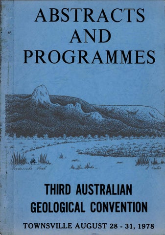
COVER ILLUSTRATION:
Pen-and-ink view southwest from Townsville showing the scarp of Hervey Range which is capped by a peneplain surface thought to be of mid-Tertiary age and to have been uplifted in the Pliocene, Frederick Peak, an eroded acid volcanic neck probably of Permian age, projects slightly above the peneplain surface and would have stood as an erosional remnant on the mid-Tertiary landscape. Original by E, Oates.
SUHMARY PROGRAnfiE
Morning sessions commence at 9.00 am, afternoon sessions at 2.00 pm. Tea breaks are at 10.30 - 11.00 im. and 3.30 - k,00 pm. Session times for Wednesday afternoon are an exception commencing at I.U5 and with no tea break. This is to allow an early departure to Magnetic Island, venue for the congress dinner.
Monday Morning General Session
Geology and geophysics of NE Australia
Central Lecture Theatre
Coal measure sediments find sedimentation The recognition of primary magmatic affiliations in altered rocks General tectonics (tectonic profiles, lineament analysis, macrostructures) Advances in the functional interpretation of fossil invertebrates Geological Conservation
Chemistry Room OOU Geology Room 101
Geology Room 101
Geology and geophysics of NE Australia
Central Lecture Theatre
Monday Afternoon Session 3 Session 9 Session 10 Session 13 Session 17
Geology Room 201 Geology Room 125
Tuesday Morning General Session Tuesday Afternoon Session 1 Session 6
Session 9 Session 10 Session 12
Ancient and modern carbonate deposits Styles of mineralisation in north eastern Australia - concepts and exploration strategies. The recognition of primary mafprialic affiliations in altered rocks General tectonics (tectonic profiles, lineament analysis, macrostructures) Past and present influence of benthos of substrate characteristics
Chemistry Room 005 (Geology Room 201 Geology Room 101 Chemistry OOU Geology Room 125
Wednesday Morning General Session
Geology and geophysics of NE Australia
Central Lecture Theatre
Wednesday Afternoon Note:
SessionU Session 8 Session 11 Session 15 3.50p.m.
Sessions begin at 1.45p.m.
General Session : Sedimentation ASG meeting Granites and tin mineralisation Biostratigraphic applicability of the international code Miscellaneous mineralogy-petrology Bus Departure to Congress Dinner Venue
Chemistry Room 00^+ Geology Room 201 Geology Room 125 Geology Room 101
Thursday Morning General Session
Geology and geophysics of NE Aui:tralia
Central Lecture Theatre
Modern d(.-velopments in coal geology Styles of miner ;jli sal ion in north eastern Australia - concepts and exploration strategies High pressure minerals and genesis of the basaltic magmas of eastern Australia Engineering Geology Quaternary studies (joint with Inst. Aust. Geog.)
Geology Room 101
Thursday Afternoon Session 5 Session 6 Session 7 Session ik Session l6
Geology Room 201 Chemistry Room OOh Chemistry Room 005 Humanities 1, Room 003
GENERAL SESSION GEOLOGY AND GEOPHYSICS OF N.E. AUSTRALIA CONVENOR
Venue
Central Lecture Theatre
Programme
:
:
P.J.
STEPHENSON
Time
every morning
Monday 9 . 0 0 - 9.30 9 . 3 0 - 10.00 10.00 - 10.30 11.00 - 11.30 11.30 - 12.00 12.00 - 1 2 . 3 0
R.A. Hendorson 'I.e. Dooley J . Mutter & C. Karner (J.M. Derrick, K. Pliimb & I . Wilson N. Williams I. Withnall, M.J. Rubenach & J . H . C . Bain
Cjeolo(;ical framework Geophyi:.ics : crustal structures Geophysics : the continental margin Precambrian geology : McArthur-Cloncurry region Mineralisation : McArthur-Cloncurry region Precambrian geology, Georgetown province.
'I'uesday 9.00 - 9.30
11.00 - 11.30
J . H . C . Bain & I . Withnall E.C. Druce I5c J . H . Shergold G.O. Arnold & J . F . P'awckner R.G. Taylor
11.30 - 12.00
D.H. Wyatt ii: J . S .
12.00 - 12.30
B. Oversby.
9 . 3 0 - 10.00 10.00 - 10.30
Mineralisation in the Georgetown province Cambricin-Qrdovician geology, Georgina Bas in Broken River-Hodgkinsori provinces
Jell
Mineralisalion, Broken Hiver-Hodgkinsoii provirjce Devonian-Carboniferout;, Townsville hinterland Late Palaeozoic vulcanism
Wednesday 9 . 0 0 - 9.30 9.30 - 10.00
D . N . G . Richards W.C. Lacy
10.00 - 1 0 . 3 0
H . R . E . Staines & W.H. Koppe J. Smart & B.R. Senior R. Evans T . H . Bell
11.00 - 11.30 11.30 - 12.00 12.00 - 12.30
Palaeozoic granitoids Mineralisation, New England fold belt extension North Bowen Basin Jurassic-Cretaceous basins Galilee and Northern Eromanga basins Deformational history
Thursday 9.00 - 9.30 9.30 - 10.00 10.00 - 10.30 1 1 . 0 0 - 11.30 11.30 - 1 2 . 0 0 12.00 - 12.30
K. Grimes P . J . Stephenson, F . L . Sutherland & T. Griffin R. Coventry, D. Hopley et G.R. Orme M. McEniery C. Murray
Cainozoic sediments Cainozoic vulcanism The Quaternary Barrier Reef - shelf sediments Underground water Summing up
THE BROKEN RIVER AND HODGKINSON PROVINCES by G.O. Arnold and J . F .
Fawckner
Systematic 1: 250 000 regional mapping of the Hodgkinson and Broken River Provinces was completed over a decade ago; the resulting geological framework has since been added to by many workers, but many significant problems remain.
The two p r o v i n c e s Siluro-Devonian
flysch,
comprise l a r g e
and a c i d v o l c a n i c s , Two r e c e n t provinces belt
contrasting tectonic
the P a l a e o z o i c
hypotheses
A c c o r d i n g to the
poorly
for
first
hypothesis,
fossiliferous,
The f l y s c h
and t e r r e s t r i a l
granites.
sediments
development o f
and deformed i n
arc
along what was p r e v i o u s l y
an e a r l y P a l a e o z o i c
The f l y s c h b e l t was d e f o r m e d , u p l i f t e d ,
and i n t r u d e d as i t
sited
became the s i t e o f a Permo-Carboniferous
magmatic
is sediments
the S i l u r o - D e v o n i a n
deposited
S i l u r o - D e v o n i a n magmatic continental margin.
deformed,
Precambrian t e r r a i n .
and Permian s h a l l o w marine
and i n t r u d e d by Permo-Carboniferous
have been p r o p o s e d .
represents
areas o f m u l t i p l y
l y i n g e a s t o f an e x t e n s i v e
unconformably o v e r l a i n by C a r b o n i f e r o u s
an arc-trench g a p ;
these flysch
to t h e i r west l a y
a
stable later
arc.
Accordirir; tin? second hypotlies 1:3, the S i l u r o - D e v o n i a n f l y s c h b e l t was formed i n a rriar(:;inaj baiiin dcivelopcd by r i f l i n g noar l.liu r^dgo o f n c o n t i n e n t a l marv.in. Sediments withJri the basin were derivc'd Crorti boLli e<'i:jL luid wai'^ly bascilt ic volcaii i rvm and a d i v e r s i t y of sedlrneiitai-y reciitries accotiipanl ed exp-uisioti o f the b a s i n . The b a s i n w.-u; deformed fmd upl i f t e d as continerit?jJ. margin Liubduction recomirienced and c o n t i n u e d throur^h the Late C a r b o n i f e r o u s and P e r m i a n . These c o n f l i c t i n g hypotheses r e f l e c t a number o f important u n r e s o l v e d problems i n the Hodgkinson and Broken R i v e r P r o v i n c e s : the s i g n i f i c a n c e and age o f a phase o f e a r l y q u a r t z o s e a r e n i t e d e p o s i t i o n , p a r t l y o f f l y s c h f a c i e s ; the r e l a t i o n s h i p o f the Barnard Metamorphics to S i l u r o - D e v o n i a n u n i t s to the w e s t ; the s i g n i f i c a n c e o f abundant m a f i c v o l c a n i c s throughout t h e S i l u r o - D e v o n i a n f l y s c h ; the age and e x t e n t o f p o s s i b l e contemporaneous a c i d magmatism both t o the west and e a s t o f t h e S i l u r o - D e v o n i a n f l y s c h b e l t ; the s i g n i f i c a n c e o f w i d e s p r e a d soft-sediment d e f o r m a t i o n i n the S i l u r o - D e v o n i a n f l y s c h ; and the age and i n t e r - r e l a t i o n s h i p o f r e g i o n a l f o l d i n g p h a s e s .
O K i O J I T S IT! 'm^'l GIX'RGK^O'VN li^-HION by J . r . C .
Bain
T.''.
Withnall
S i n c e r e v i e w s o f m i n e r a l d e p o s i t s i n the '^eorfretovTi r e g i o n were l a s t p u b l i s h e d s e v e r a l h i t h e r t o unknown types have been f o u n d : new infonriation permits a r e a p p r a i s a l some p r e v i o u s v i e w s on o r i g a n s and r e l a t i o n s h i p s o f many d e p o s i t s .
of
Many small b a s e metal d e p o s i t s and p r o s p e c t s i n the Einasleig"h Metamorphics and Robertson H i v e r F o r m a t i o n , p r e v i o u s l y thourht to have been i n t r o d u c e d by e i t h e r Precambrian d o l e r i t e or l a t e P a l a e o z o i c a c i d i g n e o u s i n t r u s i v e s , a r e p o s s i b l y deformed and metamorphosed s y n g e n e t i c s t r a t i f o r m b o d i e s • They have many g e o l o g i c a l p r o p e r t i e s i n common w i t h much l a r g e r m d better-knovm sliale-iiosted massive s u l p h i d e d e p o s i t s such as the Broken H i l l and Mt Ji^a. ore b o d i e s . Both ho:vt rock u n i t s are o l d e r tlian 1 S 7 0 m . y . and p o s s i b l y youn/-er than 1H00 m . y , i . e . a s i m i l a r a,,-e to lli t oC the Mount I s a C r o u p . An u n u s u a l dej-osit o f u r a n i u m , f l u o r i n e and molybdenum m i n e r a l s ( t h e Maureen p r o s p e c t ) iii sedimersts at tho b a s e o f a l a t e P a l a e o z o i c a c i d v o l c a n i c formation ^^ km n o r t h of Geor/^'etovm i s ])robably o f hydro thermal ori^^in and g e n e t i c a l l y r e l a t e d to u n e x p o s e d l a t e Palrieozoic -^ranite. Although few data a r e a v a i l a b l e , i t seems that t h i s d e p o s i t a n d a c ^ e a t many o t h e r uranium o c c u r r e n c e s i n the r e g i o n a r e g e n e t i c a l l y r e l a t e d to the l a t e P a l a e o z o i c a c i d i/^neous petroc'/raohic province that c o v e r s some 1 2 0 0 0 0 lan^ i n the C a i m s Townsville hinterland. D e p o s i t s a r e mostly l o c a l i s e d n e a r the l a t e P a l a e o z o i c s u r f a c e i n zones that had hifj;h p o r o s i t y and p e r m e a b i l i t y a,no were l i n k e d w i t h source r e g i o n s by permeable channelv/ays (commonly f a . u l t s ) . Suit-ibly porous and permeable a c c e s s c h a n n e l s and d e p o s i t i o n s i t e s may be o f s e d i m e n t a r y , d i a . g e n e t i c , v o l c a n i c , hydro thermal or t e c t o n i c origin; c o n s e q u e n t l y d e p o s i t s , a l t h o u g h g e n e r a l l y s m a l l , are p r e s e n t throu.^.hout the r e g i o n i n ? v=i''iety oi' lio'-t r o o k s . A v e r y low .frnd^ porphyry Cu-r^^o d e p o r t t 14 km wen o f Georgetown (Nouiit T u r n e r p r o s p e c t ) c o n s i s t s o f (iisseminatod an(i inicroveinlet p y r i t e , m o l y b d e n i t f nnd c h a l c o p y r i t e a s s o c i a t e d v/ith exten:~'ivo prir overlappin.'. zones of p e r v a s i v e and f r a c t u r e c o n t r o l l e d hydrothermal a l t e r ' t i r > n , numerous i n t r u s i v e and collftpse b r e c c i a s , p o r p h y r i t i c r h y o l i t e stocks and dyke sw.irins and reveral :7mall ];odies of porrViyritic micros.xnnodiorite a l l most p r o b a b l y o f l a t e P^^laenzoic Much o f the tiost rock i s I r o t e r o z o i c ^ T a n i t e . The ? h y l l i s May d o p o n ' t ( l ' ki.i to ti,e w e s t ) and ^notVl,'^r n e a r Cardross in the Darr,along I n l i o r pre s i m i l a r . M c h der>osits and r e l a t e d types l i k e the K i d s t o n b r e c c i a pipe Au-deposit a r e p r o b a b l y not as c^carce i n tliir. ro^:lon as has p r e v i o u s l y been assumed, but a,re u n l i k e l y to have s u b s t a n t i a l nuper';enp enrichment z o n e s .
THE DEFORmTION HISTORY OF NORTHEASTERN QUEENSLAND - A NEW FRAMEWORK by T.H. Bell
Six deformations ranging from Pre-Cambrian to Mesozoic in age have been delineated, correlated, and dated across the whole of northeastern Queensland with the exception of the coast around Cairns and Innisfail. A major fold, the Big Bend Mega Fold has been delineated, and dated at 310-315 my. The effect of this fold on our understanding of the Geology of northeastern Queensland is described and discussed.
THI-. QUATERNARY OF NORTHEASTERN AUSTRALIA By R.J. Coventry, I), llopley, J. Caniphell, I. Douglas, N. Harvey, A.P. Kershaw, J. Oliver C.V.C. Phipps, and K. Pyc Quaternary deposits of northeastern Australia are widespread but poorly understood. It is clear from many areas that processes of erosion, deposition and weathering in the tertiary have continued without a break into the Quaternary. In contrasting and fluctuating environments elevated landscapes have been subjected to episodic denudation producing alluvial, colluvial, aeolian, lacustrine and coastal deposits. These, often derived from deeply weathered landscapes, have themselves been subjected to tropical weathering. In some sequences Quaternary basalts are incorporated and offer the opportunity for absolute dating. The largest Quaternary province is the Great Barrier Reef where strata overlying its mid-tertiary foundations may also provide opportunity for construction of a more complete Quaternary stratigraphy. Only from the last 125,000 years, however, are detailed events known. Reconstruction of climatic and vegetational histories based largely on palynological and eustatic sea level studies is also limited to the same period. They suggest that cooler, drier conditions existed throughout most of the last glacial cycle. Such environmental conditions should have prevailed during the migration of aboriginal man to Australia more than 40,000 years ago. His presence in the northeastern region is currently documented only for the past 13,000 years.
A REVIEW OF CRUSTAL STRUCTURE IN NORTH-EAST AUSTRALIA by
J.C. Dooley
Geophysical evidence relating to the crustal structure of Northern Queensland includes gravity reconnaissance coverage, partial aeromagnetic coverage, deep seismic sounding by refraction and reflection methods, and heat flow measurements at a few sites. Prominent features of the gra.vity field include the continental edge effect, and the effect of the very broad gradient shown by satellite orbit analysis as associated with a high anomaly north of PNG. After removing these, the gravity evidence suggests that the various features in the area are close to isostatic equilibriiom. Seismic refraction surveys include the CRUMP survey of 1966 in the Cape York Peninsula, showing a two layer crust (apart from sediments) with thickness ranging from 25 km near the coast to km under the Great Dividing Range; a single ended profile in the Galilee Basin giving a three-layer crust with thickness k2 km; and a reversed profile in the Bowen Basin giving a three-layer crust with average thickness of 35 km. There are differences in depths interpreted to the intermediate layers, and the differences between Moho depths from adjacent surveys are not consistent with the gravity field; possible causes of these discrepancies are examined. 3MR seismic exploration parties have recorded seismic events at a few sites in the area at times out to 12 or 13 s; these have been interpreted as reflections from the Moho and intermediate layers, giving crustal thickness ranging from 30 to 39 km.
ECONOMIC GEOLOGY OF THE GALILEE BASIN by P.R. Evans
^^^ Galilee Basin, an intracratonic depression which formed during Late Carboniferous to Middle Triassic time and filled with up to 3000 m of n o n - L r S e sediments lon^ between latitudes 20^3 and 26oS and longUudL I^'e' S o s e ^ the re^r.^ Queensland Only the eastern and northern margins of the basin are exposed, the rest is concealed below the Late Mesozoic Eromanga Basin. The reflections at Laglan and Comet are difficult to correlate with the refracting layers of the Galilee and Bowen Basin refraction profiles. Normal aeromagnetic surveys give patchy coverage of the area, but deep crustal information i r, difficult to extract from thern. i^MR has flown a series of long traverses at a height oV 3 km Lo study the longer wave-lengths, and the correlation of these with gravity anomalies and major geological features will be examined. Some trends and boundaries correlate well, but other major features have no expression in the gravity or the magnetic field. Heat flow measurements show higher heat flow in the west of the state than in the east; this may be partly associated with the re-charge areas at the east of the Great Artesian Basin. Possible models for the transition from continental to oceanic crust are s^gested.
MINERALISATION ASSOCIATED WITH THE HODGKINSON-BROKEN RIVER PROVINCES by P. W. Gregory, R. G. Taylor & A. H. White The major metallogenic provinces within the region are the mutually exclusive Sn-W and Au-Sb regions, together with a small Cu-rich area around Chillagoe. Recent exploration has defined a fluorite-rich subprovince within the Herberton tinfield and a new W-rich region around Mareeba. The tin provinces can be subdivided into two types, the plutonic (Cooktown) and the subvolcanic (Herberton, Kangaroo Hills) settings each with a characteristic style of mineralisation. Several new types of tin deposit have recently been recognised including albite-rich, amphibole-rich and fluorite-magnetite styles. Recent research has also defined a diffusely distributed series of volcanogenic deposits. These occur in association with spilitic basalts, and show many similarities with the Japanese Kieslager-Besshi deposits and the cuprous pyrite deposits of Cyprus. Three main cycles of geological activity can be recognised, together with several subsidiary cycles. Each cycle comprised an initial active phase with upwarp, erosion and deposition followed by a stable phase in which planation surfaces are common and deep weathering the main process. In late Cretaceous time much of the Inland Region of the state was a planation surface and deep weathering occurred there, in the southwestern Papuan Basin, and possibly in the Karumba Basin. In the east, however, an active phase had been initiated by the opening of the Tasman and Coral Seas. Uplift occurred, with some volcanism in the southeast, and erosion and deposition continued into the Eocene. Terrestrial deposits formed in the Karumba and Capricorn Basins, and in a number of smaller areas in the southeast. The fluvial Glendower Formation spread south-westwards across the Inland Region. Eocene marine deposition occurred in the Papuan Basin and on the Queensland Plateau. Activity died down and the late Eocene and early Oligocene was a time of stability and deep weathering in many areas. In the Oligocene the second cycle of activity commenced with the uplift of the eastern regions and there was extensive volcanic activity in the Fitzroy and southern Burdekin Regions. This volcanism consisted mainly of basaltic flows and continued into the early Miocene. The main areas of continental deposition were in the Duaringa Basin (Oligocene to early Miocene), and the down faulted Hillsborough Basin (Oligocene). A mixed
marine aiid continental facies formed in the late Oligocene Capricorn Basin. Miocene marine deposits formed in the Capricorn Basin, on the Queensland Plateau and in the southwestern Papuan Basin. Onshore, activity generally died dovn in the latter part of the Miocene and an extensive lateritised surface formed in the eastern regions. An exception is the Karumba Basin where deposition of the Wyaaba Beds may have commenced in late Miocene time: it continued into the early Pliocene before stability and deep weathering occurred. In the eastern regions the third cycle of activity commenced with Pliocene upwarping which continued in several stages during the Pleistocene. Basaltic flows occurred in a number of provinces extending from Hughenden to Cooktown, with minor activity further to the north and south. Sediments are interbedded with the volcanics and a sequence of up to five fluvial terraces or fans indicates an alteration of geological activity and stability during the late Pliocene and Quaternary. The major period of stability was in the latest' Pliocene when a ferruginised surface formed in the Burdekin Region.
THE CAINOZOIC GEOLOGY OF NORTH QUEENSLAi\fD by K.G. Grimes
The tectonic evolution of north Queensland can be largely related to the opening of the Tasman Sea and the separation of the Australian and Antarctic plates in the late Cretaceous to early Tertiary, and the subsequent northern drift of the Australian plate and its interaction with the Pacific plate. During this period Queensland suffered mild, sporadic, epeirogenic cratonic movements. The most pronounced movements were along the eastern margin; the inland regions suffered only mild warping. The basin has no current economic value, but is thought to have potential as a source of petroleum and coal. Three subdivisions of the Galilee Basin are recognised; to the west the Lovelle Trough; to the east a northern segment, which includes the Koburra Trough and which is separated from a southern segment by the Maneroo Platform. Basement varies from Precambrian to Devonian in age. Basin fill is divisible into three depositional sequences, each separated from the others by regional unconformities. The oldest and thickest sequence consists of Late Carboniferous to Early Permian alluvial sediments, some of which have a glacial origin. Minor coal bearing sediments occur towards the top of the sequence. The second unit consists of coal bearing alluvial sediments of Late Permian age. The third sequence, a complex of Early to Middle Triassic alluvial clastics, is dominantly sandy in character. Maturation studies favour the top of the Lower Permian as source for petroleum. However, adequate analyses of structural form, style and timing in relation to petroleum generation, migration and entrapment have yet to be made before the basin's petroleum potential may be adequately estimated or realised. Sub-bituminous, low sulphur coal seajns of the Late Permian sequence and of potential economic quality have been identified in the southeastern part of the basin. However, water-bearing overburden may limit, if not preclude its extraction by open cut mining methods.
GEOLOGICAL OUTLINE AND TECTONIC HISTORY OF NORTHEASTERN AUSTRALIA
by R.A. Henderson
The geology of U.K. AustraJ.ia is best outlined in term:; of descriptive units, here termed provinces, tor which /genetic and interpretative connotation is minimised. Those primarily of sedimentary character are: Mt. Isa-Cloncurry, Georgetown and Yambo-Coen Provinces (deformed, granite intruded Carpentarian terrains); McArthur Province (CarpentarianAdelaidian platform terrain); Ravenswood-Lolworth and Anakie-Drummond Provinces (deformed, granite intruded Proterozoic terrains with folded Palaeozoic cover); Arafura and Georgina Provinces (Lower Palaeozoic platform terrains); Hodgkinson and Broken River Provinces
(deformed Lower Palaeozoic-Carboniferous terrains; Bowen and Galilee Provinces (little disturbed Carboniferous-Triassic terrains; Craigilee-Yarrol Province (deformed Upper Siluriaji Carboniferous terrain); Great Artesian Province (Jurassic-Cretaceous terrains underlain by Palaeozoic and PreCambrian basement) and the Hillsborough-Capricorn Province Uittle disturbed Cretaceous-Tertiary terrain). In addition, two provinces of igneous character are conveniently recognised; Coastal Ranges Igneous Province (Upper Devonian-Cretaceous acid-intermediate plutonics; volcanics and volcaniclastics) and N.E. Queensland Basalt Province (Neogene flood basalts), New stratigraphic evidence suggests that metamorphics of the Ravenswood-Lolworth Province include PreCambian basement which may also be inferred for the Anakie-Drummond Province where similar geology prevails. The cratonic margin, taken as the eastern limit of PreCainbrian basement, is thought to be close to the margins of the Yambo-Coen, Georgetown, Ravenswood-Lolworth and Anakie-Drummond Provinces. Data currently available suggest the craton to be largely of Carpentarian age. Platform cover is extensively developed across it with important epeiric sedimentary episodes having occurred in the Adelaidean, Cajnbrian, Devonian-Carboniferous, Permian-Triassic and Jurassic-Cretaceous. Near the cratonic margin, thick, folded Upper Palaeozoic sequences, which include'a substantial volcanic and volcaniclastic complement, predominate. A zone of complex geology lies to the east of the craton and is thought to have resulted from active continental accretion at a consuming plate margin. Two discrete accretionary episodes, separated by an unconformity which dies out towards the craton, are apparent. One is represented by deformed flysch of the Broken River and Hodgkinson Provinces, deformed acid-intermediate volcaniclastics and flysch of the Craigilee-Yarrol Province, and perhaps by granites intrusive into the cratonic margin. It is dated as late Silurian-middle Devonian. The other is of Carboniferous-Permian age and is represented by voluminous acid-intermediate volcanics, volcaniclastics, and plutonics which are grouped in the Coastal Ranges Igneous Provinces and by deformed flysch represented in the Craigilee-Yarrol Province.
MINERALISATION IN THE EXTENSION OF THE NEW ENGLAND AND LACHLAN FOLD BELTS INTO NORTH QUEENSLAND
by W. C. Lacy
^ e New^gland and Lachlan Fold Belts of the Tasman Orogenic Zone extend northward from New South Wales into south-eastern and central-eastern Queensland. I^ey contain conchromim"''' ° copper-molybdenum, tin-tungsten, lead-zinc-silver, gold, and nickel-cobalt-
Deposits formed in both submarine and subaerial environments during pre-, syn- and postorogenic periods. They include: pre-orogenic, submarine volcanogenic stratiform deposit; ^n-orogenic, submarine serpentinite deposits derived from oceanic crust; and post-orogenic Benioff Zone derived subaerial or 'still born' calc-alkaline intrusive related porphyry copper-molybdenum, contact metasomatic, vein deposits, and submarine copper-bearing anLsite flows; and crustal derived granitoid related tin-tungsten vein and stockwork deposits. There are four major periods of post-orogenic mineralisation (Siluro-Devonian, PermoCarboniferous, Permo-Triassic, and Early Cretaceous) associated with calc-alkaline intrusives that invade a series of island arcs and intra-arc basins along distinct transgressive linear belts concentrated at intersections and flanks of highs, and less distinctively aligned deposits in crustal derived granitoids. Each intrusive phase superimposes, and post-dates by ^proximately 100 million years, more diffusely distributed volcanogenic stratiform deposits. They are contemporaneous with deposits of copper in submarine andesite flows (which may represent vented porphyry coppers), contact metasomatic deposits (where carbonates are present in the sediments), and widespread vein occurrences. Syn-tectonic serpentinite slices of oceanic crust with associated mineralisation redistributed by leach solutions follow zones of major thrusting. Character of the deposits reflects the structural and chemical environment of formation and depth of erosion.
GROUND WATER RESOURCES OF NORTH-EAST AUSTRALIA by M. McEniery
The groundwater resources of North Queensland are presented in broad outline. The region is defined as north of the Tropic of Capricorn. Where possible the magnitude of resources are indicated together with an index of the reliability of the assessment. The overall relationship between geology and hydrology is expressed via the usual porosity classification describing the dominant mode for storage and transmission of groundwater, i.e. rocks are divided into porous or fractured classes. The porous class is further subdivided into unconsolidated and consolidated rocks. Throughout the paper they are referred to simply as "unconsolidated", "porous" or "fractured" as the case may be. The unconsolidated and fractured categories are dealt with in drainage division and drainage basin order commencing with the North East Coast division and proceeding in order to Lake Eyre and Gulf divisions. Porous rocks in the region are dominant only in the Great Artesian Basin, which is discussed in terms of its main structural components the Eromaga and Carpentaria Basins. The carbonate rocks at the western extremity of the region are treated separately. Brief details are given for each area of depth, water level, water quality, annual yields, bore yields, hydraulic characteristics etc. General statistical and groundwater use are presented.
THE CONTINENTAL MARGIN OFF NORTHEAST AUSTRALIA by J.C. Mutter and G.D. Karner
Studies of the continental margin (excluding the Great Barrier Reef Shelf) using the techniques of marine geophysical research began in the mid 1960s, and have progressed fairly steadily through the 19TOs. The early stages of this type of work were carried out by vessels from overseas institutes which collected gravity, magnetic, bathymetric, seismic reflection and refraction data, as well as taking sea bottom samples and heat-flow measurements. In the early 1970s the Australian Government's Bureau of Mineral Resources made a systematic geophysical reconnaissance of the margin. Three sites have been drilled by the Glomar Challenger for the Deep Sea Drilling Project. Taken together these data provide a reasonable basis upon which a structural and stratigraphic analysis of the margin can be made. The structural fabric of the continental margin consists of the submerged and dissected offshore extension of the Tasman Geosyncline. An unusually wide margin, with continental crust underlying a series of marginal plateaus, stretches from the Gulf of Papua in the north to the southern end of the Great Barrier Reef in the south. The plateaus are bordered on the east by the Coral Sea Basin and Cato Trough, and there is some evidence to suggest that continental fragments lie east of these ocean basins. The marginal plateaus all support reef growth, and on the largest of them, the Queensland Plateau, it is particularly lavish. The area occupied by the continental crust of the margin is approximately equal to half that of the State of Queensland. The area now occupied by both the margin and Coral Sea Basin was probably an integral part of the Tasman Geosyncline until the late Mesozoic. The margin as it is recognised today formed in two main stages: 1. During the late Mesozoic a period of taphrogenesis created a complex of rift graben which lie beneath the margin's trough system, and on the outer part of the Marion Plateau. Orogenesis altered the deep crustal structure in these regions, causing subsidence and providing depressions for sediment accumulation. 2. In late Cretaceous and early Tertiary sea-floor spreading created the Coral Sea Basin and Cato Trough, splitting off parts of the continental lithosphere. Following cessation of spreading, subsidence promoted by thermal contraction of the lithosphere affected all areas around these ocean basins. Reef growth was established on the plateaus as subsidence commenced, and survives today on basement highs.
Mthough the basic elements of the margin's history are fairly veil understood, some important questions remain unanswered. A programme of future work is suggested with the object of solving these problems.
SEDIMENTS AND SEDIMENTATION IN THE GREAT BARRIER REEF PROVINCE AND ADJACENT BAYS AND ESTUARIES by G.R. Orme and P.G. Flood
The bathymetric and sedimentary characteristics of the Great Barrier Reef Province have been strongly influenced by the Pleistocene emergences and early post Pleistocene events, and the occurrence of relict features is considered to be widespread. The separation of two distinct sedimentation regimes, namely, the reef-tops and the interreef is favoured by the considerable bathymetric range characteristic of this province. On a regional scale broad f a d e s trends based on the ratio of carbonate to non-carbonate and mud to sand can be recognised, which impart an approximate meridianal zonation to the shelf sediments. This distribution reflects two salient source factors, the eastern reefal carbonate areas of the outer-shelf, and the western, mainland provenance of terrigenous sands and muds. Detailed investigation of the sediments in specific areas have revealed complexities which reflect a variety of factors. The carbonate component of the shelf (interreef) sediments is provided by foraminiferans and molluscs (the most abundant grain types), and by coralline algae, corals and Halimeda which are reef controlled. Quartz distribution occurs mainly on the inner-shelf related to major stream systems, and may occur near continental islands. Terrigenous mud is dominant in the axial shelf zone and also in the near shore zone in part of the central region. Relict sands and gravels may be important locally. Mixing of end-members appears to be an important process in determining the nature of most interreef sediments, while others may represent lag deposits, dependent for their grain size characteristics upon in situ post mortem contributions and 'currents of removal*. Studies of sediment distributions in terms of texture and grain type have been carried out in the vicinity of the Howick Group, Lizard Island, the Arlington Reef Complex, Princess Charlotte Bay, the Whitsunday Passage, and in an area extending from Gladstone Harbour across to the Capricorn Channel. Sediment dispersal is believed to be restricted. The reef-top provides a considerable contrast. It is the area of most active change; under the influence of breaking and translatory waves, and tidal currents, erosion and sedimentation compete with reef growth, influencing ecological zonations which in turn affect sedimentation. A complete spectrum of grain sizes is produced at the windward reef edge. Boulder and gravel deposits form as lag deposits while fine debris is carried to leeward. Recent investigations have shown that 95% of the variation in the sand veneer can be explained in terms of three skeletal component groups (coral + coralline algae, Halimeda, and benthonic foraminiferans) and three grain size populations which represent traction saltation, and suspension populations. Thus grain size distribution of the bioclastic sediment is indicative of the hydrodynamic processes acting within the depositional environment. There is also a constant relationship between the reef type and the modal size. At Lady Musgrave Reef a horizontal zonation in terms of mineralogy and geochemistry has been demonstrated. The usefulness of statistical grain size parameters has been tested on reef-top and interreef sediments, and on sediments from Broad Sound and Gladstone Harbour. While in the pure carbonate sediment of the reef-top there is a relationship between modal diameter of carbonate sands and the environment, sorting, skewness and kurtosis values do not display a consistent association with individual depositional environments, neither are they of any value in classifying interreef sediments. Studies of grain size and grain type distributions in some areas have shown that it is possible to deduce sediment dispersal mechanisms. Other studies of sedimentation have been concerned with the physical factors involved in sediment transport (currents, tides, waves), or the identification of sediment sources and dispersal in relation to distributive provinces, involving the measurement of sediment being transported in nearshore systems.
10
LATE PALAEOZOIC CONTINENTAL VOLCANISM IN NORTH-EASTERN QUEENSLAND by B.S. Oversby, L.P. Black, and J.W. Sheraton
During Carboniferous and Permian time a continental volcanic field covered much of north-eastem Queensland. The field, centred in the Townsville-Georgetovn-Chillagoe district, was characterized by voluminous ignimbrite eruptions and development of ring dyke "complexes". The field was investigated cursorily until the late 1950's and early 60's, when Colin Branch studied it comprehensively, and laid the foundations for subsequent work. The significance of Branch's research lay in its demonstration of the importance of ignimbrites, and introduction of the concept of cauldron subsidence (defined as a subsurface phenomenon for the purpose of this review). Current research is extending Branch's pioneering work, and leading towards better understanding of the nature, evolution, and mineral potential of the field. Branch established stratigraphic units, which have become entrenched; sparse, locally conflicting, palaeontological and isotopic data provided age control. The volcanic units are convenient, although artificial in that their definitions were based, in part, on recognition of three supposed episodes of eruption, and on the belief that sequences in different synvolcanic "cauldron subsidence areas" were essentially unconnected. Some of Branch's "cauldron subsidence areas" are bounded by postvolcanic, or apparently imaginary, structures, and probably had no direct influence on volcanism at all. Current stratigraphic studies, supported by controlled isotopic dating and preliminary geophysical data, are revealing local complexities which reflect the interplay of evolving volcanic and subvolcanic features in the field. Comparisons can be made with ignimbrite-dominated provinces characterized by collapse calderas, as well as with regions containing classic cauldron subsidence structures. TTie late Palaeozoic volcanic and subvolcanic rocks of north-eastem Queensland are of calc-alkaline composition; most contain more than 70% silica. They are chemically similar to, but less fractionated than, the Elizabeth Creek Granite and similar rocks described in a companion paper. Most dacites and rhyolites had a parent magma which was probably generated by melting of rubidium-poor, relatively dry, lower continental crust. Basalts and andesites, which are of localised occurrence, crystallised from a second magma type which may have been derived from subducted oceanic lithosphere. Magma ascent was evidently controlled by local structures; the Palmerville and Millaroo fault zones apparently exerted a major influence. The tectonic environment of the field was postorogenic (or "transitional"), and at least superficially "Andean". Known mineralisation which can be linked with late Palaeozoic volcanism is presently of no economic significance in north-eastern Queensland. Postvolcanic deposits, notably of tin and uranium, hosted by volcanic and subvolcanic rocks and structures, are more important. Aspects of mineralisation are discussed more fully in companion papers.
THE PREGAMBRIAN GEOLOGY OP THE McARTHUR RIVER-MOUNT ISA REGION, NORTHERN AUSTRALIA by K.A. Plumb, G.M. Derrick and I.H. Wilson
The Carpentarian McArthur Basin, Lawn Hill Platform, and Mount Isa Orogen are situated on and adjacent to the eastern edge of the North Australian Craton. All overlie a continental basement of Lower Proterozoic rocks of the North Australian Orogenic Province. The McArthur Basin is the principal element of the North Australian Platform Cover. The Lawn Hill Platform, also part of the Platform Cover, is gradational into the Mount Isa Orogen, a marginal orogenic belt in which generally thicker successions have been more intensely folded, faulted, metamorphosed, and intruded by granite than the adjacent platform areas. The Lower Proterozoic basement (exposed in the Kalkadoon-Leichhardt Block) has been incorporated into the orogen during re-working of the craton margin. Relationships with the Georgetown and Coen Inliers, farther to the east, are concealed by younger covers. Very similar sedimentary successions accumulated contemporaneously in both the platform covers and the orogen. Both overlie pre-1780 m.y. old acid volcanic and granitic basement. Sandstone-volcanic sequences, with minor carbonates (Tawallah Group and equivalents), are overlain unconformably by dominantly carbonate sequences (McArthur Group and equivalents). Following final deformation of the Mount Isa Orogen sandstone-siltstone sequences (Roper Group and equivalents) covered much of the area with regional unconformity. Preliminary
11
data from current isotopic dating programs, still incomplete, are indicating that the total time range of development of the whole province is shorter than previously thought; perhaps in the total span of 1780 to 1500 m.y. The McArthur Basin is dominated by the fault-bounded Batten Trough, in which up to 12 km of sediments accumulated, with thinner sequences on stable shelves on either side. Differential subsidence of the trough was initiated at different times in different places* The trough has since been uplifted in the Batten Fault Zone. "Tawallah Group" volcanic rocks are, surprisingly, more abundant on the shelves than in the trough, where major syndepositional faults were active. Recent stratigraphic work has revealed extensive evaporitic, sabkha, and intertidal-supratidal carbonate complexes in the McArthur Group, with deposition of strata-bound lead-zinc mineralization in local depressions. Analogies may be drawn with modem environments, such as the Persian Gulf. The Nount Isa Orogen evolved from its pre-1780 m.y. continental basement, through an 18 km thick volcanic-sandstone rift basin and transgressive shallow platform sandstonecarbonate stage about 1780 to 1700 m.y. old (Tawallah Group equivalents), to partly intracontinental trough and basin stages containing stratiform lead-zinc mineralization in carbonate-siltstone-shale complexes (McArthur Group equivalents). Depocentres of these later intracontinental stages migrated cratonwards as the foreland to the east underwent uplift and tectonism. Basalts of the rifting stage are tholeiitic; volcanics and granite which terminate the transgressive platform sedimentation are mainly alkaline and peralkaline types, and together with gabbro and abundant dolerite dyke swarms may form a bimodal igneous suite typical of extensional crustal regimes. Up to four periods of low pressure amphibolite facies metamorphism are recognized in different areas, some of which predate associated granite intrusions. Folding, thrusting, and post-granite conjugate faulting appear to be due to craton-directed compression. The evolution of the orogen may be compared with other continental margin terrains, such as the Coronation Geosyncline and Appalachian belt of North America.
THE PALAEOZOIC GRANITOIDS OF NORTHEASTERN AUSTRALIA by D.N.G. Richards
Palaeozoic granitoids outcrop over some 34,000 km^ in northeastern Australia. They fall into two major age groupings - Silurian/Devonian and Permo-Carboniferous. Those believed to be Silurian/Devonian belong to four major batholiths or groups of batholiths - Ravenswood, Lolworth and Cape York Peninsula (C.Y.P.) Batholiths and the East Georgetown Province batholiths. These are restricted to the Precambrian basement, generally in the east of the area under review. There are problems involved in interpreting their ages and some may be Precambrian, but accepting the data on face value the Ravenswood Batholith is Early Silurian, the rest are Middle-Late Devonian. The Ravenswood Batholith consists predominantly of hornblende-biotite granodiorite and tonalite with subordinate phases ranging from gabbro to leucogranite. The Lolworth Batholith consists predominantly of (muscovite)-biotite adamellite and granodiorite. Granitoids of the east Georgetown Province seem to belong to a coherent group. They range in composition from biotite granite to hornblende-biotite tonalite. Chemically they are characterised by relatively low K 0 and Rb and high CaO, Na20, A l 0^ and Sr contents. The Robin Hood granodiorite to the west and diorites of the Diao batholith to the east are more typically calc-alkaline but retain the high Sr contents. The C.Y.P. Batholith consists predominatly of muscovite granites and adamellites with a range of modal and chemical compositions. Hornblende bearing rocks are subordinate. The Permo-Carboniferous granitoids fall into several distinct groups - a southern group embracing the Urannah Batholith and parts of the Ravenswood Batholith, a Townsville Chillagoe group (T-C), a Cairns-Cooktown group and a northern group embracing parts of the C.Y.P Batholith and Torres Strait. The southern group is largely undifferentiated. Rocks present range in composition from gabbro to leucogranite, though granodiorite is the most common. The T-C group is made up of several N-W trending batholiths and associated volcanic rocks. Most of the granitoids fall into a coherent mineralogical/chemical series which ranges in composition from hornblende-
12
biotite qranodiorito to hiotite leucocjranite. A second, more restricted series embraces more basic rocks. Some rocks fall into neither series. Rockg^of ^ t h series are characterised by relatively high Rb contents, high initial Sr /Sr ratios, low oxidation ratios and the presence of Sn mineralisation. The Cairns-Cooktown granitoids generally form small, meridionally orientated ellipsoidal batholiths. Their composition is usually in the range muscovite granitebiotite granodiorite. These generally have a restricted SiO^ range, high CaO and ^e 0 contents. The northern group is made up of rocks ranging from hornblende, adamellite to leucogranite. In terms of the I and S-type classification, the Lolworth and C.Y.P. Batholiths and Cairns-Cooktown group are considered to consist predominantly of S-type granitoids; the remainder are I-type granitoids. The distribution of I and S granitoids of different ages in eastern Australia is generally consistent with the formation of two "I-S Lines" during the Palaeozoic, one made up of Cambrian-Late Devonian granitoids, the other made up of Late Carboniferous-Triassic granitoids. The granitoids of northeastern Australia, however, do not appear to bear a simple relationship to this scheme.
UlTER PROTEROZOIC AND LOWER PALAEOZOIC ROCKS OF T m GEORGINA BASIN
by J.H, Shergold and E.G. Druce
The Georgina Basin, as described herein, embraces Upper Proterozoic and Lower Palaeozoic strata, commencing with Vendian glaciogene sediments and concluding with possible Mid Ordovician arenites. These rocks are divided into three tectonostratigraphic units, tectotopes, which are separated by major unconformities or disconformities. Tectotope 1, which includes glaciogene, terrigenous clastic and siliciclastic sediments passing upwards into carbonates spans the Proterozoic (Vendian) to Early Cambrian (Atdabanian or early Lenan). Tectotope 2 commences with a northern volcanic episode in the later part of the Early Cambrian or early Middle Cambrian, and comprises predominantly carbonate sediment deposited throughout the Middle and Late Cambrian, and diiring the earliest Ordovician. Tectotope 3 commences with unconformity or disconformity during the Early Arenig, and represents a dominantly siliciclastic phase of sedimentation whose record terminates within the Mid Ordovician. The differing spatial and temporal distribution of rock units within these tectotopes is described, and palaeogeographic interpretations are briefly discussed in biochronological and palaeomagnetic contexts.
JURASSIC-CRETACEOUS BASINS OF NORTH QUEENSLAND by J. Smart and B.R. Senior
In north Queensland Jurassic-Cretaceous rocks were deposited in the Carpentaria, Laura and Eromanga intracratonic basins, to a maximum thickness of more than one kilometre and underlying an area of about TOO 000 km^. Deposition began in the early Jurassic and mainly fluviatile sand was deposited until the end of that period, except in the NE, where paralic conditions become established in the middle Jurassic. The Cretaceous transgression came from the north; initially a thin sequence of paralic sand was deposited but a shallow sea was soon established and mud was deposited over the whole region. After the maximum extent of the sea in Late Aptian times, there was a slow regression which led to the deposition of a thick paralic sandy sequence in the Late Albian. Deposition in the Carpentaria and Laura Basins ended in the Late Albian or earliest Cenomanian, but in the Eromanga, continental deposition continued through much of the Cenomanian. Structurally, the basins are simple; they have not been subjected to compressional folding. All structures are the product of block faulting or draping over basement blocks, maximum throws are of the order of a few hundred metres but many are expressed only as monoclinal flexures in the Mesozoic rocks.
13
The only currently exploited resource of the basins is groundwater, drawn from the Jurassic and earliest Cretaceous sandstone units. There are large amounts of Cretaceous oil shale in the south which have potential for the future and some possibilities of other mineral resources such as coal and uranium.
THF. (rPJOLOGY OP THK NORTH BOWETJ BASIN by H.R.E. Staines &
Koppe
The north Bowen Basin is part of a structural remnant of a site of major Penno-Triassic sedimentation. The eastern margin of the basin was tectcnically active during the Permian, in contrast to the western margin which had been cratonized by the end of the Carboniferous. The eastern tectonically active part of the basin contains a erreat thickness of volcanics and relatively immature and deformed sediments, while the western seouence is relatively thin and undeformed, and includes a substantial proportion of mature'quartzose sandstone. Sedimentation was controlled primarily by the relationships between source area uplift and deDositional site subsidence, and by climate. The fossil and rock record indicates a moist, cold to cool temperate climate during the I'ermiari, while the Triassio climate may have been a little varmer with restricted or seasonal rainfaJl. Initial coal formation in the north and west of the basin early in the Perminn was followed by a m.i.1or marine t r a n s ^ e s s i o n . L.ubsequent ^ a d u a ] southward re^'^ression in the Late Permia,n led to the major period of coal formation. Economic do. '- 'Vn occr.r ir ^our strati ^^x^nhic ^^oupinrs. Coal rank increases eastwards from sub-bituminous )<0. s] to anthr'>cite fR . (may ) > > ^ . Vitrinite content ranges from to 80%. The major pi-oaucing mines in the reviewed area extract coking coal for export from seams of the Moranbah Coal Measures. Measured and indicated reserves in situ north of the Central Railway currently amount to 9775 million tonnes of coking coal and 4171 million tonnes of non-coking coal. Igneous intrusions have caused partial loss of coal in the northern part of the basin.
CAINOZOIC VOLCANISM IN NORTH EASTERN AUSTRALIA by P.J. Stephenson, T.J. Griffin & F.L. Sutherland
Cainozoic volcanic rocks extend south from Torres Strait in a discontinuous belt roughly parallel to the coast. Aside from isolated volcanism the geographic distribution patterns have been referred to 12 provinces north of 22^3, The total area preserved is approximately 23,000 km^ and the total volume of the order of 1^00 km^. Most of the provinces are basaltic. Only the Hillsborough and parts of the Nebo province show significant felsic volcanism in addition to basalts, except for McBride where one of l6k volcanoes developed phonolite. Ages range from latest Palaeocene ( >53.5 my) to Recent. The southern province, Nebo, contains the oldest recognised activity. Nebo, Hillsborough and Mingela include important Oligocene volcanism, with significant episodes. By contrast, all the provinces west and north of Charters Towers are characteri ed by much younger activity, with the oldest mezas in the McBride, Chudleigh and Sturgeon, dated in McBride as late Miocene (8 my). The bulk of these northern provinces are less than 5 my and extend into the later Pleistocene. Recent volcanism (to 13,000 y) is restricted to Atherton, McBride and Nulla. Patterns of known ages so far indicate spasmodic volcanism without distinct episodes since 5 my. Tlie provinces near Cooktown probably span a similar range, but the Torres Strait province is regarded as Pleistocene. Somewhat fewer than kOQ volcanic foci are known. Their distribution mostly confirms more restricted areas within the recognised provinces except for a single broad vent province in the Chudl.eigh-Sturgeon-Nulla region. Focal alignments are north-east and north-^est. Structural circumstances for localisation of the vent provinces are not easy to perceive in some instances. While some individual foci can be recognised as lying on known structures, the great majority cannot. Presumably, deeper crustal structures provide the main control. The Hillsborough and Nebo felsic volcanism lies close to the north end of a zone of similar provinces, progressively younger southwards to Victoria. Their distribution is consistent with Australian plate movement over sporadically productive magma source regions, as recognised by Wellman and McDougall. Although fuller age determinations have still to
1)4
be made, the distribution and evolution of the younger northern provinces cannot easily be accounted for on the movinf^ plate model, without invokinf'; numerous sources. While some pro(-5ression of activity with time towards the south east Ls apparent in the l^ulla province, this does not appear so for McBride. Petrologically, the volcanics consist of dominant alkali to normatively tholeiitic basalt. There are less common, more strongly alkaline nephelenitic basaltic rocks in many provinces and somewhat rarer evolved types. Felsic rocks in Hillsborough and Nebo include rhyolites and trachytes. Hillsborough comprises a quite different association, with minor alkali basalt and a predominant potassic calc-alkaline suite from tholeiite to siliceous rhyolite and some peralkaline rhyolites. This province also contains several exposed granitoids of the same age as the nearby volcanics. Megacryst and ultramafic xenolith occurrences are numerous in most provinces. The volcanics display varied relationships to other Cainozoic formations and soils. Their ages also offer the key to determining some less tangible time parameters in Cainozoic geology. As well, relations to topo^a'apLy emphasize tne reality of definite, relatively dramatic later Cainozoic uplil't.
PRECAMBRIM MINERALISATION IN THE McARTHUR-CLONCURRY REGION, WITH SPECIAL REFERENCE TO STRATIFORM LEAD ZINE DEPOSITS by Neil Williams The Precambrian of the McArthur River-Cloncurry region is extensively mineralised, containing deposits of Pb-Zn-Ag, Cu, Fe, U, and Au. Shale-hosted stratiform Pb-Zn-Ag (McArthur-type) deposits dominate, making the region one of the world's major Pb-Zn provinces. The McArthur-type deposits occur in Carpentarian sediments that formed in an intracratonic environment lAOO my to 1800 my ago. Throughout the region siliceous clastics and basic volcanics characterise the lower part of the Carpentarian, whereas carbonates characterize the upper part. The recent discovery of evaporite relicts in the carbonates indicates that they were deposited under shallow-water conditions in coastal-sabkha and/or saline-lacustrine environments. Minor tuffites in the carbonate sequence indicate contemporaneous, but distant, felsic volcanism. The Carpentarian is thickest (up to 10 km) in a number of meridianal troughs whose development was controlled by penecontemporaneous faulting along their margins. In the troughs the carbonates sometimes include carbon- and pyrite-rich dolomitic siltstones,and these host the McArthur-type deposits. The deposits are generally located near trough margins, in areas of pronounced movement on the bounding faults. McArthur-type deposits comprise varying amounts of galena and sphalerite localized in specific horizons of the pyritlc siltstones. The least metamorphosed deposits are at McArthur River itself, and they contain laminae and framboids of micron-size pyrite crystals that are overgrown by later pyrite. Ore sulphides are fine grained like the pyrite, and occur either interstitially to pyrite or in monomineralic laminae up to about one mm thick. The major effects of metamorphism on such ores (as at Mt. Isa) are the coarsening of ore sulphides and the formation of new minerals such as pyrrhotite. The genesis of McArthur-type deposits is controversial, but recently-acquired data have severely constrained the ore-forming process. There is good evidence that galena and sphalerite formed independently of pyrite from mineralizing solutions that flowed up the nearby trough-bounding faults. Tuffites in the deposits have led many to suggest that the solutions were volcanic exhalations, but the discovery of evaporites near the deposits has recently led others to suggest that they are evaporite-derived basinal brines. There is also disagreement as to whether the solutions debouched into the overlying water column, causing ore sulphides to settle into anoxic muds in which pyrite formed diagenetically by microbial sulphate reduction, or whether they encountered the sediments below the sedimentwater inferface, forming galena and sphalerite by solution-sediment reactions after the formation of diagenetic pyrite. Discordant Cu mineralization is zonally related to some McArthur-type deposits, but tli^" genetic relationship between the two mineralization types is poorly understood.
15
'Pf'K [ '^hC^I'-.PfrrA'', ';i<.n|,cv;Y OF NOifHlKAST ' HRi^^NSI AN]) By I. . withn-Hl, .I.M.". Bain and M.J. Rubenach
In northeast Doerip/Jnnd, th^^ four m.'iln a^-eas of Precambrian rocks aro the Georgetown, Dargalong, Yambo and Coen Inliers. I^'ost o^ the recent work by BMR-GSg and university reolop-ist.s has been concentrated in the 'ieor^etnwn Tnl-ier which is subdivided into three tectonic f^ub-provinces. In the eastern (Gr^^^nvaie) sub-province, metamorphic rocks previously thought to have been of two afres are part of the one sequence. Ultrabasic-basic complexes regarded as Devonian are now considered to be Precambrian. The Greenvale sub-province is bounded on the west by an extensive mylonite zone. In the central (Porsayth) sub-province, the metamorphic rock? were a'Lso formerly thou^rht to be of two a^es. Recent geological, structural and peochronologi cal studies have demonFt-",ted that the rocks all form part of a single sequence, the Etheridge Group. They range in rnotaruornhi c f-rade from lower .':^reensch.i st to tranr.i ti onal granulite facies. The lower rrndp rock.- are predominantly fine sandstone, si I tstone and shale, locaJ iy calcareous, and commonly carbonaceous. They ."-rade eastwards into schist and gneiss. Extrusive and intrusive basic rocks are present in the lower part of the seouence. Five separate Pi^isodes of folding have been recognised. L^ and , the stron/rest episodes, were associated with the main metamorphic events, and occurred r.t about IS70 m.y. and 1470 m.y. rpSf,ectLve]y. Folding during D^ and D^, which occurred at about 1000 m.v. and 400 m.y. respectively, was IPSS intense and locally associated with greenschist facies re trogre s s i Ve me tamo r ph i s m. Granitoid intrusion into the Forsayth sub-orov i nee accomT)anied the first two deformational/i^etnmorphic events i.e. I/I70 to 1S70 m.y. The ^rani^oids have been grouped into five batholiths, the Forsayth, White Springs, Copperfield, Kobin Hood, and Glenmore batholiths; some of the granitoids in the last two are Trobably late Proterozoic or Mluro-Uevoniaji in ap-e. As well as the lar-er batholiths, some smaller isolated plutons occur, and leucograni te and pegmatite are videly distributed throu.-h thp m-tamorphics. I^U.qirati te is present locally. rhe wertern ^Tr ydori) sub-^rovi ncP consists mainly of mid-f roterozoi c acid volcanic? (1430 i 75 ni.y.) intruded by comagmati c granite. ^^ Hirh-vrade n,etamorphi cs in the Dargalonr, Yaml^o, and Coen Inli.^rs are simi lar to thor e in the Geor<-etown Inlier. In the Coen Inlior, the hi.h-gr.dP metamorr.hi cs rrade into metasediments similar to those in the western Dart of the .t^oridge Group strong Devonian r.Ptamorphism affected the Coen and fambo Inliers, and reset most isotopic ages. .,ome, if not aLl of i,},e granitoids in these inliers may be ^mterozoic, al t h o u ^ only ralaeozoic dates have been obtained so far. Probable Precambri^an rocks also occur in the small vVool^ar Inlier, and in the lownsville. Charters Towers and Pentland areasc
DEVONIAN - CARBONIFEROUS GEOLOGY OF THE TOWNSVILLE HINTERLAND by D.H. Wyatt and J.S. Jell
Devonic'in and Carboniferous sediments in the Townsville hinterland are confined to several continental intermontane basins and epicontinental shelves. These are the Gilberton Basin situated on the Georgetown Block, the Broken River Shelf over the pre-existing Kangaroo Hills Trough, the Burdekin-Star Shelf overlying the cratonised metamorphics and granites of the Lolworth-Ravenswood Block and the Drummond Basin and Ukalunda Shelf situated over the eastern margin of the Thompson Fold Belt and the adjacent Anakie High. Following an orogeny, possibly in the early to middle Visean, further marine sedimentation ceased in these areas. In the middle and upper Carboniferous sedimentation consisted of continental volcanics and volcanogenic sediments now found mostly in the North Queensland Coastal Belt. The trend of this belt (N.N.W.) cuts across the trend of previously existing tectonic elements. One important granite - the tin-bearing Oweenee Granite - was intruded in the middle Carboniferous along a S.W.-N.E. line which may have had considerable influence on sedi-
16
mentation on the Broken River and Burdekin-Star Shelves. the Oweenee Axia.
This line will be referred to as
The earliest sediments known from these deposiLional sites are bhe SiegennianEmsian transgressive sequence of the Ukalunda and Broken River Siielve::. On Ihe Ukalunda Shelf the upper Emsian Ukalunda Beds unconformably overlie the Anakie Metamorphics and are unconformably overlain by the Famennian Mount Wyatt formation. On the Broken River Shelf marine conditions persisted during the deposition of the lower part of the Broken River Formation until the middle Givetian. The upper part of the formation shows a regression to paralic sedimentation. This regression continued during the late Devonian and early Carboniferous with deposition of the Bundock Creek and Clarke River Formations which contain only minor marine incursions. On the Burdekin-Star Shelf sedimentation commenced in the Givetian with deposition of the marine Fanning River Group followed in the Frasnian by a major regressive phase when the Dotswood Group was deposited. A major marine transgression recurred in the Famennian with deposition of the Keelbottom Group and more or less persisted through to the late Tournaisiari. Representatives of the Gamenniari part of this transgression are not known of the Oweeneo Axis. In the so-called Gilberton Basin continental red-bed and arkosic sediments of the Gilberton Formation were deposited in what was pj-obably ?JJI extenr.ive intermontarie basin. Only a few small downfaulted remnants of these late Devonian, possibly, early Carboniferous sediments are now preserved. In the northern Drummond Basin a sequence of continental piedmont, fluviatile and lacustrine sediments was deposited in an extensive north-trending intermontane basin. This deposition possibly began in the late Upper Devonian and certainly continued through the Tournaisian. In the North Queensland Coastal Belt rhyolitic and andesitic flows and pyroclastics were erupted during the Middle and Upper Carboniferous. These volcanics are interbedded with thick sequences of ill-sorted mainly volcanogenic sediments. This activity migrated eastward until by the Permocarboniferous volcanics and sediments, including coal measures, were being deposited south of Townsville in a northern extension of the Bowen Basin. Some rhyolitic and dacitic plugs scattered as far west as the margins of the Georgetown Block may be related to this middle-upper Carboniferous volcarilcity. f-luch of this activity probably ceased in the Lower Permian when numerous small ^^ranitic to dioritic plutons were intruded mostly in the North Queensland Coastal Belt although others occur on the LolworthRavenswood Block and the marginal zones of the Georgetown Block.
lY
SESSION 1 A N C I E N T AND MODERN CARBONATE D E P O S I T S CONVENOR
Venue
:
:
Chemistry 005
Programme
G.R. ORME
Time
:
Tuesday afternoon
:
2.00 - 2.30
P.G. Flood & G. Bell
2.30 - 3.00 3.00-3.30 U.OO - U.30
C.P. Rao & I.H. Naqui C.P. Rao P . Green
h,30 - 5.00
P.N. Southgate & R.A. Henderson
Numerical classifications of bioclastic carbonates Quantitative Ordovician facies, Tasmania Berriedale Limestone, Hobart Depositional environment of Georgina Limestone Chert pseudomorphs of evaporite
THE NUMERICAL CLASSIFICATION AND GEOLOGICAL SIGNIFICANCE OF GREAT BARRIER REEF BIOCLASTIC CARBONATE SEDIMENT TYPES by P.G. Flood & G . Bell Multivariate statistical techniques (cluster and discriminant analyses) have been used to classify bioclastic carbonate sediments which were collected from the range of depositional environments present on the reef tops. The skeletalcomponent compositional data and the grain-size compositional data relating to approximately 300 and 500 sediment samples respectively, were analysed independently. Several statistically recognizable sediment types exist. These include twelve skeletal component types resulting from different percentage contributions made by the five dominant skeletal elements (namely coral, coralline algae, Halimeda, benthic foraminiferids, and molluscs, and four grain-size populations. Only the grain-size types display a predictable spatial distribution pattern on the reef tops. The absence of generally consistent spatial distribution patterns within the skeletal component types is partly related to the discontinuous nature of skeletal breakdown and partly to the varying contribution made by the sediment-producing organisms on reefs at different stages of morphological development. Clearly the relative proportions of skeletal components reflect the nature of the reef biota, whereas, the grain size of the bioclastic sediment is primarily related to the competency of the transportation agent, namely wind induced wave action. Discriminant Analysis techniques provide objective classificatory schemes whereby additional samples obtained from the reefs presently examined or from any other reef within the Great Barrier Reef Province may be assigned to one of the types. TV.pc;p schemes are compatible with previously published conceptual models or schemes of Holocene reef development and sedimentation, and they may'also be applicable to sediments associated with the various phases of Pleistocene reef growth. OH- THr. KEi-O/ITTOK L l^llMVlHOUhrOF fM,-; GfiORGTNA LIKl-lSTONE -By .P.]'-:. Green
"'he I,rite Canibrinn ^leorrlna Limestone cronr. out alonr' the eastern Linio of the Toko b y n c n n e . The unit consists of laminated a.nd muddy rr^icrite th intraformational conrlomerates and cryptal..ai r^efal limestones. sl^al catch reefs a-e present in a line runnin.- apDroximotely e^st-west. Kach reef consists of a core of^ alf^al boundstone -.nd ma:^ have ireccia of al-.-l material aeveloped around the core. Cross-bedded sandy f ^^^^^^ between the patch reefs. In places, it has been m r t i a l l y iithilied oefore bein^ brecciatea and u n d e r w i n ^ minor revorkin^-. :<jarly diax^-^netio" changes have resulted in the formation of rnj critic nodules in the jpuddv limpstone The nodules represent the early 1ithification of a carbonate mud. The muddy micrite is the result of coiirpactinr the unlithified sediment. This frenetic relationshio explains the continuation of la.minations between the micritic nodules and the rmddv limestone. However, tne degree of compaction of the unlithified sediment cannot be due solely to loss 01 voia :^nace and -rain com paction, but it is also necessary to reauce the total carbonate content of the sediments. ihe nodules have been reworked bv currents flowing" between the reefs to produce the clasts present in the i nt^-aformati o-., l nnnn-l
10
BERRIEDALE LIMESTONE
(LOWER PERMIAN) , HOBART - AN ANCIENT COLD WATER LIMESTONE? byC.P.
LimeJZ T
Rao
Recent cold water carbonates are forming in many areas o f high l a t i t u d e s . r t e r l i r a e s t o n e s h a v e b e e n recognised. The Permian Berriedale
shale with a ° f " , k * ^ ' ® a l t e r n a t ^ sequence of impure limestone and calcareous I t lac^s aen P Tim ° n f e ^' " a s s o c i a t e d marine glacial sediments, araaonitic ce ^ recognised warm water elements, such as o o l i t e s , grapestones, fibrous cements stromatolites, blue-green a l g a e , richtofenid brachiopods, f ^ s u l i n i d s , 1 6 3 3 d i v e r s i t ^ d o e ^ c L ^ >COnf°?fS'v. T h e r e " V ^ u n a (mostly bryozoan^, brachiopods and pelecypods) and allochems (only intraclasts) than in warm water limestones.
laminae d r ^ 1 ® 3 * 0 " 6 ! ^ ' ^ d i S r U P t l a m i n a e ' d e P r e s s the underlying laminae and overlying laminae drape over them. Quartz grains from the limestone show SEM glacial t e x t u r e s ! isation a n f M b j ; C M m i C r O S P a r ( m i m i C S d o l o m i t e > ' d ™ * y to platy s p a r , extensive recrystallaragonite and Ma+r^i c o " c e " t r a t l o n s suggest original calcite precipitation in c o n t e s t to " ° Mgtoalcite the original precipiates in warm shallow marine waters. Ba t 9 towards tuwaras Tdeeper ^zones.
hedc id.n J f
6
5
acies
^
n
^
°mal
limeStones
"
and Na tend
to increase
pattern indicates a protected shallow marine environment.
Of those
biosparites to intr V f l e l d a s l l m e s t o n e , the purer parts (insoluble residue <50%; unsorted biosparites to intrabiosparites) were deposited at or s l i g h t l y below wave b a s e ; whereas the impure parts ( I . R . >50%; sparse to packed biomicrites or calcareous f e l d s p k h i c Jhe S o l
a
r
r s : s )
Were
d e P O S l t e d
b e l o w
wave
b a s e
-d
^
to calcareous
shales.
Tlll T l T Z l °fT;nS°1Uble rSSidUe C°ntent increases the thickness of limestone S P«iod o ™ " K 9 9 e S t S t h a t t h S n ° m a l s e d i ^ n t a t i o n was calcareous shale with periods of discontinuous carbonate sedimentation during periods of low terrigenous influx
QUANTITATIVE FACIES AND DOLOMITIZATION IN A LOWER ORDOVICIAN SEQUENCE, TASMANIA by C . P .
the cordon T p e
Hydro
:Electric
Rao and I . H .
Naqvi
Commission i s investigating
for several dam sites
along
descSSon^fes^of91nr " 9 9 6 0 1 0 9 7 i n v e s t i g a t i o n s , largely based on megascopic description of samples, have not been f r u i t f u l in the correlation of subsurface sequence as there is a wide variation o f rock types and sporadic dolomitization in the area
rarhmsf
A
<3 u a "titative method of study, integrating the four major evolving concepts in
env
r i S ' , " , " " "
i c o n m e n t a l s with o , „ h . «
1
1
" '
1
f
* »
i
t
i
b a r , and . h o . l , ,
T j l A l
" »
Several stages of dolomitization were recoqnized on the> h ^ i c
19
°< th,
^
t ^ , !
*
CHERT PSEUDOMORPHS AFTER A CARBONATE-SULPHATE-HALIDE SEDIMENT SUITE, GEORGINA BASIN by P.N. Southgate and R.A. Henderson
Previously unrecognised chert pseudomorphs after evarpoite characterize the lowest unit of the Middle Cambrian Beetle Crrek Formation which lies near the base of an epeiric sedimentary suite constituting the Georgina Basin, Collapse associated with evar^orite dissolution has caused brecciation and folding of overlying stratigraphic units. Pseudomorphs and casts of gypsum crystals, nodular and bedded anhydrite, skeletal hopper halite as well as carbonate inclusions that often outline dolomite rhombs indicate the former presence of a carbonate-sulphate-halide suite of sediments. Silica replacements of sulphate minerals are characterized by megaquartz, usually forming open-space fill textures. Carbonate replacements are much finer grained consisting of microquartz dusted with abundant inclusions. Part of the evaporite assemblage is interpreted as forming a sabkha environment, its regional facies associates show it to be part of a transgressive sequence, often separating non-marine strata or a nonconformity surface from overlying rocks deposited under fully marine conditions.
20
SESSION 3 COAL MEASURE SEDIMENTS AND SEDIMENTATION CONVENOR
V e ^
:
Chemistry 00^
Programme 2.00-2.30 2.30 3.00 ^.00 U.30
:
- 3.00 - 3.30 - U.30 - 5.00
C.R.
WARD
Time
:
Monday Afternoon
: L.R. Grimstone & T. 0'Sullivan D.P.C. Hos M. SmythM. Shibaoka & R. Gould G.S. Smith & A.C. Cook
Callide Coalfield Telford Basin, Leigh Creek Thick coal seams Coal seams in the Tasman Orogenic Zone Upper Cretaceous and Tertiary Coals
A RECENT APPRAISAL OF THE GEOLOGY OF THE CALLIDE COALFIELD by L.R. Grimstone & T. O'Sullivan
The stratigraphy and geological history of the Callide Coalfield is discussed with emphasis upon the economically important Late Triassic Callide Coal Measures. Avenues of interpretation include clastic and coal petrology, sedimentary and tectonic structures, and palaeontology (principally palynology), as well as structure contour and isopach maps. The Callide Coal Measures can be formally defined and their thickness and lateral extent demonstrated from both surface and subsurface information. Extent and thickness of the Precipice Sandstone throughout the coalfield is similarly determined. From the data it i^ envisaged that the Callide Coal Measures accumulated under alternating fluviatile and paludal (peat swamp) conditions controlled by local hydraulics and differential compaction during the closing stages of subsidence within the Callide "graben". Volcanic influence is seen to decrease up the sequence.
THE SEDIMENTOLOGY AND PALYNOLOGY OF THE TELFORD BASIN, LEIQi CREEK By D.P.C. Hos
The Telford Basin coal measures comprise three series of coal seams (total thickness over 26m) within a 1000m sequence of mainly dark grey carbonaceous shales, interbedded siltstones and some sandstones. Hard bars less than one metre thick of somewhat silicified and pyritic ferruginous siltstones and mudstones are common but a few are completely silicified white sandstones and mudstones, and root like impressions occur in several that are very carbonaceous. The sediments associated with some of the hard bars are lighter coloured. Five palynological zones recognised in the coal measures suggest that deposition was more or less continuous from the Late Triassic (Carnian-Norian, Rhaetian) through Early Jurassic (Hettangian-Pliensbachian, Toarcian) to the Middle Jurassic (Bajocian). The sediments and the spores and pollen reflect deposition in an intermontane lacustrine basin with minor fluviatile episodes. The climate was probably hot to warm temperate and mainly wet with dry periods resulting in brackish swamp formation and nondeposition, during which the hard bars and possible soil horizons were formed. Spores and pollen common in the Late Triassic coals frequently occur in the Jurassic sediments suggesting syn-depositional folding of the basin with erosion of exposed coals on the basin margins.
SOME ASPECTS OF THE FORMATION AND PETROGRAPHIC FEATURES OF COAL SEAMS IN TOE TASMAN OROGENIC ZONE, EASTERN AUSTRALIA by M. Shibaoka and Rod Gould
21
Tlu' formation of coal ::-.eamr, in tlie Tasman Orogenic Zone of eastern Australia, where over 90% of the total Australian coal reserves occur, is related to the succession of fossil floras and their ability to tolerate peat swamp environments, and to the geological evolution of the region. Once the widespread glaciation of the Late Carboniferous and Early Permian had receded, overall climate appears to have had little effect on coal formation although undoubtedly influencing the nature of the coal-forming floras. The large deposits of Permian coal in the Sydney-Bowen Basin foredeep resulted from the ability of the superbly adapted Glossopteris flora to grow in water-logged peat and keep pace with the relatively faster subsidence in this region. The Permian and Triassic Gondwana coals, formed from the pteridospermous GlossopteHs and diovoidiim floras respectively, differ from the Jurassic-Tertiary coals which resulted from fossil floras dominated by coniferous ^mnosperms. The Permian-Triassic coals in general exhibit high vitrinite contents where subsidence was relatively rapid, and relatively high inertinite contents where slower subr.idence or basin margin factors may have allowed some exposure and drying out of the peat The Juransic-Tortiary coali; arc vitrinite rich, bui. are characterized by relatively high exinite contents with Vittlc inertinite; chemlco.1 crHid i t i onr. due to the nature of .he constituent conlfor-doniJ nated floral material probably inhibited inertinite formation.
COAL TYPE AND COAL RANK VARIATION OF UPPER CRETACEOUS AND TERTIARY COALS IN SOUTH EASTERN AUSTRALIA
by G. C. Smith
and A. C. Cook
Upper Cretaceous - Tertiary coals in south-eastern Australia occur in the Bass Gippsland and o L a y Basins. In petrographic type, these coals form a relatively homogeneous group distinct from both Australian and overseas Palaeozoic and Mesozoic coals. They usually contain over 80% vitrinite (or its precursors) and up to 20% exinite, with less than five percent inertinite (although some n o t a b l e exceptions occur in the offshore coal measures). Sclerotinite formed from higher fungi is usually a minor but distinctive component. The coals show variation from soft brown coal rank in those areas which have undergone burial of less than 1 km to bituminous coal ranks in those areas offshore which have been buried up to 3 km and over. Some striking differences exist between the extent of physical and chemical maturity. These coals are of particular economic significance. The onshore brown coals comprise . ^^ , the bulk of the State of Victoria's solid fuel resources while the offshore coalT bearing sequences are the likely source-rocks for petroleum in the three basins. The util ization potential of the onshore coals is significantly affected by rank and type variation. This will become more important with increasing competition for these coals between the projected wi needs of the electricity, briquetting, char and liquefaction industries over the next few ne decades.
THICK COAL SEAMS : PRODUCTS OF AInI INFLATIONARY ENVIRONMENT? by M. Smyth
Thick seams (> 15 metres) occur in Australian coal measures of different ages in various sedimentary basins. The seams studied so far are of Permian, Triassic and Tertiary ages from the Cooper, Sydney, Bowen, Callide and Gippsland Basins. Petrographically, the seams are not exceptional: it is their thickness which distinguishes them from other seams. Coal measures have been regarded as a continual coal-forming environment, with major and minor interruptions by clastic sediments through time and space. Thick seams represent a situation where the interruptions were virtually suspended. The vitrinite-poor seams have formed in limnic basins whose particular geographical positions could account for the temporary exclusion of Inorganic matter. In the Bowen (Blair Athol) and Callide Basins seams accumulated in lakes isolated from the major depositional areas, and in lagoonal environments in the Cooper Basin. The vitrinite-rich seams from the Sydney and Gippsland
22
Basins have fonned in basins where a series of anticlines and synclines has been developing during their deposition. If coal-forming conditions could be represented by a normal distribution curve, thick seams are formed under the extreme conditions at either end of the curve, either very stable or very unstable tectonically.
23
SESSION ^ GENERAL SESSION:
SEDIMENTATION AND AUSTRALASIAN
SEDIMENTOLOGISTS GROUP GENERAL MEETING CONVENOR
V^-nue
:
:
Chemistry 00^
Programm e 2.00-2.30 2.30 - 3.00 3.00 - 3.30 h,00 - 5.30
G.R, ORME
Time
:
Wednesday Afternoon
: J . C . van Moort Tasmanian clay deposits R . Morgan Estuary in the Great Australiaa Basin B . M . Druery Tweed River Sedimentology Australian Sedimentologists Group general m e e t i n g
SEDIMENTARY PROCESSES OF THE TWEED R I V E R , N . S . W . by B. M . Druery Investigating E n g i n e e r , D e p t . Public W o r k s , N . S . W .
During the period from mid 1974 to mid 1975 800,000 m of sand w e r e dredged from the bed of the Tweed River for the purpose of nourishing cyclone damaged beaches of the Gold C o a s t . A comprehensive field data programme was established in 1976 to accurately m e a s u r e any changes in hydraulic and sediment processes of the Tweed estuary which may have occurred as a result of the d r e d g i n g . The field programme comprised: automatic tide recorders; periodic stream gauging; underwater photography; aerial photography; measurement of bedform dynamics; repetitive hydrographic surveys; and sediment sampling. The latter two are discussed in d e t a i l . Extensive surface sediment sampling and petrographic analyses identified a number of broad sediment types within the lower e s t u a r y . Repeated sampling was undertaken to assess temporal changes of these sedimentary d i s t r i b u t i o n s . A sequence of river hydrographic surveys were carried o u t . Volumetric analyses indicated a low order of sediment movement under purely estuarine processes. The rate of recovery of the dredged area has been much slower than a n t i c i p a t e d . The sediment feed to the dredged area has occurred from both downstream and upstream sources. Preliminary ind ications are that the ,effects of floods could be important.
THE M I N E R A L O G Y AND CHEMISTRY OF TASMANIAN CLAY DEPOSITS "by J . C . van Moort
Tasmanian T e r t i a r y clayey sediments are l a r g e l y k a o l i n i t i c , clays developed on Triassic sediments are usually illitic with v a r y i n g amounts of kaolinite and clays developed on Permian and older rocks are largely illitic with some k a o l i n i t e or no kaolinite at a l l . The Permian clays contain sometimes appreciable amounts of feldspar of detrital o r i g i n . P r i m a r y clays derived from igneous rocks are e s s e n t i a l l y k a o l i n s . Bulk clay chemical analyses confirm the prer.ence of some natural kaolins of great purity (e.g. Tonganah and South M t . C a m e r o n ) , feldspathic kaolins (e.g. Surges Bay and Forcett) and tlie presence of the m a n y illitic clays (e.g. Austins F e r r y and Dulve'rton). Chemical analysis enables a more detailed m i n e r a l o g i c a l analysis than is possible with X-ray diffraction techniques o n l y . The relative m o l e c u l a r proportions o f the combined alkali and alkaline earth content (as determined from the bulk clay analyses) versus silica content and alumina content prove to characterize accurately the suitability of the clays as b r i c k m a k i n g m a t e r i a l s . Comparison w i t h chemical analyses of U . K . bricks t e s t e d on exposure resistance indicates
2k
that most Tasmanian brickn are too siliceous and/or aluminous ( e . g . Port Arthur, Dover). The few Tasmanian clays of optimum chemical composition (Knocklofty, Giblin Street Howden Yellow) have shown great resistance to weathering. The developed method of chemical evaluation of the value of a clay as brick making material appears to be of general applicability.
EUSTASY IN THE GREAT AUSTRALIAN BASIN
by R. Morgan
Detailed palynological work has resulted in the recognition of seven spore-pollen ^ n e s and seven microplankton zones in the Early and Mid Cretaceous of eastern A u s t m l i a . ^ ^^^^^ correlation for the first time between areas of outcrop in South Australia axid Queenslajid. From this has evolved a model of a fluctuating sea level for the Eromanga Basin, with which the lithological sequences in the Carpentaria, Surat and Murray basins are correlated. The geology of the entire complex can then be interpreted in terms of changing sea levels. Given this, and that the basin was a vast shallow intracratonic area with l i t t l e evidence for contemporaneous faulting, tectonic movements and changes in sediment supply were probably minimal. The dominant control was thus probably eustatic sea level fluctuation. THe concept of eustatic control is supported by lithological similarity of coeval sequences exhibited by other Australian basins, the Gulf cost of America, and the Anglo-Paris basin.
25
SESSION 5 MODERN DEVELOPMENTS IN COAL GEOLOGY CONVENOR
:
Venue
J . BEESTON
Time
Prograinine
Thursday Afternoon
:
2.00 - 2.30 2.30 - 3.00
R.B. Murdoch I.J. Stone & A.C. Cook
3.00 - 3.30 i+.OO - i+.30
C.R. Ward A.J. Kantsler Sc A.C. Cook
Resistivity in coal exploration Tectonic influence on vitrinite reflectance Trace elements in Australian coals Estimation of palaeotemperatures from rank
THE ESTIMATION OF PALAEOTEMPERATURES FROM COAL RANK
by A. J. Kantsler and A. C. Cook
Recently there has been considerable interest in relating the rank of coal to maximum palaeotemperature, particularly in the field of oil and natural gas exploration. There are inaccuracies in all the proposed models and in the assumed effective coalification times such that the calculated palaeotemperatures are heavily dependent upon a number of input assumptions. However, source rock maturity continues to be ascertained reliably and simply by the direct use of coal rank. Coalification is a complex set of inter-related reactions which are, under natural conditions, effectively irreversible. The rate determining step or steps are associated with an equation of the form
In
A.t.e.
RT
where no. of reactive groups
E - is the activation energy R - universal gas constant T - temperature A - frequency factor t - time
no. of reactive groups after time t
with the activation energy being variously estimated at between 8.4 and 55 kcal/mole. Reactions of this kind have a rate which approximately doubles for a 10®C increase in temperature. A number of models, based on experimental work using samples from basins with an assumed thermal history, have been developed to relate time to the temperature of organic metamorphism. Most models assume that pressure can effectively be ignored. The Karweil nomograph is probably the most publicized such relation and relates coalification, which is considered as a variable Z, to temperature and the time of its operation. Z is then related to the observed measures of coal rank such as carbon content, volatile matter yield or vitrinite reflectance. The transformation of rank to a Z value gives a variable which can be treated arithmetically in order to break coalification history into a number of geologically significant steps. The Karweil diagram then yields temperatures which are assumed to have acted over the entire history of the sediment. A transformation has been developed which converts these isothermal temperatures to the final temperature (gradthermal temperature) which would produce the same amount of coalification if the sediment temperature had risen uniformly since the deposition of the sediment. If estimates of a number of model temperatures can be made at a number of sites, then it is possible, by comparison with present well-temperature data, to order the wells according to how well they fit the various models and make inferences concerning the thermal history of sedimentary basins. Use of calculated temperatures in a relative rather than an absolute manner affords a system whereby input errors within the models should tend to be self-cancelling. The use of coalification model temperatures with downhole temperatures and subsidence curves is demonstrated by comparing data from within, and between, a number of Australian basins.
26
THE USE OF RESISTIVITY IN COAL EXPLORATION By R.B. Murdoch
This paper will examine some of the uses that have been made of the electrical resistivity geophysical method in coal exploration in recent years. It will look at the successes and failures of the method and examine its strengths and weaknesses. The paper will commence with a brief description of the method. Some typical examples of results will be presented for discussion as follows: new basin areas; locating prospective rock units within known basins; the responses over major coal seams; subcrop mapping; fault location; areas of coking. As each example is presented the pitfalls and potential sources of errors will be examined. The paper will conclude by looking at communicational procedures that should be adopted so that resistivity data can be used to maximum advantage of the exploration company.
THE INFLUENCE OF TECTONIC STRUCTURES UPON VITRINITE REFLECTANCE
by I. J. Stone and A, C. Cook
Oriented coal samples were taken on traverses approximately normal to two known high angle normal faults in underground mine workings in the Southern Coalfield of the Sydney Basin, N.S.W, Apart from faulting and regional warping, relatively little tectonic deformation has occurred in this portion of the basin. Four vertical polished sections of known azimuth were prepared from each coal sample. Vitrinite mean maximum reflectance (R^^max), using oil immersion, was measured for each section and results indicate that the vitrinite in this medium volatile coal has biaxial optical properties. Using the azimuths and R^max values of the four sections of each sample, the true maximum reflectance (R^max) and its orientation can be determined from the elliptical calculated bedding plane section of the indicating surface (CBPSIS). The biaxial nature of the vitrinite, is thought to result from asymmetrical growth of its molecular structure, and to be related to stress fields which developed contemporaneously with coalification. The R^^max results show a tendency for higher values to occur close to the faults. Furthermore, in the vicinity of the normal faults, elliptical CBPSIS's with similar R^max orientations occur in a distinct pattern of zones which are consistent between the two faults. The results suggest that anisotropic stress fields may influence coalification and that it may be possible to detect some faults using vitrinite reflectance. Vitrinite reflectance may also provide information concerning stress regimes and stress regime history in proximity to some faults. Biaxial vitrinites appear to provide direct evidence of strain even in weakly deformed terrane where positive indicators of strain are scarce.
MODE OF OCCURRENCE OF TRACE ELEMENTS IN SOME AUSTRALIAN COALS By Colin R. Ward
The mode of occurrence of 13 trace elements in six bituminous coal samples from N.S.W. and Queensland has been investigated by spectrometric determinations on prepared specific-gravity fractions of each sample. Increased abundance of the element in the denser, mineral rich fractions, encountered for Cu, Pb, Zn, Mo, Cr and Sr is interpreted as representing occurrence mostly in inorganic combination as part of the mineral matter while increased abundance in the lighter fractions, as indicated by Be, B, Co, Ni, V and Zr suggests occurrence dominantly as part of the organic matter. Germanium appears to occur mainly in the organic fraction, but shows a more variable mode of occurrence than the other elements studied. The minerals which occur in these coals have also been investigated and the actual species with which the elements are most likely to be associated have been identified.
27
SESSION 6 STYLES OF MINERALISATION IN NORTH EASTERN AUSTRALIA CONCEPTS AND EXPLORATION STRATEGIES CONVENOR
Venue
:
P . G . MOESKOPS & R . G . TAYLOR
Time
Geology 201
: Tuesday Afternoon
Prograjnme for Section A 2.00 - 2.30 2.30 - 3.00 3.00 - 3.30 k.OQ - 14.30 U.30 - 5.00 5.00 - 5.30
Venue
Mineral Exploration Instantaneous magnetic field results Tovn Creek porphyry molybdenum prospect Copper bearing breccia pipes, Redbank, N.T. VaJ-halla-type uranium deposits, Mt. Isa
D.A. White R. Greene G. Rolfe J. Knutson e^ al. P. Moeskops & M. Chan dr as aker an M.M. Wilson
Rutile mineralisation, Mt. Perry
Time
Geology 201
: Thursday Afternoon
Programme for Section B 2.00 - 2. 30 2.30 - 3.00
R.A. Both & R.R. Large N. Williams
3.00 - 3.30 h.OO - ^.30 U.30 - 5.00
J.R. Johnson R.E. Russell J. Patrick
Volcanogenic sulphide ores, Mt. Chalmers Emplacement of sulphide minerals, H.Y.C, McArthur River Mt. Misery Pb-Zn deposit, Einasleigh Mount Novit Pb-Zn-Ag deposit Copper-barite mineralisation, Einasleigh
INSTANTANEOUS MAGNETIC FIELD RESULTS by R. Green
Since 1970 the University of New England has been carrying out investigations into ways of improving the field use of the high-sensitivity Caesium Vapour Optically Pumped Magnetometer. A CVOP Magnetometer, which can measure directly both the absolute to total magnetic field and, most importantly, the magnetic field gradient will be demonstrated. The accuracy of this instrument is better than 0.1 nT for the total field, and better than 0.5 nT/m for the gradient instrument. It is suggested that the instrument be used in the field, in conjunction with a hand-held prograimnable calculator which makes the following information about any geological contact immediately and directly available to the field party: (l) position of contact, (2) depth to contact, (3) dip of contact, (U) susceptibility contrast, (5) base-field value. It is obvious that the technique introduces a new concept in geological prospecting and exploration, in that it allows the geologist to make use of the geophysical results while still in the field and at the site of any concealed contact.
THE MOUNT MISERY LEAD, ZINC DEPOSIT NEAR EINASLEIGH, QUEENSLAND By J.R. Johnson
Recent drilling at the Mt. Misery Prospect near Einasleigh has intersected copper, lead and zinc sulphide mineralisation in a sequence of quartz mica felspar schists and
28
gneisses. The principal sulphides are pyrite, galena, sphalerite and chalcopyrite in a gangue of epidote, quartz garnet and magnetite. The mineralisation is within an epidote quartzite unit which occurs at the transition between dominantly psammitic and pelitic sequences in the Einasleigh Metamorphics. The sulphides are clearly strata-bound and probably stratiform. The character of the mineralisation and host strata at Mt. Misery appear very similar to the classic Broken Hill deposit in western New South Wales.
PETROGENESIS OP COPPER-BEARING BRECCIA H P E S , REDBANK, N.T. by Janice Knutson, John Ferguson, W.M.B. Roberts, T.H. Donnelly, and I.B. Lambert Small, cylindrical and steeply inclined breccia pipes at Redbank, NT typically show in situ breociation and are associated with strong metasomatism. The breccia matrix and associated veins consist essentially of microbreccia, dolomite, quarta, chlorite, celadonite, hematite, K-feldspar, apatite and chalcopyrite, with minor barite, rutile, galena and pyrobitumen. Mineralogical and teitural evidence indicates that fluids enriched in K, CI, P, Mg, Ce, La, CO^, and lUO were introduced at the time of breccia.pipe formation, Carbonate and sulphide minerals from brecciated and metaeomatised rocks at lower stratigraphic levels have isotopic compositions consistent with hydrothermal magmatic derivation. However, 6 " C values for the bulk of the dolomite in the breccia pipes indicate remobilization of sediaentaiy carbonate. Furthermore, s'^s values of the main sulphide mineralisation, which occurB near the top of the brecciated sequence, are variable and indicate that a connate brine remobilized sedimentary and magmatic components in and around the pipes. It is concluded that the breccia pipes and associated metasomatism formed by explosive release of fluids from a postulated carbonated, K-rich trachytic magma at depths of roughly 2 - 5 km. The resultant thermal gradients and fracturing facilitated extensive circulation of a connate brine; copper mineralisation in the Redbank area mainly precipitated from this brine.
THE VOLCMOGENIC SULPHIDE ORES AT MOUNT CHALMERS, QUEENSLAND By R.R. Large and R.A. Both
Stratabound Cu-Au and Cu-Pb-Zn-Au-Ag mineralization occurs in the Mount Chalmers area within rhyolitic and dacitic pyroclastics and sediments belonging to the Berserker Beds of Permian Age. The mineralization is localised in two major bodies, t e m e d the M a m I^de and the West Lode. The lodes consist of an upper horizon of massive, bedded and fragmental ore which carries from 30 to sulphides in a barite-rich gangue, and a lower zone of stringer or stockwork ore which carries 10 to kO% sulphides in a siliceous straU^rLh^ dolomite-calcite horizon interfingers with, and extends stratigraphically below the massive ore, and may be a facies variant of the sulphide mineralization. ^ Known mineralization at Mount Chalmers is confined to one particular stratigraphic horizon, and exploration to date is concentrated on following this favourable horizon ^^ enhanced by the gently folded flat lying stratigraphy which restricts the favourable horizon to an interval of 0 to 30 m from the surface. The present exploration ?o?iowed 1 7 f T geological mapping, to locate the favourable stratigraphy and structure, followed by I.P. and S.P. with percussion drilling of emergent targets.
29
GEOLOGY M D ORE-DRESSING MINERALOGY OF VALHALLA-TYPE URANIUM DEPOSITS NEAR MT. ISA
by P.G. Moeskops and M. ChaxidrasaXeran
The deposits occur in three areas, described as Areas I, 2 and 3 and located 30 to 80 kin north oi' Mt. Isa. In nil these art^'u; t,he mineralisation occurs in a number of small, discontinuous, lenticular, concordant to semi-concordant 'shoots' which are Largely restricted to sheared and brec(;iatc;d Teldspathic;, ar/:i I 1 .-LCCOUL: niid quartzose metasedimentary horizons of the regionally deformed and met;imorphosed Eastern Creek Volcarrics. Ilie 'ore' occurs in veins and fracture fillings containing the assemblage calcite - dolomite - chlorite - quartz - (magnetite) - (pyrite) - (chalcopyrite). Mineralogyical studies indicated that the uraniferous phases are extremely fine grained C ^ 0.01 mm) and intimately associated with silicates. In Area 1 the dominant uraniferous phase is metamict zircon Cwhereas in Areas 2 and 3 it is brannerite (- hO%\j); in all three areas traces of uraninite are also present. Detailed ore-dressing mineralogical studies on weighted 'ore' composites from the 3 areas indicated the following: (a) Liberation of the uraniferous phases from the gangue would require extremely fine grinding. (b) Physical beneficiation would not be affective in upgrading the uranium content of the ore without unacceptable losses of uranium in the tailings. (c) Without prior rejection of carbonates by physical beneficiation the high carbonate content would make acid leaching of the ore economically doubtful. (d) Alkaline leaching of the ore would give low uranium recoveries due to the refractory nature and fine grain size of the uraniferous phases. Ce) Acid leaching of the ore would require high concentrations and temperatures of acid to dissolve the brannerite and particularly the zircon. Beneficiation and leaching tests by Amdel on very similar 'ores' from Valhalla confirmed all of the above predictions, however the uraniferous zircon was found to be more leachable (i.e. reactive) than was expected, presumably because of its metamict nature.
THE GEOLOGY OF THE Cu,FeS-BARITE DEPOSIT MD THE HIGH GRADE PRECAMBRIAN METAMORPHIC ROCKS AT EINASLEIGH, N.E. AUSTRALIA J. Patrick The metamorphic rocks consist of quartzo-feldspathic rocks (gneisses, pegmatoids and migmatites), pelitic gneisses and schists, calc-silicate gneisses, amphibolites and sulphide bearing equivalents. Garnetite and ferruginous barite-andradite, oligoclase-carbonate and biotite-sulphide rocks are found only in the vicinity of the deposit. Compositional layering is -well developed and four other foliations are defined, of which Sp is a high grade microscopically pervasive mineral schistosity essentially concordant with the layering. Five deformation events are inferred. The amphibolites were intruded as pre-F^ basic dykes and the pegmatoids and migmatites were developed syn- and immediately post-F . Prograde episodes of amphibolite-granulite transitional facies metamorphism accompany the F and F events, and a retrograde episode is associated with F . T,P conditions of about 7^0 C ana 6 kb are inferred for the former. The onset of localized partial melting in the quartzofeldspathic gneisses indicates an increased water fi^acity during the metamorphic event and is consistent with hydroxylation reactions in the pelitic schists and amphibolites at this time. Textural evidence for sulphide-silicate reactions as well as independent mesoscopic and microstructural evidence indicate that the sulphides were present during the F^jM^ event. Mesoscopic structures and the recalculated pyrrhotite and chalcopyrite content of two ore parcels, one from the mine amphibolite and the other from the adjacent rocks, suggest that the sulphides were mobilized from the latter towards the basic dyke, probably during its intrusion and/or during the The compositional layering, chemistry and variety of rocks indicates that they were sediments deposited in a stable, shallow water environment. A sulphide origin involving
30
the emergence into this environment of an H S/HS" bearing Ca-Ba rich metalliferous hydrothermal brine, possibly of volcanic origin, best explains the following features of the deposit (1) the close spatial association between the sulphides and (a) the bedded ferruginous barite-andradite rock; (b) mine rock compositions similar to those found in chemical sediments associated vith recent volcanic activity; and (c) the sodium enrichment, probably synsedimentary, found in some of the gneisses, (2) the difficulty in reconciling the compositions of the well stratified quartzo-feldspathie gneisses with compositions of either sedimentary or igneous rocks, (3) the simple sulphide mineralogy - essentially pyrrhotite and chalcopyrite, {h) the dominance of iron and copper sulphide over lead and zinc.
THE GEOLOGY OF THE TOWN GRf.EK POR^'HYRY MOLYBDENUM PROSPECT by Graham L. Rolfe The Town Greek porphyry molybdenum prospect occurs in Upper ^ Permian quartz andesite which intruded the Ordovician Ravenswood Granodiorite and a l^we'Lrbon.ferous rhyodacite. Doming with resultant radial ^^^ the rhyodacite inhrusion. Four phases of quartz andesite intrusion occurred. The resultant fractures were conduits for the mineralizing fluids. K feldspar - quartz - pyrite (inclusions of pyrrhotite and chalcopyrite) - magnetite molybdenite and minor chalcopyrite assemblages were followed by a ^^ K feldspar - quartz - pyrite - anhydrite - flourite - molybdenite. . . wall rock alteration assemblages consisted of K feldspar, quartz, . ^ epidote. Further escapinn fluids produced zeolitic alteration with prehnite, anthophyllite, sulphates and apophyllite. The final volcanic activity involved the extrusion of volcanic breccia, tuffs and rhyoliten. These near surface features were preserved by block faulting.
THE MOUNT NOVIT Pb-An-Ag DEPOSIT - VARIATIONS ON A MOUNT ISA THEME by R.E. Russell
The Mount Novit lead-zinc-silver prospect occurs about 20 kilometers south of Mount Isa. The main gossan ridges extend about 5000 metres along strike in a probable Mount Isa Group host occurring in a thin meridional fault bounded slice up to 500 metres wide. To the west, beyond the Mount Isa Fault Zone, lie micaceous quartzites and amphibolites of the Judenan Beds and Eastern Creek Volcanics. To the east, lies the Mount Novit Fault Block, 5 to 100 metres thick, comprising in varying amounts: quartz fault fill, sheared and mylonitic quartzites and greenschists, and siltstones containing the old Copalot lead mine, licyond lies undoubted Mount Isa Group. The Mount Novit beds are repeatedly faulted and folded mica schists, phyllites and metasiltstones with local development of distinctive actinolite schist and albitolite horizons. The southern and central gossans overlie a 20 metre thick massive sulphide band comprising coarse grained pyrite, pyrrhotite, and magnetite with variable sphalerite, galena and marcastite, chalcopyrite, arsenopyrite and accessories. The schistose groundmass consists of quartz, siderite, microcline, chlorite, biotite, and muscovite. In the north, sulphides are less abundant and often fine grained. Despite numerous differences in detail, the deposit is broadly of the Mount Isa Type.
31
MINERAL EXPLORATION PHILOSOPHY IN AUSTRALIA By D.A. White
Exploration philosophy requires consideration of a number of aspects - what minerals to explore for, where, how c-ind with whom? The importance of these will vary from company to company, but nevertlieiess need to be considered. Of 2k more important mineral deposits discovered since the sixties I'i have surface gossans which were located by conventional prospecting methods. It is considered that Australia has not yet experienced the spate of discoveries that could be expected from the integration of geophysical techniques and sound geological concepts. Moreover exploration in Australia has reached a stage where most environments of mineral deposition have been recognised and when the details of the exploration model and the application of exploration techniques will require more attention than in the past. The use of economic mode.'ls should not deter the exploration geologist in conceptual thinking as the unexpected often happens and major deposits in hitherto untested environments are being discovered. The continuing scarcity of funds for exploration due to long, and in some cases indefinite lead times, may make it necessary for Governments to introduce an incentive scheme to compliment the accepted means of generating funds by mining and marketing of the discovery.
THE TIMING OF EMPLACEMENT OF SULPHIDE MINERALS INTO THE H.Y.C. PYRITIC SHALE MEMBER AT McARTHUR RIVER, N.T. by Neil Williams
The H.Y.C. deposit at McArthur River is surrounded by a halo of ferroan dolomite concretions that grew during diagenesis in the H.Y.C. Pyritic Shale. The concretions are ovoid with diameters of 1 cm to 20 cm. They occur predominantly in dololutite layers between pyritic layers. Non-sulphide laminae pass through the concretions and are thickest inside the concretions. Thickness variations of the laminae correspond to concretionformation depths of about 10 m to 100 m below the sediment-water interface. Concretions rarely include pyrite laminae which, unlike non-sulphide laminae, are thinner inside the concretions, indicating that much of the laminar pyrite outside the concretions formed after the concretions. The pyrite inside the concretions may have formed before the concretions, close to the sediment-water interface, but it is indistinguishable from the pyrite outside the concretions, suggesting that it also post-dates the concretions. Sphalerite and galena in the pyrite laminae have textures suggesting that they formed after pyrite, and therefore after the concretions, precluding a simple exhalative mechanism for the emplacement of galena and sphalerite into the H.Y.C. Pyritic Shale. A more likely emplacement mechanism involves the sulphidation of organic-carbon rich laminae in the Shale before lithification by mineralizing solutions that moved through the Shale along permeable sedimentary horizons.
RUTILE MINERALIZATION IN THE MT PERRY HYDROTHERMAL COMPLEX by M.M. Wilson
Rutile is distributed throughout a hydrothermal complex which constitutes the southern sector of the Boolbunda Range, approximately 0.5 km east of Mt Perry township. The hydrothermal complex shows a vertical mineralogical and textural zoning, with a lower aluminosilicate - phosphate zone followed vertically upwards by a mica-rich zone. The uppeimost zone is quartz rich. All zones contain varying proportions of pyrite - rutile. TexLural variations include granular-polygonized quartz at the base grading to an interlocking texture at the top of the complex. Variations in the textural habit of rutile include veining to interstitial modes of occurrence and some rutile replacement of preexisting ilmenite-titanomagnetite occurs. fo2 - fs2 stability of the phases rutile - pyrite - ilmenite show that over a wide range of conditions of hydrothermal alteration and sulphide mineralization that pyrite and rutile are stabilized over ilmenite and therefore that rutile will be the stable Ti phase. This is consistent with other empirical observations that rutile is the stable Ti-phase in alteration zones in porph^yry copper environments.
32
plagioclase, clinopyroxene and ilmeriite .'jLp])(?arG t-o iiave cryotallized in t-he sarne depth range as the hawaiite. However, experimental work has not so far duplicated the appearance of orthopyroxene. Amphibole has a smaller stability field in the alkali-poorer tholeiitic andesite than in the hawaiite. The evidence for a crystallization halt at -20-2^ km, close to the crust/mantle boundary, prior to rapid eruption to the surface, and the general paucity of mafic compositions, compared with evolved trachytes and comendites in the province, supports Gill's model (Gill, 1973) of the continental crust acting as a "density filter" for mafic magmas in continental areas, compared with oceanic provinces. The derivation of hawaiite and tholeiitic andesite at elevated pressure, near the base of the crust, removes the necessity for more mafic parental melts at upper crustal levels, consistent with the observed rock types in the Comboyne area.
EXPERIMENTAL STUDY OF CORUNDUM STABILITY IN BASALTS by T.H. Green, S.Y. Wass and J. Fergusson
A glass prepared from a corundum and anorthoclase-bearing basalt from Mt. Leura, North Queensland has been crystallized experimentally in an attempt to duplicate conditions of crystallization of corundum. At atmospheric pressure between 2 and by weight of AlgO^ is soluble in the basalt near its liquidus, and it corundum seeds are almost totally resorbed in 30 minutes at 12T0°C. Any xenocrystic model of origin for the corundum is restricted by the time in which a basalt at or near its liquidus temperature may resorb corundum, or produce coronas protecting the xenocrysts from further resorption. This effect is evaluated qualitatively. At 10 kb hydrous experiments (2 and by weight of added H2O) on the Mt. Leura glass, and on glasses with 2% and by weight of added AI2O3 have not yielded corundum as a nearliquidus phase. The possible role of CO2 is also investigated in experiments at 10 kb, since the polymerization effect of CO2 on silicate melts is known to favour crystallization of anorthoclase (Arculus, 19TT), and dilution of a hydrous fluid phase with CO2 could markedly reduce the solubility of AI2O3 in the basaltic magma, resulting in crystallization of corundum.
ULTRAMAFIC NODULES FROM THE BUI.LENMSRRI AND GNOTUK MAARS, CAMPERDOWN, VICTORIA
by J.D. Hollis
Maar-producing volcanism occurred immediately south-west of Camperdown late in the Quaternary. Banal a/'-^'jlomerates around the lakf.'s at. BuUeninerri and Gnotuk abound in ultramafic ejected blocks of exceptional variely, size ;j.nd f^'eshiiesi;. The nodules can be grouped as : 1. Garnet pyroxenites; 2. Iherzolites; 3. Wehrlite - websterite cumulates and k. Hornblendites. Some blocks of the first two groups show complex metamorphic textures such as curved crystal lamellae, veining and mylonitization. Inter-relationships between different phases are indicated contacts seen in hand specimens. The mineralogy of the first two groups indicates an Upper Mantle origin with the garnet pyroxenites occurring as lenticular bodies within the predominant Iherzolite. The virtual absence of garnet pyroxenite elsewhere suggests that the lenticles are very isolated beneath Western Victoria. Evidence of migmatisation and other disturbances within rocks of groups 1 and 2 points to probable generation of magmas in their vicinity. Such liquids could have produced the clinopyroxene and olivine cumulates of the third r,roup, which show significantly different mineralogy. A similar magma may also Piave been responsible for the hornblendite occupying fissures that cut all the other groups.
3^
ZONED BASALTIC PLUGS IN THE MINGELA PROVINCE, NORTH QLD.
by P.J. Stephenson, I.D. Mackinnon & R. Young
The Mingela province extends northwest between Townsville and Charters Towers. It is probably Miocene in age and consists of plugs and small flow remnants. Most of the plugs are made up entirely of fine grained basaltic rocks, but two have coarse dolerite centres, inside fine basaltic sheaths. Two fine grained plugs and two cored plugs have been studied in some detail. The fine grained basalts in all cases contain numerous megacrysts and ultramafic xenoliths, not present in the coarse dolerites. Chemically, the fine grained basalts are alkali basalts whereas the coarse dolerites are normatively tholeiitic. The coarse tholeiitic dolerites are not chilled against their alkali basaltic sheaths. It is concluded the tholeiitic magma followed the alkali basalt magma rise and their intrusion. Aspects of the petrology of these rocks, their geochemistry and their origin are discussed.
MEGACRYSTS, XENOLITHS AND FRACTIONATION, NEBO VOLCANIC PROVINCE, N. QUEENSLAND
by F.L. Sutherland
The Nebo Province (21-3U my.) contains undersaturated, transitional and saturated basalts of sodic and potassic lineages and trachytes and rhyolites. Megacrysts are common in undersaturated rocks and pyroxenes include A1 augite CMg3i+-i+9 Ca3i,-i+5 Fei2-22) and rare augite (Mgsz Case Feiz) and A1 bronzite (.Mgs^ Feja Ca^). Feldspars are dominantly anorthoclase-oligoclase (Nae?-?? ^10-24 Ca6-2o)- Kaersutite (Mgag-i+s Ca29-33 Fe24-32) and titan-biotite represent hydrous phases. Iron oxides include ilmenite and/or ulvospinel and rare tinano magnetite and hercynite. The transitional basalts contain high pressure phenocrysts of bronzite, A1 augite and plagioclase. High pressure xenoliths may accompany megacrysts and include mantle Iherzolite, clinopyroxenite, dolerite and diorite. Some of these inclusions may have played a role in high pressure fractionation and evolution of the Nebo lavas, particularly crystallization of kaersutite, anorthoclase and plagioclase. Feldspathoidal olivine trachyandesite at Mt St Margin (3my.,) contains anorthoclase (Na69-7i K23-24 Cae) and rare pargasite (Mg62 Ca29 Feg) megacrysts and Iherzolite, biotitebearing websterite, 2 pyroxene sodic granulite and diorite xenoliths. This isolated episode with its range of inclusions provides a test for fractionation models involving floation of anorthoclase from trachyandesitic magma.
SESSION 8 GRANITES AND TIN MINERALISATION CONVENOR
Venue
:
:
Geology 201
Programme 1.U5 - 2.15 2.15 - 2.U5 2.^5-3.15 3.15 - 3.^5
R . G . TAYLOR
Time
:
Wednesday Afternoon
: P.J. Eadington & A. Giblin L.P. Black e ^ al.
Alteration reactions and tin precipitation Ages of granites and mineralisation, Herberton Tinfield Tin mineralising granites in New England Tin mineralisation geochemical patterns, Emmaville, N.S.W.
J.D. Kleeman L.K. Spencer & A.C. Dunlop
AGES OF GRANITE AND ASSOCIATED MINERALISATION IN THE HERBERTON TINFIELD OF NORTHEAST QUEENSLAND
by L.P. Black, D.H. Blake and J.A. Olatunji
Rb-Sr isotopic data indicate six mineralisation events associated with the emplacement of Upper Palaeozoic granite intrusions in the Herberton tinfield. The first two events, about 320 my., and 31^ my., accompanied intrusions of Elizabeth Creek Granite in the Emuford-Watsonville-Coolgarra area. A slightly later event, at 309 my., was associated with the emplacement of petrographically similar Elizabeth Creek Granite near Herberton. Mineralisation in the Wolfram Camp and Bamford Hill areas appears to have taken place about 303 my. ago. These four events are characterised by greisen formation. A subsequent mineralisation in the Herberton area, at about 297 my., is related to a finegrained phase of Elizabeth Creek Granite, and is characterised by chloritic alteration. The last event, in which hydrothermal alteration led to the production of fine-grained green biotite, occurred at about 2Qh my., and may be related to an intrusion of Mareebatype granite. None of major economic products (Sn, W, Cu, Pb, Ag) were confined to a single event. Sn deposits, for instance, were formed during at least five of the six mineralising episodies, and tungsten during'; at least four.
ALTERATION REACTIONS AND THE PRECIPITATION OF TIN IN GRANITIC ROCKS by P.J. Eadington and A. Giblin
Chemical equilibria between the minerals cassiterite and stannite are pHdependent, with stannite the more stable phase at low pH, other variables remaining constant. The relationship is affected by other variables such as temperature, fugacities of S^ and 0^/ and activities of CI", Cu+, Sn2+ and Fe2+. However the alteration minerals associated with tin deposits in granites suggest that the pH effect dominates hydrothermal deposition in this environment. Where cassiterite and stannite occur separately (for example in some vein deposits), cassiterite is often associated with an alteration assemblage of sericite + chlorite + quartz ± tourmaline, whereas stannite is often associated with quartz + kaolinite. in large disseminated deposits mineral relationships may be obscurred by several periods of mineralisation and alteration. Fluid inclusion measurements in some vein deposits show that the cassiterite and stannite ores are formed at similar temperatures (range: 200-340°C). At constant temperature argillic alteration occurs at a pH one to two units lower than for the sericite-chlorite assemblage, sufficient for stannite to displace cassiterite as the more
36
stable tin mineral. Factors controllinq the procipitation of both tin minerals may include changing pH due to alteration reactions or changes in the temperature or salt content of the hydrothermal solutions.
TIN MINERALISING GliANITES IN NEW ENGLAND
by J.D. Kleeman
The three most productive tin areas of the New England Batholith have been studied using field, petrological and geochemical methods. The Mole Granite is responsible for tin mineralisation in the Emmaville area, north west of Glen Innes; the Gilgai Granite in the Tingha area, south of Inverell, and the Ruby Creek Adamellite in the Stanthorpe area. All three granites are high level leucogranites; field and geophysical evidence has been used to determine the shape of the Mole Granite (it is a pancake shape). The tin mineralisating granites are spatially associated with "l-type" adamellites and granodiorites, but the leucogranites do not readily characterise as S- or I-type because they are close to minimum melt chemical composition, with an absence of residual material as burden during emplacement. Most evidence does point to S-type origin. The reason for tin mineralising character will be discussed with reference to (a) ideas about the source and origin of the granites, ( b g e o c h e m i c a l characterisation including neutron activation analyses of Sn and rare earth elements, (c) mode of emplacement and shape during crystallisation. Comparison will be made with other characteristic granitic rock types in the New Enp;land batholith.
LITHOGEOCHEMICAL PATTERNS ABOUT TIN MINERALIZATION IN THE Ef.MAVILLE DISTRICT, NEW SOUTH WALES
by
L.K. Spencer and A.C. Dunlop
Surface rock chip sampling has been undertaken about a quartz-chlorite lode, a feldspar 'bung' and stockwork type tin mineralization, which constitute the most significant types of primary mineralization in the Emmaville district of north-east New South Wales. Samples have been analysed for a range of major and trace elements including Na, K, H2O, Gn, As, F, Li, Cu, Zn, Mn, Rb, Sr and Fe. A limited number of samples have been subjected to whole rock analysis. Major element patterns reflect wall-rock alteration subtle manifestations of which have been confirmed by thin section studies. Endogranitic quartzchlorite-cassiterite lode mineralization is characterized by peripheral sericitic alteration and depletion of Ca, Na and K and enhancement of F and H2O. Endogranitic feldsparcas site rite 'bung' mineralization is characterized by^ak: sericitic wall-rock alteration and depletion of Ca and Na and enhancement of K, H2O, Rb and F. Exogranitic quartzcassiterite stockwork mineralization is characterized by sericitization and silicification associated with enhancement of As, F, Li, Bi and Cu. The geochemical patterns form halos about these types of tin mineralization, which indicate that lithogeochemical methods are likely to be useful techniques in defining prospective targets in areas of variable outcrop with a history of disturbance through alluvial mining.
SESSION 9 THE RECOGNITION OF PRIMARY MAGMATIC AFFILIATIONS IN ALTERED ROCKS CONVENOR
Venue
:
R.E.
Time
Geology 101
SMITH
Monday Afternoon
Programme for Section A 2.00 - 2.30
H.K. Herbert
2.30 - 3.00 3.00 - 3.30
J.F. Fawckner P.W. Gregory R.E. Smith & :
J+.oo - U.30
R. Offler
Venue
Chemical identity of basic metavolcanics from the Woolomin Beds Spilites from the Hodgkinson Province
volcanics, Hamersley Basin Primary nature of altered volcanics. Peel Fault Zone
Time
Geology 101
Tuesday Afternoon
Programme for Section B 2.00 - 2.30 2.30 - 3.00 3.00 - 3.30 U.OO - 5.00
P.L. liellman & R.E. Smith Behaviour of rare earth elements in some metamorphosed basalts What elements move during granulite facies metamorphism? W.R. Morgan Interpretation of a meta-lherzolite complex from Corrigin, W.A. Discussion
A.F. Wilson
SPILITES FROM THE HODGKINSON PROVINCE : CHEMISTRY AND TECTONIC IMPLICATIONS
by
J.F. Fawckner & P.W. Gregory
Spilitised basalts are widely distributed throughout the Hodgkinson Province. Despite their broad regional occurrence, these rocks appear to represent a single, relatively homogeneous magma type. Stable trace element [Ti, Zr, Y, Nb, Cr) contents reveal close affinities with ocean floor tholeiites although the basalts are normally not associated with other ophiolite suite rocks, and instead, constitute an integral part of a flysch succession. The chemical characteristics of these rocks place close constraints on the type of tectonic regime prevailing during emplacement. Crustal extension is indicated as the dominant process responsible for the development of the Hodgkinson Province in Middle Palaeozoic times, and a marginal sea model is the preferred tectonic reconstruction.
THE BEHAVIOUR OF RARE EARTH ELEMENTS (.REE) IN SOME METAMORPHOSED BASALTIC SEQUENCES
by Riillip L. Hellman
38
& Raymond E. Smith
In the Fortescue Group of the Harnersley i3asiii, W.A., preservation of relict domains provides a check on probable original REE patterns of selected flows. Metasomatised parts of such flows show a spread of REE patterns together with a departure from the original REE values, a phenomenon observed for three metamorphic zones. REE have been depleted in the metasomatised material, depletion reaching ^0%. The chondrite normalised patterns, however, remain parallel. By way of contrast, metasomatised material from four flows in the Canadian Keweenawan at Mamainse Point show enrichment of REE values over relict domains which are preserved in two of the flows. Again the patterns from metadomains are parallel to those of the relict domains. A third pattern of behaviour is shown by metadomains from two locations in the Water Island Formation, U.S. Virgin Islands. Here the light REE show a marked departure from parallel behaviour. At one location metadomains show both LREE enrichment and LREE depletion. In metasomatised low-grade metamorphic rocks REE can show patterns that are remarkably parallel to the original REE pattern, but can be displaced away. This reiterates the point that REE are not immobile but they can show coherent behaviour. That exceptions to coherent behaviour exist is shown by the Virgin Island cases. Interpretation of these patterns is not yet possible.
THE CHEMICAL IDENTITY OF BASIC METAVOLCANIC ROCKS WITHIN THE WOOLOMIN BEDS, NORTH-EASTERN NEW SOUTH WALES AND SOME GEOLOGICAL IMPLICATIONS
by Hugh K. Herbert
Basic metavolcanic rocks within the Woolomin Beds have been geochemically evaluated. Four distinct rock groupings are recognised: (l) a high-alumina tholeiitic suite with primitive characteristics; (2) a fractionated tholeiitic basalt-tholeiitic andesite suite showing incipient calc-alkalic trends; (.3) a fractionated tholeiitic andesite-tholeiitic ferro-andesite suite showing absolute iron (and titanium) enrichment; and C^) derivative gabbros (clinopyroxene-plagioclase cumulates). Tholeiitic andesites comprise about of the metavolcanics. Groups (2) and (3) are genetically related but have developed differing evolutionary trends in response to open and closed system fractionation. Massive "Cyprustype" pyritic copper ores are genetically related to group (2) andesites. Contrary to popular opinion, these rocks represent early tholeiitic island arc manifestations; the volcanics, and their associated "Cyprus-type" ores, were not generated in a mid-ocean ridge environment. Field evidence - eg., the presence of foliated xenoliths within unfoliated ultramafic - argues for post-deformation emplacement of the complex. The Iherzolite's repetitive layering suggests, first, an igneous structure, and, if this interpretation is correct, second, repeated pulses of magma entering a temporary reservoir ( cf. the Somerset Dam, S.E. Queensland). The Iherzolite seems to have crystallized from tholeiitic magma under amphibolite facies conditions where the precipitation of hornblende appears to have lead residual liquids to a calc-alkal1ne trend in differentiation.
A LAYERED META-LHERZOLITE COMPLEX NEAR CORRIGIN, W.A. A SYN-METAMORPHIC CALC-ALKALINE MAGMA RESERVOIR?
by W.R. Morgan
Texturally the rocks of the ultramafic complex are crystalloblastic, but completely without a penetrative foliation, unlike the granulite facies country rocks. Mineralogically, the Iherzolite member show repetitive cycles ranging from olivine-rich to ortho-pyroxene and tremolite-rich rocks. One cycle ranges into melanocratic hornblende-plagioclase and clinopyroxene-plagioclase rocks. The cyclic variations are reflected in the chemistry. Furthermore, the Fe/(Fe + Mg) ratios are undepleted, unlike Alpine-type ultramafics. There is a strong iron and calciumenrichment in the plagioclase-bearing rocks. All samples plot on an amphibolite facies ACF diagram.
39
MlcroprolDe aii.Uyses conrirm uiidepletea Ke/H''o + M(i) ratios in olivines and pyroxenes. Confirmation of amphibolite facies crystallization is shown by the wide immiscibility gap between pyroxene pairs. Hornblende in the plagioclase-bearing rooks in greatly enriched in Fe compared with tremolite in the Iherzolite. Chromium and aluminium in the pyroxenes are low, reflecting a low pressure crystallization.
DETERMINATION OF THE ORIGINAL MAGMATIC NATURE OF ALTERED VOLCANIC ROCKS IN THRUST SLICES OF THE PEEL FAULT ZONE, GLENROCK STATION, W.S.W. USING TRACE ELEMENT AND PYROXENE GEOCHEMISTRY
by R. Offler
^ Trace element analyses of basic to silicic meta-volcanic rocks below and within a series of thrust slices of the Peel Fault Zone, at Glenrock Station, N.S.W., show that several mag^atic suites are present. The Upper Middle Devonian basic meta-volcanics intercalated with sediments of the Tamworth Group are tholeiitic and show affinities to both ocean floor aiid island-arc tholeiites. The associated, slightly older. Middle Devonian silicic meti-volcanic rocks are calc-alkaline and have island-arc affinities. Dolerites which intrude the sediments may be either tholeiitic or alkaline. The overlying thrust slice of Ordovician - Silurian (?) pelagic sediments, lithologically similar to the WoolOTin Beds, c o n t a w s tholeiitic ocean floor extrusives and alkaline intraplate intrusives. ^ e uppermost slice comprises tholeiitic basic meta-volcanic rocks which are less Ti-rich than the Devonian basic rooks and are mainly island-arc in character. .Jficroprobe^alyses reveal that the clinopyroxenes in the Devonian meta-basalts have affinities transitional between those of alkalio and tholeiitic rocks. However, those in the volcanic rocks from the uppermost thrust slice are clearly tholeiitic since they show a pronounced Fe-enriohment trend and are calcic to subcalcic. On the basis of field and geochemioal evidence, it is concluded that the volcanic rocks in the Devonian sequence and in the uppermost thrust slice, are island-arc in origin.
OBTAINING MAGMA COMPOSITION TRENDS FROM A METASOMATISED VOLCANIC SEQUENCE, HAMERSLEY BASIN, WESTERN AUSTRALIA
by Raymond E. Smith & Phillip L. Hellman
A petrological/geochemical study of a volcanic sajuence in the Fortescue Group of the Haaersley Basin establishes element variation that arose during metasomatio burial L t a m o r w^thT; effects of metasomatism. These • relict domains', for example within individual flood lavas, show a very uniform composition, being interpreted as the chemical compositions of relict domains from a 4000 krf area produce linear relations in major element plots, relations which are completely b l a r e d in a collection of metadomains over the same area. These relations have been tested for three of the low grade metamorphic zones. M a n i p ^ a t i o n of the data set using the relict domain data as a yardstick showed that w h ^ e many trace element relations were destroyed certain relations carried through the metasomatio i t e r a t i o n . ^ Ratios between parts of the following elements are well preserved H IS an observation very comforting to proposers that these are "immoment. metasomatised material involving any of the major elements and this includes Al, end up with a scatter that is commonly severe and currently
I4O
WHAT ELEMENTS MOVE DURING GRANULITE FACIES METAMORPHISM?
by
Allsm F. Wilson
Major and trace element and REE studies reveal a close correspondence of the mafic granulites of the Fraser Range to continental tholeiites, whereas those of both the Musgrave and Strangways Ranges mostly show island arc or oceanic tholeiitic characters. However, as element mobility during granulite facies metamorphism is strongly controlled by thermal and fluid gradients, the use of element composition to assign mafic granulites to specific tectonic settings is of limited value. Adjoining granulites are commonly found to indicate distinctly different "tectonic settings". Large increase in total pressure but at constant temperature produced no significant element mobility in dry mafic granulites along 100 km traverse in the Fraser Range, and U and Th values are not correlated with metamorphic grade. In the Musgrave Ranges, where granulite hornblende and biotite are common, Th, U, Rb, Ni and Co were depleted with increase of both total pressure and temperature, whereas Ba, Sr, REE, Na, Ca and P were enriched. Elements showing less than 20^ change are Si, Al,,Mn, Ca, K, Zn, Cr, Y, Nb, Fe^^ Mg, Ti, Zr, V and Fb. In the aureole of a large chamockitic intrusive pluton where F was active there is a marked increase in U, Th and Rb, but a depletion of Zr and Ti, two elements normally considered immobile elements. Silicic granulites in all three terrains show depletion, with increase of grade, of U, Th and Rb and increase with K/Rb, as noted in several Archaean shields.
kl
SESSION 10 GENERAL TECTONICS CONVENOR
:
M.
Time
Geology 201
Venue
RICKARD
Monday
Afternoon
Programme for Section A (Regional Tectonics) 2.00 - 2.30
W.P. Laing & R.A. Glen
2.30 - 3.00
R.W. Majoribanks
3.00 - 3.30 i+.OO - i+.30
D.A. Nieuwland A. Griffin
k.30
General discussion
Venue
- 5.00
:
Olarian Orogeny metamorphism and structure, Willyama Complex Structure and tectonic evolution of Broken Hill Province. Structure and Geochronology : Yilgarn block Evolution of Archean supracrustal rocks, Amundsen Bay, Antarctica
^
Time
Chemistry OOU
Tuesday Afternoon
Programme for Section B (Tasman Orogen) 2.00 - 2.30
P.R. Evans & J. Roberts
2.30 - 3.00
J.W. Brownlow
3.00 - 3.30
J.W. Brownlow
i4.00 - U.30
E. Heidecker
Late Palaeozoic-early Mesozoic evolution of central eastern Australia Tectonics of the northern Sydney and Gunnedah Basins Model of lithospheric shortening and defonnation : east Australian Palaeozoic fold belts Basement tectonics illustrated : stock and volcano sites, Burdekin Goldfields
A MODEL OF LITHOSPHERIC SHORTENING AND REGIONAL DEFORMATION FOR THE PALAEOZOIC FOLD BELTS OF EASTERN AUSTRALIA
by
J.W. Brownlow
Immediately prior to regional deformation, the lithosphere consists predominantly of a highly competent basement, overlain by a much thinner cover of incompetent sediments. The boundary may be sharp or gradational. Intense folding and cleavage development are possible in the sedimentary cover, if it is deformed according to its intrinsic mechanical properties. By contrast, such intense folding is generally unlikely in the basement. The fundamental problem in modelling regional deformation is to explain how the sedimentary cover can be deformed in a different style to the underlying basement, when the stress field would be transmitted through the basement. A new model of lithospheric shortening is presented, to overcome this problem. In the model, the basement is shortened by reverse movement on oblique fault or shear zones. Shortening of the overlying sediments can produce folding and cleavage formation, the intensity of which depends on the spacing of, and relative movement on the fault zones, as well as the thickness and mechanical properties of the sediments. The fault zones develop outward, from successively higher points in the lithosphere, when lithosphere under lateral compression is intruded by an elongate asthenospheric diapir with high pore water pressure.
Published with permission of the Under Secretary, New South Wales Department of Mines.
i+2
THE RECORD IN THE NORTHERN SYDNEY AND GUNNEDAH BASINS OF LATE CARBONIFEROUS - MID TRIASSIC TECTONICS OF THE LACHLAN AND NEW ENGLAND FOLD BELTS
by J.W. llrowTilow
Composite stratigraphic colurans are presented, for different parts of the northern Sydney and Gunnedah Basins, and the adjacent Lachlan and New England Fold Belts. These span the interval Late Carboniferous-Mid Triassic. The columns are analysed separately, in order to identify the major sedimentological, provenance, deformational, palaeogeographic and igneous events. In each column, the events appear to occur in several major sequences, some of which can be correlated over a large area. Each major sequence records the regional tectonism resulting from a discrete episode of high regional heat flow and related high pore water flux (Brownlow, 1977, in prep.). Four such tectonic episodes are described: (i) (ii) (iii) (iv)
during the Late Carboniferous - Early Permian in the eastern Lachlan and westernmost New England Fold Belts. during the Late Carboniferous and Early Permian in the western New England Fold Belt. during the Late Early - Late Permian in the central New England Fold Belt. during the Latest Permian - Mid Triassic in the eastern New England Fold Belt.
The first caused the formation of the Sydney and Gunnedah Basins, and the third and fourth are recorded in its sedimentary succession. (Brownlow, 1977). This tectonic interpretation is consistent with a palaeogeographic model recently proposed for part of the area (Brownlow, 1978).
EVOLUTION OF CENTRAL EASTERN AUSTRALIA DURING THE LATE PALAEOZOIC AND EARLY MESOZOIC
by P.R. Evans & J. Roberts
Palaeogeographic reconstructions of- the Early Carboniferous in the New England and Yarrol Orogens indicate that an essentially north-south trend of volcanic arch, shelf and slope provinces appears to have been displaced in a right lateral sense in the region of the Moreton Basin. Displacement is explicable in terms of movement along a complex fracture zone which trends northwestwards from Lismore towards Longreach. Structural and palaeogeographical analyses of the central Queensland cratonic basins and the Yarrol and New England Orogens indicate that movement progressed, although at varying rates, from Late Carboniferous until Middle Triassic time. Structural style changed during the Late Triassic, when movements along the fracture zone caused or changed direction. The fracture zone is thought to be one of a series of northwesterly trending systems resulting from a major wrenching force which affected the eastern segment of the Australian craton during the Late Palaeozoic and Early Mesozoic.
EVOLlfnON OF ARCHEAN SUPRACRUSTAL ROCKS, AMUNDGEInI BAY, ANTARCTICA
by
A. Griffin
Rocks at Amundsen Bay are representative of primitive Archean crust which has been deformed and metamorphosed to granulite facies. Excellent exposures in the Bay permit the tectonic evolution to be studied in detail and its relationship to charnockitic magmatism to be determined. Layered granulites range in composition from ultramafic to acid, representing a metamorphosed greenstone sequence containing pelitic and psammitic sediments, in addition to volcanogenic material and B.I.F.S. Lithologies include pyroxene ± quartz ± feldspar rocks, quartzo-feldspathic assemblages of varying composition, feldspar-garnet-sillimanite gneiss L d a wide variety of magnetite rich rocks containing up to 60 wt.^ magnetite. Rock textures vary from granoblastic to gneissic with foliation development largely dependent on mineralogy, and in particular the feldspar content. Three phases of defomation have affected t h e ^ e a . The first phase resulted in isoclinal folding and development of a crude, slightly flattened, granoblastic fabric coplanar with the axial surface. This fabric probably developed d^ing the peait of metamorphism and was folded by the second deformation phase. Feldspar rich lithologies did not develop new fabrics during the second deformation in contrast with pyroxene rich units which developed a prominant gneissic fabric, axial planar to contemporaneous folding, and an axial lineation. T^e third deformation phase produced three major types of interference patterns with the second generation structures. The geometry of ence patterns depends on the relative orientations of the structural elements of both deformations, which to some extent is controlled by the structural subareas within the major third generation closures. There was no new fabric development associated with the third deformation. Mobilizates are associated with all three deformation events, however, the most voluminous remobilizations appear to be contemporaneous with the peak of metamorphism and the first phase of deformation, resulting in the production of charnockitic magmas.
SITES OF STOCKS AND VOLCANOES, BURDEKIN GOLDFIELDS: BASEMENT TECTONICS ILLUSTRATED by E.J. Heidecker
During Devonian times in northeastern Queensland the Charters Towers Stock was a metallogenic focal point and the Mount Keelbottom Volcanic Complex was a major contributor to the Burdekin Basin of volcanic molasse. These significant centres are in special sites characterised by: multiple intersections of older structures; antiforms with mafic igneous intrusions; large vertical movements during magmatic intrusion, then block up-life of the Lolworth Batholith; 'passive' igneous intrusion, indicative of vertical dilation, contemporaneous with local horizontal compression; gravity faulting and collapse brecciation. These site characteristics illustrate corollaries of the Basement Tectonics concept, that pre-existing compositional heterogeneities and structures in the lithosphere can influence, even localize and initiate, diastrophism.
METAMORPHIC AND STRUCTURAL CHARACTERISTICS OF THE OLARIAN OROGENY, WILLYAMA COMPLEX (N.S.W.)
by W.P. Laing and R.A. Glen
Mapping in the northwestern part, and around the Mine area in the central part, of the Willyama Complex has subdivided the Middle Proterozoic Olarian Orogeny into three major, broadly synchronous, metamorphic and structural events. The progressive nature of the high grade, Ki, event is reflected by the recognition of four metamorphic zones characterised by
biotite Uow grade), andalusite and garnet (medium), sillimanite and muscovite [high) and sillimanite •ind Kroldspar (very high). In the low grade rocks. Si (muscovite ± biotite) overprints peak metamorphism represented by biotite ± ?cordierite. In medium grade rocks. Si (muscovite ± biotite overprints peak metamorphism represented by pre-Sy oriented (biotite, white mica, ilmenite) and later static (andalusite, biotite, white mica) growth. Andalusite locally overlaps into Di- Although relica of this pre-Si static and oriented growth are preserved in high grade rocks, peak metamorphism (sillimanite + muscovite) is pre-to syn-Si (Gi defined by muscovite + biotite + r,illLmanito). No definite pre-Si growth is visible in very high grade rocks where peak metairiorphicm is represented by sillimanite + biotite + Kfeldspar + almandine + cordierite. M2 is reflected by the (re)crystallisation of muscovite in low, high and very high grade rocks. Although sillimanite + biotite are only locally stable in high grade rocks, they are stable in very high grade rocks, which are also characterised by recrystallisation of quartz and alteration of cordierite to almandine. The grade of M3 is transitional between M2 and retrograde schist zones. Although represented by local sillimanite + biotite stability (very high grades) and growth of staurolite ± garnet (high, very high) and chloritoid (medium - very high grades) it is mainly characterised by recrystallisation of quartz and formation of chlorite and muscovite. Biotite may locally be stable in medium grade rocks.
THE STRUCTURE AND TECTONIC EVOLUTION OF THE BROKEN HILL PROVINCE, N.S.W.
by R.W. Marjoribanks, R.W.R. Rutland, R.A. Glen and W.P. Laing
Detailed mapping and recording of small-scale structures over a large part of the Broken Hill Province of the Willyama Block has enabled the evolution of the area to be seen in terms of three superimposed deformational and metamorphic events. The first event produced widespread flat-lying gravity nappes whose root zone lies to the S.E. of the town of Broken Hill and whose downturned noses outcrop over extensive areas to the N.W. Later deformations of lesser intensity deform the early structures and are the major mappable folds of the Province. Deformation can be divided between two orogenic episodes, one terminating at ca 1500 Ma (Willyama) and one terminating at ca 500 Ma (Delamerian).
STRUCTUr^AL GEOLOGY AND GEOCHRONOLOGY OF ARCHEAN METASEDIMENTS IN THE YILGARN BLOCK, WESTERN AUSTRALIA
by D.A. Niewland
The Jimperding Metasediments are best exposed in the Toodyay area, about 100 km N.W. 01 Perth. The petrology of the quartzites, schists, amphibolites and gneisses, was first described by Prider (193^, 19UU). The sedimentary origin of the quartzites is without doubt, and also the schists are thought to be metasediments. The gneisses are of igneous origin, which is shown by an intrusive contact, deformed but still recognisable. Cross-bedding is preserved in the quartzites that were more resisten-c to deformation than the schists. Four phases of deformation have been recognized. In the type section at Poison Creek isoclinal folds in the quartzite can be seen to have developed an axial-plane cleavage. These are the first-phase folds and the gneissosity, which seems to be parallel to the bedding in the quartzites, is not of sedimentary origin. It is a first phase axial-plane foliation, consistently about 5-10° flatter than the bedding. The following three deformation phases had less effect on the quartzites, but may be observed quite well in the schists.
The peak, of metamorphism postdates all the tectonic activity. Muscovites and biotites are completely recrystallised. l^e presence of staurolite and sillimanite indicates amphibolite phase metamorphism. This means that the temperature was high enough for the muscovite to be an open system for Rb and Sr. T^e Rb-Sr ages of the muscovites of 2500-2600 my. are therefore interpreted as the time of the metamorphism. U-Pb ages of detrital zircons from the quartzites give an upper age limit to the sedimentation of 33^0 my. Undeformed granites intruding the metasediments have been dated as 2750 my., also with U-Pb on zircons
)4 6
SESSION 11 BIOSTRATIGRAPHIC APPLICABILITY OF THE INTERNATIONAL CODE CONVENOR
Venue
:
R . A . HENDERSON
: Geology 125
Programme
Time
: Wednesday Afternoon
:
1.U5 - 2.15
G. Playford
2.15 - 2.U5
R. Gould
2.U5 - 3.15 3.15 - 3.U5
P.W. Baillie R.A. Henderson
Biostratigraphic applicability of the International Code : spores and pollen Biostratigraphic applicability of the International Code : plant megafossils Ordovician-Silurian boundary : S.W. Tasmania A case for biostratigraphic formalisation in Australia
THE ORDOVICIAN-SILURIAN BOUNDARY IN THE FLORENTINE VALLEY S.W. TASMANIA by P.W. Baillie The top of the Benjamin Limestone (Gordon Subgroup) is Edenian-Early Maysvillian in age on conodont evidence (Burrett, in Corbett and Banks, 1974). This clastic limestone formation is overlain by a sequence of sandstone, with some mudstone beds in the lower parts (Arndell Sandstone) and includes the Westfield Beds (Corbett and Banks, 1974). Beds low in the Arndell Sandstone have yielded trinucleid trilobites. On a higher horizon at one locality the presence of Atavograptus sp., Glyptograptus persculptus, Climacograptus normalis and Akidograptus sp. suggests an Early Llandovery age. At another locality but considered to be stratigraphically higher than the graptolite horizon Cyrtia occurs in abundance. The Arndell Sandstone is conformably overlain by the Tiger Range Group which contains monograptids of uppermost Llandovery age. The mapped units are lithostratigraphic formations. Within the lithostratigraphic framework, biostratigraphic zones can be defined, but not mapped over any significant lateral extent. It is the biostratigraphic zones which become important in defining the international chronostratigraphic units. The Ordovician-Silurian boundary lies within a conformable succession (Arndell Sandstone) containing mainly shelly fossils but also some graptolites. This section could prove to be the best Late Ordovician-Early Llandovery section anywhere in Australia.
BIOSTRATIGRAPH! OF AUSTRALIAN PLANT IffiGAFOSSILS AND THE INTERNATIONAL STRATIGRAPHIC GUIDE by Rod Gould
The mechanics of naming plant megafossils are covered by the rules and recommendations of the International Code of Botanical Nomenclature, and the stratigraphic terminology of the rocks in which they occur by the Australian Code of Stratigraphic Nomenclature. Neither of these codes has any real standing in the eyes of the law of the land, but are subscribed to on the basis of desired convention and stability of professional communication; each code is rightly administered by the respective professional body. These codes have served well. However, as noted in the introduction of the excellent draft revision circulated in 1976, the Australian Code of Stratigraphic Nomenclature bears little on biostratigraphy, and a lack of guidelines in that area has led to a variety of approaches, comparisons of which can be confusing. Apart from picayune criticisms, the biostratigraphic chapter of the International Stratigraphic Guide is useful, provided the Guide is treated as just that - a guide. The biostratigraphic procedures used in the study of Australian plant megafossils, although not often classed as such, can be included with little or no modification into those outlined by the Guide. The Guide is not all-embracing, but it does make some allowance for new ideas and approaches. The biggest problem facing biostrati-
kl
firaphic studies o f plant m e g a f o s s i l s seems to be the lack o f d a t a ; v a l i d interpretations cannot b e b a s e d on the a b s e n c e o f the relevant fossils simply b e c a u s e t h e y h a v e not y e t b e e n found o r r e p o r t e d .
A CASE F O R B I O S T R A T I G R A P H I C F O R M A L I S A T I O N IN A U S T R A L I A by R . A . Henderson
A c l e a r need exists for a set of c o n v e n i e n t c h r o n o s t r a t i g r a p h i c terms to describe rock-time d i v i s i o n s of infra-period rank a p p r o p r i a t e to east A u s t r a l i a n P h a n e r o z o i c s t r a t i g r a p h y . Such divisions should conform to a u n i f o r m scheme and a c c o u n t as f u l l y as ix)ssible for a l l of Phanerozoic t i m e . Sequence of b i o z o n e s considered to be time significant and of w i d e geographic d i s t r i b u t i o n m u s t form the b a s i s o f the s c h e m e . I n d i v i d u a l biozones need c l e a r p a l a e o n t o l o g i c a l and s t r a t i g r a p h i c a l d e f i n i t i o n s . I n t e r n a t i o n a l stage d i v i s i o n s are not a p p r o p r i a t e to this role because t h e y cannot be recognised w i t h a c c u r a c y in s u b s t a n t i a l portions of the east Australina Phanerozoic c o l u m n . A s t a n d a r d sequence of zones o f f e r s an alternative b u t is too intricate to be u s e f u l to the g e o l o g i c a l community in g e n e r a l . A set of l o c a l stage d i v i s i o n s compounded from the b i o z o n e s o f f e r s the b e s t b a s i s for c h r o n o s t r a t i g r a p h i c c l a s s i f i c a t i o n and t e r m i n o l o g y . These s h o u l d b e established b y consensus a n d c o l l a b o r a t i o n among specialists. A u s t r a l i a n reliance o n i n t e r n a t i o n a l stage d i v i s i o n s has b e e n to the d e t r i m e n t of l o c a l b i o s t r a t i g r a p h i c a l e n d e a v o u r . D e t a i l e d range charts b a s e d o n close collecting from w e l l d o c u m e n t e d sections is a rarity in the A u s t r a l i a n p a l a e o n t o l o g i c a l l i t e r a t u r e . Z o n a l schemes are c o m m o n l y b a s e d o n p a l a e o n t o l o g i c a l p e r c e p t i o n s w i t h scant s t r a t i g r a p h i c a l d o c u m e n t a t i o n . Contrary to the recommendations of the i n t e r n a t i o n a l c o d e , v i r t u a l l y no e a s t A u s t r a l i a n c h r o n o s t r a t i g r a p h i c units h a v e a stratotype d e f i n i t i o n .
B I O S T R A T I G R A P H I C A P P L I C A B I L I T Y O F THE I N T E R N A T I O N A L STRATIGRAPHIC GUIDE: SPORES A N D P O L L E N GRAINS by G . Playford
The ubiquitous d i s p e r s a l of spores and p o l l e n g r a i n s , and the w i d e s p r e a d d e p o s i t i o n / p r e s e r v a t i o n o f these durable t e r r e s t r i a l p a l y n o m o r p h s in a n extensive range o f d e p o s i t i o n a l e n v i r o n m e n t s , r e n d e r them p a r t i c u l a r l y u s e f u l in b i o s t r a t i g r a p h i c c l a s s i f i c a t i o n . Q u a l i t a t i v e a n d quantitive data, o n the s p o r e - p o l l e n c o n t e n t s of sedimentary strata can readily b e assembled and u t i l i z e d in a c c o r d a n c e w i t h the provisions of the I n t e r n a t i o n a l G u i d e . These provisions are n o t s e e n as u n d u l y restrictive for s t r a t i g r a p h i c p a l y n o l o g i s t s , b u t they do require practitioners to clarify o b j e c t i v e l y the b a s e s for their p a l y n o s t r a t i g r a p h i c d i v i s i o n s . Such divisions o r p a l y n o z o n e s are usually b a s e d u p o n o v e r a l l a s s o c i a t i o n s of t a x a , first a n d last o c c u r r e n c e s of s p e c i e s , and r e l a t i v e abundance o f certain f o r m s . The O p p e l - z o n e concept w o u l d a p p e a r to b e the m o s t g e n e r a l l y a p p l i c a b l e to c u r r e n t p a l y n o s t r a t i g r a p h i c practice.
Ii8
SESSION 12 PAST AND PRESENT INFLUENCE OF BENTHOS ON SUBSTRATE CHARACTERISTICS CONVENOR
Venue
Geology 125
Prograrrjine
:
2.00 - 2.30
M. Wade
2.30 - 3.00 3.00 - 3.30
B. McCarthy & B. Runnegar L. Vail
U.OO - k,30
D. Barnes
U.30 - 5.00
K.G. McKenzie
5.00 - 5.30
E. Frankel
REEFS AS SYSTEMS
:
P.A.
JELL
Tirae
:
Tuesday Afternoon
Preservation of soft-bodied animals in marine sediments Permian trace fossils, southern Sydney Basin Settlement and growth of "bryozoa from Sydney Harbour Refers as Systems: Biological and Geological Systems. Distribution of marine astracoda in northern Australian waters Pre-Existence of Acanthaster Aggregations on Coral Reefs - Sedimentological Evidence
BIOLOGICAL AND GEOLOGICAL QUESTIONS
by D. Barnes
The complexity of biological processes which form and maintain coral reefs have been compared to that of rainforest. Reefs are perhaps more difficult subjects for study but they have the advantage of forming geological structures. Biological and geological processes on coral reefs are poorly understood. However, some important biological questions could be answered by geological techniques.
PRE-EXISTENCE OF ACANTHASTER AGGREGATIONS ON CORAL REEFS - SEDIMENTOLOGICAL EVIDENCE By E. Frankel
It is possible, by using several diagnostic criteria, to distinguish Acanthaster planci skeletal remains in reef sediments. These criteria include gross morphology, microtexture and ultrastructure; and a distinctive mauve colour which is very useful for initial recognition. Acanthaster debris is found to accumulate within about 10 m of the base of lagoonalreefs and on fore-reef slopes in the Great Barrier Reef Province. The presence of skeletal debris in recent surface sediments on reefs where there are no contemporaneous aggreptions of the star fish shows that there has been considerably more recent "aggregation activity" than previously supposed. The discovery of similar amounts of debris in dated subsurface sediments gives factual evidence that acanthaster planci was present in abundance on the reefs several hundred years ago. This indicates that the present "infestations" are not abnormal, but are a phenomenon inherent in the ecology of the reef systems.
PERMIAN TRACE F O S S I L S , SOUTJiilRri SYDNEY BASIN: THE CAUSE Al^D iCl'PECI' 01' BIOTURBATION l)y Bru.cn Mf,'Carth;/ -ind t^.rucc Rminegai"
Permian marine :vtrata exposed on shore platforms and the coastal p l a i n between Wollongong and Batemans B a y , N . S . W . , were formed in a v a r i e t y of p a r a l i c and shallow marine environments (rocky s h o r e l i n e , b e a c h , t i d a l f l a t , lagoon, s h o r e f a c e , d e l t a - f r o n t , offshore-bar, open s h e l f , e t c . ) . Trace f o s s i l s (30 ichnogenera and more than 50 ichnospecies) are found in many horizons in strata deposited in low to medium energy environments. They rarely occur in high energy sands and are never found in coarser sediments. B r i e f l y , the beach sands are almost u n f o s s i l i f e r o u s ; the flower shoreface and delta front environments were dominated by Skolithos, Rosselia, Diptooraterion^ Puii^iU'JurullitMii euiu a, new Iciino^enuti , the t i d a l f l a t by ukuHlha.^ , Mono oralis Hon and Psarmichnites \ and the open s h e l f by Soalarituba^ Planolites ^ Conichnus, and a new^ genus a l l i e d to Zoophycos. A thick offshore bar sand i s u n f o s s i l i f e r o u s except in i t s upper, lower and l a t e r a l edges. Thus bioturbation increases progressively from very high to very low energy environments. In the l a t t e r , sediment mining has often completely o b l i t e r a t e d the o r i g i n a l b e d d i n g . Like t e r r e s t r i a l palaeosols ( f o s s i l s o i l h o r i z o n s ) , mottled zones of intense bioturbation may occur only in the upper parts of successive beds. Such occurrences i n d i c a t e fluctuations in the rate of sedimentation and the mottled zones may be thought of as marine p a l a e o s o l s . Some changes i n the p o t e n t i a l permability and porosity i n e v i t a b l y result from moderate to intense b i o t u r b a t i o n .
DISTRIBUTION OF MARINE PLANKTIC AND BENTHIC 33TRACODA IN NORTHERN AUSTRALIAN WATERS AND SOME CORRELATED ENVIRONMENTAL FACTORS by K . G .
McKenzie
in the past decade or so, the d i s t r i b u t i o n of marine planktic and benthic Ostracoda in northern A u s t r a l i a n waters have become moderately w e l l known. The several major c o l l e c t i o n s that have been studied recently range from western to northeastern A u s t r a l i a thus allowing preliminary comment on the d i s t r i b u t i o n s of taxa and some correlated environmental f a c t o r s .
SETTLEMENT AND GROWTH OF BRYOZOA FROM SYDNEY HARBOUR by L .
Vail
Four s t a t i o n s , e s t a b l i s h e d i n an estuary comprising Sydney Harbour and the Parramatta River, were used to study the settlement of Bryozoa on test p a n e l s . Spatial and temporal patterns of d i s t r i b u t i o n , colony d e n s i t y and s i z e of eighteen species of fouling Bryozoa were i n v e s t i g a t e d . Correlations were sought between these factors and the hydrological parameters of temperature, s a l i n i t y , dissolved oxygen and t u r b i d i t y . The i n t e n s i t y of f o u l i n g , expressed as the percent of panel surface area covered by a l l bryozoans, was determined for each month and s i t e of panel immersion. Monthly coverage ranged from 0 to 116%, being more v a r i a b l e at inner compared to outer (near the open sea) estuary s t a t i o n s . Maximum coverage a t each s t a t i o n usually correlated best w i t h the annual temperature c y c l e , with warmest months having highest coverage and coldest months lowest coverage. Species richness was greater at outer compared to inner estuary s t a t i o n s and increased with depth. Two main patterns of s p a t i a l d i s t r i b u t i o n were o b s e r v e d . These were 1) species found a t both inner and outer estuary s t a t i o n s , and 2) species found only a t outer esturay s t a t i o n s . Depth preferences of the fauna were less p r e c i s e l y d e f i n e d than were patterns of d i s t r i b u t i o n along the length of the e s t u a r y . The occurrence of maximum colony d e n s i t y for each species was c l a s s i f i e d into 1 or 5 seasonal c a t e g o r i e s . V a r i a t i o n in colony s i z e with time was l e s s complex as only two general patterns emerged. The average colony s i z e of most species increased from late spring to early f a l l . For the remaining s p e c i e s , l i t t l e v a r i a t i o n in colony s i z e was evident throughout the y e a r .
50
PRESERVATION
(:.OFT-BODIE]) ANTMAl.C IN NORMAL MARINE SEDIMENTS by Mary Wade
Traditionally, the cater,ory "roft-bodied" includes lightly-cutinized animals and the fleshy parts of partially skc;le(,iz(:d ar^iinalc with animals devoid of thickened surface layers or hard parts. Many Precambrian faunas differ from Phanerozoic soft-bodied faunas in having non-lethal substrates, atlestL-d by many burrows. This historic difference probably indicates the evolving efficiency of scavengers. As most aeration and sediment transport are results of water iriovemenl, the rrecaml)rian sediments can be quite coarse. Soft-bodied animals are le;:G damaged by fine sediment but provided fossils have formed, the chance of preservation is better in competent rocks. Flaggy sediments are ideal when they result from an alternating supply of coarse and fine sediment. A relatively large and tough animal can cause its own parti n/^; even in a coarse rock. A convenient empiric division of soft-bodied animals is into "resistant", the animals tough or resilient enough to hold up sediment until it sets, causing external moulds, and "non-resistant", animals which decompose before diagenesic. These last can only form casts of their imprints in the surfaces on which they lay, or obscure trace fossils of escaping decayed matter. Where the internal organs of the animals carry sediment, or the imprints on different surfaces come together early in diagenesis, composite moulds result. Pressure forcing sediment into natural moulds results in counterpart casts.
51
SESSION 15 ADVANCES IN THE FUNCTIONAL INTERPRETATION OF FOSSIL INVERTEBRATES CONVENOR
Venue
:
B.
RUNNEGAR
Time
Geology 12^
Monday Afternoon
Programme 2.00 2.30 3.00 U.OO
- 2.30 - 3.00 - 3.30 - i+.30
U.30 - 5.00 5.00 - 5.30
M . A . Bradshaw R . E . Wass & V/.C. Banta J . S . Jell A . R . Coleman B . Runnegar M . Wade
Soft parts in palaeotaxodont b i v a l v e s . Functional morphology of Bryozoa Growth of the coral skeleton Test structure and function of the agglutinated foraminifera Clavulina The life and habits of Eurydesma SiphuncOfi and siphuncular deposits in Actinoceroid nautiloids
EVIDENCE FOR THE POSITION OF SOFT PARTS IN FOSSIL PALAEOTAXODONT BIVALVES by Margaret A . Bradshaw
There are two sources of Information on the position and orientation of soft parts in Palaeotaxodont bivalves; the dentition, and small attachment scars in the umbonal area. Complex curvature and relative size of the Chevron teeth indicate the position of the hinge axis and the zone of maximum opening, which in the nuculoids strongly supports the conclusion that the longest part of the shell is anterior. The delicate muscle scars and imprints in the umbonal region of w e l l preserved fossils can be used to determine positions of such structures as the gonad, median m u s c l e s , the floor of the visceral cavity, the pericardium a n d , by deduction, the stomach. Comparative study of Palaeozoic, Mesozoic and Recent palaeotaxodonts shows that the attachment points of the floor of t h e ' visceral cavity varied with time, suggesting a progressive strengthening of the floor a n d , concurrently, an improvement in the mechanics of foot protrusion. This change appears to have taken place earlier in the nuculanids than in the nuculoids.
TEST STRUCTURE AND FUNCTION OF THE AGGLUTINATED FORAMINIFERA a A V U L I N A by A . R . Coleman
Foraminifera of the Suborder Textulariina have been taxonomically united on the basis of agglutinated test construction. Recent application of scanning electron microscopy has however shown unsuspected diversity and complexity of test fabric with newly identified structural features prompting a re-evaluation of the functional and taxonomic significance of textulariid test architecture. The chambers of two Recent species of Clavulina d^Orbigny are perforated by straight, tubular p o r e s , commonly 5y in diameter, which penetrate the full thickness of the w a l l s . These pores are restricted to the agglutinated walls and roofs of the chambers whereas the floors, hitherto u n r e c o g n i s e d , are relatively imperforate and incorporate little, if any detrital m a t e r i a l . The elongate apertural teeth of these specimens are similarly agglutinated and perforate and are posteriorly supported by imperforate toothplates axially extending through the full length of the chambers. Each toothplate initiates from an extension of the preceeding toothplate that envelops the agglutinated tooth and extends laterally to form the floor of^the suceeding chamber. The orientation of the toothplates as w e l l as the teeth change 90 dextrally when viewed in the direction of chamber addition as each succeeding chamber
52
The encroachment of calcification on the soft tissues in the earlier parts of actinocerid siphuncles has resulted in the enclosure of soft tissues that could not be pushed aside. These are usually unperceived through preconceptions and recrystallization. In the Georgina Basin Ordovician preservation is better than most, particularly in the peculiar family Gcorginidae. Ceorginid structures can be observed well enough to allow interpretation of more obscure structures in normal actinocerids there, and in litt. The pattern of axial and radial canals, long thought arterial, can, in Georginidae, be traced into perispatial sinuses and out again into passages that lead to the axial space. This system closely parallels the Nautilus siphuncular blood-vascular system. Calcareous deposits in the chambers enclosing the siphuncular deposits of normal actinocerids indicate flooding of the apicad chambers of larger individuals, a balancing mechanism also employed by large individuals of Sepia.
FUNCTIONAL MORPHOLOGY OF BRYOZOA-EXAMPLES FROM THE CATENICELLIDAE by R.E. Wass and W.C. Banta
Morphological interpretation and classification in palaeontology can be elucidated by a study of Recent organisms. The Catenicellidae, a family of ascophoran cheilostome Bryozoa which r ^ g e from Late Cretaceous to Recent have erect, flexible, regularly branching colonies with chitinous i n t e m o d e s separating zoids. Zoids are protected from the environment by the frontal skeleton. This can be used as a measure of the zoid's autonomy and is zoid controlled. The four known types of cheilostome frontal skeleton, gymnocystal, cryptocystal, pericystal, and umbonuloid and the two known types of ascus development, lepralioid (invagination) and umbonuloid (evagination) occur in the family with all six types being present in each zoid in some genera and species. Through the geologic range of the family, the dominant frontal skeleton is the gymnocyst and this, combined with the pericyst is present in the earliest genus. A complete gymnocystal frontal is present from the Early Eocene. The pericystal frontal becomes less dominant through geologic time as does the cryptocystal frontal which appears in the Middle Oligocene. Calcification of the ascus roof produces an umbonuloid frontal. It is present in most genera and generally shows greater development in genera with large frontal windows plugged with thick deposits of cuticle. It is also associated with a pericystal frontal and sometimes with cryptocysts, but shown little development in genera with complete gymnocystal frontals. The strongest frontal is considered to be the gymnocystal and the poorly developed calcification of the ascus roof in this type relates not only to a protective function but also to strengthening. This is exemplified respectively by genera with large frontal windows, and by its association with a pericyst, considered to be the weakest frontal. It is also supported by evagination of the umbonuloid ascus and calcification of the ascus roof prior to complete frontal formation. This can be compared with the complete formation of the gymnocystal frontal prior to development of the lepralioid ascus and minor area of calcification of the ascus roof. Cryptocystal frontals, and umbonuloid frontals associated with large frontal windows may be for zoid protection against calcium-penetrating organisms.
53
is formed. No d i s t i n c t i o n can bo. made between the composition of the chamber w a l l s , floors and internal s t r u c t u r e s , which a l l appear to be c a l c i t l c and contain s i g n i f i c a n t amounts of acid mucopolysaccharides. Although an osmotic function is currently favoured for the pores w i t h i n many B u l i m i n a c e a , a roJ.e f a c i l i t a t i n g chamber construction is suggested for the pores of C l a v u l i n a . Functional i n t e r p r e t a t i o n of the toothplates is more d i f f i c u l t , however, as there is l i t t l e known about the design and d i s t r i b u t i o n of such structures w i t h i n the f o r a m i n i f e r a . N e v e r t h e l e s s , refinement in the order of development of the s t r u c t u r a l elements of C l a v u l i n a is p o s s i b l e , suggesting that the roof and even the a p e r t u r a l tooth of each chamber must have been formed p r i o r to the toothplate a t t a i n i n g i t s a n t e r i o r l i m i t . I t i s h i g h l y probable that this model also r e l a t e s to the development of the s t r u c t u r e s found w i t h i n B u l i m i n a c e a .
OROWril Ol'" THE CORAL SKELETON
by
Ju\ui n.
Jcl.l
The early development of the exoskeleton of the s c l e r a c t i n i a n coral Porites l u t e a has been e s t a b l i s h e d by SEM for 6 hour to l 8 day old i n d i v i d u a l s . The i n i t i a l deposit forming the basal disc is c r y s t a l l o g r a p h i c a l l y d i s t i n c t from l a t e r s k e l e t a l elements. Trabecul a e of the protosepta are formed 23 hours a f t e r settlement and subsequently coalesce generating the r a d i a l l y arranged septa. Trabeculae of metasepta are inserted soon after those of the protosepta. A f t e r several cycles of septa have been e s t a b l i s h e d , the b a s a l disc develops an e p i t h e c a . Subsequent grovth of the skeleton has not yet been s t u d i e d . The microstructure and micrarchitecture of the exoskeletons of both hermatypic and ahermatypic 3cleractini?jiis display periodic /-irovlh; d a i l y , monthly and yearly growth bands can be recognized. Measurements taken ovei- a five year p e r i o d , have shown growth to be more rajjid than previously reported.
THE LIFE AND IIABITS OF
EURYDESm
by Bruce Runnegar Eurydesma was a l a r g e , b r i g h t l y c o l o u r e d , e q u i v a l v e d , immobile b i v a l v e that l i v e d with its symmetry (commissural) plane v e r t i c a l and i t s umbones b u r i e d in the substrate. It retained this p o s i t i o n throughout l i f e , not by b e i n g b y s s a l l y a t t a c h e d , but by weighting i t s umbones with massive shelly layers which lowered the centre o f gravity to the hinge areas of the s h e l l . Because Eurydesma could not cope with massive i n f l u x e s o f sediment but also required a g i t a t e d waters for suspension f e e d i n g , i t p r e f e r r e d to l i v e in rocky shorel i n e environments or on current-swept s u b l i t t o r a l sands during periods when winnowing was occurring. I t also seems to have p r e f e r r e d very cold w a t e r . T h e r e f o r e , Eurydesma was forced into deeper water a n d / o r higher l a t i t u d e s as the Permian climate warmed; its last occurrences in eastern A u s t r a l i a are both diachronous and r e l a t e d to p a l a e o l a t i t u d e .
SIPHUNCULAR DEPOSITS IN ACTINOCEROID NAUTILOIDS AND THE NATURE OF THE SIPHUNCLE by Mary Wade
Large-siphuncled n a u t i l o i d s have been suspected of d i f f e r i n g b a s i c a l l y in soft part d i s t r i b u t i o n from N a u t i l u s and other small-siphuncled forms. Workers on modern s h e l l e d cephalopods - N a u t i l u s , Sepia and Spirul a - have e s t a b l i s h e d that the septum and neck are b u i l t by bodywall epithelium w h i l e the connecting r i n g i s concurrently b u i l t by siphuncular epithelium. The same d i v i s i o n into septum plus neck and connecting ring, in every s h e l l e d cephalopod ever known, i n d i c a t e s that normal siphuncular t i s s u e up to the l a s t connecting r i n g was standard.
SESSION
W
ENGINEERING GEOLOGY CONVENOR
Venue
:
Programme
J 00'.^ Chemi :,try
:
1!. BOCK
Timr?
: 'I'hursday Artor(x.>orj
:
2.00 - 2.30
3.00 - 3.30
D.H. Trollope & K.B. Wallace G.L. Boyd & J. Eckersley R.B. Smith
U.OO -- U.30
M.W. Fabjanczyk
U.30 - 5.00
H. Bock
2.30 - 3.00
Landslip mechanism Engineering geology in open strip coal mines Application of terrain evaluation techniques to geological investigations Application of thermal imagery to detection of loose blocks in underground openings Geological argument in favour of the observational design method in rock mechanics
A GEOLOGIC ARGUMmT IK FAVOUR OF THE OBSERVATIONAL DESIGN METHOD IN ROCK TffiCHANICS by H. Bock The observational design method in rock mechanics is iterative in its application: measurements of in-situ rock behaviour are taken after construction of a project has coiimienced and these measurements are used to obtain the final project design and to analyse the rock stability. Some rock engineers regard this method as indispensible when confronting the complexities of rock. Others, iiowever, argue that it is in contradiction with one of the basic concepts of engineering which is to predict mechanical behaviour and safety conditions of a structure before it exists. Based on geologic considerations and observations, a new argument is introduced into the present discussion. The investigations commence with the idea of considering a particular geologic body which exhibits as high a degree of structural homogeneity as possible. It was the aim of this study to determine for such a body the deviation of important geotechnical parameters such as orientation, roughness and shear strength of joints, and to compare it with deviations caused by different friction laws or by arithmetic inaccuracies. For this purpose, horizontally bedded limestones and marls (location: Beckum/Enningerloh in W.-Germany) were chosen with special emphasis on mapping the joints of these rocks in detail. The geometric properties, particularly the roughness of the mapped joints, were introduced into different friction laws. The result was that the deviation of the envelopes caused by the roughness of different joints is significantly higher than the deviation caused by different friction laws. This IS regarded as a confirmation of the fundajnentally low degree of homogeneity of rock and hence as an argument in favour of the Observational Design Method in rock mechanics.
ENGINEERING GEOLOGY IN OPEN STRIP COAL MINES
by G.Ii. Boyd and J. Eckersley Permian coal mc.-u-.ure sediments within tho Howon Basin ar(> typified by argillaceous sediments derived from volcanogenic source rocks. Primary composition is thus dominated by partly to near comp].f>tely weathered rock ;ind minern.l fra^'nnents bound within a matrix of clay minerals comprlnlng montmorillonito, kaolinite, illite and mixed layered illite-chloritemontmo r i1J on i t e c1ay. Again, a i'eature of typical coal measure sediments is the persistence over large distances of very well developed laminae (less than 20 m.m.) and very thin to medium beds (between 20 and 60 m.m.) resulting in marked strength anisotropy. Jointing, both in extent and spacing, is controlled to some extent by rock type i.e. claystone, siltstone or sandstone.
These rock mass properties are exposed to destabilising processes (both natural and induced) associated with an open strip coal mine environment by virtue of: 1.
Blasting and excavation of high pitwalls (up to 65 m . )
2.
CoriL-.tnj.-!Jon of ;;poi] dipping': rUx)r (-i-pprox.
3.
Exposu-'o to mor):;oonal climatic
1 or, (of soil and rock) up to 80 m in height over a shallow (ie/';reos) orientated towards I,ho open strip. influences.
As an oxample or (-riginooring geology applied to these elements of open strip coal mining, the causes of pitwall instability and attempts made to reduce its impact on overall project profitability will be described.
APPLICATION OF THERMAL IMAGERY TO THE DETECTION OF LOOSE BLOCKS IN UNDERGROUND OPENINGS
by M.W. Fabjanczyk
In any underground mining environment, failing rocks account for a significant number of injuries and damage to machinery. To prevent this the rock must be adequately supported, and loose blocks identified an(J made safe. This paper cjut l inos a novo I l.c.'chnIque o:(' detcH'tin/'; Lockio brooks and aiding the selection of the best means of sujjport. Thermal imagery utilises the temperature difference between the intact rocks, governed by the regional heat flow, and the loose blocks cooled by ventilating air to produce a thermal image. The method's reliability and applicability is compared with traditional scaling bars (sounding) and other electronic sounding devices.
THE APPLICATION OF THE TERRAIN EVALUATION TECHNIQUES TO GEOLOGICAL INVESTIGATIONS CARRIED OUT BY THE DEPARTMENT OF MAIN ROADS, N.S.W.. by R.B. Smith
Terrain evaluation of earth materials and structures is part of the co-operative effort needed to select a route, to design and then build a new road in the Main Roads system. Because it is a co-operative effort it is essential that the infonaation provided is accurate and applicable to the requirements for design and construction purposes. In addition it is essential that the terminology used by the geologist in the field be understood by the recipient in the office. The Department of Main Roads, N.S.W. had developed, over many years, a procedure of terrain evaluation based on geological, pedological and materials maps. Materials maps are prepared by combining the information from the geological and pedological maps. Initially the investigations were restricted to "subgrade" investigations along the proposed route but with the development of freeways they have become more extensive and involve the investigation of one or more proposed corridors. The reasons for the Department's approach together with examples are discussed. In addition the Department has adopted a simplified system for the engineering classification of rock. The Department's procedure restricts the number of rock type groups by adopting a Linncan approach, whereby a "generic" name is given and further petrological dcsicri{)tion i r. included as a "spocios". This system has been found not to unduly restrict llio gf-olcM}if:a 1 description. 'I'hc development of Ihis classification is briefly outlined.
56
Discussion is also included on the current discussions between the various State Road Authorities concerning the presentation of the collected data. The Department of Main Roads, N.S.W. considers its presentation of data in the form of Engineering Geological Maps, usually on the scale of approximately 1:10 000, as the most appropriate.
LANDSLIP MECHANISMS by D.n. Trollope and K.B. Wallace
It is commonly assumed that failure of slopes, whether man-made or natural, occurs through the development of critical shear stress conditions on curved (circular) or quasiplanar surfaces. Research carried out in the Department of Civil and Systems Engineering, James Cook University of North Queensland, over the past ten years has shown that for strain-softening materials sequential failure is initiated on at least three planar surfaces (the third order mechanism) and a curved surface does not develop until major movement has occurred. Further it can be demonstrated that two of the planar surfaces develop as the mechanism advances so that the pre-existonce of planes of weakness is not a necessary condition. Except for relatively low slopes the presence of a continuous weak plane is not likely to be a significant factor in slope failure. Examination of 'toppling' failures of blocky slopes also suggests that this behaviour is preceded by a sliding mechanism.
SESSION 15 GENERAL SESSION: CONVENOR
Venue
fJcHjlo/-;/ lOl
Programme
:
:
M.
RUBENACH
W(.Hirirr,d;iy Arterrioon
2.00 - 2.30
R.W.T. Wilkins & J.R. Bird
2.30 - 3.00
N.J. McNaughtori h A.F. Wilson L.M. Barron
3.00 - 3.3.0
"INERALOGY - PETROLOGY
Proton and a particle irradiation new technique for crystal growth and deformation research Oxygen isotope indicators of disequili"briiam in mafic granulites Co-existing feldspars as P-T indicators at Broken Hill
COEXISTING FELDSPARS AS P-T INDICATORS AT BROKEN HILL (Project SU8)
by L.M. Barron
An activity mode.l of feld:;par solid Liolutlon hai^ been calibrated from experimental work and includes correction for- x;)resnure, temperature, structural state, major components fiXid minor comporients. Tlie struct.ural state of naturally coexisting feldspars is measured by XRD and their compositions determined by EMI'. Using this data and the activity model the albite activity difference (AAb) between the two coexisting phases is calculated on grid points of a P-T net from O-lOkb and 200 Along the curve where AAb=0 the two phases have an equilibrium exchange in the albite component. Similar curves for AAn=0 and /0r=0 will intersect the curve for AAb=0. 'iTie intersection region of the three curves indicates equilibrium exchange in all major components and hence reveals both the pressure and the temperature conditions of e^iuilibration of the coexistiiig phases. This geothermometer/ geobarometer has been tested on synthetic feldspars with good results and is being tested on rocks from Broken Hill where the Geological Survey of N.S.W. is currently mapping at 1:25000. Detailed petrology by the geologists and by Dr. B.J. Barron is completed for more than 1000 rocks with the mineral assemblages stored on edge notched cards. Manual retrieval of rocks with specific assemblage is speedy and convenient using this data base and many rocks with coexisting feldspars from the Broken Hill area have been retrieved and are presently undergoing preparation for estimation of their pressure and temperature of formation.
O>:YGEJ^ ISOTOPEL: AS AN INDICATION OF DISEQUILIBRIUM IN MAFIC GRAl\fULITES NEAR EINASLEIGH, NORTH QUEENSLAND
by N.J. McNaughton & A.F. Wilson
Mafic rocks of the Einasleigh Metamorphics underwent a low pressure granulite facies rrietamorphism to produce the assemblage : (jpx-cpx-hbl-plag-qtz. Tlie minerals are in textural equilibrium ?irid p.i'obe ana^Lyses i:\'veal onl.y minor cation •/.onin/';. However, the oxygen isotopic composition of the minerals at the peak of rnet.-imorphism is not preserved. With certain assumptions, oxygen dis<M:iuilibriuiri may show qu.alitativ'?ly that the different miner•ils re-equilibrate with a metamor-phic "iMuid" with falling tem|-)erature and "freeze" silicate oxygen in a specific mineral order.
AiJh (T-i/vjri'Ici,i';
[KKAIJIA'l'inij - ^ I\IKW TI'ICUNIQUE KOR
(;I-;Y;;TAI, FIH'JWI'M AIIIJ
by R . W . T .
HMI'-KAHCKI ON I^'MIOHRI'M
Wilkins
and J . R .
Bird
I t i s w e l l knovn that when n a t u r a l f'luorite i s exposed to X-ray, y-ra-y or e l e c t r o n r a d i a t i o n it d e v e l o p s d i f f u s e purple-pink colour b a n d i n g . However, i f natural f l u o r i t e i s i r r a d i a t e d w i t h 2 . 5 MeV protons or a - p a r t i c l e s w i t h doses o f from 5 to 5 0 pC/mm^, growth b a n d i n g i s developed i n g r e a t d e t a i l . 'ITie c d l o u r b a n d i n g i s c r o s s e d b y l i n e s which can b e shown to be d e c o r a t e d growth d i s l o c a t i o n s . D e c o r a t e d d e f o r m a t i o n - i n d u c e d d i s l o c a t i o n s are d i f f i c u l t to r e s o l v e b y o p t i c a l m i c r o s c o p y , n e v e r t h e l e s s t h e e f f e c t s o f b o t h b r i t t l e and p l a s u i c d e f o r m a t i o n a r e r e v e a l e d by j)roton irrad;I a t i o n . Healed fracture surfaces, subgrains, k i n k bands and deformat Ion bruids a r r tlerincMl by coloured b a n d s .-ifter i r r a d i a t i o n , and the natm-e o f these L'eatu.res can be rufliier i n v e s L L/';ate(J by etcti jng. s tu^lies. A l t h o u g h proton irr a d i a t i o n o f f l u o r i t e p r o v i d e s t h e same type o f i n f o r m a t i o n as that o b t a i n a b l e b y X-ray topog r a p h y , t h e t e c h n i q u e i s d i r e c t , has h i g h r e s o l u t i o n , and i s a p p l i c a b l e to samples w i t h any degree o f d e f o r m a t i o n .
59
SESSION 16 QUATERNARY STUDIES (JOINT WITH INSTITUTE OF AUSTRALIAN GEOGRAPHY) CONVENOR
Humanities 1 ,
Venue
:
D , HOPLEY & R . COVENTRY
Time
003
:
Thursday
Afternoon
Programme 2.00 - 2.25 2.25 - 2.50
P.J. T.P.
2.50 - 3.15
I.W.
3.15 U.05 1+.30 *+.55
N. Harvey G. Nanson E. Heidecker J . B . Campbell
- 3.1+0 - ^.30 - 4.55 - 5.20
Age of the Toomba Basalt Plant-environment r e l a t i o n s h i p s on Quaternary
Stephenson et al Khan
b a s a l t flows Holocene sea l e v e l changes i n southern Westernport Bay Reef evolution E f f e c t of regional t i l t i n g on meander patterns Phototextural a n a l y s i s for Quaternary Neotectonic and resource studies
Miles
MAN IN THE QUATERNARY
by J . B .
Campbell
(a review for D . Hopley and R. Coventry, THE QUATERNARY OF NORTH EASTERN AUSTRALIA, IAGeog/GeolSA j o i n t session 2 7 - 3 1 / 8 / 7 8 )
Current evidence suggests that for most of the Quaternary A u s t r a l i a and New Guinea were not a setting for human e v o l u t i o n , even though western Indonesia as part of the Sunda S h e l f was. Very early Homo erectus occurs in Java ( 1 . 9 m i l l i o n years B . P . J as does a range o f subsequent e v i d e n c e , whereas a l l o f the hominid remains found thus f a r in A u s t r a l i a are a t t r i b u t a b l e to H. sapiens and none are older than about 1+0,000 years BP The d i s t r i b u t i o n and dating of stone a r t i f a c t s reveals a broadly s i m i l a r p a t t e r n . Little is known for north-western A u s t r a l i a and New G u i n e a , most of the material to date having been found in south-eastern A u s t r a l i a (where most of the f i e l d research has been carried out) The oldest known evidence in north-eastern A u s t r a l i a is only about 1 3 , 0 0 0 years BP, but i t i s assumed that t h i s p i c t u r e w i l l change considerably in the next decade o f research. This review considers t h e A u s t r a l i a n Late Pleistocene and Holocene data in general and then t r i e s to postulate what might be found in the north-east and where. The broad pattern of human adaptation i s seen in r e l a t i o n to the major e c o l o g i c a l changes which have occurred i n the north-east in c l i m a t e , sea l e v e l , f l o r a and fauna. F i n a l l y , a few examples of coastal and i n l a n d adaptation in the Late Holocene are presented.
REEF EVOLUTION
by N.
for r e l a t i v e sea l e v e l
curves.
60
Harvey
PHOTOTEXTURAL MAT.YSES FOR QUARTERI\fARY iJEOTECTONIC, AND RESOURCE STUDIES IN QUEENSLAND
by
E.J. lieidecker
Aerial photographs of semi-arid and seasonally-dry regions are richly textured by vegetational and microtopographic responses to geological materials and structures influencing soils, geomorphic processes, and availability of moisture in particular. Identification and mapping of these textures is complex, involving motif size-shape-density-frequency and geometric parameters. High-frequency components of fabrics are particularly difficult to specify and map. These difficulties can be reduced through use of an optical information processing system which works directly from negatives or diapositives of air photos or their interpretations. This arystan has the ability to recognize and map Quaternary land surfaces by their phototextural signatures. Phototextural methods have been applied to detection of concealed faults in coal fields. Active faults have been detected under alluvium in areas where neotectonism has engineering implications. Phototextural techniques can also aid the search for poorly exposed or complex fractures which carry mineral or water resources.
PATTERI^IS AND PROBLEMS OF PLANT-ENVIRONMENT RELATIONSHIPS ON QUATERNARY BASALT FLOWS OF THE NULLA PROVINCE, QUEENSLAND
by T.P. Kahn
After a brief introduction to the geology and vegetation of the general area attention will be focused on the Toomba flow. Its distinctive vegetation and the problems of interpretation its existence presents will be outlined. This will include discussion of sampling procedures, the meaning of 'pattern', the use of classification techniques as ways of summarising information and especially the difficulties of using traditional methods of measuring environmental variables on a little weathered basalt surface. Possible solutions, including modelling based on surrogate environmental measures will be introduced and various results presented. Possible future directions of work in this areas will be discussed.
HOLOCENE SEA LEVEL CHANGES IN SOUTHERN WESTERNPORT BAY, VICTORIA
by
I.W. Miles
In northern Westernport Bay an erosion surface produced by the Holocene Marine Transgression is preserved in freshwater swamp deposits which occur widely around the shores, and also on the present floor of the Bay. Marine sedimentation associated with the Transgression includes tidal flat, mangrove and saltmarsh deposits which overlie the erosion surface cut into freshwater peats and clays. In many places an abandoned cliff, (also developed in freshwater deposits), marks the landward limit of the saltmarsh zone, and indeed, the limit of Holocene marine sedimentation. Startigraphical sections have been drawn up from data provided by several coring programmes extending from the abandoned cliff, across the saltmarsh and onto the adjacent tidal flats. These sections indicate that a wedge of marine sediment extends offshore from the now abandoned cliff and overlies a seaward-sloping erosion surface consisting of freshwater deposits. Present-day erosion cycles have trimmed the outer margin of the saltmarsh zones, and in some places the wedge of marine sediment has been completely removed, thus exposing the formerly abandoned cliff to renewed marine erosion. There is no evidence to
61
suggest that the abandoned cliff is a higher sea level feature; instead there is evidence indicating that it developed when the sea was at a level similar to the present. Following this relatively high sea level stage during which erosion was dominant, a period in which deposition predominated ensued; it is suggested that a slight fall in sea level was responsible for this dramatic change of events. During this period extensive mangrove and saltmarsh deposits were laid down. It is further suggested that a subseq^uent rise in sea level in more recent times has resulted in the trimming of these Holocene marine deposits, and the renewed exposure of the old abandoned cliff to marine processes. C-li+ dating of several types of deposit found in the area (both marine and nonmarine) has assisted in the clarification of these events. The older freshwater swamp deposits are at least 12,000 years, while the date of the Marine Transgression lies some here between 7,000 and 2,000 years B.P. It is hoped that more exact dating of this event can be made in the near future.
THE EFFECT OF REGIONAL TILTING ON MEANDER PLANFORM M T ) ON THE DIRECTION OF RIVER-CHANNEL MIGRATION
by G. Nanson
The Beatton River, a tributary of the Peace River in British Columbia, Canada, exhibits a very distinct scroll-patterned floodplain within which the channel is free to laterally migrate. The region has experienced a regional tilt with a dip of 0.00036 to the east, resulting from isostatic recovery following the Wisconsin deglaciation. This tilting appears to have had a significant effect on the symmetry of the meander plan form and on the direction of channel migration. A 120 km reach of this meandering river, trending in a southeast direction, was examined from aerial photographs for indications of a preferred direction of migration Using scroll bars (scrolls) within the present meander bends, and those within the old and recent cut-offs, the migrations directions of the channel were recorded. It is already well known that meanders tend to migrate down-valley, however, along much of the study reach of the Beatton River tilting appears to have resulted in an eastward departure of 20 degrees from this direction. Despite this progressive eastward migration, the present channel lies closer to the west side than to the east side of the valley. Although meander loops tend to migrate towards the east, frequent channel cut-offs isolate oxbows on the east side of the floodplain, and cause the present channel to flow close to the west wall of the valley. This complex picture of channel migration and planform asymmetry indicates that the prediction of changes in channel position over time may rely not only on hydraulic and sedimentological variables, but also on isostatic or tectonic factors.
THE AGE OF THE TOOMBA BASALT, NORTH QUEENSLAND
by P.J. Stephenson, H. Polach & D.H. Wyatt
The Toomba basalt was erupted from the youngest volcano in the Nulla Province north west of Charters Towers. This province ranges in age from five my to Recent. The Toomba basalt extends from the volcano north of Glencoe east to the Burdekin River, a distance of l60 km. The flows retain well-preserved low surfaces and show virtually no soil development. It is obviously very young and K:Ar age determinations have given results ranging from i+U to 79,000 y (Wyatt and Webb, 1970), regarded as maximum ages because of possibilities of excess or inherited argon. One locality has been found on the Burdekin River where sediments under the flow, baked by it, have been exposed. These are sands and loams which contain small carbonised stems and finer, disseminated carbonaceous material.
62
Carbon dating of a range of samples for this site has been undertaken. Hydrochloric Acid (to remove any carbonate) and Nitric Acid (for soluble and insoluble) fractions were used to treat samples. Results range from 2390 to 13,000 BP. Six of the nine results exceed 10,000 y. Rejecting the three low results as possibly contaminated, the remainder give a mean of 12,000 ± 98O. However, the oldest of the series, also the most precise date, could be the most closely related to burial time. This is 13,100 ± 200 BP.
63
SESSION 17 GEOLOGICAL CONSERVATION IN AUSTRALIA CONVENOR
Venue
:
: Geology 101
Programme
E . B , JOYCE
Time
: Monday Afternoon
:
A compilation report by E.B. Joyce on Geological Conservation in Australia problems in 1978.
: progress and
GEOLOGICAL CONSERVATION IN AUSTRALIA PROGRESS AND PROBLEMS IN 1978
by
E.B. Joyce
Pioneer work in Western Australia in 1962 was followed by the formation of Divisional Subcommittees of the GSA in the late 1960s and early 1970s. These Subcommittees were able to respond to threats to geological features and also, generally under the pressure of requests from government and private bodies, begin to document geological features in parts of their states. A second stage began when the Australian Heritage Commission provided the first grants for such survey work in 1975 to South Australia and Queensland, and a reference filing system and a published book were respectively produced. At the Second Convention of the GSA at Monash University in February 1977 a symposium of "Geological Conservation in Australia" heard reports on this work and on the iinfunded work of other State Divisional Subcommittees. Discussion at this meeting lead to the formal adoption of a definition of a "geological monument", and problems of funding future work and of achieving protective legislation were discussed. A report of this meeting has been prepared for publication. The year 197« marks a further stage, with Heritage Commission grants going to Western Australia, New South Wales and Victoria, and a second grant to South Australia. Although these surveys are still underway and often Just commencing, reports will be tabled and discussed. As such surveys are carried out problems are arising, and further problems are likely according to the experience of overseas countries such as the United Kingdom. These include the methods used to classify and analyse lists of geological features, and revision of lists as new features are located, the restriction of published and file information, the problem of overuse and damage to features, methods of reserving such features, and^ type of protective legislation needed. Another problem to be faced soon in Australia is the need to compare and summarize on a continent-wide basis the various State Divisional surveys, and to co-ordinate nationally efforts at geological protection.
GEOLOGICAL CONSERVATION IN AUSTRALIA REPORT FROM WESTERN AUSTRALIA
by
R.D. Gee
Moves for the identification and preservation of important geological localities in Western Australia have a different twist compared with activities in other states. This situation arises because 'official' governmental initiatives predated those of the WA Division of the GSA. We therefore have a Geological Sites Committee, and a Geological Monuments Subcommittee.
6U
The Geological Sites Committee was convened in April 1978 following recommendations made in 197^+ by the Conversation Through Reserves Committee, acting under the initiative of the Environmental Protection Authority. This committee was representatives from the tertiary institutes, WA Museum, Royal Society of WA, AIMM, WA chamber of Mines and GSA, In essence, its terms of reference are to (a) prepare an inventory of important geological sites, and (b) review legislative provisions for preservation, and recommend new legislation if necessary. Operating in liaison is the GSA's Geological Monuments Subcommittee. This became functional in May 1978 following receipt of a grant of $7500 from the Australian Heritage Commission to "survey places of geological significance in Western Australia." A provisional list of sites has been compiled, and guidelines for this survey formulated, and the Subcommittee is in the process of engaging a contractor to assist in this study. The survey will take about 100 days and will be directed toward priority areas in the southwest of the State. Information such as tenure status, geological description, scientific significance and state of preservation will be recorded on data sheets. We aim to produce an illustrated report similar to those produced by Queensland and South Australia. We are at present undecided on the wisdom of public dissemination of this document. We therefore distinguish between sites and monuments, mainly on procedural grounds. It is likely that the Monuments Subcoramittee will set guidelines for, and make recommendations to, the Sites Committee. The latter hopefully will pursue the legislative aspects. The future operational product is hazy at this stage. One possibility is that a register of important localities be compiled, and reference to this register be made mandatory to all government and non-government bodies before development proceeds. This covenant on developers should be written into a State Heritage Bill, and geological advice during planning and construction stages be provided by some geological body, either the Monuments Subcommittee, or the Sites Committee. This seems a possible solution to the problem of preservation on private land, and on vested reserves. One problem currently being encountered is the reluctance of some 'academics' to participate in the survey, for fears of public despoliation of favourite sites through unwanted publicity. We are receiving promising co-operation from mining companies. The Monuments Subcommittee is careful to develop a utilitarian surveillance role serving all the earth sciences, rather than creating a rigid conservation image. For example, we recognise that geological localities, whether they be sites or momuments, may be enhanced, or even created, by development.
GEOLOGICAL CONSERVATION IN AUSTRALIA REPORT FROM VICTORIA
by E.B. Joyce
Until this year the progress in listing and documentation of features of geologic^ interest in Victoria had been slow and piece-meal. However with the recent grant of $10,500 from the Australian Heritage Commission the Subcommittee has been able to employ as a Consultant an Honours graduate with one year's further experience who under the direction of the Subcommittee is carrying out a survey of the State between January and December, 197^. The first part of the survey has been devoted to setting up a filing system with a standard data sheet for each feature; the previous surveys carried out by the Subcommittee covering about lOf. of the State, were entered into the new system. A literature survey was then used to extend the survey across th^ whole of the State and this was largely completed by May, when a series of discussiorswith local geologists was begun to help add further futures. By July this second stage was also largely completed and the areas to be studied in the field could be decided. At the time of writing in July 1978 a timetable has been drawn up to cover field work, the selection of which features are to be published and the preparation of a report is to be ready for publication by December 1978.
GEOLOGICAL CONSERVATION IN AUSTRALIA REPORT FROM SOUTH AUSTRALIA b y E.M. McBriar
A grant of $7000 was received by the S.A. Division of the GSA on 2U/U/T8, under the 19TT/T8 National Estate Programme, for a continuation of the study of geological monuments in S.A. Consultant, Mr. Stephen Toteff, commenced vork immediately with the survey of a threatened area of interest to conservationists around Tanunda Creek in the Barossa Valley. Other members ar the Division are beginning to send forward information about significant sites and a pro forma has been designed for this. After assessment b y the Geol. Mon. Subcommittee approved sites will be included in the report on the project anticipated late in 19T8. Four localities only have been nominated by the S.A. Division for the Register of the National Estate and these have been accepted. They are : Hallett Cove, Ediacara, Lake Callabonna and Lake Palankerinna. The S.A. Division has moved slowly on this, not only because nomination is timeconsuming, but also because some of the inherent disadvantages in the scheme have not been cleared up. These include choosing the best example for nomination, defining the boundaries of an area, drawing unwanted attention to fragile items, creating hostility amongst owners and thus restricting access. A number of members of the Division have been invited to serve on the Evaluation Panel assessing nominations for the Register of the National Estate and two of these, Drs. B . Daily and C.R. Twidale, are on a core group of five which makes the final judgements. The South Australian Parliament has recently passed the S.A. Heritage A c t , 1978, designed primarily to protect the cultural heritage. This Division's attempt to get amendment to include protection of "scientific" items was unsuccessful, however, it was pointed out to us that certain geological monuments could possibly be covered b y the present phrasing of the Act. It is the opinion of the Subcommittee that new legislation is needed to properly protect geological monuments in this state. Good management of reserved areas and education of the public are necessary supportive measures. With this in m i n d , the Subcommittee organised members of the Division to explain the geology on two separate Open Days at Hallett Cove during 1977. More than thirty members cooperated on each occasion with highly successful results. Objection to subdivision of an interesting geomorphological site near Adelaide led to a represesentive of the Division appearing to give evidence at a conference of the owner and Planning Officers. On learning of the scientific importance of the site, the owner agreed to enter discussions on ways to preserve it and achieve his subdivision elsewhere. The outcome has not yet been announced. In May/June of this y e a r . Miss McBriar spent weeks in the U.K. studying conservation by the Nature Conservancy Council, National Trust and other bodies. She also had discussions with the Museum Curators at Leicester on their National Scheme for Documentation of Geological Sites. This is an ambitious project intended to involve teachers and museums in recording and using for teaching some of the thousands of good outcrops available outside the classical and type areas. It has application in this country and, in S.A., Salisbury C.A.E. has expressed interest in doing similar work.
66
GEOLOGICAL CONSERVATION IN AUSTRALIA REPORT FROM NEW SOUTH WALES by I.G. Percival
Work commenced in late June 1978 on a programme to document geological sites in NSW and make recommendations for their preservation. This project is funded "by. an Australian Heritage Commission Grant administered by the State Government's Planning and Environment Commission. The consultant geologist employed and supervised by the Geological Monuments Subcommittee of the NSW Division is expected to complete his report by 30th June 1979- Emphasis will be placed on investigation of sites which are not encompassed by existing legislation. However, sites already protected within National and State Parks will also be documented for inclusion in State and Federal Registers. Priority will be accorded to those features considered endangered by development of exploitation in the immediate future. Protection may be afforded these sites (which are frequently of limited areal extent) by declaration as Nature Reserves under the National Parks and Wildlife Act 197^. Alternatively, adequate and immediate preservation could be sought under terms of the recently created Heritage Act 1977 which provides for localised interim and permanent conservatioiorder in addition to conservation schemes covering large scale area.
GEOLOGICAL CONSERVATION IN AUSTRALIA REPORT FROM QUEENSLAND by N.C. Stevens
Progress on protection of geological monuments in Queensland during this period has been disappointing. None of the documented Category "A" sites suggested for National Park status has been reserved, although one or two are being considered. It appears that geological values are given insufficient weight when priorities are bing assessed by NPWS. No finance was forthcoming from the Commonwealth Government to document Category "B" sites, although some of these can be protected as Environmental Parks, new legislation providing for preservation and management, is necessary and no action appears to have been taken on the draft legislation presented by the Queensland Subcommittee to NPWS. In the Federal sphere, the nine Queensland sites nominated for National Heritage listing have been approved and registered, but these are not protected from competing land uses, which are a State responsibility.
67
DIRECTORY OF AUTHORS ARNOLD, G.O. Geological Survey of Papua New Guinea, Port Moresby. (Session G)
BOYD, G.L. Utah Development Company, Brisbane (Session 14)
BAILLIE, P.W. Geological Survey of Tasmania, Hobart (Session 11)
BRADSHAW, M.A. Canterbury Museum, Christchurch, New Zealand (Session 13)
BAIN, J.H.C. Bureau of Mineral Resources, Canberra (Session G)
BROWNLOW, J.W. Geological Survey of New South Wales, Sydney (Session 10)
BANTA, W.C, The American University, Washington D.C. (Session 13)
CAMPBELL, J.B. Department of Behavioural Sciences, James Cook University (Session 16)
BARNES, D. Australian Institute of Marine Science, Townsvilie (Session 12)
CHANDRASEKARAN, M.N. AGIP Nucleare Australia Pty Ltd, Sydney (Session 6)
BARRON, L.M. 36-45 George Street Sydney (Session 15)
COLEMAN, A.R. Department of Geology, James Cook University (Session 13)
BELL, T.H. Geology Department, James Cook University (Session G)
COOK, A.C. Department of Geology, University of Wollongong (Sessions 3 ^ 5 )
BIRD, J.R. CSIRO, Minerals Research Laboratories, Sydney (Session 15)
DOOLEY, J.C. Bureau of Mineral Resources, Canberra (Session G)
BLACK, L.P. Bureau of Mineral Resources, Canberra (Sessions G ^ 8)
DRUCE, li.C. Bureau of Mineral Resources, Canberra (Session G)
BLACK, D.H. Bureau of Mineral Resources Canberra (Session 8)
DRUERY, B.M. Department of Public Works, New South Wales (Session 4)
BOCK, H. Department of Civil ^ Systems Engineering, James Cook University (Session 14)
DUNLOP, A.C. School of Applied Geology, University of New South Wales (Session 8)
BOTH, R.A. Department of Economic Geology, University of Adelaide (Session 6)
EADINGTON, P.J. CSIRO, Division of Mineralogy, North Ryde (Session 8)
68
DIRECTORY OF AUTHORS (Continued) ECKERSLEY, J. Utah Development Company, Goonyella Mine (Session 14)
GREEN, R. Department of Geophysics, University of New England (Session 6)
EDWARDS, A.C. Geology Department, University of New South Wales (Session 7)
GREEN, T.H. School of Earth Sciences, Macquarie University (Session 7)
EVANS, P.R. School of Applied Geology, University of New South Wales (Sessions G S 10)
GREGORY, P.W. Penarroya (Australia) Pty Ltd, Charters Towers (Session 9)
FAWCKNER, J.P. Department of Geology, James Cook University (Sessions G ^ 9)
GRIFFIN, A. Geology Department, University of Melbourne (Session 10)
FERGUSSON, J. School of Earth Science, Macquarie University (Session 7)
GRIFFIN, T. Geological Survey of Papua New Guines, Port Moresby (Session G)
FLOOD, P.G. Department of Geology, University of Queensland (Session 1)
GRIMES, K. Geological Survey of Queensland, Brisbane (Session G)
FRANKEL, E. Department of Geology ^ Geophysics, University of Sydney (Session 12)
GRIMSTONE, L.R. Thiess Bros. Pty Ltd (Mining Division), Biloela (Session 3)
GEE, R.D. Geological Survey of Western Australia, Perth
HARVEY, N. Department of Geography, James Cook University (Session 16)
(Session 17) HEIDECKER, E. Department of Geology ^ Mineralogy, University of Queensland (Sessions 10 ^ 16)
GIBLIN, A. CSIRO, Division of Mineralogy, North Ryde (Session 8) GLEN, R. Geological Survey of New South Wales, Sydney (Session 10)
BELLMAN, P.L. School of Earth Science, Macquarie University (Session 9)
GOULD, R. Geology Department University of New England (Sessions 3 ^ 11)
HENDERSON, R.A. Department of Geology, James Cook University (Sessions 1, 11 ^ 13)
GREEN, P.M. Geological Survey of Queensland, Brisbane (Session 1)
HERBERT, H.K. Department of Geology, University of New England (Session 9)
69
DIRECTORY OF AUTHORS (Continued) MOLLIS, J.D. Mineralogy Department, The Australian Museum, Sydney (Session 7)
LAING, W.P. Consultant Geologist, Broken Hill (Session 10)
HOS, D.P.C. Department of Mines ^ Energy Eastwood (Session 3)
LARGE, R. Geopeko Ltd Mount Morgan (Session 6)
JELL, H.S. Department of Geology, University of Queensland (Sessions G ^ 13)
LOVERING, J.F. Department of Geology, University of Melbourne (Sessions 7 ^ 9 )
JOHNSON, J.R. C.R.A. Exploration Pty Ltd, North Quay (Session 6)
McBRIAR, E.M. Geological Survey of South Australia, Adelaide (Session 17)
JOYCE, E.B. Department of Geology, University of Melbourne (Session 17)
MCCARTHY, B.
Department of Geology, University of New England (Session 12)
KAHN, T.P. Department of Geography, James Cook University (Session 16)
Riverina College of Advanced Education, Wagga Wagga (Session 12)
KANTSLER, A.J. Department of Geology, University of Wollongong (Session 5)
McNAUGHTON, N. Department of Geology, University of Queensland (Sessions 9 ^ 15)
KARNER, G.D. Bureau of Mineral Resources, Canberra (Session G)
MARJORIBANKS, R.W. P.O. Box 5573, M.S.O., Townsvilie (Session 16)
KLEEMAN, J.D. Department of Geology, University of New England (Session 8)
MILES, I.W. Department of Geography, University of Melbourne (Session 16)
KNUSTON, J. Bureau of Mineral Resources Canberra (Sessions 6 § 7)
MOESKOPS, Geological Services Division, AMDEL, South Australia (Session 6)
KOPPE, W.H. Geological Survey of Queensland, Brisbane (Session G)
MORGAN, W.R. Department of Geology, Western Australian Institute of Technology, (Session 9)
LACY, W.C. Department of Geology, James Cook University (Session G)
MORGAN, R. Geological § Mining Museum, Canberra (Session 4)
MCKENZIE,
TO
DIRECTORY OF AUTHORS (Continued) MURDOCH, R.B. Murdoch Geophysics (Aust) Pty Ltd, Maroochydore, Queensland (Session 5)
POLACH, H. Research School of Earth Science, Australian National University (Session 16)
MUTTER, J.C. Bureau of Mineral Resources, Canberra (Session G)
RAO, C.P. Department of Geology, University of Tasmania (Session 1)
NANSON, G. Department of Geography, University of Wollongong (Session 16)
ROBERTS, J. School of Applied Geology, University of Sydney (Session 10)
NIEUWLAND, S.A. A.N.U. (R.S.E.S.) Acton, Canberra (Session 10)
ROLFE, G.L. P.O. Box 5573, M.S.O., Townsville (Session 6)
OFFLER, R. Geology Department, University of Newcastle (Session 9)
RUBENACH, M. Department of Geology, James Cook University (Session G)
OLATUNJI, J.A. Geology Department, Ahmadu Hello University, Nigeria (Session 8)
RUNNEGAR, B. Department of Geology, University of New England (Sessions 12 ^ 13)
0'SULLIVAN, T. Thiess Bros. Pty Ltd (Mining Division), Archerfield (Session 3)
RUTLAND, R.W.R. Department of Geology, University of Adelaide (Session 10)
OVERSBY, B. Bureau of Mineral Resources, Canberra (Session G)
SENIOR, B. Box 378, Canberra (Session G)
PATRICK, J. Geology Department, James Cook University (Session 6)
SHERATON, J.W. Bureau of Mineral Resources, Canberra (Session G)
PERCIVAL, I.G. Department of Geology § Geophysics, University of Sydney (Session 17)
SHIBAOKA, M. C.S.I.R.O., Mineral Research Laboratories, North Ryde (Session 3)
PLAYFORD, G. Department of Geology ^ Mineralogy, University of Queensland (Session 11)
SMART, J. Bureau of Mineral Resources, Canberra (Session G)
PLUMB, K.A. Bureau of Mineral Resources, Canberra (Session G)
SMITH, G.C. S.E.C.V., Herman Research Laboratory, Richmond (Session 3)
T1
DIRECTORY OF AUTHORS (Continued) SMITH, R.B. Materials Research Section, D.M.R., Haymarket (Session 14)
VAN MOORT, J. Department of Geology University of Tasmania (Session 4)
SMITH, R.E. Division of Mineralogy, C.S.I.R.O., Wembley, W.A. (Session 9)
WADE, M. Queensland Museum, Fortitude Valley (Session 13)
SMYTH, M.S. C.S.I.R.O., Fuel Geoscience Unit, North Rydc (Session 3)
WALLACE, K.B. Department of Civil 5 Systems Engineering, James Cook University (Session 14)
SOUTHGATE, P. Department of Geology, James Cook University (Session 1)
WARD, C.R. Department of Applied Geology, N.S.W. Institute of Technology (Session 5)
SPENCER, L.K. School of Applied Geology, University of New South Wales (Session 8)
WASS,R.E. National Museum of Natural History, Smithsonian Institution, Washington. (Session 13)
STAINES, H.R.E. Geological Survey of Queensland, Brisbane (Session G)
WASS, S.Y. School of Earth Science, Macquarie University (Session 7)
STEPHENSON, P.J. Department of Geology, James Cook University (Sessions 1, 7, 16)
WHITE, D.A. Samedan of Australia, Canberra (Session 6)
STEVENS, N.C. Department of Geology, University of Queensland (Session 17)
WILKINS, R.W.T., C.S.I.R.O., Minerals Research Laboratories, North Ryde (Session 15)
STONE, I.J., Department of Geology, University of Wollongong (Session 5)
WILLIAMS, N. Research School of Earth Sciences, Australian National University (Sessions G § 6)
SUTHERLAND, F.L. The Australian Museum, Sydney (Session 7)
WILSON, A.F. Department of Geology 5 Mineralogy, University of Queensland (Sessions 9 § 15)
TROLLOPE, D.H. Department of Civil ^ Systems Engineering, James Cook University (Session 14)
WILSON, M.M. Department of Geology § Mineralogy, University of Queensland (Session 6)
VAIL, L. Department of Geology ^ Geophysics, University of Sydney (Session 12)
WILSON, I. 7 Lyons Terrace, Windsor (Session G)
72
DIRECTORY OF AUTHORS (Continued) WITHNALL, I.W. Geological Survey of Queesnland, Brisbane (Session G) WYATT, D.H. Consultant Geologist, Charters Towers
73