SHOWCASE 3
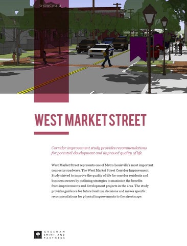
West Market Street Corridor improvement study provides recommendations for potential development and improved quality of life. West Market Street represents one of Metro Louisville’s most important connector roadways. The West Market Street Corridor Improvement Study strived to improve the quality of life for corridor residents and business owners by outlining strategies to maximize the benefits from improvements and development projects in the area. The study provides guidance for future land use decisions and makes specific recommendations for physical improvements to the streetscape.
West Mark et Street Corridor Improvem ents I N T E RVI E W /
J on H enne y , T re y R u d o l p h , J ohn C a m p b e l l
Why was GS&P hired to provide an improvement study for Louisville’s West Market Street Corridor?
Jon: West Market Street is a corridor that runs through three neighborhoods in the metropolitan section of downtown Louisville and serves as the economic Main Street for these neighborhoods. The project was initiated through Louisville Metro’s Economic Development Department and Councilwoman Cheri Bryant Hamilton. The purpose was to provide recommendations for physical improvements that could serve as a catalyst for redevelopment and reinvestment into this corridor, currently made up of low-income neighborhoods. How did you begin?
Jon: First, we had to understand how the corridor fit within these neighborhoods. We analyzed the corridor and separated it into character districts based on existing land use and a historic pattern of development, allowing us to provide the most momentum for reinvestment and stimulus to encourage new development in the area.
During what part of the process did you realize that the client grasped your vision?
Jon: It was a sequential process that began with outlining our plan, then sharing our findings with the corridor advisory group and in our broader public meetings. The data compiled from our inventory and analysis identified strengths and weaknesses as well as existing land use patterns. From there, we began developing recommendations for the character districts, which were described in both general terms and with very preliminary illustrations. Eventually, we progressed into a much more detailed set of illustrations that Trey produced, which presented a visual description of the transformation within each district when all the elements were combined. It was during review of the visuals that we realized the advisory group understood this project’s potential.
Explain the character districts and their importance in the study.
Jon: Character districts are commercial and neighborhood districts that have a central focus. For example, we coined the bridges district, which is mostly a desolate section in the center of the study area that runs underneath a railroad and an interstate overpass. Another character district is the campus district, which is a long city block where Shawnee High School is located. It has a different character, feel and make-up than the rest of the corridor. How did you determine the various districts and the implications of each?
What was their response to the visuals?
Jon: The group was very excited about the concepts presented in our preliminary illustrations and provided a lot of feedback in terms of what was important to them within each of the districts. With that input, we refined detailed illustrations
Judges' comments
Very successful... rich design solution showcase 3
of our final visions and presented the illustrations in the last round of public and advisory group meetings. Everyone was very pleased and excited to see the corridor’s potential direction.
gresham , s m ith and partners
John: The initial research phase was basically a block-by-block inventory. We walked most of the blocks and took inventory of the types and conditions of structures and the pedestrian and mobility components. It not only helped define the districts, but it also clarified which areas were economically the strongest with thriving retail. How did you involve the community?
Jon: For our proposal to be successful, we needed to have support from the citizens and stakeholders along the corridor,
Districts Commercial Residential Bridges Campus
Establishing character districts along the corridor and concentrating non-residential development into compact, walkable urban centers provide means to attract new development while also improving the quality of life for current residents. Streetscape design that responded to the context of the character districts provides opportunities to enhance the commercial districts as destinations while reinforcing the character of the neighborhood districts.
g resha m, s mith an d partners
showcase 3
The study gives specific recommendations for physical improvements to the streetscape, including pedestrian plazas, crossings, sidewalks and benches. These renderings illustrate possible improvements for Campus and Residential Districts.
showcase 3
gresham , s m ith and partners
so our public participation process was crucial. We created an advisory group made up of corridor stakeholders, which included business owners and representatives from the neighborhoods and school. Placing members of the community on the advisory committee created project ambassadors who could convey the intent of the project to the surrounding community and facilitate feedback from a broader constituency, rather than a small stakeholder group. What was the time and budget criteria?
Jon: This was a 14-month project. The client needed tangible recommendations, cost estimates and phasing options so they could secure funding and begin the improvements. Based on the information we provided, Councilwoman Hamilton was able to secure $1.2 million. They are now in the process of selecting a consultant to begin the construction documents
for implementation of the first phase of the project, which involves improvements to the four commercial districts. Your project was given very high marks for its social, economic and sustainable design considerations largely due to its focus on increased pedestrian traffic. How did your proposal plan to boost pedestrian usage through design?
Trey: One of the biggest limiting factors for the corridor was the small amount of right-of-way we had to work with, which also varied block to block. The walking, on-site land survey really helped in these areas. We looked at areas where sidewalks or other types of pedestrian movement were nonexistent or in disrepair and developed a plan to calm the traffic. Cars moved at rapid speeds through one particular area, so we had to devise ways to make the area more feasible for pedestrian activity, which often leads to more commercial appeal. What role did land- or streetscaping play in calming traffic and increasing pedestrian activity?
Trey: We incorporated streetscape elements to differentiate between each character district and help create a sense of place. We distinguished areas through the use of different types of pavement patterns and site elements. For instance, brick paving in the commercial areas is a uniquely different experience than the residential areas. We also placed more street trees in the residential districts, which provide a buffer between pedestrians and road traffic, making
g resha m, s mith an d partners
showcase 3
sidewalks feel safer. The plan also included corridor markers attached to the street lights to provide a sense of place for the corridor. Does your plan include specific safety features?
Trey: Yes, we proposed narrowing some of the drive lanes to reduce traffic speeds and also included bump-outs, which are periodic landscape islands that bring the curb line closer to vehicular traffic to visually slow down drivers. For instance, where there are two lanes of vehicular movement with parallel parking on either side of the street, we replaced one of the parking spaces with a bump-out to visually infringe upon the vehicle’s space. Jon: The bump-outs were applied primarily in the commercial districts at intersections to create a defined sense of place and allow wider pedestrian space. In the residential areas, we used road diets in areas where travel lanes were wider than they needed to be. This reduces the amount of pavement and allows more space for wider sidewalks or landscape buffer areas between the sidewalk and the edge of the curb. What were some of the public amenities used to unify the corridor?
Trey: In the commercial districts, we incorporated public benches and expanded the pavement on the corners to create a gathering space. Pedestrian street lighting was also used to make people feel safer at night. We also included public transit stops.
showcase 3
Jon: In the campus district, a number of high school students travel to and from school via public transportation rather than driving or using the public school bus system. We proposed building a covered shelter for that area to provide more seating and turn the transit stop into a pedestrian seating plaza associated with the entrance to the high school. Describe some of the design elements used to transition from each district.
Jon: The commercial districts have more hardscape and wider sidewalk areas to accommodate larger amounts of pedestrians and outdoor dining. There is also a higher concentration of iconic elements like pedestrian lighting, banners and seating. The residential district has less pedestrian lighting, more street trees, and fewer iconic elements to create a neighborhood feel. As you travel from one district to the other, these visual cues show you that you are moving to a different character and set of activities. Which part of the project did you find most gratifying?
John: Although it was certainly interesting to walk the corridor and study the architecture and hidden gems throughout, I really liked what Trey did with the illustrations by taking some of the components of the neighborhood and illustrating them to show the potential of West Market. That was most exciting to me. Trey: The most rewarding part for me, as a designer, was being able to include all of
gresham , s m ith and partners
the client’s needs in the overall plan. We took their feedback of what they liked and did not like, and modified our solutions to reflect their desires. Ultimately, we came up with something they are excited about. I do not know that I could top that with anything. Jon: As a professional planner, I have always enjoyed and appreciated working at the neighborhood level. When you are working with area residents to make physical improvements, they begin to see and understand how the changes are going to improve their lives. It is a very satisfying experience to have close interaction with people who are ultimately going to live with your recommendations and solution.
Existing
Alternative #1
Other recommended improvements include road diets to reclaim excess pavement and create pedestrian spaces, bump-outs to calm traffic, bus shelters to accommodate students, shade trees, and iconic lighting and furnishings to create a clear sense of place. Alternative #2
g resha m, s mith an d partners
showcase 3
Louisville Economic Developm ent Departm ent Louisville, Kentucky Landscape Architecture Planning
TEAM Princi pa l - in - char g e
Christopher H. Dickinson, P.E.
Project Mana g er
Jonathan D. Henney, AICP, ASLA
Project Pro f essiona l s
John Campbell Trey Rudolph, RLA Felicia Harper
www.gspnet.com ARCHITECTURE
ENGINEERING
INTERIORS
PLANNING
Gresham, Smith and Partners provides design and consulting solutions for the built environment that contribute to the success of national and international clients. For more than 40 years, GS&P has focused on enhancing quality of life and sustainability within communities. GS&P consists of industry-leading professionals practicing architecture and engineering design as well as scientists and highly specialized planning and strategic consultants in Aviation, Corporate and Urban Design, Environmental Compliance, Healthcare, Industrial, Land Planning, Transportation and Water Services. GS&P consistently ranks among the top architecture and engineering firms in the United States. For more information regarding GS&P, visit www.gspnet.com.