16 minute read
Preserving Another of Brunel’s Success Stories

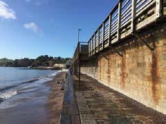
The construction of the sea wall at Dawlish was a very brave move by Isambard Kingdom Brunel. Also known as the South Devon sea wall, it was designed by Brunel and built by the South Devon Railway Company. The line takes a route from Exeter, following the River Exe to Dawlish Warren, runs beneath the sea cliffs to Teignmouth before following the River Teign to Newton Abbott. It follows tidal waters for about 13 miles of which four are open to the sea. A footpath runs alongside the railway between Dawlish Warren and Dawlish, while another forms a continuation of the sea front promenade at Teignmouth, together forming part of the South West Coast Path.
This section was opened by the South Devon Railway Company, running from Exeter St Davids railway station to Teignmouth railway station on 30 May 1846 and extended to Newton Abbot railway station on 31 December 1846. It was a broad gauge railway of 7 feet ¼ inch gauge and intended to be worked as an atmospheric railway, although atmospheric trains only ran from 13 September 1847 until 9 September 1848.
Advertisement
A section of the track hangs over the sea after the collapse of the sea wall (AP)
Damage to this route has been caused on many occasions but probably the most wellknown was that of the night of 4th February 2014 when, amid high winds and extremely rough seas, part of the sea wall at Dawlish was breached, washing away around 130 feet of the wall as well as the ballast under the track on the railway line behind it. The line remained closed until 4th April 2014 after extensive rebuilding work by Network Rail.
In 2010 it was stated in Parliament that "in recent years" around £9 million had been invested on keeping the sea wall safe and the cliff faces stable, and that the ongoing maintenance of the sea walls and the adjoining estuaries was costing Network Rail around £500,000 annually. The Under-Secretary of State for Transport reiterated the importance of the line to the economy of South Devon and Cornwall and confirmed that even if there were to be plans for the building of an alternative inland route in the future, "in our view, it would not be a substitute in any shape or form for the main line along the coast". This is despite the acknowledgement of an inevitable increase in maintenance costs due to rising sea levels.
New Approaches
In 2018, Network Rail put forward a proposal to extend the sea wall further into the English Channel at Teignmouth, with the wall's new edge passing through Sprey Point. The proposal would involve re-aligning the railway, moving the line further from the cliff and creating a space between the railway and the cliff to prevent the railway's being affected by cliff subsidence or collapse. Other elements of the proposal include the improvement of the sea wall between Kennaway Tunnel and Dawlish and the installation of an avalanche shelterstyle structure at Horse Cove. Government funding of £80 million to raise the sea wall south of Dawlish station by 2.5 metres (8.2 ft) was approved in February 2019.
Once complete the 1,250 feet section of new sea wall will be higher than the existing wall; it will have a curved edge to send waves back towards the sea; a high-level, wider and safer promenade; pedestrian access to the beach and an accessible station footbridge with lifts.
As part of Network Rail’s commitment to spending money locally, the scheme will also deliver an important boost to the south Devon economy with as much as £10 million expected to be spent with local businesses during the second phase of work. This follows the £5 million already spent on local labour, materials and accommodation during the first section of the new sea wall
Work in 2020, 2021 and 2022
The work, which will cost £80 million, was split into two programmes, the first programme of which was outlined in the October issue of Great Western Star and which was completed in the Autumn of 2020. It was officially opened by Rail Minister Chris Heaton-Harris on the
25 September. Work started on the second phase on Tuesday 10th November 2020 and it is anticipated that this will take two years to complete. It comes after years of detailed studies, designs and joint working between world-leading marine, coastal and railway engineering experts.
Arup was commissioned by Network Rail to prepare a GRIP 3 Option Selection Report for proposed new sea defences for Dawlish station and adjacent sections of railway as well as an accessible footbridge within the Dawlish station area. Dawlish station is located on the London Paddington to Plymouth line and is served by trains running between Exeter and Newton Abbot.
The section of track considered in this project is MLN1 205m 75ch to 206m 10.5ch which runs parallel to the beach at Dawlish from the Colonnade breakwater to the Coastguard’s breakwater (C2C). This section of railway is included in the South West Rail Resilience Programme by Network Rail. The aim of the scheme is to protect the railway for the next 100 years by improving the existing sea defences, following the emergency repairs that took place in 2014. The C2C project aims to provide protection to the railway and platforms, while still maintaining access to the coastal path and beach front. Included within the works, is an accessible footbridge within the platform area which will replace the existing barrow crossing at the southwestern end of the station. This work was carried out with an emphasis on the buildability of the design as well as considering aspirations for wider a platform 1.
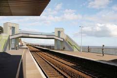
Artist’s impression of accessible footbridge
From the outset of the project the frontage of beach between the two breakwaters was split into several sections to make the design process easier. Each section has its own unique interface with the beach front and the track behind, requiring different designs for the separate sections.
At the South-Western end of the section is the Marine Parade interface. This is a small section of the Marine Parade section that was specifically designed so that it could act as a connection for this new section of works.
Section A is arguably the most complicated section. This area contains the Dawlish Water basin, where the river runs out into the sea, as well as the town gateway area. It provides access from the town via the Colonnade underbridge, a structure carrying the railway over Dawlish Water.
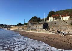
Section B is a small section of low-level promenade between the town gateway area and the listed station building. At the rear of the promenade are listed colonnades that support the station platform. This area also connects to beach level via a ramp and is the main access to the beach.
Section C is the area around the listed station building. The complication with this section is the building façade that faces the beach as it needs to be displayed as much as feasibly possible. This is the original frontage for the station that has stood since the 1800s and so any work in front of this section is sensitive.
Section D forms the bulk of the section and spans from the end of the station building all the way until the coastguard’s footbridge at the North-eastern end of the section. The half closest to the station building has a low-level promenade and a platform overhang supported by wooden colonnades. The northern half consists of the low-level promenade with a narrow platform. A set of stairs leading to the beach is present at the midpoint.
Section E is a wider section that houses the Boathouse building and access to the Coastguards footbridge.
Section F is as wide as section E as it contains the Coastguards boat ramp as well as a link to the next section of promenade beyond the breakwater. This section will need to be similar to the Marine Parade interface, providing access to the beach and the existing promenade as well as offering an opportunity to be extended in the future to potential upgrades of the section beyond.
A key decision during the option selection process was the division of the works into two main parts; ABC & DEF. This meant the bulk of the work involving section D could be

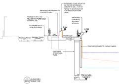
Cross section view of sea wall from Dawlish beach The new sea wall and promenade
accelerated whilst the more intricate details surrounding the town gateway area could be investigated separately.
Based on scientific modelling and laboratory testing of various options by world experts, we propose to protect the railway and station by constructing the following measures to increase resilience to extreme weather and tides, and provide enhanced amenities for local people and passengers: • The construction of a new, taller sea wall between the two breakwaters. • A wider, taller, public walkway incorporated into the wall with views onto the beach. • Reconstruction of the timber Dawlish station seaward platform. • A new, accessible station footbridge with lifts. • New pedestrian ramped access to the beach from the promenade. • Improved passenger experience through better protection from the sea.
New sea wall and promenade
The new, taller sea wall, with a high-level promenade, will be built in concrete precast panels. It will run from the new ramps/ access that are being built at the west end of Dawlish station, all the way to the Coastguards breakwater. The new wall will add 4.2m to the height of the current 3.8m promenade, and its toe will extend, on average, 2.8m further out towards the sea. The wall includes a recurve at the top, as at Marine Parade, to help deflect waves and reduce ‘overtopping’ of water onto the track.
The new high-level promenade, which will be at approximately the same height as the current platforms, will provide a more spacious, safer, level surface for users. It will be wider than the current promenade (varying from 3m to 4m) and users will be protected by a curved parapet wall on the seaward side which is approximately waist height (1.1m). This forms part of the wall's overall height. There will be a number of raised points with benches along the promenade. This will allow more people to enjoy the views as the parapet will be reduced to 0.8m with a small railing on top.
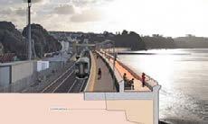
Artist’s impression view of new promenade towards Dawlish station with train
The section from Dawlish station to the Coastguard breakwater east of the station is expected to be completed in late 2021, while the section between the station and the Colonnade breakwater, which will link up with the new wall at Marine Parade, will start to be built shortly after.
Dawlish Water Basin and Colonnade Breakwater
Colonnade Breakwater is at the high chainage end of the site and is approximately 375feet long. To the land end of the breakwater is the main pedestrian access to the beach at Marine Parade. Adjoining the breakwater is a drainage basin where Dawlish Water

Dawlish Water Basin and Colonnade
discharges into the sea. The basin consists of concrete walls which form a retained area reducing sediment flow from Dawlish Water into the sea.
To improve resilience, the existing ‘stilling basin’ boundary wall will be reconstructed on its existing footprint with a much stronger structure. This will take energy out of the waves and extend the life of the basin. The reduction in energy will reduce some of the beach material being deposited under the viaduct and protect the new link bridge and existing structure.
Depending on rising sea levels, it is possible that further work to the basin will be required in 30 to 40 years. We are carrying out modelling to assess this.
Station Building
The original station was built in 1846, with the current station structure resulting from major rebuilding in 1875 after a fire destroyed the original station. The station consists of two separate buildings, one on each platform. The Italianate frontage added in the rebuilding is of significant architectural and historical note and is one of the major reasons for the station being grade II listed.
The station itself was not able to perform to the required resilience criteria. As a result, options were developed to protect this section while reducing any impact on the building, in particular the façade. This meant that ramps in front of the building were not preferred due to the changing level across the façade. Due to its listed status, listed building consent is required in order to carry out any work around the station and platforms which would affect the nature of the station.
Platforms at the station have a modern asphalt surface with concrete coping stones and the customary yellow line. There are no tactile pavers. The platforms have been extended over
Existing timber platform

Artist’s impression of the new sea wall, platform and promenade
time, most notably the up platform to the south (which was rebuilt in the 1940’s using available materials of the time and so is supported by repurposed cast-iron gas lamp pillars), and north over the promenade below, which took place in the early 19th century. This section of the platform has been rebuilt most recently after, and as a result of, the storms of 2014, with it potentially having been rebuilt a number of times prior to this too. Towards the lower chainage end the up platform was extended in 1934 and narrows to a point where it is no longer suitable for access by passengers, as enforced by signage. Canopies are provided over the areas of platforms adjacent to the station buildings, these were installed in 1961, replacing earlier steelwork roofs. Additionally, the traditional GWR sign is present on the southern end of the up platform.
Promenade
The existing promenade sits between the beach and the station platforms, at around +3.8mOD. Narrow concrete sets of steps between the promenade level and beach level are provided near to the Coastguards boathouse and roughly halfway along the
down platform. Behind the basin at the outfall of Dawlish Water the promenade drops to +3.2m as it passes below the viaduct, with a headroom of 2.4m to the soffit. Situated to the rear of the promenade is the existing sea wall, which has been split into two sections (D1 & D2) for clarity.
Sea Wall (Section D1)
The existing sea wall that extends from the down platform station building to the end of the wider portion of platform 1 sits to the rear of the promenade and is topped with the overhanging platform structure. The overhanging timber structure is supported by evenly spaced timber columns, and the soffit of the structure is formed of timber planks, containing the platform structure.
Drainage ducts run through the wall from both the above and below track areas. It has been noted from site visits that some of these ducts are occupied by nesting pigeons.
Beyond the narrowing of platform 1, the sea wall takes on a modified typical section, this time with the platform cantilevering from the top of the sea wall without additional propping support from the promenade. The overhang of the platform varies, starting at around 700mm reducing towards the north to a point where the railing is affixed directly to the top of the wall and there is no overhanging extension. This area of the platform atop section D2 is not generally accessible to passengers (enforced by signage) and is only used for the disembarkation of passengers wishing to alight from the rearward coaches of 9 car and 5+5 car IET trains.
Coastguard’s Footbridge
The Coastguard’s footbridge is a post tension concrete deck dating back to the early 1950’s and is situated towards the north eastern end of the site.
This is not a listed structure but does form part of the Brunel heritage railway, and the granite structure of the stairs (along with the adjacent Coastguard’s Boathouse) form the surviving elements from the early years of the line. The stairs are not a modern structure and are not compliant with modern standards. It appears that the bridge deck has been replaced with a precast concrete deck which is newer than the stairs. The bridge appears to be in a reasonably good condition, particularly considering the aggressive environment in which it is located.
Coastguards Boathouse
The Coastguards Boathouse is also part of the Brunel heritage of the area but is also not listed; however, as previously mentioned is some of the oldest structures related to the railway in the area.
It was owned by a 3rd party at the start of the scheme and is located just beyond the footbridge at the north eastern end of the site. Network Rail has now purchased the building. The arched doorway in the southern elevation has been infilled, with the large doors on the north elevation retained.
Sections of Bullhead rail have been set in the concrete ramp leading to the large door, presumably once holding some sort of separating structure which has been destroyed by previous storms. The remaining steel sections are significantly corroded, with the web of the rail completely corroded away in some examples.
The roof is in very poor condition and, in December 2019 Network Rail arranged the removal of the tiles of the roof to prevent them being blown onto the track. To achieve the level of resilience required by providing a much higher sea wall, the Coastguards boathouse, owned by Network Rail, will be demolished to enable the height of the promenade/sea defence to be increased.
A footprint will be left to show where the building stood, and it is planned to reuse the stone in constructing new public benches within the project. The bottom section of the existing footbridge steps at this location will also be adjusted.
Coastguards Breakwater
At the low chainage end of the site is Coastguards Breakwater, which is approximately 165 feet long. At the land end of the breakwater the promenade ramps up to the level of the breakwater, and splits into a pair of ramps, one adjacent to the track connecting to the higher promenade to the north; between this and the breakwater is a second ramp which connects down to the beach level to the north of the breakwater.
Innovative Engineering Following in Brunel’s Footsteps
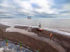
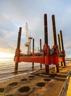
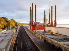
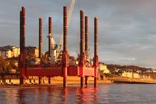
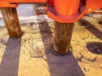
A major aspect of this work involves the use of an innovative eight-legged, selfcontained walking jack-up barge, known as a ‘Wavewalker’. It is the only one of its kind in Europe and it will be the first time this type of barge has been used to maintain the UK rail network.
This innovative piece of equipment is being used by contractors BAM Nuttall to safely access the sea face of the railway embankment along Marine Parade and to help deliver the piling at the sea wall. The ‘Wavewalker’ benefits from being able to operate across the high tidal ranges that particularly impact the south Devon coastline and which would otherwise restrict the number of hours it is possible to safely work on the sea wall.
On Sunday 8 November the WaveWalker Jack-up barge arrived into Dawlish. Over approximately three months, it is installing around 280 piles between Dawlish station and the Coastguard breakwater, which will form the foundation of the new sea wall.