OFFICIAL
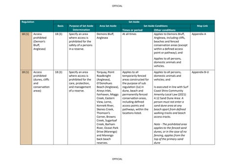
Regulation
18 (1)
Access prohibited (Demon’s Bluff, Anglesea)
Set Aside Basis
Purpose of Set Aside Determination
18 (3)
Specify an area where access is prohibited for the safety of a persons in a reserve.
Area Set Aside
Demons Bluff, Anglesea
Set Aside Conditions
Times or period At all times
Other conditions Applies to Demons Bluff, Anglesea, including cliffs, beaches and fenced conservation areas (except within a defined access point or pathway); and
Map Link
Appendix A
Applies to all persons, domestic animals and vehicles. 18 (1)
Access prohibited (dunes, cliffs and conservation areas)
18 (3)
Specify an area where access is prohibited for the care, protection, and management of a reserve.
Torquay, Point Roadknight (Anglesea), O’Donohues Beach (Anglesea), Aireys Inlet, Fairhaven, Moggs Creek, Eastern View, Lorne, Kennett River, Skenes Creek, Thomson’s Corner, Browns Creek, Sugarloaf Creek, Barham River, Ocean Park Drive (Marengo) and Marengo back beach reserves.
OFFICIAL
Applies to all temporarily fenced areas constructed for the purpose of sub regulation (1a) in dune, beach and permanently fenced conservation areas, including defined access points and pathways, within the locations listed.
Applies to all persons, domestic animals and vehicles; and Is executed in line with Surf Coast Shire Community Amenity Local Law (2021) 4.12 Sand Dune Area: A person must not enter a sand dune area at any beach apart from defined walking tracks and beach access tracks. Note - The prohibited area applies to the fenced sand dunes, or in the case of no fencing, applies from the top of the primary sand dune
Appendix B-U
OFFICIAL
18 (1)
18 (1)
Access prohibited (Hooded Plovers)
Access prohibited (Twelve Apostles Visitor Centre)
18 (3)
18 (2) (a)
Specify an area where access is prohibited for the care, protection, and management of the Hooded Plover (Thinornis cucullatus)
Specify an area to manage visitor access to the Twelve Apostles Visitor Centre and associated visitor facilities in order to protect public safety, manage visitor capacity, facilitate commercial operations, protect
Torquay, Point Roadknight (Anglesea), O’Donohues Beach (Anglesea), Aireys Inlet, Fairhaven, Moggs Creek, Eastern View, Lorne, Kennett River, Skenes Creek, Thomson’s Corner, Browns Creek, Sugarloaf Creek, Barham River, Ocean Park Drive (Marengo) and Marengo back beach reserves. Applies to all areas behind the entry and exit boom gates at the Twelve Apostles Visitor Centre, Princetown, within the areas set out in Appendix V
OFFICIAL
Applies to all temporarily fenced areas constructed for the purpose of sub regulation (1a) in dune, beach and permanently fenced conservation areas, including defined access points and pathways, within the locations listed.
Applies to all persons, domestic animals and vehicles; and
Appendix B-U
Is executed in line with Surf Coast Shire Community Amenity Local Law (2021) 4.12 Sand Dune Area: A person must not enter a sand dune area at any beach apart from defined walking tracks and beach access tracks. Note - The prohibited area applies to the fenced sand dunes, or in the case of no fencing, applies from the top of the primary sand dune.
At all times
Applies to all persons, domestic animals and vehicles; This set aside limits access to the following persons or class of persons: - persons holding a valid booking, ticket, licence or permit;
Appendix V
OFFICIAL
infrastructure, and support the efficient operation of the precinct
- authorised employees of the Great Ocean Road Coast and Parks Authority; - contractors engaged by the Great Ocean Road Coast and Parks Authority; - emergency services personnel; - persons authorised in writing by the Great Ocean Road Coast and Parks Authority Vehicles must only enter via designated entry points. Vehicles must comply with directions of traffic management staff Access may be suspended immediately due to emergency incident, public safety risk or operational requirements.
OFFICIAL
OFFICIAL
Appendix A: Demons Bluff, Anglesea
OFFICIAL
OFFICIAL
Appendix B: Torquay
OFFICIAL
OFFICIAL
OFFICIAL
OFFICIAL
OFFICIAL
OFFICIAL
OFFICIAL
OFFICIAL
OFFICIAL
OFFICIAL
Appendix C: O’Donohues Beach (Anglesea)
OFFICIAL
OFFICIAL
Appendix D: Point Roadknight (Anglesea)
OFFICIAL
OFFICIAL
Appendix E: O’Donohues Beach (Anglesea)
OFFICIAL
OFFICIAL
Appendix F: Aireys Inlet
OFFICIAL
OFFICIAL
Appendix G: Painkalac Creek (Aireys Inlet)
OFFICIAL
OFFICIAL
Appendix H: Fairhaven – Moggs Creek
OFFICIAL
OFFICIAL
Appendix I: Moggs Creek
OFFICIAL
OFFICIAL
Appendix J: Fairhaven – Moggs Creek
OFFICIAL
OFFICIAL
Appendix K: Lorne
OFFICIAL
OFFICIAL
OFFICIAL
OFFICIAL
Appendix L: Kennett River, Sugarloaf Creek, Thomson’s Corner, Brown’s Creek
OFFICIAL
OFFICIAL
Appendix M: Skenes Creek
OFFICIAL
OFFICIAL
Appendix N: Skenes Creek
OFFICIAL
OFFICIAL
Appendix O: Skenes Creek
OFFICIAL
OFFICIAL
Appendix P:
OFFICIAL
OFFICIAL
Appendix Q:
OFFICIAL
OFFICIAL
Appendix R: Barham River
OFFICIAL
OFFICIAL
Appendix S: Barham River
OFFICIAL
OFFICIAL
Appendix T: Ocean Park Drive (Marengo)
OFFICIAL
OFFICIAL
Appendix U: Marengo back beach reserves
OFFICIAL
OFFICIAL
Appendix V: Twelve Apostles Visitor Centre
OFFICIAL