4 minute read
Capturing the reality of land surveying


By Andrew Weeks
It’s not virtual reality — it is reality capture.
Nor is the technology exactly new, but it is the future of land surveying, according to professionals at Houston Engineering, who say it is advancing the ways in which data is gathered and how that information is processed to create designs for, in the company’s role, infrastructure projects.
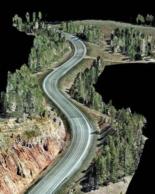
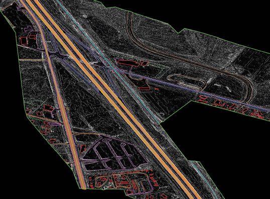
Think of reality capture as a high-end, cost-effective survey solution that goes beyond traditional survey methods. It uses LiDAR — which stands for Light Detection and Ranging — to create high-resolution models of ground elevation.
Chad Qualley and Erik Nelson, drone operations manager and senior technician, respectively, said Houston Engineering, based in Fargo, N.D., has been at the forefront of providing reality capture services that can be used in a variety of applications for clients across continued From page 54
The center’s researchers will look at modifying the drug to make it better absorbed or long acting. “To reduce toxicity, we can perhaps put the drug in a delivery system that targets the tumor,” Perumal said. “It’s like taking an old car and refurbishing it.”
One classic example of repurposing is aspirin, a 100-year-old drug. In its original form, the pain reliever can cause increased bleeding on long-term use. Taking clues from this side effect, the repurposed, lowdose aspirin is now commonly used to prevent blood clots in those with cardiovascular disease - and has also been shown to lower the risk of colorectal cancer.
Targeting cancer, corneal transplants
During the next five years, four research projects with high potential for competing for external federal and private funding and developing technologies of interest to industry partners will receive center funding for a maximum of two years. The first two projects will begin next year.
The first project, led by professor Hemachand Tummala, will further develop a targeted therapy designed to reduce the side effects and the upper Midwest. The survey service improves accuracy, productivity, quality and safety throughout clients’ infrastructure projects.
“LiDAR is actually one of the tools that we use for reality capture and it’s one of the biggest ones, really,” Nelson said. “When you can spray an area with billions and billions of points, you basically get a right-now image capture of what’s going on at the site you want to capture.”
LiDAR works like this: A laser scanner transmits brief pulses of light to the ground surface. When reflected back, their travel time is used to calculate the distance between the laser scanner and the ground, according to the U.S. Geological Survey. Data is collected as a “point cloud” or dataset “of individual points reflected from everything on the surface, including structures and vegetation.” increase the effectiveness of a commonly used chemotherapy drug. The initial disease target is ovarian cancer. The team includes associate professor Komal Raina, the Haarberg Chair in Cancer Research, along with Avera Cancer’s chief medical officer Dr. John Lee.
A second project, led by associate professor Gudiseva Chandrasekher, responds to the shortage of quality, implantable donor corneas by developing a new biomaterial for making corneal implants. South Dakota Mines assistant professor of nanoscience and engineering Scott Wood will also work on the project. The team will have guidance from ophthalmologist Vance Thompson.
During the center’s third year, a team led by Perumal, will advance a drug formulation to prevent and/or treat early-stage breast cancer using a South Dakota Innovation Partners-licensed delivery method. Also, in year three, professor Xiangming Guan will lead a team developing a targeted drug-delivery system to treat metastatic brain cancer.
Besides these lead projects, the center will also provide funding for new interdisciplinary projects by soliciting grant applications from academic and private institutions in the state.
“This new center will give us a big boost and expedite these research projects by at least five years,” Perumal said. “We are fortunate to have a state interested in investing in people and research.”
LiDAR, of course, is nothing new. It has been around a long time, Qualley said, and he’s been using it ever since he arrived at Houston 18 years ago. “But it has really changed,” he said, mainly because other technology has changed.
“The sensors that shoot the lasers, which is LiDAR, have gotten to be so much more precise and so much more inexpensive,” Qualley said, explaining that LiDAR can now be used on much smaller projects than in the past.
Qualley described himself and Nelson as “software experts” who run “various specialized software” that allows them to process the “point cloud that the LIDAR sensor shoots and extracts from.”

It is similar to having a field survey crew on site, extracting information from all points of a location.
“We’re extracting out road edges, we’re extracting out signs, we’re extracting out a grid of points that then can be used to make surfaces,” Qualley said. “It’s really changed.”

To give another example of what has changed, traditionally high-altitude LiDAR has been captured with a plane, but new aerial LiDAR techniques can use a helicopter or unmanned aerial system that can fly safely continued on page 58 at lower altitudes to help produce more detailed results. Nelson said mobile LiDAR can capture images close to the ground with a device mounted on a vehicle.


What’s on the horizon with reality capture is anybody’s guess, because technology changes so quickly. Even over the past couple of years, the team at Houston Engineering has seen it evolve and enhance.

“The sensors have gotten immensely better in the last four or five years, even over the past couple of years,” Nelson said. “It’s just been insane how they’ve changed the style and the ability of each sensor and then each iteration gets that much better than the last one.
“So, going into the future it’s only going to get that much better. The sensors are going to get smaller, they’re going to get more accurate. It’s just going to continue going that way.”
He said drones also will get better and, fingers crossed, eventually be able to carry more weight. Sensors are heavy for a drone.
“That’s one limitation we have,” Nelson said, “but hopefully we can get drones that can carry better sensors. So, that’s what I see in the next five years, that reality capture will just keep getting better and better with technology.”
ANDREW WEEKS PRAIRIE BUSINESS EDITOR