23 minute read
WORLD HERITAGE SITE STRATEGIA COMPLESSIVA DI GESTIONE THE DOLOMITES OVERALL MANAGEMENT STRATEGY


cultural events,topresentthe DolomitesUNESCOinEXPO2015
WTE - World Tourism Expo
ExhibitorwithstandattheWorld TourismExpoofUNESCOWorld Heritagecities andsites
MCMkt Cons.-Ass.of UNESCO ItalianSites
EXPOMilan 2015
WTE-World TourismExpo cyclical
MITT
MoscowInternationalTraveland TourismExhibition
BIT Milan 2012 Attendanceoftradefair,distributing materialfromtheFoundationonthe stands oftheindividualprovinces
The Dolomites UNESCO T3 portal
Developmentofacommunication tooltohelpguideandinformthe generalpublic,residents andmost importantly tourists abouttheintrinsic valuesofTheDolomitesWHS
ProgettoSrl MITT cyclical
Fondazione DU BIT Milan 2012 cyclical
Municipality of SagronMis The Dolomites UNESCOT3 portal concluded (2014)
The Dolomites UNESCO A22 video
Motorway signs on the Brennero A22 motorway
Meridiani Montagne - booklet about the Dolomites
The Dolomites - the heart of stone in the world
TCI meeting in the Cadore Dolomites
VideotobeshownontheA22 motorwaynetwork -Autostradadel Brennero
Motorwaysigns ontheBrennero A22motorway
Publicationofbookletaboutthe Dolomites -MeridianiMontagne
Photography exhibitionorganisedby NationalGeographicGermany of photographs oftheDolomites
Meetingtocelebrate120yearsof theTouringClubItalianoassociation
Asteria MultimediaSrl The Dolomites UNESCO A22video
Autonomous Provinceof Trento
Motorway signsonthe BrenneroA22 motorway
Editoriale Domus Meridiani Montagnebookletabout theDolomites
National Geographic Germany theDolomites -theheartof stoneinthe world
TouringClub Italiano TCImeeting intheCadore Dolomites
Documentary 'Dawn in the Dolomites' Documentary RAI Documentary 'Dawninthe Dolomites'
Publication of 'Italian UNESCO World Heritage sites'
Publicationof 'ItalianUNESCO WorldHeritagesites'
Associationof Italian UNESCOWH Sites
Publicationof 'Italian UNESCOWH Sites ongoing concluded (2013) concluded (2013) concluded (2011) concluded (2013) concluded (2013) concluded (2012) legend The terms of reference used in the tables of the Executive Programme and the Operating Plans are: objectives defined according to the requests of the WH Committee, the guidelines drawn up by the Networks, the research carried out by the FD4U and the themed proposals arising from #D2040. actions based on the principle of feasibility, in other words the possibility of achieving concrete results within the short-term time frame (2020), and on relevance, the possibility of implementing activities either ongoing or scheduled for the near future, which are coherent or compatible with the OMS. current and planned activities summary of the activities which are currently ongoing or have already been scheduled, and the projects that need developing to accomplish the project’s strategic actions implementers identifying those responsible for each of the activities and projects is one of the strengths of the OMS as it allows objectives to be disseminated and involves all the stakeholders (institutional, public and private) reference area specifies if the activities and projects are organised or have an effect within the core zones, buffer zones, transition areas or reference area application level establishes if the activities or projects are carried out locally / precisely, and if they involve a single component site or the whole Property implementation instruments lists the instruments that are already available to execute the activities and projects, relating to both economic planning and forestry, rural and land management; resources the availability of resources is the main hurdle when organising activities and projects; resources are not only of a financial nature but can also refer to skills and expertise, and all existing sources must be used implementation priority defines how the strategic actions are prioritised (short term = 5 years, medium term = 15 years, long term = 25 years); priorities are established according to criteria of effectiveness, efficiency and financial feasibility. implementation status evaluates the overall degree of accomplishment of the strategic actions, on the basis of the activities and projects as a whole listed directly in the operating plans interaction of actions potential interactions with other activities are signalled. This helps identify possible synergies and optimise both the financial and human resources performance indicators indicators must be predictive, available, measurable and sustainable, meaning that gathering them must not be a drain on financial resources; the indicators are established taking the characteristics of the Dolomites area into account and can differ from component site to site, according to the management and conservation objectives reference standards the ideal condition to reach or maintain, based on the environmental, economic and social sustainability requirements of each action monitoring the implementation status indicates the method and frequency of the monitoring activities; it is the instrument used to control and periodically measure the phenomena and the management actions, an essential aspect of the adaptive strategy process.
1 Referencestudies Andguidelines
The reference studies and guidelines are a series of investigative tools used to build up the knowledge base (they are taken from a variety of studies, further investigations, elaborations) which the FD4U and the Networks have carried out to date. They are a means of reflecting the substance of The Dolomites WHS and defining the interpretive model of the Property (cf. adaptive management).
cartogrphic data set Creation of a single cartographic database for the whole Dolomites, WHS with an unequivocal georeferencing system and standardised representation of the different themes.
http://www.dolomitiunesco.info(reservedentry)
GeologicalHeritageON+ LandscapeHeritageON geological excellences Guidelines to identify the representative features of the geological and geomorphological heritage of the Property; dataset of geosites relating to potential geotourism. [scheduled for 2016]
GeologicalHeritageON
Dolomites UNESCO invariant Guidelines for the harmonisation of the spatial planning instruments used to control infrastructures, settlements and buildings.
Guidelines Landscape and landscapes in the Dolomites - Research report http://www.dolomitiunesco.info/?pubblicazioni=pubblicazione-di-prova LandscapeHeritageandProtectedAreasON features o dolomite landscape Guidelines to identify the main landscape units and indications on how to represent the Landscape Units in the Property in spatially explicit and cartographic terms. The Landscape Units are also characterised according to the dynamic processes of the landscape, focusing particularly on the processes linked to the water cycle and the structures which support anthropic activities related to production systems.
Guidelines Landscape and landscapes in the Dolomites - Research report http://www.dolomitiunesco.info/?pubblicazioni=pubblicazione-di-prova LandscapeHeritageandProtectedAreasON obsolete infrastructures Guidelines for compiling a list of structures of little or no interest which should be eliminated in order to restore the natural landscape (restoration of human-disturbed World Heritage natural landscape). Elimination criteria are defined according to: negative impact on the environment and landscape; low social, historical, cultural and emotional value; absence of any kind of possible use in the present or future.
Guidelines Landscape and landscapes in the Dolomites - Research report http://www.dolomitiunesco.info/?pubblicazioni=pubblicazione-di-prova LandscapeHeritageandProtectedAreasON carrying capacity Research on the limits of acceptable change (LAC), on the impact and positive or negative effects of the human activities in the Propertys areas, identification of performance indicators and methods of assessing / evaluating management effectiveness.
Assessment models for the coordination of territorial policies http://www.dolomitiunesco.info/wpcontent/uploads/2016/01/DEF_FD4U_rapporto-finale-CC-2015.04.30.pdf
Tourism, Mobility and Development ON + Training and
ResearchON
management effectiveness Study of a procedure for assessing management effectiveness based on the assessment models recommended by international organisations (WHC, IUCN/WCPA, WTO, UNEP) and specifically adapted to the Property, aimed at evaluating sustainable development in densely populated mountain areas which are traditionally managed by the local communities.
Assessment models for the coordination of territorial policies http://www.dolomitiunesco.info/wpcontent/uploads/2016/01/DEF_FD4U_rapporto-finale-CC-2015.04.30.pdf
Tourism, Mobility and Development ON + Training and ResearchON indicators and standards Study to compile a set of performance indicators taken from different sources (literature, experience of management and professional organisations) and define the methodologies to identify qualitative standards that could be applied to the Property.
Assessment models for the coordination of territorial policies http://www.dolomitiunesco.info/wpcontent/uploads/2016/01/DEF_FD4U_rapporto-finale-CC-2015.04.30.pdf
Tourism, Mobility and Development ON + Training and ResearchON interpretive model of the Property Development of an analytical and operational tool, representing the structure of the serial Property, the existing links and the potential connectivity among the c.s.. The model identifies the different situations throughout the territory, the kinds of connections or corridors, and determines the most appropriate indicators for the different situations.
Assessment models for the coordination of territorial policies http://www.dolomitiunesco.info/wpcontent/uploads/2016/01/DEF_FD4U_rapporto-finale-CC-2015.04.30.pdf
Tourism, Mobility and Development ON + Training and ResearchON visitor profile Visitor survey on provenance, expectations, awareness of the Property being inscribed on the WHL, behaviour and satisfaction with certain specific aspects of their visit in the territory of the Property. Sustainable tourism in the Dolomites. In-depth analysis. http://www.dolomitiunesco.info/?pubblicazioni=linee-guida-del-turismo
Tourism,MobilityandDevelopmentON tourist operator profile Survey of the expectations of local tourist operators, their awareness of the Property being inscribed on the WHL and of the UNESCO Dolomites Foundation, their behaviour and their perceptions of certain specific aspects of the visitor experience. http://www.dolomitiunesco.info/?pubblicazioni=linee-guida-del-turismo
Sustainable tourism in the Dolomites. In-depth analysis.
Tourism,MobilityandDevelopmentON conservation measures List of the conservation measures for the environment and natural landscape, completion of the management plans of the protected areas, creation of a network to improve common measures, identification of appropriate measures for the non-protected areas.
Analysis by Dolomiti UNESCO Natura 2000 Network: Hypothesis of Regulatory Harmonisation and Management of The Dolomites UNESCO "5% areas" http://www.dolomitiunesco.info/wpcontent/uploads/2015/11/Documento_Armonizzazione_finale_rev.pd LandscapeHeritageandProtectedAreasON parks networking Survey and mapping of the projects involving the parks in the World Heritage Site; sharing of the “network” projects to be implemented in the short-, medium- and long-term.
Analysis by Dolomiti UNESCO Natura 2000 Network: Parks Network http://www.dolomitiunesco.info/wpcontent/uploads/2015/11/Documento_Armonizzazione_finale_rev.pd LandscapeHeritageandProtectedAreasON promotion of sustainable tourism
Definition of the guidelines (indications and tools) to promote and communicate the special values of the Property to tourists, identification of the segments/products to focus on to develop sustainable tourism, establishing potential sources of funding.
Guidelines for the promotion of sustainable tourism in the Dolomites
UNESCO http://www.dolomitiunesco.info/wp-content/uploads/2016/01/ DEF_290515_Linee-guida-promozione-Dolomiti-Unesco.pdf PromotionofSustainableTourismON - accessibility to the Property and mobility Survey to establish how easy it is to reach the main access points of the Property using public transport, comparison with the behaviour of visitors as regards movement towards and between the areas of the WHS, monitoring and analysis of traffic flows within the Property. Analysis of accessibility using public transport - http://www.dolomitiunesco.info/?pubblicazioni=linee-guida-del-turismo
Tourism,MobilityandDevelopmentON - mobility in the passes Surveys on traffic flows and noise and environmental emissions in the main Dolomite passes, the different means of transport and the behaviour/preference of the different types of visitors, the opinions of the local stakeholders and gathering of information suggesting possible management solutions.
The Dolomite passes. Analysis of traffic and its impact with proposals on how to manage it http://www.dolomitiunesco.info/attivita/i-passi-dolomitici-pubblicato-lo-studioeurac-commissionato-dalla-fondazione
Tourism,MobilityandDevelopmentON - expectations of the local population
Participatory process #Dolomites 2040 aimed at examining the expectations of the stakeholders and the local population regarding UNESCO inscription, and at involving them in the definition of the objectives and management plans, sharing ideas and practical suggestions.
Processo Partecipativo "#Dolomiti2040", Report Finale http://www.dolomitiunesco.info/dolomiti2040-il-report-conclusivo http://www.dolomitiunesco.info/wp-content/uploads/2015/11/FD4UD2040_PP_report-finale1.pdf
FD4U
2
Whsinterpretivemodel
The interpretive model of The Dolomites WHS shows the relationship between the structure of the serial Property and the existing links, and the potential connectivity between the individual c.s. and the Dolomites area as a whole 1 .
The aim of the model is to simplify this complex Property and help identify the reference areas and levels of application which are key to assessing the strategic guidelines and are contained in the operational plans.
The main focus of the OMS of the Dolomites UNESCO Property is the conservation of its OUV and the ecological and sustainable development of the reference area of this World Heritage Site.
To achieve this, the interpretive model provides a breakdown of the c.s. of The Dolomites WH and its surrounding areas, classifying the areas which are important for conservation of the OUV (core zones and buffer zones).
It also defines the reference area (which corresponds to the so-called “Dolomites territory” defined as the "cultural and geographical context" of the WHS) 2, in other words the larger region comprising the territories surrounding the Property itself.
The model is particularly useful because it provides a more simplified and controllable presentation of the processes and relationships which would otherwise merely appear as numbers or data in tables (e.g. flows at altitude or between the various c.s., the effects of traffic on the passes, organisation of access points and hot spots, spatial and functional relationships between landscape units, etc.).
It is also an invaluable tool for assessing transformation scenarios and for guiding development towards sustainable goals in the Dolomites area. The World Heritage is actually located in a highly dynamic socioeconomic context and, as a result, any activities or transformations involving the areas downstream of the Property have an inevitable effect on the upstream areas, causing pressure and potential conflicts of interest.
Representing the interactions between the areas within and outside the Property and their causes only goes to highlight how important the links are for conservation purposes and how they can contribute to the sustainability of the development.
functionallinkages Inscription criteria VII and VIII of The Dolomites WHS define aspects that are not limited exclusively to the core zones but to the buffer zones or outside areas. The notion of “integrity”, referred to in the OG 3 ,
1 See Ponticelli, L. and Micheletti, C. (2014). Modelli valutativi per i processi di coordinamento delle politiche territoriali , FD4U and MATTM, Cortina I.
2 Referring to the decision of the Board of Directors of the FD4U on 21 June 2011 which approved the operational manual of the Property brand and the attached list of the municipalities belonging to the so-called “Dolomites territory“, which the brand can be granted to. The “Dolomites territory” includes the areas which are in various ways linked to and/or associated with the WHS and defines the reference area of the Property in the strict sense of the word.
3 WHC.15/01 (8 July 2015) Operational Guidelines for the Implementation of the World Heritage Convention. UNESCO see. chapter II.E connectivity conservation suggests widening assessment to include the areas surrounding the World Heritage Site 4 .
The operational model helps clarify the role and importance of the functional links in OUV conservation and eco-sustainable development. The IUCN paradigm of connectivity conservation 5 and the UNESCO biosphere reserve paradigm 6 were both referred to when defining functional linkages.
These references, however, cannot be applied to The Dolomites WHS without carefully considering the morphological features of the World Heritage territory, with its deep and more or less densely populated valleys. Generally speaking, the core zones correspond to high altitude areas (> 1900 m/asl), untouched by human activities (with the exception of hiking and mountaineering), while the buffer zones are located immediately below the core zones and are home to “traditional” and extensive agricultural-forestry-pastoral activities, as well as a variety of touristic and leisure activities.
The following guidelines have been drawn up, based on IUCN recommendations, to identify the functional linkages in the areas which are important to OUV conservation: functional linkages must be identified wherever they are necessary to effectively protect the serial Property; functional linkages between c.s. of a serial Property are defined as links which provide connectivity as regards the landscape, ecology, biology-evolution or habitats; it is important to point out and explain how the c.s. are connected; if they are not, reasons must be given for why no links are necessary; functional linkages are not part of the World Heritage; functional linkages must be governed by appropriate legislation or specific management models; any actions involving functional linkages which threaten the integrity of the OUV must be approved by the WHC.
To promote OUV conservation and consolidate the wholeness of the Property, the comparative analysis matrix between the c.s. which was elaborated during the nomination process can be further developed as regards connections.
From an operational point of view, it would be advantageous to: a) divide the connections according to the OUV and the surrounding conditions (e.g. landscape, geological and geomorphological, ecological, biological and habitat, administrative and institutional); b) classify the level of functionality required by each kind of connection according to management objectives. biosphere reserve Following UNESCO indications, the guidelines below have been drawn up to identify the functional linkages in the areas which are crucial for paragraph 87-95.
4 ibidem: "[…] is worth raising if World Heritage properties are actually going to be managed as part of the wider landscape rather than as isolated islands".
5 Buffer Zones as an operational model, par. 4.2.5 , (B.Engels edt., (nov. 2009), Serial Natural World Heritage Properties – Challenges for Nomination and Management. IUCN, Gland,CH, and German Federal Agency for Nature Conservation (BfN)
6 UNESCO, (jan. 2013), Man and the Biosphere (MaB) Programme - Biosphere reserve nomination form. UNESCO Division of Ecological and Earth Sciences, Paris, F.
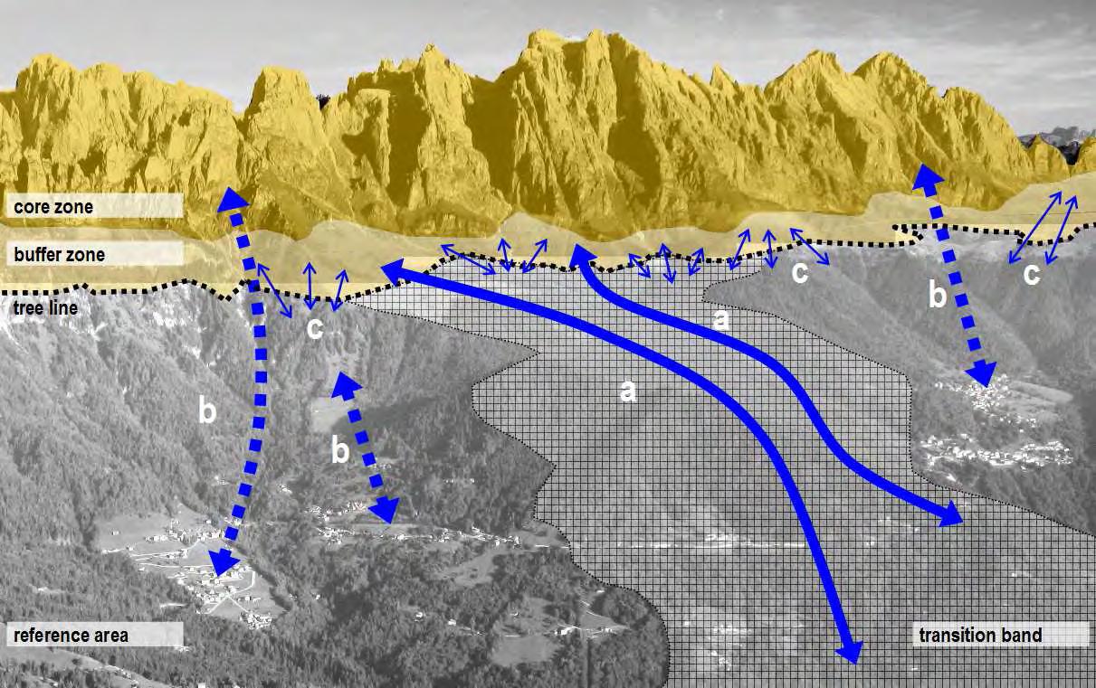
Connectivity actions transitionbandsandcontactpoints
To reduce fragmentation, it is necessary to identify continuous functional linkages (a) and discontinuous functional linkages (b)
To strengthen contact points (c) and transition bands, it is important to focus on ecotones, habitats and infrastructures (e.g. at the tree line).
[originally drawn up by © A²studio] promoting the eco-sustainable development of the Dolomites system: functional linkages also include immaterial links (cultural, historical, linguistic, etc.); functional linkages are central to the concept of sustainable development according the main ecological issues; eco-system services in the landscape are a useful tool for identifying transition bands; the ownership of the land is important when addressing issues such as planning and legal protection.
To promote eco-sustainable development and improve the connectivity capability of each c.s. (both core zones and buffer zones) with its surroundings, energies should be focused on the "interface line” which normally lies between 1600 and 1900 m/asl and often coincides with the tree line.
Similarly, it is important to boost the long-range connectivity capabilities between the different c.s., identifying the transition bands and promoting activities which are both compatible and desirable in the site.
From a practical viewpoint, consolidating connectivity involves: a) identifying compatible activities, looking beyond the traditional rural activities to include modern-day uses (e.g. outdoor recreation, slow tourism, slow trekking); b) involving the land owners when implementing the management objectives.
Interpretive model of the serial Property inrelationtoexistingplanningand/or managementtools.
[originally drawn up by © A²studio]
BUFFER ZONE type B tools
REFERENCE AREA type C tools type A tools existing planning and management tools, for example park plans, management plans for SACs and SPAs, programme agreements, etc.; type B tools primarily park plans, management plans for SACs and SPAs, combined with spatial planning tools, sector planning (forestry, rural, infrastructure, etc.) and local land planning type C tools exclusively spatial planning tools (regional territorial plans, provincial town urban planning, territorial coordination plans, etc.) which work in harmony with tools used in the planning of the wider area (inter-municipal town-planning schemes, community territorial plans, etc.).
The Dolomites WH is a complex site, not just because of its landscape and geology,butbecauseofthewayitisadministrated(differentset-ups:historical and cultural, land management, legislative and administrative, touristic, protectionofnature,transport,etc.).Forabetterunderstandingofthemodel,it isimportanttonotethat planning tools includeallformsofeconomicplanning (rural development plans, mobility plans, tourism plans, "snow plans", forest managementplans,etc.)andplanningoftheuseofthelandforsettlementand anthropicpurposes(regionalterritorialplans,provincialtownplanning,municipal and/or inter-municipal town-planning schemes, etc.), whereas management tools refertothecontrolofenvironmentaltransformationwithintheterritory(e.g. SCImanagementplans,parkplans,etc.).
Interpretive model of the serial Property inrelationtoexistingandpotential connectivityandbasedonanumberof macrofunctions.
[originally drawn up by © A²studio]
CORE ZONE to represent the OUV
BUFFER ZONE to protect the OUV
TRANSITION BANDS to manage and reduce pressure factors
REFERENCE AREA to implement connectivity and reduce fragmentation continuous functional connections phisical linkages discontinuous functional connections physical linkages the contact points between the c.s. and the surrounding territory; this interface is important to strengthen the landscape structure and the habitats network locally; continuous functional connections direct functional linkages between the different c.s.; they can be divided into existing (landscape, geology and geomorphology, eco-system) and potential (socio-economic synergies, institutional and administrative agreements etc.), in accordance with the OMS strategic actions; discontinuous functional connections conceptual connections (scientific, aesthetic-perceptive and touristicexperience) which should be structured or constructed in accordance with the objectives of the OMS. classificationoftheareas The operational model of the Dolomites serial site classifies the areas according to macro functions, namely: core zones, whose role is to represent the OUV; buffer zones, whose role is to protect the OUV; transition bands, whose role is to manage and reduce pressure factors; reference areas, whose role is to implement connectivity and reduce fragmentation between the c.s.. typeofconnections The proposed model defines connectivity, classified according to the methods of connection, as a structural element of seriality and a tool to help strengthen and/or protect the OUV. The topic linkages are: physical linkages, contact points between the c.s. and their immediate surroundings, where the connection is direct; interfacing with the surrounding territory is important to strengthen the landscape structure and the habitats network locally; continuous functional connections, direct functional linkages between the different c.s.; they are determined by the physical characteristics of the context and identified according to their type (e.g. landscape, geological and geomorphological, ecological, biological and habitat, socio-economic synergies, institutional and administrative agreements, etc.). The linkages may be existing and/or potential; discontinuous functional connections, indirect, “conceptual” linkages (scientific, aesthetic-perceptive and touristic-experience), which should be structured or constructed according to the objectives of the OMS.
Theinterpretivemodelcanhelpidentify–andthuscontrol–situationswhere potentially conflicting interests come into play. Generally speaking they are the transition bands between the different c.s. and the points of contact between the World Heritage and the areas around the Property subject to humanintervention(referencearea).ThemainentrancestothePropertyare concentrated in these interfacing areas (e.g.: Dolomite passes, cable car access, car parks at high altitude, etc.) which also play host to tourist and recreational activities and other initiatives involving the exploitation of the natural resources. All these activities exert pressure on the landscape, albeit in different ways, and so should be carefully assessed. In some cases extraordinary mediation and compensation procedures (e.g. to increase efficiency of the services in the areas where tourist flow is intense) or actual rehabilitationofthelandscapeandtheenvironmentarenecessary.
The distinguishing features of the core and buffer zones, which should be taken into account when drawing up the strategic guidelines, are: the presence and representative importance of the OUV; the conditions of the environment and nature; the degree and intensity of human intervention; the accessibility degree.
Adopting an adaptive and dynamic integrated model can therefore help meet the coordination and adaptive management objectives of the OMS of the Dolomites Property.
A model of this kind requires coherent contextualisation of the assessment methods applied to date and, consequently, indicators and standards must be chosen with the assessment of the effectiveness and efficiency of the management strategy in mind.
What follows is a dynamic, and not a deterministic, interpretation of the variable indicators and standards. As a result, the indicators standards relationship process goes from being iterative to interactive because as the "weight" of the indicators changes, so the thresholds have to “adapt”, a feature of a dynamic system. This is why it is important to select indicators which are also significant for the cultural, environmental, economic and social aspects, assessing the way in which these indicators can interrelate and represent alternative - or in some cases parallel - factors which can either boost or hamper development.
3 Adaptivemanagementtools
The Overall Management Strategy drawn up for the Dolomites UNESCO WHS is an example of an adaptive management model recommended by international assessment bodies (IUCN/WCPA) and is based on a specific procedure for evaluating management effectiveness 7 .
It requires long-term commitment as it involves periodical monitoring of the indicators, implementing management actions to maintain quality standards and correcting management practices in the light of the monitored data.
The management process is inclusive and participatory and conceived to control eco-sustainable development in densely populated mountain areas which are traditionally managed by the local communities. This is why it requires carefully planned and shared.
assessmentprocedure
The procedure to assess the management effectiveness of the Property is carried out using the best information available, collected through an iterative monitoring programme. Its objective is to check that the management practices are in line with the latest information and interpret the management objectives, indicators and quality standards as quantitative expressions of the limits of acceptable change (LAC).
The assessment process is divided into the following stages: application of the interpretive model, which represents the serial structure of the Property based on the characteristics of each c.s. and the quality of the connections between the various sites; confirmation of the classification of the areas based on the kind of activities and the planned intensity of use; assessment of the management and planning objectives referring to the classification of the areas; definition of some easily measurable performance indicators which are selected according to the management and planning objectives (the indicators for each area and use are determined with the involvement of the stakeholders); confirmation of the quality standards (desirable conditions and objectives to reach and/or maintain); application of the periodical monitoring schedule to measure the effects of the actions and the management measures; assessment and possible replanning of the management actions depending on the results. peerevaluation correct actions indicatorsandstandards Indicators measure the resources and phenomena at work in a system. Their aim is to provide information to help assess the context and guide the management of the system. The indicators for assessing the Dolomites context were determined using the Framework for assessing management effectiveness developed by IUCN WCPA 8 (Hockings et al. 2000). define objectives assess issues implement measures monitor results
To ensure the periodical assessment is objective and meets the standards required by inscription on the WHL, a continuous collaboration project with another World Heritage Site will be set up (WH peer evaluation). The peer WHS will be chosen after careful consideration of its organisation, structure and management to ensure comparison with the Dolomites WH is significant. The project involves periodical mutual assessment (on a 3-year basis), sharing experiences and field visits.
If the OMS is considered a cyclical and adaptive process, the themed issues focus on the natural, cultural and social values of the territory. The indicators, in turn, are to be considered taking into account the context of the Property as a whole or the individual c.s..
Generally speaking, indicators are selected according to whether they are: predictive: able to provide the information needed to assess the different stages in the management process; available: already entered in databases throughout the territory which are as uniform as possible; monitorable: periodically measurable according to homogeneous monitoring protocols; sustainable: obtainable from economically sustainable surveys.
The indicators selected are divided into quality indicators - describing the context before and after the scheduled actions - and performance indicators, monitoring the management processes.
The Quality indicators assess: the conservation status of the important values (mainly the OUV but not only); potential threats, pressures or risks; important, complex or controversial management problems.
Thesetsofindicatorsvaryaccordingto thezoningoftheinterpretivemodeland themanagementmacro-objectives.
CORE ZONE
BUFFER ZONE
TRANSITION BAND
REFERENCE AREA
The Performance indicators assess: policies and management priorities (in other words information which can be particularly useful in the decision-making process); results regarding development programmes and/or investments in collective management (area certifications, territorial agreements, MaB, reserve networks, etc.);
Indicatorsassesspressurefactors
indicatorsassessprotectionfactors indicatorsassesscompatibleuses,culturalvaluesandidentity indicatorsassessstructuralandinfrastructureset-upsandtheabilitytoincrease resources themes The indicators for each theme are selected according to the management objectives, the project situations (taking into account the experience of the area managers), experience in similar areas and following consultation with chosen stakeholders. themes key contents landscape and environment geomorphodiversity biodiversity integrity of the natural resources readability of the landscape units permanence and recognisability of the cultural matrices readability of the historical settlement presence of traditional activities management and planning control methods of the inhabited territory management methods of the uninhabited territory service and infrastructure planning methods (facilities and standards) mobility and transport society and economy prevalent economic sector "weight" of the prevalent sector compared to the other economic sectors definition of the economic “weight” of the individual activities in relation to the GDP of the valleys average income per capita degree of social wellbeing level of safety activities to enhance the local cultural heritage (material and immaterial) public and private investment in goods and services appeal of tourism and accommodation facilities running costs of protected areas running costs of connecting natural areas (not protected)
8 The aim of this framework is to help develop a system - and the related indicators - to assess the management effectiveness of the protected areas. This reference is based on a cyclical management approach where assessment focuses on both the processes and the effects, addressing issues connected with the context and planning, management systems and ongoing processes, accomplishment of the objectives (products and results). Each indicator selected is referred to the IUCN WCPA assessment matrix in order to build a comprehensive adaptive management framework.
Given the importance of tourism in the Dolomite area, a set of indicators has been drawn up which focuses exclusively on outdoor recreation and visitor experience and includes indicators which are transversal to the environmental, landscape, socio-economic, cultural and planning areas. This set of indicators conforms to the latest scientific findings on the subject 9 themes key contents outdoor recreation and visitor experience quantity and quality of accommodation quantity and quality of services quantity and quality of typical products (agricultural/food) quantity and type of infrastructures type and efficiency of public transport system (trains, buses) presence of infrastructures and sustainable mobility systems (cycle tracks, car sharing) number and quality of cultural events guided tour schedules specialised professional services offered advanced training for tourist operators professionalism of tourist operators organisation of promotional activities (no. of promotion agencies, promotion networks, cooperation between partners, etc.) environmental quality certifications
9 See. Siegrist D., Gessner S., 2013. Quality Standards for nature-based tourism in Protected Areas in the Alps. In: Nationalpark Hohe Tauern - Conference Volume 5: (2013): 5th Symposium Conference Volume for Research in Protected Areas, Mittersill, Salzburg, Austria,10-12 June.
CSR (Corporate Social Responsibility) and SCSRS (Sustainability and Corporate Social Responsibility Skills Certification) certifications monitoring programmes indicatorsset Below are lists of indicators taken from different sources: specialist literature, management authorities apps (parks, regions, provinces, municipalities), specific knowledge and experience (stakeholders). cultural habitat socio-economic aspects organisation of the geological structures and geomorphological processes map -hydrography of streams and rivers and surface and below water system water quality climate change (behaviour of glaciers and snowfields, change in the tree line, etc.) description -structuring of open spaces (meadows, lawns, regulation of woodland, etc.) map m² land ownership (collective, private, public ownership) map m² type of settlement (nucleus, scattered buildings, isolated buildings) level of permanence and recognisability of the historical and cultural settlement matrices perception of cultural values and identity (questionnaires, interviews) provenance (local, provincial, outside province, abroad) and type (single, family businesses, cooperatives, consortia, etc.) of economic descriptionmap no. description -- description -- description %
As far as The Dolomites WHS and its reference Alpine context are concerned, the set of indicators drawn up by the Alpine Convention was taken into consideration 10 .
These lists, although not complete, provide a useful tool when selecting the indicators for the assessment processes outlined in the individual operating plans. The contents pertaining to the key themes “heritage, community, system” are labelled in orange; the contents referring to the “experience” theme are in yellow.
10 See. Alpine Convention, Obiettivi ambientali nell’arco alpino e proposte di monitoraggio tramite indicatori. Rapporto conclusivo del Gruppo di Lavoro "Obiettivi di qualità ambientale specificamente alpini" della Convenzione delle Alpi (II mandato): http://www.umweltbundesamt.de/sites/default/files/medien/publikation/long/3143.pdf key contents indicator of data u.m. players provenance and type of economic resources and capital invested (public, private, mixed, banks, finance companies) description % economic weight of the activities and the sectors (transport, accommodation, professions typical of the mountains, restaurants, etc.) description -- description % willingness of the economic players to accept management protocols and share management responsibilities environmental protection (biotopes, SCIs, protected areas, etc.) map m² restrictions in town planning and use in the areas map m² land-use planning real use of the areas and relative surfaces (CORINE data) map m² building heritage number of existing properties (type, morphology, use, etc.) use of existing properties (degree of use, state of conservation, congruity, etc.) degree of technological facilities (electricity, drinking water, drainage system, municipal solid waste, etc.) description map no. description % description -- extension and efficiency of physical technological networks (electricity, drinking water, sewage, disposal of municipal solid waste, etc.) presence/absence of virtual networks (LAN, WIFI, etc.) extension of the footpath network (official and spontaneous) state of conservation of the footpath network (development into erosion - creeping channels) descriptionmap % description no. description lm description % extension of forest roads map lm use of forest roads (how accessed, frequency, etc.) networks mobility and rest systems (facilitated access services: cable systems, bus-shuttles; car parks: valley floor, at high altitude) accommodation accommodation facilities and quantification of performance (opening period, number of beds, seats/hour, meals/day, overnight accommodation,etc.) other facilities and classification (how used, frequency of use, etc.) permanent/seasonal employees working in the different activities flow management mobility of access and transport systems description % map description -- description no. description no./% description no. description -- interaction with systems on valley floor description -no. people using facilitated systems for reaching high altitude (shuttles, taxibuses and ski lifts) description no. first entrances (daily, monthly, seasonally) description no. key contents indicator type of data u.m. average wait for public transport description no. number of WCs/visitor description ratio people at one time description ratio tourist flow at high altitude description ratio no. of people using footpaths
Visitor Experience
description ratio signage for roads / trails for visitors (Besucherlenkung) description no. efficiency of footpaths description -damage to vegetation along the edges of the paths description -subsidence of soil due to walking description -creep damage (animals and people) description -quantification and assessment of the socioeconomic characteristics of visitors description -quantification and assessment of the behaviour of visitors perception of the quality of the visitor experience (crowding, quality of the services, perception of silence,..) perception of the landscape and aesthetic values (quality of the environment, possibility of spotting wild animals, ….) description -- description -- description -- waiting time in accommodation (for meals) description no. standardassessment The process for assessing standards is closely linked to the management objectives set out in the OMS. It involves the various stakeholders in the area - and in particular the management authoritiesand is the result of mediation between the project expectations and objectives.
When assessing the carrying capacity of a “closed” or static system, all the indicators are one-directional (they are neutral compared to the objectives) and express the capacity of the system to withstand perturbation (resilience).
In a dynamic and “open” system like the Dolomites, on the other hand, some indicators are two-directional, in other words they can be gauged to certain project objectives, becoming factors and expressing the capability of the system to be reorganised in order to deal with induced perturbation.
Each standard, namely the optimal reference value to associate with each indicator, is obtained through a process of assessment of the limits of acceptable change.
It is important to bear in mind that in a process of this kind, standards are not absolute values and that different standards will correspond to different situations. This is why an interpretive model of the Property has been used which is based on the functional classification of the areas.
