12 minute read
Time Traveler - St. Charles Co... from the Beginning


Time Traveler
By: Dorris Keeven-Franke
Advertisement
St. Charles is the earliest white settlement west of the Mississippi and north of the Missouri. As Captain William Clark notes, the place was first called Les Petites Côtes (the Little Hills). In 1787, Auguste Chouteau surveyed the settlement, and soon after the district of St. Charles was established. The parish church, and hence the settlement, was named for St. Charles Borromeo. To the Spanish it was San Carlos del Misuri. By the time of the Louisiana Purchase, the French inhabitants of the town were surrounded by American settlers in the countryside, including Daniel Boone and his family who had settled in the area in the late 1790s.
Contemporaries of Louis Blanchette (sometimes spelled Blanchet) stated that he and his wife, who he took from the Osage named Tichomchanga, and who later took the name Angelique had settled along a spring fed creek in 1769. At that time it was in Spanish territory that had been French, and in what was referred to as Illinois territory within the limits of the Spanish government’s holdings. The village was situated at the foot of a range of small hills, often referred to as La Mamelles sufficiently high to protect it from the summertime overflows of the Missouri.

The Census of 1787 of St. Charles… contains the following information about Blanchette “Juan Bapta Blanchet, aged 51; Maria Su Mujer; 48, Baptiste Blanchette 24; Maria Blanchette 21” In addition to these his household contained, one carpenter, one huntsman and four laborers. Houck also quotes Auguste Chouteau, as noted in Hunt’s Minutes Book 1, page 127 saying “les Petites Cotes was established by Blanchette.” Houck also established where Blanchette lived “the lot upon which the first house being the square now numbered 19 bounded on the south by McDonald [McDonough], west by Main, east by Missouri [River] and north by Water streets, and from this we infer that Blanchette must have first erected his hut on this block when he made a settlement at what is now St. Charles.” Historian Kate Gregg’s research stated: The first settler in St. Charles, and probably the first one to build a mill north of the Missouri was Louis Blanchette, who came to live at the foot of the river bluffs in 1769, and called them Les Petites Cotes or Little Hills. He established government buildings for the Spanish and a home for himself on what is now Block 20 of St. Charles; and on the stream that runs through it, the very water-course that the Boonslick [Boone’s Lick] Road later followed to the top of the hill, he established what appears to have been the first grist mill. Whatever hauling there may have been to and from his mill must have been, for the most part, between the mill and the village commons lying to the north of the town in the rich prairie; though there is every reason to believe that Blanchette and his neighbors made some kind of a road in getting from the southern part of the village where Blanchette lived, to the less fertile commons lying toward the west. The natural road between the mill and the two commons at the top of the hill was along the little stream which the Boonslick [Boone’s Lick] Road later followed.
In 1789, Louis Blanchette, sold his land in the southern part of the village to John Coontz, a German,... and he too erected a grist mill
on Blanchette Creek, building a dam for it on what is now known as Block 79. Romain Dufreine, testifiying before Theodore Hunt, Land Commissioner, on May 7, 1825, swore that John Coontz had built his mill on this square thirty years before, i. e., in 1795, and had continued to occupy the land until he moved to the Dardenne ten or twelve years later.
In 1787 the population was said to be eighty families to one hundred families. “The houses, about one hundred in number, in which the four hundred fifty inhabitants lived, were scattered along a single street about one mile long”. Even though ‘les Petite Côtes’ (the Little Hills), or San Carlos (Saint Charles) belonged to the Spanish, its inhabitants were mainly French- Canadians. Their occupations were fur trappers, traders and boatmen. They interacted with the Native Americans on a daily basis, intermarried with them, and their cultures combined not clashed. Outsiders considered them poor and indolent, but those that visited and got to know them insisted this was not true. It must have been a picturesque early settlement along the riverfront with the hillsides behind them rising and creating a backdrop for the early log houses, built in the early French style.
The 1800s
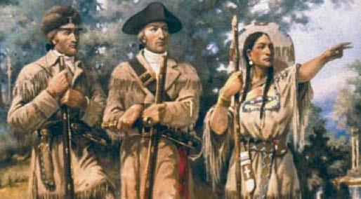
In 1804, America was excited to know what lay out there past the Mississippi in that new purchase called the Louisiana Territory. President Thomas Jefferson would appoint his Secretary Meriwether Lewis to lead an expedition with an assignment to find a passage to the Pacific Ocean, thinking the Missouri River would take them there. Lewis chose his friend William Clark to accompany him. Since the final word on the purchase had not reached the Spanish Commandant, the Corps of Discovery was not allowed passage across the Mississippi River, and would be forced to spend the winter of 180304 in preparations on the Illinois side of the river. From the Journal of Joseph Whitehouse, a member of the Lewis and Clark Expedition in May of 1804. Wednesday the 16th We set out this morning, having clear weather, and proceeded on very well, about 2 o’clock pm we arrived at Saint Charles, where we passed the Evening with a great deal of satisfaction, and chearfulness, and all our men appeared to be in good spirits.

“We shall waite here for Captain Lewis, who is to meet us from Saint Louis. Saint Charles is a Village settled by French Inhabitants. It is a handsome situation, laying on the North side of the River contains about 80 Houses, built in the french fashion, and has a small Roman Catholic Chapel. its Inhabitants are chiefly canadian french; who are chiefly concerned & employed by others Trading with the Indians who reside on the River Mesouri, and other Rivers that empty into it. The land adjoining it appear to be hilly, but the soil is good and fitting for Agriculture.—Saint Charles lies in Latitude 38° 54’ 39 North & 19 Miles from the Mouth of the Mesouri River” Because of discrepancies in the records and journals, especially concerning the French boatmen, it is difficult to determine exactly the number of men who left River Dubois with Clark. George Drouillard was absent on an errand and may not be the Frenchman singled out by Clark; possibly he was Baptiste Deschamps, the patroon (foreman) of the hired French boatmen, although later he seems to have been in charge of a pirogue..
The exact number and names of the French boatmen remain unclear throughout (see Appendix A). Clark may not have counted York, his personal servant, in his total. Among those leaving Wood River, besides Clark and York, were twenty-five members of the permanent party, as then planned, who were to make the full trip to the Pacific: Sergeants Floyd, Ordway, and Pryor, and Privates Bratton, Collins, Colter, Reubin and Joseph Field, Gass, Gibson, Goodrich, Hall, Howard, McNeal, Newman, Potts, Reed, Shannon, Shields, Thompson, Werner, Whitehouse, Willard, Windsor, and Weiser. Corporal Richard Warfington’s detachment, who were to return from some point up the Missouri with dispatches, then included Privates Boley, Dame, Frazer, Tuttle, and White. Private John Robertson (Robinson) may also have been present at this time; perhaps he was one of the six soldiers in a pirogue—probably Warfington’s squad.
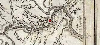
St. Charles location on the map by James Mackay used for the Lewis and Clark Expedition of 1804
The enlisted men’s journals all state that there were three sergeants and thirty-eight “working hands”; whether York (An African American enslaved person owned by William Clark) counted as a working hand is not clear. If one counts twenty-five in the permanent party and seven men in Warfington’s detachment, nine French boatmen are necessary for the three sergeants and thirty-eight hands. Adding York, one has forty-two men leaving River Dubois with Clark. Other Frenchmen may have been hired at St. Charles, notably Pierre Cruzatte and François Labiche, who became members of the permanent party. Appleman (LC), 367 n. 64. (back)
The Corps would await Meriwether Lewis who was in St. Louis attending to some business. Everyone would enjoy themselves for one last time in the village, waiting for the expedition to begin. St. Charles Missouri is celebrating its 250th birthday in 2019. In St. Charles visit the Lewis and Clark Boathouse for an excellent museum that shares the story of the Lewis and Clark Expedition, and houses reproductions of the Keelboat and the white and red pirogues. (For more information see http://lewisandclarktradingpost.org )

By 1808, the Village is of such importance that the U.S. Government would send its U.S. Army to establish Fort Osage, as Sibley and Clark assembled their men here, they would leave on an established road, formerly called the Osage trace (a well traveled road) that left from in front of the former Blanchette’s house. On July 8, 1808 the U.S. Government, from their headquarters at St. Louis at that time had made laws that established roads, and the local village had begun to petition for a road to the west. The small village had grown to become a young City, westward expansion had begun, and on October 10, 1809, the City of St. Charles was Incorporated so that it was able to establish its own laws, survey and sell its land, and govern the village which had grown to nearly a thousand people already.
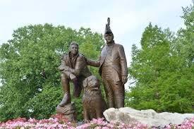
Statue of William Clark, Meriwether Lewis and Seaman the dog hat accompanied the Corps to the Pacific. Located in City of St. Charles Riverfront Park. The Incorporation papers, found in the City of St. Charles Record Book A Page 6 say: “Saint Charles Eighteen Hundred and nine… At a Court of Common Pleas began and held at the village of Saint Charles for the District of St. Charles on Monday the thirteenth day of October in the Year of our Lord one Thousand and Eight Hundred and nine and of the Independence of the United States the thirty fourth.
Signed, Presnt the Hon. Timothy Kibby James Flaugherty Francis Saucier and Robert Spencer
In the record and proceedings of said Court we the following viz. “In conveyence of the Petition of two thirds of the inhabitants of the village and commons of Saint Charles praying the said village may be incorporated. The Court finding then petition to be completely comporting with the laws of this Territory in such laws made and provided have therefore granted the said petition and have accordingly appointed Alexander McNair and Doctor Reynolds Commissioners and that a plat of said village and commons be filed in the Clerks off of this court.” Wm Christy for Clerk

The War of 1812 began with President Jefferson’s purchase of the Louisiana Territory in 1804. Westward expansion, Manifest Destiny, Louisiana Purchase are the same. Quite a deal had been cut because France needed the money. Saint Charles territory stretched northwest of the Missouri River to uncharted lands. After the Corps of Discovery departed that May, the Territory’s trickle of settlement began. We were far outnumbered though, by the Indian tribes as the Territory contained nearly the entire domain of the Sauk and Fox. We lived with the constant fear of attack.
When Sauk and Fox killed several settlers north of Saint Charles, they turned over one of the warriors involved in the incident, with a petition for pardon to Governor Harrison. The result was a Treaty, in 1804, that read,“As long as the lands that are now ceded to the U.S. remain their property, the Indians belonging to the said tribes shall enjoy the privilege of hunting on them.” Some questioned whether the U.S. even really had the right to Treaty as the acquisition was so freshly inked. The land involved included today’s Saint Charles County.
By 1812, we did not know that our young country had just officially gone to war for the first time, with President Madison’s signature. They were totally unaware that the House of Representatives had hotly debated the issue, behind closed doors, ending with the closest vote for war in our Nation’s entire history. For most of the United States, this war would be over the issues of trade embargoes and the capture and forced service of over 10,000 of our men into their British Navy. But for those living here on the frontier, it was the Indian War, and we had been fighting it here for years. The British used the Indian tribes, inciting them to harass and slaughter, because of our expansionist activities. Britain was involved in a fierce struggle with Napoleon in Europe. Our pride would not allow us to ignore these threats to our national honor, that most viewed as a continuation of our war for Independence.

By 1815, the United States would treaty with all tribes, at Portage des Sioux along the Mississippi, including the Osage. “A treaty of peace and friendship, made and concluded between William Clark, Ninian Edwards, and Auguste Chouteau, Commissioners Plenipotentiary of the United States of America, on the part and behalf of the said States, of the one part; and the undersigned King, Chiefs, and Warriors, of the Great and Little Osage Tribes or Nations, on the part and behalf of their said Tribes or Nations, of the other part.”
Auguste Chouteau made the first survey of the village, under order of the Spanish authorities, but the map of the village, has not been preserved, according to Gabriel La Trail, one of the oldest residents of St. Charles in 1824, who said “he assisted in the survey”. He was one of the principal witnesses before Commissioner Hunt testifying as to the ownership and occupancy of many of the lots of the village. Another who helped with the survey was Louis Barrada the Senior.


