
12 minute read
Outdoor & Recreation


Watauga Lake
The local name of the Watauga Reservoir created by the Tennessee Valley Authority with the 1948 completion of the Watauga Dam. Fed by the Watauga and Elk Rivers, the lake has an average depth of 52 feet, and covers 10 square miles of a valley that was once the town of Butler, Tennessee. It is stocked by the Tennessee Wildlife Resources Administration with Walleye, Rainbow Trout, Largemouth Bass, Bluegill and more. The Cherokee National Forest surrounds Watauga Lake in some of the most beautiful country in the Tennessee River watershed. The original town of Butler, Tennessee, now sits at the bottom of Watauga Lake.“New” Butler was relocated to higher ground above the summer pool edge of the TVA reservoir. According to lake expert Holly C Ward, Watauga Lake is the third cleanest in the country. More than half of Watauga Lake’s shoreline lies within the Cherokee National Forest and cannot be developed. Recreational uses include boating, fishing, water-skiing, and camping. There is no horse-power limit or speed limit for boats operating on the lake. Several fee-based public and private boat launch ramps provide access on the Hampton side of the reservoir. The release of impounded water from both TVA Watauga Dam and TVA Wilbur Dam provides additional downstream river recreational opportunities such as whitewater rafting, trout fishing, and kayaking on the Watauga River, and several Cherokee National Forest recreation areas are located along its shores.
Advertisement

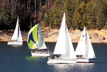
Frost Bite Race
Sail boat enthusiasts hit Watauga Lake on New Year’s Day to take part in the Frost Bite Sail Boat Race, which takes it name from the frigid conditions that can sometimes be expected on the lake at that time of year.
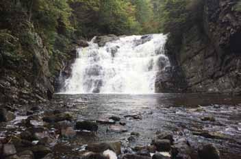
Laurel Falls
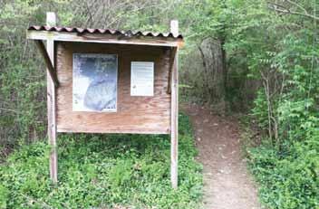
Located along the Appalachian Trail between Hampton and Dennis Cove. Also known as Laurel Fork Falls, it is a fairly large waterfall in a deep gorge. It can be reached from the trail head in Dennis Cove or from the Laurel Falls trail head in Hampton, located along Laurel Fork on Highway 321. The Hampton trail merges with the Appalachian Trail, which splits off over the mountain toward Watauga Lake. Parts of the trail running along Laurel Fork lie on an old narrow gauge railroad bed. In places there are two parallel trails. The blue blazes indicate the alternate high water trail. The trail from Dennis Cove is shorter and mostly level except for a couple places, like the descent down to the falls. The Hampton trail is much longer, mostly level with a few climbs. It takes about an hour of walking to reach Laurel Falls from Hampton but it is a nice hike.
Jones Falls
A high waterfall with a small stream, Jones Branch runs on to the Elk River near the state line after tumbling through this waterfall. It’s located near the Appalachian Trail close to the Buck Mountain area of Carter County. A side trail goes to the falls from the Appalachian Trail. The coordinates for Jones Falls are N36.20290° W81.98234°.

Dennis Cove
Located in Hampton, the Dennis Cove Recreation area is a campground and picnic area nestled beside Laurel Fork Creek. The secluded campground is ideal for camping during the summer months due its altitude and forest surroundings. With 15 campsites, Dennis Cove is a great option for a group to reserve the whole campground for retreats and other events. Along with camping, Laurel Fork Creek is stocked with rainbow trout below the campground.
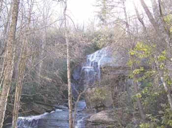
A series of four waterfalls located on Holston Mountain in the Stoney Creek community of Carter County. The falls’ name, Blue Hole Falls, comes from the deep blue pool in front of the third waterfall, which is the main fall in the series. Nestled in the crags of Holston Mountain, the Blue Hole Falls are a treasure waiting to be found.
To travel to the Blue Hole, take Highway 91 north through Stoney Creek and turn onto Panhandle Road. Shortly after the pavement turns into a gravel Forest Service road there is a small parking area on the left. Follow the trail down the hill to the falls. The hike is steep in some places so be prepared. This is a popular local gathering spot in the summer.
The main falls at The Blue Hole
Watauga Dam Campground
Located in Carter County, the Watauga Dam Campground is located on the Watauga River far from heavy vehicle traffic. The campground has 29 RV sites, some located right on the river making it perfect for fishing trips.
Watershed Bike Trails
Ranging from easy to difficult, the Watershed Bike Trails in Hampton are perfect for riders of any skill level. The bottom loops are ideal for novice and intermediate riders, while more seasoned riders can hit the challenging upper loop known as The Cat’s Pajamas. The trails cut through forests that open to beautiful river and mountain views.
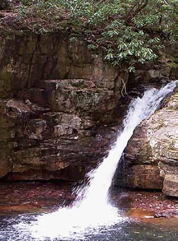
Coon Den Falls
Known by some in the past as Bear Cave Falls. This is a very high solid rock wall with a minimal stream coming off the edge. It is reached by hiking from Dennis Cove. The trail is easily missed, located along the road between the National Forest campground and the Appalachian Trail/ Laurel Falls trail head. It is .6 miles from the trail head near a private property boundary. Laurel Fork runs along the road at this point. The slope up to the falls is moderate. In the winter the tall rock face becomes a wall of ice.
Boasting 40 sites, Cardens Bluff Campground looks out over Watauga Lake. Opportunities for swimming, fishing, and boating in the pristine waters of the Watauga Lake are located nearby. Access to the campground is located right off of Highway 321 in Carter County.

Twisting Falls
Located in one of the more remote areas of Carter County past Nowhere Ridge. That’s right-these falls are beyond nowhere, which isn’t far from the Avery County North Carolina line on the Elk River near the Poga community. It’s reached by taking Poga Road off 321 in the Elk Mills area, to Clawson Road, then to Dark Ridge Road. Park near a barn and then walk a slow steep grade to the falls. There have been a number of injuries at this popular destination for locals and out of town visitors, so be careful!
Ripshin Lake
A much smaller nearby lake that is not part of the TVA system is located 6 mi (9.7 km) SW of Roan Mountain. Although this is not the place for a family outing or a picnic, it is a wonderful place to drive through and admire the scenery. This peaceful but restricted area is almost completely privately owned land and is patrolled periodically by local owners. However, a main road passes within just a few feet of the lake and especially in the fall of the year, lends itself to some incredible photo opportunities. The road parallels “Roaring Creek” which is a beautiful mountain stream that winds down the mountain with one small waterfall after another. The creek cannot be seen in the summer due to the foliage but when the leaves fall, the views are spectacular.
Waterfalls of Laurel Fork
Forest Service Trail 39 runs along the mountain stream water of Laurel Fork above the campground in Dennis Cove. Special trout regulations apply to this section of Laurel Fork above Dennis Cove. The trail head is along the bridge right before the Forest Service campground. It involves several crossings of the creek before reaching these beautiful waterfalls with large splash pools. You reach a single fall first, then a short distance up the trail is a triple cascade. Above these falls the trail runs on to Frog Level. Frog Level is a relatively flat area of land set deep in the mountains. It’s another special place. The change in topography to flatness seems odd. The stream becomes calmer and more like a lowland creek. It’s the opposite of what might be expected from ascending a mountain stream.
The Appalachian Trail... and Roan Mountain, an Appalachian Trail Community
Opportunities for hiking in Carter County are numerous and varied with something for hikers of every skill level and interest. For the more avid hikers, the famed Appalachian Trail passes through the county with a number of landmarks, shelters, hostels, and incredible sights to see.
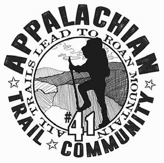
The Appalachian Trail runs the length of the county. Some of the best scenery on the trail is found right here. The trail crosses Round Bald on the Roan Mountain, Yellow Mountain, Hump Mountain, then crosses Hwy 19E near the TennesseeNorth Carolina state line. It climbs and then follows the ridge of the aptly named White Rock Mountain while traversing some of the most remote areas in the county. The trail descends into Dennis Cove, past Laurel Falls and then across Hwy 321 at the Shook Branch Recreation Area on Watauga Lake. Then it winds around the west end of Watauga Lake, crosses Watauga Dam and heads up the length of Iron Mountain. Numerous other trails connect to the AT and it’s easy to miss the many forks along the way. The white blazes on trees and rocks mark the AT way. Two blazes indicate a fork in the trail. In 2017, the village of Roan Mountain was designated as the 41st “Appalachian Trail Community” by the Appalachian Trail Conservancy. The designation marks Roan Mountain as a hiker-friendly community along the trail where hikers can stop to rest and re-supply. Being an Appalachian Trail Community also helps the town market itself to hikers who will be traveling through the area.
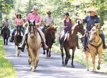
Horseback Riding
The Hinkle Branch Trailhead leads to 36 miles of interconnected trails (old road beds, single track trails, and Forest Service gated roads). Large, easily accessible parking lot. Directions: Elizabethton, TN off Highway 91. Heading away from Elizabethton the trailhead is just past Unaka Elementary School. Look for the large brown Forest Service trailhead sign on your left. Other trails include a six-mile long gated road with approximately two miles of singletrack connector trail. Parking for about five trucks and trailers is available. There is also a connector to the Little Stoney Creek Jeep Trail (ca. 3 miles long).Directions: From Elizabethton, take Highway 91 towards Stoney Creek, look for the large brown Forest Service sign which directs you to turn left onto Rainbow Circle.


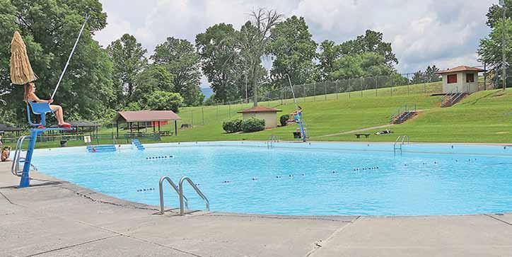
Joe LaPorte Recreation Facility
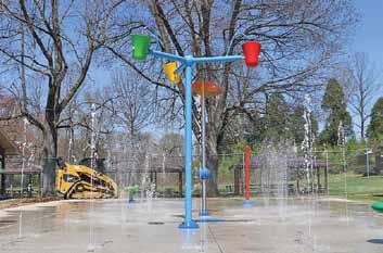

The City of Elizabethton’s Joe LaPorte Recreation Facility is a 3.9-acre facility that is home to the Olympicsize Franklin Pool, acres of grass area for lounging and two covered pavilions inside a gated facility. Franklin Pool features two diving boards with the pool and a newlyconstructed splash pad. The pool opens Memorial Day weekend and closes in the fall. Pavilions are for rent by contacting the Parks & Rec department.
The public can take in the sheer beauty of Elizabethton by walking the Elizabethton Linear Path. The roughly sixmile path spans from East Side Elementary to Sycamore Shoals State Historic Area. The Linear Path follows the scenic Doe River through the heart of Elizabethton and follows the Watauga River westward downstream to the historic area. The path features great fishing spots, bike racks, picnic tables and benches.
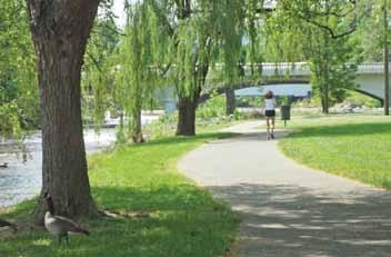
Elizabethton Linear Path
Elizabethton Golf Course
A treasure for any sports enthusiast is the Elizabethton Golf Course.
Located on Buck Van Huss Drive near the west end of the City of Elizabethton, the 18-hole, par 72 course, spanning 6,470 yards allows patrons to experience the natural beauty of the community while fulfilling every golfing need. The facility, owned by the City of Elizabethton and operated by Hampton Golf, offers a variety of needs for any golfer. Elizabethton Golf Course offers a fully-stocked Pro Shop, practice amenities, The Cookhouse Restaurant and regularly serves as a hub for various fundraising activities within the region.


A rail-trail that follows the former ET&WNC (“Tweetsie”) Railroad rightof-way for 9.5 miles. It begins at Alabama Street in Johnson City and continues east through Elizabethton and the city’s downtown. It ends on Stateline Road near the Betsytowne Shopping Center. The trail has a compacted stone surface, a relatively flat grade, and crosses seven bridges. Along the way, travelers can rest and enjoy its beautiful, natural surroundings on several benches. A “trail extension” stretching all the way to Roan Mountain carries on from the end of the “Tweetsie” at Hatcher Lane in Elizabethton. Parking is available in Johnson City at the Memorial Park Community Center, Cardinal Park, and the Municipal and Safety Building (City Hall). In Elizabethton, parking is available at Elizabethton High School.

The glory days of the railroad in Carter County and Elizabethton are told through the stories of the North American Rayon Steam Engine, the Tweetsie boxcar, and a caboose from the Southern Railway. The ET & WNC Railroad (Tweetsie) operated in Elizabethton from 1881-1951; the Southern from 1911-1940 ; and the NAR Steam Engine from 1936-1992.
The Elizabethton/Carter County Historic Train Display is a tangible reminder of an era when the railroad played a prominent role in the economic development of the community -when lumbering, mining, and rayon were vital industries.


