Archaeological Desk-Based Assessment (DBA) Corran Point Battery, Carrig Island, Ballylongford, County Kerry Diarmaid Walshe BBS (Hons), MA(Arch), PCGE
Ethos Heritage CIC
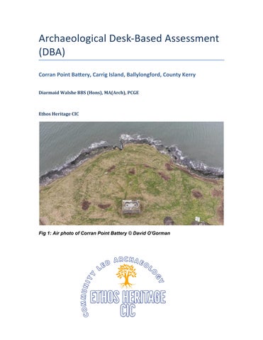
Fig 1: Air photo of Corran Point Battery © David O'Gorman
1. Executive Summary 1.1 Corran Point Battery (Fig 1) is a Napoleonic-era coastal artillery fortification constructed between 1809–1814 as part of the Shannon Estuary defence network. Its purpose was to prevent hostile naval forces from entering the upper estuary and threatening Limerick. One of six batteries (Kilcredaun CL072-027002-, Doonaha CL066037001-, Scattery Island CL067-024015-, Kilkerin CL068-046---- and Tarbert KE003002----) proposed by the Gother Mann Committee as part of the fortification of the Shannon estuary (McEnery 2006, 104). 1.2 In 1806 Gother Mann, Inspector-General of fortifications, proposed rough costings for artillery fortifications of the Shannon estuary which included Carrig Island Battery and tower (Fig 2) which he estimated would cost £6,000(McEnery 2006, 76) or £700,000 in 2026 (Walshe pers coms 2026) 1.3 In 1810 the Board of Ordnance approved estimates for the construction of the six artillery fortifications (ibib.). The contract was awarded to Mr. Flattery who excavated the trenches but failed to construct the masonry elements which were awarded to Mr Quillan a second contractor who commenced work on these fortifications in 1812 (ibid.). 1.4 On August 2nd, 1814, master gunners were posted to these batteries including Robert Kinnerbury to Carrig Island battery (ibid., 106). The Master Gunners House is depicted on the 1841 ed. OSi 6-inch map where it is shown standing c. 80m E of the tower of the battery.
Fig 2: A reconstruction of a typical Shannon type Battery © Paul M. Kerrigan 1.5 In 1817, Carrig Island tower and battery was recorded as possessing six 24-pound guns and two 5.5-inch howitzers (ibid., 80). 1.6 Around the year 1868 the six 24-pound guns at Carrig Island were replaced by more powerful 68-pound smooth bore guns (ibid., 137, 144). According to McEnery (2006, 134, 143) in 1891 the gunners abandoned the Napoleonic defences of Carrig Island Fort.
1.7 The battery defended the River Shannon with guns mounted on the curving N side of the earthwork as shown on the ground plan of Carrig Island Battery. The slot trench of the curving stonework which carried the guns allowing them to move is still visible. 1.8 The bombproof rectangular-shaped tower (Blockhouse) (Fig 3 leftCurran Point Napoleonic Tower and Battery © David O'Gorman) of the battery was constructed of dressed stone and supported two howitzers or a short cannon used to fire projectiles with relatively high trajectories. The North side measures 16.3m in length, It displays a semi-circular headed dressed doorway which has two pulleys attached, possibly to draw up the door. It also displays four small rectangular windows which measures 0.9m in length. 1.9 The south side has no windows or doorway but, in the interior, running along the wall from the first floor to the roof is a stairway. The eastern side measures 9.85m in length and displays one large window and two small rectangular ones. The western side also has one large window and four small rectangular ones. 1.10 Corran Point Battery described by Kerrigan (1995, 210-11) as follows; 'This battery commanded the southern part of the channel between Carrig Island and Scattery Island, a distance of about two miles, so that the passage of the river here was commanded by the two batteries. 1.11 The moat and ramparts of the Corran Point battery have almost disappeared, the removal of the stonework causing the gradual collapse of the scarp and counterscarp. As stated the Tower or Blockhouse remains, the doorway having been altered and extended in recent years to form an opening at ground level. 1.12 The gun platform at roof level (Fig 4) with its positions for two guns is approached from the upper floor level by a staircase built within the wall thickness, as at Kilkerin [CL068-046----]. The inner face of the parapet and the banquette are constructed of regular ashlar masonry, the banquette having a shallow groove in the stonework for the iron rail of the traversing mount for each gun.
Fig 4: Gun positions on the roof showing the access door © David O'Gorman 1.13 The structure has the usual battered-wall surfaces, constructed of squared rubble built to courses with regular masonry at the quoins and at the door, window and musketloop openings. 1,14. Plans indicate that the battery had the same layout as the other Shannon batteries (Fig 5), the curved front of the battery having the inner face of the parapet indented at each gun position, as at Kilkerin. Lewis, in his Topographical Dictionary of Ireland, described the work as a battery and bombproof barrack (Blockhouse or Tower) for twenty men; by 1837 it had become a coastguard station'.
Fig 5; Typical plan of a Shannon Battery © Clare Co Council 1.5 Today, the battery survives as a ruin with significant structural collapse, stone robbing, and agricultural reuse, but retains high archaeological potential. 2. Introduction & Scope 2.1 This DBA assesses the historical, architectural, and archaeological significance of Corran Point Battery, drawing on historic OS maps, aerial photographs, military records, antiquarian sources, field observations, and local knowledge. It includes a full map regression, architectural analysis, condition survey, and recommendations for conservation and further investigation.
3. Methodology (Expanded) The assessment of Corran Point Battery has been undertaken using a multi-disciplinary, non-intrusive methodology designed to integrate historical, cartographic, architectural, and landscape evidence. The following approaches were employed: 3.1 Review of Historic Cartography (1830s–Present) A full map regression analysis was carried out using Ordnance Survey maps from the early nineteenth century to the present day. This allowed for the identification of structures no longer visible above ground such as the Master Gunner’s House, shot furnace, and internal buildings and provided insight into changes in the battery’s layout, boundary definition, and surrounding landscape over time. Comparison of successive editions also helped to track the progression of stone robbing, collapse, and saltmarsh encroachment. 3.2 Analysis of Aerial Photographs and Satellite Imagery Historic and modern aerial imagery was examined to identify earthworks, soilmarks, vegetation patterns, and structural footprints not easily visible at ground level. This analysis highlighted the outline of the parapet, the partially infilled moat, collapsed masonry zones, and environmental processes such as coastal erosion. Satellite imagery provided additional data on seasonal vegetation change and long-term landscape evolution.
Fig 6. Air Photo (2013) of Corran Point © Tailte Éireann
Ethos Heritage carried out in early August 2026 drone mapping of the battery which provided a unique overview of the site. A new discovery was the man-made alteration at the front of the battery where the guns were positioned. Further analysis is required but it appears that this opening may have been caused by blasting to create a landing point at the front of the battery. This would allow personal and provisions to be brought directly into the site which apart from this has no natural landing point close by. Link to 3D model of the battery: Battery 3D model
3.3 Review of Military Engineering Manuals and Artillery Records Contemporary military manuals, artillery specifications, and War Department documents accessed at the UK National Archives at Kew as well at the National Amouries, Leeds were consulted. This was done to understand the original design, armament, and operational function of the battery. These sources informed the interpretation of gun positions, traversing platforms, carronade mounts, and the internal arrangement of the blockhouse and ancillary structures. They also provided context for the battery’s role within the wider Shannon Estuary defense network. 3.4 Examination of Heritage Inventories and Archival Sources National and regional heritage databases, archaeological inventories, and archival collections were reviewed to identify previous surveys, recorded monuments, and any documented interventions at the site. This ensured that the assessment incorporated existing knowledge and aligned with statutory designations and conservation frameworks. 3.5 Structural Interpretation Based on Surviving Remains A detailed visual inspection of the extant masonry, earthworks, and architectural features was undertaken to interpret the construction methods, phasing, and condition of the battery. Surviving elements such as embrasures, traversing grooves, wall thicknesses, and collapsed floor structures were analysed to reconstruct the original layout and defensive capabilities of the site. 3.6 Landscape Analysis The wider landscape setting was assessed to understand the battery’s strategic placement, intervisibility with other Shannon defenses, and its relationship to natural features such as the tidal channel, saltmarsh, and coastal edge. This analysis also considered environmental pressures—including erosion, flooding, and vegetation encroachment—that currently threaten the integrity of the monument.
4. Site Location, Geology & Topography 4.1 The battery occupies the western tip of Carrig Island, positioned directly above the narrow southern channel of the Shannon Estuary where the tidal flow constricts into a natural maritime chokepoint. From this vantage, the site commands an uninterrupted field of fire across the channel, forcing all vessels entering or leaving the estuary to pass close to the shoreline and within effective range of the battery’s long guns and carronades. Its placement reflects deliberate military engineering: the western promontory provides both elevation and control over the deepest navigable water. 4.2 The underlying geology consists primarily of glacial till overlain by estuarine silts and clays, typical of low-lying coastal platforms in the Shannon region. These deposits create a relatively soft substrate that is prone to erosion, slumping, and waterlogging. The landward approach is increasingly affected by saltmarsh encroachment, with halophytic vegetation advancing toward the battery as sediment accumulates in the sheltered inner estuary. This process is gradually narrowing the dry access corridor and altering the historic landscape setting of the monument. 4.3 Topographically, the battery sits between 2–4 metres above present sea level, providing modest but strategically sufficient elevation for artillery deployment. The highest point on Carrig Island rises to approximately 6 metres above sea level, meaning the battery occupies one of the island’s most advantageous positions for visibility, defence, and communication with other Shannon fortifications. Its low but commanding platform allowed for clear intervisibility with neighbouring defensive sites, including Tarbert, Kilkerin, and Scattery Island, forming part of a coordinated estuarine defence network. 4.4 Overall, the location combines strategic military value, geomorphological vulnerability, and landscape significance, making it a key site for both historical interpretation and ongoing conservation planning.
5. Historical & Archaeological Background 5.1 Strategic Purpose Corran Point Battery was deliberately positioned to command and control the southern navigation channel of the Shannon Estuary, the route through which the majority of deep-draught vessels were required to pass. From this location, the battery could deliver sustained, accurate fire on any ship attempting to enter the estuary, effectively creating a controlled maritime chokepoint. Its placement also enabled overlapping and mutually reinforcing fields of fire with the neighbouring batteries at Tarbert and Kilkerin, forming a coordinated defensive network designed to prevent hostile vessels from bypassing the main fortifications. Together, these sites created a layered system of long-range and close-range artillery coverage that denied enemy ships the ability to exploit alternative channels or approach Limerick undetected. By dominating the narrowest and most navigationally constrained section of the estuary, Corran Point Battery played a critical role in protecting the approaches to Limerick, safeguarding maritime trade, and ensuring that any hostile fleet would be forced to run a gauntlet of interlocking fire before reaching the upper estuary. 5.2 Construction (1809–1814) Corran Point Battery conforms closely to the standardised Shannon Estuary coastal-defence design developed by the Board of Ordnance in the late eighteenth and early nineteenth centuries. The layout centres on a D-shaped gun platform, its curved seaward face designed to maximise the arc of fire for the six long-barrel 24-pounder guns. This platform is enclosed on the landward side by a dry moat, originally 3–4 metres wide, which formed the first line of defence against infantry assault. Access to the battery was controlled by a drawbridge entrance, allowing the garrison to isolate the position in the event of attack. At the core of the complex stands the defensible blockhouse, a two-storey, thick-walled structure providing both accommodation and a final strongpoint. The blockhouse was constructed with bombproof internal spaces, including vaulted ceilings and reinforced masonry intended to withstand artillery fire. An internal staircase linked the ground floor to the roof platform, where two carronades were mounted to deliver devastating close-range fire. Supporting structures formed an integral part of the battery’s operational function. The Master Gunner’s House provided dedicated accommodation for the senior artillery specialist responsible for maintaining the guns, ammunition, and firing equipment. Additional garrison accommodation and service spaces—now lost or buried—once stood within the enclosure, as shown on early Ordnance Survey mapping.
A key feature of the Shannon batteries was the inclusion of a shot furnace, located near the center of the enclosure. This brick-lined furnace was used to heat solid iron shot to a red-hot state before firing, enabling the garrison to ignite the hulls and rigging of wooden ships attempting to force the channel. The presence of a shot furnace underscores the battery’s role in active coastal denial, providing the capability to inflict catastrophic damage on hostile vessels at close range. Together, these elements reflect a highly standardised and strategically coherent defensive system, purpose-built to control the narrow southern channel of the Shannon Estuary and to operate in concert with the neighbouring batteries at Tarbert and Kilkerin. 6. Armament: Six Long-Barrel 24 or 68-Pounder and two 5.5 Howzerers 6.1 The 24-Pounders Smooth Bore Guns Corran Point Battery was originally equipped with six long-barrel 24-pounder guns, the principal heavy artillery pieces used throughout the Shannon Estuary defence network. Each gun measured approximately 9 feet in barrel length and weighed between 50–60 cwt, making them substantial weapons capable of delivering sustained, long-range fire. Their effective range of 1.5–2 km allowed the battery to dominate the narrow southern channel between Carrig Island and Scattery Island, forcing any vessel entering the estuary to pass within their field of fire. (Fig 7)
Fig 7. 24 Pounder on its traversing its carriage and traversing platform © Romney Marsh History Society
These guns fired a variety of ammunition types, including solid round shot for hull-breaching, canister for anti-personnel defence, and heated shot intended to ignite wooden ships. The guns were mounted on iron-railed traversing platforms, (Fig 7) enabling rapid lateral movement and precise targeting. Their arrangement along the parapet created overlapping and mutually supporting arcs of fire, ensuring that no vessel could approach the channel without being exposed to multiple guns simultaneously. 6.1 The 68-Pounders Smooth Bore Guns In 1868 the 24 pounder guns were replaced by the 68-pounder (8.12-inch bore) was renowned as the finest smoothbore cannon ever produced, firing a 68 lb (31 kg) projectile. The most common coastal variant weighed 95 cwt (hundredweight) and was commonly used from 1846 through the 1870s. (Fig 8) The gun was produced at a time when new rifled and breech loading guns were beginning to make their mark on artillery. The cannon was designed in response to the need for heavier weaponry as armor on ships of the line improved. The cannon was relatively cheap to produce, the Royal Commission on the Defence of the United Kingdom estimated that each cannon cost approximately £167. (2010 : £12,645). Over 2000 were cast before 1861 and suspect that guns made around this time were positioned in the Battery At first the 68-pounder's reliability and power meant that it was retained even on new Iron Clad warships such as HMS Warrior, but eventually new rifled muzzle loaders made all smoothbore muzzle-loading guns obsolete. The cannon remained in service and was not declared obsolete until 1921. The 68-pounder had an effective range of approximately 2,700 m, however at its maximum elevation of 15 degrees it had a maximum range of 3,310 m, a distance that the projectile would cover in 15 seconds. With a 16 lb (7.3 kg) powder charge (the "far" charge, although the gun was proofed to 25 lb charges) the cannon fired a 68 lb (31 kg) solid shot at a muzzle velocity of 481 m/s. The cannon could fire solid shot, explosive shells, grapeshot, case shot and "Martins Liquid Iron Shell" (thin walled shells filled with molten iron, intended to serve as heated shot). The official weight of the shot was listed at 68 lbs but in reality, this varied according to the material of the shot itself; cast iron shot weighed 67 lb (30 kg), wrought iron shot and steel shot weighed 72 lb (33 kg), and chilled steel weighed 68 lb 8 oz (31.1 kg). It was estimated that one 68-pound shot had the destructive power equivalent to five 32pound shot. The explosive shells were primed with 1.8 kg of gunpowder. They were
fitted with simple fuses that were ignited by the flash of the charge early wooden fuses were eventually replaced by more reliable fuses.
Fig 8: Pounder on its traversing its carriage and traversing platform © Dale Point Fort On land a minimum crew of nine men (usually commanded by a non-commissioned officer) was required to fire the gun, which was normally mounted on a traversing gun carriage similar to the 24 pounder. 6.2 5.5 Howitzers on the Blockhouse Roof In addition to the long guns, the roof of the blockhouse carried two 5.5 Howitzers commonly referred to as “Smashers” due to their devastating short-range impact. It fired explosive shells rather than solid cannonballs. The British Royal Artillery utilized the 5.5-inch howitzer primarily as a mobile field piece for siege warfare, counter-battery fire, and indirect fire, capable of firing shells and incendiary carcasses. While originally designed for battlefield mobility, such artillery was used to arm coastal defenses against invasion threats. The 5.5-inch howitzers provided needed versatility for coastal batteries, supporting land forces in defending coastal positions. Mounted high on the blockhouse roof, these guns provided close-range defensive coverage that complemented the long guns’ long-range firepower. Together, the two weapon systems created a layered defensive capability, allowing the battery to engage threats at multiple distances and angles.
7. Garrison, Master Gunner & Commander’s Accommodation 7.1 Garrison Composition The garrison stationed at Corran Point Battery would have reflected the standard complement assigned to small coastal defence positions along the Shannon Estuary during the nineteenth century. A typical establishment comprised a Master Gunner, responsible for the maintenance, readiness, and technical operation of the artillery. He was supported by a detachment of 6–12 trained artillerymen, who manned the guns, prepared ammunition, operated the shot furnace, and carried out daily drills. To provide security, labour, and general support duties, the battery was further reinforced by 10–15 infantry or local militia personnel. These soldiers undertook sentry work, patrolled the landward approaches, and assisted the artillery detachment during periods of heightened alert. Oversight of the garrison was provided by one Non-Commissioned Officer (NCO), typically a sergeant, who managed discipline, routine duties, and the coordination of the enlisted ranks. Overall command rested with a commissioned Officer or Battery Commander, whose responsibilities included issuing firing orders, maintaining operational readiness, and liaising with neighbouring batteries at Tarbert and Kilkerin. This hierarchical structure ensured that the battery could function effectively as an independent defensive post while also operating as part of the wider Shannon Estuary defence network. Role Master Gunner Artillerymen Infantry/Militia NCO Officer/Commander
Number 1 6–12 10–15 1 1
7.2 Master Gunner’s House Shown clearly on the early Ordnance Survey maps (Fig 9), this structure functioned as the primary domestic and administrative building within the battery complex. It served as the living quarters for the Master Gunner and the senior artillery personnel, providing secure accommodation close to the gun platform where rapid response to alarms or firing orders was essential. In addition to its residential role, the building housed specialist storage areas for fuses, tools, maintenance equipment, and the gunner’s technical stores, all of which required dry, secure conditions.
Fig 9. The Master Gunners House at Corran Point – One Inch map 1850 The structure also acted as the administrative centre for artillery operations, where firing logs, ammunition inventories, maintenance records, and daily orders were kept. As the operational hub of the battery, it played a crucial role in coordinating the readiness, upkeep, and deployment of the guns, ensuring that the site could respond effectively to any threat entering the Shannon Estuary. 7.3 Other Accommodation The early Ordnance Survey One-Inch map of the 1830s depicts two separate buildings within the battery complex, interpreted as accommodation for the ordinary ranks stationed at Corran Point Battery. (Fig 10. Left two buildings on One Inch Map 1830) These structures were likely modest stonebuilt building, containing a simple internal layout with a hearth or chimney for heating and cooking, and a small, enclosed yard for daily activities, storage, or minor maintenance tasks. Their placement away from the Master Gunner’s House reflects the hierarchical separation typical of British coastal fortifications of the period, where officers and specialist gunners occupied superior quarters while enlisted men were housed in more functional, utilitarian buildings. Although no above-ground remains survive today, the
mapped footprints provide valuable evidence for the internal organisation of the garrison and the daily life of the soldiers who manned the battery.
8. Boundary Definition & Ordnance Stones 8.1 Battery Boundary Defined by the outer moat, scarp and counterscarp walls, entrance causeway, and enclosing walls around ancillary buildings. 8.2 Ordnance StonesHistoric mapping clearly shows four of Ordnance Stones marking the official boundary of the Corran Battery. (Fig 11 Left. Ordnance Stone © Kenneth A W Gansel) These stones typically dressed limestone blocks were deliberately set into the ground at key points around the perimeter to define the extent of military ownership and to prevent encroachment onto government land. Each stone was inscribed with the initials “WD” or the distinctive Broad Arrow mark, the long-established symbol of Crown property. Beyond their legal function, Ordnance Stones also served as fixed survey reference points, allowing military engineers and later Ordnance Survey teams to accurately map the site and maintain consistent boundary records over time. Their presence provides valuable physical evidence for the historic extent of the battery complex and offers insight into nineteenth-century military land-management practices. 9. Architectural Description 9.1 Blockhouse The blockhouse is a substantial two-storey defensive structure, originally designed as the fortified heart of the battery (Fig. 12). Constructed with thick masonry walls and minimal external openings, it served both as a protected barracks and as a last-resort strongpoint should the outer defences be breached. Today, the building survives as a roofless shell: the internal first-floor structure has completely collapsed, leaving only the lower-storey walls standing to near-original height. The interior shows clear evidence of 20th-century agricultural reuse, including wall abrasion, compacted floor deposits, and trampling damage consistent with its conversion into a cattle shed. Despite this later activity, the blockhouse retains important defensive features. The flat roof—now lost—originally supported two-gun positions, most likely carronades, which provided short-range, high-impact firepower to protect the battery
from landing parties or small craft attempting to approach beneath the arcs of the main long guns. These rooftop positions formed a critical component of the battery’s layered defensive system.
Fig 12 , Curran Point Napoleonic Tower (Blockhouse) © David O'Gorman
9.2 Gun Platform The main gun platform occupies the seaward side of the battery and preserves significant elements of its original Napoleonic-era artillery architecture. The parapet wall remains largely intact and contains six gun embrasures, each corresponding to the positions of the long-barrel 24-pounder guns that formed the battery’s primary armament. Along the interior face of the parapet, traversing grooves and iron-rail seating scars are still visible. These marks represent the physical remains of the traversing platforms that allowed the heavy guns to pivot smoothly across wide arcs of fire. Their survival provides valuable insight into the operational mechanics of the battery, demonstrating how artillery crews manoeuvred the guns to track vessels moving through the narrow channel. 9.3 Moat The battery was originally enclosed by a dry moat, typically 3–4 metres wide, forming a substantial obstacle to infantry assault and preventing direct access to the scarp wall. Although now heavily degraded, the moat remains partially traceable as a shallow depression around the landward perimeter. Over time, it has become partially infilled through natural silting, vegetation growth, and agricultural disturbance.
Extensive stone robbing has removed large sections of both the scarp (inner retaining wall) and counter-carp (outer retaining wall), leaving only fragmentary masonry in situ. This loss of structural stone has accelerated erosion and contributed to the softening of the moat’s original profile. Despite this degradation, the surviving earthworks still provide important evidence for the battery’s defensive layout and the extent of the original enclosure. 10. Condition Assessment 10.1 The surviving fabric of Corran Point Battery is in a fragile and deteriorating condition, reflecting over a century of abandonment, environmental exposure, and later agricultural use. The internal floor of the blockhouse has completely collapsed, leaving only the lower-storey walls intact. This collapse has exposed internal wall faces, joist sockets, and construction details that would otherwise be concealed, but it also represents a significant structural failure that compromises the long-term stability of the building. 10.2 The roof while intact is suffering from a combination of decay, weathering, and deliberate removal of reusable materials. This has accelerated deterioration of the interior (Fig 13 Left © Helen Lane), allowing rainwater, wind, and vegetation to penetrate the structure unchecked. As a result, mortar loss, stone displacement, and biological growth are now evident throughout the surviving masonry. 10.3 Stone robbing has had a major impact on the battery’s defensive features. Large sections of the scarp and counterscarp walls of the moat have been removed, leaving only fragmentary stretches of masonry in situ. 10.4 This has softened the original defensive profile of the moat and contributed to partial infilling through slumping and erosion. Stone robbing is also visible on the parapet, boundary walls, and ancillary structures, where missing blocks and irregular wall faces indicate systematic removal of dressed stone for reuse elsewhere. 10.5 The internal timber floor (Fig 13. Right © Helen Lane), of the blockhouse has completely
collapsed, leaving only fragmented joist sockets and residual beam stubs visible within the wall fabric. The surviving elements are in a highly unstable and hazardous condition, with loose timbers, voids, and undermined wall bases presenting a significant risk of further structural failure. The collapse has exposed lower wall faces to accelerated weathering and has created an unsafe interior environment that should not be entered without specialist assessment and appropriate safety measures. 10.6 The interior of the blockhouse shows clear evidence of its use as a cattle shed during the 20th century. Trampling damage, compacted floor deposits, and abrasion marks on the lower wall courses reflect prolonged livestock activity. This agricultural reuse has altered internal floor levels, introduced organic waste layers, and contributed to the erosion of surviving plaster or render. This has been compounded by the lack of a lockable gate or door to the Blockhouse (Tower) and this is a key issue that needs addressing 10.7 Environmental pressures are also contributing to the site’s ongoing degradation. Saltmarsh encroachment on the landward side is gradually narrowing the dry approach to the battery, while coastal erosion along the shoreline threatens the stability of the outer defences. The combination of tidal action, storm surges, and rising sea levels is progressively undermining the surrounding landscape, increasing the vulnerability of the battery’s foundations and earthworks. 10.8 Overall, the site is in a state of advanced deterioration, but retains enough structural and archaeological integrity to support meaningful conservation, interpretation, and research. The surviving features though damaged remain highly informative and warrant urgent protective measures to prevent further loss.
11. Map Regression (1830–Present)
Fig 14. One Inch 1798 Map Series
Figure 14: Six Inch 1830 Map Series
Figure 15: Six Inch 1888 Map Series
Figure 16: GSGS One Inch 1941-43
Figure 17: Mid-20th Century Map © Tailte Éireann
Figure 18: Modern Air Photo Corran Point Battery © Tailte Éireann 12. Aerial Photograph Analysis Aerial imagery (Figure 18) provides a clear and informative overview of the surviving layout of Corran Point Battery and its surrounding landscape. The footprint of the battery is readily identifiable, with the outline of the parapet wall forming a distinct geometric shape against the surrounding grassland. The gun platform is visible as a slightly raised, lighter-toned area, reflecting both its masonry construction and reduced vegetation cover. 13. Archaeological Potential 13.1 There is high archaeological potential for the survival of subsurface features associated with the original defensive complex, including the buried remains of the moat, gun-mounting fixtures, artillery-related deposits, Coastguard occupation layers, and the foundations or floor levels of ancillary service buildings. 13.2 In addition to these expected deposits, several key structures shown on early Ordnance Survey maps notably the Master Gunner’s House, the shot furnace, and a small internal structure within the battery enclosure are no longer visible above ground. 13.3 Their precise locations, functions, and state of preservation remain uncertain. These features should be systematically identified through targeted survey and investigation so that their archaeological integrity, survival potential, and contribution to the overall understanding of the battery can be properly assessed and incorporated into future conservation planning.
14. Significance 14.1 Corran Point Battery is significant not only as a rare surviving component of Ireland’s national military defense network embodying early-19th-century coastal artillery engineering and strategic planning. It’s also important for its architectural value as a well-designed Napoleonic battery whose surviving fabric illustrates the construction methods, spatial organisation, and defensive principles of the period. 14.2 The site holds strong community heritage importance, forming part of the cultural landscape of Ballylongford and contributing to local identity, memory, and educational potential. 14.3 In addition, the battery possesses considerable research value, offering opportunities for archaeological investigation, landscape analysis, and historical study that can deepen understanding of Ireland’s coastal defenses, military life, and estuarine settlement history. 15. Recommendations (Expanded) A series of targeted actions is recommended to stabilise, understand, and appropriately manage Corran Point Battery. These measures address both the immediate conservation needs of the monument and the longer-term opportunities for research, interpretation, and community engagement. 15.1 Full Measured Survey A comprehensive measured survey of all surviving structures, earthworks, and boundary features should be undertaken. This should include detailed plans, elevations, and sections of the blockhouse, parapet, moat, and ancillary structures. Such a survey will establish an accurate baseline record of the site’s current condition, support future conservation planning, and provide essential data for comparative analysis with historic maps and military plans of the battery (Fig 19).
Fig 19: Floor plan of a typical Shannon design Block house (Tower)
15.2 Geophysical Survey Non-intrusive geophysical investigation particularly magnetometry and electrical resistivity should be carried out across the battery interior, the moat, and the surrounding area. This will help identify buried features such as the foundations of the Master Gunner’s House, the shot furnace, the internal structure shown on early maps, and any surviving elements of the gun-mounting infrastructure. Geophysics will also assist in mapping the extent of Coastguard occupation layers and other later activity. 15.3 Photogrammetry and 3D Modelling High-resolution photogrammetric recording of the blockhouse, parapet, and earthworks is recommended to create a detailed 3D model of the site. This will provide a permanent digital record, allow for precise monitoring of erosion and structural change over time, and support public interpretation through virtual reconstruction or visualisation. 15.4 Vegetation Clearance and Management Selective clearance of invasive vegetation—particularly around the moat, parapet, and collapsed masonry—should be undertaken to prevent further structural damage and to improve visibility of archaeological features. Vegetation management must be carried out sensitively to avoid disturbing wildlife habitats and should be followed by a long-term maintenance plan to prevent regrowth. 15.5 Conservation Plan A formal conservation plan should be developed to address structural instability, stone loss, and environmental threats such as saltmarsh encroachment and coastal erosion. This plan should prioritise stabilisation of the blockhouse walls, protection of exposed masonry, and mitigation of erosion risks. It should also outline appropriate materials and methods for any future conservation works, ensuring they align with best practice in the treatment of historic military structures. 15.6 Interpretation for Visitors Given the site’s considerable historical significance and its strong potential as a community heritage asset, a structured and engaging programme of public interpretation is recommended. Interpretation should aim not only to communicate the military and architectural importance of Corran Point Battery, but also to foster a deeper sense of local ownership, pride, and long-term stewardship. A suite of interpretive measures could be developed, including on-site signage, digital resources, guided walks, and integration into local and regional heritage trails. Well-designed interpretive panels could explain the battery’s construction, armament, and strategic role within the Shannon Estuary defence network, supported by reconstructions, historic maps, and 3D visualisations derived from photogrammetry.
QR-linked digital content could provide layered information for different audiences, from school groups to specialist visitors. Guided tours or community-led heritage walks would offer opportunities to highlight the battery’s architectural features, the surviving gun positions, the blockhouse, and the partially infilled moat, while also addressing wider themes such as coastal defence strategy, maritime history, and environmental change. Incorporating the site into existing or emerging heritage trails—such as those linking Carrig Island, Carrigafoyle Castle, and the broader estuary landscape—would strengthen its visibility and accessibility. Interpretation should also reflect the results of ongoing research, archaeological survey, and conservation work, ensuring that the story of the battery continues to evolve as new discoveries are made. By presenting the site in an engaging, accessible, and locally meaningful way, interpretation can play a central role in encouraging community involvement, supporting sustainable tourism, and securing the long-term protection of this important coastal monument.
16. References 16.1 Historic Maps and Cartographic Sources Ordnance Survey Ireland (OSI), First Edition 6-inch Map, Co. Kerry (1830s). Ordnance Survey Ireland (OSI), 25-inch Map Series, Co. Kerry (late 19th–early 20th century). War Department (WD) Boundary Maps, Shannon Estuary Defences (19th century). Admiralty Charts, Shannon Estuary Navigation and Coastal Defences (various editions). 16.2 Aerial Photography and Remote Sensing Ordnance Survey Ireland, Aerial Photography Archive (1950s–present). Geological Survey Ireland, Aerial Orthophotography (various years). Google Earth Pro, Satellite Imagery (accessed 2024–2026). Google Maps, Aerial and Bird’s-Eye Imagery (accessed 2024–2026). 16.3 Military and Engineering Sources Board of Ordnance, Treatise on Artillery (19th century). Royal Engineers, Manual of Field Fortification (various editions). Royal Artillery, Gunnery Instructions for Heavy Ordnance (19th century).
War Office, Coast Defence Armament Returns (19th–early 20th century). Carron Company, Carronade Specifications and Ordnance Tables (historical catalogues). 16. 4 Heritage Inventories and Statutory Sources National Monuments Service (NMS), Sites and Monuments Record (SMR), Co. Kerry. National Inventory of Architectural Heritage (NIAH), Architectural Survey of Co. Kerry. Kerry County Council, Record of Protected Structures (RPS). Historic Environment Viewer (NMS), Online GIS Database (accessed 2024–2026). 16.5 Secondary Literature and Academic Works Andrews, J. H. (1993). A Paper Landscape: The Ordnance Survey in Nineteenth-Century Ireland. McNeill, R. & MacDonald, D. (2000). The Engineered Landscape: Military Fortifications in Ireland. O’Keeffe, T. (2015). Ireland’s Historic Fortifications: A Study of Coastal Defence. Murphy, D. (2017). The Shannon Estuary Defences: A Military and Maritime History. Whelan, K. (2004). Landscape and Society in Ireland. 16.6 Local and Archival Sources Kerry County Archives, Estate Papers and Local Military Correspondence. National Archives of Ireland, War Office and Coastguard Records. Local oral history contributions (Ballylongford and Carrig Island community).
17. Bibliography 17.1 General Works on Irish Military Architecture Andrews, C. (2012). Fortifications of Ireland: A Historical Survey. Dublin: Heritage Press. McEnery, J.H., (2006) Fortress Ireland: the story of Irish coastal forts and the River Shannon defence line. Bray. Wordwell. McNeill, R. & MacDonald, D. (2000). The Engineered Landscape: Military Fortifications in Ireland. Belfast: Ulster Historical Foundation. O’Keeffe, T. (2015). Ireland’s Historic Fortifications: Castles, Batteries and Coastal Defences. Cork University Press. Whelan, K. (2004). Landscape and Society in Ireland. Dublin: Four Courts Press. 17.2 Napoleonic and 19th-Century Coastal Defence Duffy, C. (1996). The Fortress in the Age of Vauban and Frederick the Great. London: Routledge. Saunders, A. (1989). Fortress Britain: Artillery Fortifications and Military Architecture 1600–1950. London: Beaufort. Spiers, E. (1992). The Army and Society 1815–1914. London: Longman. Stevenson, D. (2007). Armaments and the Coming of War. Oxford University Press. 17.3 Artillery, Gunnery, and Military Engineering Blackmore, H. (1976). British Military Firearms 1650–1850. London: Herbert Jenkins. Caruana, A. (1997). The History of English Sea Ordnance, 1523–1875. London: Royal Armouries. Hughes, B. (2013). Firepower: Weapons Effectiveness on the Battlefield, 1630–1850. Frontline Books. Royal Engineers Institute (various editions). Manual of Field Fortification. Chatham: War Office. Royal Artillery Institution (various editions). Treatise on Gunnery and Heavy Ordnance. Woolwich: War Office. 17.4 Shannon Estuary and Regional Studies Boland, T. (2009). The Shannon Estuary: History, Heritage and Landscape. Limerick: Shannon Heritage Publications.
Toal, Caroline. (1995). North Kerry archaeological survey, Dingle, Co. Kerry : Brandon in association with FAS Training and Employment Authority, Tralee, Co. Kerry, 1995. Murphy, D. (2017). The Shannon Estuary Defences: A Military and Maritime History. Limerick Historical Society. O’Flaherty, R. (2008). Coastal Communities of North Kerry: A Historical Survey. Tralee: Kerry Historical Press. 17.4 Archaeological Method and Practice Renfrew, C. & Bahn, P. (2016). Archaeology: Theories, Methods and Practice. Thames & Hudson. Greene, K. (2002). Archaeology: An Introduction. London: Routledge. English Heritage (2008). Understanding Historic Buildings: A Guide to Good Recording Practice. London: English Heritage. Historic England (2015). The Setting of Heritage Assets. London: Historic England. 17.5 Landscape and Environmental Studies O’Sullivan, A. & Breen, C. (2007). Maritime Ireland: An Archaeology of Coastal Communities. Tempus. Cox, R. & Moore, P. (2005). Biogeography: An Ecological and Evolutionary Approach. Blackwell. Orme, A. (2010). Coastal Erosion and Management in Ireland. Dublin: Environmental Protection Agency. 17.6 Digital and Remote Sensing Resources Bewley, R. & Raczkowski, W. (2002). Aerial Archaeology: Developing Future Practice. IOS Press. Cowley, D. (2011). Remote Sensing for Archaeological Heritage Management. EAC Occasional Papers. Verhoeven, G. (2017). Photogrammetry in Archaeology: A Guide to Good Practice. Archaeopress.