
12 minute read
OUTDOOR VITALS


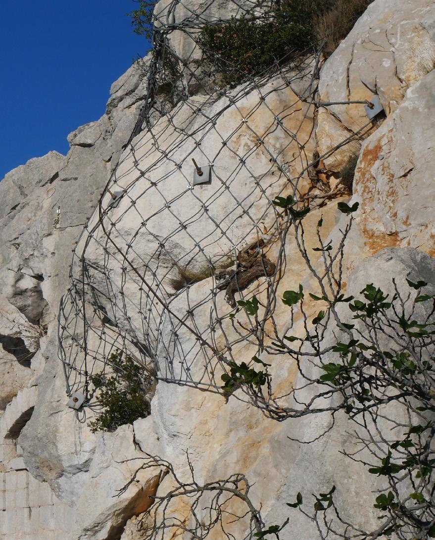
Even the smallest rock let loose from above is dangerous to anyone positioned in the fall line. Learn to recognize the potential danger of rockfall, both natural and human-caused.
Rockfall is just one of many accepted risks of venturing into the mountains. Rockfall can be a
Advertisement
single boulder careening down a cliff or a mass movement of rock
falling down a steep slope. And rockfall can have either a natural
or engineered cause.

MOTHER NATURE AT WORK
Cliff or hillside erosion is the means by which Mother Nature exfoliates. This natural process can become hazardous should an outdoor recreationalist stand in the way of a tumbling boulder or sliding cascade of rock, but also under a block cleaned by a lead climber or a rock kicked loose from a mountaineer on a ledge above. Understanding why and how rocks fall can help the aspiring adventurer avoid either triggering or encountering one of these dangerous rock movements.
HEAT AND RAIN
Heat and rain are major contributors to rock falls, causing or facilitating the natural physical and chemical weather of rock layers. A report by Yosemite National Park geologists indicates rain accounts for about 29% of rockfall.
Temperature fluctuation, especially heating, is the main culprit. The freeze-thaw cycles of seasonal changes, the hot sun-kissed days to chilly nights and the monsoon storms of the Southwest summer, contribute to physical weathering of mountain geology. Temperature fluctuations expand and compress rock, resulting in the loosening and fracturing of the outer layers.
Rock itself is a poor heat conductor. When heated, only the surface of the rock is affected while the core remains cool. This cycle of heating and cooling causes the outermost layers to expand with the

heat and contract when cooled, amassing stress known as thermal fatigue. Thermal fatigue causes stress between constituting mineral crystals resulting in fragmentation known as “granular disaggregation.” The resulting stress fractures break and weaken the rock from its connection point at the cliff.
CHEMICAL WEATHERING
Weather and seasonal changes also contribute to chemical weathering. Rocks are comprised of minerals. The constituent minerals can have a chemical reaction with oxygen, whether from the air, water from summer storms or snowmelt. A change in the chemical composition of the rock can cause stress between the mineral crystals, which, when temperature fluctuation again comes into play, promotes fragmentation, fracturing and exfoliation of the outermost rock layers.
OTHER FACTORS
With the outermost rock layers vulnerable to weathering, mass movements can be triggered by seismic activity, lightning, erosion of surrounding materials during a heavy rainstorm, root growth, extreme wind and more.
THE HUMAN FACTOR
Accepting risk is part of the necessary exchange for enjoying our wondrous planet. Rockfalls will happen. With a bit of knowledge, however, one can help minimize the risk of a great day turned calamitous.
Wherever you venture, avoid or be extremely cautious in areas where other rockfalls have obviously occurred. When rocks falls occur, they accumulate at the base of a cliff, chute, or slope. A talus pile, especially one at the base of a steep slope, indicates that the area below the slope may not be safe for recreation.
Watch the weather. Rain makes rock material less cohesive by reducing friction between cracks. It also contributes weight and volume to the overall mass, and thus increasing the gravitational force of the slope itself. Be alert while adventuring during the summer monsoon seasons, watching for signs of rockfall.
If you are new to adventuring, it is prudent to go with someone who can assess the safety the situation. Some cliffs are safer than others. Shorter cliffs have less rock material and therefore less rockfall potential, and longer cliffs have more rockfall potential. In keeping to that logic, a cliff with more overhang has more unstable rock material – more pull of gravity upon unsupported rock — than a cliff with less overhang.
For climbers and mountaineers, wearing a helmet could save your skull. Always be on the lookout for weathered rock. Assess all questionable blocks, whether rock climbing or ascending a ridge. Pull down rather than out on blocks. Should you happen to pull a block loose, give a warning cry to anyone who may be below.
ENGINEERED CAUSES
Trundling is the practice of throwing loose rock from a cliff or loosening a boulder to watch it cascade down a slope. Climbers are in the habit of removing bits of bad rock to lessen the risk of a larger accident occurring later. In climbing areas of our region, unlike, say, Yosemite, the climber isn’t thousands of feet above ground. With a good view, the climber can generally control where to safely toss the loose rock to where it will not threaten the safety of anyone below.
The blatantly irresponsible trundle is to loosen a boulder to watch it bounce down a slope. There’s no controlling that.
Either way, the practice could result in injury or fatality should someone stand in the path of the falling rock.
Stay safe and enjoy the next adventure with perhaps a little more knowledge than before.
LIS McLAUGHLIN is an outdoor enthusiast and freelance writer based in Durango, Colorado. A Fort Lewis graduate and humble student of philosophy, she balances her free time with writing, reading, fitness, and appreciating the beauty of nature.
Kaitlyn Alexander climbs in a remote area above Paradox Valley. photo by Terrance Siemon

COLORADO’S WEST END
A Treasure of Isolation & Recreation

AAt the onset of the pandemic, when Moab locked its doors and closed shop, the desert rats were turned away. Some went home. Others traveled elsewhere. Lucas This rich vein of recreation could transform former mining communities Johnson first noticed them in Paradox Valley, on routes that typically attract a handful of climbers throughout the year. Deana Sheriff saw tents and campervans cropping up on the public lands near Naturita and Nucla.
Trailheads were suddenly crowded by local standards: more than one or two cars.
By now, we know that pandemic recreation in rural areas was ill-advised, but for better or worse, it did introduce new outdoor enthusiasts to Colorado’s Canyon
Country. And local advocates hope they’ll keep coming. by MARGARET HEDDERMAN
The West End of Montrose County is marked by twisting red rock canyons and distant mountain ranges. It’s a dry and tumultuous landscape with an equally wild history of outlaws, utopian socialists and miners. It comprises the communities of Nucla, Naturita and the now abandoned town of Uravan, which became a Superfund Site in the 1980s. Two rivers – the
San Miguel and the Dolores – cut through this remote region, and over 600 miles of old exploration roads crisscross the landscape, offering endless mountain biking and hiking opportunities.
With four seasons of prime recreation weather, and vast tracks of public land ranging in elevation from 4,500 to 9,500 feet, it’s hard to believe this area hasn’t been discovered. ››
Exploring an old uranium road in the Dry Creek gorge. photo by West End Trail Alliance


Daredevil riding high above the Dolores River. photo by Jarrod Fast
Negotiating the narrow trail on Horse Bench high above the Paradox Valley. photo by West End Trail Alliance
“We have not promoted this area,” said Sheriff, the Executive Director of the West End Economic Development Corporation. “Historically this area was developed around the Manhattan Project and that era of secrecy has remained through the generations out here.”
The region was founded by farmers in the late 1800s, but is defined by its mining history. Uranium brought a wealth of money and new families to the area, but when its market price tanked in the 1980s, hundreds of mines closed. Coal helped bring a resurgence to the area, but recently Tri-State Generation and Transmission Association announced the mine and power plant would close by 2022.
Now, locals are looking toward outdoor recreation − as well as the area’s inherent solitude − to revitalize the economy.
For years, the old mining roads and trails were mostly accessed by local mountain bikers, hikers and hunters. There weren’t maps or guidebooks to help newcomers explore the area. But a few years ago the West End Trails Alliance (WETA) was formed to promote mountain biking and hiking opportunities in the area.
Looking south from the east rim above the Dolores River. The San Miguel River confluence and Naturita are upriver from here. photo by Jan Nesset

“It's a very unique part of Colorado, geologically, we have some of the most beautiful terrain you've ever seen,” said longtime resident Paul Koski. “That's what has kept me here for 40 years − the vast amount of public lands out here.”
Koski helped found WETA and is largely responsible for the development of the Paradox Trail, a 110-mile mountain biking trail that links two other long distance routes − the Tabeguache Trail and the Kokopelli Trail – into the 360- mile circuit known as the Grand Loop.
Through its inventory of local trails, WETA has produced an abbreviated online catalog of hiking and mountain biking opportunities in the area. Maps are now available in local shops and hotels, and the organization is working to produce signage on the more popular trails.
Despite efforts to make recreation more accessible to visitors, the West End is still largely undeveloped. According to Lucas Johnson, Nucla’s “resident climber” as Koski refers to him, adventuring is still an adventure out here.
“Every time the river turns, there’s a band of Dakota sandstone along the rim,” Johnson said. “They’re pretty much all tackled and climbed.”
Dry Creek Gorge at the extreme West End incline. photo by West End Trail Alliance

North buttress of Nyswonger Mesa above the Paradox Valley. photo by West End Trail Alliance

Many of the bolted routes are older and Johnson acknowledges that some people “blanche” at the hardware. However, he points to the numerous trad routes, as well as the boulders strewn along the main highway which offer a variety of grades.
“The bouldering here along 141, all the way down the Gateway Canyon is incredible,” Johnson said. “It’s very van-livable.”
Most of the routes are on Mountain Project, or if you can get your hands on a copy, Charlie Fowler and Damon Johnston’s out-of-print The Wild Wild West.
Comparing recreation in the West End to the Wild West is kind of appropriate. The isolation paired with limited cell phone service and low population density demands a level of self-sufficiency and experience. In a world of pre-programmed adventure, that’s particularly attractive to a certain subset of travelers.
“We’re redeveloping our brand around being isolated,” Sheriff said. “You can be out here for 12 days and never see another person.”
Promoting isolation feels like a self-defeating endeavor, but Sheriff said it’s unlikely the West End will see
Descending the rough trail off Nyswonger Mesa above Bedrock, Colorado. photo by West End Trail Alliance

unreasonable growth as it’s difficult to access and doesn’t have major attractions like national parks.
“I frequently hear ‘don’t turn us into Moab,’” Sheriff said. “I think our growth is going to be really slow just because we aren’t going to be able to attract that international market.”
Even so, outdoor recreation and tourism appear to be having an effect. A new glamping park and a bed and breakfast are set to open this summer, and a few outdoor businesses are already catering to the small, yet growing number of visitors.
“Any activity is going to help,” Koski said. “We are small towns. We don’t need a huge influx of people to really impact our local economy.”
MARGARET HEDDERMAN writes about the environment, outdoor recreation, and travel. Based in Boulder, Colorado, her work has also appeared in Nowhere Magazine, Sierra, and has been nominated for The Best American Travel Writing series.


camera Nikon D800 focal length 24mm iso 1600 exposure 30sec aperture f/2.8
camera Nikon D800 focal length 14mm iso 200 exposure 1/400 aperture f/4
RIO GRANDE GORGE
While on an Adventure Pro shoot in the Rio Grande Gorge near Taos, New Mexico, I got busy shooting a climber who was tackling some interesting bouldering problems near the rim of the gorge. Looking for a dramatic composition to show the steepness of the terrain over the Rio Grande River, I positioned myself above the climber. Anticipating that he would use this hold once he arrived at the top of the climb, I settled into place and waited. I framed the hold to be in the foreground and put the focus on the background. It worked!
by TERRANCE SIEMON
MOTION BLUR
Creating movement is a fun technique that can add life to an action shot. You achieve a photo with movement by setting the focus point on the subject and keeping the camera trained on the subject at a slow shutter speed. The key is to keep the focus point (the subject) in that sharp field of view as the camera moves in sync with the subject.
For this photograph I set the shutter speed to 1/80 of a second, which is extremely slow for action photos. I panned my camera across the trail with the mountain biker as she rode through the frame. The goal is to match the pan of the camera to the speed of the rider. If successful the rider stays in focus and the background streaks, giving it the motion blur due to the longer exposure. (It always takes a few tries.)


