25 minute read
La lapide murata di San Giovanni Valdarno, un brand dell’urbanistica gotica Maria Teresa Bartoli

La lapide murata sulla parete orientale del Palazzo Pretorio di San Giovanni Valdarno reca una scritta che allude ad alcune misure del disegno gotico della città di San Giovanni, prima terra nuova fondata da Firenze nel suo territorio. La ricerca del disegno della pianta gotica della città, con il controllo metrico della planimetria attuale e l’aiuto di due rilievi del XVI secolo, ha ricostruito figura e misure, mettendone in luce la logica che appare legata a due paradigmi del matematico pisano Leonardo Fibonacci: i numeri della Serie e il calcolo delle aree sui multipli dello staioro.
The plaque on the eastern wall of Palazzo Pretorio in San Giovanni Valdarno bears an inscription which alludes to certain measurements concerning the Gothic design of the city of San Giovanni, first of the New Lands founded by Florence in its territory. The research carried out on the design of the Gothic plan of the city, with the metric control of the current planimetry and support from two 16 th
Advertisement
century surveys, reconstructed both the figure and its measures, highlighting the logic reasoning which seems connected to two paradigms by the Pisan mathematician Leonardo Fibonacci: the numbers of the Series and the calculation of the areas on the multiples of the staioro.
La lapide murata di San Giovanni Valdarno, un brand dell’urbanistica gotica The walled plaque at San Giovanni Valdarno, a brand of Gothic urbanism
Maria Teresa Bartoli
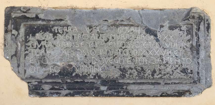
L’oggetto di questo saggio è un concio di pietra arenaria assai degradato, murato sotto il loggiato orientale del Palazzo Pretorio, nella città di San Giovanni Valdarno. L’epigrafe (di caratteri gotici, non interamente leggibile e priva di date) dà solo alcune informazioni metriche sulle mura della Terra Nuova di San Giovanni.
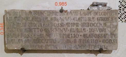
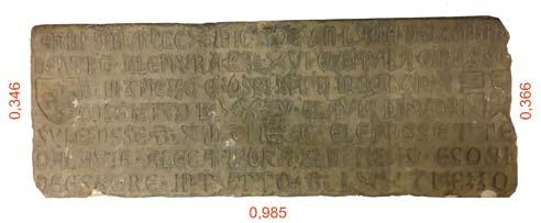
«TERRA NUOVA […] GOVA […] / LA VIA DENTRO ALLE MURA LARGA B XX / MURA GROSSE B 1 1/2 IL FOSSO ET LA VIA IN / TORNO AL FOSSO IN TUTTO B XXXVII ET1/2 / ET QU[…] DOVE GLI E FONDAMENTO / O M […]RMINE […]» L’iscrizione non è del tutto originale: si conservano nel Museo di San Marco molte lapidi marmoree, salvate dalla demolizione delle mura di Firenze sulle quali erano collocate (in prossimità delle porte), che documentavano la data di ultimazione dei diversi tratti di mura (primi decenni del XIV secolo) e le misure della loro sezione trasversale, in maniera molto simile a quella della pietra di San Giovanni 1
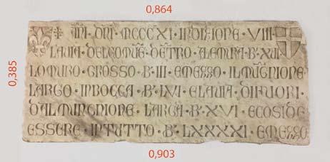
. È ancora presente sul posto la targa della Porta la Croce: «Anni D[omi]ni MCCCX idictio([n]e VIII. La via del Comune / dentro ale mura è br[accia] XVI e le mura grosse / br[accia] III [e] mezzo, e fossi anpii in boccha / col gietto br[accia] XXXV e la via di fuori / sule fosse br[accia] XIII [e] mezzo, e le fossette / dala via ale campora br[accia] II [e] mezzo. E così / de’ essere in tutto br[accia] LXX [e] mezzo». Se il contenuto delle epigrafi è simile, si nota però la mancanza nella nostra pietra del riferimento tipico delle iscrizioni: l’anno. Inoltre, la lapide di San Giovanni differisce da quelle fiorentine per la forma complessiva della pietra, decorata da una spessa cornice con modani, assente in quelle fiorentine. Altra interessante differenza è il modo di comunicare il numero mezzo, scritto non con lettere in caratteri romani, ma con la grafica delle frazioni.
The subject of this essay is a sandstone slab in a state of decay, set into a wall under the eastern loggia of Palazzo Pretorio, in the city of San Giovanni Valdarno. The epigraph (in Gothic characters, not entirely legible and undated) provides only some metric information concerning the walls of the Terra Nuova, or New Land of San Giovanni. «TERRA NUOVA […] GOVA […] / LA VIA DENTRO ALLE MURA LARGA B XX / MURA GROSSE B 1 1/2 IL FOSSO ET LA VIA IN / TORNO AL FOSSO IN TUTTO B XXXVII ET1/2 / ET QU[…] DOVE GLI E FONDAMENTO / O M […]RMINE […]» The inscription is not entirely original: there are many gravestones at the Museum of San Marco, saved from the destruction of the walls of Florence on which they were set (in proximity of the gates), which documented the dates concerning the completion of various sections of the wall (first decades of the 14 th
century) and the measures of their transverse section, in a way similar to that of the stone in San Giovanni 1
. One such plaque still stands in its place at Porta la Croce:
«Anni D[omi]ni MCCCX idictio([n]e VIII. La via del Comune / dentro ale mura è br[accia] XVI e le mura grosse / br[accia] III [e] mezzo, e fossi anpii in boccha / col gietto br[accia] XXXV e la via di fuori / sule fosse br[accia] XIII [e] mezzo, e le fossette / dala via ale campora br[accia] II [e] mezzo. E così / de’ essere in tutto br[accia] LXX [e] mezzo». Although the content of the epigraphs is similar, the stone that concerns us is lacking one of the typical references included in the inscriptions: the year. Furthermore, the stone plaque of San Giovanni differs from its Florentine counterparts in terms of the overall form of the stone, which is decorated with a thick frame with mouldings, absent in those from Florence. Another interesting difference is the
p. 144 Schema per il calcolo dei perimetri basato sulla formula suggerita dal matematico Giuseppe Conti descritta nel testo e in nota 7 p. 145 La lapide sul muro del Palazzo Pretorio di San Giovanni L’esadecagono di Vitruvio sopra la pianta di San Giovanni con evidenziato il centro storico
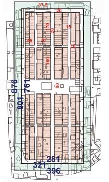
Disegno di rilievo della lapide Schema del progetto gotico sopra la pianta attuale (i lati dei rettangoli misurano rispettivamente 281x761, 321x801 e 396x876 braccia) La terra nova sopra il disegno della lapide p. 147 Lapide mura Firenze, pietra arenaria, 1310 Lapide mura Firenze, pietra arenaria, 1311 Lapide mura Firenze, marmo, 1311 (Firenze, Museo di San Marco)

Ho recentemente dedicato alla pianta gotica di San Giovanni Valdarno uno studio rivolto alla messa in luce del suo disegno originario 2
, sulla base di una serie di documenti, tra i quali, oltre al testo della lapide, la pianta del centro storico attuale tratto dalla planimetria dell’U.T.C., due rilievi del XVI secolo, conservati all’Archivio Storico Fiorentino, riprodotti e trascritti nel fondamentale volume di David Friedman sulle Terre Nuove di Firenze 3
. Lo studio ha messo in evidenza alcuni aspetti paradigmatici del disegno gotico della città. In seguito, la lapide, meditata alla luce di tali paradigmi, ha rivelato una parentela insospettata con la forma urbana, assumendo una valenza simbolica speciale. L’obbiettivo del progettista di quel manufatto (non un semplice lapicida) fu un’operazione intellettuale non nella sola composizione letteraria, ma anche nel disegno della forma.
I paradigmi del disegno gotico di San Giovanni Valdarno I risultati dello studio condotto vengono riassunti nello schema che sintetizza l’ipotesi del disegno originario della pianta. Essa fa riferimento al sistema metrico della repubblica fiorentina, le cui lunghezze lineari erano basate sul braccio da panno (lungo
way in which the number mezzo, or ‘half’ is communicated: not with Roman numerals but with the symbols used for fractions. I recently carried out research aimed at highlighting the original design of the Gothic plan of San Giovanni Valdarno 2
, on the basis of a series of documents, among which, in addition to the text of the plaque, the plan of the current historic centre taken from the planimetry of the U.T.C., and two surveys from the 16 th
century kept at the Archivio Storico Fiorentino, reproduced and transcribed in David Friedman’s fundamental work on Florence’s New Lands 3
. The study highlighted certain paradigmatic aspects of the Gothic design of the city. Subsequently the stone plaque, interpreted in the light of the said paradigms, revealed an unexpected relation to the urban form, assuming a special symbolical value. The aim of whoever designed that artifact (not a simple stonemason) was an intellectual operation, not only as literary composition but also in the design of its form.
The paradigms of the Gothic design of San Giovanni Valdarno The results of the study are summarised in the diagramme that sums up the hypothesis of the original design of the plan. It refers to the metric system of the Florentine republic, whose linear lengths were
0,5836 metri) e sulla pertica di 5 braccia; le lunghezze di superficie si conformavano allo staioro descritto da Fibonacci nella Practica Geometriae 4
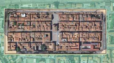
, pari a 66 pertiche quadre o 1650 braccia quadre. Due rilievi, fatti verso la metà del secolo XVI l’uno dai Maestri Gentile e Batista e l’altro (dopo l’alluvione di metà secolo che distrusse l’estremità meridionale della città) dal Maestro Zucca, riportano, in forma diversa, le misure degli isolati e delle strade e permettono di ricostruire uno schema misurato di pianta confrontabile con la situazione attuale. All’interno di un rettangolo di mura, quattro quartieri, di quattro isolati ciascuno, erano distribuiti con simmetria sui vuoti della croce generata da una strada maestra e una vasta piazza trasversale. All’interno di ogni quartiere, gli isolati erano divisi da una strada longitudinale che sboccava sulla piazza, ed una trasversale assai più stretta, che sboccava sulla via maestra. Tutt’intorno alle mura correva all’interno una strada di uniforme larghezza (20 br.) e all’esterno una striscia di terra dedicata al fossato e alla via intorno ad esso (37,5 br.). Nella piazza erano collocati il Palazzo del Podestà lungo la via maestra e la Pieve a oriente. Quattro porte erano poste alla metà dei lati del rettangolo di mura, due allo sbocco della
based on the Florentine fathom or braccio da panno (0.5836 meters) and on the 5 fathom pertica, or rod; surface lengths conform to the staioro described by Fibonacci in his Practica Geometriae 4
, which equals 66 square perticae or 1650 square fathoms. Two surveys undertaken toward the half of the 16 th
century, one by masters Gentile and Batista and the other (after the flood that destroyed the southern part of the city) by master Zucca record in different way the measurements of the city blocks and streets, allowing the reconstruction of a layout for the plan that is comparable to the current situation. Within a rectangle of walls four quarters, composed of four blocks each, were divided by a longitudinal street that arrived onto the square, and a transverse street, considerably narrower, that arrived onto the via maestra, or main road. All around the walls there was a road with the same width (20 fathoms) on the outside of which ran a strip of land which included a moat and another road alongside it (37.5 fathoms). In the square stood the governor’s palace (Palazzo del Podestà) along the via maestra and to the east the Pieve, or parish church. There were four gates in the middle of each side of the rectangle of walls, two on the ends of the main road and two to the flanks of the square. The measures, expressed in the metric system
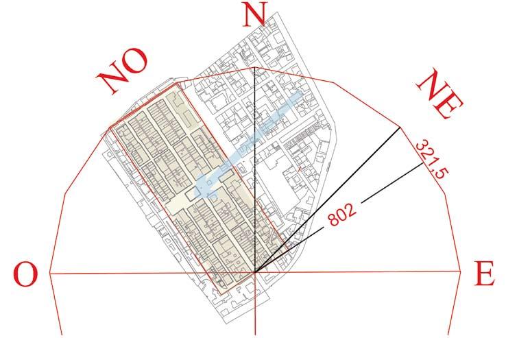
strada maestra e due sui fianchi della piazza. Le misure, espresse nel sistema metrico del tempo, rendono evidente l’intenzione. Tre sono i rettangoli riconoscibili nello schema planimetrico: 1 - il rettangolo dell’edificato aveva un perimetro (al netto della strada sotto le mura) di 282 x 760 braccia; la superficie calcolata di 214320 brq corrisponde quasi esattamente a 130 staiora (= 214500 brq). 2 - Il rettangolo delle mura era lungo 800/802 braccia e largo 321/ 322 braccia; la sua superficie vale poco più di 156 staiora, ma ciò che colpisce nei numeri del perimetro è il loro rapporto (320:800 = 2:5). Esso approssima con minima tolleranza (poco più del 2‰) il rapporto tra il lato dell’esadecagono e il raggio del cerchio al quale è circoscritto. L’esadecagono è il poligono che per Vitruvio determina con esattezza la direzione più adatta del reticolo delle strade, per salvaguardare gli abitanti dai venti più forti: tenuto conto che nella piana dell’Arno il vento di Nord-Est è il più violento, nel centro storico le mura degli edifici, parallele alle strade, si frappongono correttamente tra la rete viaria e l’impeto dei venti. 3 - Il rettangolo disegnato dalla via fuori le mura, di lati 875 e 396, ha la superficie esatta di 210 staiora (=346500 brq). Abbiamo quindi due valori di superficie dentro e fuori le mura che valgono 130 e 210 staiora, due numeri della Serie di Fibonacci nelle centinaia 5
, che possono aver rappresentato due traguardi da raggiungere nelle intenzioni del progetto 6
. Il tema del progetto sarebbe stato la determinazione dei lati di una sequenza di tre rettangoli tali che quello intermedio offre il rapporto h/l = 2/5; gli altri due, entrambi a quartabono del rettangolo intermedio, devono avere l’area espressa dai due numeri successivi della Serie. L’idea di applicare al disegno della città la sequenza del matematico pisano educato dagli arabi ci avverte di una contaminazione con l’oriente islamico, dove già nell’VIII secolo era stata fondata la Città della Pace (Bagdad), di figura perfettamente circolare. Come si raggiunge questo risultato? Ho girato il problema al matematico amico Prof. Giuseppe Conti, che mi ha dato l’elegante soluzione 7
. Se fissiamo nella misura di 20 braccia la distanza delle mura dal rettangolo interno, la soluzione, impostata in forma algebrica, dà esattamente i numeri che abbiamo misurato nel nostro disegno. Lo svolgimento implica conoscenze di matematica alla portata degli abacisti presenti a Firenze alla fine del XIII secolo. I paradigmi che ne emergono discendono dall’autorità indiscutibile del Fibonacci.
I paradigmi nella lapide Nella lapide murata nella loggia del palazzo, una doppia cornice è modellata attorno al rettangolo centrale sul quale sta l’iscrizione. Valutate le sue proporzioni, non può sfuggire la loro somiglianza a quelle del rettangolo delle mura. Le misure esterne della cornice sono (98 x 43) cm. La superficie della pietra è quindi di cm 2
4214. Confrontata al braccio quadro (58,362 = 3400 cm 2
) la superficie vale (4214: 3400 = 1,24), circa un braccio e un quarto (cm 2
4250). La superficie del rettangolo entro la prima modanatura è (91,6 x 37,1) cm 2
= 3400 cm 2
= 1 br. q. Le lunghezze dei lati (in denari 377 e 150 = 5:2) hanno le stesse proporzioni del rettangolo delle mura, che abbiamo associato all’esadecagono. All’interno di questo rettangolo, una seconda cornice (assai deteriorata, simile ad una gola, ma forse composta di due parti, un toro e un listello) delimita il campo rettangolare della scritta, lungo cm 80,8, alto cm 26. La superficie è cm 2
2100; 3400 cm 2 : 2100 cm 2
= 1,619 (il numero della sezione aurea è 1,618). Le aree dei due rettangoli esprimono la stessa relazione esistente tra i rettangoli esterno ed interno di San Giovanni. La lapide appare ora come la materializzazione della figura geometrica di appoggio della sequenza di operazioni algebriche che risolvono l’esercizio che chiede che un rettangolo di proporzioni of the time, render the intention evident. There are three rectangles that can be recognised in the planimetry: 1 - the rectangle of the built area had a perimeter (following the street under the walls) of 282 x 760 fathoms; the calculated surface of 214320 square fathoms corresponds almost exactly to 130 staiora (= 214500 square fathoms). 2 - The rectangle of the wall was 800/802 fathoms long and 321/ 322 fathoms wide; its surface was slightly over 156 staiora, but what is striking about the numbers of the perimeter is their ratio (320:800 = 2:5). It approximates with minimal tolerance (a little over 2‰) the ratio between the side of the hexadecagon and the radius of the circle that circumscribes it. The hexadecagon is the polygon that determined for Vitruvius with exactitude the most adequate direction of the network of streets in order to safeguard the inhabitants from strong winds: considering that in the Arno valley the north-east wind is the strongest, in the historic centre the walls of buildings, parallel to the streets, are correctly used as protection against the force of the winds. 3 - The rectangle formed by the road outside the walls, with sides measuring 875 and 396, has a surface of exactly 210 staiora (=346500 square fathoms). We thus have two surface values inside and outside the walls equal to 130 and 210 staiora, two numbers of the Fibonacci series in the hundreds 5
, which may have represented two goals to be reached in the intentions of the project 6
. The theme of the project would have been to determine the sides of a sequence of three rectangles so that he middle one would have the ratio h/l = 2/5; the other two, both bevelled in relation to the middle rectangle, must have areas expressed by two successive numbers of the series. The idea of applying to the design of the city the sequence of the Pisan mathematician, educated by the Arabs, reveals a contamination with Islamic orient, where already in the 8 th
century the City of Peace (Baghdad) had been founded on a perfectly circular plan. How is this result obtained? I presented the problem to a mathematician friend of mine, Prof. Giuseppe Conti, who proposed an elegant solution 7
. If we fixed the distance of the interior rectangle from the wall at 20 fathoms, the solution, presented in algebraic form, results in exactly the same numbers we measured on our drawing. This implies the degree of mathematical knowledge available to Florentine abacists toward the end of the 8 th
century. The paradigms that emerge from this are undoubtedly derived from Fibonacci.
The paradigms of the stone plaque In the walled plaque of the loggia of the palace, a double frame is set surrounding the central rectangle on which lies the inscription. Evaluating its proportions it is impossible to ignore their similitude to those of the rectangle of the walls. The external measures of the frame are 98 x 43 cm. The surface of the stone is therefore 4214 cm 2
. In terms of square fathoms (58,362 = 3400 cm 2
) the surface is equal to (4214: 3400 = 1,24), that is approximately a fathom and a fourth (4250 cm 2
). The surface of the rectangle within the first moulding is 91.6 x 37.1 cm 2
= 3400 cm 2
= 1 square fathom. The lengths of the sides (in denari 377 and 150 = 5:2) have the same proportions as the rectangle of the walls, which we associated to the hexadecagon. Within this rectangle, a second frame (in a state of great decay, similar to a gorge, but perhaps composed of two parts, a torus and a listel) delimits the rectangular field of the inscription, 80.8 cm long and 26 cm high. The surface is equal to 2100 cm 2
; 3400 cm 2
: 2100 cm 2
= 1,619 (the number for the golden section is 1.618). The areas of the two rectangles express the same ratio that exists between the exterior and interior rectangles of San Giovanni. The stone plaque now appears as the materialisation of the geometric figure in support of the sequence of algebraic operations that resolve
2:5 e superficie un braccio quadro divenga cornice di un altro rettangolo la cui superficie stia con la precedente nel rapporto prossimo alla sezione aurea. Per dare maggiore credito alle considerazioni svolte, si sono esaminate con analogo metro le lapidi delle mura di Firenze, per rilevare quali delle caratteristiche della nostra (a parte il testo di cui abbiamo scritto sopra) siano presenti in queste. Nel museo di San Marco se ne trovano quattro, di cui una però in stato di non misurabilità perché rotta e assemblata in maniera poco probabile. Tutte sono costituite da conci di forma pressoché rettangolare, privi di cornice. La più antica del 1310, di pietra arenaria, forse la più regolare, è lunga cm 98,5 x 34,6. La superficie misura cm 2
3408, ovvero 1 braccio quadro. Il rapporto è prossimo a 2,85. La successiva dello stesso materiale è del 1311 ed è lievemente irregolare; la sua lunghezza è la stessa della precedente (cm 98,5), l’altezza del lato sinistro è pari a quella della precedente (cm 34,6), ma a destra diventa 36,6. La sua superficie misura cm 2
3545, quindi poco più di 1 braccio quadro. Infine, la terza, marmorea, anch’essa del 1311, ha misure diverse dalle precedenti: assimilabile ad un trapezio isoscele, la semisomma delle basi è lunga cm 88,6 e l’altezza è di cm 38,5 (il loro rapporto è 2,3). L’area è 3411, ancora una volta circa 1 braccio quadro. A confronto con le lapidi fiorentine, anche se rimane comune a tutte la volontà di associare la pietra alla misura del braccio quadro, la forma della lapide di San Giovanni appare diversa, e non è negabile l’intenzione di attribuirle dimensioni e proporzioni dotate di significato. Non è probabile che sia stato il lapicida a pensare questa forma; forse il disegno utilizzato da un matematico nel laboratorio di progettazione arnolfiano per spiegare come dovevano procedere i calcoli per il disegno di San Giovanni è divenuto il modello dato al lapicida per collocare la scritta; forse quel disegno, inteso come esempio del metodo da utilizzare per il progetto urbano, fu considerato emblematico dell’azione rivolta alle fondazioni di terre nuove. Se il contenuto letterario, modellato sulle iscrizioni delle mura fiorentine, indicava l’appartenenza alla Repubblica, il disegno della lapide rappresentava la sintesi del processo risolutore del programma ideato.
1
Vedi M. Pantarotto, Il giglio e la croce sulle mura di Firenze in «Opera · Nomina · Historiae» Rivista semestrale on line, 7/2012, http://onh.giornale.sns.it, pp. 67-88. Ringrazio lo studioso Tommaso Gramigni per avermi segnalato l’articolo. 2
M.T. Bartoli,The Gothic Design of San Giovanni Valdarno in «Disegnare con», volume 10, n.19 - dicembre 2017, http://disegnarecon.univaq.it 3
D. Friedman, Terre nuove, la creazione delle città fiorentine nel tardo medioevo, Einaudi, Torino 1996. I documenti cui ci si riferisce sono il 22 e 23 (p. 316 e 317). Iscrizioni sulla pianta di San Giovanni Valdarno, e la relativa fig. 4. In essi sono riportati i testi e le figure relativi al rilievo dei maestri Gentile e Battista e a quello del Maestro Zucca. L’analisi di questi documenti è stata integrata da rilievi svolti sul posto nel corso di una esperienza didattica nell’anno 2016. 4
Sulle misure nell’architettura fiorentina gotica, vedi M.T. Bartoli, Musso e non quadro, la strana forma di Palazzo Vecchio dal suo rilievo, Edifir, Firenze 2007, pp. 19-25. 5
I numeri della serie sono 0,1,1,2,3,5,8,13,21,34,55, ecc, ognuno uguale alla somma degli ultimi due che lo precedono. Il rapporto tra 13 e 21 è 0,619. La serie nasce dall’osservazione di organismi naturali che nella loro crescita si uniformano alla serie. 6
Il legame di Arnolfo da Cambio (indicato dalla tradizione come l’autore del progetto di San Giovanni) con la serie di Fibonacci è dimostrato in modo indubitabile dal disegno di Palazzo Vecchio, e la terra nuova lo confermerebbe. 7
La soluzione del problema è la seguente secondo Giuseppe Conti: rettangolo delle mura: sono definite le proporzioni 2:5, ma non ne conosciamo l’estensione; area rettangolo interno: conosciamo l’estensione (130 staiora = 214500 brq), e sappiamo che il suo perimetro deve essere tale da avere le mura come cornice a distanza costante dai suoi lati. Fissiamo nella misura di 20 braccia tale distanza. Y (lato corto) e Z (lato lungo) sono i lati incogniti il cui prodotto deve essere 130 staiora; stabiliamo che 20 deve essere la larghezza della strada sotto le mura. Il circuito delle mura deve avere i lati lunghi 2X e 5X. YZ = 214255 (130 staiora); Y + 40 = 2 X; Z + 40 = 5 X; 5 Y + 200 = 10 X; 2 Z + 80 = 10 X; 5 Y + 200 = 2 Z + 80; Z = 5/2 Y + 60; possiamo quindi scrivere, sostituendo questa espressione di Z nella prima: 5/2 Y 2
+ 60 Y = 214500, il cui svolgimento dà a Y il valore di 281,6; Z = 5/2 x 281,6 + 60 = 762; X = 160,5. Ora possiamo definire le lunghezze delle mura: 160,5 x 2 = 321 e 160,5 x 5 = 802,5. Area del rettangolo fuori le mura: conosciamo la sua estensione (210 staiora = 346500 brq), e sappiamo che i suoi lati devono avere la stessa distanza dal rettangolo delle mura. La formula è: (321 + 2T) x (802 + 2T) = 346500; svolgendo, T 2
+ 561,5 T – 22264,5 = 0, da cui T = 37,4.
the exercise which requires a 2:5 rectangle with a surface of a square fathom to become the frame of another rectangle whose surface remains as the previous within a ratio close to the golden section. In order to give greater credit to these considerations, the stone plaques from the walls in Florence were examined in the same way, so as to determine which of the features of the plaque from San Giovanni (excepting the text, we already discussed above) are present in them. Four are kept at the museum of San Marco, one of which, however, cannot be properly measured because it is broken and re-assembled in an unlikely manner. All of them consists in almost rectangular slabs and are without frame. The oldest, from 1310, is in sandstone and is perhaps the most regular. It is 98.5 x 34.6 and has a surface of 3408 cm 2
, or 1 square fathom. The ratio is close to 2.85. The second, also in sandstone, is from 1311 and is slightly irregular; it has the same length as the previous one (98.5 cm), as is the height on its left side (34.6 cm), yet on its right side it is slightly higher (36.6 cm). It has a surface of 3545 cm 2
, thus slightly more than 1 square fathom. Finally the third, in marble and also from 1311, is different in size and shape to the others: similar to an isosceles trapezoid, the half-sum of the bases is 88.6 cm long and 38.5 cm high (the ratio is 2.3). The surface area is 3411, in other words once again approximately 1 square fathom. In comparison with the Florentine stone plaques, although the common intention to associate the stone to the measure of the square fathom remains, the form of the plaque at San Giovanni appears different, and the wish to attribute to it dimensions and proportions bearing meaning cannot be denied. It is not probable that it was the stonemason to think this shape; perhaps it was a drawing used by a mathematician in the Arnulfian design workshop in order to explain how the calculations for the design of San Giovanni should proceed which became the model for the stonemason to place the inscription; perhaps that design, which was to be understood as an example of the method to use for the urban development project, was considered emblematic of the action aimed at the foundation of new lands. If the literary content, modelled on the inscription of the Florentine walls, indicated a belonging to the Republic, the design of the stone plaque represented the synthesis of the process for resolving the envisaged programme.
Translation by Luis Gatt
1
See M. Pantarotto, Il giglio e la croce sulle mura di Firenze in «Opera · Nomina · Historiae» Bi-annual on line journal, 7/2012, http://onh.giornale.sns.it, pp. 67-88. I thank Tommaso Gramigni for having brought the article to my attention. 2
M.T. Bartoli, The Gothic Design of San Giovanni Valdarno in «Disegnare con», volume 10, n.19 - December 2017, http://disegnarecon.univaq.it 3
D. Friedman, Terre nuove, la creazione delle città fiorentine nel tardo medioevo, Einaudi, Torino 1996. The documents referred to are numbers 22 and 23 (p. 316 and 317). The inscriptions on the plan of San Giovanni Valdarno, and the relative fig. 4. They include texts and figures relative to the surveys by masters Gentile and Battista and by Maestro Zucca. The analysis of these documents was supplemented with surveys carried out on site during an educational project undertaken in 2016. 4
Concerning measures in Florentine Gothic architecture see M.T. Bartoli, Musso e non quadro, la strana forma di Palazzo Vecchio dal suo rilievo, Edifir, Firenze 2007, pp. 19-25. 5
The numbers of the series are 0,1,1,2,3,5,8,13,21,34,55, etc., each equal to the sum of the two that precede it. The ratio between 13 and 21 is 0,619. The series originates from the observation of natural organisms whose growth adheres to the series. 6
The connection of Arnolfo da Cambio (traditionally considered as the author of the project for San Giovanni) to the Fibonacci series is proven beyond doubt in the design for Palazzo Vecchio, and the New Land would confirm this. 7
The solution of the problem is as follows, according to Giuseppe Conti: rectangle of the walls: the proportions are determined as 2:5, yet we ignore their extension; area of the interior rectangle: we know the extension (130 staiora = 214500 square fathoms), and we know that its perimeter must be such as to have the wall as frame at a constant distance from its sides. We establish this distance as 20 fathoms (braccia). Y (short side) and Z (long side) are the unknown sides whose product must be 130 staiora; we determine that 20 must be the width of the road under the wall. The sides of the circuit of the walls must be 2X and 5X long. YZ = 214255 (130 staiora); Y + 40 = 2 X; Z + 40 = 5 X; 5 Y + 200 = 10 X; 2 Z + 80 = 10 X; 5 Y + 200 = 2 Z + 80; Z = 5/2 Y + 60; we can therefore say, substituting this expression of Z in the first: 5/2 Y 2
+ 60 Y = 214500, which results in a value of 281,6 for Y; Z = 5/2 x 281,6 + 60 = 762; X = 160,5. We can now determine the length of the walls: 160,5 x 2 = 321 e 160,5 x 5 = 802,5. Area of the rectangle outside the walls: we know its extension (210 staiora = 346500 square fathoms), and we know that its sides must have the same distance from the rectangle of the walls. The formula is: (321 + 2T) x (802 + 2T) = 346500; developing as, T 2
+ 561,5 T – 22264,5 = 0, of which T = 37,4.


