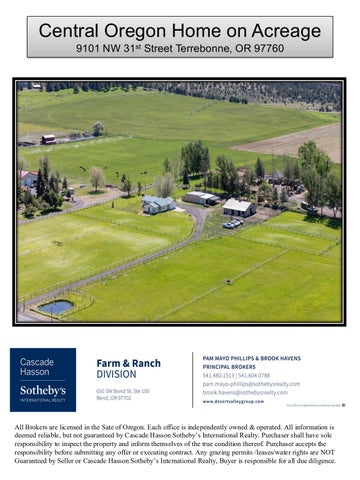
Central Oregon Home on Acreage 9101 NW 31st Street Terrebonne, OR 97760
All Brokers are licensed in the Sate of Oregon. Each office is independently owned & operated. All information is deemed reliable, but not guaranteed by Cascade Hasson Sotheby’s International Realty. Purchaser shall have sole responsibility to inspect the property and inform themselves of the true condition thereof. Purchaser accepts the responsibility before submitting any offer or executing contract. Any grazing permits /leases/water rights are NOT Guaranteed by Seller or Cascade Hasson Sotheby’s International Realty, Buyer is responsible for all due diligence.
Country Home, Shop, Barn & Acreage Address: 9101 NW 31st Street Terrebonne, OR 97760 Tax Map: 141317 01800 Parcel 128088 Property:
•9.89 acres of land including 8.9 acres COID water rights •Ranch style home 2,062 sq ft, featuring 3 bedrooms, office/4th bedroom, living room, family room, dining area, 3.5 bathrooms and utility room built in 1979. •Two bedroom suites Primary suite with jetted tub, tile shower, walk in •Heat: Central Air, Heat Pump, Furnace new 2021, 2 water heaters •Attached two car garage •RV Hookups •Great Outdoor living with Deck and yard •Shop with equipment storage and dog kennel with fenced yard •Livestock barn with runs, could be 6 stalls •4 automatic waters on property •Paddocks planted in grass •Shop and equipment storage area with an adjoining dog kennel and yard •Ready for livestock: fenced with alley ways, 6000 +/- ft of wood top rail fence cross fenced with no-climb wire •The property is well maintained and move in ready
Irrigation: 8.9 acres COID water rights, Pond with 7.5 HP Pump Two wheel lines, underground sprinklers Domestic Water: Private Well Utilities: Pacific Power Company 12 month averages 2 meters Residential: $361. High Average $165. Shop/Irrigation Average: $209. High $434. Taxes: 2025 $4,483.34 Farm Tax Deferral Zoning: EFUTE Exclusive Farm Use Price: $949,000.
MLS 220212850
Shown By Appointment Only All information Provided by Cascade Hasson Sotheby’s International Realty and Agents is deemed reliable but not guaranteed, Buyer is responsible for any/all due diligence. | 541-923-1376 | www.desertvalleygroup.com
Central Oregon Irrigation District
5141
11/25/2025 1:25 pm
Patron Taxlot Inquiry
Allen D. Kallel Rev. Trust $1,020.59 01/27/2025 $0.00
Last Assessment Amount: Last Assessment Date: Current Balance:
DistrictText
Division
Acreage
Beat
Division 1
8.900
PB4
County Tax Map Nbr
County Name
Address1
1413170001800
Deschutes
9101 NW 31ST ST TERREBONNE, OR 97760
Acreage
8.900
8.900
TRSQ
Lot
Usage
Headgate
141317SWNW
01800
Irrigation
F-6-10
Beneficial Use:
2024 - Partial 2021 - Partial
Quit Instream Claim Lease
2023 - Partial 2020 - Partial
Rot#
2022 - Partial 2019 - Partial
Transfer
Petition
Acreage
Acreage: Off Lands: On Lands: Available:
Page 1 of 1
8.900
8.900
COID WATER RIGHTS MAP LEGEND
PAST 5 2024 ACRES TAXLOTS IRRIGATED_LANDS STREETS
31ST
8.9 ac.
0.04 ac 0.11 ac 0.07 ac
0.31 ac
0.01 ac
NAME:
0
65
130
260 Feet
2025 AERIAL IMAGE
Date: 11/25/2025
TAXLOT(S): 1413170001800
DISCLAIMER: THIS MAP IS FOR REFERENCE PURPOSES ONLY. COID MAKES NO GUARANTEES TO THE ACCURACY OF THIS MAP OR ITS ASSOCIATED GIS DATA SHOWN HEREIN. COID IS IN NO WAY RESPONSIBLE FOR THE USAGE OF ANY DATA OR INORMATION ASSOCIATED WITH OR SHOWN ON THIS MAP.
1 inch = 100 feet User Name: GISTECH PROJECTION COORDINATE SYSTEM: NAD_1983_StatePlane_Oregon_South_ FIPS_3602_INTL Feet
Document Path: C:\Users\GIStech\Desktop\BASEMAP_2025 V2.mxd
COID WATER RIGHTS MAP LEGEND
ACRES TAXLOTS IRRIGATED_LANDS STREETS
31ST
8.9 ac.
NAME:
0
65
130
260 Feet
2025 AERIAL IMAGE
Date: 11/25/2025
TAXLOT(S): 1413170001800
DISCLAIMER: THIS MAP IS FOR REFERENCE PURPOSES ONLY. COID MAKES NO GUARANTEES TO THE ACCURACY OF THIS MAP OR ITS ASSOCIATED GIS DATA SHOWN HEREIN. COID IS IN NO WAY RESPONSIBLE FOR THE USAGE OF ANY DATA OR INORMATION ASSOCIATED WITH OR SHOWN ON THIS MAP.
1 inch = 100 feet User Name: GISTECH PROJECTION COORDINATE SYSTEM: NAD_1983_StatePlane_Oregon_South_ FIPS_3602_INTL Feet
Document Path: C:\Users\GIStech\Desktop\BASEMAP_2025 V2.mxd
Brook Havens
Boundary
Forest Service
State Land
Fish and Wildlife
Deschutes County, Oregon, 9.89 AC +/-
9101 NW 31st St Terrebonne
National Park
Other
BLM
Local Government
Stream, Intermittent
River/Creek
Water Body
The information contained herein was obtained from sources deemed to be reliable. Land id™ Services makes no warranties or guarantees as to the completeness or accuracy thereof.
Deschutes County Property Information Report Date: 11/24/2025 11:38:07 AM
Disclaimer The information and maps presented in this report are provided for your convenience. Every reasonable effort has been made to assure the accuracy of the data and associated maps. Deschutes County makes no warranty, representation or guarantee as to the content, sequence, accuracy, timeliness or completeness of any of the data provided herein. Deschutes County explicitly disclaims any representations and warranties, including, without limitation, the implied warranties of merchantability and fitness for a particular purpose. Deschutes County shall assume no liability for any errors, omissions, or inaccuracies in the information provided regardless of how caused. Deschutes County assumes no liability for any decisions made or actions taken or not taken by the user of this information or data furnished hereunder.
Account Summary Account Information
Ownership
Mailing Name:
Mailing Address:
KALLEL, ALLEN D
Map and Taxlot: 1413170001800
KALLEL, ALLEN D
Account: Tax Status:
9101 NW 31ST ST
Situs Address:
128088 Assessable 9101 NW 31ST ST, TERREBONNE, OR 97760
TERREBONNE, OR 97760 Valuation Real Market Values as of Jan. 1, 2025
Property Taxes Current Tax Year: $4,686.41 Tax Code Area:
2004
Assessment
Land
$356,360
Structures
$671,290
Total
$1,027,650
Subdivision:
Current Assessed Values:
Lot:
Maximum Assessed
N/A
Block:
Assessed Value
$277,119
Assessor Acres: 9.89 Property Class: 551 -- FARM
Veterans Exemption
Warnings, Notations, and Special Assessments Assessor's Office Notations EXCLUSIVE FARM USE POTENTIAL ADDITIONAL TAX LIABILITY Review of digital records maintained by the Deschutes County Assessor’s Office, Tax Office, Finance Office, and the Community Development Department indicates that there are County tax, assessment, or property development related notations associated with this account and that have been identified above. Independent verification of the presence of additional Deschutes County tax, assessment, development, and other property related considerations is recommended. Confirmation is commonly provided by title companies, real estate agents, developers, engineering and surveying firms, and other parties who are involved in property transactions or property development. In addition, County departments may be contacted directly to discuss the information.
Valuation History All values are as of January 1 of each year. Tax year is July 1st through June 30th of each year. Real Market Value - Land Real Market Value - Structures Total Real Market Value
2021 - 2022 $173,190 $363,650 $536,840
2022 - 2023 $239,330 $516,390 $755,720
2023 - 2024 $299,630 $671,290 $970,920
2024 - 2025 $299,630 $671,290 $970,920
2025 - 2026 $356,360 $671,290 $1,027,650
N/A $247,059
N/A $254,249
N/A $261,649
N/A $269,269
N/A $277,119
Maximum Assessed Value Total Assessed Value Veterans Exemption
Deschutes County Property Information Report, page 1
Tax Payment History Year
Date Due
Transaction Type
Transaction Date
As Of Date
Amount Received
Tax Due
Discount Amount
Interest Charged
Refund Interest
2025
11-15-2025
PAYMENT
11-13-2025
11-13-2025
$4,545.82
($4,686.41)
$140.59
$0.00
$0.00
2025
11-15-2025
IMPOSED
10-14-2025
11-15-2025
$0.00 Total:
$4,686.41 $0.00
$0.00
$0.00
$0.00
2024
11-15-2024
PAYMENT
11-12-2024
11-12-2024
$4,348.84
($4,483.34)
$134.50
$0.00
$0.00
2024
11-15-2024
IMPOSED
10-15-2024
11-15-2024
$0.00 Total:
$4,483.34 $0.00
$0.00
$0.00
$0.00
2023
11-15-2023
PAYMENT
11-07-2023
11-07-2023
$4,149.06
($4,277.38)
$128.32
$0.00
$0.00
2023
11-15-2023
IMPOSED
10-12-2023
11-15-2023
$0.00 Total:
$4,277.38 $0.00
$0.00
$0.00
$0.00
Sales History Buyer
Sale Amount
Sale Date
Seller
04/02/2020
ALLEN D KALLEL REVOCABLE KALLEL, ALLEN D LIVING TRUST
08/17/2018
SECRETARY OF HOUSING & URBAN DEV
KALLEL, ALLEN D TTEE
03/09/2018
POWELL, DOROTHY L
SECRETARY OF HOUSING & URBAN DEV
11/24/2009
POWELL, DOROTHY L & DAVIS, POWELL, DOROTHY L BEVERLY A
02/20/2008
DAVIS, BEVERLY A
POWELL, DOROTHY L & DAVIS, BEVERLY A
$1
08/10/2007
POWELL,DOROTHY L
DAVIS, BEVERLY A
$1
08/13/2001
JACKSON,J MARK
POWELL,DOROTHY L
$270,000
10/09/2000
CARTER,DANA R
JACKSON,J MARK
$249,000
03/23/1998
CARTER,DANA R
CARTER,DANA R
$20,000
09/30/1992
MCBRIDE,EL DON R
CARTER,DANA R
$85,000
Deschutes County Property Information Report, page 2 (For Report Disclaimer see page 1)
$0 $550,900
$0
Sale Type
Recording Instrument
08-GRANTOR/GRANTEE ARE 2020-15486 THE SAME 13ESTATE/LENDER/DISTRESS 2018-34470 SALE UNCONFIRMED 10FORECLOSURE/BANKRUPTC 2018-12497 Y/TRANSFER TO AVOID LIEN 06-GRANTEE IS RELATED/FRIENDS/BUSINES 2009-50372 S ASSOCIATES 08-GRANTOR/GRANTEE ARE 2008-10005 THE SAME 06-GRANTEE IS RELATED/FRIENDS/BUSINES 2007-44278 S ASSOCIATES 22-SPECIALLY ASSESSED 2001-40374 22-SPECIALLY ASSESSED 2000-40915 06-GRANTEE IS RELATED/FRIENDS/BUSINES 1998-4852313 S ASSOCIATES 33-CONFIRMED SALE 1992-2780518
07/21/1992
MCBRIDE LA DELPHA M
MCBRIDE,EL DON R
02/15/1983
06-GRANTEE IS RELATED/FRIENDS/BUSINES 1992-2740947 S ASSOCIATES 30-UNCONFIRMED SALE
$0
UNKNOWN
$62,000
Structures Stat Class/Description
Improvement Description
Code Area
141 - RESIDENCE: One story
Year Built Total Sq Ft
2004
Floor Description First Floor
Comp % 100
1979
2,062
Sq Ft 2,062
Rooms Living
Dining
Kitchen
Nook
Great
Family
Bed
Full Bath
Half Bath
Bonus
Utility
Den
Other
1
0
1
0
0
0
4
2
1
0
1
0
0
Floor Description Garage-Attached-Unfinished
Comp % 100
Sq Ft 400
Accessory Description PUMP HOUSE
Sq Ft 48
Stat Class/Description
Improvement Description
300 - FARM BLDG: GP Building
GP BUILDING - CLASS 5
Floor Description Building Structure
Code Area 2004 Comp % 100
Stat Class/Description
Improvement Description
Code Area
UTILITY BUILDING - CLASS 5
2004 Comp % 100
Stat Class/Description
Improvement Description
305 - FARM BLDG: Lean-To
LEAN TO (ATTACHED TO GP BUILDING) CLASS 5
Floor Description Building Structure
Stat Class/Description
Improvement Description
305 - FARM BLDG: Lean-To
LEAN TO (ATTACHED TO GP BUILDING) CLASS 5
Floor Description Building Structure
2004
2004
Stat Class/Description
Improvement Description
Code Area
MACHINE SHED - CLASS 5
2004 Comp % 100
Stat Class/Description
Improvement Description 16x36 MACH. SHED REBUILT 2002. - CLASS 5
2004
Comp % 100
Sq Ft 576
Deschutes County Property Information Report, page 3 (For Report Disclaimer see page 1)
1965
1,080
Year Built Total Sq Ft 2006
288
Year Built Total Sq Ft 2006
288
Year Built Total Sq Ft 1960
288
Sq Ft 288
307 - FARM BLDG: Machine Shed Floor Description Building Structure
Year Built Total Sq Ft
Sq Ft 288
307 - FARM BLDG: Machine Shed Floor Description Building Structure
1,920
Sq Ft 288
Code Area
Comp % 100
2006
Sq Ft 1,080
Code Area
Comp % 100
Year Built Total Sq Ft
Sq Ft 1,920
303 - FARM BLDG: Utility Building Floor Description Building Structure
Quantity
Code Area
Year Built Total Sq Ft 2000
576
Land Characteristics Land Description
Acres
Land Classification
Exclusive Farm Use Zoned
8.89
W3: IRRIGATED GROUND - SOIL CLASS 3
Farm Site
1.00
Ownership Name Type
Name
Ownership Type
OWNER
KALLEL, ALLEND
OWNER
Ownership Percentage 100.00%
Related Accounts Related accounts apply to a property that may be on one map and tax lot but due to billing have more than one account. This occurs when a property is in multiple tax code areas. In other cases there may be business personal property or a manufactured home on this property that is not in the same ownership as the land. No Related Accounts found.
Service Providers Please contact districts to confirm. Category
Name
Phone
Address
COUNTY SERVICES
DESCHUTES COUNTY DESCHUTES COUNTY SHERIFF'S OFFICE REDMOND FIRE AND RESCUE
(541) 388-6570
1300 NW WALL ST, BEND, OR 97703
(541) 693-6911
63333 HIGHWAY 20 WEST, BEND, OR 97703
(541) 504-5000
341 NW DOGWOOD AVE, REDMOND, OR 97756
REDMOND SCHOOL DISTRICT
(541) 923-5437
145 SE SALMON AVE, REDMOND, OR 97756
TERREBONNE COMMUNITY SCHOOL
(541) 923-4856
1199 B ST, TERREBONNE, OR 97760
ELTON GREGORY MIDDLE SCHOOL
(541) 526-6440
1220 NW UPAS AVE, REDMOND, OR 97756
REDMOND HIGH SCHOOL
(541) 923-4800
675 SW RIMROCK, REDMOND, OR 97756
POLICE SERVICES FIRE DISTRICT SCHOOL DISTRICT ELEMENTARY SCHOOL ATTENDANCE AREA MIDDLE SCHOOL ATTENDANCE AREA HIGH SCHOOL ATTENDANCE AREA EDUCATION SERVICE TAX DISTRICT COLLEGE TAX DISTRICT PARK & RECREATION DISTRICT LIBRARY DISTRICT LIVESTOCK DISTRICT IRRIGATION DISTRICT GARBAGE & RECYCLING SERVICE
HIGH DESERT EDUCATION SERVICE (541) 693-5600 DISTRICT CENTRAL OREGON COMMUNITY (541) 383-7700 COLLEGE REDMOND AREA PARK & RECREATION (541) 548-7275 DISTRICT DESCHUTES PUBLIC LIBRARY (541) 617-7050 DESCHUTES COUNTY LIVESTOCK (541) 388-6623 DISTRICT NUMBER 4 CENTRAL OREGON IRRIGATION (541) 548-6047 DISTRICT HIGH COUNTRY DISPOSAL
(541) 548-4984
145 SE SALMON AVE, REDMOND, OR 97756 2600 NW COLLEGE WAY, BEND, OR 97703 465 SW RIMROCK DR, REDMOND, OR 97756 601 NW WALL ST, BEND, OR 97703 1300 NW WALL ST, BEND, OR 97703 1055 SW LAKE CT, REDMOND, OR 97756 1090 NE HEMLOCK AVE, REDMOND, OR 97756
Development Summary Planning Jursidiction:
Deschutes County
County Zone
Description
Urban Growth Boundary: Urban Reserve Area:
No
EFUTE
EXCLUSIVE FARM USE - TERREBONNE SUBZONE
No
County Development Details Wetland (National or Local):
Yes
Conservation Easement: FEMA 100 Year Flood Plain:
No Conservation Easement Recorded
TDC/PRC Restrictive Covenant: Ground Snow Load:
No TDC/PRC Restrictive Covenant Found
Not Within 100 Year Flood Plain
36 #/sq. ft.
Deschutes County Permits Permit ID
Permit Type
Applicant
Application Date
Status
247-AG0697
Agricultural
POWELL,DOROTHY L
10/11/2006
Approved
247-B35856
Building
CARTER,DANA R
09/23/1994
Expired
Deschutes County Property Information Report, page 4 (For Report Disclaimer see page 1)
247-B49811 247-17-004744STR 247-B4193
Building
POWELL,DOROTHY L
08/28/2002
Finaled
Building
POWELL, DOROTHY L
08/23/2017
Expired
Building
HARP,A R
07/25/1978
Expired
247-E65659
Electrical
POWELL,DOROTHY L
12/31/2002
Finaled
247-E30818 247-17-004744ELEC-01 247-SI2322
Electrical
CARTER,DANA R
10/19/1994
Expired
Electrical
POWELL, DOROTHY L
08/23/2017
Finaled
Investigation
CARTER,DANA R
09/25/2000
Finaled
247-SI2323
Investigation
CARTER,DANA R
09/25/2000
Finaled
247-SI3020
Investigation
POWELL,DOROTHY L
05/13/2004
Expired
Beverly Davis
08/10/2017
Withdrawn
247-17-000676-LR Land Use 247-MP7576-PL
Land Use
06/12/1975
Finaled
247-M21335 247-21-008863MECH 247-M10143
Mechanical
JACKSON,J MARK
12/13/2000
Finaled
Mechanical
KALLEL, ALLEN D
10/22/2021
Finaled
Mechanical
CARTER,DANA R
10/19/1994
Expired
247-M9081
Mechanical
CARTER,DANA R
02/07/1994
Finaled
247-P9340
Plumbing
CARTER,DANA R
10/19/1994
Expired
247-S56991
Septic
POWELL,DOROTHY L
10/11/2006
Finaled
247-S36301
Septic
CARTER,DANA R
09/23/1994
Finaled
2322
Special Inspection
CARTER,DANA R
09/25/2000
Finaled
2323
Special Inspection
CARTER,DANA R
09/25/2000
Finaled
3020
Special Inspection
POWELL,DOROTHY L
05/13/2004
Expired
Deschutes County Property Information Report, page 5 (For Report Disclaimer see page 1)
STATEMENT OF TAX ACCOUNT DESCHUTES COUNTY TAX COLLECTOR DESCHUTES SERVICES BUILDING BEND OR 97703 (541) 388-6540 24-Nov-2025 KALLEL, ALLEN D 9101 NW 31ST ST TERREBONNE OR 97760 Tax Account # Account Status Roll Type Situs Address
128088 A Real 9101 NW 31ST ST TERREBONNE 97760
Lender Name CLG - National City Mortgage Loan Number 2004 Property ID Interest To Nov 24, 2025
Tax Summary Total Due
Current Due
Tax Year
Tax Type
2025 2024 2023 2022 2021 2020 2019 2018 2017 2016 2015 2014 2013 2012 2011 2010 2009 2008 2007 2006 2005 2004 2003 2002 2001 2000 1999 1998 1997 1996 1995
ADVALOREM ADVALOREM ADVALOREM ADVALOREM ADVALOREM ADVALOREM ADVALOREM ADVALOREM ADVALOREM ADVALOREM ADVALOREM ADVALOREM ADVALOREM ADVALOREM ADVALOREM ADVALOREM ADVALOREM ADVALOREM ADVALOREM ADVALOREM ADVALOREM ADVALOREM ADVALOREM ADVALOREM ADVALOREM ADVALOREM ADVALOREM ADVALOREM ADVALOREM ADVALOREM ADVALOREM
$0.00 $0.00 $0.00 $0.00 $0.00 $0.00 $0.00 $0.00 $0.00 $0.00 $0.00 $0.00 $0.00 $0.00 $0.00 $0.00 $0.00 $0.00 $0.00 $0.00 $0.00 $0.00 $0.00 $0.00 $0.00 $0.00 $0.00 $0.00 $0.00 $0.00 $0.00
$0.00 $0.00 $0.00 $0.00 $0.00 $0.00 $0.00 $0.00 $0.00 $0.00 $0.00 $0.00 $0.00 $0.00 $0.00 $0.00 $0.00 $0.00 $0.00 $0.00 $0.00 $0.00 $0.00 $0.00 $0.00 $0.00 $0.00 $0.00 $0.00 $0.00 $0.00
$0.00 $0.00 $0.00 $0.00 $0.00 $0.00 $0.00 $0.00 $0.00 $0.00 $0.00 $0.00 $0.00 $0.00 $0.00 $0.00 $0.00 $0.00 $0.00 $0.00 $0.00 $0.00 $0.00 $0.00 $0.00 $0.00 $0.00 $0.00 $0.00 $0.00 $0.00
$0.00 $0.00 $0.00 $0.00 $0.00 $0.00 $0.00 $0.00 $0.00 $0.00 $0.00 $0.00 $0.00 $0.00 $0.00 $0.00 $0.00 $0.00 $0.00 $0.00 $0.00 $0.00 $0.00 $0.00 $0.00 $0.00 $0.00 $0.00 $0.00 $0.00 $0.00
Total
$0.00
$0.00
$0.00
$0.00
Interest Due
Deschutes County Property Information Report, page 6 (For Report Disclaimer see page 1)
Discount Available
Original Due $4,686.41 $4,483.34 $4,277.38 $3,929.38 $3,814.03 $3,632.65 $3,466.42 $3,386.35 $3,001.74 $2,969.83 $2,685.14 $2,541.85 $2,130.35 $2,184.82 $2,140.80 $2,123.31 $2,963.90 $2,602.22 $2,481.44 $2,213.21 $2,262.17 $2,114.74 $1,974.98 $1,847.31 $1,822.96 $1,860.84 $1,830.22 $1,764.58 $1,756.00 $1,679.11 $795.74
Due Date Nov 15, 2025 Nov 15, 2024 Nov 15, 2023 Nov 15, 2022 Nov 15, 2021 Nov 15, 2020 Nov 15, 2019 Nov 15, 2018 Nov 15, 2017 Nov 15, 2016 Nov 15, 2015 Nov 15, 2014 Nov 15, 2013 Nov 15, 2012 Nov 15, 2011 Nov 15, 2010 Nov 15, 2009 Nov 15, 2008 Nov 15, 2007 Nov 15, 2006 Nov 15, 2005 Nov 15, 2004 Nov 15, 2003 Nov 15, 2002 Nov 15, 2001 Nov 15, 2000 Nov 15, 1999 Nov 15, 1998 Dec 15, 1997 Nov 15, 1996 Nov 15, 1995