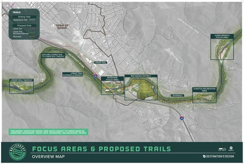


![]()


riverwalk & chestoa pike Bridge
EXISTING CONDITIONS
*Preliminary conceptual design. Final design subject to change based on landowner engagement, survey data, engineering, and regulatory review.

BIRD’S EYE PERSPECTIVE


red banks district
EXISTING CONDITIONS
*Preliminary conceptual design. Final design subject to change based on landowner engagement, survey data, engineering, and regulatory review.

BIRD’S EYE PERSPECTIVE


*Preliminary conceptual design. Final design subject to change based on landowner engagement, survey data, engineering, and regulatory review.

BIRD’S EYE PERSPECTIVE
*Preliminary recommendations dependent upon future hydrological modeling, regulatory review, landowner engagement, survey data, and engineering.

RIVERVIEW & RED BANKS DISTRICT


Expand access to river-based recreation for people of all ages and abilities by developing river accesses and trailheads that promote safe, enjoyable, and equitable experiences. Collaborate with willing landowners and partners to identify opportunities for river access while respecting property rights and community values.
Improve and maintain community parks and open spaces by strengthening public river accesses, expanding greenway and trail connections, and restoring natural habitats.
Expand opportunities for learning about the Nolichucky River’s ecology, history, and recent changes through river-focused education. Support programs that build community awareness, safety, and appreciation for the river corridor.
Enhance the river corridor’s ability to withstand future flooding by restoring natural floodplains, stabilizing eroding riverbanks, and strengthening riparian vegetation.
Promote responsible care of the Nolichucky River corridor by encouraging practices that protect natural resources and support long-term recovery. Engage partners, volunteers, and community groups in efforts that improve river health and ensure its continued enjoyment for all.

1.1 Upper Gorge
1.1.1 Streambank Restoration. Support streambank restoration measures to restore the riparian corridor.
1.2 Jones Branch
1.2.1 Nolichucky Gorge Campground. Support landowner plans to reconstruct campground facilities, including the addition of day-use parking and beach access, and advance implementation of streambank restoration measures to enhance the visitor experience.
1.2.2 USA Raft Adventure Resort. Support landowner plans to reconstruct and enhance resort facilities, including the addition of a riverside viewing area and river-access steps, and advance implementation of streambank restoration measures to enhance the visitor experience.
1.2.3 Appalachian Trail Connectivity. Support maintenance and management of the existing blue-blaze trail connection from Jones Branch Road to the AT by the US Forest Service and Appalachian Trail Conservancy and evaluate opportunities for enhancements to safety, wayfinding, and user experience. Explore wayfinding signage that will highlight connections to existing assets like the Appalachian Trail and Chestoa Recreation Area and planned assets such as the Nolichucky Riverwalk (Erwin Linear Trail Extension) and Red Banks District.
1.2.4 Sewer and Water Extension. Partner with key stakeholders to conduct a feasibility study that explores extending sewer and water service to the terminus of Jones Branch Road.
1.3 Unaka Springs
1.3.1 Road Protection and Improvement. Support measures to stabilize and protect fill embankments, widen roadways and shoulders, install guardrails, and restore streambanks along Jones Branch and Unaka Springs Roads.
1.3.2 River and Streambank Restoration. Support river channel improvements to enhance in-stream navigation and restore the riparian corridor.
1.4 Chestoa
1.4.1 Chestoa Recreation Area. Collaborate with the US Forest Service to support the planned reconstruction and enhancement of the Chestoa Recreation Area, incorporating a public/commercial river access ramp, trailer parking, 6-stall restroom, dumpster, (2) 20’ x 30’ shelters, designated picnic / plaza areas, beach, and a natural surface trail loop.
1.4.2 Appalachian Trail Stewardship and Improvements. Support maintenance and management of the trail by the US Forest Service and Appalachian Trail Conservancy and evaluate opportunities for enhancements to safety, wayfinding, and user experience including signage and a high visibility road crossings on Jones Branch Road to enhance safety, accessibility, and the overall visitor experience.
1.4.3 Appalachian Trail Chestoa Trailhead. Collaborate with the US Forest Service to support the planned reconstruction and enhancement of the Chestoa Appalachian Trail Trailhead to include a two-way loop parking lot with 16 typical parking spaces and a sidewalk spur connecting to picnic tables.
1.4.4 Nolichucky Riverwalk. Develop plans to design and implement the Nolichucky Riverwalk segment between the Appalachian Trail Chestoa Trailhead and the Chestoa Recreation Area, while concurrently advancing streambank restoration measures to enhance the visitor experience and protect riverfront infrastructure.


2.1.1 Chestoa Pike/Appalachian Trail Bridge. Support current plans for bridge replacement by incorporating gateway features, Appalachian Trail branding on both approaches, 10-foot-wide concrete shared-use path, and decorative safety railing to enhance identity, visibility, and the overall user experience.
2.1.2 Intersection Improvements. Design and implement bike and pedestrian improvements at the intersection of Chestoa Pike and River and Unaka Springs Roads to create a safe crossing for the Nolichucky Riverwalk and Appalachian Trail.
2.1.3 Road Protection and Improvement. Support measures to stabilize and protect fill embankments, widen roadways and shoulders, install guardrails, and restore streambanks along River Road.
2.1.4 Nolichucky Riverwalk. Develop plans to design and implement the Nolichucky Riverwalk segment between the Chestoa Pike bridge and Jackson Love bridge while concurrently advancing streambank restoration measures to restore the riparian corridor and protect streamside infrastructure.
2.1.5 Landowner Engagement and Easement Acquistion. Engage landowners along River Road and work towards easement acquisition for the Nolichucky Riverwalk.
2.2.1 Red Banks District Landowner Engagement and Land Acquisition. Conduct outreach to private landowners along Temple Hill Road and gauge interest in potential mixed-use development/redevelopment opportunities to include commercial and residential uses, green space, trailhead, greenway, and trail connectivity.
2.2.2 Business Development. Explore public-private partnerships among landowners and local developers that might be willing to invest in future businesses and infrastructure to realize the vision for the Red Banks District.
2.2.3 Land Acquisition and Conservation. Work with land conservation nonprofits to secure easements and properties of interest along the river to advance implementation of streambank restoration, flood resiliency measures, and park development.
2.2.4 River and Streambank Restoration. Support river channel improvements to enhance in-stream navigation and restore the riparian corridor.
2.2.5 Nolichucky River Park. Collaborate with key stakeholders to implement a riverside park that includes the Nolichucky Riverwalk, river access, fishing access, large group picnic shelters, event stage and open green, restrooms, parking, and streambank restoration.
2.3.1 Blue Ridge Paddling. Support landowner plans to reconstruct and enhance their outfitter facilities including the addition of recreational amenities, RV campground, river access ramp, parking, and pedestrian bridge for the Nolichucky Riverwalk. Support implementation of streambank restoration and flood resiliency measures to protect structures located in the 500 year flood zone.
2.3.2 Erwin Linear Trail. Collaborate with the Town of Erwin and key stakeholders to explore and support Erwin Linear Trail realignment and reconstruction options next to South Industrial Drive.
2.3.3 Trailhead and River Access Area Development. Conduct outreach to private landowners and gauge interest in trailhead and river access area development to serve the Erwin Linear Trail, Nolichucky Riverwalk, and Nolichucky River. Support the creation and implementation of a master plan for the trailhead that includes parking, restrooms, and limited picnic facilities.
3.1.1 Infrastructure Protection and Improvement. I-26 bridges and drainage - bridge extension and high flow channel.
3.1.2 Landowner Engagement and Easement Acquistion. Engage landowners along River Road and work towards easement acquisition for the Nolichucky Riverwalk.
3.1.3 River and Streambank Restoration. Support measures to restore the riparian corridor and redefine the river channel to increase flow and add fish habitat enhancements.
3.2.1 Lower Nolichucky Access Area. Collaborate with Unicoi County and US Forest Service to support the planned reconstruction and enhancement of the Lower Nolichucky Access area, incorporating a public/commercial river access ramp, ADA river access platform, ADA trail, cobble beach, restroom, and parking.
3.2.2 Landowner Engagement. Engage landowners to determine interest in partnering with a local government or nonprofit conservation organization for access area development.


