Daniel Crouch Rare Books Ltd 4 Bury Street, St James’s London SW1Y 6AB +44 (0)20 7042 0240 info@crouchrarebooks.com crouchrarebooks.com
Catalogue edited by Arnie Anonuevo, Daniel Crouch, Rose Grossel, Kate Hunter, Mia Rocquemore and Nick Trimming, Evelyn Unwin Tew, and Katherine Wood. Design by Ivone Chao Photography by Louie Fasciolo and Marco Maschiao Cover: item 9 Terms and conditions: The condition of all books has been described. Each item may be assumed to be in good condition, unless otherwise stated. Dimensions are given height by width. All prices are net and do not include postage and packing. Invoices will be rendered in £ sterling. The title of goods does not pass to the purchaser until the invoice is paid in full.
Frieze Abu Dhabi 2026
The Tabula Rogeriana
1
IDRISI, Al[Tabula Rogeriana] [Nuzhat almushtāq fi’khtirāq al-āfāq - The Book of Pleasant Journeys into Faraway Lands]. Publication [Germany] 1154 [but 1951]. Description Facsimile map on six sheets (560 by 735mm each), printed in colour, additions in gold by hand; title, description and placenames in Arabic. Dimensions 976 by 1986mm (38.5 by 78.25 inches). References Ahmad, “Cartography of al-Sharif al-Idrisi”, The History of Cartography, Vol. 2, Book 1; Amari e Schiaparelli, 1883.
AED 110,000
4
DANIEL CROUCH RARE BOOKS
The map is oriented with south at the top and shows the world from Spain to Korea. A large continent stretches out from eastern Africa, landlocking the Indian Ocean except for the eastern side. Mountains, lakes, rivers and towns are represented, as well as roads and distances. The foremost geographer of his period, Abu ‘Abdallah Muhammad ibn Muhammad al-Sharif al-Idrisi (c1100-1165), was born in Sabta, Ceuta, into a family that claimed rights to the caliphate. He was educated in Cordoba, and travelled widely in North Africa, Europe and Anatolia. In about 1138 the Norman king of Sicily, Roger II, invited al-Idrisi to his court in Palermo, and commissioned him to compile a description of the entire contemporary world. In collaboration with other scholars in Roger’s court, al-Idrisi produced a large circular world map engraved on silver, now lost, and a book, which was to provide the supplementary text. Written in Arabic and accompanied by seventy regional maps and one world map, the book divided the world into seven climates, in keeping with the Ptolemaic system. Each region was thoroughly described in its physical, political, economic and cultural conditions. The book proved to be a great success in the Arabic world, and was copied and translated for centuries. In the western world, it was first printed in Rome in Arabic characters in 1592, then partially translated and published in Latin in 1619. The book served as major tool for Italian, Dutch and French mapmakers from the only ten manuscript copies of the book survive, dating from the early 1300s to the late 1500s; of these, eight contain the maps.
FRIEZE ABU DHABI 2026
A striking map of Arabia from the 1482 Ulm Ptolemy
2
PTOLEMAEUS, Claudius [translated by ANGELUS, Jacobus, edited by GERMANUS, Nicolaus] [Arabia] Sexta Asie Tabula. Publication Ulm, Lienhart Holle, 16 July 1482. Description Woodcut map, fine original hand-colour, old repair to bottom of gutter, minor losses to top gutter skilfully repaired. Dimensions 430 by 590mm (17 by 23.25 inches). References Campbell, T., ‘Earliest Printed Maps’, p. 179-210; Schreiber 5032; Skelton, R.A., Bibliographical note prefixed to the facsimile of the 1482 Ulm Ptolemy.
AED 734,000
8
DANIEL CROUCH RARE BOOKS
The map was published in the first atlas printed outside Italy and the first atlas illustrated with woodcut maps. In 1482 Lienhart Holle in Ulm published a revised edition of Ptolemy’s Geographia with the reworking of the Ptolemaic corpus by the cartographer Nicolaus Germanus Donis. The atlas included five additional “modern” maps: Italy, Spain, France, Scandinavia, and the Holy Land. The atlas would be the first book printed by Lienhart Holle, however, it would appear that the venture proved ruinously expensive and his business would go bankrupt shortly after publication. The remaining sheets, the woodblocks and the types passed to Johann Reger in Ulm, who reissued the work in 1486. As well as the modern maps the atlas bears some other notable first. It was the first time that maps were signed by the artist responsible for the woodcutting; in this case Johannes of Armsheim, who signed the world map, and incorporated a backwards N into the woodcut text on each map. It is also the first to print the accompanying text on the verso of the map to which it refers. Another important feature of the Ulm editions is the introduction of the publisher’s colouring upon the maps. Maps from 1482 usually have a rich blue colour in the sea which was replaced with a soft brown colour in 1486.
FRIEZE ABU DHABI 2026
The first depiction of the “Arabian”gulf
3
MONTALBODDO, Antonio Fracanzano da; translated into Latin by Archangelo MADRIGNANO Itinerarium Portugallensium e Lusitania in Indiam & inde in occidentem & demum ad aquilonem. Publication [Milan, Giovanni Angelo Scinzenzeler], 1508. Description Folio (276 by 195mm). Letterpress titlepage with large woodcut map, vignette star charts and initials; contemporary panelled blind-stamped vellum over boards, decorated in blind, gilt lettering-piece on the spine, remains of two pairs of clasps and catches. Collation: A8, aa2 (index), B-C8, D6, E-F8, G6, L-M8, N6; leaves 98: foliation [10], LXXVIII (leaf XIX misfoliated XVII, leaf XLVII misfoliated XLVI, leaf LII misfoliated LI, leaves LX and LXI unfoliated, leaf LXXXIIII misfoliated LXXIII). References Alden and Landis, 508/4; Borba de Moraes, I:580; Brunet, III:474; Church, 27; Cooper, ‘The Library’, 4th series, iii, (1922-23), page 53-54; Fumagalli, 985; Harrisse [Discovery], 58; Hattendorf, 111; Németh, 175-198; Quarrie for ODNB online; Sabin, 50058; Streeter, 3.
AED 2,690,000
10
DANIEL CROUCH RARE BOOKS
The Henry Huth - James C. McCoy copy of the first printed collection of voyages; the earliest mention of the ‘Arabian’ gulf; and, “after Columbus’s letter, the most important contribution to the early history of American discovery”. A magnificent example, with a superb provenance, of the extremely rare first edition in Latin of the first printed collection of voyages, written by Fracanzano da Montalboddo, and considered “after Columbus’s letter the most important contribution to the early history of American discovery” (Sabin). The work was first printed in Italian in 1507 under the title ‘Paesi novamente retrovati’, and it was translated into Latin the following year by the Milanese monk Arcangelo Madrignano, after which it quickly became “the most important vehicle for the dissemination throughout Renaissance Europe of the news of the great discoveries both in the east and the west” (PMM). With the woodcut map, which appears for the first time in this Latin edition, is the first large map of Africa, the first known map in which that continent is depicted as surrounded by the ocean, as well as the earliest “modern” printed map to show Mecca. This is the second issue, distinguished by naming The Gulf as ‘Sinus Arabicus’, as opposed to ‘Persicus’. Also with the rare two-leaf index, which is of crucial importance to the ‘Itinerarium Portugallensium’ as it gives an outline of the subsequent contents, identifying individual voyages and discoveries, whereas the text of the book runs continuously from section to section without distinguishing where a new one begins. These leaves were apparently printed after the publication of the work, and so inserted into the few available copies after the fact, and are therefore almost invariably missing. The work, which contains six nominal sections, commences with the 1456 voyages of Alvise de Cadamosto in Ethiopia and along the West African coast, which appeared for the first time in this work. Cadamosto traveled to Senegal, Gambia, and the Cape Verde Islands in 1455 and 1456. This is followed by accounts of: Pedro de Sintra’s expedition along the west coast of Africa as far as Sierra Leone in 1462; Vasco da Gama’s epochal voyage to Africa and India (1497-99), which “opened the way for the maritime invasion of the east by Europe” (PMM), supplied by letters from Venetian spies in Portugal; and Pedro Alvares Cabral’s discovery of the Brazilian, Guianaian and Venezuelan coasts in 1500. The third section is a continuation of the Cabral narrative of the voyage on to India. The fourth is an account of Columbus’s first three voyages (1492-1500), undoubtedly based on Peter Martyr’s ‘Libretto de tutta la navigatione de Re de Spagna de le isole et terreni novamente trovati’, as well as narratives of the expeditions of Alonso Niño and Vicente Yañez Pinzon along the northern coast of South America. The fifth is Vespucci’s letter to Lorenzo
FRIEZE ABU DHABI 2026
de’ Medici describing his third voyage in 1501-1502. The sixth is a compilation of information derived from several sources concerning the Portuguese discoveries in Brazil and the East. Montalboddo’s collected voyages, called by Henry Harrisse “the most important collection of voyages”, and asserted by Boies Penrose that “for news value as regards both the Orient and America, no other book printed in the sixteenth century could hold a candle to it”, was the forerunner of the later compilations of Grynaeus and Huttich, Ramusio, Eden, Hakluyt, the De Brys, and Hulsius, “an auspicious beginning to the fascinating literature of the great age of discovery” (Lily Library online). Provenance 1. Early ink library stamp of ‘Bibliothecte Monasterii’ on the map; 2. Henry Huth (1815–1878), collector of Americana, his sale Messrs. Sotheby, Wilkinson & Hodge, The Fiftieth Day, 11th July, 1919, lot 7731, morocco, gilt library label on the inside front cover; 3. James Comly McCoy (1862-1934), collector of Canadiana and French Americana, morocco, gilt library label on the inside front cover; 4. With Sotheby’s 10th November, 1959. From the distinguished libraries of two titans of the book collecting world: Henry Huth (1815-1878) From an exceedingly wealthy family, Huth shunned a career in the Indian Civil Service, and instead joined the family banking firm. His “interest in old books went back to his schooldays, and he was said to have been fired with enthusiasm by seeing “a curious old book” in Baldock’s Holborn bookshop. In Mexico in 1840 he acquired a number of rare Spanish books and a Chinese Bible from a man who stopped him in the street, but it was in the later 1840s that he began collecting in London with his brother Louis (d. 1905) from whom he bought a copy of the 1512 Burgos edition of the ‘Cronica del Cid’. Louis later became a well-known collector of oriental porcelain. In 1852 Huth met the bookseller Joseph Lilly, who exercised a good deal of influence on his purchases over the years and was generally his agent, but Huth bought throughout the trade and made it his practice on his way from the City to his home at 30 Princes Gate, London to stop at a number of leading booksellers. Books of American interest he acquired from Henry Stevens of Vermont. Several of his grandest purchases were through Bernard Quaritch, including, in 1874, a copy of the 42-line Bible of Johann Gutenberg (Mainz, c.1455) which had been bought at the sale of the Perkins library from Hanworth Park in 1873. From Quaritch also, and from the same sale, he obtained the magnificent 1462 Fust and Schoeffer Bible on vellum... In the late 1860s 12
DANIEL CROUCH RARE BOOKS
FRIEZE ABU DHABI 2026
Huth conceived the idea of a catalogue of his collection, a work he began himself, but which from 1871 was worked on by Hazlitt and F. S. Ellis, though Huth himself read the proofs. The work lasted some years, eliciting adverse remarks from Huth about its cost, and he did not live to see its completion in five volumes in 1880. Huth was found dead on 11 December 1878, having had a stroke on the stairs of his house at 30 Princes Gate, and fallen backwards, fracturing his skull. His wife and family were away for the weekend and he was believed to have died the previous day. His son Alfred took over the care of the collection, which was finally sold by Sotheby, Wilkinson and Hodge between 1911 and 1920, raising over £350,000. Before the sale the British Museum was allowed to select fifty volumes. Of the remaining books many found their way into the British Museum’s library and other institutional libraries, especially in the United States” (Quarrie). James Comly McCoy (1862-1934) Once described erroneously by F.D. Cooper, in a review, as “a rich American living in Paris”, he in fact lived for much of his life in Graesse. However, McCoy was rich enough to acquire a considerable and important library of books related to the Jesuits in North America, about which he, and others, wrote: ‘Canadiana and French Americana in the library of J.C. McCoy: a hand-list of printed books from 1508 to 1928’ (1931); ‘Jesuit Relations of Canada, 1632-1673. A Bibliography’ (1937).
14
DANIEL CROUCH RARE BOOKS
FRIEZE ABU DHABI 2026
The first printed sea-chart of the world
4
[ROSSELLI, Francesco]. [Untitled Carta Marina]. Publication [Florence, c.1508]. Description Double-page engraved chart, printed from two copper-plates on separate sheets, joined, with contemporary colour wash in part. Dimensions 201 by 386mm (8 by 15.25 inches). References Bifolco, ‘Cartografia e Topografia Italiana del XVI Secolo’, 7; Boffito and Mori, ‘L’inventario Rosselli’, in ‘Piante e vedute di Firenze: studio storico topografico cartografico’, Appendix II: 146-150; Museo Galileo, ‘A Land Beyond the Stars’, online; Metcalf, ‘Mapping an Atlantic World’, 2020; Shirley, ‘The Mapping of the World’, 29.
AED 3,668,000
Rosselli’s exceptionally rare sea-chart of the world is the first such printed, heralding the arrival of a new brand of utilitarian global cartography, changing the lives of navigators and mariners immeasurably, and forever; and eventually superseding the production of the great planispheres of the Age of Discovery, for recording the discovery of new territories. These expansive, and ever-expanding maps, composed of multiple animal skins, had developed from early, smaller single skin, sailing charts or portolans. These had been in use from potentially as early as 1200, although the earliest surviving example is the ‘Carte Pisane’ (c.1290). These, largely undecorated charts were intended for use aboard ship, they saw hard service and had short lives. Rosselli’s chart takes great pains to combine the elements of both its humbler manuscript portolan, and grand planisphere predecessors, in many ways. It is compact and portable in size, replete with rhumb lines radiating from a single compass point at the heart of the map, but that is surrounded by a further symmetrical ring of compass points, which extend the sweep and scope of the chart, quite literally, to all four corners of the earth. Cartography The Americas Centred on the, yet unnamed, Atlantic Ocean, Rosselli’s chart is divided down the middle by the prime meridian, which runs through the Canary Islands, pole to pole, 90 degrees to 90 degrees. Rosselli has adopted the cartography expressed in the celebrated “Contarini” map of the world, known in only one example, at the British Library (Maps C.2.cc.4.). Named for its creator, Giovanni Matteo Contarini, that map uses a Ptolemaic conical, fan-shaped, projection, but it was engraved by none other than Rosselli himself, only two years earlier, in 1506 - when it was the first printed map to show the New World. In the years after Columbus first made landfall in Hispaniola (1492), Vasco da Gama had reached India by sea (1498), and Cabral had landed in Brazil (1500). And Columbus had made three more voyages: the second voyage (1493-1496) encompassed the Antilles, Santo Domingo, Cuba (which he thought was Cathay/China), and Jamaica; the third voyage (1498-1500), took his fleet to the coast of Venezuela, and the delta of the Rio Grande de la Costa; and the fourth voyage (1502-1504), explored the coasts of Jamaica, Cuba, Honduras, the Mosquito Coast of Nicaragua, and Costa Rica. The Americas feature prominently on Rosselli’s chart, and as with the Contarini map, it is updated to include the discoveries of Columbus’s fourth voyage (1502-1504). Columbus’s discoveries in the West Indies are shown: Spagnola features large, and Cuba is shown as an island. However, unlike the companion map, only South America, labelled “Terra S. Crucis”, is shown as a separate new continent - albeit with a rather tentative
16
DANIEL CROUCH RARE BOOKS
FRIEZE ABU DHABI 2026
western and southern coastline - while North America, labelled “Tyerra de Labrador”, remains firmly attached to the Asian peninsula of “Tangut Provincia...”, part of the Ptolemaic oikumene of Europe, Africa and Asia, helping to explain why Columbus, sailing west of Cuba, believed he had arrived at China. A Southern Continent An unnamed southern continent, lacking a southern coastline, appears in the ocean beneath Africa - named on the companion map as “Antarcticus” - and as such is one of the earliest maps to deviate from the Macrobian model of a southern continent. The first printed spherical map to show a southern landmass had appeared in the 1483 printing of Macrobius’s ‘In somnium Scipionis expositio. Saturnalia’. The Macrobian world map, the most influential of all pre-Renaissance views of the world, included an antipodean, southern continent. This woodcut map, like Vespucci’s, shows a globe split into two - Europe and the balancing Antipodes - and surrounded by ocean at the edges. This remarkable image, which survived by manuscript transmission from the fifth century into the age of printing, had a strong and lingering effect on post-Renaissance and pre-discovery geography. Its large southern continent carries the legend ‘Pervsta / Temperata, antipodum / nobis incognita’. For a thousand years the Macrobian world map formed the basis of world geography, until Renaissance exploration replaced it with discovered fact, and all pre-discovery mapping was to some extent based on it, as were all ideas of a southern hemisphere, a southern continent, or an antipodes. Fit for an Atlas? Around the middle of the fifteenth century, cartographers began to experiment with incorporating recent discoveries into another cartographic medium, the ‘Geography’ of Claudius Ptolemy. In Rome, in 1507, the third printed edition of Ptolemy’s Geography was published. Reprinting of the copperplate maps of the 1478, and 1490 editions, this new atlas was superior for its clear captions, accurate projections and overall design. And, it included Johann Ruysch’s (1460-1533) version of the Contarini map, ‘Universalior Cogniti Orbis Tabula’. Although the cartography has been updated, the format remains that of a fan-shaped conic projection. It is not hard to imagine that Rosselli may have been aware of Ruysch’s map, and its relationship to his own and Contarini’s earlier great work, giving rise to feelings of indignant proprietorship,... possibly spurring the production of this, Rosselli’s more original imagining of the modern planisphere, and his, unique for the time, companion map of the world on an oval projection - the very first on such a projection, and the first to attempt to show the whole world within a grid of 360 degrees longitude, and 180 degrees latitude. One of the only four known examples of that 20
DANIEL CROUCH RARE BOOKS
FRIEZE ABU DHABI 2026
map is found as part of a contemporary pairing with Rosselli’s planisphere at the National Maritime Museum at Greenwich (G201:1/53). Perhaps Rosselli’s intention had been to issue a modern atlas of his own (the size of the mapsheet certainly corroborates this idea), an ambitious plan that foundered after the production of just these two maps, in the face of competition from rivals such as Marco Beneventano in Rome, who had issued his Ptolemaic atlas in 1507, and Bernardus Sylvanus in Venice, who would issue his updated atlas in 1511. The mapmaker Francesco Rosselli (1445-1513), who was one of the earliest known mapsellers, was active in Florence up to his death. Francesco’s son, Alessandro Rosselli, continued his father’s workshop, until his own death in 1527, when “an inventory was taken of the shop, [which] document provides historians with insights into the workshop of an early sixteenth-century chart and mapmaker. The Rosselli shop specialized in the printing and engraving of maps and town plans, but many other kinds of maps and charts are listed in the inventory, including small painted mappaemundi, decorated and plain portolan charts, and some charts composed from several pieces of parchment. Among the maps mentioned in the inventory is a large mappamundi, a map of India, a map of Italy, and city maps of Florence, Rome, and Constantinople. The inventory also includes supplies and books of drawings” (Metcalf ). Rarity Only two other examples known, one at the Biblioteca Nazionale Centrale, Florence; and the National Maritime Museum, Greenwich.
FRIEZE ABU DHABI 2026
DANIEL CROUCH RARE BOOKS
21
The most important maps of the Middle East and Arabia published in the sixteenth century
5
GASTALDI, Giacomo & LAFRERI, Antonio
AED 611,500
Fine examples of the most influential sixteenth century maps of Central Asia and the Middle East, by Giacomo Gastaldi, the greatest cartographer of his era. Not only are these works the most accurate depiction of the area to date, but would go on to dominate the European view of the area for the rest of the sixteenth century. Giacomo Gastaldi (c1500-1567), originally from Piedmont, established himself as a cartographer in Venice, where he was given the notable title of ‘Cosmographer to the Republic’. He was a prolific mapmaker, with a body of work numbering at least 109 pieces, including contributions to the 1548 Venice edition of Ptolemy’s ‘Geogra a’, and Ramusio’s ‘Navigationi et viaggi’. Gastaldi’s maps of Asia are considered amongst the most significant representations of the continent, as the first pieces of cartography to name, and even show, many of the areas depicted. They were also responsible for numerous features which would later become standardised, such as the ovalized Caspian Sea. Originating from Venice, the maps are also a reflection of the Republic’s dominance of early exploration, particularly in Asia. The city’s crucial position allowed for Western contact with the East, although this relationship was becoming progressively threatened by the expansion of the Ottoman Empire. The first part of Asia, here in its first state by Lafreri, is based on Gastaldi’s map of 1559. Although Lafreri had permission to print and sell Gastaldi’s original maps, this map was made from a re-engraving by Jacopo Bos, perhaps because of damage to the original plates. Bos’ work is very similar to that of Gastaldi’s own engraver, Fabio Licinio, with stylistic differences in the waters and ships revealing the new engraver’s hand. It has been suggested that Bos engraved this edition for the Roman publisher Michele Tramezzino, and that only later did Lafreri acquire the publishing rights (Witcombe). The second part is here in its first state and was engraved by Licinio. The upper part repeats some areas of the previous map, however the two were intended to form one, as shown by the identical scale bars and projection. Together the two parts extend from southern Siberia to the Indian Ocean, encompassing huge swathes of the continent. They cover Turkey, the Middle East, the Black and Caspian Seas, the Eastern Mediterranean with Cyprus, the stream of the Nile and the whole of the Arabian Peninsula, with part of Western India and the Maldives. The coastal and island names, as noted by Nordenskjöld, are taken from portolans and from voyages of Spanish and Portuguese exploration. Some interior names are taken directly from Marco Polo and almost identical in orthography to those used by Ramusio. The abundance of toponyms suggests further sources,
22
FRIEZE ABU DHABI 2026
La descrittione della prima parte dell’Asia. [and] Il disegno della seconda parte dell’Asia. Publication [Rome and Venice respectively, 1561]. Description Pair of engraved maps, each on two sheets joined, watermark of ladder in shield under six-pointed star (Woodward 253), to all four sheets. Dimensions 495 by 795mm (19.5 by 31.25 inches) 450 by 780mm (17.75 by 30.75 inches) References Bifolco 68 state 1, and 71 state 1; Nordenskjöld, pp. 396-406, The Geographical Journal vol. 13, April 1899; Schilder p.7, The Map Collector 17, December 1981; Suárez, The early mapping of Southeast Asia, pp.130-157, 1999; Tooley pp.20, 21; Witcombe 234, 2008.
DANIEL CROUCH RARE BOOKS
which Gastaldi may have accessed in the large library of the Fugger family. Markus Fugger, a prominent businessman and politician, was among the cartographer’s acquaintances, and the second part of Asia is dedicated solely to him. Importantly, Gastaldi’s maps of Asia provided the basis for those later published by Ortelius, De Jode and Mercator. Bifolco records 33 examples of the first map held in institutions, and 42 of the second, but both are rare on the market. We have been able to trace only four examples of the first, and seven of the second, appearing at auction in the last 50 years.
24
DANIEL CROUCH RARE BOOKS
FRIEZE ABU DHABI 2026
Gastaldi’s seminal map of Southeast Asia
6
GASTALDI, Giacomo’ Paolo FORLANI; and Ferrando BERTELLI Il disegno della terza parte dell’Asia. Publication [Venice, 1562 and c1568]. Description Engraved map on three sheets joined, bearing three watermarks, upper left sheet with ladder in shield under cross pommy B (Woodward 256), upper right with lamb, paschal with straight standard C (Woodward 48), lower sheet, only lower half of ladder in shield under six-pointed star K (Woodward 253). Dimensions 680 by 775mm. (26.75 by 30.5 inches). References Bifolco 74 state 2; Nordenskjöld, pp. 396406, The Geographical Journal vol. 13, April 1899; Schilder p.7, The Map Collector 17, December 1981; Suárez, The early mapping of Southeast Asia, pp.130-157, 1999; Tooley pp.20, 21.
AED 611,500
26
DANIEL CROUCH RARE BOOKS
A fine example of Gastaldi’s map Southeast Asia, the most influential map of the region published in the sixteenth century, and the first map to name Singapore; here present with the rare southern extension sheet, incorporating the Java and the lucrative Spice Islands. Giacomo Gastaldi (c1500-1567), originally from Piedmont, established himself as a cartographer in Venice, where he was given the notable title of ‘Cosmographer to the Republic’. He was a prolific mapmaker, with a body of work numbering at least 109 pieces, including contributions to the 1548 Venice edition of Ptolemy’s ‘Geogra a’, and Ramusio’s ‘Navigationi et viaggi’. Gastaldi’s maps of Asia are considered amongst the most significant representations of the continent, as the first pieces of cartography to name, and even show, many of the areas depicted. Originating from Venice, they also reflect the Republic’s dominance of early exploration, particularly in Asia. The city’s crucial position allowed for Western contact with the East, although this relationship was becoming progressively threatened by the expansion of the Ottoman Empire. The present map bears the same scale bar as Gastaldi’s first and second parts of Asia, and matches with their latitudes and longitudes. It has been dubbed the most influential map of the region published in the sixteenth century and, as noted by Schilder, ‘in the representation of the coastlines, his maps are superior to all previous known maps of Asia, either drawn by hand or printed’. After Gastaldi’s death, it was augmented by two further sheets, as in the present example, narrower in size, and with the imprint ‘To be sold at the San Marco bookshop in Venice’ (transl.). The map extends from central Asia to China and is particularly important for its depiction of the islands below the Equator. Alongside the Moluccas, labelled the “Isole di Ambon”, Gastaldi includes a note explaining that “in these islands there are cloves, cinnamon, nutmeg, pepper, sandalwood, ambergris, and many spices” (transl.), reflecting the importance of these resources to Venetian trade. e Philippines appear as “Philippina” and Borneo in its present nomenclature; found below these is Java, labelled “Giava Magiore” to distinguish it from the fictitious “Giava Minore” added by Forlani. Significantly, this is the first map to name Singapore and Cambodia.
FRIEZE ABU DHABI 2026
Gastaldi’s sources vary from Venetian explorers, such as Marco Polo and Pigafetta, to the records of Spanish and Portuguese voyages, most notably that of Magellan. As noted by Nordenskjöld, it is likely that he had access to the extensive library of the Fugger family, since Marcus Fugger was an acquaintance and the sole dedicatee of this map, as well as to the maps in the Sala dello Scudo, which he was commissioned to paint, thanks to his close connection with the Venetian Secretary of State. Gastaldi’s maps set a new standard in cartographic representations of Asia, and formed the basis of those subsequently published by Ortelius, De Jode and Mercator. Although Bifolco records 41 examples of this map held in institutions worldwide, this map is extremely rare on the market. We have been able to trace only two examples appearing in the last 50 years.
28
DANIEL CROUCH RARE BOOKS
FRIEZE ABU DHABI 2026
“The navigator’s vade mecum for the Eastern seas” - one of the most influential English travel books of the sixteenth century
7
LINSCHOTEN, Jan Huygen van John Huighen van Linschoten his Discours of Voyages unto ye Easte & West Indies. Devided into Foure Bookes. Publication London, John Wolfe, 1598. Description 4 parts in one volume. Folio (290 by 190mm), mostly black letter, double column. [6] leaves, blank, engraved general title-page by William Rogers (Johnson, p.2, Rogers no.3), dedication, ‘To the Reader’, pages numbered 1-197 ‘The First Booke’, [1] leaf sectional vignette title-page with engraved map of the Congo, pages numbered [197]- 259 (ie 295) ‘The Second Booke’, [1] leaf sectional vignette titlepage with engraved double- hemisphere map of the world, Shirley 182, pages numbered 307- 447 ‘The Thirde Booke’, [1] leaf sectional vignette title- page with engraved map of Spain, pages numbered [451]-462 ‘The Fourth Booke’; doublepage engraved folding map of the world ‘Typus Orbis Terrarum’ (Shirley 169), 8 large double-page folding maps, and 3 folding views of St. Helena and Ascension, 4 woodcut maps in text, woodcut initials, factotums and head-piece ornaments; EXTRA-ILLUSTRATED with 29 plates by the van Deutecum brothers from the Dutch edition, some minor reinforcement at some of the folds, otherwise a fine crisp example; full calf, five line gilt panelled boards, spine with raised bands, each compartment with similar gilt panels, gilt titles. Collation: A(4), B-I(6), K-Q(6), R(8), *s(2), S-U(6), X-Z(6), Aa-Ii(6), Kk-Pp(6), Qq(7) 280 by 188mm. (11 by 7.5 inches). References Alden and Landis, 598:57; Borba de Moraes, I:417; Church, 321; ESTC, S111823; Hill, 182; Howgego, L131, G40; Luborsky and Ingram, 509; Parker, 159-161; Sabin, 41374; Schilder, 195-228; Shirley [World], nos. 167 and 216; Shirley [Atlases], G.Lin 2a; Streeter Sale, 1:31; Worms, 1705; Worms and Baynton-Williams.
AED 734,000
30
DANIEL CROUCH RARE BOOKS
The very rare English edition of Linschoten’s ‘Itinerario’, first published in Dutch in 1595-1596, and translated from the Dutch by William Phillip. Linschoten’s was the first printed work to include precise sailing instructions for the East Indies. Its exposition of a route to the south of Sumatra through the Sunda Strait allowed Dutch and, later, English merchants to circumvent the Portuguese stranglehold on passage, and, therefore, trade, to the East through the Straits of Malacca. This enabled the British East India Company and the Dutch East India Company to set sail for the Spice Islands and, ultimately, China and Japan, and was of such economic utility that, according to Church, and others, “it was given to each ship sailing from Holland to India” and soon became “the navigator’s vade mecum for the Eastern seas” (Penrose). “This important work contains all the knowledge and learning related to the East and West Indies and navigations to those parts that was available at the end of the sixteenth century. It was held in such high esteem that for nearly a century a copy was given to each ship sailing to India as a guide to the sailing directions. The fact that most copies were in continual use is in no doubt the reason that fine copies, especially with all correct plates and maps, are so very rare” (Hill). The work is made up of four parts. The first, provides the account of Linschoten’s travels in Asia and includes accounts of the east coast of Africa, Arabia, and as far east as Japan. The chapter is accompanied by fine folding maps of the world, Arabia and India, the southeast coast of Africa, a superb map of east Asia and the East Indies and finally one of southwest Africa. The second book focuses on the west coast of Africa, around the Cape of Good Hope to Arabia and India. It also details the New World accompanying which is a fine map of South America extending northwards to Florida. The third book is derived from the discoveries of the Portuguese Royal pilot Diego Affonso, and details the navigation from Portugal to India, and onwards to the East Indies. Similar detail is also provided for Spanish America and Brazil. Accompanying this is the superb “Spice Islands” map illustrated with spices of the region. The final fourth book provides economic details provided by the territories of the King of Spain. In fact, until its publication, no other book contained anything like the amount of useful information on the East and West Indies, and it soon became required reading for all navigators sailing to the East, with chapters on the coast of “Arabia Felix”, ie., the southern coast of the Arabian peninsula, the island of Ormus, and Islamic India. “This is the first work outside of Portugal and Spain to provide detailed practical information on how to get to and engage in trade with America and India. The work was indispensable to sailors on the route to the Indies [and] served as a direct stimulus to the building of the vast English and Dutch overseas empires” (Streeter).
FRIEZE ABU DHABI 2026
Jan Huyghen van Linschoten (1563-1611) Linschoten was a native of Enkhuizen who travelled to Spain in 1576 to join his two elder brothers. The family moved to Lisbon during the troubles of 1581. Through family contacts the young Linschoten became attached to the retinue of Vincente de Fonseca as he was sent to Goa as Archbishop. Arriving in September 1583 he spent time travelling through Malabar and Coromandel. All the while he compiled a secret account of his findings. In 1586 Dirck Gerritsz (1544-1604) passed through Goa returning from Japan having also been to China. He was probably the first Dutchman to visit the former. He passed much of his knowledge to Linschoten. The archbishop returned to Europe in 1587 to report to Philip II but Linschoten remained. Expecting his return, he later found out that he had died at sea. He resolved to return himself and through the auspices of Dutch traders such as the Fuggers and Welsers in India obtained the position of a factor on one of their returning vessels in 1589. He remained on the island of Terceira in the Azores for two years and made his way back to Holland in September 1592. He continued to gather further information from Dutch sailors even accompanied William Barentsz’s second voyage to the Kara Sea in 1594-95. In 1594 he received permission to publish his work. The ‘Itinerario’ was an instant success and combined his firsthand accounts with translations of Portuguese and Spanish documents. The work provided accurate sailing information and detailed descriptions of how to trade in both Asia and South America and the nature of their commodities. Legend has it that examples were given to every Dutch ship sailing to Asia. Translation Word of the significance of the book reached the publisher John Wolfe (fl.1579-1601) who records in the dedication: “About a Twelvemonth agoe, a learned Gentleman brought unto mee the Voyages and Navigation of John Huyghen van Linschoten into the Indies written in the Dutche Tongue, which he wished might be translated into our Language, because hee thought it would be not onley delightfull, but also very commodious for our English Nation. Upon this commendation and opinion, I procured the Translation thereof accordingly, and so thought goo to publish the same in Print...’. That gentleman was identified in the address to the reader: ‘Which Booke being commended, by Richard Hackluyt, a man that laboureth greatly to advance our English Name and Nation”. Wolfe was ideally placed to undertake the work, being “the first London bookseller to produce a sequence of map-illustrated works. He clearly kept a rolling-press and was possibly the first regular London book-printer to do so” (Worms & Baynton-Williams). The translation was undertaken by William Phillip. The maps and plates were engraved 36
DANIEL CROUCH RARE BOOKS
FRIEZE ABU DHABI 2026
by Robert Beckit, Ronald Elstrack and William Rogers. Most are re-engravings of those in the Dutch edition. “Wolfe’s turbulent career, his clashes with his old master John Day and the Stationers’ Company, his imprisonments, secret presses, and faked imprints have sometimes obscured his other achievements. He had an extensive international trade and was ‘the father of news publishing’ in London” (Worms). “Financial help came from a group of London merchants who provided ten pounds to Hakluyt to see the book in print alongside a further thirty shillings towards the production of maps to accompany it” (Parker). Extra illustration This is a slightly taller example than the Church copy. The English edition did not include copies of the thirty or so illustrations of native peoples found in the Dutch edition. However, ‘sets of the Dutch engravings were apparently imported by the publisher and bound into some exemplars’ (Luborsky & Ingram), as found in this example. Examples do vary in content and some are found with examples of the Dutch maps inserted. Indeed, the British Library possess three examples, none are complete. This example only includes the English engraved maps. List of maps Most of the maps and views of the English edition are re-engravings of the plates of the original Dutch edition of 1595-1596, with captions in Latin and English. 1. [Anonymous after] ORTELIUS, Abraham, ‘Typus Orbis Terrarum’. An English derivative of Ortelius’ more up to date plate of 1587 and the earlier more decorative cloud border. Shirley (1993) 167. 2. [Mozambique], ‘The description of the Islandes and Castle of Mozambique...’, engraved by William Rogers. 3. [Arabia, the Indian Ocean and India], ‘The description of the coast of Abex...’ A much-improved depiction of the Arabian Peninsula. Al-Qasimi (1999) p. 32 Dutch edition only; Ankary (2001) pp. 74-6, 148-9 referring only to the Dutch plate; Gole (1978) no. 8 listing only the Dutch plate; Schilder (2003) pp. 220-3; Tibbets (1978) no. 51: “The surprising fact about the representation of the [Arabian] peninsula is the close resemblance of the outline to that of a modern map when compared with other engraved maps of the time. There is a vague suggestion of the Qatar peninsula, which is not seen again until the nineteenth century” (Tibbets).
40
DANIEL CROUCH RARE BOOKS
FRIEZE ABU DHABI 2026
4. [East Africa], ‘The description or Caerd of the Coastes of the Countreys following called Terra do Natal...’, engraved by Robert Beckit, including the western half of the Indian Ocean along the coast of South Africa, all of Madagascar. 5. [Southeast Asia], ‘The Trew Description of All the Coasts of China...’, extending from the island of Korea and Japan south of ‘Beach’ (Australia), Java, Timor, the Philippines, the Indochina peninsula, and most of the coast and much of the interior of China), Chang (2003) pl. 16, p. 147 Dutch only, p. 192 no. 134 English; Geldart (2017) p. 19; Hubbard (2012) p. 47, fig. 36; Schilder (1976) no. 18 Dutch; Schilder (2003) pp. 222-6; Suarez (1999) pp. 178-9; Suarez (2004) p. 79; Walter (1994) no. 12 Dutch. 6. [St. Helena] a. ‘The Island of St. Helena full of Sweet and pleasaunt ayre fructfull ground and fresh water...’, b. ‘The true description, and situation of the Island St. Helena, on the East, North, and West Sydes’, both engraved by Raygnald Elstrak. 7. [Ascention Island], ‘The True Description of the Island of Ascention...’, engraved by William Rogers. 8. [Southwest Africa], ‘The description of the Coast of Guinea...’. Norwich (1983) no. 239a Dutch; Schilder (2003) pp. 215-19; Tooley (1969) p. 67 Dutch. 9. [South America], ‘The description of the whole coast lying in the South Seas of Americae called Peru...’, displays the whole of South America, Caribbean and Florida. Schilder (2003) pp. 226-8. 10. [The Spice Islands Map], ‘Insulae Molucca celeberrimae...’, extends from southeast Asia to the Solomon Islands and northwards to include the Philippines. The famous Spice Island map, so called for its depiction of the spices nutmeg, clove, and sandalwood along the bottom after the original by Petrus Plancius who obtained his information covertly from the Portuguese maps of Bartolomeu Lasso. Schilder (2003) pp. 117-22; Suarez (1999) pp. 177-9.
42
DANIEL CROUCH RARE BOOKS
FRIEZE ABU DHABI 2026
Dudley’s original manuscript manual for the use and instruction of the officers of the Tuscan fleet
8
DUDLEY, Robert; and others Direttorio Marittimo di Don Roberto Dudleo Duca di Northumbria fatto p[er] ordine del Ser[issimo]Gr: Duca di Toscana suo Sig[no]re e diviso in due Tomi et ogni Tomo in due libri co[n] suoi Capitoli. Publication [Firenze, c1637-1647]. Description Folio (290 by 196mm). Original working autograph and holograph manuscript, in Italian, illustrated throughout with diagrams, and drawings of instruments, on seventeenth-century Italian paper, with various watermarks including a Sun (similar to Heawood 3893) and a Medici Coat-ofArms (similar to Heawood 786), extensively revised at the time, some pages edited with paste-overs, others excised; early drab Italian stiff paper wrappers, stabbed and sewn as issued. Collation: 282 pages, foliated in pencil; pages [i-iv] bio-bibliography by Domenico Maria Manni; 1: title-page; 2: additional draft title-page, and dedication; p3-14: prospectus of contents (cancelled), followed by autobiographical ‘Proemio’; p15-139: ‘Direttorio Marittimo’, revised texts of 28 chapters of ‘Dell’arcano del mare’, incorporating theological ‘Proemio’, pp39-40; p140-146 addenda. Condition: a few leaves missing between folios 86 and 87 (chapter xix and the beginning of xx), some lower margins trimmed, occasionally crossing the text References R. Dudley, Dell’Arcano del mare, 6 books in 3 volumes, Florence, 1646-1647; Dell’arcano del mare, second edition, Florence, 1661; Arthur Gould Lee, The Son of Leicester, the Story of Sir Robert Dudley, London, 1964; J. T. Leader, Life of Sir Robert Dudley, Florence, Barbera, 1895; J. F. Schutte, S. J., ‘Japanese Cartography at the court of Florence; Robert Dudley’s maps of Japan, 1606-1636’, in Imago Mundi (23), 1969, pages 29-58; Giovanni Targioni-Tozzetti, Notizie degli aggrandimenti delle scienze fisiche accaduti in Toscana nel corso di anni LX. del secolo XVII, 3 volumes. Florence, 1780; Manoscritti e alcuni libri a stampa singolari esposti e annotati da Pietro Bigazzi. Firenze, Tipografia Barbera, 1869.
AED 1,467,000
44
DANIEL CROUCH RARE BOOKS
The only known manuscript example of any part of Robert Dudley’s magnum opus, ‘Dell’arcano del mare’ held in private hands. An astonishing survival: a working manuscript, seemingly specifically assembled for the eyes and instruction of the officers of the Tuscan Navy, the Knights of St. Stefano, rather than for a public audience. This suggestion is borne out by the wording of the first title for the work that Dudley has crossed out (page 2): ‘Compendio del Direttorio Marittimo: Il pr[im]o Tomo e intilato, Supplemento della Navigare. Nel pr[im]o libro si discorre dell ‘arte, piu Curiosa di Navigare...’. This was also the theory of Sir John Temple Leader, previous owner, and Dudley scholar: “It seems probable that the Arcano del Mare was only a resume of several previous works by Dudley. One of them is the MS. volume, quarto size, of which I possess the original, mostly in Dudley’s own hand. It is called the ‘Direttorio Marittimo’, and was written in very faulty Italian for the use and instruction of the officers of the Tuscan fleet. In it most of the subjects enlarged upon in the Arcano, are treated concisely, including great circle sailing and all kinds of navigation ; the administrative management of a fleet, and its manoeuvres in a naval battle, etc. The book is in ancient covers of thick paper, and preceded by a dedication to the Grand-Duke, and by a sketch of Dudley’s own naval life, written in his own hand with all his corrections and underlinings” (Leader, page 19). Leader acquired the ‘Direttorio’ from Florentine librarian, collector, and bookseller, Pietro Bigazzi, from who he also acquired Gian Carlo de’ Medici’s (1611-1663), first edition of ‘Dell’Arcano del mare’, and a second edition, too. Leader writes about all three works, and the story of their acquisition, in his ‘Life of Sir Robert Dudley’ (1895). The texts of the ‘Direttorio’ have clearly been written by Dudley, over time, but from at least as early as 1643-1644, and are further annotated by him up until 1647 (he died in 1649), and then further annotated by others, up until the publication of the second edition of 1661. They include: Dudley’s autobiography, in which he sets out his credentials as an expert in all things maritime - exploration, navigation, naval warfare, and architecture; several drafts and a completed version of a theological preface, or ‘Proemio’, which was eventually published in the second edition of the ‘Dell’arcarno del mar’ (1661); 28 chapters of material related to the text of the first edition of the ‘Dell’arcano del mare’ (1646-1647); theoretical navigational material not published in either edition of the ‘Dell’arcano del mare’. Contents Pages [i-iv]: later bio-bibliography Written by Domenico Maria Manni (1690-1788) director of the Bibilioteca Strozzi, polymath, editor and publisher, also a member of Academia dell Crusca. He owned the ‘Direttorio’, according to Giovanni
FRIEZE ABU DHABI 2026
Targioni -Tozzetti (1712-1783), see ‘Notizie degli aggrandimenti delle scienze fisciche: accaduti in Toscana nel corso dianni LX del scolo XVII Florence’, 1780, volume I., page 80. These notes include mention of the manuscript design by Dudley of the Mole at Livorno in the time of Cosimo II (1590-1620) which was then in the Magliabechiana library. Manni also notes two imperial folio volumes, in the Palatina di Pitti library, of “Marine Treatises”, i.e. Dudley’s manuscript Treatise on marine architecture, began before 1610, in English and continued in Italian, by Dudley, until about 1635 (see Maria Enrica Vadala, ‘Il Trattato dell’architettura maritima di Roberto Dudley, storia e dispersione di un manoscritto’, Studi secenteschi, vol. 61 (2020), pages 193-237). Manni writes: “Leaving aside many superfine circumstances which have given the Author the opportunity of attending to the theory and practice of the art of navigation, it will suffice to say that as a young man he had a natural sympathy for the sea, so that although he had a very pleasant charge on land in 1588 under his father, then Generalissimo, he nevertheless wanted to exercise the maritime militia, on which the greatness and reputation of the Kingdom of England then depended. Desirous still of discovering new countries (which pert made to manufacture and arm vessels of war), Author confided much in the great knowledge and experience of the famous seafarer and learned mathematician Abram Kendal of England, his master. Hence it followed that in 1594 he began his voyage to West India to discover and open the passage of the Guyana or Walliana Empire in America, and at that time he was much nominated as a great and rich nation; as he did with good success being General by sea and land with his vessels and people etc.” Pages 1-2: Title-pages and Dedication Dudley opens his ‘Dorettorio’ with a heart-felt dedication, officially to Grand Duke Ferdinand II, as was proper, and as he did ‘Dell’arcano del mare’. However, in this instance, he goes to great pains to go above and beyond that dedication to extend his tribute to the “Generalissimo del Mare”, i.e. Gian Carlo de’ Medici (1611-1663), Cardinal from 1644, “High Admiral of the Tuscan Navy”, “General of the Mediterranean Sea”, and “General of the Spanish Seas”. Gian Carlo was the second son of Cosimo II de’Medici, Grand Duke of Tuscany, and Maria Maddelena of Austria, and the recipient of a superb example of ‘Dell’arcano del mare’, with which the current manuscript was previously housed. Humbly, Dudley hopes that “in [the ‘Direttorio] one can find something not useless for the common good of Navigation for your Highness and for Prince Giovanni Carlo Medici”. And thanks the Medici family for their support during the “past 37 years that he has been in voluntary exile …and under their protection”, dating the dedication to 1643-44.
46
DANIEL CROUCH RARE BOOKS
FRIEZE ABU DHABI 2026
Dudley then notes that he took the trouble to finish the ‘Direttorio’ in the best way that his experience in 50 years of maritime affairs (i.e. since 1594) has been able to produce and plan, but if he has erred in anything he hopes he will be excused. Pages 3-14: ‘Supplem[en]to della Navigaz[io]ne perfetta Tomo primo libro I : proemio’ Dudley writes of his many maritime achievements in exploration, warfare, and naval architecture, clearly intending to give authority to the following texts: “Setting aside many superfluous circumstances which have occasioned the author to turn his attention to the theory and practice of the art of navigation, suffice it to say that he is Nephew of three Grand Admirals of England (or Generalissimi of the Sea, which is one of the highest offices held under that of the Crown) and that he had from his youth a natural sympathy for the sea, and this in spite of his having in 1588 held the very honorable post of Colonel in the land forces, which he exercised under the command of his father, the General in Chief and Grand Master of England…” As Tyacke reports: this ‘proemio’ or autobiographical preface is not printed in the first edition of the ‘Dell’Arcano del mare’; nor is it the “theological proemio” which is printed in the second edition of 1661; but rather an account of Dudley’s career before he arrived in Florence. It is clearly designed to establish his credentials and to add great authority to the ‘Direttorio’. The text describes how Dudley had learnt the art of navigation and maritime discipline at about the age of 17, had experience of battle under his father the Earl of Leicester, and of navigation, and of designing warships and of participating in sea battles. There is a version of the text he wrote for Richard Hakluyt’s ‘Voyages…’ (1600) (volume III page 574) about his voyage to Trinidad and to the Orinoco, and Guiana in 1594 (see George F. Warner, ‘The voyage of Sir Robert Dudley …to the West Indies’, (1594-1595), Hakluyt Society, 1899). In this autobiographical preface Dudley writes: “Si contento, non di meno, che consumasse il capricio e la spesa dall India Occidentale, p[er] scoprire et aprire il passo dell Imperio di Guiana o Walliana in America molto nominato in quel tempo pazione grande e vicca si come fece essendo Generale per mare...si fece padrone dell Isola della Trinita scopri la Guiana” – “He was happy, nevertheless… to discover the West Indies and open the way to the Empire of Guiana or Walliana in America, much known at that time as a great and wealthy country, and to be the General for the sea voyage … he made himself master of Trinita Island [Trinidad]; He discovered Guiana”. Dudley always claimed that he got to the river Orinoco in Guiana, in 1594 before Sir Walter Ralegh. Dudley then writes about the famous learned mariner and mathematician Abraham Kendal who was his ship’s master on his voyage to Trinidad, 48
DANIEL CROUCH RARE BOOKS
FRIEZE ABU DHABI 2026
and then records how he had sent Captain Wood on a voyage to China (which in the event was unsuccessful). He records his own participation in the raid on Cadiz to destroy the Spanish fleet being assembled in 1596; he says in this and other voyages he practised navigation and the maritime and military disciplines, using great circle sailing and longitude: ‘di gra circoli e della longitude’, adding the words “come Arcano” – “as in the Arcano”, presumably a bit later. He says that mariners have not well understood, nor practiced, navigation, according to great circles, and the other “spiral and horizontal methods”, with practical longitude. It is his intention to explain how to do this, and a later insertion, by Dudley, in the margin, says that the first book teaches the method of using the hydrographical and general charts of the Author. Pages 15-139: ‘Direttorio Marittimo’, revised texts of 28 chapters of ‘Dell’arcano del mare’, incorporating theological ‘Proemio’ (pages 39-40) This is a theological preface to the ‘Direttorio’, and Dudley assures the censors that these potentially troublesome mathematical matters were in fact created by God himself along with natural and supernatural elements. Dudley formulates his argument for scientific knowledge, of which there are three types: the natural, supernatural, and the efficacy of the scientific (i.e. geometry and mathematics, see page 39) “le cose mathematiche sono certe, sicure et infallibili p[er] dimonstrazione e pero sono pui excellenti delle cose naturali...ma sono inferiori, delle cose supernaturali et immutabili”. An earlier version, on page 15, has crossed out “intelletto humana non arriua” – “Mathematical things are as certain and infallible by demonstration and therefore they are superior to the natural senses …but they are inferior to the supernatural things to which the human intellect cannot reach”. There are no fewer than four early versions of the theological ‘Proemo’ in the ‘Direttorio’, two of which are incomplete revisions of difficult passages. However, the “theological proemio” which appears on pages 39-40 of the ‘Direttorio’ is published in the second edition of the ‘Dell’arcano del mare’ (1661), but not, apparently, in the first edition. Either it, or something similar must have been available to Lucini or Bagononi, the publishers of the second edition of 1661. This section of the ‘Direttorio’ is composed of early versions of important passages in Books One, Two and Five of ‘Dell’Arcano del mare’: a compendious study of naval theory and practice, treating of longitude and latitude and Great Circle sailing. They appear as drafts and revisions of twenty-eight chapters (lacking part of Chapters 19 and 20); but the order and headings of the chapters does not correspond with that of the ‘Dell’arcano del mare’. The subjects in this part of the ‘Direttorio’ cover many of those in the ‘Dell’arcano del mare’: how to navigate along known and unknown
FRIEZE ABU DHABI 2026
DANIEL CROUCH RARE BOOKS
49
coasts; knowing which winds prevail; currents and the times of tides of places; how to use ‘Tables of Ephemerides’ for celestial observation; how to ascertain magnetic declination values with a meridian compass across the globe. In the field of cartography, Dudley considers how to determine latitudes and longitudes across the oceans, and explains the errors of “horizontal” or common charts in navigation. He proposes the use of mathematical instruments, as well as celestial observation, to accomplish correct navigation. Interestingly, he also proposes to establish longitude by the use of a clock “oriuolo mecuriale”. As in the ‘Dell’arcano del mare’, Dudley focusses on his preferred method of navigating by Longitude and Great Circle sailing - using his own invention of tables of “traversali sfericali”, and his charts based on what we now call “Mercator’s projection”, giving his latitudinal values. Here the ‘Direttorio’ is heavily re-worked with some passages entirely re-written by the author in the margins, and in places makes direct reference to the text of the ‘Dell’arcano del mare’. This suggests that some parts of the ‘Direttorio’ may well have been written during, or after, the text for the ‘Dell’arcano del mare’, was being printed. On page 3 of Dudley’s autobiographical ‘proemio’, Dudley adds “come Arcano” – “like the Arcano”; on page 122, a reference to the “master of the Arcana, who holds the secret of longitude” is mentioned; further on pages 21- 22 when in discussing the method of using the “spiral” charts (Cap 8 and 9), Dudley refers to the “carte hydrografice del 2[do] libro” – “hydrographic charts in Book 2”, which is exactly where they appear in the published ‘Dell’arcano del mare”. These chapters of the ‘Direttorio’ are illustrated with numerous small drawings, and a number of larger diagrams, but the numbering of the figures, while referencing specific charts, do not correspond to the engraved figures in the published ‘Dell’arcano del mare’. It is possible that the references may correspond to the set of 268 manuscript charts now preserved in the BSB, in three volumes (Cod icon 138-140). Similarly, these chapters also contain text not found in the published ‘Dell’arcano del mare’. Dudley describes the likely effects of bad weather in high latitudes above 66°N, and the usual weather in temperate and tropical latitudes (pages 133-134); and ‘Cap XXIV’ contains Dudley’s explanation of how to find the North Star with a diagram (page115). Pages 140-146 Addenda Apparently new text, in which Dudley formulates his ideas on the application of science to navigation on the high seas: “la 2 da parte di q[ues]to libro tratta de naviagare con scienza in alto mare Cap 6”; incomplete sections on astronomical and military subjects; and a few additional notes in other hands.
50
DANIEL CROUCH RARE BOOKS
FRIEZE ABU DHABI 2026
Dudley and the Medicis Robert Dudley (1573-1649) first published his ‘Secrets of the Sea’ in 1646 when he was 73. It was the culmination of his life’s work, and a testament to his close bond with one of the greatest ruling families of Italy, it is dedicated to Ferdinand II de’Medici. For his services to three Medici Grand Dukes of Tuscany (Ferdinand I, Cosimo II, and Ferdinand II), as philosopher, statesman, civil and military engineer, naval architect, hydrographer and geographer, mathematician and physician, Dudley was rewarded with status during his lifetime, a public funeral and a memorial monument upon his death. Dudley was the son of the Earl of Leicester (the one time favourite of Elizabeth I) and Lady Douglas Sheffield, the widow of Lord Sheffield. Although born out of wedlock, Robert received the education and privileges of a Tudor nobleman. He seems to have been interested in naval matters from an early age, and in 1594, at the age of 21, he led an expedition to the Orinoco River and Guiana. He would later, like all good Tudor seamen, sack Cadiz, an achievement for which he was knighted. His success upon the high-seas was not matched, unfortunately, by his luck at court, and at the beginning of the seventeenth century he was forced to flee, along with his cousin Elizabeth Southwell, to Europe. Eventually, in 1606, he ended up in Leghorn, Italy, which he set about turning into a great international naval and commercial seaport, in the service of Ferdinand I. Dudley, successful at last, married his cousin, converted to Catholicism, helped Ferdinand wage war against the Mediterranean pirates, by designing and building a new fleet of fighting ships for the Italian navy, served as Grand Chamberlain to three Grand-Duchesses of Tuscany in succession: Maria Maddelena, widow of Cosimo II; then Christina of Lorraine, widow of Ferdinand I; then to Vittoria della Rovere, Princess of Urbino, and wife of Ferdinand II, who created Dudley Duke of Northumberland. Gian Carlo de’ Medici (1611-1663) It is not surprising that Dudley should dedicate his ‘Direttorio’ to his greatest patrons, Grand Duke Ferdinand II, and Gian Carlo de’ Medici. Nor that they should have owned examples of his greatest work, ‘Dell’arcano del mare’. What is very pleasing is that this working manuscript for the ‘Direttorio’, should also once have been in the possession of at least two other previous owners of both Gian Carlo’s first edition ‘Dell’arcano del mare’: Pietro Bigazzi, Florentine bookseller; and Sir John Temple Leader. Gian Carlo de’Medici shared Dudley’s passion for all things maritime. The second son of Cosimo II de’Medici, Gian Carlo was made “High Admiral of the Tuscan Navy” in 1638, held the title of “General of the Mediterranean Sea”, and appointed “General of the Spanish Seas” by Philip IV of Spain during the 40 years war. In 1644, he reluctantly 52
DANIEL CROUCH RARE BOOKS
FRIEZE ABU DHABI 2026
resigned his naval appointments when Pope Innocent X appointed him Cardinal. As a young and attractive man, he found the religious life a trial, and in 1655, the Pope returned him to Florence, after he became a bit too friendly with Queen Christina of Sweden. There he remained until his death, working in close collaboration with his brothers, in the government and cultural enrichment of the grand duchy. Gian Carlo was “passionate about science, letters and above all music. Founded the Accademia degli Immobili and contributed to the construction of the Teatro della Pergola, inaugurated in 1658.... and enrichment of the Galleria Palatina di Palazzo Pitti” (Cardella, Lorenzo. ‘Memorie storiche de’ cardinali della Santa Romana Chiesa’. Rome, Stamperia Pagliarini, 1793, VII, 51). The close bond between Dudley and Gian Carlo is attested to by a letter written in September of 1638 from Dudley to Gian Carlo, who had just been appointed High Admiral of the Tuscan Navy, offering his homage and swearing his fealty, saying, that “if his nautical experience of many years merited employment in the service of his Highness, he, though old, would be always ready to obey the Admiral’s commands” ( John Temple Leader in his ‘Life of Sir Robert Dudley,...’ 1895, pages 115-116). Domenico Maria Manni, Pietro Bigazzi, and the Biblioteca Moreniana (Moreniana Library) A Florentine bookdealer and collector, Pietro Bigazzi was also a librarian, and clerk of the Academia della Crusca, from 1854. His large library had come from a number of sources, including that of Domenico Maria Manni (1690-1788) director of the Bibilioteca Strozzi, who has supplied the four pages of bio-bibliography at the beginning of the ‘Direttorio’. See ‘Manoscritti e alcuni libri a stampa singolari esposti e annotati da Pietro Bigazzi’, Firenze, Tipografia Barbera, 1869, in which it is noted: “manuscript ceded, many years ago, to Mr. Temple Leader, a distinguished English gentleman, domiciled among us; solicitous repairer of the Tuscan Memoirs”. The Biblioteca Moreniana “was created when the Provincial Deputation of Florence acquired the bibliographic collection that had belonged to Pietro Bigazzi. The collection of literary writings, the majority of which were part of the library owned by Domenico Maria Manni and Domenico Moreni, consists mostly of records on Tuscan history and culture. Later, several other literary collections from well-known scholars and collectors of Tuscan antiquities were added. In 1942, the library was housed in Palazzo Medici Riccardi and opened to the public. Other historically significant collections of manuscripts were added later. Today the library is managed by the Metropolitan City of Florence” (Biblioteca Moreniana, online).
54
DANIEL CROUCH RARE BOOKS
FRIEZE ABU DHABI 2026
John Temple Leader (1879-1903) Possessed both the first and second editions of Dudley’s ‘Dell’Arcano dell mare’, and this manuscript, the ‘Direttorio Marittimo’. He describes his relationship with Pietro Bigazzi, the Florentine bookdealer from whom he purchased all three items, in his biography of Dudley: “Long ago I bought from Signor Pietro Bigazzi, together with many other books which had belonged to Dudley, the first two volumes and the fourth of the ‘Arcano del Mare’, the first edition of his great work which was published at Florence in 1646-47. The third volume was wanting, perhaps lent to some friend who had forgotten to return it. Two or more years after this, Signor Bigazzi brought me, as a New Year’s gift, the missing volume of this very same incomplete set. He had discovered it on the low wall or ledge of the Palazzo Riccardi, and bought it from the salesman who had permission to sell his books there. My joy on thus unexpectedly receiving the missing part may be easily imagined by collectors and lovers of old books. The four volumes thus happily reunited after a long separation were in the old binding with the arms of a Cardinal of the Medici family” (pages 18-19). Other Dudley manuscripts related to ‘Dell’arcano del mare’ Manni noted that the Palatina di Pitti library held two imperial folio volumes, in manuscript, of “Marine Treatises” by Dudley. They were on marine architecture, begun before 1610 in English, and continued by Dudley in Italian until about1635 (see Maria Enrica Vadala: ‘Il Trattato dell’architettura maritima di Roberto Dudley, storia e dispersione di un manoscritto’, Studi secenteschi, vol. 61 (2020), pp. 193-237) . The Bayerische Staatsbibliothek holds several manuscripts by Dudley related to the ‘Dell’arcano del mare’, including: a of 268 manuscript charts, in three volumes, (Cod icon 138-140); and another relating to naval architecture and the conduct of naval warfare (Cod.icon 221) British Library (Add MS 22811). Provenance: 1. Domenico Maria Manni (1690-1788), polymath, editor and publisher, also a member of Academia dell Crusca, and Director of the Biblioteca Strozzi, who has supplied 4 pages of bio-bibliography at the front of the manuscript; 2. Pietro Bigazzi, Florentine collector, librarian, and bookseller, a number of annotations in pencil, including on the flyleaf (“Ms citato del Targioni negli aggrandimenti Vole 10 pag.80”), sold to: 3. Sir John Temple Leader (1879-1903), who also bought Gian Carlo de’ Medici’s (1611-1663), first edition of ‘Dell’Arcano del mare’, and a second edition, from Bigazzi; 4. By descent to Richard Luttrell Pilkington Bethell, 3rd Baron Westbury (1903-1917), who sold Leader’s collections “piecemeal”.
FRIEZE ABU DHABI 2026
DANIEL CROUCH RARE BOOKS
55
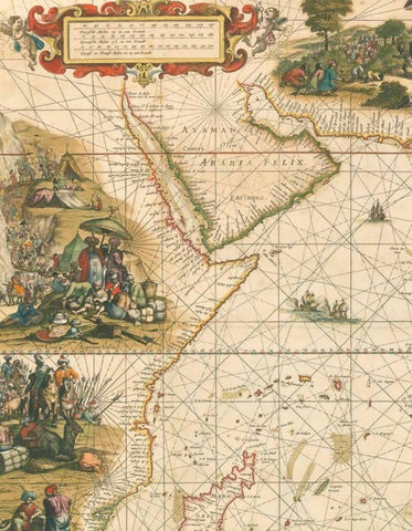
Doncker’s majestic sea chart of the Indian Ocean illuminated by the “Meester Afsetter” Dirk Jansz van Santen
9
DONCKER, Hendrik Pascaerte van Oost Indien… Publication Amsterdam, By Hendrick Doncker Boekverkoper en Graadbooghmaker, Inde Nieuwbrugsteegh, [c1664]. Description Large separately published engraved sea chart, on four sheets joined, fine original hand-colour, heightened in gold. Dimensions 755 by 945mm (29.75 by 37.25 inches).
AED 1,956,000
A splendidly decorated chart with scenic vignettes by Johannes Leupenius (c1646/7-1693), surveyor, draughtsman and printmaker, who may have studied with Rembrandt. The full title of the chart reads: ‘Pascaerte van Oost Indien, met de Omgelegen Eylanden; als Madagascar, Ceylon, Sumatra, Iava, Borneo, Celebes, Molucco en Banda; van C. de Bona Speranca tot Iapan, t’Amsterdam’. Doncker’s ‘Pascaerte van Oost Indien’ is not only extremely decorative, it is also important historically; it is one “of the few charts of the Asian seas printed in seventeenth-century Amsterdam” (Putnam). This is a rare first edition of a chart that was later published by Pieter Goos and Gerard van Keulen. It is also one of the earliest to show the Dutch discoveries on the west coast of Australia. Although there is no date of publication in the cartouche, the chart was cited in an advertisement in Doncker’s 1664 pilot guide of the Mediterranean. In addition to its appearance in Putnam’s book, the Pascaerte van Oost Indien serves as the frontispiece to Suarez’s ‘Early Mapping of Southeast Asia’. Illumination One of the greatest treasures from the Golden Age of Dutch cartography is the 19-volume ‘Atlas van Hadrianus Relandus’ at the MeermannoWestreenianum Museum in The Hague. Not only does it include many legendary maps and sea charts of the seventeenth century, but, according to Herman de la Fontaine Vervey, “the majestic whole has been coloured leaf by leaf by van Santen with the utmost care, using transparent colours, and with even the tiniest details heightened with gold”. He was referring to Dirk Jansz van Santen, the “Meester Afsetter” (master colourist), whose “name was renowned throughout his lifetime and long thereafter, and for whose work there was great demand”. Dirk Jansz. van Santen “illuminated and gilded the most prestigious printed works of his time in an exceptionally painterly and brilliant manner. In so doing, he made the Golden Age, quite literally, golden” (Goedings). His clients were the foremost collectors of his age, who often described his art in similarly eulogistic terms. Rarely do maps coloured in van Santen’s hand come up for sale; rarer still are maps offered that can be ascribed to him with certainty, as he did not sign the works that he illuminated. The present example can confidently be attributed to the master, as the chart is coloured in a manner identical to that used for the same chart in the Hadrianus Relandus atlas. A note in the Relandus atlas reads “artifex eximinus Theodorus van Santen”, and when the atlas came up for sale in 1707, the catalog stated that it was “magnificently coloured by Dirk Jansz van Santen, the equal of Blok”. This comparison to Joanna Blok-Koerten was a strong accolade, as she was the seventeenth century Dutch artist most celebrated for fine colouring. An example from the Relandus atlas, of Doncker’s chart, is illustrated in Robert Putnam’s ‘Early Sea Charts’. Both the present and Relandus
58
DANIEL CROUCH RARE BOOKS
FRIEZE ABU DHABI 2026
examples have pale blue oceans, rich colouring in the decorative vignettes, and the lavish use of gold. Truusje Goedings, author of ‘Dirk Jansz. Van Santen… a Survey’, and acknowledged authority on the works of the master colourist, has examined the present chart and compared them carefully with the map in the Relandus atlas, and has made the following statement: : “I have examined the chart at Daniel Crouch Rare Books, and the equivalent charts in the ‘Atlas van Hadrianus Relandus’ at the Meermanno-Westreenianum Museum in The Hague, and I can confidently conclude that these charts were coloured by the same hand”.
60
DANIEL CROUCH RARE BOOKS
FRIEZE ABU DHABI 2026
The “Blue Map” of the World
10
HUANG, Qianren [Complete Geographical Map of the Everlasting Unified Qing Empire]. Publication [China, 1811]. Description Large woodcut map printed in 16 sections on eight sheets, a few minor repairs. Dimensions 1330 by 2230mm. (52.25 by 87.75 inches). References Richard A. Pegg, Cartographic Traditions in East Asian Maps (Hawai’i: Maclean Collection and University of Hawai’i Press, 2014), 18-27; Yan Ping et al., China in Ancient and Modern Maps, (London: Philip Wilson for Sotheby’s Publications, 1998), 141.
AED 2,201,000
62
DANIEL CROUCH RARE BOOKS
An extraordinarily rare cartographic document that is based on research originally presented to the Qianlong emperor by Huang Qianren (fl. 1760-70) in 1767. The title of the map is as much a political programme of the Qing as it is a geographical record. It shows China at the height of the Qing empire, celebrating the “unified status of all of Chinese borders” (Pegg). “[This] ‘complete’ map minimizes the European notion of a map of the world, its centralized and marginalizing construct confirming the Qing/ Chinese notion of the Central Kingdom” (Pegg). The map was designed to act not only as a grand political statement of the Kingdom’s place in the world, but also as an administrative tool. Its surface is dotted with provincial capitals (sheng), a square with a small rectangle on top; prefectures (fu), a square; independent district magistrates (zhilizhou), a square with a triangle on top; departments (zhou), a vertical rectangle; sub-prefectures (ting), a diamond; districts (xian), a circle; frontier passes (guan), a small building; local headmen or western tribute states (tusi), a triangle; with the name appearing within each pictogram. The borders of each province are denoted by dotted lines. As well as administrative areas, the map depicts topographical and geographical information. Much attention is given to the waterways: the source of the Yellow River is correctly located in the Bayan-har mountain and is accompanied by an expansive explanatory note; the Minjiang River is given as the source of the Yangtze. Mountain ridges and the Great Wall are depicted in elevation, and desert areas are stippled. Several neighbouring countries are marked including Russia, India, Siam, Vietnam, Japan, and, most notably, Korea, who, as the chief vassal state, receives a great deal of commentary.To the upper left of the map are both the Mediterranean or “Small Western Ocean”, and Atlantic or “Great Western Ocean”, with Holland and England depicted as islands in the Atlantic. One of the more striking aspects of the map is that the “intentionally vague geopolitical lines of the [empire’s] frontiers and beyond clearly indicate the Qing’s perception of the world around them ... [when] ... all foreign entities simply inhabited the fringes of the empire” (Pegg). This together with the empire’s size reaffirms the status of the kingdom as the geographical, political, and cultural centre of the world. The map which the present example is based upon was first produced in 1767 for the Qianlong Emperor to celebrate the unification of the Qing empire. No example of the original survives. However, a painted copy of the map was produced in 1800 by Huang Zhengsun, and now resides in the Beijing National Library. The map was then revised and enlarged in around 1811, resulting in the present work. This version was printed in two colours: blue and white, and black and white. There are examples of this version in the Maclean Collection in Chicago, the Library of Congress, and the Beijing National Library.
FRIEZE ABU DHABI 2026
Charting the Unfathomable Sky
11
QIAN Yong, [HUANG Shang 黃裳] Huntian yitong xingxiang quantu 渾天壹統星象全圖 [Complete Celestial Chart]. Publication [China], April 1826. Description Large woodblock-printed celestial map printed on eight sheets. Dimensions 1230 by 2160mm. (48.5 by 85 inches). References Chen Kaige 陳凱歌. “Suzhou Daoguang muke Tianwen tu – Huntian yitong xingxiang quantu de yanjiu yu fuyuan” 苏州 道光木刻天文图——《浑天壹统星象全图》 的研究与复原. In Zhongguo tianwenxue huixueshu nianhui wenji 中国天文学会学术 年会文集, 2013. Dai Yushan 戴玉山. “Shishu wu jizai de Huntian yitong xingxiang quantu”史书无记 载的《浑天一统星象全图》. Zhongguo keji shike, no. 1, 2003. Elman, Benjamin A. From Philosophy to Philology: Intellectual and Social Aspects of Change in Late Imperial China. Los Angeles: UCLA Asian Pacific Monograph Series, 2001 (Second Revised Edition). Erwin Panofsky. Studies in Iconology: Humanistic Themes in the Art of the Renaissance. New York: Oxford University Press, 1939. Kazuhiko, Miyajima 宮島一彥 et al. “Huntian yitong xingxiang quantu” 渾天壱統星象全図. Daban shili kexueguan yanjiu baogao 26, pp. 75–84, 2016. Needham, Joseph et al. “Astronomy in Ancient and Medieval China.” Philosophical Transactions of the Royal Society of London. Series A, Mathematical and Physical Sciences, Volume 276, Issue 1257, 1974. Pankenier, David W. Astrology and Cosmology in Early China: Conforming Earth to Heaven. Cambridge: Cambridge University Press, 2013. Ridpath, Ian. Charting the Chinese Sky. [http://www.ianridpath.com/startales/ chinese3.htm Accessed on 01/05/2019] Rufus, W. Carl and Hsing-Chih Tien. The Soochow Astronomical Chart. Ann Arbor: University of Michigan Press, 1945. Zhang Jiafeng 張嘉鳳. Zhongguo gudai de tianwen yu lifa gaishuo 中国古代的天文與历 法概说. Taiwan: Guojia tushuguan, 2009.
AED 2,201,000
68
DANIEL CROUCH RARE BOOKS
A monumental Chinese celestial chart Huntian yitong xingxiang quantu, one of the largest planispheres published during the Qing dynasty (1636-1912). The work combines both Chinese and Western astronomy, highlights the fundamental role that knowledge of the heavens played in Chinese politics, and illustrates the Qing dynasty’s endeavours to seek authentic truth in ancient texts. Historical context Chinese scholarship in the late Qing dynasty was dominated by ‘Kaozheng’ or ‘evidence based’ scholarship, which was a response to, and reaction from, the Neo-Confucianism that had held sway during the Song (960-1279) and Ming (1368-1636) dynasties. ‘Kaozheng’ sought to strip away the layers of Taoist and Buddhist interpretations of Confucian teaching that had accrued during the Song and Ming dynasties, and which they saw as obscuring its true meaning and nature. In doing so the Qing scholars hoped to not only shed new light on the ancient texts but that the texts might be better guides for contemporary policy and politics. ‘Kaozheng’ with its emphasis on critical thinking, and search for authentic texts, was not only confined to the realm of Confucian scholarship but also bled though into all aspects of Chinese intellectual enquiry, such as science and in the present case astronomy. The Celestial Chart The present chart is based on the oldest recorded celestial planisphere, the Tianwen tu 天文圖 produced, during the Southern Song dynasty (1127-1279), by Huang Shang 黃裳 (1146-1194) tutor to Emperor Guangzong’s son. The work was engraved on stone by Wang Zhiyuan 王致远 (1193-1257) in 1247, and set up in the Confucian Temple in Suzhou, where it still stands. As well as depicting the heavens, and providing an introduction to the birth of the cosmos, the planisphere bore an overt political message: that the tian 天 (Sky or Heaven), would bestow tianming 天命 (“The Will of the Sky,” or “The Mandate of Heaven”) on just rulers of China – named Tianzi 天子 (Son of Heaven), similar to the divine right of kings prevalent in Europe. The chart thus reassures the Song Emperor that, despite recently losing the north of China to the Jurchen, he still had the ‘Mandate of Heaven’ and was still China’s rightful ruler. A message that would not have been lost on the Qing scholars, whose own times were beset by internal rebellion and encroachment from belligerent Western powers. The present chart is no mere copy of Huang Shang’s work, and shows significant revision and updating to include new constellations and western geographical information. One of the most intriguing differences can be seen to the title, which contains the characters Huntian 渾天, and illustrates the Qing scholars continuing interest in the Later Han 後漢
FRIEZE ABU DHABI 2026
dynasty (25-220) (especially Confucian) philosophy and philology. The term refers to Huntian shuo 渾天說 (Spherical-Heaven Theory) which was formulated during the Later Han, and argued that a spherical earth was suspended within a celestial sphere. It displaced an ancient celestial theory, Gaitian shuo 蓋天說 (Canopy-Heaven Theory), which stated that the earth was a square and covered umbrella-like by a celestial hemisphere. The present chart can be seen as an embodiment of the Qing ‘Kaozheng’ scholars’ principles: the study of ancient, primary sources, in this case the Tianwen tu celestial planisphere, in order to better understand the past, so that it might be a truer and more accurate guide to the present. Content The content of the chart can be divided into four sections: the title to the far right, the text surrounding the chart, the celestial chart itself, and the colophon to the far left. Colophon Author: QIAN YONG. Date: April 1826. “道光六年歲在丙戌孟夏之月” (The sixth year of the Daoguang reign period (1826) April in the lunar calendar), “金匱梅溪錢泳書” (Written by Mei Xi (Pseudonym) Qian Yong (Author) from Jingui (A town in Jiangsu Province)). Title The title: Huntian yitong xingxiang quantu contains more information than the Song chart. The first two characters, Huntian 渾天, refer to Huntian shuo, the second of the three main celestial theories in ancient Chinese astronomy. It was proposed by the Later Han scholar Zhang Heng 張衡 (78-139) who compared the earth and the celestial sphere with the structure of an egg, with earth being the egg yolk and the celestial sphere being the shell. This theory is stated at the beginning of the paragraph entitled Tiandi xing 天地形 (The Shape of Heaven and Earth) printed on the fifth panel from the right below the chart. Text The text is a revised version based on the Song chart, with additional celestial and geographical information; most notably information drawn from European Jesuit sources such as Matteo Ricci’s Kunyu wanguo quantu 坤輿萬國全圖 (Complete Map of the World). Layout and Content The text on the present chart runs from right to left and is divided into sixteen sections with titles positively printed in blue on white; eleven in the upper half of the work and five in the lower. 72
DANIEL CROUCH RARE BOOKS
FRIEZE ABU DHABI 2026
The introduction reads: 太極未判,天地人三才函於其中,謂之混沌,言天地人渾然 而未分也。太極既判,輕清者為天,重濁者為地,兼清帶濁者為 人。 輕清者氣也,重濁者形也,形氣合者人也。故凡氣之發見於 天者,皆太極中自然之理。運而為日月,分而為五星,列而為二十 八舎,會而為斗極,莫不皆有常理,與人道相應,可以理而知也。 今畧舉其梗概,列之於下。 Before the Great Absolute had unfolded itself the three primal essences, Heaven, Earth, and Man, were involved within it. This was termed original chaos because the intermingled essences had not yet separated. When the Great Absolute unfolded, the light and pure formed Heaven, the heavy and impure formed Earth, and the mingled pure and impure formed Man. The light and pure constitute spirit, the heavy and impure constitute body, and the union of spirit and body constitutes man. Hence all manifestations of spirit emanate from Heaven, for a natural reason, as they are inherent in the Great Absolute. This evolves into the sun and the moon, divides into the five planets, arranges in order as the twenty-eight mansions, and meets to form the directors and the circumpolar stars. All of these, being involved in the immutable reason, are also in harmony with the rational principle in Man, hence they may be interpreted by reason. Now let us consider and expound the general essentials of the subject as follows. This introduction explains the celestial system as perceived in China using sixteen astronomical entities, which are given printed in blue text in white boxes: Tianti 天體 (The Celestial Body), Diti 地體 (The Terrestrial Body), Liang ji 兩極 (The Two Poles), Riti 日體 (The Sun), Yueti 月體 (The Moon), Jingxing 經星 (The Fixed Stars), Weixing 緯星 (The Planets), Tianhan 天漢 (The Milky Way), Shi’er chen 十二辰 (The Twelve Branches), Shi’er ci 十二次 (The Twelve Positions), Shi’er fen ye 十二分野 (The Twelve Kingdoms), Jiu tian 九天 (The Nine Skies), San ji 三際 (The Three borders), Xingbian 星變 (Star Transformations), Kexing 客星 (The New Star), and Tiandi xing 天地形 (The Shape of the Heaven and Earth). When compared with the Song chart, the most notable change is the addition of the last five sections, i.e. the Nine Skies, Three Borders, Star Transformations, New Star, and the Shape of Heaven and Earth. The text goes on to deal with geographical matters: much of the ‘new’ geographical information added is drawn from knowledge brought into China by the Jesuits during the sixteenth century. One of the most notable examples is contained in the last paragraph which references Tiandi xing, “地名墨瓦蠟泥加洲…” (The continent called Magallanes…). The “Magallanes” (now Australia) “墨瓦蠟泥加洲” was first introduced to China by Matteo Ricci 利瑪竇 (1552-1610) and was included on his Kunyu Wanguo Quantu 坤輿萬國全圖 (Complete Map of the World).
The Planisphere The work preserves the key features of the Song chart, i.e. centred on the North Pole, giving the outline of the Milky Way, providing the circle of constant visibility (the smallest circle) and the equator (the third concentric circle from the center), and depicting all the constellations, and the diameters of the chart and the equator are the same. However, the Qing chart not only adds new constellations but is also rotates the chart by 180 degrees and omits the ecliptic. Furthermore, it adds two further concentric circles: the Tropic of Cancer (inside the equator, the second from the centre) and the Tropic of Capricorn (outside the equator, the fourth from the centre). Unlike the twelve houses of the zodiac devised by Western astronomy, Chinese astronomers identified 28 divisions in the sky known collectively as the Ershi ba xingxiu 二十八星宿 (28 Lunar Lodgings). These divisions are termed xiu 宿 (Mansions or Lunar Lodges), and were used to measure the coordinates of celestial bodies and constellations along the equator. The Song chart only shows the divisions in the outermost ring, where the Qing depicts divisions throughout the chart stemming from the innermost circle. We have been able to identify three states of the chart: 1. Author: YUNYOU SANREN. Date: March 25th 1822. 2. Author: SONG TAO. Date: March, 1826. 3. Author: QIAN YONG. Date: April 1826. There are slight differences between the 1822 and 1826 editions in terms of the textual content and layout. Curiously, the later 1826 editions are more faithful to the earlier Song chart, as the text is almost identical with only minor variations of the characters. Rarity We have been able to trace five extant examples of the 1822 edition: a) Konko Library, Japan. b) Collection of Prof. Miyajima Kazuhiko 宮島一彥, Japan. c) Collection of Tsujiyoshi family, Japan. d) Two in private collections, China. Two copies with the same colophon as the 1822 edition can also be found in the Omura City Archives and Matura Historical Museum in Japan, but with shorter text and two fewer panels than the present example. We are only able to trace one institutional example of the March 1826 edition: a) Tsuyama City Museum, Japan. We are only able to trace two institutional examples of the April 1826 edition: a) Jissoin Temple in Japan. b) Adler Planetarium in the USA. 74
DANIEL CROUCH RARE BOOKS
FRIEZE ABU DHABI 2026
First map to name Abu Dhabi
12
BERGHAUS, Heinrich Karl Wilhelm [Persian Gulf, 1832] ReduzirteKarte vom Persischen Golf. Publication [Berghaus, 1832]. Description Hand-coloured engraved map, dissected and mounted on linen. Dimensions 432 by 610mm (17 by 24 inches). References Alai, C., Special Maps of Persia 1477–1925, E. 292, Pl. 167. Yale University, Beinecke Rare Book and Manuscript Library, #534cea 1832. OCLC 248589175.
AED 245,000
76
DANIEL CROUCH RARE BOOKS
The earliest printed map to name Abu Dhabi (Abuthubbi / Bûthabîn / )أبوظبي. The map was created for Berghaus’s seminal Atlas von Asia, a loose-leaf collection of regional maps of Asia, identified by historian Cyrus Alai as “the most detailed” of the Gulf region. The map extends, north to south from Basra (Bashra; )ٱ ْْلَبَْصْ َرَ ةto Muscat (Maskat, Oman; ْسَقَط ْ ) ََم, and features six maps, including Manama ْ ()اْل ََمَنَاَمَة, then, as now, the capital of Bahrain (Bahrein, )جزيرة البحرين. On the Qatar peninsula, it names the now ruined city of Zubarah ()الزبارة and Al Bidda (Doha; )البدع. In the modern-day United Arab Emirates, it names Abu Dhabi (Abuthubbi, Bûthabîn; )أبوظبي, Dubai (Debai; )دبي, Sharjah (Scharga, ّاِر ََقة ِ )ِإَمَاَرَ ة ٱلَّش, ِ Amelgawein (Umm Al Quwain, )أم القيوين, Al Jazeera al Hamra (Djesirat el Amrah; )الجزيرة الحمراء, and Ras Al-Khaimah (Ras el Khyma; )َرَ ْْأس ٱ ْْلَخَ ْيَْمَة- marking it as one of the first, if not the first, to detail these coasts. Further north, near the Tigres and Euphrates Delta, Kuwait (El Koueit Grän; )َدَْوْ ََل ُُة الكويتis visible. From Bushehr (Buschir, Iran; )بوشهر, inland caravan routes are illustrated stretching east through “Farsistan” and beyond. Berghaus acknowledges the “Officers of the Bombay Marine” for the work and maintained an active correspondence with the British hydrographer James Horsburgh, of which he wrote: “I stated that the depiction of the Persian Gulf was a reduced copy of my reduced chart of that Gulf (No. 12 of the Atlas). The attentive reader will also recall from the memoir accompanying that chart that its construction was based upon the investigations of the Bombay Marine, insofar as they had been made known by Horsburgh in his classic work. However, I had not seen the survey sheets themselves, which were not completed until the course of 1832, that is, a year after I had drafted my map. Captain James Horsburgh was kind enough to send me, in the spring of 1833, the general chart of the Persian Gulf, compiled from the detailed survey sheets of the officers of the Bombay Marine. It is this general chart that served as the basis for the improved representation of the gulf on the Map of Arabia. A comparison with the reduced chart of the Persian Gulf will show that, although the overall configuration and the geographical positions of the principal points are the same on both maps, a greater degree of precision could be achieved in the details. Furthermore, the gap in our knowledge of the Arabian coast between El-Katif (al-Qatif ) and El-Koueit (Kuwait) has now been filled.” (Berghaus, H., Geographisches memoir zur erklärung und erlaüterung der Karte von Syrien, (no. 5. Atlas von Asia), page 16.)
FRIEZE ABU DHABI 2026
This map thus relies on the Bombay Marine surveys of George Barnes Brucks, G. M. Guy, Robert Cogan, S. B. Haines, and W. E. Rogers. This work, at the time, existed only in manuscript, a copy of which was apparently supplied, in part or full, to Berghaus by Horsburgh, as the British chart itself (Alai, C., Special Map of Persia, #E291) was not printed until 1832, shortly after this Berghaus map was issued. First Map to Name Abu Dhabi This is almost certainly the earliest printed map to name Abu Dhabi. There are only two other contenders for this title, neither of which is earlier. The first is the Persian Gulf map issued by the Admiralty Hydrographic Office in 1832 (the same year this map was issued, but, as above, later). The second is the Ehrenberg / Rüppell map of Arabia, Arabia und das Nil-Land, also part of Berghaus’s Atlas von Asia, but issued in 1835, so 3 years later. The comparatively late appearance of Abu Dhabi on maps is not surprising. Unlike neighboring Dubai, recorded in print as early as 1590, Abu Dhabi was not settled until 1793, when the Bani Yas Bedouin moved to the island in search of fresh water. The first major surveys to follow were completed by the Bombay Marine in 1830; no other earlier cartography would have had new information about this coast. Consequently, this is one of the earliest printed maps to name Abu Dhabi. The significance of the present map to Abu Dhabi has likely gone unnoticed due to its exceptional rarity and lack of digitized examples. Publication History and Census This map was drafted by Heinrich Berghaus in 1831 and engraved by C. H. Herterich for publication in 1832. Today it is very rare. Cartographers Heinrich Karl Wilhelm Berghaus (1797-1884) was a German (Prussian) geographer, linguist, and ethnologist who founded the Potsdam Geographische Kunstschule. He was born in Kleve, Germany, and, as a young man, trained as a surveyor. He put his training to work in 1811, working in the French Department of Lippe as a bridge and road engineer. When the Kingdom of Westphalia dissolved in 1813, he volunteered for the Prussian army administration, traveling with General Bogislav Friedrich Emanuel von Tauentzien (1760 – 1824) as far as Brittany. In 1816, he joined the staff of the Prussian trigonometrical survey, conducting surveys throughout the nation. Among his many accomplishments, Berghaus is credited with inventing the “thematic atlas” in 1845.
80
DANIEL CROUCH RARE BOOKS
FRIEZE ABU DHABI 2026
In addition to his own work, he trained some of the most important German geographers and cartographers of the late 19th century, including August Heinrich Petermann (1822-1878) and his nephew Hermann Berghaus (1828-1890). The elder Berghaus also was a friend and associate of the naturalist Alexander von Humboldt (1769-1859), producing some of the maps in his publications. Berghaus is best known for his own influential and wide-ranging atlases, namely Atlas von Asien, published between 1833 and 1837, and Berghaus’ Physikalischer Atlas, published in multiple editions in the 1830s-1840s. Although Atlas von Asien was a commercial failure, it was regarded as a work of supreme quality, boosting the reputation of the publisher Justus Perthes and setting up their next collaboration, Berghaus’ Physikalischer Atlas, for success. C. H. Herterick (fl. c. 1825–1840) was a German engraver active in the first half of the 19th century. Herterick is mostly associated with the output of the Gotha-based Justus Perthes firm, including the works of Heinrich Berghaus (1797–1884), Carl Ritter (1779–1859), and Heinrich Kiepert (1818–1899). Heinrich Berghaus’s Atlas von Asien was an 18-map loose-leaf atlas issued by Justus Perthes between 1832 and 1858. Of the 18 proposed maps, only 15 were published. Individual maps were large with unprecedented detail. These include 10 land maps and 7 nautical charts derived from British, Dutch, and Portuguese colonial, scientific, and diplomatic missions. Despite this, the project was a financial failure due to the high cost of engraving such large and intricate maps. It took more than 25 years for the maps to be fully published and, according to the Perthes archive, only 20 sets were ultimately bound and sold. The publication run per map ran between 200 to 550 maps, most of which were offered separately. The breadth, detail, and comprehensiveness of the work surpassed any previous mapping of the respective subjects. Although not a direct financial success, the Atlas von Asien was a monumental cartographic accomplishment that put the Perthes firm on par with the great cartographic firms of England and France.
FRIEZE ABU DHABI 2026
DANIEL CROUCH RARE BOOKS
81
The earliest obtainable atlas printed in Arabic
13
[CHURCH MISSIONARY SOCIETY] Atlas, ay majmu’ kharitat rasm al-ard... [Atlas or a collection of maps, drawings of the earth comprising: first Eastern half of the globe, second Western half of the globe, third Europe, fourth Asia and Australia, fifth Africa, sixth America, seventh The Land of Egypt, eight The Land of Sham and offers it in a valued printing for the benefit of schools]. Publication [Malta, 1835]. Description Oblong 4to (310 by 455mm), 11 lithograph maps, original hand-colour in outline, bound in plano, original wrappers with title. References Ganado, A., Schiro, J. and Attard, C.M., ‘The Brocktorff Mapmakers’, BDL, 2012.
AED 293,500
82
DANIEL CROUCH RARE BOOKS
The earliest obtainable atlas printed in Arabic. Cartographic publishing in the Muslim world was largely stifled until the nineteenth century by Ottoman proscriptions on printing. Although several atlases, such as the Celebi and Cedid atlases, and maps, the Hajji Anmed Mappamundi for example, were published in Venice with the intent of exportation to the Ottoman Empire, these attempts were unsuccessful. Furthermore, they were all printed in Ottoman Turkish, not Arabic. Malta, with its proximity to the Arab world and Ottoman Empire, but its status as a British Crown Colony, was a natural place for the first Arabic atlas to be published. ”When the Anglican Church Missionary Society decided to establish a Mediterranean Mission in 1815 to evangelize the peoples of Southern Europe, North Africa and the Middle East, they directed their attention to Malta which occupied a central position in the Mediterranean and so geographically lay on the main communication and trading routes between east and west and north and south. The C.M.S. immediately appointed Dr Cleardo Naudi, a Maltese Professor of Chemistry, at the University of Malta, as their correspondent in Malta and sent William Jowett in 1815 to go to the Mediterranean and the Middle East to study the different religious communities and to formulate plans for ‘propagating Christian knowledge’ among them. After nine years sojourning and travelling in the Eastern Mediterranean, Jowett concluded by emphasizing the importance of education first, before trying to spread the evangelical message, and he felt it very important that the C.M.S. should provide a range of educational books by creating a printing establishment. Malta offered the best advantages for such an undertaking. The Committee of the C.M.S. were impressed with Jowett’s reports and pledged their support but after many delays in the procurement of Arabic and Greek founts [sic?] and other equipment, the first Arabic books came out only in 1827. However the C.M.S. Press initially faced many problems with their setters and printers as they had no knowledge of Arabic. This changed when Christoph Friedrich Schlienz (1803-68) who was born in Kirchheim in Wurttemberg joined the C.M.S. Press in Malta and eventually became its Superintendent. With the aid of Matthdus Weiss, the C.M.S. printer in Malta, and George Percy Badger and Faris al-Shidyaq acting as translators into Arabic and editors of the Arabic script, the C.M.S. published most of the Arabic books in Malta between 1827 and 1840. Besides, it results from the Malta Government Accounts for 1831 that an allowance of £30 was being paid to a student in Asia Minor to study Arabic, and in 1832 an allowance of £70 was paid to a gentleman abroad to perfect himself in the Arabic language.
FRIEZE ABU DHABI 2026
When in 1832 Schlienz discovered that a German lithographer was living in Malta, he immediately contracted two of his sons, Frederico and Luigi [Brocktorff ] as lithographers, and Francesco, another son, as a binder. The C.M.S. took a pioneering role in the introduction of printing in the Arab world... However although the output of printed works was impressive, the distribution of books was weak and with mounting debts the C.M.S. printing press had to close down in 1842 and was eventually bought by Matthaus Weiss”. Although it was not printed in large numbers, the atlas had a significant impact in the Arab world. It was quickly reproduced in Cairo, from where Lord Lindsay wrote in December 1836: “perhaps the most useful work the Pasha has published is an Atlas in Arabic. Copied from one the missionaries have executed at Malta” (Ganado, Shiro and Attard). The 1833 Malta atlas, the very first example of this kind, is unobtainable today, with the only known copies held in the Albert Ganado Melitensia Collection, and by the British Museum. The present example, published two years later at Malta, is also exceptionally rare. Complement of Maps 1. [Map of the World, Western Hemisphere] 2. [Map of the World, Eastern Hemisphere] 3. [Map of Europe] 4. [Map of Russia] 5. [Map of Africa] 6. [Map of North and South America] 7. [Map of Australia] 8. [Map of North Africa] 9. [Map of Asia] 10. [Map of Asia] 11. [Map of Eastern Mediterranean].
84
DANIEL CROUCH RARE BOOKS
FRIEZE ABU DHABI 2026
Chesney’s and Plate’s map of Arabia and Syria
14
CHESNEY, [Francis Rawdon] and W[illiam] H[enry] PLATE A Map of Arabia & Syria. Laid down chiefly from Original Surveys Under the Superintendence of Lieut. Colonel Chesney, R.A. F.R.S. And drawn by W.H. Plate, L.L.D. Hon. Forn. Secretary of the Syro-Egyptian Society of London, M. Geograph. Soc. of Paris, Corresponding Member of the Oriental Society of Germany &c. Publication London, Published by Longman, Brown & Co. Paternoster Row, 1849. Description Engraved map, with hand-colour in part, left and right margin trimmed to neatline, fold-out section on right edge showing Ras al Hadd. Dimensions 700 by 650mm (27.5 by 25.5 inches).
AED 196,000
Beautifully engraved map of Arabia and Syria. The present map was published in 1849, a revised edition of a map first published in 1847, under the title “Arabia”, of which only one institutional example is known, held at the British Library. Cartographically, it is a compilation of various sources. As the note underneath the title explains: “Mesopotamia and its rivers are laid down from Surveys made during the Euphrates Expedition. The Red Sea, the Persian Gulf and the Southern Coast of Arabia, are from those made by the Officers of the Indian Navy. The interior of the peninsula is from various sources, particularly Materials furnished for the accompanying work by Aloys Sprenger M.D. and from documents obtained by Dr Plate”. General Francis Rawdon Chesney (1789-1872) was a British soldier and explorer. Known for his proposal to build the Suez Canal, a proposal which would form the basis of Ferdinand de Lesseps’s undertaking, he also oversaw an 1836 survey of the River Euphrates (likely the “Euphrates Expedition” mentioned in the note on the present map), in an attempt to open a faster route between England and India for the East India Company. The Indian Navy was the naval arm of the English East India Company, which systematically charted the Arabian Coast between 1820 and 1839. In 1820, Captain George Barnes Brucks began to chart the Arabian Gulf; in 1829, Captains Elwon, Moresby, and Careless began to chart the Red Sea; and in 1837, Captain Haines would begin to chart Aden and the southern Arabian coast. So accurate were these surveys, designed to aid shipping, encourage trade, and suppress piracy, that they would become the standard works for much of the coast until well into the twentieth century, as the present map attests. We have been unable to trace much information about William Henry Plate. He is named as the author of the 1847 “Arabia” map, also a collaboration with Chesney, and of a map of Asia Minor, published by Edward Stanford in around 1849. Rarity We have located only five institutional examples of this map: the National Library of Scotland, the University of Glasgow, Harvard University, the British Library, and Qatar National Library.
86
DANIEL CROUCH RARE BOOKS
FRIEZE ABU DHABI 2026
Black Gold
15
US GEOLOGICAL SURVEY, ARABIAN AMERICAN OIL COMPANY Geologic Map of the Arabian Peninsula. Compiled by the U.S. Geological Survey and the Arabian American Oil Company under the joint sponsorship of the Kingdom of Saudi Arabia, Ministry of Petroleum and Mineral Resources, and the U.S. Department of State. Publication Washington, D.C., The US Geological Survey, 1963. Description Chromolithograph map. Dimensions 1290 by 1850mm (50.75 by 72.75 inches). References Powers, Ramirez, Redmond, Elberg, Geology of the Arabian Peninsula, Sedimentary Geology of Saudi Arabia, U.S. Geological Survey Professional Paper, 1966.
AED 73,500
88
DANIEL CROUCH RARE BOOKS
Large and detailed map depicting the geology of the Saudi Arabian Peninsula. The search for oil on the Peninsula started in 1933, when the Saudi Arabian government granted an oil concession to Standard Oil Co. of California (which was later joined by Texaco buying a 50% stake in the concession). Geologists soon followed to start the surface mapping of the area and beyond, achieving by 1937 a broad understanding of the region’s geological strata. The first test to yield oil was in Dhahran on 4 March 1938. After a hiatus during WWII, the activity of surveying and test-drilling resumed with reinvigorated effort. Aerial photography was introduced in 1949 and proved an invaluable tool for the surveying. In 1954 the US Geological Survey and Aramco, the Arabian American Oil Company, began work on a series of geological and geographic maps which would incorporate the data collected over the years. The project was sponsored by the US Department of State and the Kingdom of Saudi Arabia. The effort resulted in 1:500,000-scale geologic sheets and a 1:200,000-scale geological map of the Arabian Peninsula, and the base topographical map - the present maps. The geological map delineates the strata of the peninsula, with colour codes in two tables on either sides, and text within the blank regions of Eastern Africa and Iran. A paper to accompany the map and further explain the geology was published in 1966 by the US Geological Survey.
FRIEZE ABU DHABI 2026
Arabic edition of a landmark in the cartography of the UAE
16
MUSTAFA, Ezzedin Ibrahim; and Muhammad Morsi ABDULLAH [United Arab Emirates]. Publication London & Abu Dhabi, George Philip & Son & Centre for Documentation and Research, Ministry of Cabinet Affairs, 1974. Description Chromolithograph map, folding into publisher’s blue paper covers. Dimensions 587 by 735mm (23 by 29 inches).
AED 37,000
90
DANIEL CROUCH RARE BOOKS
Arabic and smaller-format edition of a landmark in the cartography of the UAE, the most detailed map of the region, first published in 1973, just two years after the formal establishment of the UAE, on December 2, 1971. The map illustrates, in the year before the Treaty of Jeddah (1974), the undefined borders between the UAE and Qatar, the UAE and Saudi Arabia and the UAE and Oman, all of which would go on to be contested. In the Gulf, pearl fisheries are denoted in pink, while infrastructure including oil fields, airports, and water pipelines are also depicted. Abu Dhabi, Dubai, and Sharjah are all marked, as are the villages around the Liwa Oasis. Below the map is an inset showing the UAE in its broader regional context, an inset showing the areas populated by different oil companies (including Abu Dhabi Oil Company, Pan Ocean Oil Company, and Dubai Petroleum Company), along with a table of oil production, between 1968 and 1972, and some explanatory text about the United Arab Emirates. This Arabic edition would be issued simultaneously with an edition in English. The map was produced by Muhammad Morsi Abdullah (1929-2005), historian, cartographer, and social scientist, who would serve as the director for the Centre for Documentation and Research (precursor to the UAE National Archives). He was responsible for the first official maps both of Abu Dhabi and of the UAE and would write ‘The United Arab Emirates: A Modern History’, in 1978. Ezzedin Ibrahim Mustafah (1928-2010) was an Egyptian-born scholar, who would serve as cultural adviser to Sheikh Zayed, playing a fundamental role in the establishment of the Cultural Foundation in Abu Dhabi, comprising: the National Archives, National Library, and Institute of Culture and Art. In recognition of his work, he would be granted citizenship of the UAE.
FRIEZE ABU DHABI 2026
Abu Dhabi from above
17
LANDSAT [Group of four aerial photographs of Abu Dhabi]. Publication 1984-1985. Description Four mammoth c-type photographs, on Kodak paper. Dimensions 855 by 805mm (33.75 by 31.75 inches).
AED 391,000
A group of four mammoth aerial photographs of Abu Dhabi, most likely commissioned for a construction firm, taken at a point when the city was in the midst of rapid development. Aerial photography and cartography share a deep artistic and scientific relationship rooted in the ways both practices translate the earth’s surface into visual form. While cartography traditionally relies on symbolic representation and abstraction, aerial photography offers a direct visual record of landscapes. Together, they create a dialogue between realism and interpretation, between the literal and the symbolic, and between the observable world and human patterns of meaning. Shared Visual Languages Both aerial photography and cartography engage with scale, perspective, and spatial accuracy. An aerial photograph, taken from above, flattens the landscape into a plane, much like a map. This bird’s-eye view eliminates the immediacy of ground-level perception, replacing it with a detached, omniscient perspective that emphasizes form, pattern, and relation. Cartographers have historically used this vertical perspective as the foundation of map-making, abstracting geographic features from either direct observation, surveys, or - later - the photographic record. This shared viewpoint has artistic implications. Seen from above, landscapes organize themselves into patterns of symmetry, rhythm, and contrast. Agricultural fields resemble geometric mosaics; rivers carve graphic lines; and cities display intricate grids or organic webs. Both cartographic drawings and aerial photographs highlight this aesthetic of order and abstraction, often blurring the boundary between functional technique and visual art. From Documentation to Interpretation A twentieth-century shift brought aerial photography into the realm of cartographic practice as tools like photogrammetry were developed. Photographs became raw data for map-making, yet artists also recognized their visual power as independent works, not merely technical resources. Similarly, maps have always walked a line between utility and artistry. Medieval maps, with their elaborate illustrations, and modern artistic maps that emphasize concept over accuracy, demonstrate how mapping is as much an act of storytelling as it is one of measurement. Aerial photographs extend this tradition, creating images that are truthful records yet still demand interpretation, inviting viewers to consider the aesthetic and symbolic qualities of land. Both practices involve choices of framing, emphasis, and omission. A cartographer simplifies a world full of infinite data into a legible system of symbols, colours, and boundaries. An aerial photographer
92
DANIEL CROUCH RARE BOOKS
FRIEZE ABU DHABI 2026
frames particular regions, angles, and moments that highlight shapes invisible from the ground. In this way, both acts turn complex realities into constructed narratives. Artistically, this creates parallels with painting: just as a painter emphasizes certain features to reveal essence or mood, both cartographer and aerial photographer reveal the hidden structures of place. Landsat Landsat is the world’s longest-running land-observing satellite program, launched in 1972 and jointly managed by NASA and the US Geological Survey[astronomy +1]. Its satellites capture multispectral images every 16 days, enabling monitoring of agriculture, climate change, and disasters, with all resulting data available to the public for free. Original Landsat colour prints from the early years of the program (1970s–1980s) are quite rare, especially as stand-alone colour photographic prints and mosaics, because they were produced in limited quantities for government, scientific, and select public uses, rather than commercial distribution or mass retail sales. Individual Landsat colour prints—especially large-format mosaics or photoprints from the 1970s and early 1980s—were expensive to produce and priced accordingly (large colour prints could cost hundreds to over a thousand dollars, even in the 1980s), restricting their circulation.
94
DANIEL CROUCH RARE BOOKS
FRIEZE ABU DHABI 2026
Dubai from the sky
18
[LANDSAT, attributed to] [Aerial photograph of Dubai]. Publication [c1984-1985]. Description Mammoth c-type photograph, on Kodak safety paper, pinhole marks to corners, small tear to right margin. Together with Gabriel, ‘The Dubai Handbook’ (1987). Dimensions 1267 by 1254mm. (50 by 49.25 inches).
AED 147,000
Mammoth aerial photograph of Dubai, taken at a vital point in its development. The image would almost certainly have been commissioned for a construction firm, the pinholes in the corners of the photograph suggesting that, at one stage, it would have been pinned up on an office wall. Visible in the photograph are the Dubai Creek, flowing into Port Rashid, Dubai International Airport, with two aeroplanes, and the World Trade Centre, construction of which had been completed in 1979. Aerial photography and cartography share a deep artistic and scientific relationship rooted in the ways both practices translate the earth’s surface into visual form. While cartography traditionally relies on symbolic representation and abstraction, aerial photography offers a direct visual record of landscapes. Together, they create a dialogue between realism and interpretation, between the literal and the symbolic, and between the observable world and human patterns of meaning. Shared Visual Languages Both aerial photography and cartography engage with scale, perspective, and spatial accuracy. An aerial photograph, taken from above, flattens the landscape into a plane, much like a map. This bird’s-eye view eliminates the immediacy of ground-level perception, replacing it with a detached, omniscient perspective that emphasizes form, pattern, and relation. Cartographers have historically used this vertical perspective as the foundation of map-making, abstracting geographic features from either direct observation, surveys, or - later - the photographic record. This shared viewpoint has artistic implications. Seen from above, landscapes organize themselves into patterns of symmetry, rhythm, and contrast. Agricultural fields resemble geometric mosaics; rivers carve graphic lines; and cities display intricate grids or organic webs. Both cartographic drawings and aerial photographs highlight this aesthetic of order and abstraction, often blurring the boundary between functional technique and visual art. From Documentation to Interpretation A twentieth-century shift brought aerial photography into the realm of cartographic practice as tools like photogrammetry were developed. Photographs became raw data for map-making, yet artists also recognized their visual power as independent works, not merely technical resources. Similarly, maps have always walked a line between utility and artistry. Medieval maps, with their elaborate illustrations, and modern artistic maps that emphasize concept over accuracy, demonstrate how mapping is as much an act of storytelling as it is one of measurement. Aerial
96
DANIEL CROUCH RARE BOOKS
FRIEZE ABU DHABI 2026
photographs extend this tradition, creating images that are truthful records yet still demand interpretation, inviting viewers to consider the aesthetic and symbolic qualities of land. Both practices involve choices of framing, emphasis, and omission. A cartographer simplifies a world full of infinite data into a legible system of symbols, colours, and boundaries. An aerial photographer frames particular regions, angles, and moments that highlight shapes invisible from the ground. In this way, both acts turn complex realities into constructed narratives. Artistically, this creates parallels with painting: just as a painter emphasizes certain features to reveal essence or mood, both cartographer and aerial photographer reveal the hidden structures of place. Landsat The photograph is attributed to Landsat, the world’s longest-running land-observing satellite program, launched in 1972 and jointly managed by NASA and the US Geological Survey[astronomy +1]. Its satellites capture multispectral images every 16 days, enabling monitoring of agriculture, climate change, and disasters, with all resulting data available to the public for free. Original Landsat colour prints from the early years of the program (1970s–1980s) are quite rare, especially as stand-alone colour photographic prints and mosaics, because they were produced in limited quantities for government, scientific, and select public uses, rather than commercial distribution or mass retail sales. Individual Landsat colour prints—especially large-format mosaics or photoprints from the 1970s and early 1980s—were expensive to produce and priced accordingly (large colour prints could cost hundreds to over a thousand dollars, even in the 1980s), restricting their circulation.
98
DANIEL CROUCH RARE BOOKS
FRIEZE ABU DHABI 2026
100
DANIEL CROUCH RARE BOOKS
FRIEZE ABU DHABI 2026