33 minute read
The universal planisphere

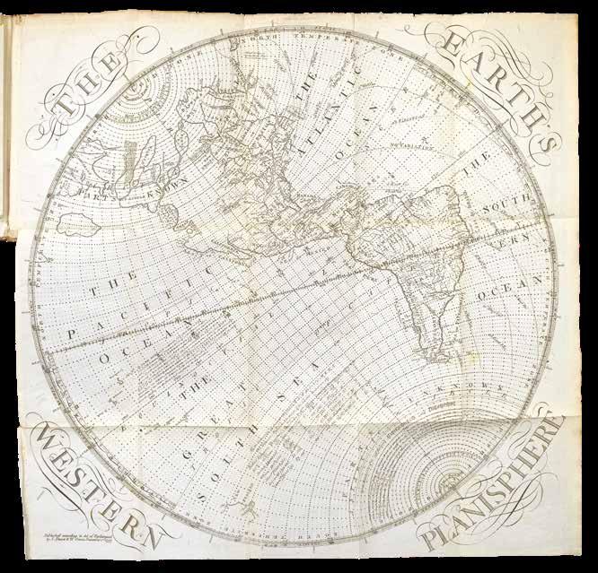
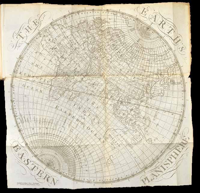
The Description and Use, of the Universal Planispheres; or terrestrial and celestial globes in plano...
Publication
London,
Description
8vo
$10,000.00
Samuel Dunn’s rare work on his invention: the universal planispheres.
Samuel Dunn (d.1794) was a British mathematician and astronomer, and was at the forefront of developments in navigation and cartography over the eighteenth century. He was an authorised signatory for ship’s masters’ certificates, a consultant to the East India Company, and had instruments and publications accepted by the Board of Longitude.
The ‘Universal Planispheres’ was published after he had become master of an academy in Chelsea which specialised in “navigation and commerce”. Dunn produced a pamphlet on the subject in 1757, and expanded on it and reissued it as this work. The book provided “an economical method of teaching spherical geometry without the expense of purchasing actual globes”. The work contains several planispherestwo dimensional maps of the terrestrial and celestial globes on what he called a ‘stereographic’ projection, mimicking the visual and mathematical properties of globes. There are two celestial and two terrestrial plates, with an eastern and western hemisphere of each. The planispheres are accompanied by a “slider”, which would be used on a planisphere in order to make calculations. Dunn was passionate about navigational education, and his work is an example of the fever gripping Britain as the longitude race continued. He was a proponent of the use of magnetic variation in order to ascertain longitude at sea, and he is mentioned several times in the minutes of the Board of Longitude between 1765 to 1772 (now housed at Cambridge University). Both the eastern and western planispheres within the present work contain the lines of magnetic variation, and on pages 152 and 153, Dunn deals with the problems of solving longitude at sea using magnetic variation.
Dunn’s book is rarely offered as a complete work, and the plates have often been extracted. There are two institutional examples in the British Library and Bibliotheque Nationale de France. The Bodleian holds a copy of the 1757 pamphlet.
SELLER, John
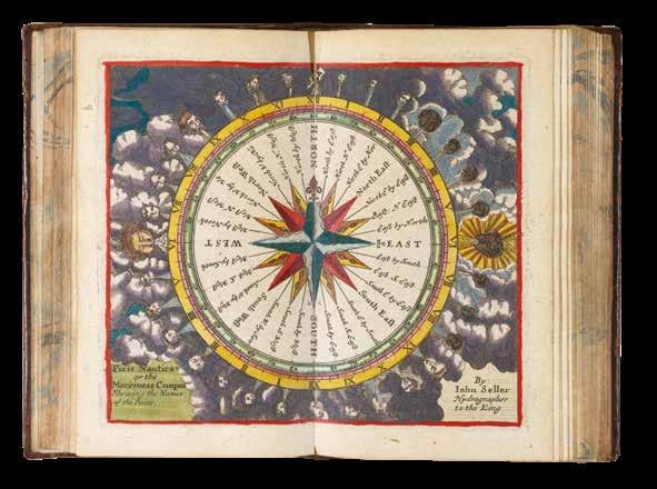
A Pocket Book containing several Choice Collections in Arithmetick, Navigation, Astronomy, Astrology, Geometry, Geography, Surveying, Measuring, Dialling, Gageing.
Publication
London: Sold by him [John Seller] at the Hermitage in Wapping and at his Shoop in Pope’s head Alley in Cornhill, [1678].
Description
Third edition, early issue, 8vo (140 by 85mm), engraved title and 71 plates and tables (some double-page, 3 with moveable volvelles and including 6 maps), coloured in a contemporary hand, 40pp. text, contemporary calf, Pease crests added in gilt, spine repaired at head and foot.
References cf. Shirley, British Library T.SELL-4a; cf. Wing S2480.
$32,000.00
Seller’s Pocket Book is a vade-mecum for English gentlemen, a compendium of useful information for every occasion, with an impressively wide-ranging series of tables including, among others, monthly almanacs, calendars, lists of the Kings of England and Lord Mayors of London, feast days, tables to calculate Easter and the full moon, tables of astronomy, trigonometry, geometry, weights and measures, and even a table to calculate how many bricks would be needed to make a wall. One of the most uncommon of the plates is a double-page engraving explaining Edward Coleman’s system of cyphers.
Two of the maps are double-page: A Mapp of the World Shewing what a Clock it is (at any time) in any part of the World, and A Traveling Mapp of England. & Dominon of Wales. The world map has an accompanying full-page leaf with rotating overlay, and both seem to have been engraved for use in the Pocket Book.
The single-page maps are of the continents (with the Americas on two sheets, North and South America), each with an accompanying engraved table of the divisions (or countries/regions), first prepared for the Book of Geography, and its later edition the Atlas minimus. These maps were also used in editions of Seller’s pocket atlases, the New Systeme of Geography [1684, and later], and Atlas Terrestris [ca. 1685, and later].
The Pocket Book is famous for its varied collations; it was first published in 1676 or 1677, and re-issued frequently thereafter to about 1707, with some of the composition due to the whim of the purchaser. For this third edition, the engraved title-page has been re-engraved, inserting Seller’s shop address at the Hermitage Stairs in Wapping, with his shop address in Cornhill dateable between 1678 and 1681.
This is an early issue of the third edition, with all but one of the monthly almanac leaves in the first state, and without the double-page engraved plates from the Atlas Coelestis [1680], found in other examples of this edition, but with the double-page plate with a table to calculate the day of the new and full moon re-engraved for the years 1680–1700 (but actually only showing 1680 to 1692), this accomplished simply by engraving over the superfluous left hand columns.
Provenance: Lord Wardington (1924-2005), bookplate.

[Anonymous]
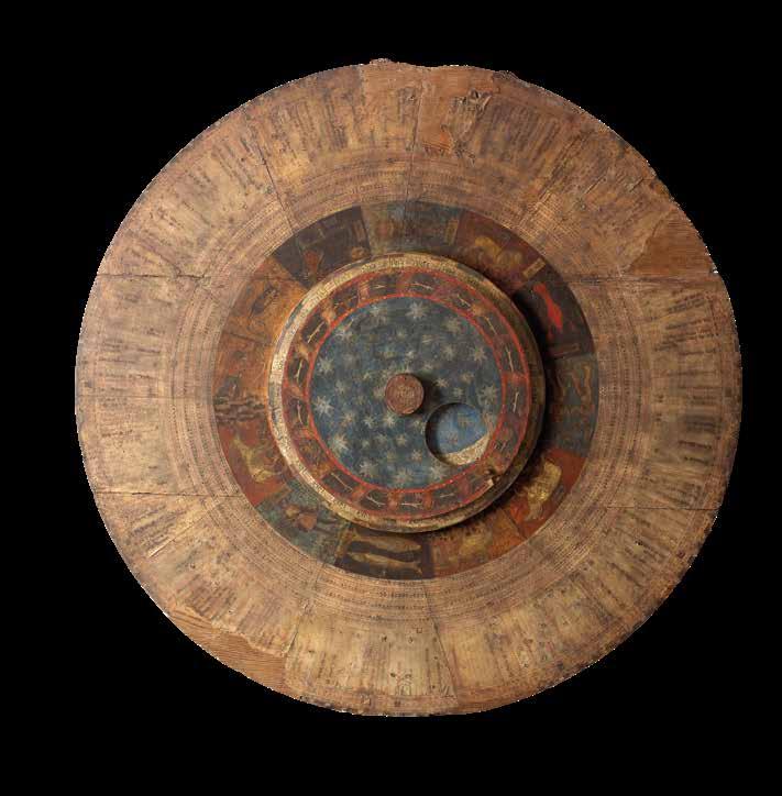
[The San Zeno Astrolabe].
Publication
[Verona, cloister of San Zeno, c1455].
Description
Illuminated manuscript with superb paintings of astrological signs, three discs connected by a central spigot, with vellum laid over pine, the main disc 1280mm in diameter, the smaller two 533mm and 483mm respectively, calendar entries on outermost edge of main disc in black and red in a fine late gothic hand, enclosing nine columns of figures in arabic numerals arranged in continuous circular tables in black and red, twelve large miniatures of the astrological signs, approximately 100mm high, arranged in a circle, smaller disc with three columns of figures in Arabic and roman numerals and names of months, central disc painted with the night sky enclosed within a ring of foliage sprigs encircled by ribbons, designed with a circular hole offset to reveal phases of moon on panel below, spigot-head decorated with a painted 6-petalled flower, undersides of discs and verso with leaves from fifteenth-century choirbooks laid on. Vellum a little frayed in places at edges of discs with some losses, two notable cracks in wood, some scratches and scuffing, faded and somewhat discoloured.
Dimensions
1280 by 1280mm (50.5 by 50.5 inches).
References
Apart from Biancolini’s brief 1757 description, there appears to be only one published account of the calendar, now almost a century old, which has rarely been referred to in print:
A. Avena and G.V. Callegari, “Un calendario ecclesiastico veronese del secolo XVo”, Madonna Verona, Anno XI, n.1: fascicolo 41 (Gennaio–Giugno, 1917), pp.1–33.
$1,540,000.00
A unique calendar, and the only object of its type to have survived from the Middle Ages.
Wall mounted and hanging for over three centuries in the cloister of the Benedictine abbey of San Zeno, Verona, it was the primary timekeeper for the monks who saw and used it daily to organise their devotional schedule. Its three dials can be rotated by hand and chart the phases of the moon, the zodiacal calendar of the stars, the amount of daylight occurring in any given day of the year, and the feast days and times of the Saints to whom the monks intended to pray.
Introduction
For at least three centuries this remarkable object hung on the wall in the cloister of the abbey of San Zeno, and it was placed in such a way that it would have been seen by all of the monks several times each day: as they left the dormitory for Matins at about midnight and as they returned to bed, as they returned to the church in the morning, and when they retraced their steps again to go back to bed in the evening. It would have been the monks only way of telling the time – it was, in effect, their clock – because it told them what time the sun rose and set each day, how many hours of light and darkness there were, changing with the seasons, and thus allowed them to tell the time based on sunrise, sunset, and the position of the sun in the sky.
Datable to about 1455 – within a year of the printing of the Gutenburg Bible – the Calendar marks the transition from the Middle Ages (generally considered to have ended around 1500 in northern Europe) to the Renaissance (generally considered to have begun about 1400 in Florence). As an object it is essentially medieval in character, yet the artist of the Zodiac illustrations was decidedly Renaissance in style.
It is also the major witness to the continued tradition of astronomical observation at Verona in the fifteenth century, a tradition that dates back to Pacificus (died 844), who invented a primitive form of astrolabe for telling the time during the night at Verona Cathedral.
To understand the San Zeno Calendar one needs first to understand a little about medieval time-keeping in general, and specifically about time-keeping within a Benedictine monastery. Astronomy and religion were inextricably linked in the Middle Ages: the date of the most important feast of the Christian ecclesiastical year, Easter – and every other feast whose date depended on it, such as Lent and Pentecost – was based on the variable date of a full moon occurring in March or April. Thus at the very least Church authorities needed to be able to predict in advance the relationship between the phases of the moon and the 365-day year.
Questions of astronomical time-keeping were therefore crucial, and some of the greatest minds applied themselves to the problem, including the venerable Bede in the eighth century. But, even today, the Eastern Church celebrates Easter on a different date than the West, due to differences in how the dates were calculated in the early Middle Ages.
Daily life in any Benedictine monastery, including San Zeno, was dictated by the liturgical ‘hours’ (called Matins, Lauds, Prime, Terce, Sext, None, Vespers, and Compline), at intervals of about three hours from about midnight until about 9pm the next evening; so seasonal variations in the length of the day and night were also of fundamental concern.
As early as the fifth century BC it had been realised that although the solar year and the lunar month did not correspond neatly with one another (discussed in more detail below) the relationship between them would repeat every 19 years. Thus, if one could calculate data for a whole 19-year cycle it could be re-used in perpetuity, re-starting every 19 years.
As the Middle Ages progressed astronomical observation became more sophisticated; increasingly precise instruments such as astrolabes were manufactured; and greater numbers of scientific texts were translated into Latin from Arabic and Hebrew. By the mid-thirteenth century it was possible for King Alfonso X of Castile to commission the so-called Alfonsine tables of astronomical data: not only do these tables provide data for the full 19-year cycle, but they also provide data applicable to a wide variety of different latitudes in Europe, so that wherever one was, one could look up variable seasonal features (such as the length of the day and night) for one’s own location. The tables included data for a number of cities in Italy, including Venice, which is on the same latitude as Verona.
Knowledge that features of the world and the cosmos repeat themselves regularly – including seasons, phases of the moon, and tides – led to their representation on circular devices from a very early date: perhaps the most famous circular representation of time is the carved stone Mayan Calendar (which some people believed predicted the end of the world in 2012). But different cosmological features observed cycles of different lengths: the sun appeared to repeat a cycle lasting about 365 days, while the moon had a cycle of about 19½ days. The most efficient way of representing cycles that were out of step with one another was by means of a volvelle: a device that allowed the different cycles to be represented by rotating discs of different sizes.
The Benedictine abbey of San Zeno had an illustrious history of astronomical scholarship, and it is perhaps thus less surprising that it should commission an astronomical calendar unlike any other known to have existed. We have not been able to find any reference to any other comparable medieval volvelle astronomical calendar, nor have we even found any documentary evidence that any other ever existed. The closest comparisons that we have been able to find are the famous astronomical clock in Prague, originally most of which dates from 1490, and heavily restored in more recent years; and the similar astronomical clock in St Mary’s, Gdansk, dating from the late-1460s, which was severely damaged in 1945 and subsequently heavily restored.
Content
The various columns of letters, numbers, and text, from the outermost to the innermost concentric circle, are as follows:
1. The day of the month in Arabic numerals: 1–28 (February), 1–30 (April, June, etc.), or 1–31 (January, march, etc.), according to the modern (Gregorian) calendar.; in black ink.
2. The day of the month in Roman numerals, with kalends, ides, and nones, according to the Roman (Julian) calendar; in red.
3. The Sunday Letters, “Litterae Dominicales”: the first seven letters of the alphabet A–G repeated fifty-two times for the weeks of the year, starting at A on 1 January; in black except for ‘A’s, which are in red.
4. Saints’ days and their liturgical gradings, plus a number of other astrological entries including the equinoxes and solstices, and immovable ecclesiastical entries, such as and earliest possible dates of Septuagesima and Easter; in black, with red for major feasts.
5. The Golden Numbers (16, 5, 13, 2, … 11, 19, 8) against various dates from 17 January–15 February, and letters representing the possible dates of Easter, “Littere tabulares” against 21 March–25 April with [a]–u in black and a–q in red, to be used with a table indicating the date of Easter.
6. The age of the sign of the zodiac, in arabic numerals 1–30; in red.
7. The Siderial Months, starting at 1 January, consisting of the letters of the alphabet a–z, often with one or more letters repeated and followed by the tironian symbols for ‘et’ and ‘con’, making a total of 27 or 28 days; in black.
The next three pairs of columns each give an increasingly long period of time:
8–9. The half-length of the night (i.e. from dusk to midnight, or midnight to dawn) in hours and minutes, varying from a maximum of 7 hours 45 minutes on 13–16 December (i.e. the Winter Solstice), to a minimum of 4 hours 15 minutes on 13–18 June (i.e. the Summer Solstice).
10–11. The full length of the night in hours and minutes, varying from a maximum of 15 hours 30 minutes on 13–16 December, to a minimum of 8 hours 30 minutes on 13–18 June; i.e. the lengths of night in this pair of columns are simply twice as long as those in the previous pair of columns.
12–13. The full length of the night plus half the length of the day, i.e. the length of time from dusk to the following midday, in hours and minutes, varying from a maximum of 19 hours 45 minutes on 13–16 December, to a minimum of 16 hours 15 minutes on 13–18 June.
14. Depictions of the signs of the zodiac, with two labels stuck on each (some now missing), one inscribed with the name of the sign (Aquarius, Pisces, Aries, etc.), the other with the word “Bonum”, “Indifferens” or “Malum”, indicating whether it is a good, indifferent, or bad time for blood-letting.
15–16.Of the next two concentric circles, the inner one contains column headings “Lune”, “H”[orae, i.e. hours], “M”[inuta, i.e. minutes], and “Etas” (i.e. age), and the other one contains the numbers 1–30 under the alternate Lune and Etas headings, and with hours and minutes columns with numbers rising from 0:0 to 12:0 and then decreasing back to 0:0, in increments of eight: 0:0, 0:8, 1:6, 2:4 … 12:0, 11:12, 11:4 … 1:6, 0:8, 0:0. By turning a pointer attached to the innermost disc so that it points to the age of the moon, a hole in this disc reveals a depiction of the phase of moon, from new to full and back again, with intermediate crescents showing its waxing and waning.
Artist
The artist of the miniatures has not been identified. The art historian Caterina Gemma Brenzoni of Verona University studied the calendar a few years ago in relation to the restoration of the apse of San Zeno, which contains a remarkable fresco 24-hour clock-face on a wall to the left of the altar, numbered in both roman and arabic numerals, that presumably once had a mechanism to drive an hour-hand:
Copies of her unpublished work (Ricerche inedite d’archivio e lettura storico artistica della decorazione dell’abside della basilica di San Zeno, Verona 2008-2009) are deposited with the Banco Popolare Archive, Verona, and in the Biblioteca Civica di Verona. She kindly informs us that the closest stylistic paralells that she found were Lombard painters working in the middle of fifteenth century, such as the Maestro Paroto’s Madonna and Child with Saints and Crucifixion poliptych in the Bagatti Valsecchi Museum, Milan; the famous sets of ‘Tarocchi’ (Tarot cards) by the workshop of Bonifacio Bembo (Pinacoteca Brera, Milan) and works by the Zavattari brothers, such as the frescoes in the chapel of Queen Theodolinda, Monza Cathedral, executed by Ambrogio and Gregorio Zavattari in 1444.
There is ample liturgical evidence that the calendar was made for the use of the Benedictine abbey of San Zeno, Verona.
The highest grade (“Duplex maius”) feasts include:
21 March: Benedict, founder of the Benedictine Order
12 April: The Deposition of Zeno, bishop of Verona
21 May: The Translation of Zeno
8 December: The Ordination of Zeno
10 December: The Dedication of the Basilica of San Zeno
The next highest (“Duplex minus”) feasts include:
28 March: The Octave of Benedict
5 September: Crescentianus, bishop of Verona
The next highest feasts (with 12 readings) include:
23 March: Proculus, bishop of Verona
29 April: Peter Martyr, who was born in Verona
22 May [added:] Lupicinus, bishop of Verona
13 July: Anthony Abbot, “the father of all monks” and probably (but the grading is damaged)
31 October: Lucillus, bishop of Verona
The calendar is recorded attached to a wall in the cloister of San Zeno in the mid-eighteenth century: Giambatista Biancolini, Dei Vescovi e Governatori di Verona [Bishops and Governors of Verona] (Verona, 1757), p.22, in a section discussing the former bishop of Verona St Lupicino, has the following passage:
“Curioso Calendario si sta annicchiato nella parete della Loggia che dal Dormitorio del Monistero Zenoniano conduce al Coro e alla Sagristia di quella Chiesa. Codesto Calendario è molto bello, ampio ed esatto, scritto sopra carta su di una tavola sferica che si può girare attorno per comodo de’ leggittori, e vi su posto del 1455. per uso degl’ istessi Monaci di San Zenone. Nel medesimo de’ nostri santi Vescovi si leggono S. Procolo, S. Lucillo, S. Zenone e S. Cerbonio solamente. Ma non fi sa il perchè vi manchi S. Lupicino, il cui sacro Corpo insieme con quelli di S. Lucillo e del Martire S. Crescenziano (il qual S. Martire nel detto Calendario si sta eziandio registrato) per tempo immemorabile nella suddetta Chiesa si riposa, mercecchè in un Catalogo de’ nostri Santi Vescovi in un Codice Miscellaneo della Librerìa Zenoniana, più antico del suddetto, standosi registrato il nome del suddetto Santo, vi su al nome medesimo da mano più recente aggiunto: cujus Corpus in Ecclesia S. Zenonis.”
This may be loosely translated as:
“A curious calendar is tucked into the wall of the loggia which leads from the dormitory of San Zeno monastery to the choir and the sacristy of the church [i.e. the East side of the Cloister]. This calendar is very beautiful, large, and accurate, written on paper [sic] on a circular panel that it is possible to rotate for the convenience of readers, placed there about 1455 for use of the monks of San Zeno. In it one can only read the names our sainted bishops San Proculo, San Lucillio, San Zeno and San Cerbonio. But it is unknown why it lacks San Lupicino whose sacred body, together with those of San Lucillo and the martyr San Crescenziano (who is recorded in the said calendar) rests in the said church since time immemorial, since in a list register of our sainted bishops in a miscellaneous codex in the library of San Zeno, the oldest of the latter, is recorded the name of the said saint, by whose name is added in a more recent hand: ‘whose body is in the church of San Zeno’”.
If Biancolini is correct about the date of the placement of the calendar in 1455 (he must have had information no longer available, perhaps an inscription painted on the wall of the cloister, or perhaps a document in the abbey archives, now lost) then it was doubtless commissioned by Gregorio Correr (1409–64), who was Abbot of San Zeno from 1448. A somewhat earlier date than 1455 is perhaps suggested by the absence of the feast-day (20 May) of St Bernardino of Siena, however: he died in 1444, was canonized in 1450, and the feast was quickly adopted by liturgical calendars throughout Italy.
San Zeno was plundered by Napoleonic troops in 1797, one result of which is that the three predella panels of Mantegna’s San Zeno Altarpiece, commissioned by Abbot Correr and painted c.1457–60, are today at Paris in the Louvre and at Tours in the Musée des Beaux-Arts.
By the early twentieth century the calendar was the property of the Conte Antonio Maria Cartolari of Verona (born 1843 - see Vittore Spreti, Enciclopedia storico-nobiliare italiana: famiglie nobile e titolate viventi riconosciute …, II (1929), pp.344-5.), and it may have entered the noble family’s collection during the Napoleonic upheavals through one of their ancestors: they are recorded as owning a portrait of an ancestor called Bartolomeo who was a monk of San Zeno (Inscribed “Bartholomaeus de Fanzago Cartulariis, S. Zenonis Majoris Ver. Cenobii Monachus filius Io[hannes] Baptistae e consilio Nobilium gubernatoris S. Montis Pietatis”; see Avena and Callegari, p.29). It is not known exactly when the Calendar left the Cartolari family collection (Conte Antonio Maria was born in 1843, married in 1869, and was apparently still alive in 1929 - when the Enciclopedia cited above was published - but was dead by 1943 unless he lived for more than 100 years.), but a portrait of a Woman with Green Vest, White Blouse and Red Choker by Pietro Antonio Rotari was sold by the descendants of the Conte Antonio Maria Cartolari in the 1970s, and is now in the Norton Simon Museum, California.
Provenance:
1. Benedictine monastery of San Zeno in Verona;
2. which was plundered by Napoleonic troops in 1797; by descent through thenoble Cartolari family; to the Conte Antonio Maria Cartolari of Verona (born 1843 - after 1929).
VOOGHT, Claes Jansz. [after] Jan Jansz STAMPIOEN
Onderwysing van’t Gebruyk des Hemels Pleyn Waar op de starren des hemels na ’t oogh in ’t plat gestelt zyn[.] Tot nut en vermaak van alle liefhebbers der wiskonsten.
Publication Amsterdam, Johannis van Keulen, [c16801696].
Description
Large engraved celestial chart with a rotating printed paper ring (volvelle or rete) on an off-centre axis to indicate the part of the sky visible at any date and time and to make a variety of celestial calculations, all for the Netherlands’ latitude of 52 degrees. A string with two beads serves as a pointer for aligning the scales in the stationary and rotating parts. With engraved instructions also by Vooght. Coloured by a contemporary hand and mounted on contemporary boards covered with marbled paper, apparently by the publisher, so that it can be folded in half for carrying. The string may be a modern replacement.
Dimensions 560 by 660mm. (22 by 26 inches).
References
Bierens de Haan 5117?; Bom, Bijdragen ... Van Keulen, appendix B, p. 21?; Cat. NHSM, p. 640; E.O. van Keulen et al., “In de Gekroonde Lootsman,” item 4 & illustration between pp. 64 & 65 (NHSM copy); Koeman IV, Keu 28, map 6, p. 5 & p. 370, item 272 (without volvelle); Tiele, Land- en Volkenkunde 593 note; De Vries, et al., Van Keulen Cartography, p. 207, item 240; Warner, Sky Explored, p. 260, items 1 & 1a; Adler Planetarium on-line database A-286; cf. V.d. Krogt, Advertenties 130 (1696 ed., pub. by Loots); not in BMC Printed Maps; Cat. Nat. Mar. Mus.; Nordenskiöld; Zinner, Astron. Instrumente; NCC/Picarta; OCLC WorldCat.
$30,000.00
Vooght’s rare star chart and astronomical calculator, here separately issued in portfolio form and in its first state.
The chart shows the stars visible from 52 degrees latitude in a polar equidistant projection, with a rotating volvelle or rete to indicate the part of the sky visible at a particular moment. The circular border around the sky image and the outer part of the volvelle include scales with several kinds of data so that the chart can be used for various purposes. One can use the string to align the time in the volvelle with the date in the border of the chart, so that the part of the sky visible at that moment appears inside the volvelle. The chart with its volvelle, scales and string can also be used to calculate times for the rising and setting of constellations at various dates (or to calculate the present time based on the position of the stars). Fifty-three constellations are numbered quarter by quarter (15, 9, 14, 15), with a Dutch key identifying them in each corner and a French and an English translation in strips of panels at the head and foot. The instructional text, describing six “proposals” (the first explaining the different scales, etc., and the others giving examples of the use of the chart), stands to the right of the chart itself, and with the text were printed together from a single plate. If the ring is turned with 12 midnight to the right, the boards can be folded to each other like a portfolio, protecting the chart and making it easier to carry. It appears to have been published in this form, for the copy at the Dutch Maritime Museum in Amsterdam is similarly coloured and mounted to make a similar marbled portfolio. The only other complete copies we have located, at the Boerhaave Museum in Leiden and the Adler Planetarium in Chicago, are also in portfolio form. Though designed for use at a latitude of 52 degrees, the text suggests it remains accurate from 49 to 55 degrees, which would allow its use through much of northern Europe.
Although astrolabes had long used a rotating off-centre ring to denote the part of the sky visible at a given time, such a ring combined with a planispherical star chart (like the cardboard or plastic star finders still popular today) often is supposed to be a nineteenth-century invention.
Jan Jansz. Stampioen’s 1664 chart seems to be the earliest well-documented chart of this kind, though some suppose his father’s ‘Coelestum Planum’, mentioned in a 1619 patent and documented in 1621, was such an instrument, and Kepler’s son-in-law, Jakob Bartsch, is also said to have made something similar. Vooght clearly based his chart on Stampioen’s 1664 edition, published by Hendrik Doncker with text by Dirk Rembrandtsz. Van Nierop. Neither it nor the 1684 version (also apparently published by Doncker) is known to survive (unless the latter was the chart alone, without volvelle or instructive text), so that Vooght’s version in its present first state is the earliest known example. Comparison with a c. 1722 edition printed from Doncker’s original plate suggests that Vooght followed Stampioen closely, with the same 53 constellations (the latest introduced by Mercator and Plancius in the sixteenth and early seventeenth centuries) and the text in the corners describing them copied word for word and line for line.

In 1678/79 Van Keulen (1653/54-1715) set up at the address in the present chart (at the sign of the Crowned Pilot, opposite the new Bridge) and in 1680 he and Vooght (c. 1637?-1696) began to publish their charts with the privilege granted then, and re-granted to cover the years 1695 to 1710. The chart in its present first state must date between 1680 (since it notes the fifteen-year privilege) and 28 August 1696 (four months after Vooght’s death), when Johannes Loots described Vooght’s chart as new in an advertisement for his edition, also separately issued, his instructional text (by Simon van de Moolen, not mentioned in the advertisement) appears on a separate slip pasted over the engraved text, so his edition must be later than Van Keulen’s. The present chart, moreover, makes no reference to Vooght’s 1696 death. The chart is also mentioned in a list of Van Keulen publications in the ‘Zee-Fakkel’ (Bom, not specifying the edition), though supposedly including Spanish text, presumably for the constellations (Bierens de Haan probably based his description on the same advertisement). The instructional text notes that the stars are depicted in accordance with the year 1700 (“na haar waare stand en rangh afgebeeld, zijnde geschikt na ‘t Jaar 1700”), but such charts were often calculated for a round-numbered year a few years in advance. The chart later appeared in some copies of Van Keulen’s atlases, though without volvelle in the only example we have located: his 1708/09 ‘Zee-Atlas’ (part I) at the Dutch Maritime Museum in Amsterdam (Koeman IV, keu 28, map 6: De Vries appears to err in citing a copy in Koeman IV, keu 110B, the 1709 ‘Zee-Fakkel’ at the Amsterdam university Library; and the Cat. nhSM , p. 50, errs in citing a copy in a 1684 edition of the ‘Zee-Atlas’). Thiele reports a copy in a 1681/1686 atlas, not now located. In numerous Van Keulen atlases from 1682 to 1695, Koeman reports two versions of a different celestial chart, but not this one.
STAMPIOEN, Jan Jansz the Younger, [and] Marten CALMAM
Onderwys in ‘t Regte Gebruyk van het Hemels-Plyn strekkende tot nut en vermaak der liefhebbers.
Publication Amsterdam, Jochem Hasebroek, [c1722].
Description
Large engraved celestial chart by Stampioen with a rotating printed paper ring (volvelle or rete) on an off-centre axis to indicate the part of the sky visible at any date and time and to make a variety of celestial calculations, all for the Netherlands’ latitude of 52 degrees. With letterpress instructions by Calman on a separate slip at the right. The sky image 33 cm in diameter; the whole chart with the letterpress slip as mounted 49 x 61.5 cm. A string with a bead serves as a pointer for aligning the scales in the stationary and rotating parts. Coloured by a contemporary hand and mounted on contemporary boards covered with marbled paper, apparently by the publisher, so that it can be folded in half for carrying.
Dimensions
500 by 630mm. (19.75 by 24.75 inches).
References Koeman IV, p. 5 (no location noted; cf. p. 153); Warner, Sky Explored, p. 260, no. 1c (no location noted; cf. p. 247); Alder Planetarium on-line database A-259; cf. Bierens de Haan 4516 (1684 ed., not seen: see his Bouwstoffen II, pp. 386 & 429 note 5); E.O. van Keulen et al., “In de Gekroonde Lootsman,” item 4 & illustration between pp. 64 & 65 (1680/1696 Vooght/ Van Keulen ed.); not in BMC Printed Maps; Zinner, Astron. Instrumente; NCC/Picarta; OCLC WorldCat.
$30,000.00
Telling the time with stars
The chart is here in its third state, but we have located no complete example of any earlier version. The Boerhaave Museum in Leiden has the chart without volvelle or instructional text, published by Doncker, but the 1664 edition described in Doncker’s advertisement clearly included the volvelle and instructional text. Perhaps the surviving chart is the 1684 version mentioned but not seen by Bierens de Haan, who provides neither a detailed description nor a source for his information. They and the present version (printed from Doncker’s plate c1722) seem to have appeared only as separate publications, hence their great rarity. The circular border around the sky image and the outer part of the volvelle include scales with several kinds of data so that the chart can be used for various purposes. One can use the string to align the time in the volvelle with the date in the border of the chart, so that the part of the sky visible at that moment appears inside the volvelle. The chart with its volvelle, scales and string can also be used to calculate times for the rising and setting of constellations at various dates (or to calculate the present time based on the position of the stars). Fifty-three constellations are numbered quarter by quarter (15, 9, 14 and 15), with a Dutch key identifying them in each corner. Calman’s instructional text, printed letterpress on a separate slip (495 by 185 cm) and mounted to the right of the chart itself, describes the different scales, etc., then presents nine “proposals” (giving examples of the use of the chart). If the volvelle is turned with 12 midnight to the right, the boards can be folded to each other like a portfolio, protecting the chart and making it easier to carry. It may have been published in this form, for the only other copy located, at the Adler Planetarium in Chicago, is similarly mounted. The marbled paper covering the portfolio, similar to Wolfe 33-35, was common in the Netherlands in the late seventeenth and early eighteenth centuries. In the plate of the star chart itself is engraved, “Auct. J. Stampioen. ‘t Amsterdam by Iochem Hasebroek” but Hasebroek’s name is larger and in a different style than the rest of the lettering, and one can see traces of an earlier name under it. Although the older name cannot be deciphered, one can see that “Hendrick Doncker” would fit (with traces of the h and Do, and marks where the ascenders to the d, k and k would have been), making it clear that the present chart is printed from Doncker’s original plate. Calman advertised his Amsterdam boarding school for calligraphy, mathematics, etc. in 1722, and Hasebroek (1682- 1756) is recorded as a sea chart publisher and instrument maker from 1714 to 1743.
Planispherum Lunare cujus ope Locus medius Solis Lunae, ejusdemque Nodorum, Solis Declinatio, Lunaeque Latitudo Simplex, atque ejus Argumentum, necnon Novitunia et Plenitania Ecliptica simul inveniuntun.
Publication [c1800].
Description
Ink and polychromy on paper over pine. The instrument comprises a circular base plate, and three rotatable cardboard volvelles, and a brass radius pointer, attached to each other in the centre. A brass ring is attached to the base plate for suspending. All four paper covered discs are finely inscribed in manuscript with various scales and symbols.
Dimensions
470mm in diameter.
References
Oxford Dictionary of National Biography; Webster, Roderick and Marjorie, ‘Western Astrolabes’, Adler Planetarium & Astronomy Museum, 1998; Museo di Storia della Scienza, Florence, Italy
$25,000.00
A unique manuscript lunar astrolabe
Content
1. The smallest volvelle bears a scale covering 12 hours on its outer ring. It also shows the ecliptical motion of the Sun, the Moon’s orbit, the line of nodes, and the arguments of latitude (in other words, the distances from the nodes).
2. On the second volvelle, a scale covers the years from 1801 to 1825. Each year is subdivided in twelve months, with the abbreviated name written for each month.
3. The following volvelle carries a series of scales showing a monthly calendar, a zodiac calendar with skilfully drawn pictures and the symbols of the signs. Below the zodiac is a scale for the declination of the sun throughout the year, set in four sequences of three.
4. On the outside rim of the volvelle is another calendar scale in which the months are unevenly distributed. This scale presumably was to be used in conjunction with the outer scale on the circular base plate. In addition, the volvelle holds two brass studs that most probably helped the user turn the disc to the desired position. This latter scale gives the days, subdivided in hours. The days are numbered I to XXXI, with the number I coinciding with XXVII and 8 hours (the sidereal period of the Moon), which results in a double numbering from XXVIII to XXXI. Below this scale for days, there is a series of dates, all confined to the period 1801 to 1825, presumably for solar eclipses. The brass rule or pointer holds a horizontal scale from 5 to 0 (LA-southern declination) and from 0 to 5 (LB-northern declination), indicating the latitude of the moon with respect to the ecliptic. The closer to 0 at new moon or full moon, the likelier an eclipse is to occur. The rule is engraved with “Locus Lunae”. The circular scales serve to set the moon’s position and node relative to the sun, from which the user can then infer the lunar phase and whether an eclipse will occur at new moon or full moon.

BLAEU, Willem Janszoon
[Pair of nine-inch table globes].
Publication
Amsterdam, 1602 [but c1621].
Description
Terrestrial and celestial globes, each with 12 hand-coloured engraved gores heightened in gold, with two polar calottes, over a papier mâché and plaster sphere, rotating on brass pinions within a brass meridian ring with graduated scale, and a graduated brass altitude quadrant, set into a seventeenth century Dutch wooden base with an engraved horizon ring, adumbrating scales, calendar, almanacs etc. With usual defects: paper equinoctial tables present gaps that are filled and restored, small splits along the gores, several partially deleted entries, small scattered spots but in general in good condition for such an early globe pair, modern hour circles and pointers.
Dimensions
Diameter: 230mm (9 inches).
References
Dekker GLB0152, van der Krogt, Globi Neerlandici BLA III; GLB0083 (terrestrial) and GLB0151 (celestial).
$380,000.00
Biography
Willem Janszoon Blaeu (1578-1638) started “one of the most successful publishing houses of the seventeenth century” (Dekker). Originally trained in astronomy, he quickly became a leading maker of maps, atlases and instruments. At the time the Low Countries hosted the best cartographers in Europe, and Blaeu produced ever more accurate and more beautiful globes, spurred by his rivalry with fellow Dutch cartographer and publisher Jodocus Hondius.
Blaeu’s globes were luxury items for wealthy and intellectual merchants and nobility who benefited from Blaeu’s access through the Dutch East India Company to the latest navigational discoveries and geographical information. As van der Krogt observes, “During the preceding century, more than half of the known world, including the entire western hemisphere, had been charted and, more recently, during Blaeu’s own time, large portions of the Pacific were being explored”. Dutch explorers had played a key role in the expanding European worldview: from Olivier van der Noort’s circumnavigation of the earth, to Willem Barentsz’s attempts to find the Northeast Passage. Blaeu also had the advantage of considerable personal technical skill: he studied under the astronomer Tycho Brahe to create a star catalogue for his first celestial globe.
Blaeu’s pair of 230mm (9 inch) table globes are amongst the rarest to survive in comparison with the smaller or larger globes by Blaeu (100, 150, 340 and 680mm; 4, 6 13.5, and 26 inches).
Geography
Willem Jansz Blaeu (1571-1638) collected information that Dutch mariners gathered from around world and brought back to Amsterdam. Crews were instructed to record information about the lands they visited and the skies they saw. Blaeu incorporated these observations in maps and globes. Through his web of contacts and thanks to assiduous research, he was also able to obtain the most recent information about the latest discoveries in the western hemisphere and the South Pacific, where Dutch explorers were particularly active at the time.
Since the globe was published after 1618, Blaeu was able to include the discoveries made by Henry Hudson in his attempt to find a passage to the East Indies. He also included recent Pacific discoveries of the celebrated voyages of Willem Cornelis Schouten and Jacob Le Maire, who both traversed the South Pacific and the Atlantic in 1616. The findings of Schouten and Le Maire in the Tierra del Fuego region are also incorporated.
The Strait of Le Maire is drawn and the hypothetical southern continent is labelled “Terra Australis Incognita Magalanica”. Olivier van Noort’s track is drawn and labelled. His route is indicated with a broken line and the words: “Navigationis Olivierij ductus” (several times). There are various decorative features, such as animals on the different continents, many ships on the high seas and allegorical and mythical figures around the cartouches.
The nine-inch globe is not just a smaller version of the one published in 1599. Drawings of animals and people do often correspond to those on the earlier globe, but Blaeu made several significant changes.
- The west coast of North America is drawn differently and the river system of Brazil is altered.
- The hypothetical southern continent is labelled: Terra Australis Incognita Magalanica.
- There are nine ocean names in handsome curling letters: Mare Congelatum, Mare Atlanticum, Oceanus Aethiopicus, Mare Arabicum et Indicum, Mare di India, Oceanus Chinensis, Mar del Zur, Mare Pacificum, Mar del Nort.
- Willem Blaeu, always eager to display the latest discoveries, traced the route of Van Noort’s route with a broken line. The findings of the voyage of Schouten and Le Maire in the Tierro del Fuego region are included, despite the 1602 date (names: Fr. Le Maire, Mauritius, Staten Landt, C.Hoorn, I.Barneveltij).
Astronomy
The first maker of globes from the northern Netherlands was the cartographer Jacob Floris van Langren (before 1525-1610). He published his first terrestrial and celestial globes in 1586 with a diameter of 325mm (12.75 inches) the terrestrial globes being based on the work of Mercator. The second edition of the celestial globe was improved after the observations of the southern hemisphere by Pieter Dirkz Keyser and Frederik de Houtman were incorporated by the geographer Petrus Plancius (1552- 1622), who was also influential as a globe maker.
Two other famous Dutch mapmakers produced celestial globes: Jodocus Hondius the Elder (1563-1612), one of the most notable engravers of his day, and Willem Jansz Blaeu (1571-1638).
Publication history
According to Peter van der Krogt, the following states are known:
Terrestrial
First state: 1602 (no known examples).
Second state, c1618-1621 (no known examples).
Third state: 1602, but c1621 (the present example).
All the states are dated 1602 but the second state must have been published after 1618, since it includes the discoveries of Schouten and Le Maire (1615-1617), but not the name “Blaeu”. Dekker makes no distinction between the different states. The third state can be divided into states 3a and 3b. All globes have a different production number, some of which are illegible today. This terrestrial nine-inch globe is marked with “fabr. nr. 4”.
Celestial
First state: 1602 (known in a catalogue record but no known example surviving).
Second state: presumably published after 1621.
All 30 known celestial globes are in the second state, as this one, which is marked with “fabr. no. 12”. Rare: there are 19 recorded pairs, of which 14 are in institutions.
PLANCIUS, Petrus
In hac coelestis Sphaera stelle Affixae majore. De integro addidi: quae omnia secundum
Astronomorum Principis Thyconis
Brahe... observationem verae suae Longitudini, ac Latitudin.
Publication
Petrus Plancius, 1625.
Description
Globe, 12 hand-coloured engraved gores, over a papier ma âche é and plaster sphere, with metal pins, supported by a wooden structure of four arms with a circular band with partially applied graduated paper, set into a modern wooden base.
Dimensions
Diameter: 245mm (9.75 inches).
References van der Krogt KEE I; Science Museum Group 1986-427; for reference see Stevenson vol. II, pp.46-50.
$85,000.00
Biography
Petrus Plancius (1552-1662), a theologian and geographer, was one of the most influential cartographers of his day. He was forced to flee to Amsterdam in 1585, for fear of persecution as a Protestant minister. There he began his cartographical career, studying Portuguese charts and becoming friends with the explorer Henry Hudson. He issued his impressive world map in two hemispheres entitled ‘Nova et exacta terrarum orbis tabula geographica ac hydrographica’ in 1592, which likely influenced both Blaeu and Hondius in the preparation of their masterpieces published in 1605 and 1611, respectively.
In addition to his world map, Plancius turned his eyes to the skies. In 1589, he collaborated with the Amsterdam cartographer Jacob Floris van Langren on a 325mm (12.75 inches) celestial globe incorporating the limited information available about southern celestial features, which included Crux (the southern cross), Triangulum Australe (the southern triangle) and the Magellanic Clouds (Nubecula Major and Minor).
On a quest to expand knowledge of the southern hemisphere, Plancius commissioned Pieter Keyser, to record as many southern stars as possible on his voyage of the Indies in 1595. Although Keyser died at sea in 1596 before his return, he was able to record about 130 stars alongside his colleague Frederick de Houtman, and the records reached Plancius when the surviving voyagers returned. Plancius took these new discoveries and divided the stars into 12 new southern constellations, which mostly referred to animals and subjects described in natural history books and travellers’ journals of his day. The constellations are: Apis the Bee (later changed to Musca by Lacaille), Apus the Bird of Paradise, Chamaeleon, Dorado the Goldfish (or Swordfish), Grus the Crane, Hydrus the Small Water Snake, Indus the Indian, Pavo the Peacock, Phoenix, Triangulum Australe the Southern Triangle, Tucana the Toucan and Volans the Flying Fish.
Plancius plotted these southern constellations on a 350mm celestial globe in late 1597 (or early 1598) in collaboration with the Amsterdam cartographer Jodocus Hondius the Elder. No copies of this globe survive, but in 1602 Blaeu produced a copy of the globe, now in the Maritime Museum.
These constellations, together with the constellation Columba that Plancius included on his 1592 map of the world, were then incorporated by Johann Bayer in his sky atlas of 1603, the ‘Uranometria’.
Plancius created another globe in 1612-1614, published in co-operation of Pieter van den Keere with updated celestial cartography. The celestial globe is inscribed with the following: “In hac coelesti sphaera stellae affixae majore quam hactenus numero ac accuratiore industria delineantur. Novos Asterismos in philomatheom gratiam de integro addidi: quae omnia secundum Astronomorum Principis Tychonis Brahe, ac meam observationem verae suae Longitudinis ac Latitudinis ad annum Christi 1615 restitui. Petrus Plancius” (translation: “In this celestial sphere the fixed stars to a greater number than previously and with more exactness are depicted. I have added for the use of the student some entirely new star readings according to the prince of astronomers Tycho Brahe, and also my own observations of their true latitude and longitude adapting these to the year of Christ 1615. Peter Plancius”). Plancius includes a portrait of Tycho Brahe in the southern hemisphere. On this updated globe, Plancius introduced the following eight constellations: Apis the Bee, Camelopardalis the Giraffe (often interpreted as a Camel), Cancer Minor the Small Crab, Euphrates Fluvius et Tigris Fluvius the Rivers Euphrates and Tigris, Gallus the Cock, Jordanis Fluvius the River Jordan, Monoceros the Unicorn and Sagitta Australis the Southern Arrow. Of the latter constellations, only Camelopardalis and Monoceros are still found on modern star charts, and recognized by the International Astroninomial Union (IAU).
Astronomy
The names of the constellations are given in Latin along with alternative names, some in Greek. The 48 Ptolemaic constellations appear along with Antonious, Coma Berenices, Cruz (“Cruzero Hispanis, at Ptolomeo Pedes Centauri”), and Columba (“Hemame. Columba Noachi”). The 12 constellations of Plancius appear as well as a number of contellations that appear on the globe for the first time: “Apes”, “Gyraffa Ca-melopardalis”, “Monoceros, Callus”, “Cancer minor”, “Jordanis fluv:”, “Sagitta Aust:” and “Euphrates fluv en Tigris flu”. The magnitude chart is drawn and labelled “Magnitudo Stellarum”. One nova is shown and is labelled with the following notation: “Stella mirabilis quae insolito prae alijs fulgore a[nn]o 1571 per an[num] et tri-entem appa-ruit” (translation: The wondrous star, which shone with an uncommon shine compared to the others in the year 1571 for one and one-third years”.
A portrait of Tycho Brahe appears below the figure of Cetus.
DELLA VOLPAIA, Girolamo [Armillary sphere].
Publication Florence, 1598.
Description
Gilt brass Ptolemaic armillary sphere, signed under the horizon ring, ‘Hieronymvs Vvlparia Floren(ti)nus Faciebat
A.D.M.D.LXXXXVIII’; brass, with wooden Earth sphere, set in a brass horizon ring on a turned wooden base, the horizon ring, divided to each degree in four quadrants of 90 degrees each, attached by two arcs attached to a tapering post which fits into the base, the top of which is prevented from splitting by a decorated brass ring; the horizon ring engraved in Latin with the names of the thirteen winds, the rotatable sphere supported within the horizon ring by a meridian ring, two great circles through the equinoxes and the solstices on the ecliptic circle,with the signs named, earthsphere axis with solar and lunar rings, turned fruitwood base.
Dimensions
200 by 120mm. (7.75 by 4.75 inches).
$60,000.00
