7 minute read
Terra Australis Cognita

- The Robert Clancy Collection, part I
Maps are the textual record of discovery. Our collection reflects discovery and development of continental masses contained within the southern hemisphere over a period ranging from 1482 to 1960: from the time of the first printed map that showed a shift in Ptolemaic thinking about world order (Ulm Ptolemy, 1482), to the third edition of the map “Antarctica” 1:10 million (ANARE, 1960) recording completion of the Antarctic treaty (1959).
This year represents for us 50 years of map collecting, and the maps in this catalogue were acquired at the beginning of this period – a time when an itinerant immunologist on an academic salary could wander into any of several “map shops” no matter which city he was in and view a selection of pre-Cook maps relevant to Australian discovery. And even buy some. A luxury no longer possible.
When I worked at MacMaster University in Canada, I met Ken Kershaw – the prototype “unforgettable character” whose passion for antique maps became my contagion. Ken taught me about map auctions and introduced me to the dealers of the day in London and Amsterdam. The core maps of the collection came from Mr C. Broekema, a map dealer in Amsterdam (I never did know what the “C” stood for, but I became a regular visitor to 28 Titian Straat). The centre for antique maps shifted to London which became a spiritual home: Clive Burden, Doug Adams and Jonathon Potter became my early map mentors and of course sources of maps. I wrote “The Mapping of Terra Australis” to include the information I could not otherwise find as a neophyte searching for guidance in construction of an Australian collection (many of the maps in this catalogue are illustrated in that book).
Later IMCoS with its annual June Map Fair and International meetings, filled information voids while providing life-long friendships based on a mutual love of old maps.
Robert Clancy

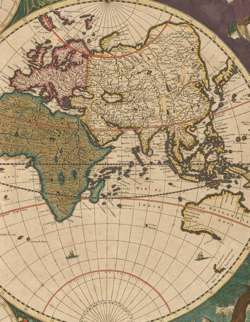
In antiquity, the earliest geographers and cartographers hypothesised a southern landmass to balance out the northern hemisphere, and when, in the second century, Ptolemy asserted that the Indian Ocean was bounded by land to the south, the legend of a terra australis incognita was born. This ‘unknown southern land’ appears on early maps in various imprecise forms, running along the complete lower border of Münster’s 1552 world map (item 2), the Ulm 1482 world map (item 3), and that in the Nuremberg Chronicles from 1493 (item 4).
The great voyages of Columbus in 1492, de Gama in 1497, and Magellan in 1520 caused an important shift in the understanding of world geography, and thereby precipitated the modernisation of cartography, especially in the form of sea-charts. Münster’s ‘modern’ map of the world (item 6) is testament to the importance of these early exploration in updating and refining geographical knowledge. Such expeditions provided scant evidence about the fabled terra australis, however, and mapmakers were often forced to use toponyms sourced from the writings of travellers such as Marco Polo. Indeed, Mercator places his terms “Beach”, “Luchac” and “Maletur” on an improvised terra australis in his map of 1587 (item 22).
Around this time, there occurred three important Spanish voyages that helped begin to uncover the mystery of this unknown southern land. All three voyages left from Peru, the first two led by Alvaro Mendana in 1567 and 1595, and the third by Pedro de Queiros in 1605. During the first voyage, Mendana discovered the Solomon Islands (item 17), but during the second he lost his life along with two thirds of the would-be colonists he took with him. De Queiros, however, was more successful. Intent on discovering a vast continent for Spain, he left a major imprint on the Pacific region, where he discovered 13 coral islands, the Duff and Banks groups, the New Hebrides, and land at the eastern tip of New Guinea, and established a colony, Nova Jerusalem, on a large island that he mistook for the eastern edge of “Terra Australis”, or as he called it, “Australia del Esperito Santo”.
A storm then separated de Queiros from his second in command, Luis de Torres, who then sailed to the south of New Guinea, through a passage now known as Torres Strait, to Manilla. It remains unclear as to whether Torres saw the northern coast of Australia. The remarkable coincidence is that, in the very same year, while Torres passed through the Strait from the east, the Dutch Duyfken, sailing from the west, failed to find a way through, concluding that New Guinea was contiguous with Cape York, and that the Strait of Torres, was a large bay.
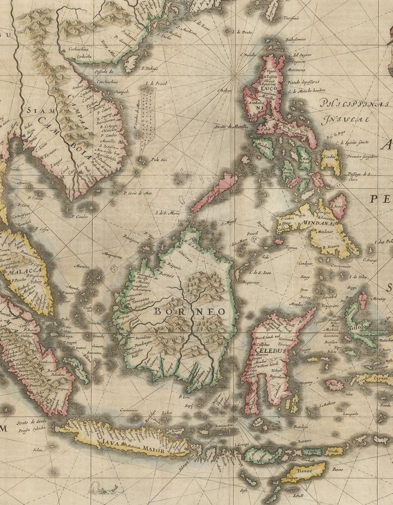
The Dutch, however, were by no means lagging behind when it came to exploration of the South East. Although preceded by the Portuguese and Spanish, whose presence in the region is captured by the 1622 ‘Descripcion’ of Antonio Herrera (items 62, 64, 65) and Claesz’s ‘Itinerario’ of 1596 (items 26-30), the VOC (Vereenigde Oostindische Compagnie, or Dutch East India Company) soon made its presence known in the East Indies, establishing many bases on the northern coast of Java during the early decades of the seventeenth century. They Dutch voyages that departed from
Java did much to develop the European understanding of the Pacific and Indian Oceans, as well as the western two thirds of continental Australia, which they named “New Holland”.
Among these expeditions was that of the Duyfken in 1606 which, despite its failure to find the desired route to Peru, made an arguably more important discovery: its captain, Willem Jansz, was the first recorded European to see and map the coastline of Australia. Such early Dutch discoveries were recorded in earnest by the mapmakers of Amsterdam, which was then the centre of cartography, including Janssonius, whose 1633 map of the East Indies (item 39) shows Cape York identified as “Duyfken’s Eylant”.
The western limits of Australia soon came to be defined by a series of navigational errors, including the accidental landing at Shark Bay, at what is now Dirk Hartog Island, by the Eendracht in 1616 after the ship was separated from the rest of the fleet heading from the Netherlands to the Dutch East Indies. The same mistake was repeated by a number of VOC Merchantmen; some were shipwrecked on the treacherous coast, but those who survived provided new and valuable information that allowed cartographers and navigators to join the dots to outline part of the western coastline.
In 1622, an English ship, the Tryall, was wrecked on what came to be known as the Tryal Rocks, off the Montebellow Islands (item 80). This stimulated an immediate response from the Dutch - not out of any concern for the lives of the English sailors, but because of perceived threat to their monopoly on New Holland’s potential resources. Thus in 1623 Jan Carstensz (item 55) was commissioned to re-trace the route of the Duyfken in order to make an economic appraisal of the land. Carstensz achieved little in his ship, the Pera, other than extending the length of the known coastline, while his compatriot Willem Colster, sailing in the Arnhem, crossed the Gulf of Carpentaria, then sailed north along the east coast of Arnhem Land (item 40).
Perhaps best-known of the seventeenth century Dutch voyages were those of Abel Tasman in 1642 and 1644 (items 45-52). These foundational events in the histo-cartography of Australia provided a database of geographical and hydrographical knowledge utilised by around 20 Dutch mapmakers during the second half of the century. The first voyage sailed south of the southern coast, discovering Tasmania and New Zealand, before circumnavigating continental Australia. Tasman named the west coast of New Zealand “Staten Landt”, thinking it to be the western extension of the Great Southland described in the memorials of de Queiros (item 63), and Tasmania “Van Diemen’s Land” after the VOC Governor in Batavia who had commissioned his expedition. Along the way he also discovered the island groups of Samoa and Fiji. His second voyage across the north further joined the dots of earlier Dutch discoveries, completing a reasonable sketch of the western two thirds of the Australian continent.
Around this time, Dutch dominance in cartography was complemented by the state’s independent and powerful emergence from both the Thirty Year War and the War of Dutch Independence, both of which concluded in 1648. The extent of the Dutch contribution to the discovery and mapping of terra australis is well represented by comparing the world maps of Willem Blaeu in 1606 and his son Joan in 1662. The early Blaeu map was initially sold as a separate sheet, but then included in his atlas “Nova Terrarum Orbis” between 1630 and 1658, while the latter was the signature map in the “Atlas Maior” between 1662 and 1672. In this later world map, gone was the hypothetical southern land mass of Mercator, replaced by continental Australia, lacking only an eastern coast, and empty seas.
The Dutch hegemony over Southern Hemisphere discovery, which was motivated primarily by trade, was eventually unseated by a wave of scientific zeal during the Age of Enlightenment and the long eighteenth century (item 114). In 1768, the British Admiralty commissioned James Cook to command a scientific voyage to the Pacific, in order to record the transit of Venus across the Sun, with the ultimate purpose of determining the distance between the Earth and Sun. After mapping the complete coastline of New Zealand, with only minor errors, the HMS Endeavour sailed on to Australia, becoming the first recorded European expedition to encounter the continent’s eastern coastline in 1770. The voyage also included a week-long stay at Botany Bay, so named for the unique botanical specimens collected there by Joseph Banks and Daniel Solander.
Despite having charted almost the entire eastern coastline of Australia, and demonstrated its continental size, Cook’s contemporaries still insisted that there should exist another separate and massive southern continent, the true terra australis. Prominent among these was Alexander Dalrymple, who, as Examiner of Sea Journals for the English East India Company, had translated de Torres’s testimony concerning the northern coast of this unknown land. Dalrymple was thus inspired to publish the “Historical Collection of the Several Voyages and Discoveries in the South Pacific Ocean” in 1770–1771 (item 79), which prompted the British government to order Cook on a second expedition.
No landfall was achieved on Australia during this second expedition, which nonetheless contributed greatly to British knowledge of the southern hemisphere (item 113). During the expedition, Cook became the first recorded navigator to cross the Antarctic Circle, although he did not encounter the Antarctic mainland itself.
Decades later, discovery and exploration of the Antarctic would finally conclude the pursuit of the terra australis incognita that had spanned centuries. Nonetheless it was the great landmass uncovered gradually during the intrepid explorations of the sixteenth, seventeenth and eighteenth centuries that took its name from the cartographical legend, when in 1824 the Admiralty agreed that the land should be known officially as Australia.
Robert Clancy