Outdoors for Everyone
Environmental Education and Access in Pittsfield
Prepared for Berkshire Natural Resources Council
The Conway School Winter 2026
Millie Manning - Sophie Phelan - Kenny White

Prepared for Berkshire Natural Resources Council
Prepared for Berkshire Natural Resources Council
The Conway team would like to express our appreciation for the people who helped support this project, especially:
Charlotte Hood, Emily Daunis, and Taylor Staubach at Berkshire Natural Resources Council
James McGrath, City of Pittsfield
Seth Jenkins, Berkshire Regional Planning Council
The Conway School Faculty & Staff
Land Acknowledgement, courtesy of BNRC & the Stockbridge-Munsee Mohican Nation
All of the present-day Berkshires are the ancestral homeland of the Mohican people, who were forcibly displaced to Wisconsin by European colonization. These lands continue to be of great significance to the Stockbridge-Munsee Mohican Nation today. To learn more, visit mohican.com.
Berkshire Natural Resources Council (BNRC) asked a team of graduate students from the Conway School to assess how environmental education could be made more accessible to underserved populations in Pittsfield, Massachusetts. Pittsfield is the most populous city in Berkshire County, with a poverty rate nearly fifty percent above the state average and a landscape marked by decades of industrial contamination from General Electric's use of polychlorinated biphenyls (PCBs) in transformer manufacturing. Contamination sites are concentrated disproportionately in or near Environmental Justice (EJ) populations. An EPA-approved remediation plan for the Housatonic River will bring substantial cleanup activity to Pittsfield beginning in 2027.
The Conway team inventoried the city's open space, environmental education programming, and community organizations, and conducted engagement with residents and local organizations. The key spatial aspect of this project is that the city's largest and most ecologically rich open spaces are on the periphery, while its most underserved populations live near the city center. The open spaces walkable from the highest density EJ populations are mostly small city parks with limited or no environmental education programming. Two census tracts in the city center have notably low vehicle access (28 and 36 percent of households without a vehicle, respectively), reinforcing the case for programming within walking distance. Community organizations identified transportation as a near-universal barrier for the populations they serve. Residents reported that they often do not know what programming is available.
Pittsfield has a broad and active network of organizations providing environmental education, and BNRC already partners with many of them. However, much of the existing programming assumes a level of access that the most underserved populations may not have.
The report's recommendations are grouped into operational and spatial scenarios. Operational scenarios include coordinating environmental education with the upcoming Housatonic River remediation, establishing a regular physical presence in Pittsfield to build relationships with residents, convening a periodic forum of community organizations to reduce information silos, supporting existing partner organizations through funding and logistical assistance, and aligning future programming with Massachusetts science curriculum standards to facilitate partnerships with Pittsfield schools.
Spatial scenarios focus on locations where programming could most effectively reach underserved populations. The report proposes that BNRC supports community-led programming at Westside Riverway Park in partnership with Westside Legends, develops a series of urban ecology walks originating in the city center, and explores acquisition of a vacant lot in a high-density environmental justice population for conversion to a community garden. The report also identifies BNRC's Dubow Reserve and the George L. Darey Wildlife Management Area as sites where education about rare natural communities and biodiversity could complement the more urbanfocused recommendations.
The engagement conducted for this report reached approximately seventy residents, which is a small sample of Pittsfield. The recommendations draw on spatial analysis, an inventory of existing programming and organizations, and limited community input. They are intended as a starting point for BNRC's continued engagement with Pittsfield, not as a final determination of community needs.
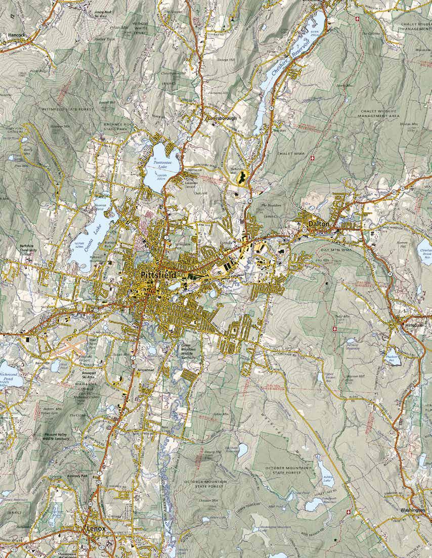
Berkshire Natural Resources Council (BNRC) is a land trust that has served as a steward of the natural landscapes of Berkshire County since 1967. Its mission is “conserving and caring for Berkshire lands, waters, and wildlife, and connecting people with nature for a more vibrant, shared future.” Across the county, BNRC actively cares for over 26,000 acres and more than sixty miles of trails that are free and open to the public. In Pittsfield, BNRC owns 702 acres of conserved land and holds the conservation restriction for another 112 acres.
BNRC commissioned this project to inform its efforts to bring environmental education to more underserved populations. BNRC narrowed the project focus to Pittsfield, the most populous city in the
Berkshires and the lowest in per-capita income. Additionally, BNRC identified an appetite for such programming in Pittsfield: a community engagement survey conducted in 2024 by the Pittsfield Parks and Recreation Department for the Open Space and Recreation Plan update found that nature programming was the most-requested addition to Pittsfield’s recreational offerings. In order to understand the community’s needs and what is already being done to address them, a team of graduate students from the Conway School conducted an inventory and analysis of the open space and the environmental education available within Pittsfield. The Conway team then developed recommendations for how to address observed gaps in access to environmental education.
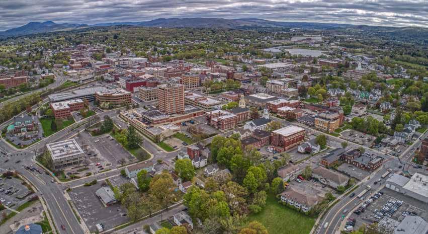
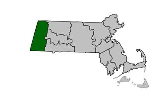
Pittsfield is the largest city in Berkshire County, located in the westernmost region of Massachusetts near the borders of New York and Vermont.
Positioned in the heart of the Berkshire Mountains, the city sits within the Housatonic River Watershed.
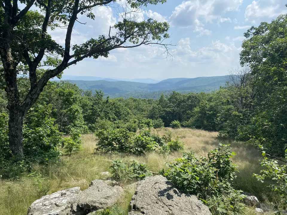
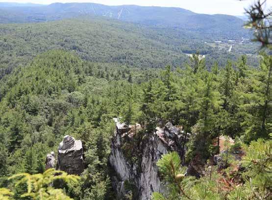
Berkshire County is characterized by a rich and varied ecological landscape, with extensive forests, agricultural valleys, and waterways that support biodiversity and recreation.
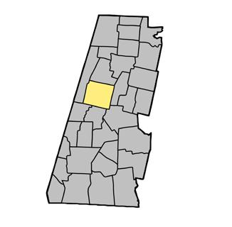
Within this broader context, BNRC has identified Pittsfield as a priority area for engagement. Pittsfield serves as a cultural and economic hub for Berkshire County, while also facing many of the challenges common to post-industrial cities including economic transition and environmental degradation.
Pittsfield residents may face comparatively limited access to open space and fewer opportunities for environmental education. Additionally, access to the region’s broader network of outdoor spaces may be uneven, with barriers such as transportation, awareness, and financial resources. Understanding and addressing these barriers is a key component of expanding equitable access to the ecological assets that define the Berkshires.
The city of Pittsfield sits on the ancestral lands of the Mohican, an Indigenous people whose territory historically extended throughout the Hudson and Housatonic River valleys. In the eighteenth century, colonial expansion and land speculation caused the displacement of Mohican Peoples from western Massachusetts. Many Mohican families joined the Stockbridge Indian community before being forced to relocate multiple times through the eighteenth and nineteenth centuries. After successive removals to New York and Indiana, the community ultimately settled in present-day Wisconsin, where the Stockbridge-Munsee Tribe remains today.
The displacement of Indigenous peoples from the region represents a major transformation of land stewardship in the Pittsfield area, replacing Indigenous land relationships with settler land ownership and development.
Following European settlement in the mid-eighteenth century, Pittsfield developed primarily as an agricultural town supported by mills producing lumber, paper, textiles, and grain. By the early nineteenth century, the introduction of Merino sheep transformed Pittsfield into a major center of wool production in the United States.
These industries relied heavily on the region’s waterways, particularly the Housatonic River, which powered mills and supported manufacturing activities. This period marked the beginning of a long relationship between Pittsfield’s economy and its waterways, setting the stage for later industrial development along the river corridor.
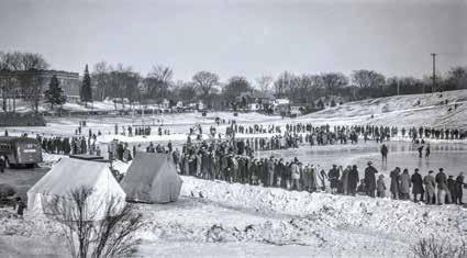
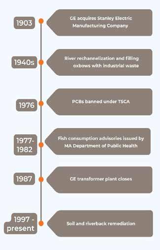
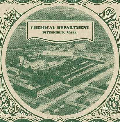
Pittsfield’s industrial landscape changed dramatically in the early twentieth century when the General Electric Company (GE) established a major manufacturing presence in the city.
Polychlorinated Biphenyls (PCBs) are a group of synthetic chemicals that were widely used in electrical equipment due to their insulating and fire-resistant properties (“General Electric and PCBs”). GE used large quantities of PCBs in transformer manufacturing in Pittsfield until the chemicals were banned in the United States in 1976 under the Toxic Substances Control Act (TSCA).
During decades of manufacturing activity, materials containing PCBs were released into the environment through improper disposal, dispersal throughout the city, and industrial waste practices. These chemicals entered soils, groundwater, and the Housatonic River. Because PCBs do not easily break down and can travel through air and water, contamination spread beyond the GE plant site into residential areas and river ecosystems.
“We used to use an average of 20,000 gallons of Pyranol a week and this is if you do simple mathematics, this is one hundred and forty thousand pounds of … PCBs a week that we were handling. And we had a loss rate: spillage, overfilling, of about 3% so this says that every week we would lose between four and five thousand pounds of PCBs that would go down into the drain and into the river. …About a million and a half pounds of PCBs have been plowed into that river. I imagine a good 30% is left.”
Quotation from the Housatonic River Initiative’s website, quoting Ed Bates, the former Manager of Tests at the Power Transformer Division at GE
In some locations, contamination has resulted in Activity and Use Limitation (AULs), which restrict certain types of land use to protect public health (Mass.gov). These restrictions continue to influence how land in Pittsfield can be used, including for recreation, ecological restoration, and environmental education.
Following the decline of GE’s presence in Pittsfield, the city has faced ongoing economic and physical redevelopment challenges, prompting a shift toward strategic reinvestment and planning (Pittsfield Master Plan, 2009). Investment moved away from the historic downtown and toward more auto-oriented development including plazas and strip malls along the eastern corridor of the city. This pattern contributed to disinvestment in the urban core. In recent decades, there has been a renewed focus on revitalizing downtown Pittsfield, with efforts aimed at reinforcing its walkable, mixed-use character and reestablishing it as a center of economic and cultural activity in Berkshire County.
The history of contamination and cleanup has increased local awareness of environmental health and river stewardship. Revitalization projects are reviewing interest and quality of life downtown. This presents opportunities for environmental education programs, especially in the urban core, that help residents to understand the history of the Housatonic River, ongoing restoration efforts, and the relationship between industrial activity and environmental health.
The city’s landscape reflects layers of Indigenous stewardship, industrial development, environmental contamination, and ongoing restoration. Each of these offer opportunities for place-based learning and engagement.
Pittsfield’s landscape and population have been heavily influenced by the presence and eventual departure of General Electric. Pittsfield’s population saw major growth between 1900 until it peaked around 1960-1970 when it reached 58,000 residents (“Pittsfield, Massachusetts Population 2024”). Pittsfield’s population declined following GE’s closure of their power transformer division in 1987, affecting thousands of jobs.
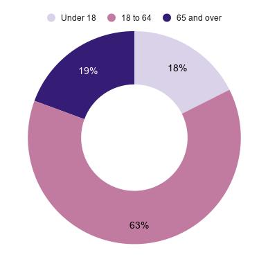
According to Census Reporter, as of the 2024 census, the total population is around 43,100 residents. The city’s age distribution skews slightly older than the state average, with a median age of 43.2 and almost 30% of residents over 60, indicating a significant older adult population. This distribution has important implications for environmental programming, suggesting a need to balance youth-oriented education with intergenerational activities.
Economic indicators further highlight disparities within the city: 14.9% of residents live below the poverty line, which is higher than in both Berkshire County and Massachusetts. Low-income populations may face barriers to access to transportation, recreation, and environmental engagement.
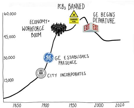
Population trend graph with notable historical milestones.
Westside Neighborhood
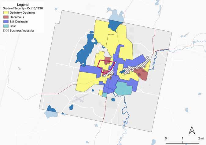
Present-day patterns of demographic distribution are shaped in part by historic disinvestment, including redlining practices (“Mapping Inequality”). This map shows areas of Pittsfield used by mortgage lenders in the 1930s, prior to widespread public awareness of the environmental contamination associated with GE’s operations. Patterns of disinvestment were driven by social and economic discrimination rather than by environmental risk at the time. Neighborhoods that were historically graded as “hazardous” (red) or “declining” (yellow) often correspond to areas with lower incomes and higher
concentrations of Environmental Justice populations today.
In Pittsfield, the Westside neighborhood in particular was largely classified with these lowest grades, a designation that has had lasting impacts on access to homeownership, investment, and generational wealth accumulation. Understanding these overlapping spatial and historical inequities provides important context for prioritizing equitable access to open space and intentional environmental education initiatives.
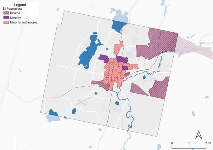
BNRC has identified Environmental Justice (EJ) populations as a priority audience for future environmental education. The concept of EJ populations emerged from the environmental justice movement of the 1980s, when studies documented how industrial facilities were disproportionately located in lowincome communities and communities of color, and protests raised awareness about these issues (Sierra Club). As a result, these populations often faced higher exposure to environmental contaminants.
In Massachusetts, EJ populations are identified using demographic indicators established by the Massachusetts Executive Office of Energy and Environmental Affairs. Within Pittsfield, EJ designation is based on census block groups that meet thresholds related to household income or minority population (Mass.gov). While these designations function as demographic indicators rather than direct measures of lived experience, they provide a useful proxy for identifying populations that may face disproportionate environmental burdens.
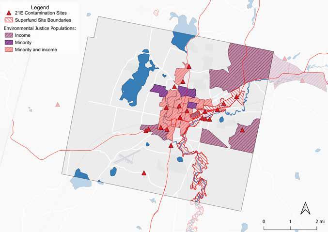
Chapter 21E is the Massachusetts Oil and Hazardous Material Release Prevention Act, which encompasses “issues related to the identification and cleanup of property contaminated by releases of oil and/or hazardous material to the environment” (Mass.gov). At the federal level, the Comprehensive Environmental Response, Compensation, and Liability Act (CERCLA), commonly referred to as the “Superfund,” established a program for identifying and remediating the nation’s most hazardous waste sites. This map shows both state-listed Chapter 21E sites and federally designated Superfund sites across Pittsfield.
Spatial analysis reveals a clear pattern: contamination sites in Pittsfield are disproportionately concentrated within or adjacent to EJ populations. This suggests a strong geographic correlation between environmental burden and vulnerable populations. This overlap has important implications. First, it raises concerns about disproportionate exposure to
environmental health risks. Second, this pattern complicates efforts to expand environmental education and outdoor programming in these neighborhoods. Open spaces may be constrained by contamination history or lingering public perception of risk. Without clear communication, remediation, and in some cases physical redesign, these sites may remain underused despite being located in areas with high demand for accessible open space.
Thoughtful remediation, transparent interpretation, and community-engaged design can transform formerly contaminated sites into spaces for environmental learning. Making the history of contamination visible, while also highlighting processes of cleanup and ecological recovery, can support place-based education and foster greater environmental awareness. This dynamic is particularly relevant for sites such as Westside Riverway Park, featured on page 51, where past industrial use and contamination shape both current conditions and future possibilities.
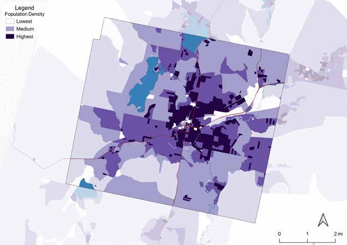
Compared to surrounding rural towns, Pittsfield has higher population density and a greater concentration of commercial development and transportation infrastructure. Highest density areas are mostly located toward the center of the city, with a gradient out to the city limits.
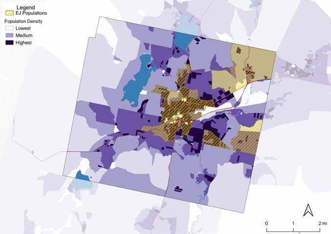
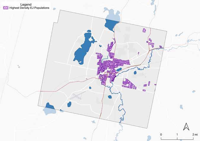
Overlaying population density layers with EJ census blocks shows that several EJ census block groups
are concentrated in and around downtown Pittsfield (opposite page, top). The physical proximity of residents to programming may correlate with likely attendance. This analysis helps identify the locations where environmental education programming could reach the greatest number of residents who are most likely to face environmental inequities (opposite page, bottom).
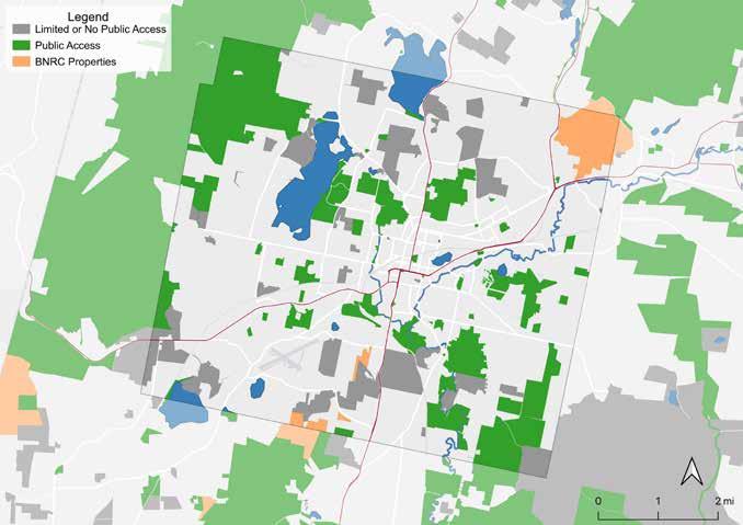
In this document, the term “Open Space” includes conservation and outdoor recreational facilities owned by federal, state, county, municipal, and nonprofit entities. It includes parks, wetlands, forests, agricultural land, and recreation areas. Some open space is protected in perpetuity, while some has limited or no protection. 5,965 acres, or 22% of Pittsfield’s land is permanently protected.
This map includes open space with no or limited public access for context. All subsequent maps will
show publicly accessible open space only.
BNRC’s Pittsfield properties, highlighted in orange above, are Mahanna Cobble, the Boulders, and the Dubow Reserve. Mahanna Cobble and the Boulders straddle the southern and northern city limits respectively. They feature signage and marked trails, as well as parking lots. Dubow Reserve is the closest to the underserved populations in the center of town, but it is not identifiable nor easily accessible from the road.
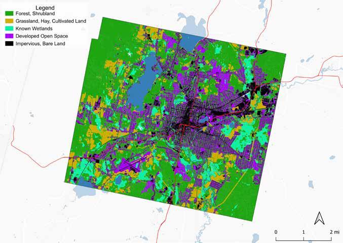
This map shows the MassGIS land cover data collected in 2016, categorized into five types. Organized by the theoretical quality of experience each category offers human visitors, this map shows that impervious and “developed open space” dominates the center of Pittsfield. “Developed open space” in this context refers to mostly managed
grasses or low-lying vegetation, such as that found in airports, golf courses, and neighborhoods. More natural land covers are generally located toward the periphery of the city, with a notable exception being wetlands. Wetlands are more evenly distributed throughout Pittsfield.
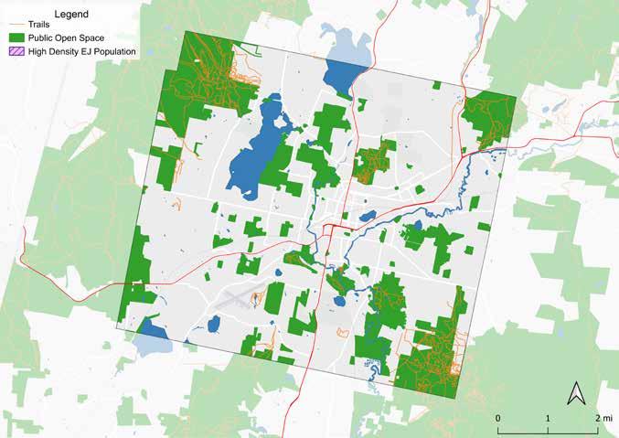
According to survey data taken for the City of Pittsfield’s upcoming 2026 OSRP, hiking/walking was the second-most popular activity for respondents, closely following gardening. Over 85% said they hike or walk outdoors at least once per month.
The distribution of trails underscores the pattern of larger contiguous parcels of open space being con-
centrated towards the periphery of Pittsfield. Springside Park and Fred Garner Park are the only parks that contain trails inventoried by Berkshire Regional Planning Commission (BRPC) that are within or adjacent to the high density EJ populations in the city center.
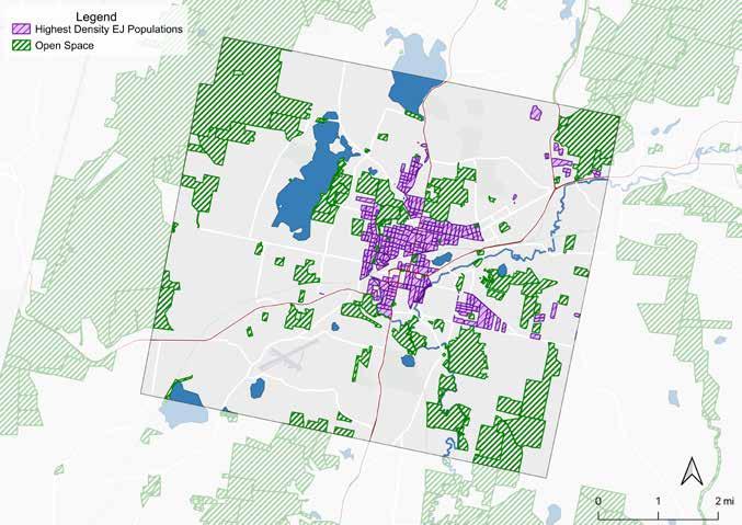
To identify opportunities for expanding environmental education in Pittsfield, it is important to understand how Environmental Justice populations are distributed relative to the city’s open spaces. The largest contiguous open spaces are generally located toward the outskirts of the city limits, while the highest density EJ populations are concentrated in more central neighborhoods.
This spatial pattern can create barriers to accessing environmental education programming if it is limited to those larger, more “natural” spaces, particularly for residents who rely on walking or public transportation. The open spaces closer to EJ populations tend to be smaller city-owned parcels like parks, which may be well-suited to more urban ecology education.
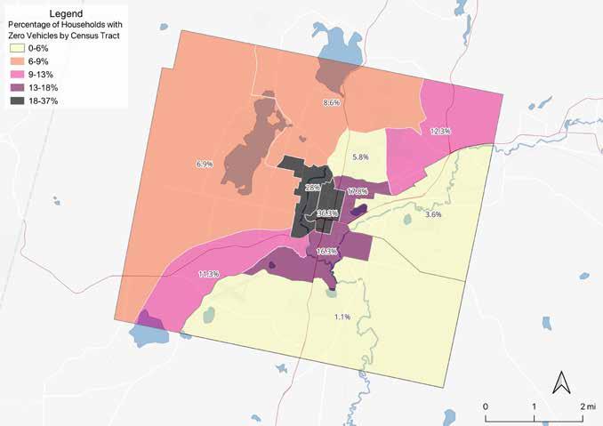
This map shows the percentage of households with zero vehicles; a lower percentage indicates higher rates of ownership of vehicles and a higher percentage indicates lower rates of ownership of vehicles. The distribution of higher percentages is mostly cen-
trally located, with two census tracts having significantly lower access to vehicles (28% and 36.3%). This indicates that residents living toward the center of Pittsfield may rely on public transportation, biking, or walking.
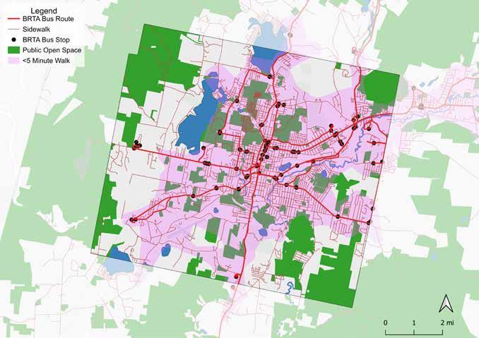
This map layers open space, BRTA bus routes, bus stops, and an isochrone layer which depicts the area accessible from a point within a certain time threshold. The isochrone layer (in pink) was created using Openrouteservice.org’s data to estimate areas within a five-minute walk from bus stops. Most of Pittsfield, including its residential areas, is within a short walk to a bus, and there are numerous publicly available
open spaces within a five-minute walking distance to public transportation. However, it is important to acknowledge that there are any number of other reasons that someone reliant on public transit may choose not to use it to access open space, such as a limited bus schedule, unreliability, and safety concerns.
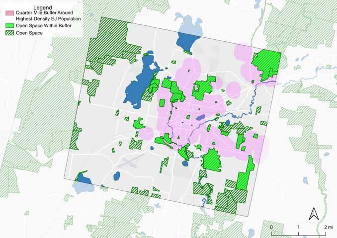
To better understand which spaces do not require a vehicle to be accessed by EJ populations, a walkability buffer was created around the census blocks with the highest density of EJ residents. This buffer represents one quarter mile. This map highlights the open spaces that fall within this walkable distance, which may be especially well-positioned to support environmental education for this population.
These spaces are inventoried on page 26, and include public schools, city-maintained parks, cem-
eteries, sports fields, skate parks, playgrounds, conservation and wildlife management areas, and the public common. This diversity of spaces could support a number of different types of nature programming.
The buffer on this map is determined only by distance, and does not take into account other aspects of walkability, such as sidewalk quality, shade, slopes, and pedestrian crossings.
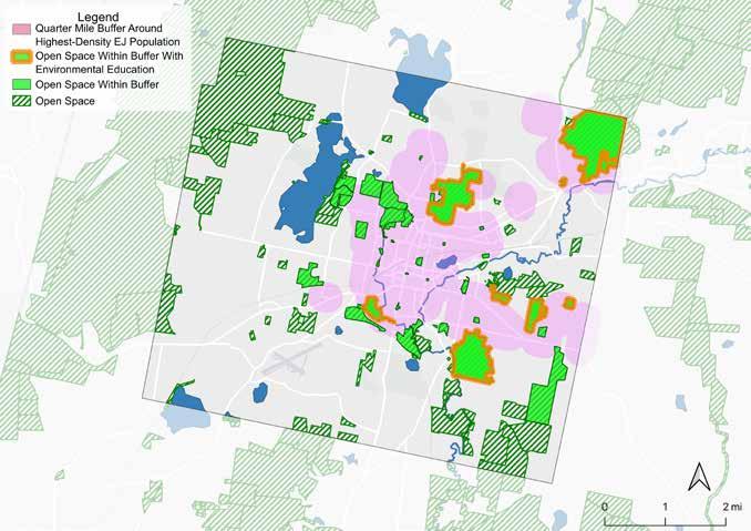
This map highlights open spaces within the walkability buffer where environmental education activities, including guided hikes, tree identification walks, and community gardening, are currently known to occur. These locations represent potential opportunities to expand programming or partnerships.
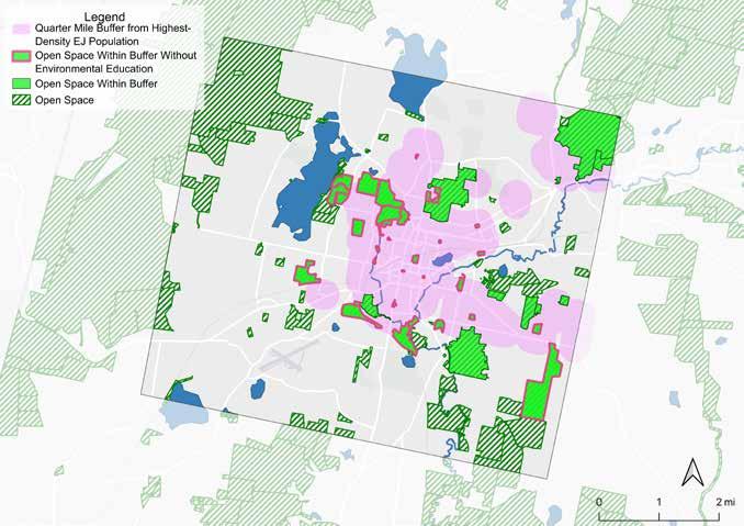
Several open spaces within the walkability buffer do not appear to currently host environmental education programming. These locations represent potential opportunities to establish new programming, interpretive signage, guided walks, or community partnerships.
This map highlights these sites as priority areas where environmental education could be developed
in order to increase equitable access to environmental learning opportunities across Pittsfield. Prioritizing education initiatives in these locations could help bring nature-based learning opportunities closer to communities that may otherwise face barriers to accessing the city’s larger conservation areas.
The table below includes the open spaces that fall within the quarter mile walkability buffer from high-density EJ populations, mapped on the previous pages. The owner or manager are listed, alongside level of protection and acreage. Finally, the spaces are sorted based on whether there is known educational programming hosted in each space.
Boulders WCE
Brattle Brook Park
Canoe Meadows Wildlife Sanctuary
Clapp Park
Coolidge Park
Crane Playground
Egremont School
Herberg Middle School
Reid Middle School
Wahconah Park
Williams School
Crow
Westside Riverway Park
Belanger Youth Athletic Facility
of Pittsfield
BNRC’s primary organizational focus is land conservation, both through direct acquisition and through partnerships with individual landowners, local land trusts, regional conservation partners, and state agencies. Ease of access to the outdoors and welcoming a variety of outdoor enthusiasts are important to BNRC, and all of BNRC’s reserves are free and open to the public.
BNRC facilitates some environmental education already, both through events and materials. According to BNRC, events are mostly guided hikes, often in partnership with other organizations such as OLLI, the adult learning extension of Berkshire Community College, or Latinas 413, which offers Spanish language guidance. Guided hikes sometimes have a particular educational focus, such as animal tracks in snow, or plant identification, while some do not.
BNRC provided the Berkshire Athenaeum with hiking backpacks for its Library of Things, so that families can check out a backpack with helpful hiking items including a pocket guide, rain ponchos, first aid kit, binoculars, magnifying glass, bug spray, and a compass (“Pittsfield Library of Things: Outdoor Recreation”).
Otherwise, BNRC does not have an extensive history of environmental education programming or onstaff educators. BNRC has shared that it is open to offering programming to any audience in Pittsfield, but would like to focus on topics and activities that have been requested by the community. A wide variety of community organizations host environmental education and are connected to Pittsfield residents, which are detailed in the Community Organization Inventory section on pages 35-38.
Environmental education is defined by the EPA as a process that allows individuals to explore environmental issues, engage in problem solving, and take action to improve the environment (United States Environmental Protection Agency). Environmental education programming can be targeted to all age groups and experience levels, and can be located in any number of spaces. Because the definition of environmental education is so broad, this report uses two spectrums to describe different education experiences in terms of how and where people engage with programming.
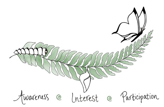
The decision journey is a commonly used concept within marketing and sales organizations. It follows a person from awareness of a option, through familiarity and consideration, to action (Court et al, 2009). While BNRC’s intent is not to sell a product, this lens can be used to encourage engagement with environmental education. When applying this decision journey to environmental education, there are similar stages of engagement: awareness of an environmental topic or programming (e.g., through seeing signs in parks or community gardens), being inter-
ested in the topic or program (e.g., talking about it with other residents), and actively participating (e.g., signing up for park cleanups, or volunteering at the community garden). Offering programming to people at all stages of engagement is one strategy to meet people where they are, psychologically.
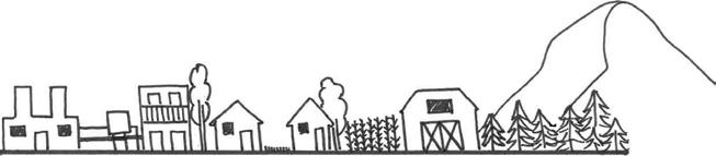
Pittsfield contains a wide variety of outdoor spaces, from contaminated lands, to the dense residential core of Pittsfield, to the more “natural” feeling reserves on the outer edges of town. Broadly, one can find examples of environmental education in all of these places (e.g., urban ecology walks, bird-
watching in the suburbs, education on farms, and wilderness survival classes). Offering programming in spaces at all levels of perceived naturalness is one strategy to meet people where they are, physically.
The graphic below can serve as a tool for identifying where a particular program falls on both spectrums. There is not a “best” location or level of engagement when it comes to programming or audience. Rather, this visualization allows the reader to see the diversity of options for programs. The assumption here is that having programming in all areas represented in the graphic is a more equitable way to expand environmental education to more people. In Pittsfield, some residents have more access to programming
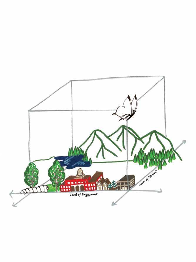
outside of the walkable center of town, due to vehicle or financial resources. There may be more programs targeted to certain age groups or topics of interest. Depending on BNRC’s organizational priorities, it could choose to focus its efforts based on desires identified through the community engagement process, gaps identified via an inventory of the existing environmental education in the area, and/or spatial analysis of gaps in access. The following sections explore each of these directions.
Community engagement was structured to gather information both from Pittsfield residents and from community organizations already offering nature programming in Pittsfield.
The Conway team hosted a two-hour tabling session at the Berkshire Athenaeum, Pittsfield’s public library, on February 14, 2026. The open session included:
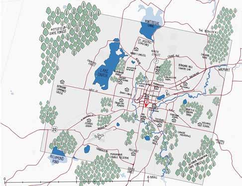
• A map for people to mark the neighborhoods where they live, and their favorite outdoor spaces in Pittsfield
• An easel flip chart to answer the question “What do you like to do outside?”
• Brochures from BNRC
• A digital survey to complete, either in-person on an iPad, or via a QR code to take home
• An invitation to discuss with the Conway team environmental issues, nature programs, and outdoor spaces
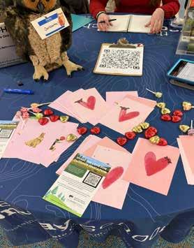
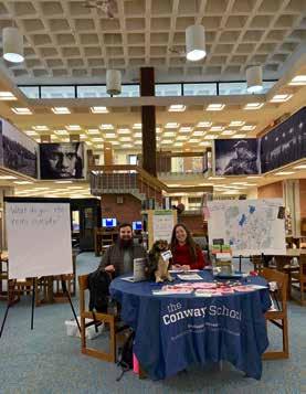
The Conway team conversed with ten Pittsfield residents, of varying ages and backgrounds. Sentiments shared by residents included (paraphrased):
• There is a membership organization of business and non-profits, Downtown Pittsfield Inc., that often removes foragable plants that some community members have come to love and rely on, in favor of planting “more ecological” plants.
• “It’s not like we live in a concrete jungle!” implying that a conversation about outdoor space and nature programming was unnecessary.
• Stop the GE cleanup of the Housatonic, and let nature take its course–even if it takes hundreds of years.
• The Boulders is a nice walk from the public housing located in the northeast of town.
• “I’m not a tree hugger!” - a man who went on to describe his love of eagles.
Many individuals contradicted the feedback of other residents, such as wanting more spaces for dogs while others wanted dogs banned from certain spaces. There was also some general confusion, where people were not sure what the team meant by “nature programming,” or talked about outdoor experiences from their childhood growing up in other places.
The residents’ comments suggest a varying degree of ecological literacy–the forager referenced above had a deep and detailed knowledge of the spaces in Pittsfield that would be an environmental education topic unto itself, while others showed indifference to open spaces in Pittsfield, or a simple appreciation for open spaces walkable from housing.
Broadly, feedback shows how individuals’ perception of environmental education encompasses a variety of topics—foraging, environmental degradation, urban ecology, and wildlife.
The City of Pittsfield is in the process of updating the City’s Open Space and Recreation Plan from 2014, and is required to have several public meetings to gather residents’ feedback and share updates. The Conway team was invited to participate in a public OSRP meeting on the evening of March 5, 2026.
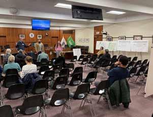
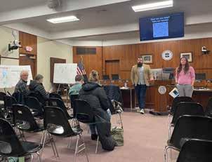
The Conway team and BNRC gave a ten-minute presentation, then asked the series of questions below, which the participants were able to respond to live via Mentimeter, an interactive presentation accessible on their phones. The City also provided tablets for anyone without a smart phone.
Some responses to the question, “What nature programs do you already participate in?”:
• Guided nature walks with BNRC
• Pittsfield Community Garden program
• BEAT river cleanups and invasive plant removal
• Native plantings in downtown Pittsfield
• Hoffman Bird Club
• None
Some responses to the question, “What barriers prevent you from participating?”:
• Difficulty finding offerings and events on the City website
• Lack of reliable and safe bike paths to get places
• Financial
• Time constraints
Some responses to the question, “What types of programming would you like to see more of?”:
• Walking botany inventory and tours
• Education about the Housatonic River cleanup, restoration, and future protection
• Volunteer cleanup opportunities for the Housatonic River
• Garden courses in community gardens
• Summer workforce training in trail construction
• Removal of invasive plant species and overgrowth
• Guerilla gardening to combat heat island effects
The online resident survey was promoted at the OSRP meeting, at the Berkshire Athenaeum tabling session, and on BNRC social media. The survey was open from February 14, 2026, through March 9, 2026. The most responses came in after a BNRC social media post, indicating that most engagement was from people already in BNRC’s audience. There were a total of 36 respondents, which is a very small sample size for Pittsfield. That said, there were some noteworthy patterns among responses.
Half of respondents to the survey were above 60 years old, whereas the median age of Pittsfield is 43. This could indicate that the audience BNRC typically engages with is on the older side. However, 27% of respondents had children under 18 in their household, which is consistent with Pittsfield demographics. The largest neighborhood representation was Westside, with 25% of the respondents. This is promising, as BNRC had hoped to engage with the Westside neighborhood specifically.
Nearly half of respondents reported no barriers to participating in activities. The most frequent reported barriers were “Don’t know what’s available” (37%) and “No programs near me or at convenient times” (14%).
52% of respondents participated in nature programming in the past year. The most frequent activities were hiking/walking and volunteer cleanups. The organizations with the highest participation were BNRC (53%), followed by Mass Audubon (50%) and BEAT (37%).
When asked what nature programming respondents would like to see, the most frequent responses were Adult outdoor skills workshop (60%), Volunteer opportunities (57%), Evening or weekend programming (48%), and Familyfriendly hikes (45%).
57% of respondents heard about events through word-of-mouth, followed by flyers in the community (48%), email newsletters (42%), and Facebook (40%).
Full survey results are in the Appendix. BNRC may run the survey again in the future.
All modes of resident outreach resulted in a relatively low number of responses. There were 66 residents engaged in the outreach process, which is 0.14% of the Pittsfield population. Further engagement would provide more insight into the needs and desires of the general population. Themes from all forms of resident engagement include:
• Knowledge of events and marketing was a reported gap, validated by the low number of responses generally. Residents identify a need to improve event visibility on existing channels that people already use (flyers, email newsletters, city and affiliated websites), and to promote across organizations.
• Adult skills workshops outside of typical working hours would be the most in-demand activities. With respondents also looking for volunteer opportunities, there could be a synergy if any local Pittsfield residents have outdoor expertise to share.
• The Housatonic cleanup continues to be a source of interest and concern for community members. Residents seek education about why the cleanup is necessary, what it entails, and whether residents can get involved.
• Residents are interested in a wide range of programming. Foraging, native plant communities, volunteering, community gardens, and urban challenges such as heat island mitigation were all suggested. Fostering a diverse array of nature programming would be beneficial for ongoing engagement in Pittsfield.
Community Organization Survey
The Conway team also conducted outreach to local community organizations who already have an engaged audience in Pittsfield, including historically underserved communities. Details on programming are in the following Community Organization Inventory section, but the survey results also revealed patterns about Pittsfield community members. Some highlights from the eight community organizations who responded:
62% of organization respondents serve Pittsfield in its entirety, followed by organizations that said they served residents in the Westside (50%) and Morningside (37%) neighborhoods specifically.
87% of organization respondents indicated that transportation was a barrier for their population served, followed by lack of information (75%) and financial limitations (75%).
All responding organizations prioritize serving one or more of the following communities: individuals with disabilities, non-English speakers, LGBTQ+, BIPOC, low-income, and Environmental Justice.
Some of the responses are the same as those shared by residents, like a desire for more information about programming. Some of the responses differ, like concern about transportation and financial limitations, likely because there are different audiences. These community organizations were founded to serve marginalized communities, and BNRC may weigh their feedback more heavily when making decisions in order to prioritize those populations.
There are a wide range of community organizations in and near Pittsfield, providing environmental education, recreational activities, family and community support, and advocacy. Some of these provide environmental education already, and some do not; some but not all are already BNRC partners.
Each organization falls into one of the following categories:
• BNRC partners that provide environmental education in Pittsfield
• BNRC partners that provide environmental education, not yet in Pittsfield
• BNRC partners in Pittsfield, that do not provide environmental education
• Non-partners that provide environmental education in Pittsfield
The following inventory is not a comprehensive list and also reflects a snapshot in time–some organizations may have fluctuating activities in Pittsfield due to seasonality, resource constraints, or other reasons, while BNRC partnership status may also change. The mission statements in the following tables are directly from the organizations’ websites. The appendix provides a list based on the current status, and a digital version allows for ongoing database maintenance by BNRC.
Organization
Berkshire Environmental Action Team (BEAT)
Mission
“BEAT envisions a world where all people recognize their interconnectedness to, and dependence on, the natural world; the air and water are clean; rivers and streams flow naturally; rain soaks into the ground and makes its way slowly to our lakes and rivers; there is plenty of interconnected, natural land where wildlife thrive; and communities work together to sustain their environmental health and economic vitality.”
Programming
Guided hikes, workshops, presentations, trainings, volunteer cleanups, and “Green Drinks” sessions that focus on different topics each month.
Partnership details provided by BNRC
Frequent partner (cohosts, cross-promotion).
Berkshire Community College (BCC) OLLI
“OLLI at BCC is a volunteer-driven, inclusive learning community of adults 50+ offering diverse educational programs, social interaction, and community engagement.”
seeing rainbows “seeing rainbows cultivates holistic liberating systems to build solidarity and care... we take direct action by producing and presenting liberating arts experiences by and for trans people and all other marginalized persons.”
Latinas 413 “Latinas 413 is dedicated to igniting the collective power of Latinas, expanding their social and economic capital, and serving as a bridge to the resources available in Berkshire County.”
Greenagers
“Greenagers works to inspire children and young adults to develop deep connections to land, work, and community. We prepare youth for success in work and life by offering paid jobs and education in the areas of conservation, sustainable farming, and related trades.”
Joint guided hikes with BNRC; semester-long classes on topics such as wildflowers, indigenous stewardship, and literary ecology.
Weekly trans hikes throughout the Berkshires, outside of the winter season.
Spanish-language outdoor programs that include activities like hiking, camping, kayaking, and biking.
Field trips for all ages to April Hill Conservation Center in South Egremont; one to three sessions in schools.
Frequent partner (cohosts, logo promotion).
Frequent partner (cohosts, some financial support, logo promotion).
Recently refreshed partnership including cohosting events.
Frequent partner in both Stewardship & Community Engagement.
Mixed Faces Wild Spaces
Flying Cloud
“We empower community members of intersectional lived experiences to reclaim belonging and connection with themselves, each other, and all of nature—through inclusive and trauma informed outdoor experiences that provide tools, education, and community.”
“The mission of Flying Cloud Institute is to inspire young people and educators through dynamic science and art experiences that ignite creativity.”
Workshops, retreats, and nature-based events, including foraging, queer ecology hikes, tracking, and shelter-building.
Programs in public schools on topics such as climate change, flood modeling, wind power, seasonal habits of wildlife, and geology.
Past partnership, currently paused.
Partnered on annual STEAM nights.
BNRC partners that provide environmental education outside of Pittsfield
Organization
Unpaved Trails For All
“Unpaved Trails For All started our advocacy in Northampton, Massachusetts simply trying to get the city to create an unpaved, universally accessible, all persons trail. Through those efforts we soon realized that the lack of accessible nature trails was a statewide problem… Having accessible trails at the local level can help to ensure that accessible nature spaces are never too far away.”
Black and Wild “Black&Wild is an educational platform dedicated to connecting Black, Indigenous, and People of Color with nature through mindful wilderness trips and ancestral skills.”
Unpaved Trails For All hosts nature walks on accessible trails, but not yet in Pittsfield. They advocate for and consult on accessible trail creation in all of MA.
provided by BNRC
Frequent partner and consultant on accessibility. Part of BNRC’s DEIAB (Diversity, Equity, Inclusion, Access, and Belonging) Committee.
Workshops on ancestral nature skills such as wilderness first aid, basket weaving, herbalism, and tracking.
Not a frequent partner, but BNRC did previously provide financial support.
BNRC partners in Pittsfield that do not provide environmental education
Organization
Westside Legends
“Westside Legends looks to improve the quality of life and provide a better future for the Westside section of Pittsfield by implementing uplifting projects and programs in the community and working through and with diversity of all kinds.”
Downtown Pittsfield Inc.
"The mission of Downtown Pittsfield, Inc. is to strengthen and promote Downtown Pittsfield, Inc.’s membership through advocacy, collaboration, and celebration."
Westside Legends were an advocate for the creation of the Westside Riverway Park, which connects the community to the Housatonic River and offers recreational opportunities for canoeing, kayaking, fishing, and picnicking.
Community events such as downtown cleanups, mixers, and festivals.
details provided by BNRC
BNRC would like to partner with this organization in a more direct way.
Cross promote each other as part of Pittsfield’s Tourism Committee and have collaborated on past events, including First Fridays.
Organization
Mission
Roots Rising “Roots Rising’s mission is to empower youth and build community through food and farming. Our vision is to lift up teens as community changemakers and strengthen the local food system through the transformational power of meaningful work.”
MassAudubon “Mass Audubon is the largest nature-based conservation organization in New England... With the help of our 160,000 members and supporters, we protect wildlife, conserve and restore resilient land, advocate for impactful environmental policies, offer nationally recognized education programs for adults and children, and provide endless opportunities to experience the outdoors at our wildlife sanctuaries.”
Pittsfield Community Gardens
Berkshire Botanical Garden
“Pittsfield’s growing community garden program consists of 7 gardens located in the Westside and Morningside neighborhoods of Pittsfield Massachusetts. Each garden is unique and hosts its own set of educators, volunteers and students. The community garden project is a program of the City of Pittsfield in collaboration with several other community organizations.”
“We provide information, education and inspiration concerning the science, art and joy of gardening and its role in preserving the environment.”
18 Degrees “18 Degrees promotes the well-being and strengths of children, youth, and families to build better communities in Western Massachusetts.”
Programming
Roots Rising’s Youth Crew program hires teens to work on farms, in food pantries, and at the Pittsfield Farmers Market. It is also currently developing an education center.
Nature camps, adult learning, certifications, and family & youth programs. At-YourSchool programs like the Waterways program in Morningside School. Canoe Meadows is its Pittsfield property, which hosts a number of birding activities.
Volunteering in gardens and education sessions.
Partnership details provided by BNRC
BNRC is in initial communications to partner on an event together.
None
None
In-school programming at Pittsfield elementary and middle schools; summer camps.
18 Degrees has community gardens at its main office in Pittsfield. It also partners with other organizations like Berkshire Regional Planning Commission to promote environmental education opportunities with the audience it serves.
None
None
Of the 39 organizations that received surveys, 8 responded, and the small sample size may not be representative of the whole group. Notably, seven out of eight organizations identified transportation as a barrier for the populations they serve to access natural resources or outdoor spaces. Since vehicle access is more limited in the denser city center, this is a reason to expand educational programming opportunities to the parks closer to those neighborhoods, as shown on page 23.
Financial barriers were cited by six out of eight respondents. BNRC’s programs and trails are free to the public. Most organizations that responded to the survey indicated they offer free programming, and those that do not also offer sliding scale or pay-what-you-can options. Sharing information about free and reduced cost programming may at least partially address Pittsfield residents’ reported concerns about costs.
Lack of information was also cited by 75% of respondents, though there is no detail on what information is missing. However, many respondants to the resident survey also indicated they do not participate in nature programs because they do not know what is available. BNRC may be able to help address this through increased marketing for both its own programs and reserves, and to help promote other organizations’ programming. BNRC could also facilitate communication between organizations themselves, so that community organizations are less siloed and can identify programming gaps and areas for collaboration.
Lastly, five of the eight organizations who responded to the survey expressed interest in partnering on future initiatives to improve access to nature in Pittsfield.
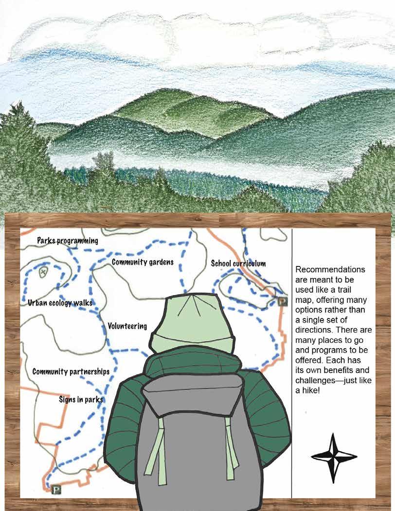
This section moves from analysis to recommendations. These are grouped into:
• Operational scenarios which focus on methods, topics, and audiences to consider prioritizing.
• Spatial scenarios which focus on potential locations to prioritize. These include both “accessible” spaces—areas walkable from priority neighborhoods and spaces “worth the trip”—areas that are more ecologically rich, but farther away.
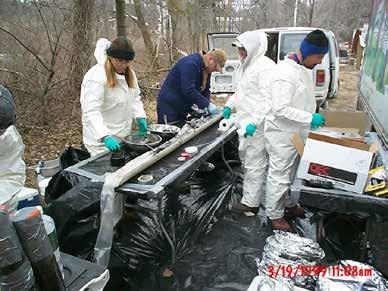
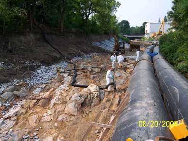
In 2020, the EPA approved the final plans for the “Rest of River” cleanup to be implemented by GE, to remove additional sediment containing PCBs from the Housatonic river, focusing on the first 11 miles in the City of Pittsfield and the towns of Lee and Lenox. This work will take 13 years to complete and cost an estimated $576 million (Deegan). According to conversations with GE, planning and construction of the Upland Disposal Facility is underway now, outside of Pittsfield. The next phase of remediation work in Pittsfield will begin in 2027, which allows some time to develop a communication and awareness strategy for the community.
Additionally, the City of Pittsfield is considering establishing more passive educational materials
such as signs in parks and near cleanup activities. Signs would be present long after the cleanup is completed. These signs could educate on the ecosystems and their value, answering the question of why pollinator gardens were established and wetlands restored. They can also educate the public on what activities are safe and encouraged in each restored area, both for the protection of the ecosystem and the humans involved. Conversations with residents and Westside Legends revealed that some people in town are still unsure of what they can safely do in or on the river, or on land containing PCB-contaminated soil. More signs that clearly elucidate how the water and land can be interacted with could build trust within a community that has been so impacted by environmental issues.
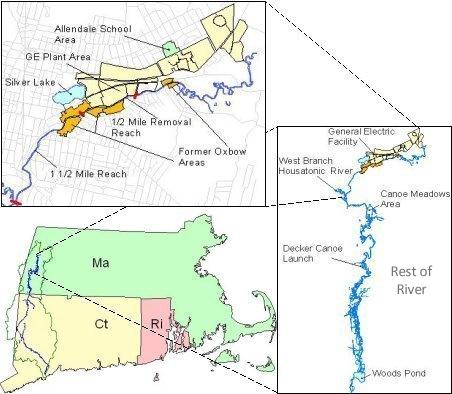
Pittsfield and regional context for the Rest of River cleanup, via EPA
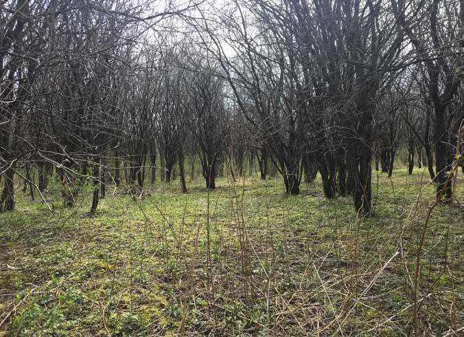
For example, GE is sponsoring a cleanup in Kirvin Park that involves invasive species removal, pollinator garden establishment, and wetland restoration (“Kirvin Park Floodplain and Wetland Restoration”). There have been community presentations on these plans and activities, including an educational session for a Pittsfield High School science class. It could be beneficial to the community to have more of these public meetings and forums that raise awareness of both the actual efforts in town, and the reasons why these are ecologically valuable.
Lastly, these opportunities are likely to be co-led by GE and the City of Pittsfield, as they involve publicly visible projects, community messaging, and public land. While there may not be a direct linkage between BNRC and the cleanup efforts, the environmental legacy of GE and the cleanup efforts are so integral to the landscape of Pittsfield that they will be referred to in many of the other recommendations in this report that are more relevant to BNRC.
Cataloging and maintaining the inventory of a broad and evolving network of community organizations and non-profits is challenging, especially with the high level of community activity and involvement in Pittsfield. It is an ongoing exercise to keep a finger on the pulse of events and activities offered. Activities fluctuate seasonally, and non-profits are particularly dependent on the time and resources of their founders and volunteers.
This project resulted in about 70 engagements with Pittsfield residents, which is not a significant representation of the population, particularly in the populations identified as underserved. In the survey and tabling session, a self-selecting group of people already involved in community activities responded. It may be more successful to engage with community members via the organizations that are already interfacing with residents of Pittsfield, and particularly marginalized communities that may not be able to attend community meetings.
Establishing a more physical presence in Pittsfield could both raise awareness of BNRC with residents, and give BNRC a deeper understanding of Pittsfield generally. A BNRC Open House or Office Hours more regularly in Pittsfield could be a point of engagement for residents. The Berkshire Athenaeum already offers a number of brochures by BNRC, but
having someone spend a few hours once a month or once a quarter in a high-traffic area could satisfy two objectives: making BNRC, their activities, and properties more visible in Pittsfield, and allowing BNRC to hear directly from residents what they already know about BNRC and what they are interested in seeing more of.
These sessions could be in a rotating location, where in the winter the Open House is held in the Berkshire Athenaeum, and the summer is held in local parks, such as Westside Riverway Park, The Common, or a community garden. Having multiple locations and neighborhoods draws more people into the conversation with BNRC, and more equitably distributes information. Hosting these sessions in partnership with community organizations like Westside Legends or 18 Degrees may also draw a larger audience.
BNRC may also want to test which places result in the most helpful conversations. The Berkshire Athenaeum tabling session resulted in fewer and less relevant conversations than the Conway team expected, but a single session cannot determine if this is a fluke or a pattern. Through trial and error, BNRC may gain an understanding of the most engaged places in Pittsfield. They may also find more benefit in online engagements, such as social media videos that highlight Pittsfield open spaces, hiking 101 workshops, or Q&A livestreams.
An ongoing focus group of environmentally focused community organizations could serve Pittsfield on a longer term basis. If led by BNRC, this could help BNRC build relationships with community leaders and get a deeper understanding of Pittsfield as a whole, as well as increasing cross-organization communication to decrease silos. With more understanding of the offerings of other organizations, there could be more opportunities identified for collaboration.
According to conversations with Berkshire Regional Planning Council (BRPC), there had been a quarterly meeting of outdoor recreation organizations for approximately a year, which provides a precedent for
a focus group of this nature. These were zoom calls that had between 20 and 50 participants, including BNRC. The calls had a seasonal focus and featured updates from organizations throughout Berkshire County. BRPC initially received grant funding to set this up, and needed to sunset the framework once the grant ran out in 2022.
BNRC could independently organize a similar cadence of calls with Pittsfield organizations they already partner with using the BRPC meetings as a blueprint. This could allow a more regular and thorough inventory of environmental education programming, since there is so much variation throughout the year.
Because of BNRC’s limited history of environmental education, partnering with existing community organizations that already host programs in Pittsfield may be a more efficient method for BRNC–both because these community organizations already have programs and teachers, and because they are connected with the needs of the Pittsfield community.
As detailed in the Community Organization Inventory, BNRC already has many partnerships with organizations in Pittsfield, both with environmental education and without. As such, initial ideas for BNRC to increase access and support programming include:
• BNRC could provide funding or assistance services like transportation to their existing partners. BNRC states that financial support for other organizations is an infrequent occurrence, but happens on an as-needed basis, such as stipends for instructors. Example organizations include Latinas 413 and seeing rainbows.
• BNRC could work with their environmental education partners outside of Pittsfield to expand programming into Pittsfield spaces, particularly those that are walkable from dense Environmental Justice neighborhoods, as shown on page 23. Example organizations include Black and Wild and Unpaved Trails for All.
• BNRC could work with its partners in Pittsfield who do not offer environmental education to share information with the population they serve about programming opportunities in their neighborhood. Example organizations include Westside Legends and Downtown Pittsfield Inc.
• BNRC and its partners could more heavily promote educational opportunities across organizations to raise awareness of events and groups and foster a culture of information sharing.
If BNRC seeks to expand its in-house educational capabilities, they may need to develop a strategy for supporting that programming. Comparably-sized land trusts in the state, such as Kestrel Land Trust and Greenbelt, have limited educational events, and the events that do exist are co-hosted with an education-based organization, according to their websites. Larger land trusts in the state, such as Mass Audubon and The Trustees of Reservations, offer more comprehensive educational programs throughout the year. These organizations have Director level positions focused on education, in addition to onstaff educators. This may be a model to emulate if BNRC has aspirations to support more education work internally.
Another precedent to consider is the Hitchcock Center for the Environment in Amherst, MA. The Center’s mission is “to educate and to inspire action for a healthy planet,” and offers volunteer opportunities in support of environmental education. The Pittsfield resident survey indicated that 57% of respondents were interested in more volunteer opportunities related to environmental education, and it may be a particularly good opportunity for retirees in the environmental or education sectors. The Hitchcock Center also runs an independent study program under their Education Director that allows interns to develop curriculum for summer camps or events, which could be an interesting way for BNRC to build out their programming (“Hitchcock Center for the Environment | Education for a Healthy Planet”).
One low-barrier way to involve youth on all levels of the engagement spectrum is to create or run programs in Pittsfield schools. This removes constraints to environmental education access such as students’ financial ability, vehicular access, and prior knowledge or interest. Massachusetts has clear curriculum guidance by grade level that could be supported by hands-on environmental science experiences.
Schools and teachers are more likely to be willing to partner with BNRC if the educational programs they create or promote are in clear alignment with science curriculum goals.
As an example, the following selections of the Grade 3-5 requirements for Science & Technology (Science and Technology/Engineering (STE)) seem particularly aligned with environmental education activities:
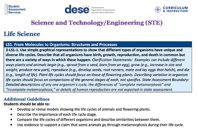
In these guidelines, plant biology, pollination, and photosynthesis play a central role. These would be demonstrated in at least two of the scenarios suggested in this report (community gardens and an urban ecology walk). If these were to be incorporated into BNRC’s programming and made available to local students, teachers and schools may be more likely to participate.
BNRC might consider consulting with teachers about their level of interest in programming to ensure they support their lesson plans, field trip activities, and/or other educational materials. BNRC may also find inspiration in other local non-profit precedents, such as Mass Audubon’s At-Your-School programs, which included a Waterways program in Pittsfield’s Morningside School that taught fifth graders about the Housatonic Watershed over the course of ten weeks (Audubon).
BRNC could consider developing a series of urban ecology walks in Pittsfield as a form of place-based environmental education. Urban ecology walks invite participants to explore ecological processes, environmental history, and human-nature relationships within the built landscape. Walks can help participants understand how ecological systems operate within cities and how urban communities interact with natural areas.
Locating urban ecology walks within Pittsfield’s city center could help improve accessiblity of programming for residents living in areas identified as Environmental Justice populations. Developing walk
routes that begin in the city center, such as near the Berkshire Athenaeum could help reduce barriers to participation by locating programs within walking distance of neighborhoods with higher population density.
One possible model would be a walk beginning near the Berkshire Athenaeum and traveling toward a nearby green space, such as First Street Common. Along the way, facilitators could highlight topics such as urban tree canopy, stormwater management, wildlife habitat, and the ways that city infrastructure shapes ecological systems.
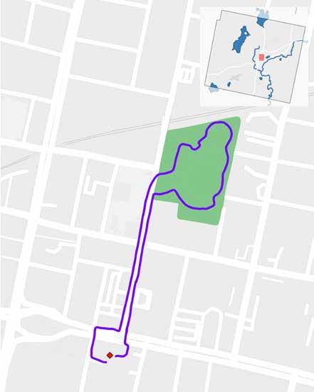
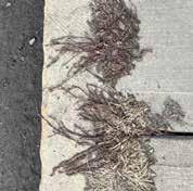
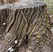
Urban ecology walks could also incorporate themed programming, such as urban foraging walks that introduce participants to edible and useful plants commonly found in city landscapes. Foraging programming could also incorporate discussion of how to assess safe harvesting locations in an urban environment historically impacted by industrial contamination. These walks could help people learn how to identify plants that grow in sidewalks, vacant lots, and neighborhood green spaces. Programming such as this can help participants see their neighborhoods as landscapes that provide ecological and cultural resources, strengthening connections between residents and the land around them.
These walks could also include discussions of Pittsfield’s environmental history, including the city’s
industrial development and legacy of contamination associated with GE. Connecting ecological observations to local history can help participants better understand the relationships between environmental change, industry, and community health.
Accessibility is an important consideration. Walk routes could be developed with variable lengths and levels of physical exertion, including shorter routes on sidewalks or paved paths and longer options that extend into nearby parks or forest trails. This approach would allow participants with different mobility levels to engage with the program.
Urban ecology walks could be offered as guided programs and complemented by self-guided materials, such as printed maps allowing residents to explore the route independently.
“Profiles of Spontaneous Urban Plants” is a project developed by the landscape urbanism firm Future Green Studio and documented through Urban Omnibus. The project explores the ecological and cultural value of spontaneous urban vegetation. These plants are often dismissed as “weeds” that thrive in sidewalk cracks, vacant lots, and other overlooked spaces within urban landscapes.
Future Green Studio argues that spontaneous plants provide ecological benefits similar to those of intentionally planted landscapes. These species require no human assistance to establish themselves and often thrive in extreme urban conditions while contributing to urban biodiversity and environmental resilience. The studio notes, “wild urban plants can provide real ecological benefits, and are the overlooked backbone of an emergent green infrastructure.” (Future Green Studio)
To bring attention to these plants, Urban Omnibus staged a temporary public intervention along 3rd Street in Brooklyn, New York. Spontaneous plants were outlined in bright yellow paint, highlighting species that are normally ignored or removed. This intervention encouraged passersby to notice and reconsider the ecological value of everyday urban vegetation.
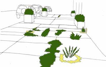
This project demonstrates how small interpretive interventions can invite a shift in public perception of urban ecology. By drawing attention to plants that already exist within the urban landscape, observers can develop new ways of seeing and engaging with their environment. Similar approaches could inform urban ecology walks in Pittsfield by helping participants identify spontaneous plants, learn about their ecological roles, and explore opportunities for urban foraging and environmental stewardship.
One scenario for improving access to outdoor environmental education is increasing programming within open space easily accessible to EJ neighborhoods. The map on page 23 and list on page 26 identify these spaces; one is analyzed in more detail in this section.
Westside Riverway Park is a 2-acre lot including a pavilion, canoe launch, and access to the Housatonic River, providing space for both recreation and community gathering. The pavilion was designed as a corridor connecting the street and the water. The park is located near areas of relatively high population density and near environmental justice populations, positioning it as an accessible location for environmental education.
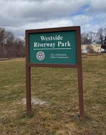
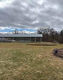
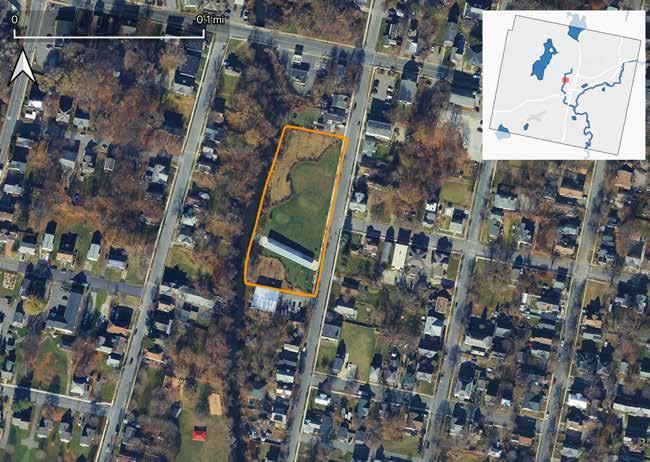
Plans for Westside River Way Park emerged in 2007 as part of an effort to strengthen connections between Pittsfield’s parks and trail systems (Landes).The project was funded through a $400,000 construction grant from Massachusetts Executive Office of Energy and Environmental Affairs, matched by $175,000 from the City of Pittsfield and a $100,000 donation from the Jane and Jack Fitzpatrick trust. The two-acre park was designed and programmed through a two-year community visioning process led by local residents and organizations.
The park’s design was developed by Pittsfield-based designers Tessa Kelly and Chris Parkinson of the firm ARCADE, who worked closely with community members to shape the site. A key partner in this process was Westside Legends, a neighborhood organization that advocated for the park’s creation and
continues to support programming and stewardship of the Westside neighborhood today. Reflecting on the design approach, Parkinson described the importance of working with the existing urban landscape and community narratives:
“A lot of cities like Pittsfield, these deinvested cities, have an urban fabric that in many ways is a remnant of the past. And I think what we do when we look at a place like Pittsfield is try to take that fabric and try to find narratives or ways to reinvent that fabric and make it belong to the present. Taking that idea to a project like this Westside Riverway Park, a lot of the way we think about projects is trying to think of how we can bring a narrative and a design process that involves a community, that involves the city, and make it some way tell a story of the place to make it important to the contemporary and present moment.”
Westside Legends is a neighborhood-based nonprofit that has played an important role in community organizing and neighborhood revitalization in Pittsfield’s Westside neighborhood. Originally founded as a Facebook group highlighting the accomplishments of athletes from the area, the organization has since grown into a broader effort to strengthen community connections and create opportunities for residents.
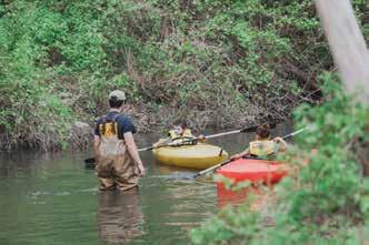
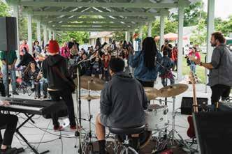
Today, Westside Legends organizes neighborhood events such as Memorial Day block parties, supports housing initiatives including rehabilitation of homes for new residents, and works to foster a sense of pride and belonging within the Westside. The organization was also an early advocate for the creation of the Westside Riverway Park and remain connected to ongoing events at the site.
Westside Riverway Park is subject to an Activity and Use Limitation (AUL) due to the site’s history of contamination associated with the Housatonic River. Prior environmental investigations identified elevated concentrations of polychlorinated biphenyls (PCBs), petroleum hydrocarbons, and several metals in site soils. As part of the remediation, a soil cover system was installed across the site to reduce potential exposure to contaminants.
The AUL establishes conditions that allow the property to be safely used as a public park while limiting activities that could disturb contaminated soils beneath the surface (MassGIS). Permitted uses include recreational activities, commercial and industrial uses, and construction activities conducted in accordance with the AUL requirements. Residential uses, schools, and other uses involving routine soil contact are restricted.
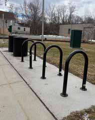
Westside Riverway Park does not have a dedicated parking lot. Visitors generally park along Dewey Avenue or nearby residential streets and walk into the park. There is a bike rack for those traveling to the park by bike.
To maintain the integrity of the remediation work, the AUL requires that surface covers be regularly inspected and maintained. Any excavation or soil disturbance below the surface must follow an approved Soil Management Plan (SMP) and Health and Safety Plan (HSP). In addition, soil removal or relocation is restricted unless conducted in accordance with the conditions detailed in the AUL.
These limitations do not prevent the site from functioning as a park but do shape how the landscape can be used and managed. The presence of the AUL may explain some of the ways community members currently use the park. Westside Legends noted that during their events, attendees are encouraged to bring chairs rather than sit directly on the grass. While this practice may stem partly from longstanding perceptions about the contamination in the Housatonic River, it also reflects broader uncertainty about what types of interaction with the landscape are considered safe.
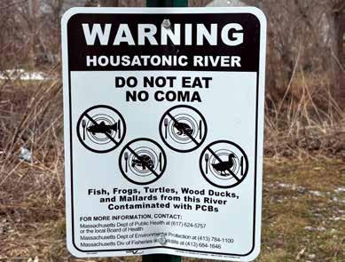
Signs at Westside Riverway Park are limited. The site includes a basic park identification sign near the pavilion, a sign providing an overview of the Housatonic River, and a warning sign about consuming animals from the river.
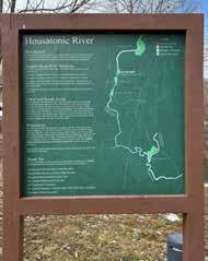
Westside Riverway Park presents an opportunity for BNRC to collaborate with Westside Legends to support community-led engagement with the river and surrounding landscape. For example, Westside Legends’ annual Memorial Day block party already brings large numbers of neighborhood residents to the park, where partners such as Berkshire Environmental Action Team provide canoe and kayak experiences on the Housatonic River. Westside Legends enthusiastically encourages BNRC to participate in their events.
Building on these existing gatherings, there may be opportunities to introduce additional environmental education infrastructure and programming that supports Westside Legends’ work while responding to community interests. Interpretive signage, hands-on activities, and partnerships centered on the river, local ecology, and neighborhood history could help deepen connections between residents and the landscape while reinforcing the park as a community gathering space. There may be an opportunity for future passive educational elements: signs could help visitors understand the river’s ecology, pollinator habitat, and the broader environmental history of the Housatonic River.
At the same time, engagement around the river must acknowledge the long history of contamination in the Housatonic River and the uncertainty this has created for many residents of Pittsfield. For generations, community members have been told the river is unsafe, contributing to lingering fears and stigma associated with contact with the water or soil. Environmental education efforts at the Westside Riverway Park therefore have the opportunity not only to share ecological knowledge, but also to help clarify what activities are safe today to rebuild trust with the river over time.
Members of WSL expressed strong interest in establishing a community garden in the neighborhood. Raised-bed gardens with healthy soil could offer one potential approach that aligns with AUL restrictions while supporting community interest in growing food and gathering around shared stewardship activities. Such an approach could create opportunities for environmental education, food access, and neighborhood engagement while maintaining the soil cover system required at the site for collective safety.
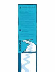
The Ghost Rivers project in Baltimore offers a precedent for interpretive signage that combines public art and environmental storytelling. The project traces a path of a buryied urban stream, through a series of installations across the city. Sculptural interpretive signs feature cut-out river shapes that allow visitors to see the historic path of the stream.
Based on the community organization inventory on pages 35-38, there are few low-barrier, neighborhood-embedded environmental experiences in Pittsfield’s central neighborhoods that allow for spontaneous engagement. The programming that exists is largely organized for people who are already at the stage of interest or engagement.
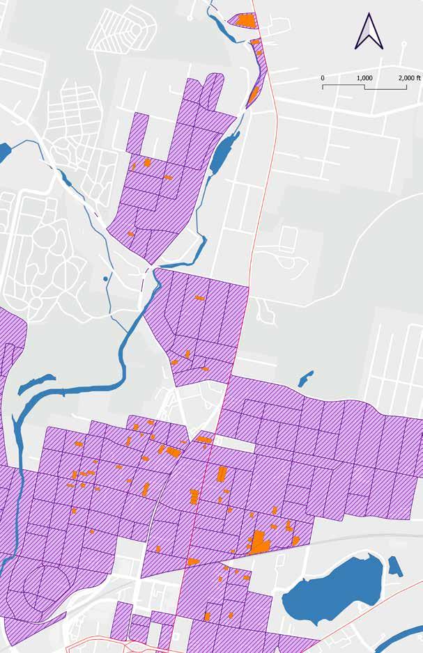
This section explores a scenario in which BNRC selects and acquires a vacant lot for conversion to community gardens to use as the operational foundation for a model of environmental education outreach that is new to BNRC. The scenario has two components: a GIS-based methodology for identify-
ing candidate sites and a theory of change explaining how garden-based programming could serve as a pipeline to deeper environmental engagement.
BNRC is well-positioned to make a difference here. According to the BNRC administrators working on this project, their organization has land acquisition capacity, conservation expertise, and a commitment to better serving Pittsfield. A community garden is a form of land conservation. It takes a vacant lot out of speculative development and converts it into a living, ecologically functional, publicly accessible green space.
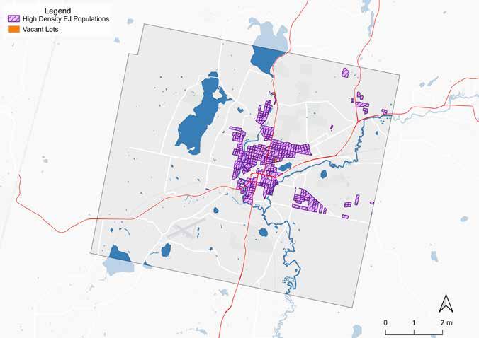
Candidate community garden lots were identified using Pittsfield’s parcel data combined with state land use layers.
The foundation of the analysis is the MassGIS Level 3 Assessor Parcel layer for Berkshire County, which includes land use classification codes, ownership information, and parcel geometry for every assessed property in the Commonwealth. Parcels were filtered to include those classified under the following use codes identifying undeveloped land not currently in productive use: residential vacant (130 — developable, 131 — potentially developable, and 132 — undevelopable), commercial vacant (390, 391, 392), and industrial vacant (440, 441, 442). Code 132 parcels, though classified as undevelopable for conventional construction, were retained on the grounds that irregularly shaped or undersized lots may still accommodate raised beds and a small gathering area. Industrial vacant parcels were retained but
should be flagged for additional scrutiny given the elevated likelihood of soil contamination in this category.
The resulting candidate set includes 67 parcels within the areas identified in the Pittsfield Demographics section as high density EJ populations. These are inventoried on pages 85-86.
This methodology has data limitations. An otherwise suitable site may not be held by an entity interested in selling it. A clean parcel record does not capture physical site conditions such as informal use patterns or deed restrictions that could affect use. GIS analysis is also insufficient to identify access constraints or soil safety. An environmental site assessment and community consultation would be advised before commitment. The spatial analysis nonetheless provides a reasonable, data-driven starting point.
A relationship with the environment develops through experience, and experience requires access. For residents of Pittsfield’s most underserved neighborhoods, existing environmental programming may be inaccessible, not only geographically (i.e. within walking distance of underserved residents) but socially, in that it tends to assume a particular prior relationship with nature. This is illustrated by an older community member at a tabling session. When asked if he would like to talk about environmental education in Pittsfield, he was quick to state “I’m not a tree hugger.” Despite this, he eventually recalled an encounter with a bald eagle which left him awestruck. Simply reminiscing about this seemed to have affected him deeply. That he did not relate to the term “environmental education” while a chance encounter with a bald eagle clearly moved him suggests a disconnect worth taking seriously; one that Pittsfield’s industrial history, described earlier in this report, could help explain. This attitude may be a common barrier for adults in Pittsfield. Addressing this may require adding education that does not seem to Pittsfield residents to be at odds with the identity of current and former industrial workers.
This community garden scenario applies the engagement model through a specific entry point: access to growing space for personal food production. The rationale for that entry point begins with a gap in Pittsfield’s existing infrastructure.
Pittsfield currently has seven community gardens in the Westside and Morningside neighborhoods, which might suggest that access to growing space is already adequately provided. However, the overwhelming majority of produce from those seven gardens is committed to the organizations running them, serving food banks, community service programs, and institutional partners rather than individual residents growing for themselves. Only one garden in the city offers fee-based access to private plots, and that garden has just six of them. For a resident who would like to grow food for their own household, Pittsfield offers almost no accessible pathway to do so.
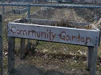
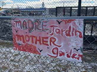
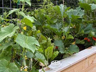
The Athens Land Trust in Athens, Georgia, provides a precedent for how a conservation organization can build community through garden-based programming. Beginning in the early 2000s, Athens Land Trust staff recognized that community gardens could serve as a bridge between their conservation mission and the lowincome neighborhoods where they were also doing affordable housing work. The pivot was modest at first: a single vacant lot, converted at the suggestion of a board member who had noticed drug activity there (Lim). Over time the lot grew into the West Broad Market Garden, a farmers market serving twenty low-income vendors, a Young Urban Farmer program for at-risk high school students, and eventually an incubator farm program providing affordable access to land and equipment for beginning farmers of color (“Athens Land Trust”). The entry point was food. The relationships that grew from it extended well beyond it.
Cornell University’s Garden Mosaics program offers a similar precedent focused specifically on the educational value of garden-based programming in urban communities. Developed through Cornell Cooperative Extension and later adopted as the signature education program of the American Community Gardening Association, Garden Mosaics uses community gardens across the United States as informal science learning environments, engaging youth in hands-on investigation of plants, soils, and ecological processes (Lang). Over its first four years, Garden Mosaics engaged more than fourteen thousand youth across participating cities (Krasny et al.). The curriculum is available at no cost.
The Land Trust Alliance’s 2015 national census of land trusts found that protecting land in urban areas, drawing on a broad volunteer base, and prioritizing local community work were all associated with significantly greater likelihood of a land trust reporting meaningful justice, equity, and access impact (Beckman et al.). In this scenario, all of the above can be done in a community garden.
A local parallel is already underway. Berkshire Botanical Garden runs in-school and after-school programming at several Pittsfield schools through the city’s 21st Century Community Learning Center program. BBG educators work with students two to four days a week on topics including tree identification, pollinators, planting, and harvesting and cooking fresh produce (“Farm and Garden School Programs”). The program serves 240 students from Conte and Morningside Community schools and Herberg and Reid middle schools (Sukiennik). This programming creates a cohort of young people with some foundational ecological exposure who currently seem to have no obvious next step in their own neighborhood, per the education inventory. A BNRC garden could provide that next step, and a formal coordination with BBG to sequence its school programming with garden-based follow-up activities could be an early partnership priority. There may also be an opportunity to assist this existing program with funds. The 21st Century program’s federal funding is currently under threat; should that funding lapse, the school-based touchpoint this scenario depends on could be disrupted (Sukiennik). In a response to the survey, BBG reported that they still provide in-school and after-school programming for the above schools, but it did list “transportation and grant funding” as needs.
The stages described in this report’s engagement model apply to the community garden scenario as follows.
Stage One — Awareness. A well-tended garden on a previously vacant lot communicates, without a word of programming, that someone has invested in this neighborhood. Signs identifying the garden as a BNRC initiative gradually build name recognition among residents who may have had no previous encounter with the organization beyond perhaps a visit to Mahanna Cobble or The Boulders.
Stage Two — Low-Barrier Engagement. The garden’s primary function at this stage is to offer residents actual growing space, their own raised bed or plot where they can grow food for their family with BNRC’s support. This is distinct from the city’s existing gardens, where produce serves institutional rather than individual purposes. A resident who grows a summer’s worth of herbs or tomatoes has a stake in the garden that no drop-in activity can replicate. Layered on top of that personal growing experience, drop-in programming such as seed starting, soil observation, pollinator identification, and plant propagation provides additional touchpoints for residents who want to engage beyond their own plot and serves as an entry point for neighbors without a bed of their own.
Stage Three — Deepening Participation. Repeat visitors become familiar faces, and familiar faces become informal participants in the garden’s ongoing life. From this relational foundation, garden staff can begin connecting interested residents to BNRC’s broader programming. A person who has spent several Saturday mornings tending their bed alongside the same BNRC staff member is more likely to show up for a trail event than a person who received a postcard. The BBG school programming described above adds a reinforcing dimension here: a student who has encountered ecological concepts through BBG and then finds a working garden in their own neighborhood is experiencing the pipeline from two directions at once.
Stage Four — Constituency Building. Over time, the garden becomes a site of ongoing relationship between BNRC and a neighborhood, a place that feels like it belongs to the people who live near it. Residents who have moved through the earlier stages could become advocates, volunteers, and eventually members, converting a neighborhood where BNRC has no presence today into one where BNRC is understood as an organization that listens and shows up.
Westside Legends’ successful advocacy for the Westside Riverway Park and deep knowledge of the community make them an invaluable partner for site selection and garden operations. A garden that opens in relationship with Westside Legends could begin with a level of community buy-in that might otherwise take years to build independently.
18 Degrees, which already co-promotes environmental education through its family and youth service networks, represents a direct means of connecting with underserved households.
Berkshire Botanical Garden’s in-school programming could segue into neighborhood gardens.
Latinas 413 serves Spanish-speaking residents of inner-city neighborhoods and already provides Spanishlanguage materials and programming as a matter of course. Communications, signage, and programming materials for BNRC garden sites should be bilingual from the outset.
Pittsfield Public Schools that already work with BBG represent an opportunity to nurture young people who already have some level of awareness.
Based on feedback from the March 5th, 2026 Pittsfield OSRP community engagement session, drop-in activities should be completable in ten to thirty minutes by a visitor who arrives alone, unannounced, with no prior knowledge and nothing in hand. One participant noted specifically that time constraints were a primary barrier to participation in scheduled environmental education of any kind. This suggests barriers to engagement are often logistical rather than motivational.
The drop-in activities are secondary, however, to the garden’s primary function: providing residents with their own growing space. Site design should reserve a meaningful portion of each garden’s total bed area, as individual residential plots available to neighbors at no cost or a nominal seasonal fee, modeled on allotment garden traditions. This would directly address the apparent absence of such space in Pittsfield’s existing community garden infrastructure. The remaining bed area can be managed collectively for demonstration plantings, drop-in activities, and programming use. Such activities should be adapted on a per-garden basis with the plot-holders’ use patterns in mind to prevent conflicts of use.
Examples of drop-in activities for these community gardens include:
Plant propagation from cuttings. Participants take a cutting from a hardy herb, place it in water or growing medium, and take it home with a card explaining next steps.
Seed starting. Participants fill a small biodegradable pot with a growing medium, plant one or two seeds of a vegetable or native flower, label it, and take it home. The activity takes little time and produces a tangible outcome that extends the relationship with the garden beyond the visit. For residents with their own plot, it doubles as preparation for their growing season.
Soil jar observation. Participants fill a clear jar with soil from the garden, add water, shake it, and watch the layers settle. A laminated guide explains what each layer represents and how soil structure affects plant growth. The activity takes approximately fifteen minutes and requires minimal facilitation.
Pollinator observation and tallying. A laminated ID sheet depicting common Berkshire pollinators allows visitors to sit quietly in the garden and record what they observe. Results posted on a shared chart accumulate over time, giving participants a sense of contributing to something ongoing.
Plant identification walk. Visitors take a self-guided walk around the garden perimeter using a laminated ID guide with numbered markers. Native plants, garden cultivars, and naturalized non-native plants all offer educational opportunities. Staff can accompany interested visitors and extend the activity into a conversation about native plant ecology or seasonal change.
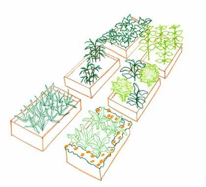
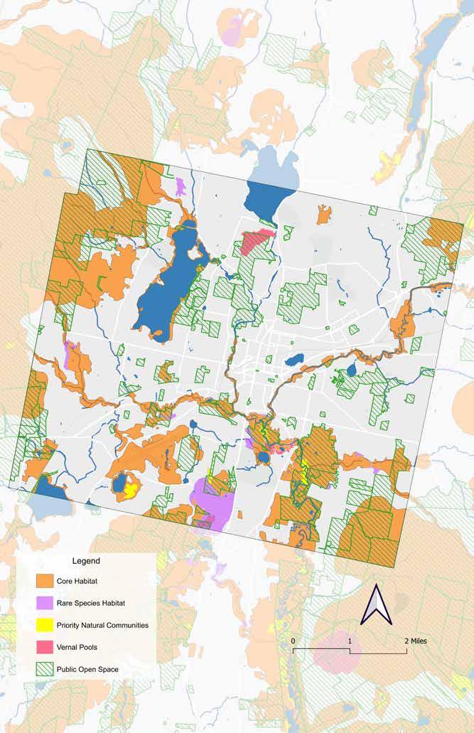
BioMap3 was used as another lens with which to identify spatial opportunities for conservation and environmental education. Developed by Mass Wildlife & The Massachusetts chapter of The Nature Conservancy, BioMap3 identifies lands and waters critical for biodiversity and climate resilience. The many features available on this map were filtered to those most relevant from an educational and conservation perspective:
• Vernal pools
• Core habitat areas
• Rare species habitat
• Priority natural communities
It is important to conserve these features and to educate the public about what makes them special.
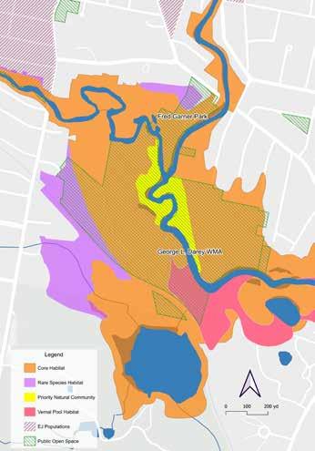
The George L. Darey Wildlife Management Area contains a BioMap Priority community, vernal pool habitat, and rare species habitat in addition to core habitat. Its amenities are limited to a trail and an informal parking area, but its adjacency to the more approachable Fred Garner Park could present an opportunity to ease Pittsfield residents into lessdeveloped outdoor spaces.
Fred Garner Park is within a quarter mile of the southeastern corner of the high-density underserved populations in the city center. The park is welcoming, with a prominent sign marking the entrance as well as mown fields and picnic tables near the parking lot. Beyond this area suited for larger groups, the park also features trails and a boat ramp through a natural setting more like what is found in the neighboring George L. Darey WMA.
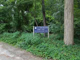
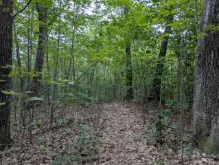
Spatial data from the Natural Heritage & Endangered Species Program (NHESP) was used to take a deeper look at unique ecological features of Pittsfield. NHESP is responsible for the conservation and protection of hundreds of species that are not hunted, fished, trapped, or commercially harvested in the state, as well as the protection of the natural communities that make up their habitats.
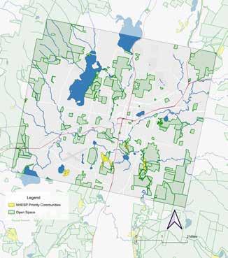
Observing where this datalayer intersects with BNRC properties highlights the Dubow Reserve, which is a 35-acre permanently conserved site in the south of Pittsfield. It consists of a hardwood forest on the north slopes of South Mountain, and was a donation to BNRC from the Dubow family. The property can only be accessed by crossing a wetland and does not contain managed trails (“DubowBNRC”). As such, it is the least visited of the three BNRC owned properties in Pittsfield.
According to NHESP, Dubow Reserve is home to two natural communities, groups of plant species that recur together in particular environmental conditions and are of biodiversity conservation importance. These include the Red Oak - Sugar Maple Transition Forest (#1 on map below) and Red Maple - Black Ash - Tamarack Calcareous Seepage Swamp (#2 on map below).
The latter is considered S2 (Imperiled) by NHESP, meaning there are few remaining instances in Massachusetts (Bureau).
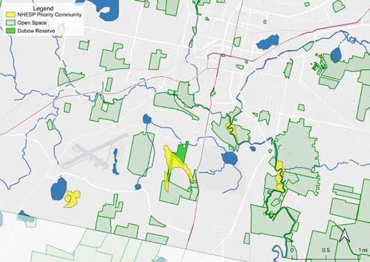
While this land is already being conserved for ecological reasons, there is an opportunity for education about these natural communities. Teaching the community of Pittsfield about the rare natural communities in their town can reinforce the importance of conservation, the work that BNRC does, and town pride. This could look like a guided onsite visit for people deeply interested in conservation and rare communities and teaching them to better appreciate them while respecting the sensitivity of their ecosystems. Alternatively, it could be an awareness campaign of why this land is an important part of BNRC’s conservation strategy, without any onsite component to ensure the ecosystem remains protected.
In addition to general education at or about Dubow Reserve, BNRC could expand their partnership with Black and Wild, whose mission is to connect Black, Indigenous, and People of Color with nature through mindful wilderness trips and ancestral skills, including multi-day campouts focused on basketry weaving with willow (“Black&Wild”).
Black and Wild mainly operates in East Chatham, New York, which is about 20 miles west of Pittsfield, but locates its educational events based on availability and organizational partnerships. Its founder lived in Pittsfield previously and maintains a connection to the community. Partnering with indigenous communities on programming and land management in Pittsfield could be part of a larger and longer reconciliation of the history of people in this land, as the Stockbridge-Munsee tribe, now primarily located in Wisconsin, were forcibly removed from the Berkshires via upstate New York (“Tribal History Timeline – Stockbridge-Munsee Community | Band of Mohican Indians”).
Black ash has also been used in indigenous basketry for centuries, and is currently under threat from the emerald ash borer. In 2017, the IUCN listed black ash as critically endangered (Arboretum et al.). BNRC may be able to develop educational programming, with the input from Black and Wild, to bring awareness to both the ancestral practice of basketry weaving, and the conservation importance of this endangered species.
This scenario, when applied to the Dubow Reserve, falls on both the “more engaged” and “more natural” ends of the environmental education spectrum and is less accessible to the general public: It is located farther from the walkable center of Pittsfield, requires transportation, and does not yet have an easy access point. However, despite those limitations, it has the benefit of providing a rarer ecological experience, and uses an existing BNRC property in Pittsfield.
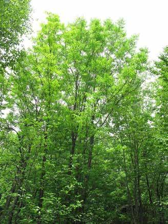
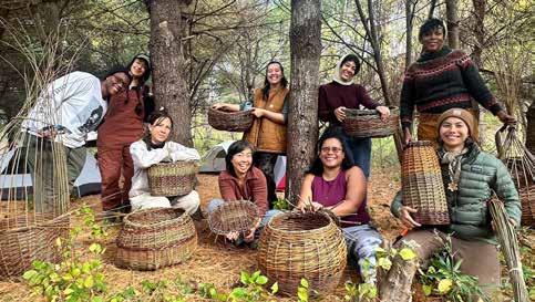
Conte
Survey results can be accessed digitally at: rb.gy/dpgewq
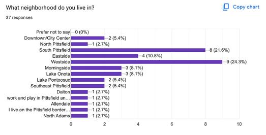
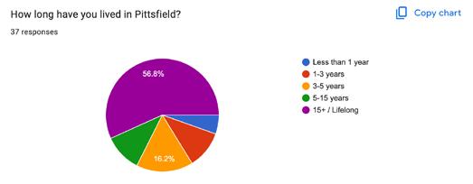
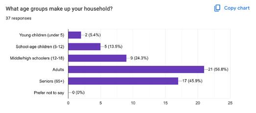
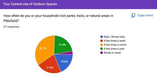
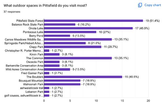
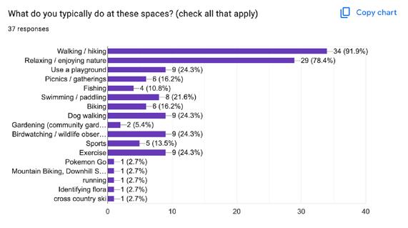
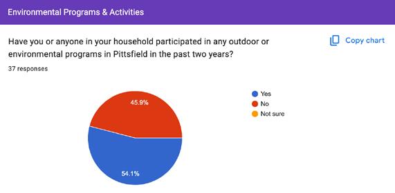
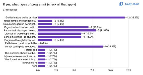
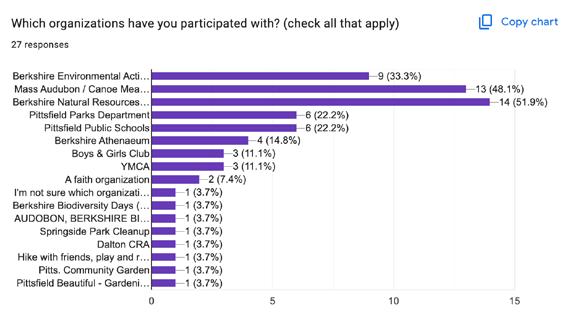
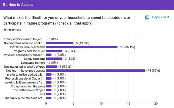
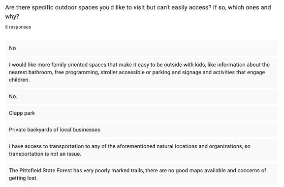
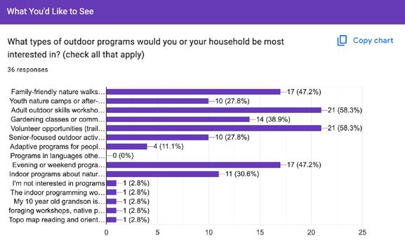
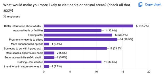
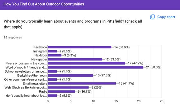
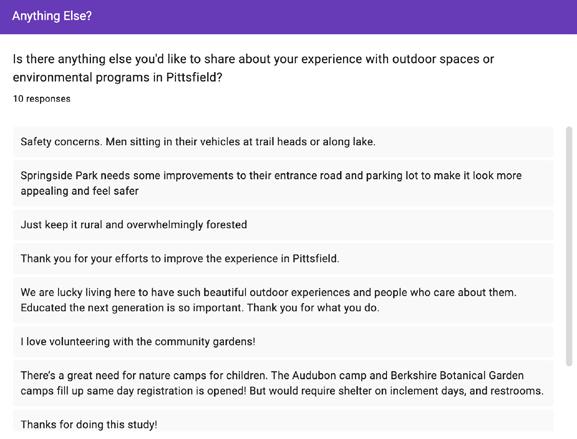

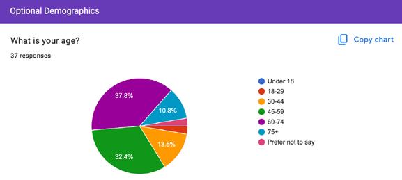
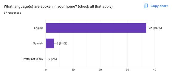
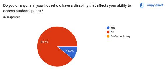
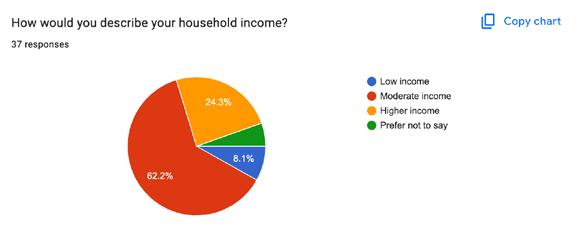
Survey results can be accessed digitally at: rb.gy/dpgewq
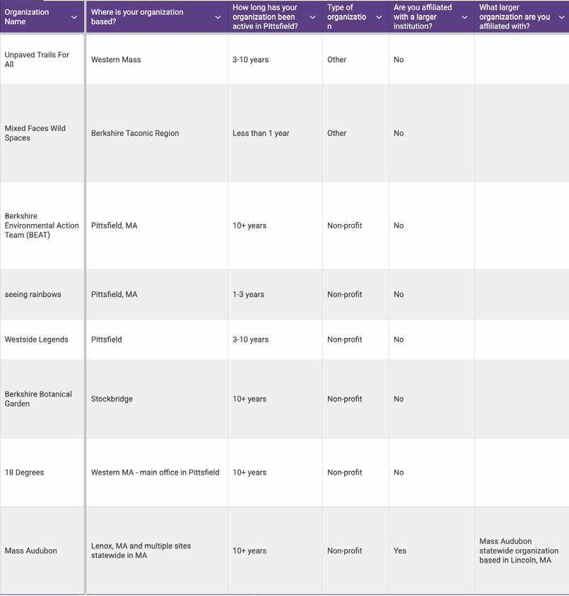
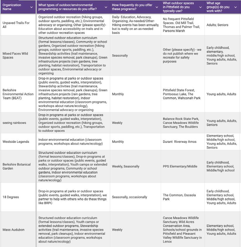
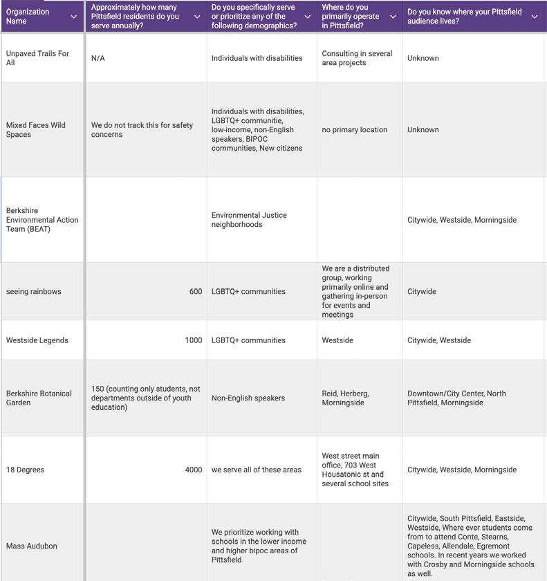
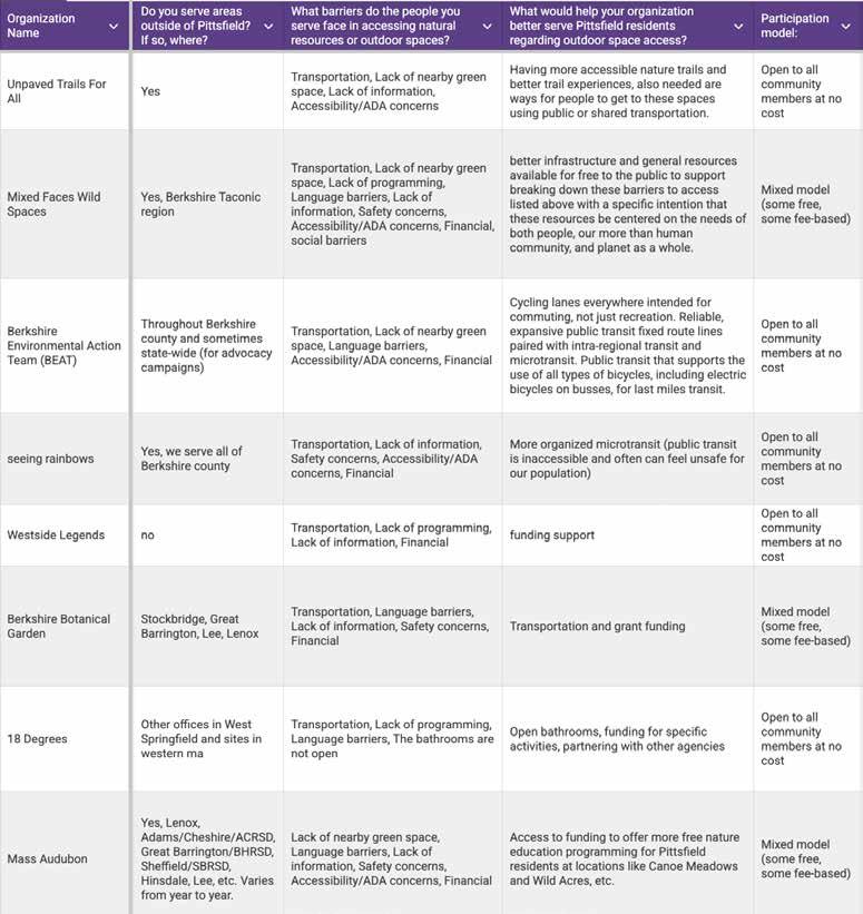
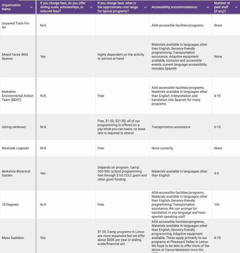
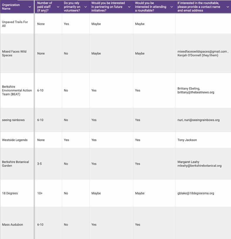
WELLINGTON AVE 0.139 CAVALIER DARTMOUTH PROPERTIES LLC
44 LINCOLN ST 0.103 FORTY FOUR LINCOLN RE LLC
27 LINCOLN ST 0.095 COZZAGLIO JILL M
ORCHARD ST 0.403 FIRST ON SECOND LLC
ORCHARD ST 0.403 FIRST ON SECOND LLC
FIRST ST 0.167 BERKSHIRE MEDICAL CENTER INC
FIRST ST 0.17 BERKSHIRE MEDICAL CENTER INC
FIRST ST 0.12 BERKSHIRE MEDICAL CENTER INC
FIRST ST 0.23 BERKSHIRE MEDICAL CENTER INC H100012008
NORTH ST 0.331 PITTSFIELD STANLEY WORKS LLC
MELVILLE ST 0.148 MOBY PROPERTIES LLC
SECOND ST 0.071 RALINE ELIZABETH T/L H100006013
SECOND ST 0.086 HURRICANE PROPERTIES LLC
52 SEYMOUR ST 0.149 PEPE’S PROPERTIES LLC
KENT AVE 0.157 PITTSFIELD STANLEY WORKS LLC
KENT AVE 0.223 BERKSHIRE MEDICAL CENTER INC
KENT AVE 0.149 BERKSHIRE MEDICAL CENTER INC
697 NORTH ST 0.066 BERKSHIRE MEDICAL CENTER INC H100017010
KENT AVE 0.112 BERKSHIRE MEDICAL CENTER INC H100017001
18 LINDEN ST 0.36 FIVE WITH EVERYTHING LLC H100019003
SEYMOUR ST 0.081 SILVA RICARDO N H100023011
FENN ST 0.267 SECOND AND FENN NOMINEE TRUST H090015009
FENN ST 0.124 RICHARDS JEREMY T/L I090013023
WALLACE PL 0.089 SECOND STREET RENTALS LLC H090015031
PLEASANT ST 1.32 DA SILVA MARCIO JAOA I100002301
PLEASANT ST 1.02 DA SILVA MARCIO JAOA I100002026
PLEASANT ST 0.097 WALKER COREY I100001004
OAK ST 0.273 JRCR REALTY LLC I100003008
PLEASANT ST 0.098 LEACH STEVEN J T/L I100001006 12 OAK ST 0.174 JRCR REALTY LLC I100002002
CHERRY ST
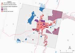
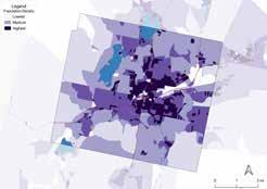
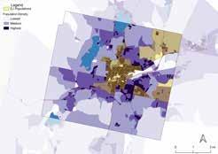
Redlining Page: 11
University of Richmond: Mapping Inequality: Redlining in New Deal America
Environmental Justice Populations Page: 12
MassGIS:
2020 Environmental Justice Populations (2024)
Contamination Sites Page: 13
MassDEP: Hydrography 25k (2019)
MassGIS:
2020 Environmental Justice Populations (2024) Superfund Site Boundaries (EPA, 2026) MassDEP Tier Classified Oil and/or Hazardous Material Sites (MGL c. 21E)
Population Density Page: 14
IPUMS NHGIS; U.S. Census Bureau: Census Tract Population (2020)
Population Density and Environmental Justice Populations Page: 15
MassGIS:
2020 Environmental Justice Populations (2024)
IPUMS NHGIS; U.S. Census Bureau: Census Tract Population (2020)
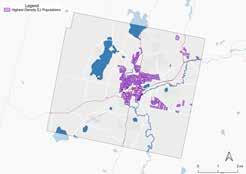
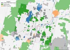
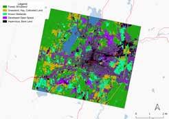
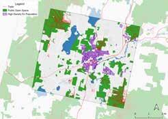
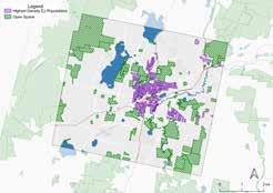
Highest Density Environmental Justice Populations Page: 15
MassGIS:
2020 Environmental Justice Populations (2024)
IPUMS NHGIS; U.S. Census Bureau: Census Tract Population (2020)
Open Space Page: 17
MassGIS: Protected and Recreational OpenSpace (2025)
Land Cover Page: 18
MassDEP: Hydrography 25k (2019)
MassGIS: Land Cover/Land Use (2016)
Trails Page: 19
MassDEP: Hydrography 25k (2019), BRPC Trails (2025)
Highest Density Environmental Justice Populations and Open Space Page: 20
MassGIS:
2020 Environmental Justice Populations (2024) Protected and Recreational OpenSpace (2025)
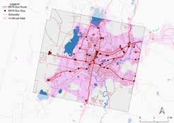
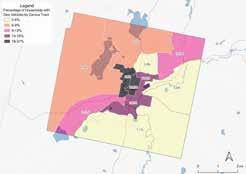
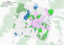
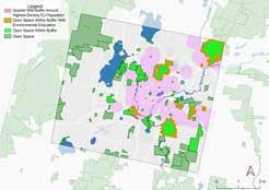
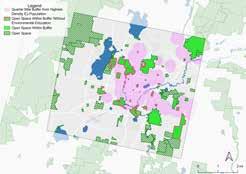
Bus Access to Open Space Page: 22
MassDEP: Hydrography 25k (2019)
City of Pittsfield: Sidewalk Inventory (2021)
DOT:
National Transit Map Routes (2026)
National Transit Map Stops (2026)
MassGIS:
Protected and Recreational OpenSpace (2025)
Households without Vehicles Page: 21
ESRI:
ACS Vehicle Availability (Latest) (2026)
Walkability from Highest Density Environmental Justice Populations and Open Space Page: 23
MassGIS:
2020 Environmental Justice Populations Protected and Recreational OpenSpace (2025)
IPUMS NHGIS; U.S. Census Bureau: Census Tract Population (2020)
Open Space within Buffer with Environmental Education Page: 24
MassGIS: Protected and Recreational OpenSpace (2025)
Open Space within Buffer without Environmental Education Page: 25
MassGIS: Protected and Recreational OpenSpace (2025)
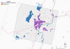
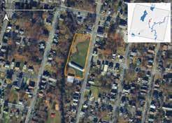
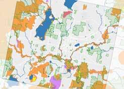
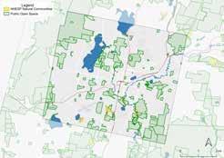
Community Gardens Page: 56
MassDEP: Hydrography 25k (2019) City of Pittsfield: Assessor’s Parcel Data (2025), MassGIS: 2020 Environmental Justice Populations (2024)
Westside Riverway Park Page: 51
MassGIS: Protected and Recreational OpenSpace (2025)
George L. Darey WMA Page: 62
MassDEP: Hydrography 25k (2019)
MassGIS: BioMap: The Future of Conservation (2022) Protected and Recreational OpenSpace (2025)
Dubow Reserve Page: 64
MassGIS: Protected and Recreational OpenSpace (2025) NHESP Natural Communities (2024)
All Maps:
ArcGIS: Light Gray Canvas (2026)
MassGIS: Municipalities (2024)
MassGIS: MassGIS-MassDOT Roads (2025)
Pittsfield: Past & Present
“General Electric and PCBs - Berkshire Environmental Action Team.” Berkshire Environmental Action Team, 17 Feb. 2020, www.thebeatnews.org/BeatTeam/ge-pcbs/. Accessed 27 Mar. 2026.
“Tribal History Timeline – Stockbridge-Munsee Community | Band of Mohican Indians.” Mohican-Nsn.gov, 2025, mohican-nsn.gov/tribal-history-timeline/.
US EPA, REG 01. “EPA Cleanups: GE-Pittsfield/Housatonic River Site.” Www.epa.gov, 30 Mar. 2015, www. epa.gov/ge-housatonic.
Pittsfield Demographics
“Census Reporter.” Census Reporter, 2024, censusreporter.org/profiles/16000US2553960-pittsfield-ma/.
“Environmental Justice Populations in Massachusetts | Mass.gov.” Www.mass.gov, www.mass.gov/infodetails/environmental-justice-populations-in-massachusetts.
“Explore Census Data.” Data.census.gov, data.census.gov/profile/Massachusetts?g=040XX00US25#populati ons-and-people.
“Mapping Inequality.” Richmond.edu, 2026, dsl.richmond.edu/panorama/redlining/data/MA-Pittsfield. Accessed 18 Mar. 2026.
“Pittsfield, Massachusetts Population 2024.” Worldpopulationreview.com, 2024, worldpopulationreview.com/ us-cities/massachusetts/pittsfield.
“QuickFacts: Pittsfield City, Massachusetts.” Census Bureau QuickFacts, United States Census Bureau, 2025, www.census.gov/quickfacts/fact/table/pittsfieldcitymassachusetts/PST045224. Accessed 27 Mar. 2026.
“RE79R13: 21E for Residential Real Estate.” Mass.gov, 2025, www.mass.gov/info-details/ re79r13-21e-for-residential-real-estate.
Sierra Club. “History of Environmental Justice.” Sierra Club, 20 Apr. 2016, www.sierraclub.org/environmentaljustice/history-environmental-justice.
INVENTORY & ANALYSIS
Open Space Inventory
See Map References Appendix for map layer sources.
Environmental Education Court, David, et al. “The Consumer Decision Journey | McKinsey.” Www.mckinsey.com, 1 June 2009, www. mckinsey.com/capabilities/growth-marketing-and-sales/our-insights/the-consumer-decision-journey#/.
“Pittsfield Library of Things: Outdoor Recreation.” Pittsfield - Berkshire Athenaeum, 2026, pittsfield.cwmars. org/Record/4225474?searchId=1761762&recordIndex=1&page=1&referred=resultIndex. Accessed 15 Mar. 2026.
United States Environmental Protection Agency. “What Is Environmental Education? .” US EPA, 5 Nov. 2018, www.epa.gov/education/what-environmental-education.
Community Engagement
City of Pittsfield. Pittsfield OSRP Forum — Presentation and Results. 10 Oct. 2024, www.pittsfieldma.gov/ DocumentCenter/View/545/Pittsfield-OSRP-Forum---Presentation-and-Results-PDF.
Deegan, David. News Releases from Region 01 EPA Finalizes Landmark Cleanup Plan for Housatonic River. 17 Dec. 2020.
“Hitchcock Center for the Environment | Education for a Healthy Planet.” Hitchcockcenter.org, 2021, www. hitchcockcenter.org/support-us/internship-programs/. Accessed 18 Mar. 2026.
“Kirvin Park Floodplain and Wetland Restoration.” Mass.gov, 2025, www.mass.gov/info-details/kirvin-parkfloodplain-and-wetland-restoration. Accessed 15 Mar. 2026.
Mass Audubon. “Mass Audubon Waterways.” ArcGIS StoryMaps, Esri, Aug. 2023, storymaps.arcgis.com/stori es/98a0d9fc4363464584aa423894312652. Accessed 18 Mar. 2026.
Science and Technology/Engineering (STE). Aug. 2023, https://www.doe.mass.edu/stem/ste/g3-g5.pdf.
“Athens Land Trust.” International Center for Community Land Trusts, cltweb.org/resources/clt-case-studies/ athens-land-trust/. Accessed 18 Mar. 2026.
“Black&Wild.” Black&Wild, 2021, www.blackandwild.org/. Accessed 11 Mar. 2026.
Beckman, Caroline M., et al. “Incorporating Justice, Equity, and Access Priorities into Land Trusts’ Conservation Efforts.” Biological Conservation, vol. 279, Mar. 2023, doi.org/10.1016/j. biocon.2023.109
Berkshire Botanical Garden, “Farm and Garden School Programs.” Berkshire Botanical Garden, berkshirebotanical.org/farm-and-garden-school-programs. Accessed 18 Mar. 2026.
“Dubow - BNRC.” Bnrc.org, 2026, www.bnrc.org/reserves/dubow. Accessed 11 Mar. 2026.
“Energy & Environmental Affairs Data Portal.” State.ma.us, 2026, eeaonline.eea.state.ma.us/portal/dep/wastesite/viewer/1-0018873. Accessed 18 Mar. 2026.
“IUCN Red List of Threatened Species: Fraxinus Nigra.” IUCN Red List of Threatened Species, Name, 28 Mar. 2017, www.iucnredlist.org/species/61918683/61918721.
Krasny, Marianne E., et al. “Community Gardens as Contexts for Science, Stewardship, and Civic Action.” Cities and the Environment, vol. 2, no. 1, 2009, digitalcommons.lmu.edu/cgi/viewcontent. cgi?article=1037&context=cate.
Landes, Josh. “After Years of Waiting, Pittsfield’s Westside Riverway Park Opening Pushed to Monday.” WAMC, 28 May 2021, www.wamc.org/new-england-news/2021-05-28/after-years-of-waiting-pittsfields-westside-riverway-park-opening-pushed-to-monday. Accessed 8 Apr. 2026.
Lang, Susan S.. “Garden Mosaics Wins International Recognition from the United Nations-Habitat.” Cornell Chronicle, Cornell University, Aug. 2007, news.cornell.edu/stories/2007/08/ garden-mosaics-wins-international-recognition.
Lim, Audrea. “Finding Common Ground: Conservation Groups and Affordable Housing Advocates Explore New Collaborations.” Lincoln Institute of Land Policy, Apr. 2024, lincolninst.edu/publications/ articles/2023-07-finding-common-ground-conservation-land-trusts-affordable-housing-clts-collaboration/.
MassGIS Bureau. “MassGIS Data: MassDEP Oil And/or Hazardous Material Sites with Activity and Use Limitations (AUL).” Mass.gov, 2025, www.mass.gov/info-details/massgis-data-massdep-oil-andor-hazardous-material-sites-with-activity-and-use-limitations-aul. Accessed 8 Apr. 2026.
MassGIS Bureau. “MassGIS Data: NHESP Natural Communities.” Mass.gov, 2024, www.mass.gov/infodetails/massgis-data-nhesp-natural-communities. Accessed 11 Mar. 2026.
“Profiles of Spontaneous Urban Plants.” Urban Omnibus, 7 Dec. 2011, urbanomnibus.net/2011/12/ profiles-of-spontaneous-urban-plants/.
Sukiennik, Greg. “’It’s Painful’: Berkshire Schools Scramble as Federal Freeze Threatens Student Programs.” Berkshire Eagle, 9 July 2025, berkshireeagle.com/news/local/pittsfield-north-adams-summer-programs-funding-freeze/article_17acd837-548a-447e-9b87-baa80971a7c1.html.
United States Department of Agriculture “The People’s Garden.” United States Department of Agriculture, www.usda.gov/about-usda/general-information/initiatives-and-highlighted-programs/peoples-garden. Accessed 18 Mar. 2026.
“Westside Legends.” Westside Legends , 2026, www.westsidelegends.org. Accessed 18 Mar. 2026.
Pittsfield’s largest open spaces sit at the city’s edges, while its most underserved neighborhoods are clustered near the center. Outdoors for Everyone inventories the city’s open space and environmental education programming and recommends strategies for bringing environmental education closer to the residents who stand to benefit most.
The Conway School is the only institution of its kind in North America. Its focus is sustainable landscape planning and design and its graduates are awarded a Master of Science in Ecological Design degree. Each year, through its accredited, ten-month graduate program students from diverse backgrounds are immersed in a range of real-world design projects, ranging from sites to cities to regions. Graduates play significant professional roles in various aspects of landscape planning and design.