
5 minute read
ENVIRONMENTAL & SOCIAL INJUSTICE

Communities–predominantly high minority and low income–experiencing environmental injustice face disproportionate exposure to pollution and environmental degradation and limited access to green spaces resulting in adverse human health and environmental outcomes.
According to Massachusetts’ Environmental Justice Policy these communities are often “located in densely populated urban neighborhoods, in and around the state's oldest industrial sites” and near “many of the state's contaminated and abandoned sites, regulated facilities, and sources of pollution.” In response to environmental injustice, the Environmental Justice (EJ) movement works toward equal protection from environmental hazards for all people and believes that people have the right to live in a healthy and clean environment.
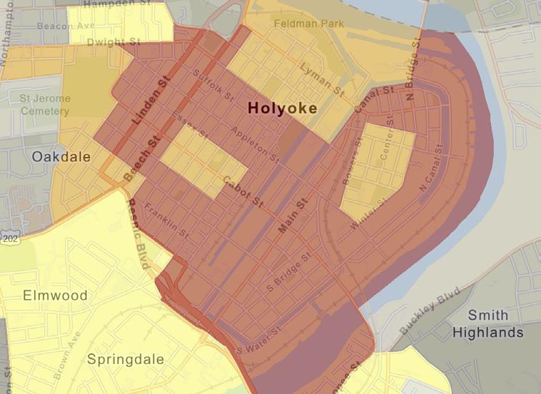
Massachusetts’ Executive Office of Energy and Environmental Affairs (EEA) uses demographic criteria based on minority, income, and English isolation to determine a community’s potential susceptibility to environmental injustice. Identified communities are called “EJ populations.” According to Massachusetts’ Department of Environmental Protection (MassDEP), the project site lies in an EJ population, meeting all criteria.
Holyoke EJ Populations
Environmental Protection Agency Ejscreen Tool
The U.S. Environmental Protection Agency’s (EPA’s) EJScreen tool provides a regularly updated dataset of environmental justice maps. The project site falls within the 80 to 100 percentile range for high exposure to many different types of the EJScreen tool’s environmental indicators such as potential exposure to hazardous waste and proximity to traffic. According to the EPA, while EJScreen data has limitations and should not be interpreted as giving a precise risk assessment, the data is useful for understanding the scope of potential environmental injustices in a community.
Redlining
U.S. federal government redlining maps created from 1935 to 1940 color coded neighborhoods–using a system largely based off of their racial, ethnic, and class makeup–to designate neighborhoods deemed eligible for government home loans (Nelson). The maps were a part of discriminatory government housing policies. A 1937 redlining map for Holyoke shows the project site between two neighborhoods marked in red. Neighborhoods colored in red, and their nearby communities, were categorized as “hazardous.” The description of Holyoke’s redlining map says that the red areas were “peopled by lower class of mill workers and W.P.A. beneficiaries, many of them of foreign descent and uneducated.” The hazardous grade made it “difficult or impossible for people in certain areas to access mortgage financing and thus become homeowners” (Nelson). These neighborhoods were denied government resource investment, which has had “long-term effects in creating wealth inequalities” (Nelson).
Social Inequities And Blight Conditions
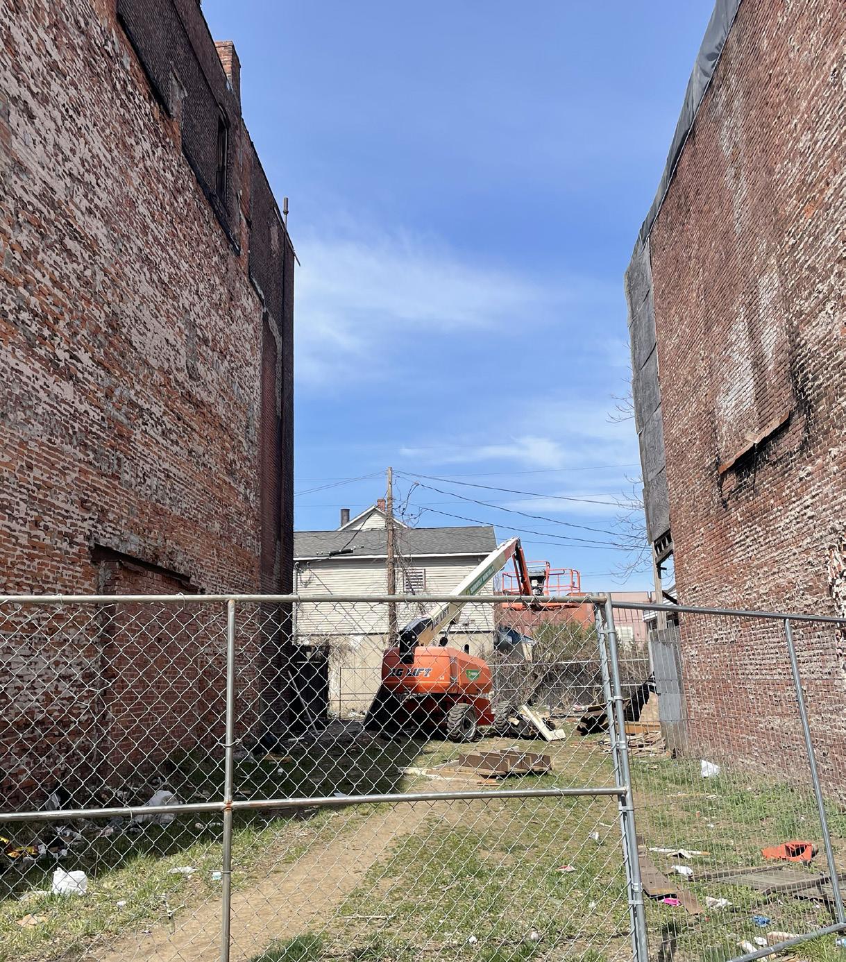
During engagement sessions held in May 2023 for this project the community expressed the ways in which social inequity and blight are present within the neighborhood. The most common inequities reported include houselessness, drug activity, unaffordable housing, harassment and racial discrimination, economic disinvestment through extensive loss of businesses, and a lack of youth programs. The community also shared interest in developing better relationships with the Holyoke police and more patrolling of the neighborhood to help reduce crime. The blight conditions mentioned were the project area’s many empty lots and vacant buildings, and observed litter.
Lack Of Public Amenities
There are almost no street benches or public trash cans, which may contribute to some litter observed within the site.
Holyoke Redlining


Designed By: Eva Hogue & Bindu Nicholson
ENTERTAINMENT, CULTURAL ENRICHMENT, AND FOOD
There is a flourishing social scene within the project site that reflects the rich Puerto Rican culture within the area. During community engagement sessions in May 2023, the community shared that people visit Thursdays through Sundays to gather along the block of Main Street, between Cabot Street and Betty Medina Street. Festivities often go late into the night. Many people, mostly adults, come from nearby neighborhoods and cities and as far as Connecticut. People arrive at the site by car and some ride on their modified and well-cared for motorcycles and three-wheeled cars.
Many people can be found hanging out in the municipal parking lot, setting up chairs to socialize, people watch, and listen to music. People frequent the two bars within the project site, Cayey Social Club and Ekko Bar and Lounge. Visitors spend time at Fiesta Cafe, a family-friendly restaurant with live music and Puerto Rican food that hosts different events such as salsa dancing and their Sunday Day Party where they often roast pigs. Additionally, during the week the municipal parking lot has a pop-up hot dog stand that many people go to for lunch.
Community Resources And Services
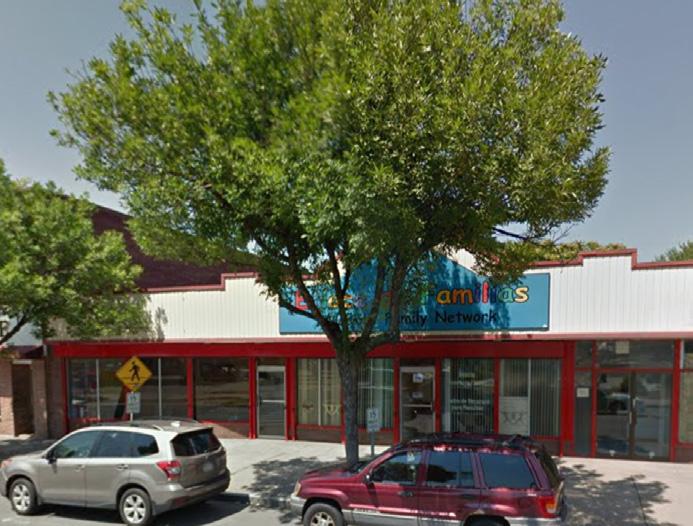
During the weekday visitors primarily come to the neighborhood for the abundant community resources provided by organizations within the area. Some of the community organizations, several with roots back to the early 70’s, 80’s, and 90’s, include: Tapestry Health, a community health clinic; Nueva Esperanza, a community development organization that provides a variety of programs for Latinx residents and businesses; Enlace De Familias, a grassroots non-profit organization that provides food pantry, childcare, adult education classes, and other programming and resources for communities and families; and Nuestras Raíces, a grassroots organization that supports urban agriculture. Additionally, the STEAM building along Race Street which contains many businesses, is home to LightHouse Holyoke, a private school that provides education to 6th to 12th grade students who do not typically thrive in standard public education settings.
Other popular businesses and organizations that people patronize include Racing Mart Fuel gas station, Templo Ebenezer, De La Rosa Funeral Home, and Who’s Next Barbershop. The core client team shared that the funeral home sometimes uses the municipal parking as extra space during services.

Designed By: Eva Hogue & Bindu Nicholson Spring 2023
COMMUNITY FEEDBACK AND CONCERNS: HOW THE COMMUNITY WANTS TO USE THE SITE
During community engagement sessions, community members shared visions for the future of how the project site is used, as well as spaces they would like to see improvements.


Ideas included interest in kioskos (kiosks) and foodtrucks, more park spaces, gardens, places to exercise, areas to sit, water sprinklers, a stage for the parking lot, more trash cans, and adding more murals. Enlace de Familias has expressed interest in an outdoor space for different group activities that they already hold inside of their building, such as cooking classes or after school daycare.
Some community members shared displeasure with late night happenings, loud motors and music that occur in the area. It was expressed that a parking lot, specifically for motorcyclists, could help concentrate louder activity off of Main Street. Two areas were also noted as “feeling unsafe” for children and uncomfortable for many adults: the alleyway between Race and Main Streets, as well as Soucey Park. According to some community members Soucey Park’s primary users are adults instead of children and there is observed drug activity. A few community members suggested that Soucey Park should be locked up at night. Many community members said they were interested in more family friendly and quieter spaces.
Empty Lots And Other Open Spaces
Most of the empty lots, both public and privately owned, are unused by the community. There is one lot along Main Street that is sometimes used as an outdoor church. Additionally, according to the 2020 Holyoke Main Street Corridor Survey, the wide intersection where Clemente and Crescent Street intersect was historically a park, but once it became more industrialized it was paved over (Violette, 2020). Lastly, along Cabot Street, at the southeast edge of the project site (off of the project site boundary) is a community garden run by Nuestras Raices.

