
17 minute read
THE STORY OF COOLEY BROOK IN BLISS AND LAUREL PARKS

The 1.5-mile stream has a long history of human use and modification, with both cultural and ecological implications of past land use on its modern-day functions and uses.
2020
enhancIng ecology In the heart of longmeadoW
Two Visions for Bliss and Laurel Parks
By Cara Montague and Shaine Meulmester
Longmeadow Citizens to Save Our Parks (LCSOP) contracted the Conway School in 2020 to develop design concepts with the goal of improving the ecological health and functioning of Bliss and Laurel Parks while meeting the recreational needs of park visitors.
2020 rePort summary
• Montague and Muelmester’s two design alternatives, Protect the Pond and Natural Processes, explored different approaches to the design and maintenance of the former waterworks and Laurel Pond.
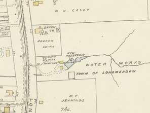
Population growth spurs the construction of waterworks to supply drinking water
Olmsted Brothers design and construct Laurel Pond and dam

Numerous native groups share the Connecticut Valley, including Nonotucks, Agawams, Woronocos, and other indigenous tribes.
The Town purchases 81 acres from Scott Cooley to protect the health of the watershed surrounding the reservoir.
Longmeadow votes to join Springfield’s water system and the waterworks are abandoned and reservoir used as the town swim hole called “The Pump.”
Town stormwater system is completed, directing runoff from surrounding neighborhoods directly into Cooley Brook and eliminating the need for “The Pump”as a swim destination
• Protect the Pond explored preserving the pond while mitigating stormwater runoff and improving water quality through increased pond maintenance.
• Natural Processes explored allowing natural stream processes to shape the landscape. The pond slowly becomes marsh and the waterworks is revived as a recreational space.
• Neither design alternative explored dam removal.
• This document highlighted the need to continue research, community engagement, and planning to revitalize Cooley Brook.
Today
The needs and functions of Cooley Brook are once again changing.
This 2023 report is part of a series of projects that will study, assess, design, and apply bioengineering solutions to improve the Cooley Brook and its watershed as a stormwater management resource, natural stream system, and recreational resource.
2022-2023: The Town hires Tighe & Bond with Community Preservation Act (CPA) funding to complete a Hydraulics, Hydrology & Geomorphic Study on Cooley Brook.
2023: Tighe & Bond produces a 40% green stormwater infrastructure design (GSI) for Bliss Park and Blueberry Hill Elementary School funded through the American Rescue Plan Act (ARPA).
Fall 2023 - 2025: In 2023, the town applied for a Municipal Vulnerability Plan (MVP) grant and a Long Island Sound Futures Fund (LISFF) grant that, if awarded, will be implemented over the next few years.
• MVP will fund alternatives analysis and 60% design for restoration of Cooley Brook within the parks, advancement of GSI in the watershed to 60% design, identify watershed areas for GSI based on needs identified in modeling, and an H&H and reference reach study for the brook downstream of the parks.
• LISFF will fund an EPA 9-Element Watershed Based Plan for the Cooley Brook drainage area; design and implement a resident outreach campaign concerning Low Impact Development (LID) and GSI in yards, prioritize up to 10 locations for GSI retrofits within municipal rights-of-way within the Cooley Brook watershed; and work with DPW to develop standardized design details for GSI systems that they are comfortable maintaining and implementing.
Stream Infrastructure
The human-made infrastructure in Laurel and Bliss Parks alters and partially defines the brook’s character. Traveling upstream, there is a culvert under Longmeadow Street, the old waterworks dam, Laurel Pond dam, the culvert under Laurel Street, and the stormwater pipes at the brook’s headwaters. Because of the infrastructure and nearby development, it is highly unlikely Cooley Brook’s flow patterns could be allowed to return to completely natural processes. Instead, the question is how to maximize ecological integrity within the stream system while still supporting human uses in the watershed. These sketches represent the scale of infrastructure alteration to the landscape, and are drawn to scale horizontally with a 2x exaggeration on the vertical scale.


SUMMARY OF THE HYDROLOGY & HYDRAULICS STUDY


The Hydrology & Hydraulics study concluded that dam removal is feasible based on the stream dynamics, and that the dams do not contribute enough stormwater mitigation to protect the area from flooding. Additionally, the study illustrated the poor ecological health of the system, which should be addressed in the parks and upstream to restore ecological integrity.
The Environmental Engineering firm Tighe & Bond released a Hydrologic and Hydraulic Study of Bliss & Laurel Parks in April 2023. In this study, the authors created hydrologic (amounts of water) and hydraulic (how the water flows) models for existing conditions of Cooley Brook in Bliss and Laurel Parks, and created the same models for the system with both dams removed. Part of the study also assessed the erosion and bank failures along the brook, using existing erosion levels to predict how much of the banks could be eroded. The goal of this study was to understand the current conditions of Cooley Brook, how much the dams contribute to slowing stormwater, and what effect potential dam removal would have on the flow dynamics of the stream system. Below are the main findings of this report:
• Neither Laurel Dam nor the waterworks dam store significant quantities of floodwater. During normal conditions water flows over the dams, meaning that during storms, the reservoirs behind the dams have no volume for flood storage (Figure 1).
• With or without removal of the two dams, a 100-year storm (a storm with a recurrence interval of 100 years, which has a 1% chance of occurring on any given year) will overflow onto Laurel and Longmeadow Streets.
• The culverts under Laurel and Longmeadow Streets (combined with the landforms) do provide flood storage because they are undersized: they are too small for the amount of water flowing into them (Figure 2).

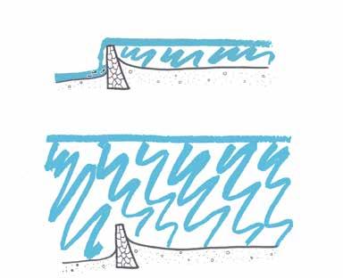
• Because they are undersized, the culverts are at risk of failure (Figure 2).
• The brook’s erosive power has the potential to remove 690 tons of sediment from the stream banks every year, and the dams then trap most of that sediment. That weight is roughly equivalent to the weight of ten blue whales being deposited behind the dams every year (Figure 3).

• Interventions such as green stormwater infrastructure (GSI) are needed in the watershed to slow and clean water before it enters the brook and to decrease the amount of water entering the culverts.
• Dam removal would improve the ecological health of the stream by increasing habitat connection. This would also increase floodplain connectivity which would help provide flood storage.
In conclusion, this study determined that the existing conditions contribute to poor ecological health and a large imbalance of sediment transport. The dams are currently not maintained, suggesting that a plan for moving forward with this system should include either routine maintenance (repairs to the dams and dredging of sediments putting pressure on the dams) or the dams should be removed. This study suggests that the second course of action is not only feasible but would contribute numerous benefits to the Cooley Brook system, including increasing the ecological integrity of the system, addressing the sediment transport imbalance, and allowing for floodplain reconnection that would increase flood storage potential.
This study also highlights the role of culverts in this system and the flood storage they help provide. Because the culverts are undersized for the amount of stream flow, when more water needs to get through the culvert than can fit, it backs up behind the culvert. However, though this backwater effect slows the movement of stormwater, it negatively impacts the health of the culvert. These effects can already be seen at the inlet and outlet of the Laurel Street culvert through localized erosion and scouring. If the culverts were to fail or blow out, according to the Tighe & Bond engineers, it could cause catastrophic damage to the streets and completely alter how the stream flows.
Longmeadow relies upon Cooley Brook for stormwater management due to the limited ability to slow and infiltrate stormwater in the developed watershed (see sheet 7), but since both dams currently have water flowing over them at all times, the dams have little ability to manage water. The study also showed that this system is experiencing a higher amount of sediment being added to the system than is healthy. The variability of stream flows contributes to the high levels of erosion. In order to manage the variability of stream flows, the large volume of stormwater entering the system, and the excessive amount of sediment being eroded, Tighe & Bond recognizes that interventions are needed higher up in the watershed, and have begun the research and design process for green stormwater infrastructure interventions (see sheet 4).
According to the Tighe & Bond engineers, removing the dams will not cause immediate negative impacts to the hydrology or hydraulics. Since stream systems are highly dynamic, Tighe & Bond recommends that if the dams are removed that they be replaced by bioengineering structures, to help provide grade control and floodplain connectivity in the system. In all, this Hydrology & Hydraulics study demonstrates the need for intervention to improve the stability and resiliency of the Cooley Brook system.
Land Cover In The Cooley Brook Watershed
The high amount of developed land and impervious surface cover in the watershed increases the amount of runoff entering Cooley Brook and negatively affects its water quality.
Using Longmeadow Street as the outflow location for the Hydrology & Hydraulics Study, Tighe & Bond calculated that 412 acres drain into Cooley Brook upstream of the Longmeadow Street culvert. Suburban housing developments cover most of the watershed, and were broadly completed by the 1970s (Montague & Meulmester, 2). The development led to alterations of the watershed’s soils, drainage patterns, and land cover. Today, impervious surfaces such as roofs, roads, and sidewalks cover 50.5% of the watershed (NOAA). Though forest is reported to cover the other half of the watershed, this reflects a limitation of the NOAA data set, which does not distinguish between one tree in a turf yard and a block of trees. Bliss and Laurel Parks contribute the most notable contiguous sections of forest in the watershed, with impervious cover limited to the active recreation areas of Bliss Park.
maJor land cover tyPes In the cooley Brook Watershed
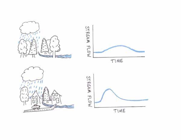
Stream systems begin to experience degradation of habitat and water quality when their watersheds have 10% impervious surface cover, and when they exceed 25% impervious surface cover, the habitat and water quality of a stream system can be severely impaired, especially when runoff goes straight from impervious surfaces to a water body (New Hampshire Estuaries Project). Since water cannot infiltrate into the soil when impervious surfaces cover the ground, that water flows across the surface and concentrates in channels. This causes stream volumes to dramatically increase during storms and move through the system quickly, instead of water slowly being added to the base flow over a longer period of time. This fast-moving, higher volume of water has much more power to erode the stream banks. Also, water draining off impervious surfaces is much more likely to carry pollutants from roadways or built environments, in turn decreasing water quality and affecting aquatic health. These effects of high impervious surface cover in the watershed are evident in Cooley Brook with its steeply eroded banks, algal blooms, and poor aquatic habitat (Barry).
The same amount of water falling on a developed area will flash through the stream system much faster than a forested area, where the vegetation and non-compacted soils slow the movement of runoff and release it more slowly and at a more steady rate into the stream.
Highly manicured lawns that rely on frequent pesticide application are the norm in the neighborhood, but are not reflected in the NOAA Land Cover data set. Lawn does a poor job of infiltrating stormwater, and lawn fertilizers are common pollutants of streams.


Evergreen Forest
Deciduous Forest
Surficial Geology And Soils
The soils of the watershed have little ability to infiltrate stormwater and shed it into Cooley Brook. Conversely, the soils of the parks have high infiltration capacity but are highly erodible.

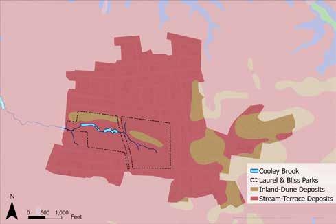

The soils of Cooley Brook’s watershed also reflect the high level of development and alteration of the landscape. The entire watershed shares similar underlying geologic characteristics: Mesozoic sedimentary rock forms the bedrock, which is overlain by surficial deposits of well-sorted sand, associated with the shores of Glacial Lake Hitchcock, which covered the present-day Connecticut River valley. Though there are two types of surficial deposits listed by the USGS for the watershed (stream-terrace deposits and inland-dune deposits), both deposits are made up of well-sorted sand and tend to form similar soils.
Though the entire watershed has sandy surficial deposits, the soils overlying them mostly do not reflect those characteristics. Typically, water moves quickly through soils formed in sand deposits, making them well-draining and causing low runoff potential since runoff easily infiltrates. Because Laurel and Bliss parks have had legal protections since the early 1900s and have experienced little development, the soils of the parks reflect that sandy character. However, completely encircling the parks, the soil characteristics change, reflecting the level of impervious development in the surrounding area. Fill, or supplemental soil from a different location, is often brought in during the construction process. The urban fill complex used in most of the development of this area has high clay content, which creates soils that are poorly drained and when saturated have high runoff potential (MassGIS). Some of the urban fill has no drainage characteristic listed on the MassGIS soil map. Soils with high clay content have little ability to infiltrate runoff and instead runoff flows over the surface before entering a stream channel or storm drain. Since Cooley Brook’s watershed is 51% impervious, and the soils have high runoff potential outside of the parks, most of the stormwater cannot infiltrate and is carried into Cooley Brook. Before stormwater pipes directed more water into this system, the drainage area would have been much smaller and the soils would have been dominantly sandy. Development of the watershed forced Cooley Brook to accommodate much larger quantities of stormwater. Sand particles do not hold together as well as clay particles do, meaning sand is easier to erode than clay. Since Cooley Brook’s banks are made up of sand, this suggests that the Cooley Brook stream channel frequently shifts and experiences high levels of erosion. In other parts of the brook like zones 3 and 4 on sheet 2, riprap hardens the channel to stop it from naturally shifting. Compounding on the higher natural erosion potential of the soils, the alteration of the watershed also increases erosion potential by increasing the amount and speed of stormwater entering the brook.
Drainage
A century of development has increased the quantity and velocity of water entering Cooley Brook, making watershed-scale interventions to capture, store and infiltrate stormwater necessary to balance the processes of erosion and deposition in the stream channel.
Completed in 1970, the Longmeadow municipal stormwater system collects water from 237 acres of impervious surfaces and carries it directly into Cooley Brook at nine storm drain outfalls. The development in effect increased the area of the brook’s watershed beyond what the natural topography produced. Development in the neighborhoods surrounding the parks has greatly altered the hydrology of the watershed. In its existing condition, water sheds off houses, lawns, driveways, and roads into 482 catch basins, then through just over 61,000 feet of drain lines. The storm drain system divides the watershed into ten subbasins on 465 acres (Longmeadow GIS).
Blueberry Hill Elementary School, though not part of the watershed, experiences regular flooding in its parking lots. Currently, the stormwater system servicing the school and several residential streets surrounding it daylight stormwater into an intermittent stream branch of Longmeadow Brook to the south. Due to the regular flooding of the school, the Town is considering adding an overflow drain that would transport floodwater into Cooley Brook during heavy rain events. This would increase the quantity and velocity of water entering the brook only during intense rain events, which would put additional pressure on the already stressed system. Engineering a stormwater overflow at Blueberry Hill Elementary School would mean capturing water through an additional 59 catch basins and 8,276.5 linear feet of stormwater pipe over an additional 53.9 acres of land (Longmeadow GIS). If the quantity of water entering the stream were greatly reduced throughout the watershed, for example, by increasing infiltration in the heavily developed neighborhoods, the Blueberry Hill Elementary School overflow may be a reasonable solution to the flooding taking place. Otherwise, adding overflow drainage will perpetuate the problems of water quality and quantity in Cooley Brook. The municipal storm system creates a challenge to achieving a stable and resilient stream channel. Without watershed-scale planning for stormwater infiltration, the processes of erosion and sedimentation will remain out of balance and efforts to stabilize the stream channel may be jeopardized by intense storms and flooding. The Town is already pursuing design plans to alleviate stormwater infiltration and retention with the Resilient Stormwater
Project. Tighe & Bond is identifying green stormwater infrastructure (GSI) interventions in concert with stream restoration for Cooley Brook. This multiscalar approach has the goal of discovering the best solutions to handling hydromodifications in the watershed and achieving stability in Cooley Brook.

Flooding in Bliss Park
A two-inch rainstorm in May 2023 caused notable flooding in Bliss Park. The paths, basketball court, and playground were inundated with stormwater. Though there are several stormwater catch basins in the park, topographical low areas and compacted soil cause pooling that affects the most heavily-used spaces in the park.
Improving stormwater conveyance and increasing infiltration of runoff will reduce the impact flooding has on park features and benefit Cooley Brook by reducing the quantity and velocity of runoff. Existing stormwater drains present an opportunity for siting infiltration basins with overflow drains connecting to existing infrastructure.
hydromodIfIcatIon In the cooley Brook Watershed
Hydromodification is the alteration of hydrological characteristics of a waterway or watershed (U.S. EPA, 2007). Changes in the timing and volume of runoff from a site are known as “hydrograph modification” or “hydromodification,” occurring when an area is developed; increased impervious surfaces, stream channelization and alteration, and dam construction are a few processes that alter the hydrological characteristics of a waterway. Hydromodification can cause the degradation of water resources, though the term is not reserved for negative outcomes. Threshold design—a traditional stream restoration strategy that uses erosion-resistant materials like rocks or grass liners to keep the stream within one rigid channel—can also be considered hydromodification.
From the development of the Longmeadow Waterworks in the late nineteenth century to the completion of the town storm sewer in the late twentieth century, the Cooley Brook and its watershed have experienced over a century of hydromodification at the hands of its human inhabitants to meet the needs of a growing community. The storm drain system increases the watershed area, and impervious surfaces increase the velocity and quantity of runoff entering Cooley Brook beyond what would occur in the watershed’s predeveloped, vegetated state, where the forests and sandy soils would slow and infiltrate stormwater before entering the stream.
ACTIVE RIVER AREA & SLOPES


Planning for the future of the Cooley Brook system must include consideration of human activities that occur within the active river area and allow for potential changes to stream flow dynamics. The future of this stream system, without intervention, will include more erosion because of the steep slopes. One option for intervention is to harden the channel by reinforcing the slopes with rock or some other mechanism which would force the brook to maintain one flow regime. Hardening the channel and banks would decrease risk to humanbuilt structures, but would alter and potentially decrease ecological health. Rivers constitute more than just the area where water flows on any given day. All areas likely to flood during the 100-year flood event make up the active river area. This area includes the stream channel, stream banks, terraces, floodplains, and slopes providing sediment necessary for stream processes. The active river area also reflects stream channel migration: since rivers are dynamic and flow patterns change, rivers need to be able to modify where the stream channel flows on the landscape over time. Because stream channel migration typically happens over a long period of time and full inundation of the active river area happens infrequently, permanent structures are often built within the active river area and are at risk of damage.
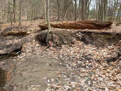
Part of the active river area are the slopes that provide sediment for stream processes. Balanced river systems create terraces that fill up with increasingly large storm events. The slopes of Cooley Brook exhibit this terracing effect in some locations, namely the areas where forest has remained intact over the centuries and where dams have caused the slowing of water. However, slopes of the brook’s banks are excessively steep (compared to the broadly flat watershed) contributing to the loss of the terrace landform. Much of the brook’s excessively steep slopes are greater than the angle of repose, the slope that can be maintained based on gravity and the type of material. Having a slope steeper than the angle of repose suggests that this material is not stable and is easily mobilized by water, wind, or gravity itself. The steep slopes of the banks reflect the power of water in Cooley Brook to incise, or cut down, the stream channel. In stream systems with highly erodible banks, incised channels are common, but are not stable and are susceptible to mass wasting events like a bank collapsing into the brook. This reflects the highly dynamic nature of stream systems within their active river areas. Though this is a natural process, because this system is in a highly developed area, the brook has less ability to naturally rework its channel without impacting human uses.

stream channel bankfull (2-year flood event) active river area (100-year flood event) outside the active river area


1’ = 30’
2x vertical
sloPes of laurel & BlIss Parks sloPes greater than the angle of rePose
B’ B B’ B
stormWater Increases the sedIment load
Sediment Transport
Dams and stormwater pipes significantly alter the flow dynamics of Cooley Brook in different ways, affecting how sediment moves through the stream system. Erosion (sediment loss) and deposition (sediment gain) are natural stream processes that occur evenly along a stream profile in a stable stream system. Dams interrupt these natural processes, concentrating and separating erosion and deposition to different areas of the stream system.
The steep slopes of the Cooley Brook system do provide sediment for stream processes but the presence of dams in the system highly alters sediment transport processes. Minor changes in flow dynamics and stream channel conditions (like the presence of meanders or riffles) contribute to the variability of erosion and deposition across a small distance in a typical stream channel. Once a dam is introduced, it cuts off the transport of sediment beyond its structure and slows the movement of water. This creates a concentrated area of deposition on the upstream side of the dam. Because of the changes to flow dynamics and sediment transport, water moves more quickly farther upstream and immediately downstream of the dam, leading to high levels of erosion in those areas. This process is reflected in the Cooley Brook system, with much of the erosion being concentrated in Bliss Park and the deposition being concentrated behind the dams in Laurel Park. The Tighe & Bond geomorphic study predicted the potential for 690 tons of sediment to be eroded from the banks of Cooley Brook every year, which is roughly equivalent to the weight of ten blue whales.

Flow Direction
Erosion (sediment loss)
Deposition (sediment gain)

Unaltered Stream Channel Stream Channel with Dams
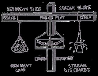
Stream sediment loads depend on the channel dimension, sediment size, and stream slope, and are always proportional to the stream discharge.


Phase 1: Before the addition of stormwater pipes in the Cooley Brook system, the processes of erosion and deposition are in balance and the sediment load carried by the water is proportional to the amount of water carried by the stream over time. In this system, the sediment size is coarse, reflecting the sandy soils, and the slopes are steep in response to the sediment characteristics.
Phase 2: After stormwater drains bring larger volumes of water into the stream, the system is thrown out of balance and high levels of erosion occur.
Phase 3: In order to return to balance, the amount of sediment carried by the stream must increase. Erosion and deposition once again balance each other out, but more sediment and more water now move through the system. Because of the presence of the dams, erosion and deposition are concentrated in different areas of the brook.


