Hertsmere Borough Council
Hertsmere Local Plan Draft Regulation 18 Consultation Document
Radlett Area Sites
Hertsmere Borough Council
Hertsmere Local Plan Draft Regulation 18 Consultation Document
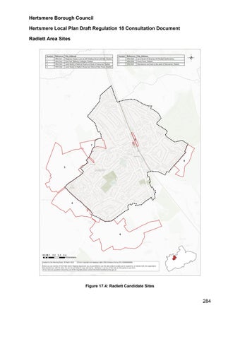
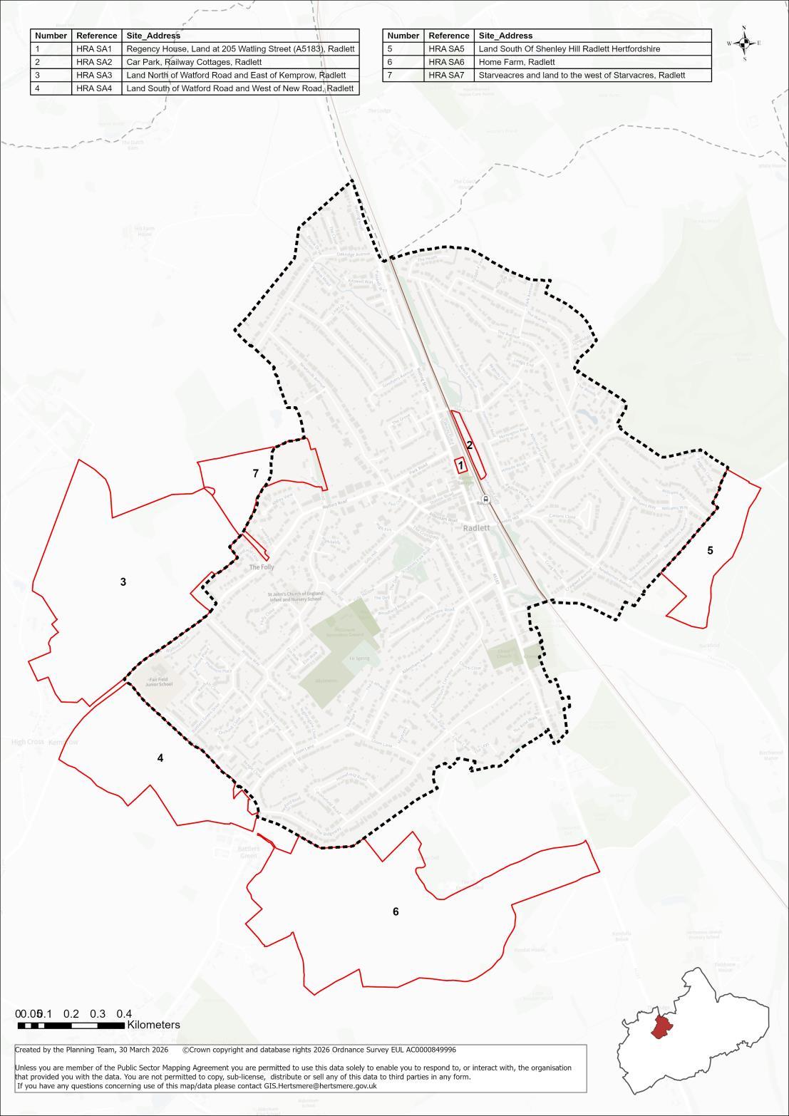
List of candidate sites:
HRA SA1 Regency House, Land at 205 Watling Street (A5183), Radlett
HRA SA2 Car Park, Railway Cottages, Radlett
HRA SA3 Land North of Watford Road and East of Kemprow, Radlett
HRA SA4 Land South of Watford Road and West of New Road, Radlett
HRA SA5 Land South of Shenley Hill, Radlett
HRA SA6 Home Farm, Radlett
HRA SA7 Starveacres and land to the west of Starvacres, Radlett
Hertsmere Borough Council
Hertsmere Local Plan Draft Regulation 18 Consultation Document
HRA SA1, Regency House, Land at 205 Watling Street (A5183), Radlett
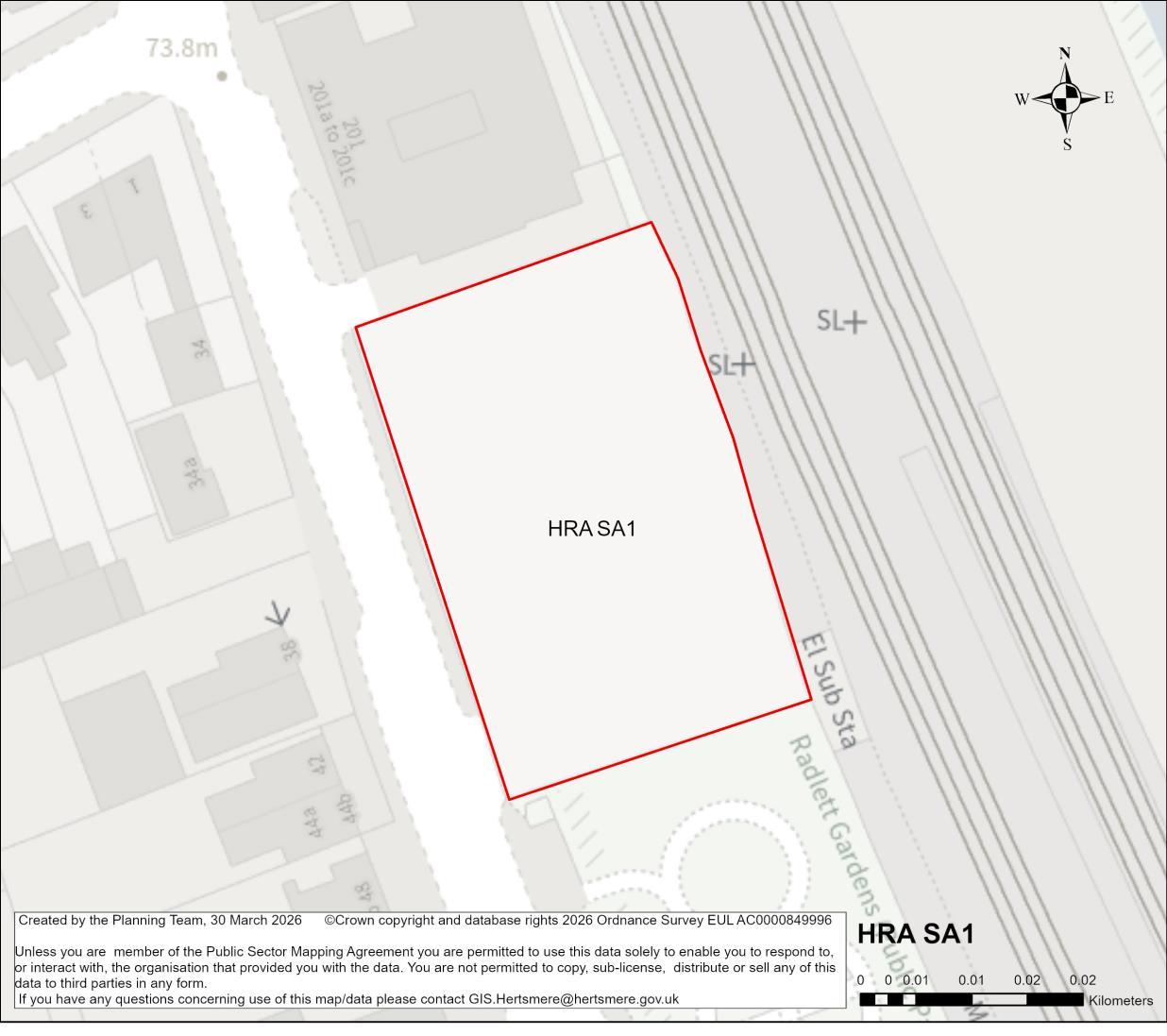
Site Address Regency House, Land at 205 Watling Street (A5183), Radlett
Site Details Vacant site located within the Radlett town centre, where development has resulted in the excavation of the site following the removal of the petrol station. However, works on the extant permission have not progressed beyond excavation.
Site Characteristics
Planning Designations and Site Considerations
Site Size ha 0.19 Setting Central urban Ownership Private Current Use Vacant
Urban Site; Comprehensive redevelopment comprised of residential uses (with vertical intensification).
Site adjacent to Radlett North Conservation Area (west) and railway line (east). Potential ground contamination on the site.
Planning Status 18/0479/FUL: Demolition of existing building (Regency House) and removal of existing petrol filling station (Radlett Service Station). Erection of a part 3/ part 4 storey building to provide offices (Class B1) and ancillary flexible co-working,
Hertsmere Local Plan Draft Regulation 18 Consultation Document
retail, communal and/ or leisure uses on the ground floor (classes A1, A2, B1, D1 or D2) with two levels of basement car parking, cycle parking, refuse storage and public realm improvements.
Development commenced following the demolition of the petrol station, and therefore permission remains extant.
Extant permission does not include residential development. The Council considers that the site could deliver residential properties and the
A comprehensive redevelopment is proposed, which will contribute towards wider town centre regeneration and make more efficient use of this sustainable location, and will primarily comprise of residential uses. The regeneration of this central urban site will secure walking and cycling routes, as well as public realm and environmental enhancements.
The development of the candidate site provides an opportunity to secure high-quality townscape and built form that will ensure that this area contributes positively to the Radlett’s area needs. The delivery of a higher intensity residential accommodation aligns with the spatial strategy proposed for the Borough.
Developers will be required to prepare comprehensive proposals that deliver the mix and at least the quantum of development specified in the site allocation policy. As an urban site set in a prominent and sensitive location, future proposals must be supported by masterplans, and design codes (if multiple phases are required) evidencing inclusive design. Landowners will be required to demonstrate that they are working positively in partnership to deliver development across the site.
Hertsmere Borough Council
Hertsmere Local Plan Draft Regulation 18 Consultation Document
HRA SA2, Car Park, Railway Cottages, Radlett
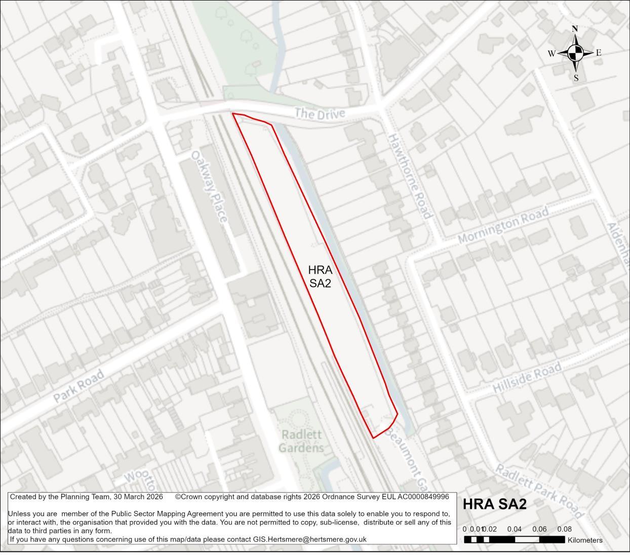
Site Address Car Park, Railway Cottages, Radlett
Site Details Car park site located to the east of the railway line. The site is surrounded by mature vegetation on the boundary and in proximity to two-storey residential properties.
Site Characteristics Site Size ha 0.74 Setting Central urban Ownership Private Current Use Car park
Planning Designations and Site Considerations
Urban Site; Comprehensive redevelopment comprised of residential uses (with vertical intensification).
Site situated and partially covered by Flood Zones 2 and 3. No other constraints.
Planning Status No recent relevant planning history.
Timeframe for Delivery Years 1 – 5 Years 6 –10 Years 11 – 15 Beyond 15 Years
A comprehensive redevelopment is proposed, which will contribute towards wider town centre regeneration and make more efficient use of this sustainable location, and will primarily comprise of residential uses. The regeneration of the site will secure walking and cycling routes, as well as public realm and environmental enhancements. The development of the candidate site provides an opportunity to secure high-quality townscape and built form that will ensure that this area contributes positively to the Radlett’s area needs. The delivery of a higher intensity residential accommodation aligns with the spatial strategy proposed for the Borough.
Developers will be required to prepare comprehensive proposals that deliver the mix and at least the quantum of development specified in the site allocation policy. As an urban site set in a sensitive location, future proposals must be supported by masterplans, and design codes (if multiple phases are required) evidencing inclusive design. Landowners will be required to demonstrate that they are working positively in partnership to deliver development across the site.
Hertsmere Borough Council
Hertsmere Local Plan Draft Regulation 18 Consultation Document
HRA SA3, Land North of Watford Road and East of Kemprow, Radlett
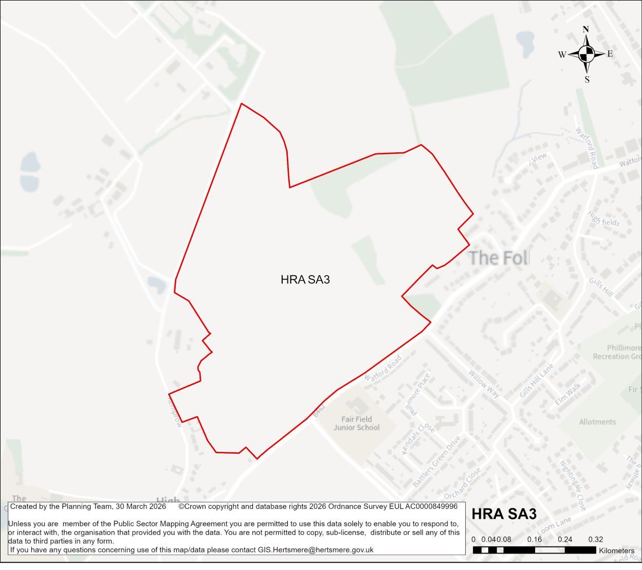
Site Address Land North of Watford Road and East of Kemprow, Radlett
Site Details Undeveloped land situated to the north of Watford Road on the outskirts of Radlett.
Site Characteristics Site Size ha 42.26 Setting Edge of urban area Ownership Private Current Use Agricultural
Planning Designations and Site Considerations
Strategic urban extension; Development comprised of higher density residential and open space uses (inclusive of retained woodland and hedgerows).
Areas of Group Tree Preservation Orders within the site and small area of Local Wildlife Site. Public rights of way crossing the site.
Planning Status No recent relevant planning history.
Timeframe for Delivery Years 1 – 5 Years 6 –10 Years 11 – 15 Beyond 15 Years
Gross Non-Residential Floorspace
To be confirmed – comprehensive redevelopment of the site could include a mix of complementary main town centre, social infrastructure and employment uses (as defined under Class E).
A strategic urban extension is proposed, which would make efficient use of land and contribute to the Borough’s housing delivery targets. The development of this site will secure new and improved transport infrastructure, including walking routes and cycle ways, as well as public realm and environmental enhancements, including new public open space and planting. It is anticipated that the comprehensive development of the site as a new strategic urban extension will incorporate an appropriate mix of main town centre, social infrastructure and employment uses. The scale of non-residential uses will be informed through by the master planning of the site.
The development of the candidate site provides an opportunity to secure high-quality townscape and built form that will ensure that this area contributes positively towards Radlett’s needs. Proposals in this location will deliver comprehensive strategic development, comprised of higher density residential, main town centre uses, social infrastructure and open spaces. The delivery of the above aligns with the spatial strategy proposed for the Borough.
Developers will be required to prepare comprehensive proposals that deliver the mix and at least the quantum of development specified in the site allocation policy. As a strategic site, future proposals must be supported by masterplans, and design codes (if multiple phases are required) evidencing inclusive design. Landowners will be required to demonstrate that they are working positively in partnership to deliver development across the site.
Hertsmere Borough Council
Hertsmere Local Plan Draft Regulation 18 Consultation Document
HRA SA4, Land South of Watford Road and West of New Road, Radlett
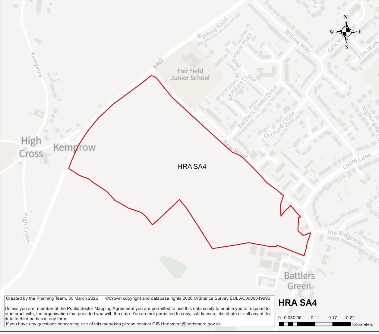
Site Address Land South of Watford Road and West of New Road, Radlett
Site Details Undeveloped land adjacent to residential properties along New Road.
Site Characteristics Site Size ha 19.55 Setting Edge of urban area Ownership Private Current Use Agricultural
Planning Designations and Site Considerations
Urban extension; Development comprised of higher density residential and open space uses (inclusive of retained hedgerows).
The site contains an identified archaeological site. South-eastern corner of the site: development potential impact on the setting of Battlers Green listed buildings (Five Grade II and one Grade II* buildings). Mature trees separating parcels (not protected).
Planning Status No recent relevant planning history.
Borough Council Hertsmere Local Plan Draft Regulation 18 Consultation Document
An urban extension is proposed, which would make efficient use of land and contribute to the Council’s housing delivery targets. The development of this site will secure new and improved transport infrastructure, including walking routes and cycle ways, as well as public realm and environmental enhancements, including new public open space and planting.
The development of the candidate site provides an opportunity to secure high-quality townscape and built form that will ensure that this area contributes positively towards Radlett’s needs. Proposals in this location would seek to deliver comprehensive strategic development, comprised of higher density residential, and open spaces. The delivery of the above aligns with the spatial strategy proposed for the Borough. Developers will be required to prepare comprehensive proposals that deliver the mix and at least the quantum of development specified in the site allocation policy. As a strategic site, future proposals must be supported by masterplans, and design codes (if multiple phases are required) evidencing inclusive design. Landowners will be required to demonstrate that they are working positively in partnership to deliver development across the site.
Hertsmere Borough Council
Hertsmere Local Plan Draft Regulation 18 Consultation Document
HRA SA5, Land South of Shenley Hill, Radlett
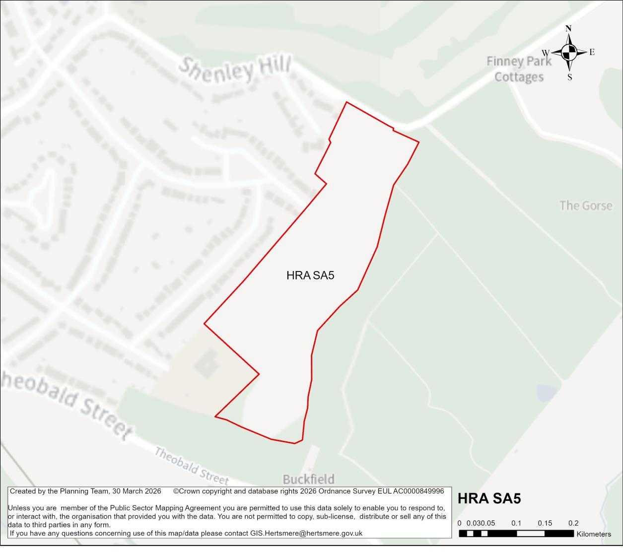
Site Address Land South of Shenley Hill, Radlett
Site Details Undeveloped land
Site Characteristics Site Size ha 8.69 ha Setting Edge of urban area Ownership Private Current Use Agricultural
Planning Designations and Site Considerations
Urban extension; Development comprised of higher density residential and open space uses (inclusive of retained hedgerows).
No planning constraints.
Planning Status 24/1211/OUT: Outline permission (with all matters reserved except for means of access) for the erection of up to 195 new homes (50% affordable), safeguarded land for the expansion of Newberries Primary School and provision of a new medical centre, along with associated access, landscaping and parking.
Hertsmere Borough Council
Hertsmere Local Plan Draft Regulation 18 Consultation Document
Appeal allowed. Decision issued on 23 Mar 2026. Permission expiring on 23 Mar 2029.
Timeframe for Delivery Years 1 – 5 Years 6 –10 Years 11 – 15
Indicative Development Capacity Net Residential Units 195 dwellings
Beyond 15 Years
An urban extension is proposed, which would make efficient use of land and contribute to the Borough’s housing delivery targets. The development of this site will secure new and improved transport infrastructure, including walking routes and cycle ways, as well as public realm and environmental enhancements, including new public open space and planting.
The development of the candidate site provides an opportunity to secure high-quality townscape and built form that will ensure that this area contributes positively towards Radlett’s needs. Proposals in this location would seek to deliver comprehensive strategic development, comprised of higher density residential, and open spaces. The delivery of the above aligns with the spatial strategy proposed for the Borough.
Developers will be required to prepare comprehensive proposals that deliver the mix and at least the quantum of development specified in the site allocation policy. As a strategic site, future proposals must be supported by masterplans, and design codes (if multiple phases are required) evidencing inclusive design. Landowners will be required to demonstrate that they are working positively in partnership to deliver development across the site.
The candidate site has a live consent. It forms part of the Borough’s committed fiveyear housing land supply. The principle of it providing a source of supply that delivers growth is established. On that basis it will become a site allocation.
Hertsmere Borough Council
Hertsmere Local Plan Draft Regulation 18 Consultation Document
As a live consent that contributes towards the Borough’sfive-year housing land supply, the Council considers it reasonable to assume that the site will commence and begin to deliver growth and meet needs in a timely manner47. Consents that fail to deliver and consequently require renewal will in the future be assessed against the new Local Plan. Should that arise, the Council may consider measures that secure greater certainty of timely delivery.
47 To make a meaningful contribution to Housing Delivery performance consented housing schemes must deliver within three years of receiving consent.
Hertsmere Borough Council
Hertsmere Local Plan Draft Regulation 18 Consultation Document
HRA SA6, Home Farm, Radlett
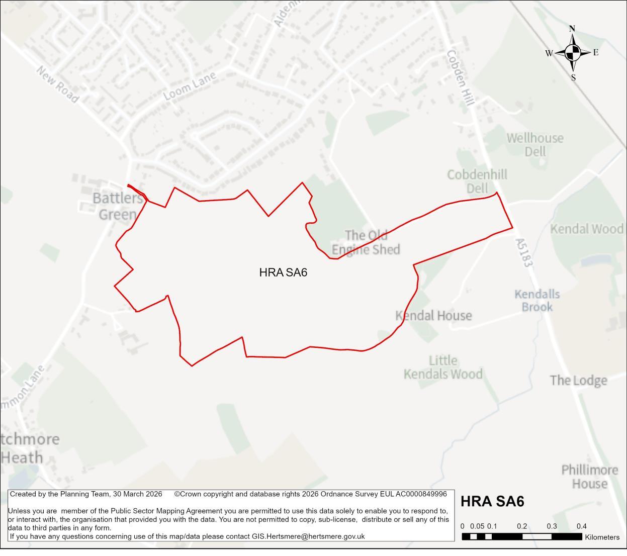
Site Address Home Farm, Radlett
Site Details Undeveloped land
Site Characteristics Site Size ha 45.22 ha Setting Rural Ownership Private Current Use Agricultural
Planning Designations and Site Considerations
Strategic Urban Extension; Comprehensive strategic development, comprised of higher density residential, social/ community infrastructure, open spaces, main town centre uses.
Public rights of way through the site. Development has the potential to impact the setting of Grade II listed Barn and Attached Former Cowhouse at Little Kendalls Farm; as well as four Grade II listed and one Grade II* listed buildings at Battlers Green. Small pockets of surface water flood risk.
Planning Status 25/1456/EI2: scoping request submitted for residential led development, delivering up to 600 residential units, along with compatible supporting non-
Hertsmere Local Plan Draft Regulation 18 Consultation Document
residential uses including a primary school, a range of green infrastructure and open spaces and all associated works.
Timeframe for Delivery Years 1 – 5 Years 6 –10 Years 11 – 15
Indicative Development
Capacity
Beyond 15 Years
Net Residential Units
1040 dwellings
Gross Non-Residential Floorspace
To be confirmed – comprehensive redevelopment of the site could include a mix of complementary main town centre, social infrastructure and employment uses (as defined under Class E).
A strategic urban extension is proposed, which would make efficient use of land and contribute to the Borough’s housing delivery targets. The development of this site will secure new and improved transport infrastructure, including walking routes and cycle ways, as well as public realm and environmental enhancements, including new public open space and planting. It is anticipated that the comprehensive development of the site as a new strategic urban extension will incorporate an appropriate mix of main town centre, social infrastructure and employment uses. The scale of non-residential uses will be informed through by the master planning of the site.
The development of the candidate site provides an opportunity to secure high-quality townscape and built form that will ensure that this area contributes positively towards Radlett’s needs. Proposals in this location would seek to deliver comprehensive strategic development, comprised of higher density residential, and open spaces. The delivery of the above aligns with the spatial strategy proposed for the Borough.
Developers will be required to prepare comprehensive proposals that deliver the mix and at least the quantum of development specified in the site allocation policy. As a strategic site, future proposals must be supported by masterplans, and design codes (if multiple phases are required) evidencing inclusive design. Landowners will be required to demonstrate that they are working positively in partnership to deliver development across the site.
Hertsmere Borough Council
Hertsmere Local Plan Draft Regulation 18 Consultation Document
HRA SA7, Starveacres and Land to the West of Starveacres, Radlett
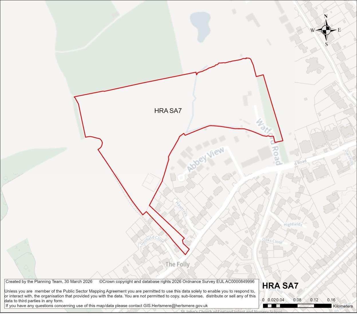
Site Address Starveacres and Land to the West of Starveacres, Radlett
Site Details Single dwelling within large site, safeguarded under previous Local Plan (2013).
Site Characteristics
Planning Designations and Site Considerations
Site Size ha Setting Edge of urban area Ownership Private Current Use Residential
Urban Extension; Development comprised of higher densityresidential and open space uses (inclusive of retained woodland).
No constraints identified.
Planning Status No recent relevant planning history.
Timeframe for Delivery Years 1 – 5 Years 6 –10 Years 11 – 15 Beyond 15 Years
An urban extension is proposed, which would make efficient use of land and contribute to the Council’s housing delivery targets. The development of this site will secure walking routes, as well as public realm and environmental enhancements, including new public open space and planting.
The development of the candidate site provides an opportunity to secure high-quality townscape and built form that will ensure that this area contributes positively towards Radlett’s needs. Proposals in this location would seek to deliver comprehensive development, comprised of higher density residential, and open spaces. The delivery of the above aligns with the spatial strategy proposed for the Borough.
Developers will be required to prepare comprehensive proposals that deliver the mix and at least the quantum of development specified in the site allocation policy. As a strategic site, future proposals must be supported by masterplans, and design codes (if multiple phases are required) evidencing inclusive design. Landowners will be required to demonstrate that they are working positively in partnership to deliver development across the site.
Radlett Candidate Sites Questions:
62. Question: Do you agree with the Council's approach to residential candidatesiteallocationsinandaroundRadlett?Yes/No.
63. Question: Which site do you wish to provide further comments on? [Multiplechoice]
64. Question: If you disagree with any of the content, with reference to specific site codes, please provide detailed comments or suitable alternatives. Please justify your answer with appropriate and proportionateevidence.