Detailed
Housing Allocations
H1 Southeast Billericay
H2 Land West of Great Burstead
H3 Land South of Great Burstead
H4 Land West of Laindon Road
H6 Land Adj to Tye Common Road and South of London Road
H7 Land North of London Road, Billericay
H8 Land West of Bowers Gifford
H10 Land North of A13
H11 Land West of West Mayne
H12 Land Adj to Dunton Road
H13 Land North of London Road, Vange
H15 Land Adj to Nevendon Road
H17 Land Adj to Wick Country Park
H18 Land North of Southend Road, Shotgate
H19 Land Adj to Barn Hall, Wickford
H20 Land North of London Road, Wickford
H21 Land South of London Road, Wickford
H22 Land North of Wash Road
H23 Bowers Gifford Plotland
H24 Land North of Dry Street
H25 Gardiners Lane South
H26 Land East of Noak Bridge
H27 Crays Hill
H28 Land West of Castledon Road
H29 Ramsden Bellhouse
H30 Land West of Noak Hill Road
H31 Land at Mountnessing Road
H32 Potash Road
H33 Land East of Bowers Gifford
Gypsy and Traveller Allocations
GT1 Land South of Harrow Road
Employment Allocations
E1 Burnt Mills
E2 Dunton Bootsale
E3 Land Adjacent to Hovefields Avenue
E4 Land West of Canvey Way
E5 Friern Manor Farm
E6 South of Nevendon Road
E7 South of Fanton Hall Farm
Site Allocations
Our Local Plan presents 42 allocation sites where new housing or employment with essential infrastructure is deemed as deliverable. Each allocation is an underutilised land parcel that merits a specific policy to help shape and unlock significant levels of growth in a manner that responds to the allocation’s context, conforms with our spatial strategy and secures benefits for local residents, such as improved public realm, new schools, health services and job opportunities.
The purpose of site allocation policies is to clearly set out what land uses are suitable, the core principles for development and the design parameters which should be considered by applicants, without being overly prescriptive and impeding creative design solutions to address the allocations’ constraints. The policies provide allocation site-specific guidance for the aspirations we have for each allocation, the contribution they can make to Basildon Borough and Essex County; and provides a certainty to help unlock their potential that may not otherwise come forward.
All other policies in the plan apply to the site allocations in the usual way.
SCALE OF DEVELOPMENT
An approximate number of homes is set out for sites allocated for housing to provide an indication of the scale of development we expect. The actual number of homes and densities provided on each allocation will be subject to the design of a scheme and other planning policies, to be discussed during the pre-application stage for a smooth planning application process. It is important to note that these trajectories include, and are not in addition to, homes that already have consent within the allocated sites.
PROTECTING THE GREEN BELT
Our Green Belt does not just provide a recognisable boundary for Basildon Borough, its vegetation also supports our health and wellbeing, biodiversity and climate resilience. Any proposed release of Green Belt land for a site allocation has been informed by the Local Planning Authority’s assessment of all reasonable alternatives for meeting identified development needs, in line with the NPPF. The spatial strategy has considered brownfield opportunities, existing urban sites, density optimisation, and engagement with neighbouring authorities.
In defining the detailed boundaries of the Green Belt, we have taken care to follow readily recognisable and defensible physical features that are likely to endure, such as streams, hedgerows, footpaths, and highways. Where this is not possible due to site-specific conditions, boundaries have been defined with a clear and logical rationale that can be understood and interpreted on the ground; as well as endure beyond the plan period.
CLIMATE RESILIENCE & BIODIVERSITY ENHANCEMENTS
There is a need to protect our communities and biodiversity from the extreme weather events we now experience due to global warming. The use of green infrastructure or nature-based interventions can help reduce the detrimental impacts that these extreme weather events have on our everyday lives. As such, the applicant will be required to demonstrate a green infrastructure strategy that addresses climate resilience and the multiple benefits of urban planting for delivery of the site allocation. Reference should be made for all sites to the Essex Local Nature Recovery Strategy (LNRS).
H1, Southeast Billericay
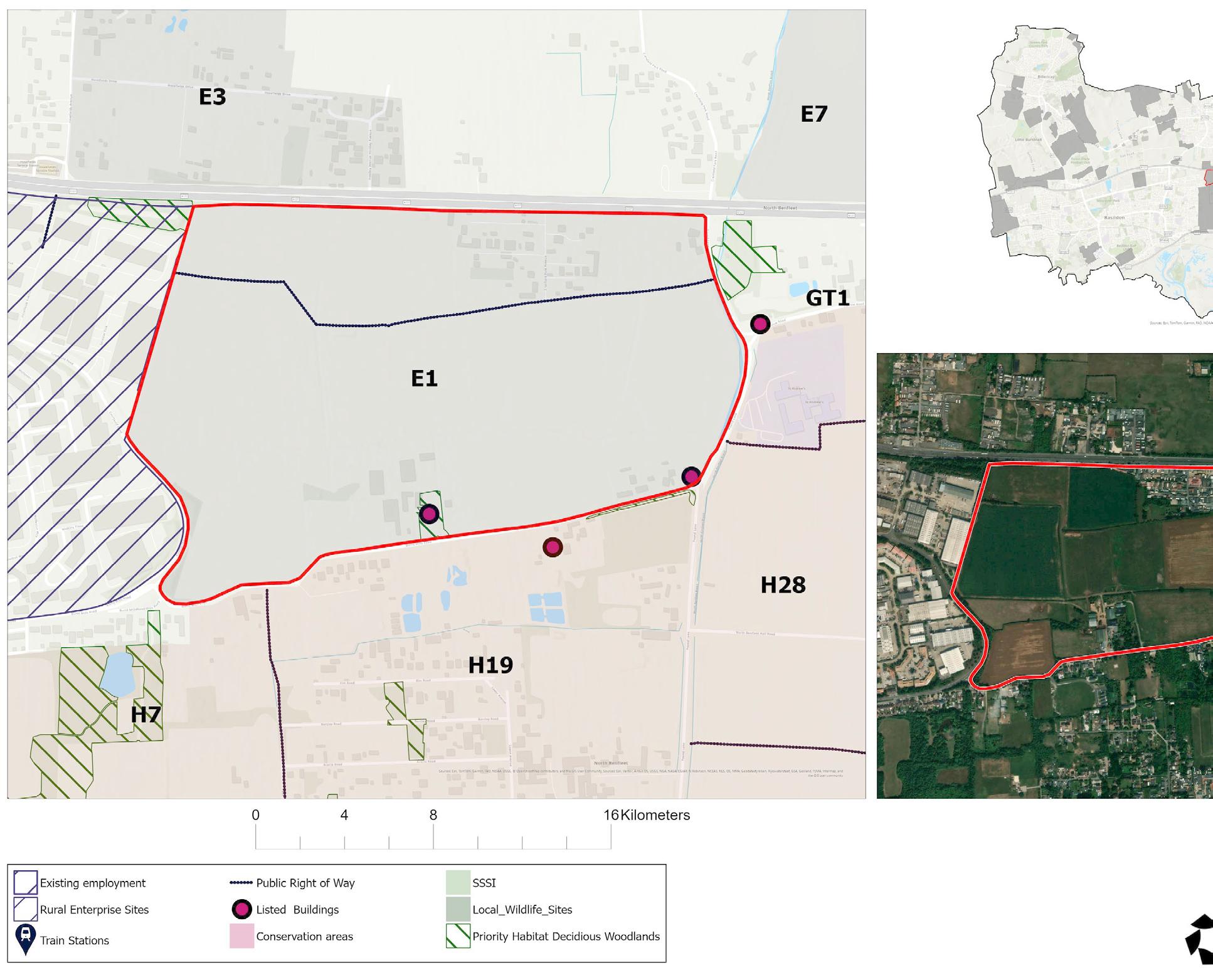

Site allocation context and description of existing
Land to the southeast of Billericay comprises approximately 221 hectares of predominantly agricultural land, interspersed with woodland, mature hedgerows, and pockets of existing residential and industrial development. The site allocation is bounded by the Sunnymede residential area to the north, South Green to the west, open countryside to the east, and Barleylands Farm Park to the south, contributing to its semi-rural character.
The A129 (Southend Road) defines the southern and western edges of the allocation, with minor rural roads providing access elsewhere. St Peter’s Catholic Primary School is located within the allocation, along its western boundary. Mill Meadows SSSI adjoins the allocation at its north-western corner and represents a significant ecological asset.
Figure 1: H1 Location Maps
POLICY H1, Southeast Billericay
Allocation Information Details
Location Great Burstead and South Green
Allocation area (ha) 191.60
Relevant Permissions 23/01147/FULL Land East of South End Road: Demolition of existing buildings and redevelopment of the site to provide 99 residential dwellings (Class C3); provision of strategic landscape; provision of new vehicular and pedestrian access routes and associated infrastructure.
Indicative capacity 2580 – 2750 homes
Indicative net residential density* 45 dph
Phasing 2025-30, 2031-35, 2036-40
* For the purpose of calculating density, the net developable area includes residential plots, local streets, and small incidental open spaces. Larger areas of public open space, green infrastructure, sustainable drainage areas, and primary road corridors are excluded.
VISION
Our vision for Land Southeast of Billericay (H1) is for the delivery of a future proofed urban extension to the east of South Green; incorporating high quality mixed-use development with associated infrastructure that contributes to a sustainable, serviced neighbourhood.
Green infrastructure will be designed into the schemes as a multi-beneficial asset that will engender permeability of this urban extension and provide connectivity between the new development and wider existing neighbourhoods and towns.
CORE PRINCIPLES
Development proposals will come forward as part of a masterplanned approach to the whole allocation that delivers on the following:
1. Provide a varied mix of tenures, housing sizes and building typologies to support a balanced and inclusive community.
2. Arrange the built form and building typologies to support place-shaping and site-wide legibility and to achieve the indicative net residential density across the allocation.
3. Take all reasonable measures to achieve the indicative capacity of the allocation by optimising density
CHAPTER 15: Site Allocations – Housing
within the areas planned for residential development, including by applying efficient and space-optimising house types and layouts where appropriate, while ensuring that required open-space provision is fully delivered.
4. Allow for the phased release of land.
5. Provide for the delivery of key infrastructure.
Sustainability
6. Sustainability is to be at the heart of the proposal, including:
6.1 The design, operation, and adaptability of new buildings, with a focus on reducing both operational and embodied carbon, maximising water efficiency, and incorporating sustainable drainage that responds to the allocation’s topography.
6.2 A holistic approach to green infrastructure that delivers an ecologically rich planting planting strategy across the whole allocation, providing multiple benefits including climate resilience, support for active travel and wayfinding, improved air quality, attractive and safe public spaces for leisure and rest, community garden spaces, and enhancements to local biodiversity.
Infrastructure
7. Provide land for a new primary school with associated early years and childcare provision or required financial contributions to existing local primary
schools to enable the expansion to accommodate demand arising from the development, as required by the Local Education Authority. Any new or expanded provision must meet the requirements set out by the Local Education Authority. All new facilities must be safely and conveniently accessible by inclusive pedestrian and cycle routes that connect with surrounding residential areas.
8. Provide land for new standalone early years and childcare provision, and/or make the required financial contributions to existing early years and childcare provision to enable expansion sufficient to accommodate demand arising from the development, as required by the Local Education Authority. Any new or expanded provision must meet the requirements set out by the Local Education Authority.
9. Provision of a new Local Centre towards the south, where higherdensity housing and community facilities are expected.
10. Provide for the delivery of an integrated primary healthcare hub in conjunction with the Mid and South Essex Integrated Care System.
11. Retain St. Peter’s Catholic Primary’s football pitch and netball courts in accordance with the Playing Pitch and Outdoor Sports Strategy.
12. Provide open space in line with the Open Space Study, ensuring access to high-quality recreational and natural environments. This should include safe, inclusive areas for informal recreation and play and reduce pressure on the Mill Meadows SSSI.
13. A legal agreement will be required
to secure the location and delivery trajectory for Gypsy and Traveller provision, in accordance with HOU4.
14. Development should be phased to ensure timely delivery of infrastructure, movement routes, and public spaces.
15. Development must have essential services (water, electricity, and foul drainage) available on-site or able to be made available on-site. Foul drainage to a public sewer should be provided where possible. Where it is not, evidence will need to be provided showing that suitable alternative facilities can be provided.
Connectivity
16. Maximise connectivity between parcels and avoid single-access layouts wherever practicable. Where a single-access layout is unavoidable, ensure that pedestrian and cycle permeability into, out of and through the site allocation is maximised.
17. A coordinated movement and transport strategy must prioritise people over vehicles and ensure safe, inclusive access for all users. It should balance the needs of emergency services, public transport, servicing and people with limited mobility. Routes must provide safe, direct and inclusive active-travel connections linking key destinations within the site and surrounding communities. The movement network must be designed to manage vehicle access and prevent traffic build-up.
18. Where gradients are steep, designs must include features such as rest points, surface treatments, or alternative routes to ensure accessibility for all.
Green Belt & Landscape
19. Create strategic landscape buffers along the southern edge to preserve the rural setting of Barleylands Farm Park.
20. Protect and, where appropriate, strengthen existing boundary features that are recognisable and likely to remain permanent. Where the site’s boundary is not defined by recognisable or permanent features it should be addressed through the masterplan and design process in order for strong and defensible Green Belt boundaries to be created and secured.
Ecology & biodiversity
21. Protect the Priority Habitat deciduous woodland, with loss only accepted where there is no alternative and fully compensated. Removal of other green infrastructure should be avoided and, where necessary, limited to areas of lowest ecological value. Where required, ecological buffers should provide a gradual vegetation transition to support habitat connectivity.
22. A new east-west wildlife corridor must link Mill Meadows SSSI to the countryside to the east, supporting habitat connectivity and biodiversity; with carefully managed public access to avoid disturbance of sensitive habitats including Parsons Farm Green LoWS.
23. Development will be required to make a financial contribution through the Essex Coast RAMS tariff as the allocation lies within the Essex Coast Habitats Sites Zone of Influence.
24. A Habitats Regulations Assessment
CHAPTER 15: Site Allocations – Housing
(HRA), including an Appropriate Assessment, and delivery of Suitable Alternative Natural Greenspace (SANG) is required in accordance with Policy NE1 part 4.
25. An Ecological Impact Assessment (EcIA) is required to assess the impact of the development on the nearby SSSI and to determine whether any mitigation measures are required.
Heritage
26. Development is required to respond sensitively to the allocation’s heritage context, including the setting of nearby heritage assets, and to have regard to the Council’s High-Level Heritage Impact Assessment. A further detailed Heritage Impact Assessment must demonstrate how the proposal avoids or minimises conflict with the setting and significance of these assets.
Flood risk and water management
27. Development should accord with any flood mitigation and adaptation measures stated within the borough’s most recent Strategic Flood Risk Assessments.
Developer contributions
28. Developer contributions will be secured for:
28.1 Early years and childcare, primary, secondary and SEND school places as necessary to meet the need generated by the development.
28.2 Expansion of local primary and community healthcare services,
unless on-site provision is deemed necessary by the NHS.
28.3 Enhancement and capacity improvements to existing leisure infrastructure, including sports halls, swimming pools, playing pitches, and built facilities, where a need is identified in the Council’s evidence base.
28.4 The delivery of high-quality, frequent, and accessible public transport services, including a bus service through the allocation, to provide attractive links to town centres and nearby facilities and to help reduce air pollution.
28.5 Active travel infrastructure to support sustainable movement patterns, delivering new and improved walking, cycling and wheeling connections as set out in the Connectivity Principles and the Basildon LCWIP, including:
◦ A new cycle route connecting Southend Road to The Billericay School, integrating with LCWIP Cycle Route 5C and LCWIP Route 7, and including safety improvements at the junctions with Coxes Farm Road and Outwood Common Road to ensure safe, direct and inclusive active travel movement;
◦ Accessibility and safety improvements to the A176 underpass.
29. Enhancement and capacity improvements to local emergency services, where required.
Reasoned Justification
The allocation of Land Southeast of Billericay (H1) represents a strategic opportunity to deliver a significant and sustainable urban extension to the east of South Green. The allocation’s scale, relatively uncomplicated land ownership in the southern portion, and proximity to existing infrastructure make it well-suited to accommodate a new residential-led neighbourhood supported by essential services and green infrastructure.
H1 can deliver between 2,580 and 2,750 homes over the plan period, alongside a new Local Centre, community infrastructure and enhanced public transport connectivity. These elements are critical to ensuring the development functions as a cohesive and sustainable neighbourhood.
Education
Essex County Council (ECC) advise that a new primary school will be required, and that this would need a site of around 3.09 ha, including a co-located 72-place early years and childcare (EYCC) facility. ECC also advise that the development creates the need for two standalone 72-place EYCC facilities, each requiring around 0.22 ha of suitable land.
These figures reflect ECC’s current pupil-yield forecasts and site size standards. Detailed requirements will be confirmed at the planning application stage in consultation with the Education Authority.
Financial contributions may be required where expansion of existing provision is appropriate. All contributions and land
provision will be secured in accordance with the Essex County Council Developers’ Guide to Infrastructure Contributions (or any updated equivalent).
Healthcare
A new space for primary care will be required for planned growth, as confirmed by the Mid and South Essex Integrated Care System (ICS). To ensure the Local Plan can meet the healthcare needs and avoid future land constraints, H1 must safeguard land for an integrated primary healthcare hub to be delivered in partnership with the ICS.
Connectivity, highways & access
Connectivity is required to prioritise northsouth active travel within the allocation, alongside strengthened east-west routes that link into the existing network, with inclusive routes connecting all parts of the allocation to the Local Centre, community facilities, and wider neighbourhoods. A new cycle route linking Southend Road to The Billericay School will include safety improvements to junctions along Southend Road, including Outwood Common Road and Coxes Farm Road, which are necessary to support safe and accessible movement. Connectivity improvements must also address the A176 underpass, ensuring safe and inclusive access between H1 and H2.
Landscape sensitivity
Development should be directed to areas with a stronger association with the existing urban edge of Billericay, particularly to the north and north-west, where landscape sensitivity is lower.
CHAPTER 15: Site Allocations – Housing
Areas of Priority Habitat Woodland, mature hedgerows and historic field boundaries form important components of the wider green infrastructure network and should be retained where practicable and integrated into the masterplan.
Land adjoining Mill Meadows SSSI requires sensitive design to maintain an open character, safeguard the SSSI’s setting and help preserve the gap between Sunnymede and South Green. Public Rights of Way within or adjoining the site must be retained through maintained access points and incorporated into the masterplan to ensure they provide attractive, safe and well-overlooked routes, with any new road crossings designed to prioritise pedestrian movement and safety.
Green Belt
A portion of the northern part of H1 is more enclosed and performs poorly against Green Belt purposes, while the remainder lies within higher-performing Green Belt land. Boundaries in the southeast are diffuse and weak, requiring reinforcement through strong and defensible edges.
The proposed release of Green Belt land has been informed by Basildon Borough’s assessment of all reasonable alternatives for meeting identified development needs, in line with the NPPF. The spatial strategy has considered brownfield opportunities, existing urban sites, density optimisation, and engagement with neighbouring authorities. Where Green Belt boundaries are amended, they will be defined through the master-planning process to ensure they are robust, defensible, and capable of enduring beyond the plan period.
Ecology & biodiversity
Ecological buffers will be required where new development adjoins semi-natural habitats, including woodlands, hedgerows, watercourses, grasslands, and designated biodiversity sites. These buffers should provide a gradual transition in vegetation structure, supporting habitat connectivity and ecological resilience.
Contributions will be secured from development towards mitigation in accordance with the Essex Coast RAMS Habitats Regulations Assessment Strategy Document 2018-2038 and Essex Coast RAMs Supplementary Planning Document 2020. The Essex Coast RAMS tariff will be applied to net additional dwellings within the zone of influence.
Depending on the size and location, residential development which attracts the Essex Coast RAMS tariff is likely to need to provide additional mitigation in the form of a Suitable Alternative Natural Greenspace (SANG), in accordance with the Natural England SANG Guidelines (2021), to account for impacts of residential development taken ‘alone’ on Internationally designated sites (Habitats Sites). This requirement reflects the evidence from the recent Visitor Survey update undertaken by Footprint Ecology. The impact of residential development on Internationally designated sites; Special Protection Areas (SPA), Special Area of Conservation (SAC) and Ramsar sites will need to consider the site’s conservation objectives by carrying out a Habitats Regulations Assessment (HRA) which includes an Appropriate Assessment.
An Ecological Impact Assessment (EcIA) is required to assess potential impacts on designated sites within Natural
England’s Impact Risk Zones, including Mill Meadows SSSI, and to identify any necessary mitigation measures, unless these matters are addressed within an Environmental Impact Assessment (EIA) submitted under the EIA Regulations.
Development within 10km of a Habitats site, which is situated on land which could be used by SPA bird species or assemblages as Functionally Linked Land (FLL), requires a desk-based study covering the last 5 years, using local records, to be undertaken. Unless FLL can be ruled out, a wintering bird survey (two full seasons) including nocturnal surveys will be required; Natural England generally advocates the use of NatureScot (SNH) bird survey methodologies. The desk-based study should cover the last 5 years (if possible) such as WeBS counts, information from Essex Field Club, BTO, RSPB, local records centres and local recorders.
LPAs have a duty to consult Natural England before granting planning permission on any development that is in or likely to affect a SSSI. The SSSI IRZs are used to consider if a proposed development is likely to affect a terrestrial SSSI and those SACs, SPAs or Ramsar sites that they underpin and when to consult Natural England to seek advice.
Heritage
A high-level proforma Heritage Impact Assessment has been undertaken for H1 as part of the Regulation 18 consultation to consider the site’s suitability for allocation. A further detailed HIA must be undertaken at planning application stage to ensure the allocation does not affect or cause unacceptable harm to the heritage farmland context and setting
and significance of the Grade II listed buildings: Coxes Farmhouse; Oak Hill Barn; Southend Farmhouse and Barn to the Northeast of Southend Farmhouse; and Elm Cottages. Mitigation measures should take account of the setting of PRoW Great Burstead and South Green 36. Layout, massing, and mitigation should be addressed through the coordinated masterplan.
Flood risk & water management
The majority of H1 is located in Flood Zone 1, with small parts of the allocation falling within Flood Zones 2, 3a, and 3b towards its southern extent. There is pluvial flood risk across the allocation, along with some fluvial risk in the south and towards the northeastern boundary. The River Crouch runs through the southern part of H1, accompanied by a number of minor watercourses that drain into it.
The allocation is partially located within NBAS_014 – South Green Critical Drainage Area (CDA), and NBAS_015 – Sunnymede CDA. Development within a Critical Drainage Area typically deliver additional benefits to the wider community through measures that reduce flood risk and improve surface water management.
Site-specific flood risk assessments should take account of the borough’s most recent Strategic Flood Risk Assessments, including any recommended mitigation and adaptation measures.
Phasing
Part of H1 is currently under construction, delivering 99 homes on land east of Southend Road. While this forms part of the wider allocation, it was not brought forward as part of a coordinated
CHAPTER
masterplan. The wider development must therefore ensure that this early phase is effectively integrated into the overall strategy, particularly in relation to movement networks, landscape structure, and access to community infrastructure.
H2A, Land at Kennel Lane
Site allocation context and description of existing
The site comprises approximately 8.7 ha on the southern edge of Billericay between the A176 and Kennel Lane. Formerly in agricultural use, the land is now under active construction following outline planning permission for up to 200 homes. The site is defined by mature hedgerows and boundary vegetation, with existing residential areas to the north and east. The land slopes gently towards Kennel Lane, with a dry valley feature in the northern part of the site. A short public footpath runs along the
northeastern boundary, and the site is within walking and cycling distance of schools, shops and services in South Green.
Within the southern part of the allocation boundary is an existing residential property, set within a well-defined curtilage and enclosed by mature hedgerows and trees. This parcel is included within the allocation and the amended Green Belt boundary for completeness of site definition.
Figure 2: H2A Location Maps
POLICY H2A, Land at Kennel Lane
Allocation Information Details
Location Great Burstead and South Green
Allocation area (ha) 8.70
Relevant Permissions 20/01614/OUT, Kennel Lane: Outline planning application with all matters reserved, except means of access, for the erection of up to 200 homes; new vehicular access comprising a new arm off the Laindon Road, A176 and Noak Hill Road roundabout; realignment of Kennel Lane to join the new access and associated closure of the Kennel Lane spur; together with car parking, landscaping, surface water drainage basins and associated works.
Indicative capacity 179 – 200 homes
Indicative net residential density* 38 dph
Phasing 2025-30, 2031-35
* For the purpose of calculating density, the net developable area includes residential plots, local streets, and small incidental open spaces. Larger areas of public open space, green infrastructure, sustainable drainage areas, and primary road corridors are excluded.
PLANNING CONTEXT
Land at Kennel Lane (H2A) is a consented development that plays a strategic role in delivering new homes on the southern edge of Billericay. Its current construction will ensure alignment with wider infrastructure planning and provides certainty towards housing delivery in a sustainable location close to essential services.
CORE PRINCIPLES
Development must deliver:
1. A new residential community of up to 200 homes, with public open space and supporting infrastructure.
2. Infrastructure provision in accordance with the approved masterplan and obligations secured through the Section 106 Legal Agreement.
Reasoned Justification
H2A reflects an allocation that is already consented and under construction, delivering up to 200 homes, open space, landscaping and surface-water drainage basins adjacent to South Green. Its inclusion in the Local Plan ensures consistency with infrastructure planning and acknowledges its strategic role in meeting housing needs in a well-connected, sustainable location.
No changes to the consented scheme are proposed. Delivery will continue in accordance with the approved masterplan, reserved matters, and Section 106 Legal Agreement.
H2B, Land West of Great Burstead
Site allocation context and description of existing
H2B covers approximately 16 hectares and comprises a sequence of irregular shaped agricultural fields with strong field boundaries and a reservoir to the north. Kennel Lane forms the eastern boundary. Priority habitat deciduous woodland lies to the north with South Green to the east and the Great Burstead Conservation Area to the south, contributing to the allocation’s sensitive edge conditions.
Figure 3: H2B Location Maps
POLICY H2B, Land West of Great Burstead
Allocation Information Details
Location Great Burstead and South Green
Allocation area (ha) 15.55
Indicative capacity 225 – 250 homes
Indicative net residential density* 40 dph
Phasing 2031-35, 2036-40
* For the purpose of calculating density, the net developable area includes residential plots, local streets, and small incidental open spaces. Larger areas of public open space, green infrastructure, sustainable drainage areas, and primary road corridors are excluded.
VISION
Our vision for Land West of Great Burstead (H2B) is to create a distinctive, sustainable urban extension to the west of South Green, set within a rich woodland landscape. The development will integrate new homes with a network of green infrastructure, enhancing existing woodland and planting new areas of native trees to strengthen biodiversity and climate resilience.
By embedding nature into the heart of the design, development will deliver a resilient, future-proofed neighbourhood that respects its rural setting, preserves the green wedge on the approach to Billericay, and contributes to the Borough’s wider green infrastructure strategy.
CORE PRINCIPLES
Development proposals will come forward as part of a masterplanned approach to the whole allocation that delivers on the following:
1. Provide a varied mix of tenures, housing sizes and building typologies to support a balanced and inclusive community.
2. Arrange the built form and building typologies to support place-shaping and site-wide legibility and to achieve the indicative net residential density across the allocation. Higher densities may be located to the east of the allocation, closest to existing development.
3. Take all reasonable measures to achieve the indicative capacity of the allocation by optimising density within the areas planned for residential development, including by applying
CHAPTER 15: Site Allocations – Housing
efficient and space-optimising house types and layouts where appropriate, while ensuring that required open-space provision is fully delivered.
4. Allow for the phased release of land.
5. Provide for the delivery of key infrastructure.
Sustainability
6. Sustainability is to be at the heart of the proposal, including:
6.1 The design, operation, and adaptability of new buildings, with a focus on reducing both operational and embodied carbon, maximising water efficiency, and incorporating sustainable drainage that responds to the allocation’s topography.
6.2 A holistic approach to green infrastructure that delivers an ecologically rich planting strategy across the whole allocation, providing multiple benefits including climate resilience, support for active travel and wayfinding, improved air quality, attractive and safe public spaces for leisure and rest, community garden spaces and enhancements to local biodiversity.
Infrastructure
7. Create new local facilities as required to meet the needs of future occupiers and foster community.
8. Provide open space in line with the Open Space Study, ensuring access to high-quality recreational and natural
environments. This should include safe, inclusive areas for informal recreation and play.
9. Development must have essential services (water, electricity, and foul drainage) available on-site or able to be made available on-site. Foul drainage to a public sewer should be provided where possible. Where it is not, evidence will need to be provided showing that suitable alternative facilities can be provided.
Connectivity
10. Maximise connectivity between parcels and avoid single-access layouts wherever practicable. Where a single-access layout is unavoidable, ensure that pedestrian and cycle permeability into, out of and through the site is maximised.
11. A coordinated movement and transport strategy must prioritise people over vehicles and ensure safe, inclusive access for all users. It should balance the needs of emergency services, public transport, servicing and people with limited mobility. Routes must provide safe, direct and inclusive active-travel connections linking key destinations within the site and surrounding communities. The movement network must be designed to manage vehicle access and prevent traffic build-up.
12. Connect into and provide financial contributions towards LCWIP Cycle Route 5 providing north-south connectivity between Basildon and Billericay.
13. Provide vehicular access to the allocation from Kennel Lane.
Green Belt & landscape
14. Protect and, where appropriate, strengthen existing boundary features that are recognisable and likely to remain permanent. Where the site’s boundary is not defined by recognisable or permanent features it should be addressed through the masterplan and design process in order for strong and defensible Green Belt boundaries to be created and secured.
15. Existing field patterns, mature hedgerows, trees and ponds should be retained and integrated into the allocation’s blue/green infrastructure design, with any necessary removal limited to areas of lowest ecological value.
Ecology & biodiversity
16. Watercourses must be retained and incorporated as part of the site’s blue/ green infrastructure with practical enhancements to biodiversity.
17. An Ecological Impact Assessment (EcIA) is required to assess the impact of the development on the nearby SSSI and to determine whether any mitigation measures are required.
Heritage
18. Development is required to respond sensitively to the allocation’s heritage context, including the setting of the nearby Conservation Area and heritage assets, and have regard to the Council’s high-level Heritage Impact Assessment. A further detailed Heritage Impact Assessment must demonstrate how the proposal avoids or minimises conflict with the setting
and significance of these assets.
19. Provide a landscape buffer to the south of the allocation to reduce the impact on the setting of the Great Burstead Conservation Area.
Developer contributions
20. Developer contributions must be secured for:
20.1 Early years and childcare, primary, secondary and SEND school places as necessary to meet the need generated by the development.
20.2 Expansion of local primary and community healthcare services, unless on-site provision is deemed necessary by the NHS.
20.3 Enhancement and capacity improvements to existing leisure infrastructure, including sports halls, swimming pools, playing pitches, and built facilities, where a need is identified in the Council’s evidence base.
20.4 Active travel infrastructure to support sustainable movement patterns, delivering new and improved walking, cycling and wheeling connections as set out in the Connectivity Principles and the Basildon LCWIP. This includes accessibility and safety improvements to the A176 underpass.
20.5 The delivery of high-quality, frequent, and accessible public transport services to provide attractive links to town centres and nearby facilities and to help reduce air pollution.
CHAPTER
20.6 Enhancements and capacity improvements to local emergency services, where required.
Reasoned Justification
The allocation of Land West of Great Burstead (H2B) provides a logical and contained urban extension to the west of South Green.
Connectivity
The location of H2B allows development to contribute positively to planned north-south connectivity improvements between Basildon and Billericay, a key objective of the Local Cycling and Walking Infrastructure Plan (LCWIP). Enhancing active travel routes through and around H2B will support modal shift and reduce car dependency, particularly for journeys to schools, employment areas, and train
stations. Connectivity improvements must also address the A176 underpass, which currently presents a barrier to inclusive movement.
Landscape sensitivity
The area retains much of its historic field pattern, which should be protected and integrated into the masterplan. Other high-sensitivity features include the PRoWs surrounding the allocation, reinforcing the need to strengthen Green Belt boundaries and use vegetation to soften and screen new housing.
The allocation forms an extension to Great
Burstead and must remain separate from Billericay to the north while also providing appropriate offset from the Great Burstead Conservation Area to the south.
Green Belt
H2B performs moderately against Green Belt purposes (a), (b), and (c), has been identified as provisional Grey Belt in the Basildon Green Belt Study (2025).
The proposed release of Green Belt land has been informed by Basildon Borough’s assessment of all reasonable alternatives for meeting identified development needs, in line with the NPPF. The spatial strategy has considered brownfield opportunities, existing urban sites, density optimisation, and engagement with neighbouring authorities. Where Green Belt boundaries are amended, they will be defined through the master-planning process to ensure they are robust, defensible, and capable of enduring beyond the plan period.
Biodiversity & ecology
H2B’s proximity to designated heritage assets and areas of Priority Habitat requires a sensitive approach to layout, design, and green infrastructure. Ecological buffers will be required where development adjoins semi-natural habitats, including woodland, hedgerows, watercourses, grasslands and designated biodiversity sites. Buffers should create a gradual transition in vegetation structure. Their detailed design and composition will be determined through the planning application process, informed by relevant site-specific assessments.
An Ecological Impact Assessment (EcIA) is required to assess potential impacts on designated sites within Natural
England’s Impact Risk Zones, including Mill Meadows SSSI, and to identify any necessary mitigation measures, unless these matters are addressed within an Environmental Impact Assessment (EIA) submitted under the EIA Regulations. Recreational disturbance is a known pressure on Mill Meadows SSSI. To mitigate this, development may be required to provide additional semi-natural greenspace, with a benchmark of 3ha per 1,000 new population, or to deliver an alternative appropriate mitigation mechanism, consistent with Natural England advice.
LPAs have a duty to consult Natural England before granting planning permission on any development that is in or likely to affect a SSSI. The SSSI IRZs are used to consider if a proposed development is likely to affect a terrestrial SSSI and those SACs, SPAs or Ramsar sites that they underpin and when to consult Natural England to seek advice.
Heritage
A high-level proforma Heritage Impact Assessment was undertaken at Regulation 18 to assess the site’s suitability for allocation. The assessment identified sensitivity due to the site’s proximity to the Great Burstead Conservation Area and several listed buildings, including Blackmore Farmhouse, and to the contribution of historically undeveloped land to their setting. To ensure development does not cause unacceptable harm to their significance, a detailed HIA is required at planning application stage. This should inform the layout, scale, massing, and landscape treatment so that the scheme responds sensitively to the heritage context.
CHAPTER 15: Site Allocations – Housing
Flood risk
H2B is located entirely in Flood Zone 1. There is some pluvial flood risk across the allocation, located along the existing watercourse channels and upstream of the onsite reservoir inlet.
The allocation lies within Critical Drainage Area NBas_018 Great Burstead. Development within a Critical Drainage Area should deliver additional benefits to the wider community through measures that reduce flood risk and improve surface water management.
Site-specific flood risk assessments should take account of the borough’s most recent Strategic Flood Risk Assessments,
including any recommended mitigation and adaptation measures.
H3, Land South of Great Burstead
Site allocation context and description of existing
Land to the south of Billericay and north of Noak Bridge in Basildon is allocated for residential-led development. The allocation comprises approximately 139 hectares of land and is bounded by H1 to the east and H2B to the north. It lies adjacent to the built-up area of Billericay, offering proximity to local services, facilities, and public transport.
Figure 4: H3 Location Maps
POLICY H3, Land South of Great Burstead
Allocation Information Details
Location Great Burstead and South Green
Allocation area (ha) 139.34
Indicative capacity 1360 - 1450 homes
Indicative net residential density* 40 dph
Phasing 2025-30, 2031-35, 2036-40, 2041-43
* For the purpose of calculating density, the net developable area includes residential plots, local streets, and small incidental open spaces. Larger areas of public open space, green infrastructure, sustainable drainage areas, and primary road corridors are excluded.
VISION
Our vision for Land South of Great Burstead (H3) is to deliver a sensitive, sustainable urban extension to the south of Great Burstead, shaped by its landscape and heritage context. The development will be landscape-led, enhancing the River Crouch corridor and creating strong connections to nature through green infrastructure and foodgrowing and community garden spaces.
The masterplan will make the most of the rural character, preserving key views to St Mary Magdalene Church and reinforcing links to the Great Burstead Conservation Area. This approach will create a distinctive neighbourhood that celebrates its setting by demonstrating the co-benefits of nature.
CORE PRINCIPLES
Development proposals will come forward as part of a masterplanned approach to the whole allocation that delivers on the following:
1. Provide a varied mix of tenures, housing sizes and building typologies to support a balanced and inclusive community.
2. Arrange the built form and building typologies to support place-shaping and site-wide legibility and to achieve the indicative net residential density across the allocation. Higher densities should be guided by a conservationled approach that responds to landscape and heritage sensitivities.
3. Take all reasonable measures to achieve the indicative capacity of the allocation by optimising density within the areas planned for residential development, including by applying
efficient and space-optimising house types and layouts where appropriate, while ensuring that required open-space provision is fully delivered.
4. Allow for the phased release of land.
5. Provide for the delivery of key infrastructure.
Sustainability
6. Sustainability is to be at the heart of the proposal, including:
6.1 The design, operation, and adaptability of new buildings, with a focus on reducing both operational and embodied carbon, maximising water efficiency, and incorporating sustainable drainage that responds to the allocation’s topography.
6.2 A holistic approach to green infrastructure that delivers an ecologically rich planting strategy across the whole allocation, providing multiple benefits including climate resilience, support for active travel and wayfinding, improved air quality, attractive and safe public spaces for leisure and rest, community garden spaces and enhancements to local biodiversity.
Infrastructure
7. Create new local facilities as required to meet the needs of future occupiers and foster community.
8. Provide land for new standalone early years and childcare provision,
and/or make the required financial contributions to existing early years and childcare provision to enable expansion sufficient to accommodate demand arising from the development, as required by the Local Education Authority. Any new or expanded provision must meet the requirements set out by the Local Education Authority.
9. Provide open space in line with the Open Space Study, ensuring access to high quality recreational and natural environments. This should include safe, inclusive areas for informal recreation and play.
10. Safeguard land for the potential future extension of Great Burstead Cemetery, subject to further assessment of need and feasibility.
11. Safeguard land for the potential delivery of new allotment facilities, subject to further technical assessment demonstrating the site’s suitability for such use.
12. A legal agreement will be required to secure infrastructure implementation and phasing of the scheme, as well as the provision and phasing of Gypsy and Traveller pitches. The latter must be in accordance with Policy HOU4.
13. Development must have essential services (water, electricity, and foul drainage) available on-site or able to be made available on-site. Foul drainage to a public sewer should be provided where possible. Where it is not, evidence will need to be provided showing that suitable alternative facilities can be provided.
Connectivity
CHAPTER 15: Site Allocations – Housing
14. Maximise connectivity between parcels and avoid single-access layouts wherever practicable. Where a single-access layout is unavoidable, ensure that pedestrian and cycle permeability into, out of and through the allocation is maximised.
15. Improve and, where appropriate, create new pedestrian access along the River Crouch, designed in consultation with a qualified ecologist to ensure biodiversity is protected while enabling safe and inclusive public access.
16. A coordinated movement and transport strategy must prioritise people over vehicles and ensure safe, inclusive access for all users. It should balance the needs of emergency services, public transport, servicing and people with limited mobility. Routes must provide safe, direct and inclusive active-travel connections linking key destinations within the allocation and surrounding communities. The movement network must be designed to manage vehicle access and prevent traffic build-up.
17. A new cycle path will be delivered connecting Southend Road to The Billericay School in conjunction with the H1 allocation. This route must integrate with LCWIP Cycle Route 5C and LCWIP Route 7 to ensure seamless connectivity. This will prioritise cycle safety along Southend Road, with particular attention given to the junctions at Coxes Farm Road and Outwood Common Road.
18. Establish a continuous north-south cycle lane linking Great Burstead to Noak Bridge, integrating and upgrading the existing Public Right of Way Noak Bridge 62 to form LCWIP Cycle Route 5B. This shall be designed to improve
sustainable access to Laindon Train Station and ease pressure on Noak Hill Road.
Green Belt
19. Protect and, where appropriate, strengthen existing boundary features that are recognisable and likely to remain permanent. Where the allocation’s boundary is not defined by recognisable or permanent features it should be addressed through the masterplan and design process in order for strong and defensible Green Belt boundaries to be created and secured.
Landscape, ecology & biodiversity
20. Existing field patterns, mature hedgerows, trees and ponds should be retained and integrated into the allocation’s blue/green infrastructure design, with any necessary removal limited to areas of lowest ecological value.
21. Deliver flood resilience and ecological enhancement along the River Crouch corridor, including a landscape buffer along the southern edge to protect the floodplain, new woodland and tree planting, and the enhancement of freshwater habitats.
22. Watercourses must be retained and incorporated as part of the site’s blue/ green infrastructure.
23. Protect the Priority Habitat deciduous woodland, with loss only accepted where there is no alternative and fully compensated. Removal of other green infrastructure should be avoided and, where necessary, limited to areas of lowest ecological value.
24. Where required, ecological buffers should provide a gradual transition in vegetation structure to create ecotones and support habitat connectivity.
25. Development will be required to make a financial contribution through the Essex Coast RAMS tariff as the allocation lies within the Essex Coast Habitats Sites Zone of Influence.
26. A Habitats Regulations Assessment (HRA), including an Appropriate Assessment, and the delivery of Suitable Alternative Natural Greenspace (SANG) is required in accordance with Policy NE1 part 4.
Heritage
27. Development is required to respond sensitively to the allocation’s heritage context, including the setting of the nearby Conservation Area and heritage assets, and have regard to the Council’s High-Level Heritage Impact Assessment. A further detailed Heritage Impact Assessment must demonstrate how the proposal avoids or minimises conflict with the setting and significance of these assets.
Flood risk & water management
28. Development should accord with any flood mitigation and adaptation measures stated within the borough’s most recent Strategic Flood Risk Assessments.
Developer contributions
29. Developer contributions must be secured for:
29.1 Early years and childcare,
primary, secondary and SEND school places as necessary to meet the need generated by the development.
29.2 Expansion of local primary and community healthcare services, unless on-site provision is deemed necessary by the NHS.
29.3 Enhancement and capacity improvements to existing leisure infrastructure, including sports halls, swimming pools, playing pitches, and built facilities, where a need is identified in the Council’s evidence base.
29.4 The delivery of high-quality, frequent, and accessible public transport services to provide attractive links to town centres and nearby facilities and to help reduce air pollution.
29.5 Active travel infrastructure to support sustainable movement patterns, delivering new and improved walking, cycling and wheeling connections as set out in the Connectivity Principles and the Basildon LCWIP.
29.6 Enhancements and capacity improvements to local emergency services, where required.
CHAPTER 15: Site Allocations – Housing
Reasoned Justification
Land South of Great Burstead (H3) presents a strategic opportunity to deliver a sustainable urban extension to the south of Great Burstead, capable of accommodating approximately 13601450 dwellings, alongside supporting infrastructure and community facilities.
Education
Essex County Council (ECC) advise that a new 56-place early years and childcare (EYCC) facility will be required, and that this would need a site of around 0.18 ha. These figures reflect ECC’s current pupil-yield forecasts and site size standards. Detailed requirements will be confirmed at the planning application stage in consultation with the Education Authority.
Financial contributions may be required where expansion of existing provision is appropriate. All contributions and land provision will be secured in accordance with the Essex County Council Developers’ Guide to Infrastructure Contributions (or any updated equivalent).
Connectivity
Noak Hill Road is a key north-south active travel corridor between Basildon and Billericay, but its narrow bridge, crossing the River Crouch, presents safety concerns for cyclists. To improve connectivity, particularly to Laindon Station, a new traffic-free route through H3 will upgrade existing Public Rights of Way and provide a safer alternative. This intervention aims to encourage cycling, reduce car dependency, and ease congestion along Noak Hill Road.
Cemetery expansion
Safeguarding land for the potential future extension of Great Burstead Cemetery will support the Borough’s long-term burial capacity needs. The Open Space Study (2026) identifies capacity pressures across the Borough’s three Councilowned cemeteries, with one site at capacity for burials and another expected to reach capacity within the next 10-15 years. Of the three cemeteries, Great Burstead has the only realistic potential for expansion, due to physical and environmental constraints affecting the other sites. Safeguarding adjacent land therefore provides the most appropriate and sustainable option for meeting future burial needs. Further assessment will confirm the need and feasibility of any extension.
Allotments
The Open Space Study (2026) identifies an under provision of allotments within the Borough and confirms that Billericay currently has no allotment provision. Safeguarding land for future allotments therefore helps meet identified local need. Detailed feasibility will be confirmed through later technical assessment.
Landscape sensitivity
The allocation has been assessed as having medium landscape sensitivity in the Basildon Borough Landscape Sensitivity Assessment (2025), with the northern and southern edges identified as more sensitive. These areas require careful treatment through layout and landscape design to minimise visual impact on heritage and ecological assets. The Great Burstead Conservation Area
to the north will be retained in full, with development set away from this area. Views towards the Grade I listed Church of St Mary Magdalene and its grounds should be respected and protected.
The central areas of the allocation are of lower overall sensitivity, and development should take account of topography, locating housing where it is less visually prominent in the wider landscape. The western edge also exhibits lower sensitivity due to its relationship with development along Noak Hill. However, built form in this location is less sustainably connected due to its distance from Southend Road and Barleylands Road.
Public Rights of Way within or adjoining the allocation must be retained through maintained access points and incorporated into the masterplan to ensure they provide attractive, safe and well-overlooked routes, with any new road crossings designed to prioritise pedestrian movement and safety.
Green Belt
The proposed release of Green Belt land has been informed by the Local Planning Authority’s assessment of all reasonable alternatives for meeting identified development needs, in line with the NPPF. The spatial strategy has considered brownfield opportunities, existing urban sites, density optimisation, and engagement with neighbouring authorities. The northern parcel has been assessed as performing moderately against Green Belt purposes (a), (b), (c), and has been assessed as provisional Grey Belt in the Green Belt 2025 study, which supports its release for development. Where Green
Belt boundaries are amended, they will be defined through the master-planning process to ensure they are robust, defensible, and capable of enduring beyond the plan period.
Biodiversity & ecology
The River Crouch runs along the southern allocation boundary. Development must enhance the river corridor and freshwater habitats. Ecological buffers will be required where new development adjoins semi-natural habitats, including woodlands, hedgerows, watercourses, grasslands, and designated biodiversity sites. These buffers should provide a gradual transition in vegetation structure, supporting habitat connectivity and ecological resilience.
Contributions will be secured from development towards mitigation in accordance with the Essex Coast RAMS Habitats Regulations Assessment Strategy Document 2018-2038 and Essex Coast RAMs Supplementary Planning Document 2020. The Essex Coast RAMS tariff will be applied to net additional dwellings within the zone of influence.
Depending on the size and location, residential development which attracts the Essex Coast RAMS tariff is likely to need to provide additional mitigation in the form of a Suitable Alternative Natural Greenspace (SANG), in accordance with the Natural England SANG Guidelines (2021), to account for impacts of residential development taken ‘alone’ on Internationally designated sites (Habitats Sites). This requirement reflects the evidence from the recent Visitor Survey update undertaken by Footprint Ecology. The impact of residential development on
CHAPTER 15: Site Allocations – Housing
Internationally designated sites; Special Protection Areas (SPA), Special Area of Conservation (SAC) and Ramsar sites will need to consider the site’s conservation objectives by carrying out a Habitats Regulations Assessment (HRA) which includes an Appropriate Assessment.
Development within 10km of a Habitats site, which is situated on land which could be used by SPA bird species or assemblages as Functionally Linked Land (FLL), requires a desk-based study covering the last 5 years, using local records, to be undertaken. Unless FLL can be ruled out, a wintering bird survey (two full seasons) including nocturnal surveys will be required; Natural England generally advocates the use of NatureScot (SNH) bird survey methodologies. The desk-based study should cover the last 5 years (if possible) such as WeBS counts, information from Essex Field Club, BTO, RSPB, local records centres and local recorders.
Heritage
A detailed Heritage Impact Assessment (HIA) has been undertaken for H3 as part of the Regulation 18 consultation to consider the site’s suitability for allocation. The assessment identifies the immediate rural setting of the Grade I listed Church of St Mary Magdalene as a key contributor to the church’s historic context, character, and overall significance. To ensure development does not erode this rural setting or diminish understanding of the church’s significance, a further detailed HIA must be undertaken at planning application stage to inform the emerging scheme.
To the north of H3 lie designated heritage
assets, including the Grade I listed Church of St Mary Magdalene, and Grade II listed buildings comprising Brick Farm Building About 50 Metres North Northwest of The Grange; 124 and 126, Church Street; and 120 Church Street, as well as the Great Burstead Conservation Area. Development must respond sensitively to these assets and preserve key views to the spire of St Mary Magdalene. The masterplan must appropriately address the openness, gradient, and visibility of the site allocation, with development focused in areas of lower topography where possible to reduce visual prominence.
Flood risk
The majority of H3 falls within Flood Zone 1, with a small portion in the south lying within Flood Zones 2, 3a, and 3b. There is pluvial flood risk across the allocation, along with some fluvial and reservoir flood risk along its southern boundary. The River Crouch flows adjacent to the southern boundary of H3.
The northwestern part of the allocation falls within the NBAS_018 – Billericay Critical Drainage Area (CDA). Development within a Critical Drainage Area should deliver additional benefits to the wider community through measures that reduce flood risk and improve surface water management.
Site-specific flood risk assessments should take account of the borough’s most recent Strategic Flood Risk Assessments, including any recommended mitigation and adaptation measures.
H4, Land West of Laindon Road
Site allocation context and description of existing
The allocation lies to the south of Billericay, covering approximately 53 hectares, and is allocated for residential-led development. It comprises a sequence of agricultural fields, mature hedgerows, wet ditches, scrub, and historic woodland. It is bounded by the A176 to the east and a golf course to the southwest, with Billericay’s urban area to the north.
Frith Wood, an ancient and semi-natural woodland and designated Local Wildlife Site (LoWS), is fully contained within the centre of the allocation. H4 also adjoins part of Laindon Common LoWS, which connects to Frith Wood. These sensitive ecological assets must be protected from recreational disturbance and integrated into the allocation’s green infrastructure network.
Figure 5: H4 Location Maps
POLICY H4, Land West of Laindon Road
Allocation Information Details
Location Billericay / Little Burstead
Allocation area (ha) 53.42
Indicative capacity 700 – 730 homes
Indicative net residential density* 40 dph
Phasing 2025-30, 2031-35, 2036-40
* For the purpose of calculating density, the net developable area includes residential plots, local streets, and small incidental open spaces. Larger areas of public open space, green infrastructure, sustainable drainage areas, and primary road corridors are excluded.
VISION CORE PRINCIPLES
Our vision for Land West of Laindon Road (H4) is to create a distinctive, sustainable neighbourhood that enhances the ecological and heritage value of its setting. The development will be landscape-led, integrating Frith Wood ancient woodland and Laindon Common LoWS into a connected green infrastructure network that supports biodiversity and climate resilience.
By embedding nature and heritage into the design with biophilic principles, the scheme will deliver a strong sense of place, with high-quality public spaces and active travel routes that connect the new community to Billericay and the wider area.
Development proposals will come forward as part of a masterplanned approach to the whole allocation that delivers on the following:
1. Provide a varied mix of tenures, housing sizes and building typologies to support a balanced and inclusive community.
2. Arrange the built form and building typologies to support place-shaping and site-wide legibility and to achieve the indicative net residential density across the allocation.
3. Take all reasonable measures to achieve the indicative capacity of the allocation by optimising density within the areas planned for residential development, including by applying efficient and space-optimising house types and layouts where appropriate, while ensuring that required
open-space provision is fully delivered.
4. Allow for the phased release of land.
5. Provide for the delivery of key infrastructure.
Sustainability
6. Sustainability is to be at the heart of the proposal, including:
6.1 The design, operation, and adaptability of new buildings, with a focus on reducing both operational and embodied carbon, maximising water efficiency, and incorporating sustainable drainage that responds to the allocation’s topography.
6.2 A holistic approach to green infrastructure that delivers an ecologically rich planting strategy across the whole allocation, providing multiple benefits including climate resilience, support for active travel and wayfinding, improved air quality, attractive and safe public spaces for leisure and rest, community garden spaces and enhancements to local biodiversity.
Infrastructure
7. Create new local facilities as required to meet the needs of future occupiers and foster community.
8. Provide land for new standalone early years and childcare provision, and/or make the required financial contributions to existing early years and childcare provision to enable
expansion sufficient to accommodate demand arising from the development, as required by the Local Education Authority. Any new or expanded provision must meet the requirements set out by the Local Education Authority.
9. Provide open space in line with the Open Space Study, ensuring access to high quality recreational and natural environments. This should include safe, inclusive areas for informal recreation and play.
10. A legal agreement must secure infrastructure implementation and phasing of the scheme, as well as the provision and phasing of Gypsy and Traveller pitches. The latter must be in accordance with Policy HOU4.
11. Development must have essential services (water, electricity, and foul drainage) available on-site or able to be made available on-site. Foul drainage to a public sewer should be provided where possible. Where it is not, evidence will need to be provided showing that suitable alternative facilities can be provided.
Connectivity
12. Maximise connectivity between parcels and avoid single-access layouts wherever practicable. Where a single-access layout is unavoidable, ensure that pedestrian and cycle permeability into, out of and through the allocation is maximised.
13. A coordinated movement and transport strategy must prioritise people over vehicles and ensure safe, inclusive access for all users. It should balance the needs of emergency services,
CHAPTER 15: Site Allocations – Housing
public transport, servicing and people with limited mobility. Routes must provide safe, direct and inclusive active-travel connections linking key destinations within the allocation and surrounding communities. The movement network must be designed to manage vehicle access and prevent traffic build-up.
14. Maximise connectivity to Billericay and its surrounding areas. This includes enhancing cycle connectivity to the A176 roundabout to facilitate integration with LCWIP Cycle Route 5.
Green Belt
15. Protect and, where appropriate, strengthen existing boundary features that are recognisable and likely to remain permanent. Where the allocation’s boundary is not defined by recognisable or permanent features it should be addressed through the masterplan and design process in order for strong and defensible Green Belt boundaries to be created and secured.
Biodiversity & landscape
16. Existing field patterns, mature hedgerows, trees and ponds should be retained and integrated into the allocation’s blue/green infrastructure design, with any necessary removal limited to areas of lowest ecological value. Watercourses must be retained and incorporated as part of the allocation’s blue/green infrastructure.
17. Protect and enhance Frith Wood ancient woodland and Laindon Common LoWS:
17.1 Provide ecological buffers to
Frith Wood ancient woodland and Laindon Common LoWS. Ecological buffers should provide a gradual transition in vegetation structure to create ecotones and support habitat connectivity.
17.2 Implement active woodland management and monitoring of Frith Wood ancient woodland.
17.3 Restrict recreational access to the ancient woodland to prevent habitat disturbance.
17.4 Provide new on-site public open space of sufficient quality and capacity to meet residents’ needs and reduce recreational pressure on Frith Wood and Laindon Common LoWS.
Heritage
18. Development is required to protect the setting of the Billericay Conservation Area by responding sensitively to the historically open character of land along Laindon Road, ensuring that any potential impact on its significance is sensitively minimised, and to have regard to the Council’s High-Level Heritage Impact Assessment. A detailed Heritage Impact Assessment must form part of, and inform, any planning application for the allocation in order to avoid or minimise any harm to the Billericay Conservation Area.
Developer contributions
19. Developer contributions must be secured for:
19.1 Early years and childcare, primary, secondary and SEND school places as necessary to
meet the need generated by the development.
19.2 Expansion of local primary and community healthcare services, unless on-site provision is deemed necessary by the NHS.
19.3 Enhancement and capacity improvements to existing leisure infrastructure, including sports halls, swimming pools, playing pitches, and built facilities, where a need is identified in the Council’s evidence base.
19.4 Active travel infrastructure to support sustainable movement patterns, delivering new and improved walking, cycling and wheeling connections as set out
Reasoned Justification
The allocation of Land West of Laindon Road (H4) represents a sustainable and well-contained extension to the south of Billericay. It benefits from strong landscape enclosure provided by Frith Wood and Laindon Common and good access to local services and sustainable transport. Its proximity to Billericay supports integration with the existing settlement and the creation of a walkable, well-connected neighbourhood.
Master-planning undertaken in collaboration with developers has confirmed the allocation’s capacity to deliver approximately 700-730 homes, alongside supporting infrastructure,
in the Connectivity Principles and the Basildon LCWIP, including improvements to LCWIP Cycle Routes 5 and 8.
19.5 The delivery of high-quality, frequent, and accessible public transport services to provide attractive links to town centres and nearby facilities and to help reduce air pollution.
19.6 Enhancement and capacity improvements to local emergency services, where required.
ecological protection and green space. The first phase of the masterplan has a consented outline application.
Education
Essex County Council (ECC) advise that a new 56-place early years and childcare (EYCC) facility will be required, and that this would need a site of around 0.18 ha. These figures reflect ECC’s current pupil-yield forecasts and site size standards. Detailed requirements will be confirmed at the planning application stage in consultation with the Education Authority.
CHAPTER 15: Site Allocations – Housing
Financial contributions may be required where expansion of existing provision is appropriate. All contributions and land provision will be secured in accordance with the Essex County Council Developers’ Guide to Infrastructure Contributions (or any updated equivalent).
Landscape sensitivity
Frith Wood ancient woodland is an important landscape asset that will be retained in full, with development set back in accordance with current government guidance on Ancient Woodland buffers. Laindon Common LoWS, which wraps around the south and south-western allocation boundaries, will also be protected.
To the north-east, the allocation adjoins Billericay Conservation Area, and the development in this location should respond positively to its setting. Public Rights of Way within or adjoining the allocation must be retained through maintained access points and incorporated into the masterplan to provide attractive, safe and well-overlooked routes, with any new road crossings designed to prioritise pedestrian movement and safety. Existing watercourses and field ponds within the allocation should be conserved and incorporated into the wider green infrastructure network.
Green Belt
Most of the allocation lies within strongly performing Green Belt when measured against Green Belt purposes (a), (b), and (c). However, the northern parcel performs poorly against all Green Belt purposes and has been identified as provisional Grey Belt in the 2025 Green
Belt study. The proposed release of Green Belt land has been informed by Basildon Borough Council’s assessment of all reasonable alternatives for meeting identified development needs, in line with the NPPF. The spatial strategy has considered brownfield opportunities, existing urban sites, density optimisation, and engagement with neighbouring authorities. Where Green Belt boundaries are amended, they will be defined through the master-planning process to ensure they are robust, defensible, and capable of enduring beyond the plan period.
Biodiversity & ecology
Frith Wood, an ancient woodland and designated Area of Particular Importance for Biodiversity, is located within the allocation. Development must avoid unacceptable harm to this sensitive asset through appropriate buffers, long-term management, and controlled access. H4 also lies within the setting of Laindon Common LoWS and contains valuable landscape features that should be retained and enhanced.
Ecological buffers will be required where new development adjoins semi-natural habitats, including woodlands, hedgerows, watercourses, grasslands, and designated biodiversity sites. These buffers should create a gradual transition in vegetation structure, supporting habitat connectivity and ecological resilience.
Heritage
A high-level Heritage Impact Assessment (HIA) has been undertaken for H4 as part of the Regulation 18 consultation to consider the site’s suitability for allocation. H4 forms part of the historic southern approach to Billericay, where the open
character of Laindon Road contributes to the setting of the Billericay Conservation Area. To ensure the allocation does not adversely affect the setting and significance of the Billericay Conservation Area, particularly through development on historically undeveloped land that contributes to the area’s open landscape character, a detailed HIA must be undertaken at planning application stage.
Flood risk
H4 lies entirely within Flood Zone 1 and has been screened as low risk in the borough’s Strategic Flood Risk Assessment. Development should accord with Polices CC2 and CC3.
The north of the allocation falls within Critical Drainage Area NBas_016. Development within a Critical Drainage Area should deliver additional benefits to the wider community through measures that reduce flood risk and improve surface water management.
H5, Land Adjacent to Tye Common Road and South of London Road
Site allocation context and description of existing
The allocation lies to the west of Billericay and covers approximately 103 ha, comprising a sequence of agricultural fields, mature hedgerows, and woodland. The northern portion, south of the A129, features a greater concentration of grassland, scrub, and small woodland areas, while the central and southern areas are dominated by larger arable fields. Mountnessing Brook runs north-south through the centre of the allocation, contributing to its
landscape character and ecological value.
H5 is intersected by several minor roads and bounded to the east by Tye Common Road. To the northeast lies the urban edge of Billericay, while farmland extends to the west, beyond which is Brentwood Borough. Brentwood’s Havering Grove directly adjoins the northwestern boundary.
Figure 6: H5 Location Maps
The allocation accommodates a number of existing community and recreational facilities, including Billericay Cricket Club, Billericay Town Football Club, Billericay Lawn Tennis Club, and Mayflower Community Hospital, all located in the northern part of the allocation. There are also pockets of residential and industrial uses within the allocation boundary.
POLICY H5, Land Adjacent to Tye Common Road and South of London Road
Allocation Information Details
Location Billericay
Allocation area (ha) 103.47
Indicative capacity 1720 – 1890 homes
Indicative net residential density* 45 dph
Phasing 2025-30, 2031-35, 2036-40, 2041-43
* For the purpose of calculating density, the net developable area includes residential plots, local streets, and small incidental open spaces. Larger areas of public open space, green infrastructure, sustainable drainage areas, and primary road corridors are excluded.
VISION CORE PRINCIPLES
Our vision for Land Adjacent to Tye Common Road and South of London Road (H5) is to deliver a future-proofed urban extension to the west of Billericay, incorporating high-quality mixed-use development supported by essential infrastructure and community facilities.
Green infrastructure will be designed as a multi-functional asset, providing permeability across the allocation and connectivity to surrounding neighbourhoods. The scheme will integrate existing sports and community facilities and create new public spaces, ensuring the development functions as a cohesive, sustainable community.
Development proposals will come forward as part of a masterplanned approach to the whole allocation that delivers on the following:
1. Provide a varied mix of tenures, housing sizes and building typologies to support a balanced and inclusive community.
2.
3. Arrange the built form and building typologies to support place-shaping and site-wide legibility and to achieve the indicative net residential density across the allocation. Higher densities may be located to the north and east of the allocation, closest to existing development, and around the new Local Centre.
4.
5. Take all reasonable measures to achieve the indicative capacity of the allocation by optimising density within the areas planned for residential development, including by applying efficient and space-optimising house types and layouts where appropriate, while ensuring that required open-space provision is fully delivered.
6. Allow for the phased release of land.
7. Provide for the delivery of key infrastructure.
Sustainability
8. Sustainability is to be at the heart of the proposal, including:
8.1 The design, operation, and adaptability of new buildings, with a focus on reducing both operational and embodied carbon, maximising water efficiency, and incorporating sustainable drainage that responds to the allocation’s topography.
8.2 A holistic approach to green infrastructure that delivers an ecologically rich planting strategy across the whole allocation, providing multiple benefits including climate resilience, support for active travel and wayfinding, improved air quality, attractive and safe public spaces for leisure and rest, community garden spaces, and enhancements to local biodiversity.
Infrastructure
9. Provide land for a new primary school
with associated early years and childcare provision or required financial contributions to existing local primary schools to enable the expansion to accommodate demand arising from the development, as required by the Local Education Authority. Any new or expanded provision must meet the requirements set out by the Local Education Authority. All new facilities must be safely and conveniently accessible by inclusive pedestrian and cycle routes that connect with surrounding residential areas.
10. Provide land for new standalone early years and childcare provision, and/or make the required financial contributions to existing early years and childcare provision to enable expansion sufficient to accommodate demand arising from the development, as required by the Local Education Authority. Any new or expanded provision must meet the requirements set out by the Local Education Authority.
11. Provide shops, services and facilities for health, leisure, culture and community use to meet residents’ needs and foster community. This should be principally focused around a new Local Centre.
12. Provide open space in line with the Open Space Study, ensuring access to high-quality recreational and natural environments. This should include safe, inclusive areas for informal recreation and play.
13. Protect and enhance the Billericay Cricket Club, Billericay Town Football Club, Billericay Tennis Club ensuring no loss of facility quality, capacity or function. Delivers the improvements and mitigation identified in the Playing
CHAPTER 15: Site Allocations – Housing
Pitch and Outdoor Sport Strategy and enhance access for residents and the wider community to support health and wellbeing.
14. A legal agreement will be required to secure the implementation and phasing of infrastructure required for the scheme, as well as the provision and phasing of Gypsy and Traveller pitches. The latter must be in accordance with Policy HOU4.
15. Development must have essential services (water, electricity, and foul drainage) available on-site or able to be made available on-site. Foul drainage to a public sewer should be provided where possible. Where it is not, evidence will need to be provided showing that suitable alternative facilities can be provided.
Connectivity
16. Maximise connectivity between parcels and avoid single-access layouts wherever practicable. Where a single-access layout is unavoidable, ensure that pedestrian and cycle permeability into, out of and through the allocation is maximised.
17. A coordinated movement and transport strategy must prioritise people over vehicles and ensure safe, inclusive access for all users. It should balance the needs of emergency services, public transport, servicing and people with limited mobility. Routes must provide safe, direct and inclusive active-travel connections linking key destinations within the allocation and surrounding communities. The movement network must be designed to manage vehicle access and prevent traffic build-up.
18. Connect into and providing financial contributions towards LCWIP Cycle Routes 5 and 8 providing north-south connectivity between Basildon and Billericay.
Green Belt, landscape & ecology
19. Existing field patterns, mature hedgerows, trees and ponds should be retained and integrated into the allocation’s blue/green infrastructure design, with any necessary removal limited to areas of lowest ecological value.
20. Protect the Priority Habitat, Bluntwall Shaws LoWS and other Areas of Particular Importance for Biodiversity, ensuring no loss of these habitats. Where required, ecological buffers should provide a gradual vegetation transition to support habitat connectivity. Removal of other existing green infrastructure should be avoided and, where necessary, limited to areas of lowest ecological value.
21. Watercourses must be retained and incorporated as part of the allocation’s blue/green infrastructure.
22. Maintain landscape buffers to prevent coalescence with Havering’s Grove.
23. Protect and, where appropriate, strengthen existing boundary features that are recognisable and likely to remain permanent. Where the allocation’s boundary is not defined by recognisable or permanent features it should be addressed through the masterplan and design process in order for strong and defensible Green Belt boundaries to be created and secured.
Heritage
24. Development is required to respond sensitively to the allocation’s heritage context, including the setting of the nearby heritage assets, and to have regard to the Council’s High-Level Heritage Impact Assessment. A further detailed Heritage Impact Assessment must demonstrate how the proposal avoids or minimises conflict with the setting and significance of these assets.
Flood risk & water management
25. Development should accord with any flood mitigation and adaptation measures stated within the borough’s most recent Strategic Flood Risk Assessments.
Developer contributions
26. Developer contributions must be secured for:
26.1 Early years and childcare, primary, secondary and SEND school places as necessary to meet the need generated by the development.
26.2 Expansion of local primary and community healthcare services, unless on-site provision is deemed necessary by the NHS.
26.3 Enhancement and capacity improvements to existing leisure infrastructure, including sports halls, swimming pools, playing pitches, and built facilities, where a need is identified in the Council’s evidence base.
26.4 The delivery of high-quality,
frequent, and accessible public transport services, including a bus service through the allocation, to provide attractive links to town centres and nearby facilities and to help reduce air pollution.
26.5 Active travel infrastructure to support sustainable movement patterns, delivering new and improved walking, cycling and wheeling connections as set out in the Connectivity Principles and the Basildon LCWIP.
26.6 Enhancement and capacity improvements to local emergency services, where required.
CHAPTER 15: Site Allocations – Housing
Reasoned Justification
The allocation of Land Adjacent to Tye Common Road and South of London Road (H5) provides a suitable location for strategic growth due to its proximity to existing infrastructure and its largely unconstrained land parcels. The scale of development can support new local services, including early years and primary education provision, a Local Centre, active travel, and public transport connections, ensuring that the neighbourhood is well integrated with surrounding communities and accessible by sustainable modes.
Education
Essex County Council (ECC) advise that a new primary school will be required, and that this would need a site of around 3.09 ha, including a co-located 72-place early years and childcare (EYCC) facility. ECC also advise that the development creates the need for two standalone 72-place EYCC facilities, each requiring around 0.22 ha of suitable land, and a standalone 56-place EYCC facility, requiring 0.18 ha of suitable land.
These figures reflect ECC’s current pupil-yield forecasts and site size standards. Detailed requirements will be confirmed at the planning application stage in consultation with the Education Authority.
Financial contributions may be required where expansion of existing provision is appropriate. All contributions and land provision will be secured in accordance with the Essex County Council Developers’ Guide to Infrastructure Contributions (or any updated equivalent).
Connectivity & highways
H5 is reliant on new road infrastructure and has not yet been subject to comprehensive master-planning. A coordinated, design-led approach will be essential to ensure the delivery of a high-quality, connected, and resilient new neighbourhood that responds sensitively to its environmental context.
Landscape Sensitivity
The allocation is of lower sensitivity along the eastern edge, where it adjoins the urban edge of Billericay. The southern and western parts of the allocation are of higher sensitivity due to their stronger relationship with the wider landscape and the Basildon borough boundary. Areas of Priority Habitat and veteran and notable trees throughout the allocation should be retained.
The Public Right of Way crossing the allocation must be retained through maintained access points and incorporated into the masterplan to ensure it provides an attractive, safe and well-overlooked route, with any new road crossings designed to prioritise pedestrian movement and safety.
Green Belt
The north-eastern parcels fronting London Road perform weakly to moderately against Green Belt purposes (a) and (b), and the north-western parcel performs strongly against purposes (a), (b) and (c). The remainder of the allocation contributes strongly to purpose (a) and moderately against purpose (b). H5 currently has a high degree of openness, and new, defensible Green Belt boundaries
will need to be established through the masterplanning process. The relationship with Havering’s Grove must also be carefully managed to avoid coalescence and maintain settlement separation.
The proposed release of Green Belt land has been informed by Basildon Borough Council’s assessment of all reasonable alternatives for meeting identified development needs, in line with the NPPF. The spatial strategy has considered brownfield opportunities, existing urban sites, density optimisation, and engagement with neighbouring authorities. Where Green Belt boundaries are amended, they will be defined through the master-planning process to ensure they are robust, defensible, and capable of enduring beyond the plan period.
Heritage
A high-level Heritage Impact Assessment (HIA) has been undertaken for H5 as part of the Regulation 18 consultation to ensure the allocation does not affect or cause unacceptable harm to the listed buildings Salmons Farmhouse, Sudbury Farmhouse, Hatches Farmhouse and Stockwell Hall, by virtue of building on land historically associated with them. A detailed HIA must be undertaken at planning application stage to ensure the allocation does not compromise the openness of the surrounding landscape or obscure important views to and from the assets. Mitigation and enhancement measures should include the creation of green space to provide setbacks between development and the assets in order to sustain their rural setting. The allocation is adjacent to a Basildon Protected Lane (BASLANE 1).
Flood risk
The majority of H5 lies within Flood
Zone 1, with a small portion in the west falling within Flood Zones 2 and 3a. The primary flood risk is pluvial, with increased vulnerability due to surface runoff from higher ground to the south, east, and west of the allocation. Haverings Grove Brook runs along the western boundary of H5.
The eastern half of the allocation is located within NBAS_016 – Billericay Critical Drainage Area (CDA). Development within a Critical Drainage Area should deliver additional benefits to the wider community through measures that reduce flood risk reduction and improve surface water management.
Site-specific flood risk assessments should take account of the borough’s most recent Strategic Flood Risk Assessments, including any recommended mitigation and adaptation measures.
Norwich – Tilbury transmission route
Given the proximity of the proposed Norwich-Tilbury transmission route, applicants should have regard to emerging infrastructure proposals that may inform the allocation’s masterplanning. Early engagement with National Grid is encouraged to identify any safeguarding requirements. Development near high-voltage transmission infrastructure must comply with the Electricity Safety, Quality and Continuity Regulations 2002 and National Grid’s Design Guidelines for Development Near Pylons and High Voltage Overhead Power Lines. These measures will help ensure that, should the Norwich-Tilbury Development Consent Order be granted, both new development and future transmission infrastructure can be safely accommodated without prejudice to either.
H6, Land North of London Road, Billericay
Site allocation context and description of existing
Land North of London Road, Billericay totals approximately 27 hectares of land located on the western edge of Billericay and is wellrelated to the town. It is bound by the A129 London Road to the south, the residential properties fronting Mountnessing Road to the east, a railway embankment forming part of the London Liverpool Street/Southend-OnSea railway line to the north and an existing watercourse (Mountnessing Brook), hedgerow and trees to the west, beyond which lies further agricultural fields. To the north, beyond the railway embankment, is further residential development.
Figure 7: H6 Location Maps
POLICY H6, Land North of London Road, Billericay
Allocation Information Details
Location Billericay
Allocation area (ha) 26.67
Indicative capacity 480 – 540 homes
Indicative net residential density* 40 dph
Phasing 2025-30, 2031-35, 2036-40
* For the purpose of calculating density, the net developable area includes residential plots, local streets, and small incidental open spaces. Larger areas of public open space, green infrastructure, sustainable drainage areas, and primary road corridors are excluded.
VISION
Our vision for Land North of London Road, Billericay (H6) is to deliver a sustainable urban extension to the west of Billericay that respects its landscape and ecological context. The development will protect and enhance the existing watercourse, embedding blue-green infrastructure into the design to manage flood risk, support biodiversity and climate resilience.
Development will create a well-connected neighbourhood with safe, attractive routes for walking and cycling, linking new homes to local services and the wider active travel network.
CORE PRINCIPLES
Development proposals will come forward as part of a masterplanned approach to the whole allocation that delivers on the following:
1. Provide a varied mix of tenures, housing sizes and building typologies to support a balanced and inclusive community.
2. Arrange the built form and building typologies to support place-shaping and site-wide legibility and to achieve the indicative net residential density across the allocation.
3. Take all reasonable measures to achieve the indicative capacity of the allocation by optimising density within the areas planned for residential development, including by applying efficient and space-optimising house types and layouts where appropriate, while ensuring that required
CHAPTER 15: Site Allocations – Housing
open-space provision is fully delivered.
4. Allow for the phased release of land.
5. Provide for the delivery of key infrastructure.
Sustainability
6. Sustainability is to be at the heart of the proposal, including:
6.1 The design, operation, and adaptability of new buildings, with a focus on reducing both operational and embodied carbon, maximising water efficiency, and incorporating sustainable drainage that responds to the allocation’s topography.
6.2 A holistic approach to green infrastructure that delivers an ecologically rich planting strategy across the whole allocation, providing multiple benefits including climate resilience, support for active travel and wayfinding, improved air quality, attractive and safe public spaces for leisure and rest, community garden spaces and enhancements to local biodiversity.
Infrastructure
7. Create new local facilities as required to meet the needs of future occupiers and foster community.
8. Provide land for new standalone early years and childcare provision, and/or make the required financial contributions to existing early years and childcare provision to enable
expansion sufficient to accommodate demand arising from the development, as required by the Local Education Authority. Any new or expanded provision must meet the requirements set out by the Local Education Authority.
9. A community park must be provided to the west of the allocation and will remain within the extent of the Green Belt. This will deliver recreational, social, ecological and surface water management benefits. The park shall also function as a landscape buffer and help define a robust Green Belt boundary.
10. A legal agreement will be required to secure the location and delivery trajectory for Gypsy and Traveller provision, in accordance with HOU4.
11. Development must have essential services (water, electricity, and foul drainage) available on-site or able to be made available on-site. Foul drainage to a public sewer should be provided where possible. Where it is not, evidence will need to be provided showing that suitable alternative facilities can be provided.
Connectivity
12. A coordinated movement and transport strategy must prioritise people over vehicles and ensure safe, inclusive access for all users. It should balance the needs of emergency services, public transport, servicing and people with limited mobility. Routes must provide safe, direct and inclusive active-travel connections linking key destinations within the allocation and surrounding communities. The movement network must be designed
to manage vehicle access and prevent traffic build-up.
13. Connect into and providing financial contributions towards LCWIP Cycle Routes 5 and 8 providing north-south connectivity between Basildon and Billericay.
14. A pedestrian crossing should be provided across London Road to ensure safe and convenient access to H5.
15. Development proposals must provide access to the highway network via Laindon Road. A secondary vehicular access may be taken from Mountnessing Road, subject to the satisfaction of the Highway Authority. Pedestrian and cycle infrastructure, including crossings, must be enhanced on Laindon Road and in the surrounding area.
Green Belt & landscape
16. Protect and, where appropriate, strengthen existing boundary features that are recognisable and likely to remain permanent. Where the allocation’s boundary is not defined by recognisable or permanent features it should be addressed through the masterplan and design process in order for strong and defensible Green Belt boundaries to be created and secured.
17. Existing field patterns, mature hedgerows, trees and ponds should be retained and integrated into the allocation’s blue/green infrastructure design, with any necessary removal limited to areas of lowest ecological value. Watercourses must be retained and incorporated as part of the
allocation’s blue/green infrastructure. Three areas within the allocation have been identified as Areas of Particular Importance for Biodiversity and must be protected.
Flood risk & water management
18. Development should accord with any flood mitigation and adaptation measures stated within the borough’s most recent Strategic Flood Risk Assessments.
Developer contributions
19. Developer contributions must be secured for:
19.1 Early years and childcare, primary, secondary and SEND school places as necessary to meet the need generated by the development.
19.2 Expansion of local primary and community healthcare services, unless on-site provision is deemed necessary by the NHS.
19.3 Enhancement and capacity improvements to existing leisure infrastructure, including sports halls, swimming pools, playing pitches, and built facilities, where a need is identified in the Council’s evidence base.
19.4 The delivery of high-quality, frequent, and accessible public transport services, including a bus service through the allocation, to provide attractive links to town centres and nearby facilities and to help reduce air pollution.
CHAPTER 15: Site Allocations –
19.5 Active travel infrastructure to support sustainable movement patterns, delivering new and improved walking, cycling and wheeling connections as set out in the Connectivity Principles and the Basildon LCWIP.
19.6 Enhancement and capacity improvements to local emergency services, where required.
Reasoned Justification
Land North of London Road, Billericay (H6) represents a sustainable and well-located urban extension to the west of Billericay. The allocation has been subject to masterplanning in collaboration with developers, confirming its capacity and deliverability.
Education
Essex County Council (ECC) advise that a new 56-place early years and childcare (EYCC) facility will be required, and that this would need a site of around 0.18 ha. These figures reflect ECC’s current pupil-yield forecasts and site size standards. Detailed requirements will be confirmed at the planning application stage in consultation with the Education
Authority.
Financial contributions may be required where expansion of existing provision is appropriate. All contributions and land provision will be secured in accordance with the Essex County Council Developers’ Guide to Infrastructure Contributions (or any updated equivalent).
Landscape sensitivity
The western part of the allocation is of higher landscape sensitivity due to its relationship with the wider, largely undeveloped landscape. In contrast, the eastern part has lower sensitivity
because of its proximity to the urban edge of Billericay. The proposed community park on the western side of the allocation will deliver multiple functions, including recreation, flood management, and biodiversity enhancement, while providing a key landscape buffer. This open space will help establish a clear and defensible Green Belt boundary.
The Public Right of Way crossing the allocation must be retained through maintained access points and incorporated into the masterplan to ensure it provides an attractive, safe and well-overlooked route, with any new road crossings designed to prioritise pedestrian movement and safety.
Green Belt
H6 performs weakly against all five Green Belt purposes and has been identified as provisional Grey Belt by the 2025 Green Belt Study. It is considered that the development can be accommodated without undermining the wider function of the Green Belt in this location.
The proposed release of Green Belt land has been informed by Basildon Borough Council’s assessment of all reasonable alternatives for meeting identified development needs, in line with the NPPF. The spatial strategy has considered brownfield opportunities, existing urban sites, density optimisation, and engagement with neighbouring authorities. Where Green Belt boundaries are amended, they will be defined through the master-planning process to ensure they are robust, defensible, and capable of enduring beyond the plan period.
Heritage
No built heritage assets have been identified within the allocation or the surrounding 500-metre study area. The allocation is not expected to affect built heritage assets.
Flood risk
The entire H6 allocation falls within Flood Zone 1. The primary flood risk is pluvial, alongside some fluvial flood risk channelised along existing watercourses. As H6 is adjacent to Mountnessing Brook, a main river flowing northward along the western boundary, the Environment Agency should be consulted regarding fluvial flood risk.
The whole of H6 lies within NBAS_016 –Billericay Critical Drainage Area (CDA). Development sites located within a Critical Drainage Area should deliver additional benefits to the wider community through measures that reduce flood risk and improve surface water management.
Site-specific flood risk assessments should take account of the borough’s most recent Strategic Flood Risk Assessments, including any recommended mitigation and adaptation measures.
H7, Land West of Bowers Gifford
Site allocation context and description of existing
Land West of Bowers Gifford comprises approximately 149 hectares and is predominantly agricultural in nature, featuring open fields, mature hedgerows, and a small number of farm buildings. Located to the west of Bowers Gifford, it is largely enclosed by residential plotland development to the east, with agricultural land extending to the west, north, and south. Natural boundaries are defined by established hedgerows and other landscape features, which contribute to the
allocation’s rural character.
Figure 8: H7 Location Maps
POLICY H7, Land West of
Bowers Gifford
Allocation Information Details
Location Basildon / Bowers Gifford and North Benfleet
Allocation area (ha) 149.00
Indicative capacity 2050 – 2200 homes
Indicative net residential density* 45 dph
Phasing 2025-30, 2031-35, 2036-40, 2041-43
* For the purpose of calculating density, the net developable area includes residential plots, local streets, and small incidental open spaces. Larger areas of public open space, green infrastructure, sustainable drainage areas, and primary road corridors are excluded.
VISION
Our vision for Land West of Bowers Gifford (H7) is to create a sustainable and wellconnected community that delivers clear benefits for existing and neighbouring communities. The development will prioritise green infrastructure, provide new accessible open spaces and improve movement across east Basildon through a new east-west route linking residents to employment areas and onward travel to Pitsea Train Station.
Existing woodland blocks and landscape features will be protected and strengthened to support biodiversity and climate resilience, and embed nature at the heart of the design.
CORE PRINCIPLES
Development proposals will come forward as part of a masterplanned approach to the whole allocation that delivers on the following:
1. Provide a varied mix of tenures, housing sizes and building typologies to support a balanced and inclusive community.
2. Arrange the built form and building typologies to support place-shaping and site-wide legibility and to achieve the indicative net residential density across the allocation.
3. Take all reasonable measures to achieve the indicative capacity of the allocation by optimising density within the areas planned for residential development, including by applying efficient and space-optimising house types and layouts where appropriate, while ensuring that required
CHAPTER 15: Site Allocations – Housing
open-space provision is fully delivered.
4. Allow for the phased release of land.
5. Provide for the delivery of key infrastructure.
Sustainability
6. Sustainability is to be at the heart of the proposal, including:
6.1 The design, operation, and adaptability of new buildings, with a focus on reducing both operational and embodied carbon, maximising water efficiency, and incorporating sustainable drainage that responds to the allocation’s topography.
6.2 A holistic approach to green infrastructure that delivers an ecologically rich planting strategy across the whole allocation, providing multiple benefits including climate resilience, support for active travel and wayfinding, improved air quality, attractive and safe public spaces for leisure and rest, community garden spaces and enhancements to local biodiversity.
Infrastructure
7. Create new local facilities as required Provide a new Local Centre offering an appropriate range of shops, services, and facilities to meet the needs of future residents. The location of the centre must be coordinated with the masterplans for allocations H7, H19 and H28 and may be provided within one or more of those site allocations if appropriate.
8. Provide land for new standalone early years and childcare provision, and/or make the required financial contributions to existing early years and childcare provision to enable expansion sufficient to accommodate demand arising from the development, as required by the Local Education Authority. Any new or expanded provision must meet the requirements set out by the Local Education Authority.
9. Provide open space in line with the Open Space Study, ensuring access to high quality recreational and natural environments. This should include safe, inclusive areas for informal recreation and play.
10. The principal open space should run north-south toward the western side of the allocation, providing a visual break to the existing neighbourhood. It should form a green corridor linking priority habitat deciduous woodland, grassland and ponds, and be ecologically led, with habitat creation and enhancement guided by the Essex Local Nature Recovery Strategy (LNRS). Trees and planting should visually integrate the new built form within the landscape.
11. Retain or appropriately re-provide and enhance the sports pitches at Eversley Leisure Centre in line with Basildon Borough’s Playing Pitch Strategy and Open Space Study, either on-site or at an agreed alternative location within the borough.
12. Protect Rushley Park and West Lake Park and enhance them in line with the Open Space Study where appropriate. Improve access to support health and wellbeing for residents and the wider
community.
13. A legal agreement will be required to secure the implementation and phasing of infrastructure required for the scheme, as well as the provision and phasing of Gypsy and Traveller pitches. The latter must be in accordance with Policy HOU4.
14. Development must have essential services (water, electricity, and foul drainage) available on-site or able to be made available on-site. Foul drainage to a public sewer should be provided where possible. Where it is not, evidence will need to be provided showing that suitable alternative facilities can be provided.
Connectivity
15. Maximise connectivity between parcels and avoid single-access layouts wherever practicable. Where a single-access layout is unavoidable, ensure that pedestrian and cycle permeability into, out of and through the allocation is maximised.
16. A coordinated movement and transport strategy must prioritise people over vehicles and ensure safe, inclusive access for all users. It should balance the needs of emergency services, public transport, servicing and people with limited mobility.
17. Enhance existing routes and create new active travel connections to key local destinations, including community facilities, open spaces, Pitsea Station and employment. Active travel routes should provide safe, attractive and direct links to reduce traffic pressure on Pound Lane. This should include an east–west route via Trenham Avenue
and Pound Lane linking to the A130 underpass at H28, improving access to Basildon Town Centre and Benfleet.
Ecology & biodiversity
18. Existing field patterns, mature hedgerows, trees and ponds should be retained and integrated into the allocation’s blue/green infrastructure design, with any necessary removal limited to areas of lowest ecological value.
19. Protect Priority Habitat deciduous woodland, with loss only accepted where there is no alternative and fully compensated. Removal of other green infrastructure should be avoided and, where necessary, limited to areas of lowest ecological value. Where required, ecological buffers should provide a gradual vegetation transition to support habitat connectivity.
20. Development will be required to make a financial contribution through the Essex Coast RAMS tariff as the allocation lies within the Essex Coast Habitats Sites Zone of Influence.
21. A Habitats Regulations Assessment (HRA), including an Appropriate Assessment, and delivery of Suitable Alternative Natural Greenspace (SANG) is required in accordance with Policy NE1 part 4. The SANG is required to mitigate likely impacts on the Essex Coast Habitats Sites, however it will also serve to mitigate recreational pressure on the Pitsea Marshes SSSI.
22. An Ecological Impact Assessment (EcIA) is required to assess the impact of the development on the nearby SSSIs and to determine whether any mitigation measures are required.
CHAPTER 15: Site Allocations – Housing
Heritage
23. Development is required to respond sensitively to the allocation’s heritage context, including historic farmsteads and designated and non-designated assets, such as the WWII pillboxes, and to have regard to the Council’s HighLevel Heritage Impact Assessment. Mitigation and enhancement measures should include preserving and, where possible, enhancing the extant pillboxes located within the allocation.
Flood risk and water management
24. Development should accord with any flood mitigation and adaptation measures stated within the borough’s most recent Strategic Flood Risk Assessments.
Developer contributions
25. Developer contributions must be secured for:
25.1 Early years and childcare, primary, secondary and SEND school places as necessary to meet the need generated by the development.
25.2 Expansion of local primary and community healthcare services, unless on-site provision is deemed necessary by the NHS.
25.3 Enhancement and capacity improvements to existing leisure infrastructure, including sports halls, swimming pools, playing pitches, and built facilities, where a need is identified in the Council’s evidence base.
25.4 The delivery of high-quality,
frequent, and accessible public transport services, including a bus service through the allocation, to provide attractive links to Pitsea Station, town centres and nearby facilities and to help reduce air pollution.
25.5 Active travel infrastructure to support sustainable movement patterns, delivering new and improved walking, cycling and wheeling connections as set out in the Connectivity Principles and the Basildon LCWIP.
25.6 Enhancement and capacity improvements to local emergency services, where required.
Reasoned Justification
The allocation of Land West of Bowers Gifford (H7) presents a strategic opportunity to deliver approximately 2,050-2,200 homes while protecting priority habitats and supporting connectivity across east Basildon.
Education
Essex County Council (ECC) advise that 2 new 72-place standalone early years and childcare nurseries each will be required. This is expected to require the provision of 2 parcels of 0.22ha of suitable land. A further provision of 0.18ha of suitable land of Use Class E(f) will be needed to secure a 56-place standalone early years and childcare nursery. Provision of 0.11ha of suitable land of Use Class E(f) will also be required to provide 30-place standalone early years and childcare nursery.
These figures reflect ECC’s current pupil yield forecasts and site size standards. Detailed requirements will be confirmed at the planning stage in consultation with the education authority.
Financial contribution may be required where expansion of existing provision is appropriate. All contributions and land provision will be secured in accordance with ECC’s Developers’ guide to Infrastructure Contributions (or any updated equivalent).
Connectivity
The allocation is reliant on upgrades to local road infrastructure, including improvements to Pound Lane and unadopted, unsurfaced routes to the south. A comprehensive, design-led masterplan should coordinate access,
movement, and infrastructure delivery across both development parcels.
The active travel connectivity for H7 aims to ensure practical and equitable access to key destinations by prioritising active travel. This includes providing direct connectivity to major employment areas like the A127 corridor and Basildon Hospital, improving access to healthy food options, and securing enhanced sustainable access to Pitsea Station through both physical improvements and necessary financial contributions. Trenham Avenue presents a valuable opportunity to deliver a new east-west active travel link, given its location on council-owned land. This approach reduces future reliance on private cars and supports wider health, equality and environmental objectives.
Landscape sensitivity
Areas of Priority Habitat Woodland and existing field boundaries within the allocation should be protected from development, as they provide important connections to the wider green infrastructure network. The Public Right of Way crossing the allocation must be retained through maintained access points and incorporated into the masterplan to ensure it provides an attractive, safe and well-overlooked route, with any new road crossings designed to prioritise pedestrian movement and safety.
The allocation currently contributes to the separation between Basildon and North Benfleet/Bowers Gifford, although this gap will become more constrained as a result of development. A strategic open
CHAPTER 15: Site Allocations – Housing
space spanning north-south will help create a clear visual and functional break between the two extensions, supporting the continued distinction between Bowers Gifford and Pitsea. This multifunctional space will incorporate recreation, biodiversity, and flood risk management functions, and should be designed to integrate with existing parks and playing fields. The open space will be located within the area of highest sensitivity identified in the Basildon Borough Landscape Sensitivity Assessment (2025).
Green Belt
While the majority of the northern portion of the allocation performs strongly against Green Belt purposes (a), (b) and (c), the southern portion performs moderately strongly against purposes (a) and (b) but only moderately against purpose (c).
The proposed release of Green Belt land has been informed by Basildon Borough Council’s assessment of all reasonable alternatives for meeting identified development needs, in line with the NPPF. The spatial strategy has considered brownfield opportunities, existing urban sites, density optimisation, and engagement with neighbouring authorities. Where Green Belt boundaries are amended, they will be defined through the master-planning process to ensure they are robust, defensible, and capable of enduring beyond the plan period.
Ecology & biodiversity
Contributions will be secured from development towards mitigation in accordance with the Essex Coast RAMS Habitats Regulations Assessment Strategy Document 2018-2038 and Essex Coast RAMs Supplementary Planning Document 2020. The Essex Coast RAMS tariff will be
applied to net additional dwellings within the zone of influence.
Depending on the size and location, residential development which attracts the Essex Coast RAMS tariff is likely to need to provide additional mitigation in the form of a Suitable Alternative Natural Greenspace (SANG), in accordance with the Natural England SANG Guidelines (2021), to account for impacts of residential development taken ‘alone’ on Internationally designated sites (Habitats Sites). This requirement reflects the evidence from the recent Visitor Survey update undertaken by Footprint Ecology. The impact of residential development on Internationally designated sites; Special Protection Areas (SPA), Special Area of Conservation (SAC) and Ramsar sites will need to consider the site’s conservation objectives by carrying out a Habitats Regulations Assessment (HRA) which includes an Appropriate Assessment.
An Ecological Impact Assessment (EcIA) is required to assess potential impacts on designated sites within Natural England’s Impact Risk Zones, including Pitsea Marshes SSSI, and to identify any necessary mitigation measures, unless these matters are addressed within an Environmental Impact Assessment (EIA) submitted under the EIA Regulations.
Development within 10km of a Habitats site, which is situated on land which could be used by SPA bird species or assemblages as Functionally Linked Land (FLL), requires a desk-based study covering the last 5 years, using local records, to be undertaken. Unless FLL can be ruled out, a wintering bird survey (two full seasons) including nocturnal surveys will be required; Natural England
generally advocates the use of NatureScot (SNH) bird survey methodologies. The desk-based study should cover the last 5 years (if possible) such as WeBS counts, information from Essex Field Club, BTO, RSPB, local records centres and local recorders.
LPAs have a duty to consult Natural England before granting planning permission on any development that is in or likely to affect a SSSI. The SSSI IRZs are used to consider if a proposed development is likely to affect a terrestrial SSSI and those SACs, SPAs or Ramsar sites that they underpin and when to consult Natural England to seek advice.
Heritage
A high-level Heritage Impact Assessment (HIA) has been undertaken for H7 as part of the Regulation 18 consultation to consider the site’s suitability for allocation. H7 contains extant pillboxes associated with the General Headquarters Defence Line to the east of the allocation, which must be preserved and incorporated into the development’s heritage strategy. The proposed allocation is unlikely to affect the setting or significance of any designated heritage assets.
Flood risk and water management
The majority of H7 lies within Flood Zone 1, with pluvial flooding representing the primary source of risk across the allocation. The drainage strategy should evidence how the overland flows on site will be managed.
The entire allocation is located within NBAS_019 – Bowers Gifford Critical Drainage Area. Development in a Critical Drainage Area should deliver additional
benefits to the wider community through measures that reduce flood risk and improve surface water management, as per para 178 of the NPPF.
Site-specific flood risk assessments should take account of the borough’s most recent Strategic Flood Risk Assessments, including any recommended mitigation and adaptation measures.
H8, Land North of A13
Site allocation context and description of existing
Land north of the A13 (H8) is a 6.5 ha allocation located southeast of Basildon, within the settlement of Bowers Gifford, adjacent to the A13. The allocation features a mix of land uses, with existing residential dwellings situated along London Road at its northern boundary, and a small number of commercial premises located within the allocation itself. The A13 forms a strong southern boundary and a source of noise and air quality constraints that must be addressed through design and mitigation.
Figure 9: H8 Location Maps
POLICY H8, Land North of A13
Allocation Information Details
Location Bowers Gifford and North Benfleet
Allocation area (ha) 6.50
Indicative capacity 35-60 homes
Indicative net residential density* 40 dph
Phasing 2031-35
* For the purpose of calculating density, the net developable area includes residential plots, local streets, and small incidental open spaces. Larger areas of public open space, green infrastructure, sustainable drainage areas, and primary road corridors are excluded.
VISION
Our vision for Land North of A13 (H8) is to deliver a small-scale, sensitive infill development that sits within a mature green setting, respecting the Bowers Gifford Grasslands LoWS and enhancing biodiversity.
High-quality landscape design will strengthen green buffers along the southern boundary to reduce noise and traffic impacts from the A13, while connectivity across London Road and to active travel routes to the north and west will be maximised. This approach will deliver an attractive, climate-resilient place that complements its surroundings.
CORE PRINCIPLES
Development proposals are expected to deliver on the following:
1. The delivery of new housing should achieve the indicative Net Residential Density when applied across the allocation. Development should be designed to respect the privacy of existing homes and the landscape setting.
2. Take all reasonable measures to achieve the indicative capacity of the allocation by optimising density within the areas planned for residential development, including by applying efficient and space-optimising house types and layouts where appropriate, while ensuring that required open-space provision is fully delivered.
3. Residential development must be located with a suitable offset from the A13.
CHAPTER 15: Site Allocations –
4. Land identified as “Rural Enterprise Sites” on the Policies Map is safeguarded for the potential delivery of employment uses.
Sustainability
5. Sustainability is to be at the heart of the proposal, including:
5.1 The design, operation, and adaptability of new buildings, with a focus on reducing both operational and embodied carbon, maximising water efficiency, and incorporating sustainable drainage that responds to the allocation’s topography.
5.2 A holistic approach to green infrastructure that delivers an ecologically rich planting strategy across the whole allocation, providing multiple benefits including climate resilience, support for active travel and wayfinding, improved air quality, attractive and safe public spaces for leisure and rest, community garden spaces and enhancements to local biodiversity.
Infrastructure
6. Provide open space in line with the Open Space Study, ensuring access to high-quality recreational and natural environments. This should include safe, inclusive areas for informal recreation and play.
7. Development must have essential services (water, electricity, and foul drainage) available on-site or able to be made available on-site. Foul
drainage to a public sewer should be provided where possible. Where it is not, evidence will need to be provided showing that suitable alternative facilities can be provided.
Connectivity
8. Maximise connectivity between parcels and avoid single-access layouts wherever practicable. Where a single-access layout is unavoidable, ensure that pedestrian and cycle permeability into, out of and through the allocation is maximised.
9. A coordinated movement and transport strategy must prioritise people over vehicles and ensure safe, inclusive access for all users. It should balance the needs of emergency services, public transport, servicing and people with limited mobility. Routes must provide safe, direct and inclusive active-travel connections linking key destinations within the allocation and surrounding communities. The movement network must be designed to manage vehicle access and prevent traffic build-up.
10. Improve safe and inclusive connectivity to the west, particularly towards the Pitsea retail area and Basildon Upper Academy.
Green Belt
11. Protect and, where appropriate, strengthen existing boundary features that are recognisable and likely to remain permanent. Where the allocation’s boundary is not defined by recognisable or permanent features it should be addressed through the masterplan and design process in
order for strong and defensible Green Belt boundaries to be created and secured.
Health Impact
12. Undertake a noise and air quality assessment due to the allocation’s proximity to the A13. Identified adverse impacts must be appropriately mitigated to protect private gardens, public realm, and internal living environments.
Ecology & biodiversity
13. Scrub and grassland of moderate or better quality, along with scattered woodland planting, should be retained and integrated into the allocation’s blue/green infrastructure, with any necessary removal limited to areas of lowest ecological value.
14. Development will be required to make a financial contribution through the Essex Coast RAMS tariff as the allocation lies within the Essex Coast Habitats Sites Zone of Influence.
15. A Habitats Regulations Assessment (HRA), including an Appropriate Assessment, is required in accordance with Policy NE1 part 4.
16. An Ecological Impact Assessment (EcIA) is required to assess the impact of the development on the nearby SSSIs and to determine whether any mitigation measures are required.
Flood risk & water management
17. Development should accord with any flood mitigation and adaptation measures stated within the borough’s
most recent Strategic Flood Risk Assessments.
Developer contributions
18. Developer contributions must be secured for:
18.1 Early years and childcare, primary, secondary and SEND school places as necessary to meet the need generated by the development.
18.2 Expansion of local primary and community healthcare services, unless on-site provision is deemed necessary by the NHS.
18.3 Enhancement and capacity improvements to existing leisure infrastructure, including sports halls, swimming pools, playing pitches, and built facilities, where a need is identified in the Council’s evidence base.
18.4 The delivery of high-quality, frequent, and accessible public transport services, to provide attractive links to town centres and nearby facilities and to help reduce air pollution.
18.5 Active travel infrastructure to support sustainable movement patterns, delivering new and improved walking, cycling and wheeling connections as set out in the Connectivity Principles and the Basildon LCWIP.
CHAPTER 15: Site Allocations – Housing
Reasoned Justification
The allocation of Land North of A13 (H8) supports the completion of the urban form along London Road, Pitsea. It is well enclosed, with limited visibility from surrounding areas, and is subject to lower landscape and heritage sensitivity.
Landscape sensitivity
The higher-sensitivity areas of the allocation include the existing vegetation throughout, particularly the planting along the A13 boundary and the scattered woodland areas. These features should be retained and enhanced. The majority of the allocation is of lower sensitivity due to its relationship with the urban edge of Bowers Gifford, its location adjacent to the A13, and the existing built form within the allocation boundary.
Green Belt
The proposed release of Green Belt land has been informed by Basildon Borough Council’s assessment of all reasonable alternatives for meeting identified development needs, in line with the NPPF. The spatial strategy has considered brownfield opportunities, existing urban sites, density optimisation, and engagement with neighbouring authorities. Where Green Belt boundaries are amended, they will be defined through the master-planning process to ensure they are robust, defensible, and capable of enduring beyond the plan period. While the parcel contributes strongly to Green Belt purposes (a) and (b), its contribution to purpose (c) is moderate.
Amenity
Proximity to the A13 requires careful design to mitigate noise and air quality
impacts. Assessments will be needed to ensure residential amenity is protected, particularly for private gardens, public realm, and internal living spaces.
Ecology & biodiversity
Contributions will be secured from development towards mitigation in accordance with the Essex Coast RAMS Habitats Regulations Assessment Strategy Document 2018-2038 and Essex Coast RAMs Supplementary Planning Document 2020. The Essex Coast RAMS tariff will be applied to net additional dwellings within the zone of influence.
Depending on the size and location, residential development which attracts the Essex Coast RAMS tariff is likely to need to provide additional mitigation in the form of a Suitable Alternative Natural Greenspace (SANG), in accordance with the Natural England SANG Guidelines (2021), to account for impacts of residential development taken ‘alone’ on Internationally designated sites (Habitats Sites). This requirement reflects the evidence from the recent Visitor Survey update undertaken by Footprint Ecology. The impact of residential development on Internationally designated sites; Special Protection Areas (SPA), Special Area of Conservation (SAC) and Ramsar sites will need to consider the site’s conservation objectives by carrying out a Habitats Regulations Assessment (HRA) which includes an Appropriate Assessment.
An Ecological Impact Assessment (EcIA) is required to assess potential impacts on designated sites within Natural England’s Impact Risk Zones, including
Pitsea Marshes SSSI, and to identify any necessary mitigation measures, unless these matters are addressed within an Environmental Impact Assessment (EIA) submitted under the EIA Regulations.
Development within 10km of a Habitats site, which is situated on land which could be used by SPA bird species or assemblages as Functionally Linked Land (FLL), requires a desk-based study covering the last 5 years, using local records, to be undertaken. Unless FLL can be ruled out, a wintering bird survey (two full seasons) including nocturnal surveys will be required; Natural England generally advocates the use of NatureScot (SNH) bird survey methodologies. The desk-based study should cover the last 5 years (if possible) such as WeBS counts, information from Essex Field Club, BTO, RSPB, local records centres and local recorders.
LPAs have a duty to consult Natural England before granting planning permission on any development that is in or likely to affect a SSSI. The SSSI IRZs are used to consider if a proposed development is likely to affect a terrestrial SSSI and those SACs, SPAs or Ramsar sites that they underpin and when to consult Natural England to seek advice.
Heritage
Two Grade II listed buildings are located within 500 metres of the allocation; however, the initial heritage sift concluded that the allocation is not expected to affect their setting or significance.
Flood risk
The entire H8 allocation falls within Flood Zone 1, with an area at risk of surface
water flooding located along the southern boundary of the allocation, adjacent to the A13.
H8 lies entirely within NBAS_009 – Critical Drainage Area (CDA). Development within a Critical Drainage Area should deliver additional benefits to the wider community through measures that reduce flood risk and improve surface water management as per para 178 of the NPPF.
Site-specific flood risk assessments should take account of the borough’s most recent Strategic Flood Risk Assessments, including any recommended mitigation and adaptation measures.
H9, Land West of West Mayne
Site allocation context and description of existing
Land West of West Mayne (H9) covers approximately 135 hectares on the western edge of Basildon and includes part of the historic settlement of Dunton. The area comprises agricultural land, mature hedgerows, ponds, and a linear pattern of existing homes and community uses along Lower Dunton Road. The allocation is bounded to the north by the A127, the E5 employment allocation and adjoins the built-up area of Basildon to the east, marking a transition from rural to urban land uses.
The allocation also contains several heritage assets, including Wayletts, Friern Manor, The Old Rectory and its moat, Old Rectory Cottage, Dunton Hall and the Church of St Mary, which reflect the historic development of Dunton and contribute to its established character.
To the east, the allocation adjoins the built-up
Figure 10: H9 Location Maps
area of Basildon. It is bordered to the north by the proposed employment allocation E5 and will adjoin Dunton Hills Garden Village to the west, creating opportunities for coordinated planning, movement networks and green infrastructure.
The landform, field boundaries and landscape structure remain largely intact, providing a clear framework for future masterplanning. Parts of the area are affected by surface-water flow paths associated with tributaries of the Mar Dyke and River Crouch. Lower Dunton Road is the principal local route within the allocation and is rural in form with some existing constraints.
POLICY H9, Land West of West Mayne
Allocation Information Details
Location Basildon
Allocation area (ha) 134.83
Indicative capacity 1330 – 1460 homes
Indicative net residential density* 45 dph
Phasing 2025-30, 2031-35, 2036-40, 2041-3
* For the purpose of calculating density, the net developable area includes residential plots, local streets, and small incidental open spaces. Larger areas of public open space, green infrastructure, sustainable drainage areas, and primary road corridors are excluded.
VISION
Our vision for Land West of West Mayne (H9) is to create a sustainable, walkable neighbourhood that complements the emerging Dunton Hills Garden Village. Development will integrate new highquality homes with green infrastructure, heritage-led design, and safe, inclusive movement routes, strengthening the connection between the new and existing communities.
The masterplan will embed nature, landscape character, heritage and climate resilience, delivering a future-proofed neighbourhood supported by essential social infrastructure and public spaces.
CORE PRINCIPLES
Development proposals will come forward as part of a masterplanned approach to the whole allocation that delivers on the following:
1. Provide a varied mix of tenures, housing sizes and building typologies to support a balanced and inclusive community.
2. Arrange the built form and building typologies to support place-shaping and site-wide legibility and to achieve the indicative net residential density across the allocation.
3. Take all reasonable measures to achieve the indicative capacity of the allocation by optimising density within the areas planned for residential development, including by applying efficient and space-optimising house types and layouts where appropriate, while ensuring that required
open-space provision is fully delivered.
4. Allow for the phased release of land.
5. Provide for the delivery of key infrastructure.
Sustainability
6. Sustainability is to be at the heart of the proposal, including:
7. The design, operation, and adaptability of new buildings, with a focus on reducing both operational and embodied carbon, maximising water efficiency, and incorporating sustainable drainage that responds to the allocation’s topography.
8. A holistic approach to green infrastructure that delivers an ecologically rich planting strategy across the whole allocation, providing multiple benefits including climate resilience, support for active travel and wayfinding, improved air quality, attractive and safe public spaces for leisure and rest, community garden spaces, and enhancements to local biodiversity.
Infrastructure
9. Provide land for a new primary school with associated early years and childcare provision or required financial contributions to existing local primary schools to enable the expansion to accommodate demand arising from the development, as required by the Local Education Authority. Any new or expanded provision must meet the requirements set out by the Local Education Authority. All new facilities must be safely and conveniently accessible by inclusive pedestrian and cycle routes that connect with surrounding residential areas.
10. Provide land for new standalone early years and childcare provision, and/or make the required financial contributions to existing early years and childcare provision to enable expansion sufficient to accommodate demand arising from the development, as required by the Local Education Authority. Any new or expanded provision must meet the requirements set out by the Local Education Authority.
11. Provide retail spaces, services and facilities for health, leisure, culture and community use to meet residents’ needs. This should be principally focused around a new Local Centre.
12. Provide open space in line with the Open Space Study, ensuring access to high-quality recreational and natural environments, including around the Dunton Hall/Church of St Mary complex. Open space should include safe, inclusive areas for informal recreation and play.
13. A legal agreement will be required to secure the implementation and phasing of infrastructure required for the scheme, as well as the provision and phasing of Gypsy and Traveller pitches. The latter must be in accordance with Policy HOU4.
14. Development must have essential services (water, electricity, and foul drainage) available on-site or able to be made available on-site. Foul drainage to a public sewer should be provided where possible. Where it is not, evidence will need to be provided showing that suitable alternative facilities can be provided.
CHAPTER 15: Site Allocations – Housing
Connectivity
15. Maximise connectivity between parcels and avoid single-access layouts wherever practicable. Where a single-access layout is unavoidable, ensure that pedestrian and cycle permeability into, out of and through the allocation is maximised.
16. A coordinated movement and transport strategy must prioritise people over vehicles and ensure safe, inclusive access for all users. It should balance the needs of emergency services, public transport, servicing and people with limited mobility. Routes must provide safe, direct and inclusive active-travel connections linking key destinations within the allocation and surrounding communities. The movement network must be designed to manage vehicle access and prevent traffic build-up.
17. Pedestrian and cycle connections should be provided towards the E5 employment allocation, following direct desire lines to support seamless movement between the two site allocations.
18. Cycle access must be delivered to LCWIP Route 1, including an extension of this east–west corridor to enable continuous non-motorised travel into the core cycle network of Dunton Hills Garden Village.
Green Belt, landscape & ecology
19. Protect and, where appropriate, strengthen existing boundary features that are recognisable and likely to remain permanent. Where the allocation’s boundary is not defined by recognisable or permanent features it should be addressed through the
masterplan and design process in order for strong and defensible Green Belt boundaries to be created and secured.
20. Existing field patterns, mature hedgerows, trees and ponds should be retained and integrated into the allocation’s blue/green infrastructure design, with any necessary removal limited to areas of lowest ecological value.
21. An Ecological Impact Assessment (EcIA) is required to assess the impact of the development on the nearby SSSIs and to determine whether any mitigation measures are required.
Heritage
22. Development is required to respond sensitively to the allocation’s heritage context and have regard to the Council’s High-Level Heritage Impact Assessment. A further detailed Heritage Impact Assessment must demonstrate how the proposal avoids or minimises conflict with the setting and significance of heritage assets and their surroundings.
Flood risk & water management
23. Development should accord with any flood mitigation and adaptation measures stated within the borough’s most recent Strategic Flood Risk Assessments.
Developer contributions
24. Developer contributions will be secured for:
24.1 Early years and childcare, primary, secondary and SEND
school places as necessary to meet the need generated by the development.
24.2 Expansion of local primary and community healthcare services, unless on-site provision is deemed necessary by the NHS.
24.3 Enhancement and capacity improvements to existing leisure infrastructure, including sports halls, swimming pools, playing pitches, and built facilities, where a need is identified in the Council’s evidence base.
24.4 The delivery of high-quality, frequent, and accessible public transport services, including a bus service through the
allocation, to provide attractive links to Laindon Station, town centres and nearby facilities and to help reduce air pollution.
24.5 Active travel infrastructure to support sustainable movement patterns, delivering new and improved walking, cycling and wheeling connections as set out in the Connectivity Principles and the Basildon LCWIP.
24.6 Enhancement and capacity improvements to local emergency services, where required.
Reasoned Justification
Land West of West Mayne (H9) is allocated to deliver a sustainable urban extension closely integrated with Basildon, Laindon and Dunton Hills Garden Village. It is adjacent to the existing urban area and benefits from good access to employment areas and Laindon railway station, making it a well-connected location for growth.
Education
Land is reserved within this allocation for a potential primary school to ensure flexibility in meeting future education needs. While the current strategy relies on pupil export to the proposed Dunton Hills Garden Village school, this allocation provides contingency should that facility
not be delivered. Its location in the west of the borough makes it well-placed to address unmet demand and support sustainable growth, in line with ECC’s Scenario Test Response and infrastructure planning.
Essex County Council (ECC) advise that a new 56-place, standalone early years and childcare nursery will be required in this development. The facility will require 0.18ha of suitable land to be reserved for the same.
These figures reflect ECC’s current pupil yield forecasts and site size standards. Detailed requirements will be confirmed at
CHAPTER 15: Site Allocations – Housing
the planning stage in consultation with the education authority.
Financial contribution may be required where expansion of existing provision is appropriate. All contributions and land provision will be secured in accordance with ECC’s Developers’ guide to Infrastructure Contributions (or any updated equivalent).
Connectivity
The connectivity strategy for H9 aims to support safe, inclusive and convenient access to key destinations through an integrated approach to movement. A central element is the east-west connection across Basildon along LCWIP Cycle Route 1, including its planned extension toward Dunton Hills Garden Village, which will help integrate the new community from the outset and contribute to wider sustainable transport objectives.
Dunton Hills Garden Village is being delivered immediately to the west of the allocation, and its relationship with H9 requires coordinated planning on cross boundary matters including National Grid infrastructure, the impacts of A127 traffic, active travel routes, public transport corridors and green infrastructure links. To support this coordinated approach, the H9 masterplan must also accommodate a bus route linking Dunton Hills Garden Village with the West Mayne corridor, enabling public transport services between the two allocations and Basildon.
Landscape sensitivity
The western edge of the allocation, where the PRoW runs along the boundary, is currently of higher landscape sensitivity due to its openness and limited existing
development. Although new development will be set back from this edge, the character of the area will evolve as a result of the allocation and wider planned growth, including the consented Dunton Hills Garden Village. Public Rights of Way within or adjoining the allocation must be retained through maintained access points and incorporated into the masterplan to ensure they provide attractive, safe and well-overlooked routes, with any new road crossings designed to prioritise pedestrian movement and safety.
Mature field boundaries and areas of woodland within the allocation should be protected from development, as they provide important connections to the wider green infrastructure network.
Green Belt
A portion of this allocation has been identified as provisional Grey Belt in the 2025 Green Belt study due to its weak contribution to all five Green Belt purposes. The rest of the allocation contributes strongly to purpose (a), weakly to purpose (b), and moderately to purpose (c).
The proposed release of Green Belt land has been informed by Basildon Borough Council’s assessment of all reasonable alternatives for meeting identified development needs, in line with the NPPF. The spatial strategy has considered brownfield opportunities, existing urban sites, density optimisation, and engagement with neighbouring authorities. Where Green Belt boundaries are amended, they will be defined through the master-planning process to ensure they are robust, defensible, and capable of enduring beyond the plan period.
Ecology
An Ecological Impact Assessment (EcIA) is required to assess potential impacts on designated sites within Natural England’s Impact Risk Zones, including Langdon Ridge SSSI, and to identify any necessary mitigation measures, unless these matters are addressed within an Environmental Impact Assessment (EIA) submitted under the EIA Regulations.
LPAs have a duty to consult Natural England before granting planning permission on any development that is in or likely to affect a SSSI. The SSSI IRZs are used to consider if a proposed development is likely to affect a terrestrial SSSI and those SACs, SPAs or Ramsar sites that they underpin and when to consult Natural England to seek advice.
Heritage
A high-level Heritage Impact Assessment (HIA) has been undertaken for H9 as part of the Regulation 18 consultation to consider the site’s suitability for allocation. To ensure the allocation does not have the potential to affect or cause unacceptable harm to the setting and significance of Grade II listed buildings Wayletts, the Church of St Mary, and Dunton Hall, by virtue of building on arable land historically associated with them and the potential erosion of the surrounding landscape’s openness, a detailed HIA must be undertaken at planning application stage. Development must respond sensitively to this context, with open space retained around the Dunton Hall/Church complex and the historic landscape respected through layout and design.
Flood risk
The entire H9 allocation is located within Flood Zone 1. The primary flood risk is pluvial, with surface water flooding identified in the southwest and northeast of the allocation. Tributaries of the River Crouch and Mar Dyke are present within H9, towards the northeast and west of the allocation respectively.
Site-specific flood risk assessments should take account of the borough’s most recent Strategic Flood Risk Assessments, including any recommended mitigation and adaptation measures. Some areas of surface water ponding occur within the allocation, and the drainage strategy should demonstrate how these features and associated overland flow routes will be managed as part of the development.
Nationally Significant Infrastructure
A National Gas Transmission Pipeline runs along the western boundary of the allocation, and its operational requirements must be fully considered in the layout and design of the allocation. A supporting strategy is therefore required to show how the National Gas Design Guide Principles have informed the masterplanning process, ensuring appropriate stand-offs, access for maintenance, and safe co-existence between new development and the gas infrastructure.
Given the proximity of the proposed Norwich-Tilbury transmission route, applicants should have regard to emerging infrastructure proposals that may inform the allocation’s masterplanning. Early engagement with National Grid is encouraged to identify any safeguarding requirements. Development near high
CHAPTER
voltage transmission infrastructure must comply with the Electricity Safety, Quality and Continuity Regulations 2002 and National Grid’s Design Guidelines for Development Near Pylons and High Voltage Over-head Power Lines. These measures will help ensure that, should the Norwich-Tilbury Development Consent Order be granted, both new development and future transmission infrastructure can be safely accommodated without prejudice to either.
H10, Land Adjacent to Dunton Road
Site allocation context and description of existing
Land Adjacent to Dunton Road (H10) is located to the north of Basildon and spans approximately 105 hectares. It comprises a mix of agricultural fields, small, developed plots, and fishing lakes, contributing to a varied landscape character.
Dunton Road bisects the allocation, with several minor roads providing access to scattered properties throughout the area. To the north, H10 is bordered by open countryside,
while to the south it is bounded by the A127 and the built-up area of Basildon. The allocation site is visible from Little Burstead Conservation Area.
Figure 11: H10 Location Maps
POLICY H10, Land Adjacent to Dunton Road
Allocation Information Details
Location Basildon
Allocation area (ha) 105.14
Relevant Permissions 20/00911/FULL, 24/00491/VAR. South of Dunton Road: Full application for residential development of 269 dwellings (Use Class C3), 2 x vehicular access points off Dunton Road, formal and informal open space, hard and soft landscaping including acoustic barrier, and assorted infrastructure.
Indicative capacity 1480 -1600 homes
Indicative net residential density* 40 dph
Phasing 2025-30, 2031-35, 2036-40
* For the purpose of calculating density, the net developable area includes residential plots, local streets, and small incidental open spaces. Larger areas of public open space, green infrastructure, sustainable drainage areas, and primary road corridors are excluded.
VISION
Our vision for Land Adjacent to Dunton Road (H10) is to deliver a cohesive urban extension that forms a walkable neighbourhood where homes, education, and community facilities are co-located. The development will prioritise sustainable travel patterns, downgrading Dunton Road to reduce car dominance and enhance safety for pedestrians and cyclists.
Green infrastructure will be central to the design, creating multifunctional spaces that support biodiversity, climate resilience, and healthy lifestyles.
CORE PRINCIPLES
Development proposals will come forward as part of a masterplanned approach to the whole allocation that delivers on the following:
1. Provide a varied mix of tenures, housing sizes and building typologies to support a balanced and inclusive community.
2. Arrange the built form and building typologies to support place-shaping and site-wide legibility and to achieve the indicative net residential density across the allocation.
3. Take all reasonable measures to achieve the indicative capacity of the allocation by optimising density
within the areas planned for residential development, including by applying efficient and space-optimising house types and layouts where appropriate, while ensuring that required open-space provision is fully delivered.
4. Allow for the phased release of land.
5. Provide for the delivery of key infrastructure.
Sustainability
6. Sustainability is to be at the heart of the proposal, including:
6.1 The design, operation, and adaptability of new buildings, with a focus on reducing both operational and embodied carbon, maximising water efficiency, and incorporating sustainable drainage that responds to the allocation’s topography.
6.2 A holistic approach to green infrastructure that delivers an ecologically rich planting strategy across the whole allocation, providing multiple benefits including climate resilience, support for active travel and wayfinding, improved air quality, attractive and safe public spaces for leisure and rest, community garden spaces, and enhancements to local biodiversity.
Infrastructure
7. Provide land for a new primary school with associated early years and childcare provision or required financial contributions to existing local primary
schools to enable the expansion to accommodate demand arising from the development, as required by the Local Education Authority. Any new or expanded provision must meet the requirements set out by the Local Education Authority. All new facilities must be safely and conveniently accessible by inclusive pedestrian and cycle routes that connect with surrounding residential areas.
8. Provide land for new standalone early years and childcare provision, and/or make the required financial contributions to existing early years and childcare provision to enable expansion sufficient to accommodate demand arising from the development, as required by the Local Education Authority. Any new or expanded provision must meet the requirements set out by the Local Education Authority.
9. Provide retail spaces, services, and facilities for health, leisure, culture, and community use, principally focused around a new Local Centre. The design of the Local Centre and primary school must create a safe, inclusive, trafficfree public space that responds to the allocation’s topography.
10. Provide open space in line with the Open Space Study, ensuring access to high-quality recreational and natural environments. This should include safe, inclusive areas for informal recreation and play.
11. Safeguard land between Steeple View Farm, the A127 and the overhead power cables for the potential delivery of new allotment facilities, subject to further technical assessment demonstrating the site’s suitability for such use.
CHAPTER 15: Site Allocations – Housing
12. A legal agreement will be required to secure the implementation and phasing of infrastructure required for the scheme, as well as the provision and phasing of Gypsy and Traveller pitches. The latter must be in accordance with Policy HOU4.
13. Development must have essential services (water, electricity, and foul drainage) available on-site or able to be made available on-site. Foul drainage to a public sewer should be provided where possible. Where it is not, evidence will need to be provided showing that suitable alternative facilities can be provided.
Connectivity
14. Maximise connectivity between parcels and avoid single-access layouts wherever practicable. Where a single-access layout is unavoidable, ensure that pedestrian and cycle permeability into, out of and through the allocation is maximised.
15. Improve and, where appropriate, create new pedestrian access along the River Crouch, designed in consultation with a qualified ecologist to ensure biodiversity is protected while enabling safe and inclusive public access.
16. A coordinated movement and transport strategy must prioritise people over vehicles and ensure safe, inclusive access for all users. It should balance the needs of emergency services, public transport, servicing and people with limited mobility. Routes must provide safe, direct and inclusive active-travel connections linking key destinations within the allocation and surrounding communities. The movement network must be designed to manage vehicle access and prevent
traffic build-up.
17. Dunton Road must be improved to reduce car dominance and improve safety and comfort for pedestrians and cyclists. Improvements should be delivered early in the phasing to support modal shift and access to key destinations.
18. Enhancements to walking, cycling, wheeling and public transport should maximise north-south connectivity across the A127.
Green Belt, landscape & ecology
19. Protect and, where appropriate, strengthen existing boundary features that are recognisable and likely to remain permanent. Where the allocation’s boundary is not defined by recognisable or permanent features it should be addressed through the masterplan and design process in order for strong and defensible Green Belt boundaries to be created and secured.
20. Existing field patterns, mature hedgerows, trees and ponds should be retained and integrated into the allocation’s blue/green infrastructure design, with any necessary removal limited to areas of lowest ecological value.
21. Watercourses must be retained and incorporated as part of the allocation’s blue/green infrastructure.
22. Protect Poles Wood LoWS, Gravel Pit Wood LoWS and other Areas of Particular Importance for Biodiversity, ensuring no loss of these habitats. Where required, ecological buffers should provide a gradual vegetation transition to support habitat
connectivity.
Health impact
23. Undertake a noise and air quality assessment due to the allocation’s proximity to the A127. Identified adverse impacts must be appropriately mitigated to protect private gardens, public realm, and internal living environments.
24. The masterplan must minimise the visual and health impacts of the High Voltage Transmission Lines. Development should incorporate appropriate buffers and landscape treatments to mitigate their presence and ensure high-quality living environments.
Heritage
25. Development is required to respond sensitively to the allocation’s heritage context, including the nearby Conservation Area, and have regard to the Council’s High-Level Heritage Impact Assessment. A further detailed Heritage Impact Assessment must demonstrate how the proposal avoids or minimises conflict with the significance and setting of heritage assets and their surroundings.
Flood risk & water management
26. Development should accord with any flood mitigation and adaptation measures stated within the borough’s most recent Strategic Flood Risk Assessments.
27. Deliver flood resilience and ecological enhancement along the River Crouch corridor, including a landscape buffer
to safeguard the floodplain, new woodland and tree planting, and the enhancement of freshwater habitats.
Developer contributions
28. Developer contributions will be secured for:
28.1 Early years and childcare, primary, secondary and SEND school places as necessary to meet the need generated by the development.
28.2 Expansion of local primary and community healthcare services, unless on-site provision is deemed necessary by the NHS.
28.3 Enhancement and capacity improvements to existing leisure infrastructure, including sports halls, swimming pools, playing pitches, and built facilities, where a need is identified in the Council’s evidence base.
28.4 Active travel infrastructure to support sustainable movement patterns, delivering new and improved walking, cycling and wheeling connections as set out in the Connectivity Principles and the Basildon LCWIP.
28.5 Enhancement and capacity improvements to local emergency services, where required.
CHAPTER 15: Site Allocations – Housing
Reasoned Justification
The allocation of Land Adjacent to Dunton Road (H10) provides a sustainable urban extension to the north of Basildon. It is adjacent to the urban area and benefits from good access to local employment areas. Its significant scale and simple land ownership allow for a comprehensive, whole-place approach to development.
H10 can deliver approximately 1,4801,600 homes, supported by a new Local Centre, on-site education provision, and green infrastructure. Master-planning work undertaken with developers has demonstrated that these capacities are achievable and deliverable. The allocation also has the potential to contribute to strategic road improvements, including improving active travel along Dunton Road.
Education
Essex County Council (ECC) advise that a new primary school will be required, and that this would need a site of around 3.09 ha, including a co-located 72-place early years and childcare (EYCC) facility. ECC also advise that the development creates the need for a standalone 56-place EYCC facilities, requiring around 0.18 ha of suitable land.
These figures reflect ECC’s current pupil-yield forecasts and site size standards. Detailed requirements will be confirmed at the planning application stage in consultation with the Education Authority.
Financial contributions may be required where expansion of existing provision is appropriate. All contributions and land provision will be secured in accordance
with the Essex County Council Developers’ Guide to Infrastructure Contributions (or any updated equivalent).
Allotments
Safeguarding land between Steeple View Farm, the A127 and the overhead power cables provides an opportunity to help meet identified allotment need in the eastern part of the Borough. The Open Space Study (2026) identifies an under-provision of allotments Borough-wide and confirms that there are no allotments serving the east of Basildon or Noak Bridge area. This land is not suitable for residential development due to its relationship with the A127 and existing infrastructure constraints, but is appropriate for allotment use. Safeguarding the land therefore retains the potential to address identified local need, with detailed feasibility to be confirmed through later technical assessment.
Connectivity & highways
Connectivity south into Basildon is currently constrained by the A127. Improvements to pedestrian and cycle routes and crossings will be essential to ensure integration with the wider urban area and to support a shift towards active and sustainable travel.
Landscape sensitivity
The allocation lies to the north of the A127, which has historically formed the northern edge of Basildon. Development in this location represents a significant expansion of the town and must be carefully masterplanned to ensure it is wellcontained and does not lead to further encroachment into the countryside.
Areas of higher landscape sensitivity include the Local Wildlife Sites, existing woodland blocks, and the River Crouch and associated riparian habitats along the northern boundary. These features should be retained and, where appropriate, enhanced. The gently sloping topography and open boundaries contribute to the visual openness of the allocation and allow views towards the rural river valley setting; these characteristics should be respected and incorporated into the development framework.
Public Rights of Way within or adjoining the allocation must be retained through maintained access points and incorporated into the masterplan to ensure they provide attractive, safe and well-overlooked routes, with any new road crossings designed to prioritise pedestrian movement and safety.
Green Belt
While the majority of the allocation contributes strongly to Green Belt purposes (a), (b), and (c), the southeastern portion of the allocation contributes weakly to all five purposes of the Green Belt and has been characterised as provisional Grey Belt by the 2025 Green Belt study.
The proposed release of Green Belt land has been informed by Basildon Borough Council’s assessment of all reasonable alternatives for meeting identified development needs, in line with the NPPF. The spatial strategy has considered brownfield opportunities, existing urban sites, density optimisation, and engagement with neighbouring authorities. Where Green Belt boundaries are amended, they will be defined through the master-planning process to ensure
they are robust, defensible, and capable of enduring beyond the plan period.
Heritage
A high-level proforma Heritage Impact Assessment (HIA) has been undertaken for H10 as part of the Regulation 18 consultation to consider the site’s suitability for allocation. The allocation has the potential to affect or cause unacceptable harm to the setting and significance of the Little Burstead Conservation Area, as well as a number of Grade II listed buildings and views to and from St Mary the Virgin Church, by virtue of building on agricultural land historically associated with these assets and the potential erosion of surrounding landscape’s openness. To ensure these impacts are fully understood and appropriately mitigated, a detailed HIA must be undertaken at planning application stage. Mitigation and enhancement measures should include the creation of green space to provide setbacks between development and the assets in order to sustain their open agrarian setting.
Flood risk
The majority of H10 is located within Flood Zone 1, with a proportion falling within Flood Zones 2, 3a, and 3b towards the east and west of the allocation. The River Crouch runs through H10, with tributaries along its northern perimeter and near the eastern boundary. The eastern part of the allocation also includes a designated flood storage area (the Laindon Barns Flood Storage Area).
H10 lies partially within NBAS_006 –Laindon Critical Drainage Area (CDA). Development within a Critical Drainage
CHAPTER 15: Site Allocations –
Area should deliver additional benefits to the wider community through measures that reduce flood risk and improve surface water management as per para 178 of the NPPF.
Site-specific flood risk assessments should take account of the borough’s most recent Strategic Flood Risk Assessments, including any recommended mitigation and adaptation measures.
Phasing
Planning permission has already been granted for 267 homes on land to the south of Dunton Road, with construction underway. This development must be effectively integrated into the wider masterplan to ensure cohesion in
movement, infrastructure, and landscape design.
H11, London Road, Vange
Site allocation context and description of existing
London Road, Vange (H11) is located to the south of Basildon and extends across approximately 37 hectares, comprising a series of fields and grass paddocks interspersed with areas of woodland and mature hedgerows.
It is bounded by Nether Mayne Road to the west and London Road (B1464) to the south. To the north, the allocation adjoins woodland, with a golf course situated beyond. Further north, beyond the golf course is the urban area of Basildon.
To the east of the allocation lies Vange Primary School, which is proposed to be removed from the Green Belt but retained and protected from development. Landscape to the east transitions into further woodland and existing residential development. Beyond the golf course to the north lies the urban area of Basildon.
Figure 12: H11 Location Maps
POLICY H11, London Road, Vange
Allocation Information Details
Location Basildon
Allocation area (ha) 37.01
Indicative capacity 500 – 550 homes
Indicative net residential density* 40 dph
Phasing 2025-30, 2031-35
* For the purpose of calculating density, the net developable area includes residential plots, local streets, and small incidental open spaces. Larger areas of public open space, green infrastructure, sustainable drainage areas, and primary road corridors are excluded.
VISION
Our vision for London Road, Vange (H11) is to create a sustainable residential neighbourhood that integrates sensitively with its semi-urban setting. The development will prioritise active travel links to Basildon Hospital and local schools, while enhancing green spaces to support climate resilience and deliver the co-benefits associated with nature. It will also strengthen community facilities to promote health and wellbeing.
H11 will deliver a high-quality environment that respects heritage assets and strengthens the ecological value of surrounding landscapes.
CORE PRINCIPLES
Development proposals will come forward as part of a masterplanned approach to the whole allocation that delivers on the following:
1. Provide a varied mix of tenures, housing sizes and building typologies to support a balanced and inclusive community.
2. Arrange the built form and building typologies to support place-shaping and site-wide legibility and to achieve the indicative net residential density across the allocation.
3. Take all reasonable measures to achieve the indicative capacity of the allocation by optimising density within the areas planned for residential development, including by applying efficient and space-optimising house types and layouts where appropriate, while ensuring that required
open-space provision is fully delivered.
4. Allow for the phased release of land.
5. Provide for the delivery of key infrastructure.
Sustainability
6. Sustainability is to be at the heart of the proposal, including:
6.1 The design, operation, and adaptability of new buildings, with a focus on reducing both operational and embodied carbon, maximising water efficiency, and incorporating sustainable drainage that responds to the allocation’s topography.
6.2 A holistic approach to green infrastructure that delivers an ecologically rich planting strategy across the whole allocation, providing multiple benefits including climate resilience, support for active travel and wayfinding, improved air quality, attractive and safe public spaces for leisure and rest, community garden spaces and enhancements to local biodiversity.
Infrastructure
7. Provide open space in line with the Open Space Study, ensuring access to high-quality recreational and natural environments. This should include safe, inclusive areas for informal recreation and play.
8. Development proposals must consider the CHL pipeline within the allocation,
incorporating appropriate design and layout measures to safeguard its integrity and manage health and safety risks.
9. A legal agreement will be required to secure the implementation and phasing of infrastructure required for the scheme, as well as the provision and phasing of Gypsy and Traveller pitches. The latter must be in accordance with Policy HOU4.
10. Development must have essential services (water, electricity, and foul drainage) available on-site or able to be made available on-site. Foul drainage to a public sewer should be provided where possible. Where it is not, evidence will need to be provided showing that suitable alternative facilities can be provided.
Connectivity
11. Maximise connectivity between parcels and avoid single-access layouts wherever practicable. Where a single-access layout is unavoidable, ensure that pedestrian and cycle permeability into, out of and through the allocation is maximised.
12. A coordinated movement and transport strategy must prioritise people over vehicles and ensure safe, inclusive access for all users. It should balance the needs of emergency services, public transport, servicing and people with limited mobility. Routes must provide safe, direct and inclusive active-travel connections linking key destinations within the allocation and surrounding communities, including Basildon Town Centre, Basildon Hospital, local schools and transport services. The movement network must
CHAPTER 15: Site Allocations – Housing
be designed to manage vehicle access and prevent traffic build-up.
13. Where gradients are steep, designs must include features such as rest points, surface treatments, or alternative routes to ensure accessibility for all.
14. Proposals must demonstrate how access and egress to the A13 will be safely managed through consultation with the Essex Roads Policing Team.
Green Belt & landscape sensitivity
15. Protect and, where appropriate, strengthen existing boundary features that are recognisable and likely to remain permanent. Where the allocation’s boundary is not defined by recognisable or permanent features it should be addressed through the masterplan and design process in order for strong and defensible Green Belt boundaries to be created and secured.
16. Existing field patterns, mature hedgerows and trees should be retained and integrated into the allocation’s blue/green infrastructure design, with any necessary removal limited to areas of lowest ecological value.
17. Protect the Priority Habitat deciduous woodland, with loss only accepted where there is no alternative and fully compensated. Removal of other green infrastructure should be avoided and, where necessary, limited to areas of lowest ecological value.
18. Establish and maintain landscape buffers along the following boundaries, with consideration for the active management and improvement of
biodiversity within the allocation:
• The northern and northeastern edges, where the site allocation abuts Vange Hill & Golf Course LoWS.
• The western edge, where the site allocation abuts Nether Mayne Verges LoWS.
• Around Tompkins Farm Meadow LoWS.
• Along the southern edge to ensure development is well screened from noise and air pollution arising from the A13, and to limit harm to the All Saints Grassland LoWS to the south of the A13.
• Where appropriate, these buffers should be multifunctional, delivering recreational, social, ecological and surface water management benefits.
Ecology & biodiversity
19. Development will be required to make a financial contribution through the Essex Coast RAMS tariff as the allocation lies within the Essex Coast Habitats Sites Zone of Influence.
20. A Habitats Regulations Assessment (HRA), including an Appropriate Assessment, and delivery of Suitable Alternative Natural Greenspace (SANG) is required in accordance with Policy NE1 part 4.
Heritage
21. Development is required to respond sensitively to the allocation’s heritage context, including the setting of Grade II* listed Church of All Saints, and to
have regard to the Council’s High-Level Heritage Impact Assessment. A further detailed Heritage Impact Assessment must demonstrate how the proposal avoids or minimises conflict with the setting and significance of these assets.
Flood risk & water management
22. Development should accord with any flood mitigation and adaptation measures stated within the borough’s most recent Strategic Flood Risk Assessments.
Developer contributions
23. Developer contributions must be secured for:
23.1 Early years and childcare, primary, secondary and SEND school places as necessary to meet the need generated by the development.
23.2 Expansion of local primary and community healthcare services, unless on-site provision is deemed necessary by the NHS.
23.3 Enhancement and capacity improvements to existing leisure infrastructure, including sports halls, swimming pools, playing pitches, and built facilities, where a need is identified in the Council’s evidence base.
23.4 Active travel infrastructure to support sustainable movement patterns, delivering new and improved walking, cycling and wheeling connections as set out in the Connectivity Principles and the Basildon LCWIP, including
improved cycle and walking connections along London Road B1464.
23.5 The delivery of high-quality, frequent, and accessible public transport services to provide attractive links to town centres and nearby facilities and to help reduce air pollution.
23.6 Enhancement and capacity improvements to local emergency services, where required.
CHAPTER 15: Site Allocations – Housing
Reasoned Justification
The allocation of London Road, Vange (H11) provides an opportunity for residential development within relative proximity to Basildon Hospital. It is well enclosed, but its location on the edge of the existing settlement requires improvements to active travel and public transport connections to ensure integration with surrounding communities.
Connectivity
To promote public health and reduce car dependency, active travel access to Basildon Hospital is a priority. Where gradients are steep, these must be addressed through inclusive design features such as rest points and surface treatments. The pedestrian crossing of London Road (B1464) is currently challenging and must be improved to ensure safe and legible access. These measures will support modal shift, improve wellbeing, and enhance connectivity to key destinations.
Landscape sensitivity
Tompkins Farm Meadow Local Wildlife Site and Nether Mayne Local Wildlife Site are located within the northern and north-western parts of the allocation and will be protected from development, with opportunities taken to enhance their ecological and landscape value.
The landscape buffers identified in the policy are required to protect the ecological value and landscape character of adjoining Local Wildlife Sites, reinforce defensible edges to the Green Belt, and soften visual impacts where the allocation interfaces with more open land. Their alignment reflects the allocation’s most
sensitive boundaries, with opportunities for them to contribute to biodiversity enhancement, recreation, and surfacewater management as appropriate to their location.
The strong rectilinear field pattern that characterises much of the allocation is of higher sensitivity and should be retained and reinforced as part of the green infrastructure framework.
Public Rights of Way 124 and 184 border the allocation, and PRoW 131 passes through the allocation. These should be retained through maintained access points and incorporated into the masterplan to ensure they provide attractive, safe and well-overlooked routes, with any new road crossings designed to prioritise pedestrian movement and safety. Within the northern portion of the allocation, where the land rises, long-distance panoramic views should be respected and incorporated into the masterplanning approach.
Areas of lower landscape sensitivity are located along the southern boundary, where the allocation has a direct visual and functional relationship with the urban edge of Vange to the south-east and the commercial and residential development along London Road.
Green Belt
The majority of H11 performs moderately against Green Belt purposes (a), (b), and (c), supporting its release for development. The Green Belt (2025) study identifies the majority of the allocation as provisional Grey Belt.
The proposed release of Green Belt land has been informed by Basildon Borough Council’s assessment of all reasonable alternatives for meeting identified development needs, in line with the NPPF. The spatial strategy has considered brownfield opportunities, existing urban sites, density optimisation, and engagement with neighbouring authorities. Where Green Belt boundaries are amended, they will be defined through the master-planning process to ensure they are robust, defensible, and capable of enduring beyond the plan period.
Ecology & biodiversity
Contributions will be secured from development towards mitigation in accordance with the Essex Coast RAMS Habitats Regulations Assessment Strategy Document 2018-2038 and Essex Coast RAMs Supplementary Planning Document 2020. The Essex Coast RAMS tariff will be applied to net additional dwellings within the zone of influence.
Depending on the size and location, residential development which attracts the Essex Coast RAMS tariff is likely to need to provide additional mitigation in the form of a Suitable Alternative Natural Greenspace (SANG), in accordance with the Natural England SANG Guidelines (2021), to account for impacts of residential development taken ‘alone’ on Internationally designated sites (Habitats Sites). This requirement reflects the evidence from the recent Visitor Survey update undertaken by Footprint Ecology. The impact of residential development on Internationally designated sites; Special Protection Areas (SPA), Special Area of Conservation (SAC) and Ramsar sites will need to consider the site’s conservation objectives by carrying out a Habitats
Regulations Assessment (HRA) which includes an Appropriate Assessment.
Development within 10km of a Habitats site, which is situated on land which could be used by SPA bird species or assemblages as Functionally Linked Land (FLL), requires a desk-based study covering the last 5 years, using local records, to be undertaken. Unless FLL can be ruled out, a wintering bird survey (two full seasons) including nocturnal surveys will be required; Natural England generally advocates the use of NatureScot (SNH) bird survey methodologies. The desk-based study should cover the last 5 years (if possible) such as WeBS counts, information from Essex Field Club, BTO, RSPB, local records centres and local recorders.
Heritage
A high-level proforma Heritage Impact Assessment (HIA) has been undertaken for H11 as part of the Regulation 18 consultation to consider the site’s suitability for allocation. To ensure the allocation does not affect or cause unacceptable harm to the setting and significance of the Grade II* listed Church of All Saints, by virtue of building on historically undeveloped land that contributes to the openness of the surrounding landscape and provides important views to and from the asset, a detailed HIA must be undertaken at planning application stage. Mitigation and enhancement measures should include the creation of setbacks between development and the asset in order to sustain its open agrarian setting.
Flood risk
The entire H11 allocation is located within
CHAPTER 15: Site Allocations –
Flood Zone 1. The primary flood risk is pluvial, with vulnerability due to surface runoff from Basildon Golf Course to the north of the allocation.
H11 lies entirely within NBAS_008 – Vange Critical Drainage Area (CDA). Development within a Critical Drainage Area should deliver additional benefits to the wider community through measures that reduce flood risk and improve surface water management, as per para 178 of the NPPF.
Site-specific flood risk assessments should take account of the borough’s most recent Strategic Flood Risk Assessments, including any recommended mitigation and adaptation measures. The drainage strategy should evidence how the identified surface water ponding at the
north-east and west of the allocation will be managed.
H12, Land Adjacent to Nevendon Road
Site allocation context and description of existing
Land Adjacent to Nevendon Road (H12) is located to the southwest of Wickford, encompassing a series of medium sized plots at a total of approximately 13 hectares. The allocation is predominantly in agricultural use, contributing to the rural character of the area. In the eastern portion of H12, there is a mix of commercial and residential properties amongst broadleaved woodland.
Figure 13: H12 Location Maps
POLICY H12, Land Adjacent to
Nevendon Road
Allocation Information Details
Location Wickford
Allocation area (ha) 13.23
Indicative capacity 70 - 80 homes
Indicative net residential density* 40 dph
Phasing 2031-35, 2036-40
* For the purpose of calculating density, the net developable area includes residential plots, local streets, and small incidental open spaces. Larger areas of public open space, green infrastructure, sustainable drainage areas, and primary road corridors are excluded.
VISION
Our vision for Land Adjacent to Nevendon Road (H12) is to deliver a modest infill development on low-sensitivity, enclosed land that responds to its semi-rural character. The design will be informed by flood risk considerations and woodland features, ensuring that green infrastructure is retained and enhanced to support biodiversity with its co-benefits and climate resilience. The development will create a safe, attractive, and sustainable neighbourhood that integrates with existing communities.
CORE PRINCIPLES
Development proposals will come forward as part of a masterplanned approach to the whole allocation that delivers on the following:
1. Provide a varied mix of tenures, housing sizes and building typologies to support a balanced and inclusive community.
2. Arrange the built form and building typologies to support place-shaping and site-wide legibility and to achieve the indicative net residential density across the allocation.
3. Take all reasonable measures to achieve the indicative capacity of the allocation by optimising density within the areas planned for residential development, including by applying efficient and space-optimising house types and layouts where appropriate, while ensuring that required
open-space provision is fully delivered.
4. Allow for the phased release of land.
5. Provide for the delivery of key infrastructure.
Sustainability
6. Sustainability is to be at the heart of the proposal, including:
6.1 The design, operation, and adaptability of new buildings, with a focus on reducing both operational and embodied carbon, maximising water efficiency, and incorporating sustainable drainage that responds to the allocation’s topography.
6.2 A holistic approach to green infrastructure that delivers an ecologically-rich planting strategy for the allocation, providing multiple benefits including climate resilience, support for active travel and wayfinding, improved air quality, attractive and safe public spaces for leisure and rest, community garden spaces and enhancements to local biodiversity.
Infrastructure
7. Provide open space in line with the Open Space Study, ensuring access to high-quality recreational and natural environments. This should include safe, inclusive areas for informal recreation and play.
8. Development must have essential services (water, electricity, and foul drainage) available on-site or able
to be made available on-site. Foul drainage to a public sewer should be provided where possible. Where it is not, evidence will need to be provided showing that suitable alternative facilities can be provided.
Connectivity
9. A coordinated movement and transport strategy must prioritise people over vehicles and ensure safe, inclusive access for all users. It should balance the needs of emergency services, public transport, servicing and people with limited mobility. Routes must provide safe, direct and inclusive active-travel connections linking key destinations within the allocation and surrounding communities. The movement network must be designed to manage vehicle access and prevent traffic build-up.
10. Principal vehicular access to be secured from Bromsfords Drive, subject to feasibility. Access via Borwick Lane is not preferred due to space and surface water flooding constraints. Development proposals should demonstrate how access arrangements will be safely and efficiently integrated into the existing highway network.
11. Development must provide safe and direct connections into LCWIP Cycle Route 3, reinforcing the strategic north-south link between Wickford and Basildon. Additionally, active travel routes must enable convenient access to Wickford’s schools, town centre, and rail station.
CHAPTER 15: Site Allocations – Housing
Green Belt & landscape
12. Protect and, where appropriate, strengthen existing boundary features that are recognisable and likely to remain permanent. Where the allocation’s boundary is not defined by recognisable or permanent features it should be addressed through the masterplan and design process in order for strong and defensible Green Belt boundaries to be created and secure.
13. Existing field patterns, mature hedgerows and should be retained and integrated into the allocation’s blue/ green infrastructure design, with any necessary removal limited to areas of lowest ecological value.
14. Protect the Priority Habitat deciduous woodland. Where required, ecological buffers should provide a gradual vegetation transition to support habitat connectivity.
Heritage
15. Development is required to respond sensitively to the allocation’s heritage context and have regard to the Council’s High-Level Heritage Impact Assessment. A further detailed Heritage Impact Assessment must demonstrate how the proposal avoids or minimises conflict with the setting and significance of these assets.
Flood risk & water management
16. Development should accord with any flood mitigation and adaptation measures stated within the borough’s most recent Strategic Flood Risk Assessments.
Developer contributions
17. Developer contributions must be secured for:
17.1 Early years and childcare, primary, secondary and SEND school places as necessary to meet the need generated by the development.
17.2 Expansion of local primary and community healthcare services, unless on-site provision is deemed necessary by the NHS.
17.3 Enhancement and capacity improvements to existing leisure infrastructure, including sports halls, swimming pools, playing pitches, and built facilities, where a need is identified in the Council’s evidence base.
17.4 The delivery of high-quality, frequent, and accessible public transport services to provide attractive links to town centres and nearby facilities and to help reduce air pollution.
17.5 Active travel infrastructure to support sustainable movement patterns, delivering new and improved walking, cycling and wheeling connections as set out in the Connectivity Principles and the Basildon LCWIP.
Reasoned Justification
H12 allocates Land Adjacent to Nevendon Road to support modest development within a contained urban edge. It lies directly south of a designated Healthy School Streets area, which has delivered significant walking, cycling and trafficcalming improvements. Development must extend the principles of this initiative by promoting safe, low-traffic environments and feeding into the wider active travel network.
Connectivity
The Healthy School Streets scheme means that the stretch of Nevendon Road to the north of the allocation now functions as a key sustainable movement corridor. In contrast, the sections of Nevendon Road to the east and south of H12 do not currently provide high-quality active-travel conditions. Development at H12 must therefore focus on connecting safely and directly into the improved northern corridor, enabling active-travel routes to Wickford’s schools, town centre and rail station, while reducing reliance on car travel and supporting climate and public-health objectives.
Landscape sensitivity
The Landscape Sensitivity Assessment identifies lower landscape sensitivity across this allocation, with opportunities for small-scale development due to its more direct association with the urban edge of Wickford, particularly when compared with land further south and west. Existing vegetation throughout the allocation, including areas of Priority Habitat, should be retained and incorporated into the green infrastructure network.
Landscape buffers should create a gradual transition in vegetation structure. Their detailed design and composition will be determined through the planning application process, informed by relevant site-specific assessments.
The Public Right of Way crossing the allocation must be retained through maintained access points and incorporated into the masterplan so it provides an attractive, safe and well-overlooked route.
Green Belt
H12 lies within lower-performing Green Belt with the entire allocation contributing weakly to all five purposes of the Green Belt. The Green Belt study (2025) identifies the allocation as a provisional Grey Belt site. Its enclosure by woodland to the east and limited visibility from Nevendon Road further support its release for development.
The proposed release of Green Belt land has been informed by Basildon Borough Council’s assessment of all reasonable alternatives for meeting identified development needs, in line with the NPPF. The spatial strategy has considered brownfield opportunities, existing urban sites, density optimisation, and engagement with neighbouring authorities. Where Green Belt boundaries are amended, they will be defined through the master-planning process to ensure they are robust, defensible, and capable of enduring beyond the plan period.
CHAPTER 15: Site Allocations – Housing
Heritage
A high-level proforma Heritage Impact Assessment (HIA) has been undertaken for H12 as part of the Regulation 18 consultation to consider the site’s suitability for allocation. To ensure the allocation does not affect or cause unacceptable harm to the setting and significance of Grade II listed Nevendon Manor, by virtue of building on land historically associated with it, the potential erosion of the surrounding landscape’s openness, and the obstruction of important views to and from the asset, a detailed HIA must be undertaken at planning application stage.
Flood risk and water management
A significant portion of H12 is located within Flood Zone 2, with areas falling within Flood Zones 3a and 3b towards the south and east of the allocation. H12 is at risk from both fluvial and surface water flooding, along with reservoir flood risk in the northeast due to the New Nevendon Washland. Fluvial flooding is concentrated in the eastern part of the allocation. A tributary of Nevendon Brook flows west to east along the southern boundary of H12.
The entire allocation lies within NBAS_012 – Bromfords Critical Drainage Area (CDA). Development within a Critical Drainage Area should deliver additional benefits to the wider community through measures that reduce flood risk and improve surface water management, as per para 178 of the NPPF.
Site-specific flood risk assessments should take account of the borough’s most recent Strategic Flood Risk Assessments, including any recommended mitigation and adaptation measures. It should be
evidenced that the sequential test has been passed and the exception test should be applied. Development should have safe access and egress and should be flood resilient. Any development should not increase flood risk elsewhere.
H13, Land Adjacent to Wick Country Park
Site allocation context and description of existing
Land Adjacent to Wick Country Park (H13) is located to the southeast of Wickford and covers approximately 50 hectares. The allocation consists primarily of agricultural fields enclosed by mature hedgerows. Several minor roads cross the allocation, providing access to the Wick Country Park, scattered dwellings, farmland and nearby industrial areas including Fanton Hall Farm.
Benfleet Brook flows through The Wick Country Park and the eastern parcel of the allocation, flowing from south to north. Access has been promoted alongside the brook via a network of paths and boardwalks.
Fanton Hall Farm, together with employment allocation E7, forms the southern boundary, with the A127 located beyond. The railway line
Figure 14: H13 Location Maps
CHAPTER 15: Site Allocations – Housing
defines the northeastern edge, while the A130 lies further east. The allocation wraps around three sides of The Wick Country Park, which currently sits separate from the existing builtup area.
POLICY H13, Land Adjacent to Wick Country Park
Allocation Information Details
Location Wickford
Allocation area (ha) 50.31
Indicative capacity 1050 – 1100 homes
Indicative net residential density* 40 dph
Phasing 2025-30, 2031-35, 2036-40, 2041-3
* For the purpose of calculating density, the net developable area includes residential plots, local streets, and small incidental open spaces. Larger areas of public open space, green infrastructure, sustainable drainage areas, and primary road corridors are excluded.
VISION
Our vision for Land Adjacent to Wick Country Park (H13) is to deliver a well designed urban extension that provides new homes supported by a Local Centre, school, and workspace, forming a vibrant and sustainable neighbourhood. The development will reconnect Wick Country Park with the surrounding community through enhanced green infrastructure, permeability and improved active travel routes, allowing the park to function an accessible and well-used asset.
Public spaces within the development will be designed to complement and extend the semi-natural character of the park and Benfleet Brook, supporting biodiversity and creating a distinctive, inclusive, and climate-resilient neighbourhood that integrates seamlessly with the wider landscape.
CORE PRINCIPLES
Development proposals will come forward as part of a masterplanned approach to the whole allocation that delivers on the following:
1. Provide a varied mix of tenures, housing sizes and building typologies to support a balanced and inclusive community.
2. Arrange the built form and building typologies to support place-shaping and site-wide legibility and to achieve the indicative net residential density across the allocation.
3. Take all reasonable measures to achieve the indicative capacity of the allocation by optimising density within the areas planned for residential development, including by applying efficient and space-optimising house types and layouts where appropriate, while ensuring that required
CHAPTER 15: Site Allocations – Housing
open-space provision is fully delivered.
4. Allow for the phased release of land.
5. Provide for the delivery of key infrastructure.
Sustainability
6. Sustainability is to be at the heart of the proposal, including:
6.1 The design, operation, and adaptability of new buildings, with a focus on reducing both operational and embodied carbon, maximising water efficiency, and incorporating sustainable drainage that responds to the allocation’s topography.
6.2 A holistic approach to green infrastructure that delivers an ecologically-rich planting strategy across the whole allocation, providing multiple benefits including climate resilience, support for active travel and wayfinding, improved air quality, attractive and safe public spaces for leisure and rest, community garden spaces, and enhancements to local biodiversity.
Infrastructure
7. Provide land for a new primary school with associated early years and childcare provision or required financial contributions to existing local primary schools to enable the expansion to accommodate demand arising from the development, as required by the Local Education Authority. Any new or expanded provision must meet the requirements set out by the Local
Education Authority. All new facilities must be safely and conveniently accessible by inclusive pedestrian and cycle routes that connect with surrounding residential areas.
8. Provide open space in line with the Open Space Study, ensuring access to high-quality recreational and natural environments. This should include safe, inclusive areas for informal recreation and play.
9. Site new housing to overlook Wick Country Park to increase natural surveillance and improve perceptions of safety, supporting greater use of this open space.
10. Provide retail spaces, services, and facilities for health, leisure, culture, and community use, principally focused around a new Local Centre. The design of the Local Centre and primary school must create a safe, inclusive, trafficfree public space.
11. A legal agreement will be required to secure the implementation and phasing of infrastructure required for the scheme, as well as the provision and phasing of Gypsy and Traveller pitches. The latter must be in accordance with Policy HOU4.
12. Development must have essential services (water, electricity, and foul drainage) available on-site or able to be made available on-site. Foul drainage to a public sewer should be provided where possible. Where it is not, evidence will need to be provided showing that suitable alternative facilities can be provided.
Connectivity
13. Improve access to Wick Country Park
from Tresco Way with landscaping, active travel infrastructure, and biodiversity enhancements. Proposals must ensure that new or improved access points are designed to feel safe, well-overlooked and welcoming, incorporating appropriate measures to support positive use of the park.
14. Maximise connectivity between parcels and avoid single-access layouts wherever practicable. Where a single-access layout is unavoidable, ensure that pedestrian and cycle permeability into, out of and through the allocation is maximised.
15. A coordinated movement and transport strategy must prioritise people over vehicles and ensure safe, inclusive access for all users. It should balance the needs of emergency services, public transport, servicing and people with limited mobility. Routes must provide safe, direct and inclusive active-travel connections linking key destinations within the allocation and surrounding communities. The movement network must be designed to manage vehicle access and prevent traffic build-up.
16. Provide primary vehicular access from Tresco Way. Doublegate Lane is to be used only for active travel connections to Rochford and must not serve general vehicular access.
Green Belt & landscape
17. Protect and, where appropriate, strengthen existing boundary features that are recognisable and likely to remain permanent. Where the allocation’s boundary is not defined by recognisable or permanent features it should be addressed through the
masterplan and design process in order for strong and defensible Green Belt boundaries to be created and secured.
18. Existing field patterns, mature hedgerows, trees and ponds should be retained and integrated into the allocation’s blue/green infrastructure design, with any necessary removal limited to areas of lowest ecological value.
19. A permanent semi-natural buffer must be provided to prevent coalescence between Basildon, Wickford, and neighbouring authorities. Its location must be agreed and coordinated with adjoining employment allocation E7 to ensure a continuous and effective separation.
Ecology & biodiversity
20. Watercourses must be retained and incorporated as part of the allocation’s blue/green infrastructure.
21. Development will be required to make a financial contribution through the Essex Coast RAMS tariff as the allocation lies within the Essex Coast Habitats Sites Zone of Influence.
22. A Habitats Regulations Assessment (HRA), including an Appropriate Assessment, and delivery of Suitable Alternative Natural Greenspace (SANG) is required in accordance with Policy NE1 part 4.
Heritage
23. Development is required to respond sensitively to the allocation’s heritage context, including the World War II GHQ line and pillboxes, and to have
CHAPTER 15: Site Allocations – Housing
regard to the Council’s High-Level Heritage Impact Assessment.
Flood risk & water management
24. Development should accord with any flood mitigation and adaptation measures stated within the borough’s most recent Strategic Flood Risk Assessments.
Developer contributions
25. Developer contributions must be secured for:
25.1 Early years and childcare, primary, secondary and SEND school places as necessary to meet the need generated by the development.
25.2 Expansion of local primary and community healthcare services, unless on-site provision is deemed necessary by the NHS.
25.3 Enhancement and capacity improvements to existing leisure infrastructure, including sports halls, swimming pools, playing pitches, and built facilities, where a need is identified in the Council’s evidence base.
25.4 The delivery of high-quality, frequent, and accessible public transport services, including a bus service through the allocation, to provide attractive links to town centres and nearby facilities and to help reduce air pollution.
25.5 Active travel infrastructure to support sustainable movement patterns, delivering new and
improved walking, cycling and wheeling connections as set out in the Connectivity Principles and the Basildon LCWIP.
25.6 Improvements to the cycle path off Wick Drive at the Salcott Crescent roundabout to enhance safety and usability for continuous cycling to Wickford Station.
25.7 Enhancement and capacity improvements to local emergency services, where required.
Reasoned Justification
The allocation of Land Adjacent to Wick Country Park (H13) represents a strategic opportunity to deliver a sustainable urban extension to the south-east of Wickford. It benefits from large, coherent land parcels and has been subject to masterplanning in collaboration with developers, confirming its capacity to deliver approximately 1050-1100 dwellings across the plan period.
Education
Essex County Council (ECC) require the provision of suitable land of 2.18ha to locate a Use Class F1(a) primary school with two forms of entry, co-located with a 72-place early years and childcare provision.
These figures reflect ECC’s current pupil yield forecasts and site size standards. Detailed requirements will be confirmed at the planning stage in consultation with the education authority.
Financial contribution may be required where expansion of existing provision is appropriate. All contributions and land provision will be secured in accordance with ECC’s Developers’ guide to Infrastructure Contributions (or any updated equivalent).
Connectivity & cross-boundary collaboration
A coordinated approach to movement and access will be required between H13 and employment allocation E7 to ensure a comprehensive masterplan that protects residential amenity. Access solutions are also likely to
require collaboration with neighbouring authorities. A design-led masterplan will be needed to coordinate infrastructure, movement, and environmental mitigation, ensuring the allocation is delivered as a high-quality, connected, and resilient new neighbourhood.
Opportunities to use the existing railway crossing, Doublegate Lane, to Rochford District for an active travel connection may be explored, subject to feasibility and effective cross-boundary collaboration.
Landscape sensitivity
The allocation sits at the edge of the Basildon Borough boundary, with the eastern part of the allocation being particularly sensitive due to its proximity to Rochford and Castle Point. This area should remain as open as practicable to help prevent coalescence with neighbouring authorities.
A permanent semi-natural buffer must be provided to prevent coalescence between Basildon and Wickford. The precise location of this buffer will need to be agreed and coordinated with the adjoining employment allocation E7 to ensure an effective separation between settlements.
The allocation’s proximity to Wick Country Park and the North Benfleet Brook provides opportunities to enhance green infrastructure and biodiversity, while ensuring that development integrates appropriately with the semi-natural character of the park.
New areas of public open space should be
CHAPTER 15: Site Allocations – Housing
designed to create welcoming, well-used environments that feel safe and inclusive for all users. Local concerns about safety can be addressed through good design, incorporating natural surveillance, clear sightlines, appropriate lighting, and well-defined movement routes to ensure that the public realm and sustainable travel connections are easy to navigate and feel secure.
The Public Rights of Way crossing the allocation must be retained through maintained access points and incorporated into the masterplan to ensure they provide attractive, safe and well-overlooked routes, with any new road crossings designed to prioritise pedestrian movement and safety.
Green Belt
The central portion of H13 performs poorly against Green Belt purposes (a), (b), and (c). A portion of the allocation adjoining the central parcel contributes strongly to purposes (a) and (c) but only moderately to purpose (b).
The proposed release of Green Belt land has been informed by Basildon Borough Council’s assessment of all reasonable alternatives for meeting identified development needs, in line with the NPPF. The spatial strategy has considered brownfield opportunities, existing urban sites, density optimisation, and engagement with neighbouring authorities. Where Green Belt boundaries are amended, they will be defined through the master-planning process to ensure they are robust, defensible, and capable of enduring beyond the plan period.
Biodiversity
Contributions will be secured from development towards mitigation in accordance with the Essex Coast RAMS Habitats Regulations Assessment Strategy Document 2018-2038 and Essex Coast RAMs Supplementary Planning Document 2020. The Essex Coast RAMS tariff will be applied to net additional dwellings within the zone of influence.
Depending on the size and location, residential development which attracts the Essex Coast RAMS tariff is likely to need to provide additional mitigation in the form of a Suitable Alternative Natural Greenspace (SANG), in accordance with the Natural England SANG Guidelines (2021), to account for impacts of residential development taken ‘alone’ on Internationally designated sites (Habitats Sites). This requirement reflects the evidence from the recent Visitor Survey update undertaken by Footprint Ecology. The impact of residential development on Internationally designated sites; Special Protection Areas (SPA), Special Area of Conservation (SAC) and Ramsar sites will need to consider the site’s conservation objectives by carrying out a Habitats Regulations Assessment (HRA) which includes an Appropriate Assessment.
Development within 10km of a Habitats site, which is situated on land which could be used by SPA bird species or assemblages as Functionally Linked Land (FLL), requires a desk-based study covering the last 5 years, using local records, to be undertaken. Unless FLL can be ruled out, a wintering bird survey (two full seasons) including nocturnal surveys will be required; Natural England generally advocates the use of NatureScot (SNH) bird survey methodologies. The
desk-based study should cover the last 5 years (if possible) such as WeBS counts, information from Essex Field Club, BTO, RSPB, local records centres and local recorders.
Heritage
The presence of the WWII GHQ Line on the western edge of the allocation requires a sensitive approach to layout and design, with interpretation measures incorporated to promote public understanding of its significance. Mitigation and enhancement measures should include preserving and, where possible, enhancing the extant pillboxes located within the allocation.
A high-level Heritage Impact Assessment (HIA) has been undertaken for H13 as part of the Regulation 18 consultation to consider the site’s suitability for allocation. The proposed allocation is unlikely to impact the setting or significance of any designated heritage assets.
Flood risk
The majority of H13 lies within Flood Zone 1, with a small portion falling within Flood Zones 2, 3a, and 3b. The allocation is primarily at risk from pluvial flooding, though fluvial and surface water flood risks are also present. Surface water flooding is mainly constrained near the existing watercourse. North Benfleet Brook flows south to north through H13, while Chichester Hall Brook runs adjacent to its eastern boundary. Both brooks are tributaries of the River Crouch.
A portion of the allocation on the western boundary lies within NBAS_013 – Cranfield Park Critical Drainage Area (CDA). Development within a Critical Drainage Area should deliver additional benefits to
the wider community through measures that reduce flood risk and improve surface water management, as per para 178 of the NPPF.
Site-specific flood risk assessments should take account of the borough’s most recent Strategic Flood Risk Assessments, including any recommended mitigation and adaptation measures.
H14, Land North of Southend Road, Shotgate
Site allocation context and description of existing
Land North of Southend Road, Shotgate (H14) lies on the northeastern edge of Wickford and extends to approximately 70 ha. The allocation comprises a mix of agricultural land, scrub and woodland (both plantation and mature), sports facilities, the Wickford Water Recycling Centre, an industrial site, and an area of Plotland residential development. It is bounded by the River Crouch to the north, the A130 to the east, Southend Road to the south, and existing
residential areas of Wickford and Shotgate to the west and southwest.
The Shenfield-Southend railway line forms part of the northwestern boundary on a raised embankment. Bartlett Park, home to Wickford Town Football Club, lies to the south and is excluded from development, creating a separation between the two principal
Figure 15: H14 Location Maps
developable areas within the allocation. To the southeast, the allocation adjoins Plotlands development around Oak Avenue and Enfield Road.
A public footpath (Shotgate 104) runs across the allocation, connecting to nearby schools and local services. Open countryside lies beyond the northern boundary.
POLICY H14, Land North of Southend Road, Shotgate
Allocation Information Details
Location Shotgate
Allocation area (ha) 70.17
Indicative capacity 615 – 670 homes
Indicative net residential density* 45 dph
Phasing 2025-30, 2031-35, 2036-40
* For the purpose of calculating density, the net developable area includes residential plots, local streets, and small incidental open spaces. Larger areas of public open space, green infrastructure, sustainable drainage areas, and primary road corridors are excluded.
VISION CORE PRINCIPLES
Our vision for Land North of Southend Road (H14) is to deliver sustainable residential development that integrates with Wickford and Shotgate, strengthens east-west connectivity and enhances and creates safe connections to the wider active travel network. Development will respond to the existing landscape structure, protecting key ecological assets while delivering new multifunctional green spaces for recreation and nature.
New and existing habitats will be managed and enhanced through longterm stewardship. The development will introduce a mosaic of biodiverse habitats, such as species-rich grassland, native scrub and wildlife ponds, supporting ecological resilience and landscape character.
The neighbourhood will prioritise safe and high-quality active travel routes, improve walking and cycling connections to schools, local services and surrounding communities.
Development proposals are expected to deliver the following:
1. Provide a varied mix of tenures, housing sizes and building typologies to support a balanced and inclusive community.
2. Arrange the built form and building typologies to support place-shaping and site-wide legibility and to achieve the indicative net residential density across the allocation.
3. Take all reasonable measures to achieve the indicative capacity of the allocation by optimising density within the areas planned for residential development, including by applying efficient and space-optimising house types and layouts where appropriate, while ensuring that required open-space provision is fully delivered.
Sustainability
4. Sustainability is to be at the heart of
the proposal, including:
4.1 The design, operation, and adaptability of new buildings, with a focus on reducing both operational and embodied carbon, maximising water efficiency, and incorporating sustainable drainage that responds to the allocation’s topography.
4.2 A holistic approach to green infrastructure that delivers an ecologically rich planting strategy across the whole allocation, providing multiple benefits including climate resilience, support for active travel and wayfinding, improved air quality, attractive and safe public spaces for leisure and rest, community garden spaces and enhancements to local biodiversity.
Infrastructure
5. Create new local facilities as required to meet the needs of future occupiers and foster community.
6. Provide land for new standalone early years and childcare provision, and/or make the required financial contributions to existing early years and childcare provision to enable expansion sufficient to accommodate demand arising from the development, as required by the Local Education Authority. Any new or expanded provision must meet the requirements set out by the Local Education Authority.
7. Land must be reserved within the allocation to accommodate a future expansion of the Wickford WRC later
in the plan period. The reserved area must adjoin the existing facility to allow a co-located expansion and to deliver the additional wastewater treatment capacity required.
8. Protect the existing quality of the Wickford Town FC pitches and provide at least one new 3G football pitch within the allocation in accordance with the latest adopted Playing Pitch and Outdoor Sport Strategy.
9. Provide open space in line with the emerging Open Space Strategy, ensuring access to high-quality recreational and natural environments. This should include spaces for informal recreation and play, designed to be safe, inclusive, and accessible for all age groups. Sufficient usable open space must be provided beyond areas required for SuDS.
10. A legal agreement will be required to secure the implementation and phasing of infrastructure required for the scheme, as well as the provision and phasing of Gypsy and Traveller pitches. The latter must be in accordance with Policy HOU4.
11. Development must have essential services (water, electricity, and foul drainage) available on-site or able to be made available on-site. Foul drainage to a public sewer should be provided where possible. Where it is not, evidence will need to be provided showing that suitable alternative facilities can be provided.
12. Collaboration will be required with Rochford District Council on crossboundary strategic matters and mitigation measures.
CHAPTER 15: Site Allocations – Housing
Connectivity
13. A coordinated approach to transport and access to improve connectivity to Wickford and strengthening the east-west route into Rayleigh, with safe and inclusive routes linking key destinations.
14. A coordinated approach to allocationwide movement should prioritise people over vehicles, ensuring safe, inclusive access for all users. The transport strategy must balance the needs of emergency services, public transport, servicing, and people with limited mobility.
15. Maximise connectivity between parcels and avoid single-access layouts wherever practicable. Where a single-access layout is unavoidable, ensure that pedestrian and cycle permeability into, out of and through the allocation is maximised.
16. Primary vehicular access to the allocation must be secured from Southend Road (A129).
17. Development must support the closure of the public railway level crossing by providing safe and accessible replacement pedestrian routes. This must include:
17.1 Enhanced active-travel routes along the A129 to support strategic east-west movement and improve access to Wickford Station.
17.2 The diversion of Footpath 104 Shotgate northwards toward the River Crouch to connect with Footpath 219 Wickford.
17.3 Enhancements to the existing underpass in the north-west corner of the allocation to provide
a suitable alternative crossing, that is passable year round.
Green Belt & landscape
18. A landscape buffer to the east of the allocation should be designed to screen noise and air pollution arising from the A130. Landscape buffers should be multi-functional and should also seek to deliver social, ecological and surface water management benefits.
19. Existing field patterns, mature hedgerows, trees, ponds, and watercourses should be retained and integrated into the allocation’s green infrastructure design.
20. Protect and, where appropriate, strengthen existing boundary features that are recognisable and likely to remain permanent. Where the allocation’s boundary is not defined by recognisable or permanent features it should be addressed through the masterplan and design process in order for strong and defensible Green Belt boundaries to be created and secured.
Health impact
21. Designs must address the Wickford Water Recycling Centre (WRC) by providing a landscape buffer to reduce noise and odour, using Odour Plume Modelling for any homes within 400m (to Anglian Water’s satisfaction), completing required mitigation before occupation.
22. The design layout must minimise the visual and health impacts of the High Voltage Transmission Lines. Development should
incorporate appropriate buffers and landscape treatments to mitigate their presence and ensure highquality living environments. As such, the development will include a strategy for responding to the NGET Overhead Cable Route present within the allocation, demonstrating how the NGET Design Guide and Principles have been applied at the masterplanning stage and how the impact of the assets has been reduced through good design.
Ecology & biodiversity
23. Proposals must protect adjacent Local Nature Reserves, including Gidding Copse and Beauchamps Meadow.
24. Provide a Habitat Regulations Assessment of potential recreational impacts on the nearby SPA, SAC, and Ramsar sites and provide mitigation where required.
25. Development will be required to make a financial contribution through the Essex Coast RAMS tariff as the allocation lies within the Essex Coast Habitats Sites Zone of Influence.
26. A Habitats Regulations Assessment (HRA), including an Appropriate Assessment, and the delivery of Suitable Alternative Natural Greenspace (SANG), is required in accordance with Policy NE1 part 4. The SANG must be located and designed to meet all relevant Natural England requirements.
27. A Functionally Link Land Assessment must be provided to assess the likelihood of the application site and/or adjacent land being Functionally Linked to a Habitats Site.
Heritage
28. Development is required to respond sensitively to the allocation’s heritage context and have regard to the Council’s High-Level Heritage Impact Assessment. A further detailed Heritage Impact Assessment must demonstrate how the proposal avoids or minimises conflict with the setting and significance of relevant heritage assets.
Flood risk & water management
29. Development should accord with any flood mitigation and adaptation measures stated within the borough’s most recent Strategic Flood Risk Assessments.
Developer contributions
30. Developer contributions must be secured for:
30.1 Early years and childcare, primary, secondary and SEND school places as necessary to meet the need generated by the development.
30.2 Expansion of local primary and community healthcare services, unless on-site provision is deemed necessary by the NHS.
30.3 Enhancement and capacity improvements to existing leisure infrastructure, including sports halls, swimming pools, playing pitches, and built facilities, where a need is identified in the Council’s evidence base.
30.4 The delivery of high-quality, frequent, and accessible public transport services to provide
attractive links to town centres and nearby facilities and to help reduce air pollution.
30.5 Active travel infrastructure to support sustainable movement patterns, delivering new and improved walking, cycling and wheeling connections as set out in the Connectivity Principles and the Basildon LCWIP.
30.6 Enhancement and capacity improvements to local emergency services, where required.
Reasoned Justification
Land North of Southend Road, Shotgate (H14) allocates land at the eastern edge of Wickford to deliver 615-670 homes alongside essential infrastructure and green space.
Education
Essex County Council (ECC) requires the provision of 0.18ha of suitable land of Use Class E(f) to provide a 56-place standalone early-years and childcare nursery.
These figures reflect ECC’s current pupil yield forecasts and site size standards. Detailed requirements will be confirmed at
the planning stage in consultation with the education authority.
Financial contribution may be required where expansion of existing provision is appropriate. All contributions and land provision will be secured in accordance with ECC’s Developers’ guide to Infrastructure Contributions (or any updated equivalent).
Wickford Water Recycling Centre
Anglian Water has requested through the Infrastructure Delivery Plan that land is safeguarded to enable a future expansion of the Wickford Water Recycling Centre.
The IDP also identifies an established encroachment buffer around the WRC where sensitive uses may be inappropriate. Development near the WRC should incorporate suitable odour and noise mitigation, informed by Odour Plume Modelling, to ensure residential amenity is protected.
Connectivity
Closure of the level crossing requires the provision of multiple replacement routes to enable safe and accessible pedestrian movement. Enhancing active-travel provision along the A129 supports LCWIP Cycle Route 13A and Wickford Walking Route 3, providing a strategic east-west alignment for local trips and improving access to Wickford Station.
Rerouting Footpath 104 Shotgate northwards toward Footpath 219 Wickford will create a traffic-free route along the River Crouch, connecting to Wickford Memorial Park and offering the potential for future links into the wider rights-of-way network. Enhancements to the existing underpass in the north-west corner of the allocation will be needed to ensure a safe, accessible and reliable crossing point, providing year-round pedestrian access along this replacement route.
Landscape sensitivity
A large proportion of the allocation comprises scrub and woodland (both plantation and mature), through which part of the existing PRoW route runs. These areas contribute to the allocation’s landscape structure and are identified as being of higher sensitivity. Existing vegetation should be incorporated into the masterplanning framework where
practicable, with opportunities taken to enhance habitat connectivity and strengthen the green infrastructure network.
The River Crouch and its associated riparian corridor along the northern boundary also represent a higher-sensitivity landscape feature and should be protected and integrated as a key part of the allocation’s open space network.
Landscape buffers should create a gradual transition in vegetation structure. Their detailed design and composition will be determined through the planning application process, informed by relevant site-specific assessments.
Lower-sensitivity areas include land associated with existing light industrial uses in the central portion of the allocation and the established residential plots within the Wickford Lawns Plotland area.
New areas of public open space should be designed to create welcoming, well-used environments that feel safe and inclusive for all users. Early consideration of natural surveillance, clear sightlines, appropriate lighting, and well-defined movement routes will help ensure that the public realm and sustainable travel connections are easy to navigate and feel secure.
Green Belt
H14 performs moderately against Green Belt purpose (a) and (c) and poorly against purpose (b) to west of the allocation. The rest of the allocation performs moderately or poorly against purposes (b and (c) but strongly against purpose (a) towards the centre and east. Its release is justified by
CHAPTER 15: Site Allocations – Housing
its contained location and ability to deliver a coherent settlement edge. A robust Green Belt boundary will be established using natural features and strategic planting to prevent future encroachment.
The proposed release of Green Belt land has been informed by Basildon Borough Council’s assessment of all reasonable alternatives for meeting identified development needs, in line with the NPPF. The spatial strategy has considered brownfield opportunities, existing urban sites, density optimisation, and engagement with neighbouring authorities. Where Green Belt boundaries are amended, they will be defined through the master-planning process to ensure they are robust, defensible, and capable of enduring beyond the plan period.
Ecology & biodiversity
Contributions will be secured from development towards mitigation in accordance with the Essex Coast RAMS Habitats Regulations Assessment Strategy Document 2018-2038 and Essex Coast RAMs Supplementary Planning Document 2020. The Essex Coast RAMS tariff will be applied to net additional dwellings within the zone of influence.
Depending on the size and location, residential development which attracts the Essex Coast RAMS tariff is likely to need to provide additional mitigation in the form of a Suitable Alternative Natural Greenspace (SANG), in accordance with the Natural England SANG Guidelines (2021), to account for impacts of residential development taken ‘alone’ on Internationally designated sites (Habitats Sites). This requirement reflects the evidence from the recent Visitor Survey update undertaken by Footprint Ecology.
The impact of residential development on Internationally designated sites; Special Protection Areas (SPA), Special Area of Conservation (SAC) and Ramsar sites will need to consider the site’s conservation objectives by carrying out a Habitats Regulations Assessment (HRA) which includes an Appropriate Assessment.
Parts of the allocation are affected by environmental constraints, including high noise levels arising from the adjacent A130 and areas of odour influence from the Shotgate Water Recycling Centre. Natural England’s SANG Guidelines require SANG to provide a high-quality recreational experience, including noise levels below 60 dB and an absence of unpleasant intrusions such as foul odours.
These environmental constraints limit opportunities for on-site provision of SANG. Given the twin constraints on site of noise and foul odour pollution, the SANG could be provided:
• entirely off-site through financial contributions to an off-site location that fully meets the NE SANG Guidelines
• through a blended approach where the principal SANG (meeting essential criteria such as a 2.3 km circular walk and parking) is delivered off-site, with additional on-site ‘doorstep’ SANG contributing to the required quantum; or
• through one or more on-site SANG areas where noise mitigation (such as barriers) and site design can ensure compliance with Natural England’s requirements, including meeting the 60dB limit for noise pollution and avoidance of the odour plume.
H14 is within 10km of a Habitats site and is situated on land which could be used by SPA bird species or assemblages as Functionally Linked Land (FLL). It requires a desk-based study covering the last 5 years, using local records, to be undertaken. Unless FLL can be ruled out, a wintering bird survey (two full seasons) including nocturnal surveys will be required; Natural England generally advocates the use of NatureScot (SNH) bird survey methodologies. The deskbased study should cover the last 5 years (if possible) such as WeBS counts, information from Essex Field Club, BTO, RSPB, local records centres and local recorders.
Heritage
A high-level proforma Heritage Impact Assessment (HIA) has been undertaken for H14 as part of the Regulation 18 consultation to consider the site’s suitability for allocation. To ensure the allocation does not affect or cause unacceptable harm to the setting and significance of Shot Farmhouse, the Barn at Shot Farm, and the World War II antitank cubes and pillboxes, by virtue of building on land historically associated with them and the potential erosion of the surrounding landscape’s openness, a detailed HIA must be undertaken at planning application stage. Mitigation and enhancement measures should include focussing the majority of built development on land north of Bartlett Park and its associated woodland, and providing setbacks from the heritage assets to ensure development responds appropriately to the remaining undeveloped elements of their setting.
Flood risk
A large proportion of H14 lies within Flood
Zone 1, while the northern boundary and eastern edge fall within Flood Zones 2, 3a, and 3b. Flooding in this allocation is associated with both the River Crouch to the north and Rawreth Brook to the east. H14 falls outside any designated Critical Drainage Areas.
Site-specific flood risk assessments should take account of the borough’s most recent Strategic Flood Risk Assessments, including any recommended mitigation and adaptation measures. The drainage strategy should evidence how the identified areas of surface water ponding will be managed.
H15, Land South of Barn Hall
Site allocation context and description of existing
Land South of Barn Hall (H15) is situated to the west of Wickford and encompasses approximately 27 hectares, comprising a series of agricultural fields and areas of woodland, interspersed with mature hedgerows. It is bounded to the south by the railway line on an embankment, with open countryside extending beyond the allocation to the north, south, and west. To the east, H15 adjoins the urban edge of Wickford.
Figure 16: H15 Location Maps
POLICY H15, Land South of Barn Hall
Allocation Information Details
Location Wickford
Allocation area (ha) 27.72
Indicative capacity 450 – 650 homes
Indicative net residential density* 40 dph
Phasing 2025-30, 2031-35, 2036-40
* For the purpose of calculating density, the net developable area includes residential plots, local streets, and small incidental open spaces. Larger areas of public open space, green infrastructure, sustainable drainage areas, and primary road corridors are excluded.
VISION CORE PRINCIPLES
Our vision for Land South of Barn Hall (H15) is to deliver a sustainably located urban extension close to the centre of Wickford and the railway station, creating a walkable neighbourhood that supports active travel and reduces car dependency. The development will provide high-quality homes alongside green spaces and, where appropriate, new local facilities. Development at H15 will celebrate the varied landscape character, enhance access to nature and the countryside, and deliver a resilient and inclusive community with a strong sense of place.
Development proposals will come forward as part of a masterplanned approach to the whole allocation that delivers on the following:
1. Provide a varied mix of tenures, housing sizes and building typologies to support a balanced and inclusive community.
2. Arrange the built form and building typologies to support place-shaping and site-wide legibility and to achieve the indicative net residential density across the allocation. The highest densities should be located to the south of the allocation, closest to Wickford Station and supported by active travel infrastructure.
3. Take all reasonable measures to achieve the indicative capacity of the allocation by optimising density within the areas planned for residential
CHAPTER 15: Site Allocations – Housing
development, including by applying efficient and space-optimising house types and layouts where appropriate, while ensuring that required open-space provision is fully delivered.
4. Allow for the phased release of land.
5. Provide for the delivery of key infrastructure.
Sustainability
6. Sustainability is to be at the heart of the proposal, including:
6.1 The design, operation, and adaptability of new buildings, with a focus on reducing both operational and embodied carbon, maximising water efficiency, and incorporating sustainable drainage that responds to the allocation’s topography.
6.2 A holistic approach to green infrastructure that delivers an ecologically rich planting strategy across the whole allocation, providing multiple benefits including climate resilience, support for active travel and wayfinding, improved air quality, attractive and safe public spaces for leisure and rest, community garden spaces, and enhancements to local biodiversity.
Infrastructure
7. Create new local facilities as required to meet the needs of future occupiers and foster community. This should be located to the south, closest to Wickford Station.
8. Provide open space in line with the Open Space Study in accordance with HC2, ensuring access to high-quality recreational and natural environments. This should include safe, inclusive areas for informal recreation and play.
9. Any designated open space lost as a result of development must be reprovided within Wickford in accordance with HC2.
10. A legal agreement will be required to secure the location and delivery trajectory for Gypsy and Traveller provision, in accordance with HOU4.
11. Development must have essential services (water, electricity, and foul drainage) available on-site or able to be made available on-site. Foul drainage to a public sewer should be provided where possible. Where it is not, evidence will need to be provided showing that suitable alternative facilities can be provided.
Connectivity
12. Maximise connectivity between parcels and avoiding single-access layouts wherever practicable. Where a single-access layout is unavoidable, ensure that pedestrian and cycle permeability into, out of and through the allocation is maximised.
13. A coordinated movement and transport strategy must prioritise people over vehicles and ensure safe, inclusive access for all users. It should balance the needs of emergency services, public transport, servicing and people with limited mobility. Routes must provide safe, direct and inclusive active-travel connections linking key destinations within the allocation and surrounding communities. The
movement network must be designed to manage vehicle access and prevent traffic build-up.
14. Improve wayfinding and active travel to and from Wickford train station, supporting sustainable movement patterns and reducing reliance on private vehicles.
Green Belt & landscape
15. Protect and, where appropriate, strengthen existing boundary features that are recognisable and likely to remain permanent. Where the allocation’s boundary is not defined by recognisable or permanent features it should be addressed through the masterplan and design process in order for strong and defensible Green Belt boundaries to be created and secured.
16. Existing field patterns, mature hedgerows, trees and ponds should be retained and integrated into the allocation’s blue/green infrastructure design, with any necessary removal limited to areas of lowest ecological value.
17. Watercourses must be retained and incorporated as part of the allocation’s blue/green infrastructure.
Ecology & biodiversity
18. Development will be required to make a financial contribution through the Essex Coast RAMS tariff as the allocation lies within the Essex Coast Habitats Sites Zone of Influence.
19. A Habitats Regulations Assessment (HRA), including an Appropriate
Assessment, and delivery of Suitable Alternative Natural Greenspace (SANG) is required in accordance with Policy NE1 part 4. The SANG is required to mitigate likely impacts on the Essex Coast Habitats Sites, however it will also serve to mitigate recreational pressure on the Hanningfield Reservoir SSSI.
20. An Ecological Impact Assessment (EcIA) is required to assess the impact of the development on the nearby SSSI and to determine whether any mitigation measures are required.
Developer contributions
21. Developer contributions must be secured for:
21.1 Early years and childcare, primary, secondary and SEND school places as necessary to meet the need generated by the development.
21.2 Expansion of local primary and community healthcare services, unless on-site provision is deemed necessary by the NHS.
21.3 Enhancement and capacity improvements to existing leisure infrastructure, including sports halls, swimming pools, playing pitches, allotments and built facilities, where a need is identified in the Council’s evidence base.
21.4 The delivery of high-quality, frequent, and accessible public transport services to provide attractive links to town centres and nearby facilities and to help reduce air pollution with use of urban planting.
21.5 Active travel infrastructure to support sustainable movement patterns, delivering new and improved walking, cycling and wheeling connections as set out in the Connectivity Principles and the Basildon LCWIP.
21.6 Enhancement and capacity improvements to local emergency services, where required. open-space provision is fully delivered.
21.7 Allow for the phased release of land.
21.8 Provide for the delivery of key infrastructure.
Reasoned Justification
H15 allocates land to the west of Wickford for 450-650 homes in a location well placed to support sustainable travel patterns, given its close proximity to both Wickford Station and the town centre. This creates the opportunity for a genuinely walkable neighbourhood, with higher density development most appropriately focused towards the southern edge of the allocation where access to the station is strongest.
Connectivity
The constrained approach through existing residential streets and the relatively narrow Farnham Avenue entrance mean
that clear, attractive and legible routes will be essential to support movement to and from the station. Enhancing these connections will improve wayfinding and help encourage modal shift towards rail and other sustainable travel modes, strengthening the allocation’s role as a transit-accessible neighbourhood.
Landscape sensitivity
The northern and western parts of the allocation are of higher landscape sensitivity due to their stronger relationship with the surrounding countryside and, particularly to the north, their elevated topography. Land adjoining
existing housing to the south-east is of lower sensitivity, reflecting its proximity to the railway line and the established urban edge of Wickford. These southern and south-eastern areas are the most suitable locations for taller built form and higher-density development
The allocation’s strong topographical ridge provides a natural organising element for masterplanning. It should be used to contain development along the existing urban edge and inform the creation of a robust, defensible Green Belt boundary. Areas on higher ground and more visually sensitive parcels should remain open or be appropriately landscaped to maintain views and reinforce settlement separation. The Public Rights of Way crossing the allocation must be retained through maintained access points and incorporated into the masterplan to ensure they provide attractive, safe and well-overlooked routes, with any new road crossings designed to prioritise pedestrian movement and safety.
This landscape-led approach will integrate the development into its rural context while providing multifunctional green infrastructure that supports biodiversity with its co-benefits, flood resilience, and recreation.
New areas of public open space should be designed to create welcoming, well-used environments that feel safe and inclusive for all users. While local concerns about anti-social behaviour are noted, good design can support positive community use of open space. Early consideration of natural surveillance, clear sightlines, appropriate lighting, and well-defined movement routes will help ensure that the public realm and sustainable travel connections are easy to navigate and feel
secure.
Recreation ground
Barn Hall Recreation Ground is planned for redevelopment, subject to the relocation of existing recreational uses. In line with the Open Space Study and the Playing Pitch and Outdoor Sport Strategy, the policy ensures that any loss of designated open space is reprovided within Wickford in accordance with Policy HC2, maintaining equivalent or improved recreational value. Green Belt
While the allocation performs strongly against Green Belt purpose (a), it performs poorly against purpose (b), and moderately against purpose (c). Its release is justified by its contained location and ability to deliver a coherent settlement edge. Boundaries will be defined through master-planning to ensure they are robust and defensible beyond the plan period.
The proposed release of Green Belt land has been informed by Basildon Borough Council’s assessment of all reasonable alternatives for meeting identified development needs, in line with the NPPF. The spatial strategy has considered brownfield opportunities, existing urban sites, density optimisation, and engagement with neighbouring authorities. Where Green Belt boundaries are amended, they will be defined through the master-planning process to ensure they are robust, defensible, and capable of enduring beyond the plan period.
Ecology
Contributions will be secured from development towards mitigation in accordance with the Essex Coast RAMS Habitats Regulations Assessment Strategy
CHAPTER 15: Site Allocations – Housing
Document 2018-2038 and Essex Coast RAMs Supplementary Planning Document 2020. The Essex Coast RAMS tariff will be applied to net additional dwellings within the zone of influence.
Depending on the size and location, residential development which attracts the Essex Coast RAMS tariff is likely to need to provide additional mitigation in the form of a Suitable Alternative Natural Greenspace (SANG), in accordance with the Natural England SANG Guidelines (2021), to account for impacts of residential development taken ‘alone’ on Internationally designated sites (Habitats Sites). This requirement reflects the evidence from the recent Visitor Survey update undertaken by Footprint Ecology. The impact of residential development on Internationally designated sites; Special Protection Areas (SPA), Special Area of Conservation (SAC) and Ramsar sites will need to consider the site’s conservation objectives by carrying out a Habitats Regulations Assessment (HRA) which includes an Appropriate Assessment.
An Ecological Impact Assessment (EcIA) is required to assess potential impacts on designated sites within Natural England’s Impact Risk Zones, including Hanningfield Reservoir SSSI, and to identify any necessary mitigation measures, unless these matters are addressed within an Environmental Impact Assessment (EIA) submitted under the EIA Regulations.
Development within 10km of a Habitats site, which is situated on land which could be used by SPA bird species or assemblages as Functionally Linked Land (FLL), requires a desk-based study covering the last 5 years, using local records, to be undertaken. Unless FLL can be ruled out, a wintering bird survey
(two full seasons) including nocturnal surveys will be required; Natural England generally advocates the use of NatureScot (SNH) bird survey methodologies. The desk-based study should cover the last 5 years (if possible) such as WeBS counts, information from Essex Field Club, BTO, RSPB, local records centres and local recorders.
LPAs have a duty to consult Natural England before granting planning permission on any development that is in or likely to affect a SSSI. The SSSI IRZs are used to consider if a proposed development is likely to affect a terrestrial SSSI and those SACs, SPAs or Ramsar sites that they underpin and when to consult Natural England to seek advice.
Heritage
No built heritage assets have been identified within the allocation or the surrounding 500-metre study area. The allocation is not expected to affect built heritage assets.
Flood risk & water management
H15 lies entirely within Flood Zone 1 and has been screened as low risk in the borough’s Strategic Flood Risk Assessment. Development should accord with Polices CC2 and CC3.
The allocation falls within two separate Critical Drainage Areas, NBas_011 and NBas_010. Development sites located within a Critical Drainage Area should be designed to deliver additional benefits to the wider community through measures that contribute to flood risk reduction and improved surface water management, as per para 178 of the NPPF.
H16, Land North of London Road, Wickford
Site allocation context and description of existing
Land North of London Road, Wickford (H16) is approximately 33 hectares and is a mix of extensive residential and industrial areas, interspersed with grass paddocks and open fields, and includes small areas of woodland at its eastern end. It is bounded to the north by the River Crouch and to the south by the A129.
Beyond the northern boundary lies further residential development and the settlement of Ramsden Bellhouse, while to the south, a line of residential properties transitions into open countryside.
Figure 17: H16 Location Maps
POLICY H16, Land North of London Road, Wickford
Allocation Information Details
Location Wickford
Allocation area (ha) 32.96
Indicative capacity 320 – 350 homes
Indicative
Phasing 2025-30, 2031-35
* For the purpose of calculating density, the net developable area includes residential plots, local streets, and small incidental open spaces. Larger areas of public open space, green infrastructure, sustainable drainage areas, and primary road corridors are excluded.
VISION
Our vision for Land North of London Road (H16) is to deliver a landscape-led infill development that consolidates existing ribbon development along London Road while enhancing the River Crouch corridor. Development will respect and reinforce the wooded areas and landscape structure, improve access to nature, and create multifunctional green spaces that support the co-benefits of nature including biodiversity, recreation, and climate resilience.
CORE PRINCIPLES
Development proposals are expected to deliver the following:
1. Provide a varied mix of tenures, housing sizes and building typologies to support a balanced and inclusive community.
2. Arrange the built form and building typologies to support place-shaping and site-wide legibility and to achieve the indicative net residential density across the allocation.
3. Take all reasonable measures to achieve the indicative capacity of the allocation by optimising density within the areas planned for residential development, including by applying efficient and space-optimising house types and layouts where appropriate, while ensuring that required open-space provision is fully delivered.
Sustainability
4. Sustainability is to be at the heart of the proposal, including:
4.1 The design, operation, and adaptability of new buildings, with a focus on reducing both operational and embodied carbon, maximising water efficiency, and incorporating sustainable drainage that responds to the allocation’s topography for climate resilience.
4.2 A holistic approach to green infrastructure that delivers an ecologically rich planting strategy across the whole allocation, providing multiple benefits including climate resilience, support for active travel and wayfinding, improved air quality, attractive and safe public spaces for leisure and rest, community garden spaces and enhancements to local biodiversity.
Infrastructure
5. Create new local facilities as required to meet the needs of future occupiers and foster community.
6. Provide open space in line with the emerging Open Space Strategy, ensuring access to high-quality recreational and natural environments. This should include spaces for informal recreation and play, designed to be safe, inclusive, and accessible for all age groups. Sufficient usable open space must be provided beyond areas required for SuDS.
7. Development must have essential services (water, electricity, and foul
drainage) available on-site or able to be made available on-site. Foul drainage to a public sewer should be provided where possible. Where it is not, evidence will need to be provided showing that suitable alternative facilities can be provided.
Connectivity
8. A coordinated movement and transport strategy must prioritise people over vehicles and ensure safe, inclusive access for all users. It should balance the needs of emergency services, public transport, servicing and people with limited mobility. Routes must provide safe, direct and inclusive active-travel connections linking key destinations within the allocation and surrounding communities. The movement network must be designed to manage vehicle access and prevent traffic build-up.
9. Principal vehicular access must be secured from both Castledon Road and London Road. Development proposals should demonstrate how access arrangements will be safely and efficiently integrated into the existing highway network.
10. Coordinate with and connect into a new active travel route from London Road, connecting directly to Grange Primary, the Bromfords, and Castledon Schools via Elder Avenue Playground. This requires an improved pedestrian crossing of London Road to ensure safe north-south movement and will be fully integrated with LCWIP Cycle Route 3B.
11. Improve and, where appropriate, create new pedestrian access along the River Crouch, designed in consultation
CHAPTER 15: Site Allocations – Housing
with a qualified ecologist to ensure biodiversity is protected while enabling safe and inclusive public access.
Green Belt & landscape
12. Establish a landscape buffer along the northern edge to reduce the risk of coalescence with Ramsden Bellhouse, preserving the distinct identity and separation of settlements.
13. Protect the Priority Habitat deciduous woodland, with loss only accepted where there is no alternative and fully compensated. Removal of other green infrastructure should be avoided and, where necessary, limited to areas of lowest ecological value. Where required, ecological buffers should provide a gradual vegetation transition to support habitat connectivity.
14. Deliver flood resilience and ecological enhancement along the River Crouch corridor, including a landscape buffer along the southern edge to protect the floodplain, new woodland and tree planting, and the enhancement of freshwater habitats.
15. Protect and, where appropriate, strengthen existing boundary features that are recognisable and likely to remain permanent. Where the allocation’s boundary is not defined by recognisable or permanent features it should be addressed through the masterplan and design process in order for strong and defensible Green Belt boundaries to be created and secured.
16. Existing field patterns, mature hedgerows, trees, ponds, and watercourses should be retained and integrated into the allocation’s green
infrastructure design with innovative planting to support biodiversity and its co-benefits.
Heritage
17. Development is required to respond sensitively to the allocation’s heritage context and have regard to the Council’s High-Level Heritage Impact Assessment. A further detailed Heritage Impact Assessment must demonstrate how the proposal avoids or minimises conflict with the setting and significance of relevant heritage assets.
Flood risk & water management
18. Development should accord with any flood mitigation and adaptation measures stated within the borough’s most recent Strategic Flood Risk Assessments.
Developer contributions
19. Developer contributions must be secured for:
19.1 Early years and childcare, primary, secondary and SEND school places as necessary to meet the need generated by the development.
19.2 Park and play improvements at Elder Avenue Playground to enhance this community facility along the new active travel route connecting London Road to the schools.
19.3 Expansion of local primary and community healthcare services, unless on-site provision is
deemed necessary by the NHS.
19.4 Enhancement and capacity improvements to existing leisure infrastructure, including sports halls, swimming pools, playing pitches, and built facilities, where a need is identified in the Council’s evidence base.
19.5 The delivery of high-quality, frequent, and accessible public transport services to provide attractive links to town centres and nearby facilities and to help reduce air pollution.
19.6 Active travel infrastructure to support sustainable movement patterns, delivering new and improved walking, cycling and
Reasoned Justification
H16 allocates land north of London Road for 320-350 homes, consolidating existing ribbon development and enhancing the River Crouch corridor. Its existing mix of residential clusters, paddocks, and woodland offers an opportunity for a landscape-led scheme that integrates housing with multifunctional green spaces delivering biodiversity, recreation, and flood resilience, while maintaining settlement separation from Ramsden Bellhouse.
Connectivity & highways
Development must provide a safe, direct active travel route linking London Road
wheeling connections as set out in the Connectivity Principles and the Basildon LCWIP.
19.7 Enhancement and capacity improvements to local emergency services, where required.
to Grange Primary, Bromfords School, and Castledon Schools via Elder Avenue Playground. This includes an improved pedestrian crossing of London Road, park and play upgrades at Elder Avenue Playground, and integration with LCWIP Cycle Route 3B. These measures will shorten walking and cycling distances, reduce car dependency, alleviate congestion on Nevendon Road, and improve air quality.
Principal vehicular access will be taken from both Castledon Road and London Road, requiring careful integration with the existing highway network.
CHAPTER 15: Site Allocations – Housing
Landscape sensitivity
A significant proportion of the allocation is already developed, and there are opportunities to increase density through the redevelopment or infilling of under-utilised areas. The use of previously developed land should be prioritised. Areas of Priority Habitat and existing mature vegetation should be conserved and enhanced where possible. The River Crouch riparian corridor is a sensitive landscape and ecological asset, and development should be set back to avoid adverse impacts.
Along the River Crouch, there is potential to improve flood resilience and enhance the ecological value of the riparian corridor. A landscape buffer should safeguard the floodplain and may incorporate new woodland and tree planting, alongside measures to support freshwater habitats. Opportunities to improve public access along the river can be considered where appropriate, subject to ecological assessment and mitigation, to create safe and inclusive routes that connect residents with nature.
New areas of public open space should be designed to create welcoming, well-used environments that feel safe and inclusive for all users. Early consideration of natural surveillance, clear sightlines, appropriate lighting, and well-defined movement routes will help ensure that the public realm and sustainable travel connections are easy to navigate and feel secure.
Green Belt
The northeastern part of the allocation performs moderately against Green Belt purposes (a), (b) and (c), while the southeastern part performs poorly against all
Green Belt purposes. The western and central portions of the allocation performs moderately against purposes (a), and (c), but weakly against purpose (b). The entire allocation has been identified as provisional Grey Belt by the 2025 Green Belt Study.
A landscape buffer along the northern edge will prevent coalescence with Ramsden Bellhouse, preserving settlement identity and maintaining a strong Green Belt edge. Boundaries will be defined through master-planning to ensure they are robust and defensible beyond the plan period.
The proposed release of Green Belt land has been informed by Basildon Borough Council’s assessment of all reasonable alternatives for meeting identified development needs, in line with the NPPF. The spatial strategy has considered brownfield opportunities, existing urban sites, density optimisation, and engagement with neighbouring authorities. Where Green Belt boundaries are amended, they will be defined through the master-planning process to ensure they are robust, defensible, and capable of enduring beyond the plan period.
Heritage
A high-level proforma Heritage Impact Assessment (HIA) has been undertaken for H16 as part of the Regulation 18 consultation to consider the site’s suitability for allocation. To ensure the allocation does not affect or cause unacceptable harm to the setting and significance of Grade II listed Woolshot’s Farmhouse, by virtue of building on agricultural land historically associated with it and the potential erosion of the surrounding landscape’s openness,
a detailed HIA must be undertaken at planning application stage.
Flood risk & water management
A small proportion of H16 is located within Flood Zone 3a to the north, while the majority of the allocation lies within Flood Zone 1. The River Crouch (a main river) flows west to east and forms the northern boundary of the allocation.
H16 lies entirely within NBAS_011 –Wickford Centre Critical Drainage Area (CDA). Development within a Critical Drainage Area should deliver additional benefits to the wider community through measures that reduce flood risk and improve surface water management, as per para 178 of the NPPF.
Site-specific flood risk assessments should take account of the borough’s most recent Strategic Flood Risk Assessments, including any recommended mitigation and adaptation measures. Where there may be ponding of surface water the strategy should evidence how this will be managed.
H17, Land South of London Road, Wickford
Site allocation context and description of existing
Covering an area of approximately 31 hectares, Land South of London Road (H17) comprises a sequence of agricultural fields defined by wide woodland boundaries and hedgerows, with pockets of residential properties, some featuring extensive rear gardens. It is bounded by the A129 to the north, providing strategic access, while the southern edge transitions into open countryside, reinforcing its rural context.
Figure 18: H17 Location Maps
POLICY H17, Land South of London Road, Wickford
Allocation Information Details
Location Wickford
Allocation area (ha) 31.19
Indicative capacity 390 – 430 homes
Indicative net residential density* 40 dph
Phasing 2025-30, 2031-35, 2035-40
* For the purpose of calculating density, the net developable area includes residential plots, local streets, and small incidental open spaces. Larger areas of public open space, green infrastructure, sustainable drainage areas, and primary road corridors are excluded.
VISION
Our vision for Land South of London Road (H17) is to create a sustainable neighbourhood that transforms linear infill into a connected, people-focused place. The development will deliver safe, attractive, and direct routes to Elder Avenue Park and local schools, prioritising attractive green, pedestrianfriendly routes, play spaces, and active travel networks that encourage healthy lifestyles. Development will respect heritage assets and landscape character while enhancing biodiversity with its cobenefits and public realm.
CORE PRINCIPLES
Development proposals will come forward as part of a masterplanned approach to the whole allocation that delivers on the following:
1. Provide a varied mix of tenures, housing sizes and building typologies to support a balanced and inclusive community.
2. Arrange the built form and building typologies to support place-shaping and site-wide legibility and to achieve the indicative net residential density across the allocation. Lower densities may be located to the south, closest to the open countryside.
3. Take all reasonable measures to achieve the indicative capacity of the allocation by optimising density within the areas planned for residential development, including by applying efficient and space-optimising house types and layouts where appropriate,
CHAPTER 15: Site Allocations – Housing
while ensuring that required open-space provision is fully delivered.
4. Allow for the phased release of land.
5. Provide for the delivery of key infrastructure.
Sustainability
6. Sustainability is to be at the heart of the proposal, including:
6.1 The design, operation, and adaptability of new buildings, with a focus on reducing both operational and embodied carbon, maximising water efficiency, and incorporating sustainable drainage that responds to the allocation’s topography.
6.2 A holistic approach to green infrastructure that delivers an ecologically rich planting strategy across the whole allocation, providing multiple benefits including climate resilience, support for active travel and wayfinding, improved air quality, attractive and safe public spaces for leisure and rest, community garden spaces and enhancements to local biodiversity.
Infrastructure
7. Create new local facilities as required to meet the needs of future occupiers and foster a sense of community.
8. Provide open space in line with the Open Space Study, ensuring access to high-quality recreational and natural environments. This should include safe, inclusive areas for informal
recreation and play.
9. Land identified as “Proposed Allotments” on the Policies Map is safeguarded for the potential delivery of new allotment facilities, subject to further technical assessment demonstrating the site’s suitability for such use.
10. A legal agreement will be required to secure the location and delivery trajectory for Gypsy and Traveller provision, in accordance with HOU4.
11. Development must have essential services (water, electricity, and foul drainage) available on-site or able to be made available on-site. Foul drainage to a public sewer should be provided where possible. Where it is not, evidence will need to be provided showing that suitable alternative facilities can be provided.
Connectivity
12. Maximise connectivity between parcels and avoiding single-access layouts wherever practicable. Where a single-access layout is unavoidable, ensure that pedestrian and cycle permeability into, out of and through the allocation is maximised.
13. A coordinated movement and transport strategy must prioritise people over vehicles and ensure safe, inclusive access for all users. It should balance the needs of emergency services, public transport, servicing and people with limited mobility. Routes must provide safe, direct and inclusive active-travel connections linking key destinations within the allocation and surrounding communities. The movement network must be designed to manage vehicle access and prevent
traffic build-up.
14. Principal vehicular access must be secured from London Road. Development proposals should demonstrate how access arrangements will be safely and efficiently integrated into the existing highway network.
15. Deliver a new active travel route from London Road, connecting directly to Grange Primary, the Bromfords, and Castledon Schools via Elder Avenue Playground. This will be achieved by establishing a safe pedestrian and cycle link to Elder Avenue Playground (with a preferred link via The Chase and Alma Close), supported by an improved pedestrian crossing at London Road. The route will connect into and enhance LCWIP Cycle Route 3B.
Green Belt & landscape
16. Protect and, where appropriate, strengthen existing boundary features that are recognisable and likely to remain permanent. Where the allocation’s boundary is not defined by recognisable or permanent features it should be addressed through the masterplan and design process in order for strong and defensible Green Belt boundaries to be created and secured.
17. Existing field patterns, mature hedgerows and trees should be retained and integrated into the allocation’s blue/ green infrastructure design, with any necessary removal limited to areas of lowest ecological value.
18. Protect the Priority Habitat, with loss only accepted where there is no alternative and fully compensated. Where required, ecological buffers should provide a gradual vegetation transition to support habitat
connectivity.
Ecology & biodiversity
19. Development will be required to make a financial contribution through the Essex Coast RAMS tariff as the allocation lies within the Essex Coast Habitats Sites Zone of Influence.
20. A Habitats Regulations Assessment (HRA), including an Appropriate Assessment, and delivery of Suitable Alternative Natural Greenspace (SANG) is required in accordance with Policy NE1 part 4. The SANG is required to mitigate likely impacts on the Essex Coast Habitats Sites, however it will also serve to mitigate recreational pressure on the Hanningfield Reservoir SSSI.
21. An Ecological Impact Assessment (EcIA) is required to assess the impact of the development on the nearby SSSI and to determine whether any mitigation measures are required.
Heritage
22. Development is required to respond sensitively to the allocation’s heritage context and have regard to the Council’s High-Level Heritage Impact Assessment. A further detailed Heritage Impact Assessment must demonstrate how the proposal avoids or minimises conflict with the setting and significance of relevant heritage assets.
Developer contributions
23. Developer contributions must be secured for:
23.1 Early years and childcare, primary, secondary and SEND
CHAPTER 15: Site Allocations –
school places as necessary to meet the need generated by the development.
23.2 Expansion of local primary and community healthcare services, unless on-site provision is deemed necessary by the NHS.
23.3 Enhancement and capacity improvements to existing leisure infrastructure, including sports halls, swimming pools, playing pitches, and built facilities, where a need is identified in the Council’s evidence base.
23.4 The delivery of high-quality, frequent, and accessible public transport services to provide attractive links to town centres
and nearby facilities and to help reduce air pollution.
23.5 Active travel infrastructure to support sustainable movement patterns, delivering new and improved walking, cycling and wheeling connections as set out in the Connectivity Principles and the Basildon LCWIP.
23.6 Park and play improvements at Elder Avenue Playground to enhance this community facility along the new active travel route connecting London Road to the schools.
23.7 Enhancement and capacity improvements to local emergency services, where required.
Reasoned Justification
H17 allocates land south of London Road for the delivery of 390-430 homes, creating a sustainable neighbourhood that transforms linear infill into a connected, people-focused place. It’s proximity to Wickford town centre and schools makes it well-suited for a walkable community, with active travel routes forming a core component of the design.
Connectivity
Development must provide a safe, direct active travel route linking London Road to Grange Primary School, the Bromfords School, and Castledon Schools via Elder Avenue Playground. This includes an improved pedestrian crossing of London
Road, park and play upgrades at Elder Avenue Playground, and integration with LCWIP Cycle Route 3B. These measures will shorten walking and cycling distances, reduce car dependency, alleviate congestion on Nevendon Road, and improve air quality.
Landscape sensitivity
Priority Habitat Deciduous Woodland and other mature and semi-mature vegetation on and adjacent to the allocation form important landscape features and should be incorporated into the green infrastructure framework. Landscape buffers should create a gradual transition in vegetation structure.
The southern part of the allocation has a stronger relationship with the surrounding rural landscape and should provide a focus for green infrastructure and open space to help integrate the development with its countryside context. New areas of public open space should be designed to create welcoming, well-used environments that feel safe and inclusive for all users. Early consideration of natural surveillance, clear sightlines, appropriate lighting, and well-defined movement routes will help ensure that the public realm and sustainable travel connections are easy to navigate and feel secure.
The Public Rights of Way crossing the allocation must be retained through maintained access points and incorporated into the masterplan to ensure they provide attractive, safe and well-overlooked routes, with any new road crossings designed to prioritise pedestrian movement and safety.
Allotments
Land to the south of Alma Close and west of Elder Avenue Recreation Ground is identified as having potential to accommodate new allotment provision. Further technical assessment and due diligence will be undertaken to confirm the site’s suitability for allotment use, including access arrangements, layout, servicing requirements and any constraints. Subject to these assessments, the site can provide an accessible facility for local residents.
To promote safety and good connectivity, any future layout should ensure an entrance arrangement that provides natural surveillance from surrounding housing and integrates effectively with nearby residential areas, Elder Avenue Recreation Ground and the planned direct
active travel link between London Road and local schools.
Green Belt
H17 performs moderately against Green Belt purpose (a) and (c) and weakly against purpose (b). Its release is justified by its contained location and ability to deliver a coherent settlement edge. The proposed release of Green Belt land has been informed by Basildon Borough Council’s assessment of all reasonable alternatives for meeting identified development needs, in line with the NPPF. The spatial strategy has considered brownfield opportunities, existing urban sites, density optimisation, and engagement with neighbouring authorities. Where Green Belt boundaries are amended, they will be defined through the master-planning process to ensure they are robust, defensible, and capable of enduring beyond the plan period.
Ecology & biodiversity
Contributions will be secured from development towards mitigation in accordance with the Essex Coast RAMS Habitats Regulations Assessment Strategy Document 2018-2038 and Essex Coast RAMs Supplementary Planning Document 2020. The Essex Coast RAMS tariff will be applied to net additional dwellings within the zone of influence.
Depending on the size and location, residential development which attracts the Essex Coast RAMS tariff is likely to need to provide additional mitigation in the form of a Suitable Alternative Natural Greenspace (SANG), in accordance with the Natural England SANG Guidelines (2021), to account for impacts of residential development taken ‘alone’ on
CHAPTER 15: Site Allocations – Housing
Internationally designated sites (Habitats Sites). This requirement reflects the evidence from the recent Visitor Survey update undertaken by Footprint Ecology. The impact of residential development on Internationally designated sites; Special Protection Areas (SPA), Special Area of Conservation (SAC) and Ramsar sites will need to consider the site’s conservation objectives by carrying out a Habitats Regulations Assessment (HRA) which includes an Appropriate Assessment.
An Ecological Impact Assessment (EcIA) is required to assess potential impacts on designated sites within Natural England’s Impact Risk Zones, including Hanningfield Reservoir SSSI, and to identify any necessary mitigation measures, unless these matters are addressed within an Environmental Impact Assessment (EIA) submitted under the EIA Regulations.
Development within 10km of a Habitats site, which is situated on land which could be used by SPA bird species or assemblages as Functionally Linked Land (FLL), requires a desk-based study covering the last 5 years, using local records, to be undertaken. Unless FLL can be ruled out, a wintering bird survey (two full seasons) including nocturnal surveys will be required; Natural England generally advocates the use of NatureScot (SNH) bird survey methodologies. The desk-based study should cover the last 5 years (if possible) such as WeBS counts, information from Essex Field Club, BTO, RSPB, local records centres and local recorders.
LPAs have a duty to consult Natural England before granting planning permission on any development that is in or likely to affect a SSSI. The SSSI
IRZs are used to consider if a proposed development is likely to affect a terrestrial SSSI and those SACs, SPAs or Ramsar sites that they underpin and when to consult Natural England to seek advice.
Heritage
A high-level proforma Heritage Impact Assessment (HIA) has been undertaken for H17 as part of the Regulation 18 consultation to consider the site’s suitability for allocation. To ensure the allocation does not affect or cause unacceptable harm to the setting and significance of Grade II listed buildings: Woolshot’s Farmhouse and Bell Farmhouse by virtue of building on agricultural land historically associated with them and compromising the openness of the surrounding landscape, a detailed HIA must be undertaken at planning application stage. Mitigation and enhancement measures should include providing setbacks of development closest to the asset in order to sustain its open agrarian settings.
Flood risk
H17 lies entirely within Flood Zone 1 and has been screened as low risk in the borough’s Strategic Flood Risk Assessment. Development should accord with Polices CC2 and CC3.
The allocation is within Critical Drainage Area NBas_011 and the Basildon SFRA should be referred to. Development within a Critical Drainage Area should deliver additional benefits to the wider community through measures that reduce flood risk and improve surface water management, as per para 178 of the NPPF.
H18, Land North of Wash Road
Site allocation context and description of existing
Land North of Wash Road (H18) covers approximately 21 ha and lies immediately north of Noak Bridge. The allocation comprises predominantly agricultural fields with internal hedgerow and ditch boundaries. Wash Road forms the southern boundary, beyond which lies the built-up area of Noak Bridge.
The allocation is separated from Wash Road by a varied belt of hedgerow and tree planting, which becomes more open between
Bridge Road and Benson’s Farm and again towards Barleylands Road at the eastern end. Barleylands Road defines the eastern boundary and is similarly lined by a hedgerow with occasional trees. The northern boundary follows an established field edge, beyond which sports playing fields used by several football clubs are located.
A minor road crosses the allocation, providing access to the local football club. Two
Figure 19: H18 Location Maps
public rights of way pass through the area: Footpath 62 runs through the central part of the allocation adjacent to Benson’s Farm, while Footpath 201 crosses the southwest corner behind the Noak Bridge public house and neighbouring residential properties. A telecommunications mast is situated near Footpath 62, and overhead power lines and pylons traverse the allocation.
CHAPTER 15: Site Allocations – Housing
POLICY H18, Land North of Wash Road
Allocation Information Details
Location Noak Bridge
Allocation area (ha) 21.49
Indicative capacity 300 – 330 homes
Indicative net residential density* 40 dph
Phasing 2025-30, 2031-35
* For the purpose of calculating density, the net developable area includes residential plots, local streets, and small incidental open spaces. Larger areas of public open space, green infrastructure, sustainable drainage areas, and primary road corridors are excluded.
VISION CORE PRINCIPLES
Our vision for Land North of Wash Road (H18) is to deliver a northern extension to Basildon that creates a strong, defensible Green Belt edge while providing a vibrant, sustainable neighbourhood. The masterplan will incorporate orchards, food-growing spaces, and play areas, alongside downgrading Wash Road to prioritise walking, cycling, and community safety. The development will integrate with Noak Bridge and surrounding communities, enhancing connectivity.
Development proposals will come forward as part of a masterplanned approach to the whole allocation that delivers on the following:
1. Provide a varied mix of tenures, housing sizes and building typologies to support a balanced and inclusive community.
2. Arrange the built form and building typologies to support place-shaping and site-wide legibility and to achieve the indicative net residential density across the allocation. Lower densities should be located towards the northern edge of the allocation, where visibility from Great Burstead and Billericay warrants a more sensitive design response.
3. Take all reasonable measures to achieve the indicative capacity of the allocation by optimising density
CHAPTER 15: Site Allocations – Housing
within the areas planned for residential development, including by applying efficient and space-optimising house types and layouts where appropriate, while ensuring that required open-space provision is fully delivered.
4. Allow for the phased release of land.
5. Provide for the delivery of key infrastructure.
Sustainability
6. Sustainability is to be at the heart of the proposal, including:
6.1 The design, operation, and adaptability of new buildings, with a focus on reducing both operational and embodied carbon, maximising water efficiency, and incorporating sustainable drainage that responds to the allocation’s topography.
6.2 A holistic approach to green infrastructure delivers an ecologically rich planting strategy across the whole allocation, providing multiple benefits including climate resilience, support for active travel and wayfinding, improved air quality, attractive and safe public spaces for leisure and rest, community garden spaces and enhancements to local biodiversity.
Infrastructure
7. Create new local facilities as required to meet the needs of future occupiers and foster a sense of community.
8. A community park must be provided to the north of the allocation, incorporating spaces for play, community orchards, and allotments. This will deliver recreational, social, and environmental benefits for existing and future residents, as well as the wider community. The park shall also function as a landscape buffer and help define a robust Green Belt boundary.
9. Enhance access to adjacent sports facilities located to the north, supporting health and wellbeing for future residents and the wider community.
10. Provide open space in line with the Open Space Study, ensuring access to high-quality recreational and natural environments. This should include safe, inclusive areas for informal recreation and play.
11. A legal agreement will be required to secure the location and delivery trajectory for Gypsy and Traveller provision, in accordance with HOU4.
12. Development must have essential services (water, electricity, and foul drainage) available on-site or able to be made available on-site. Foul drainage to a public sewer should be provided where possible. Where it is not, evidence will need to be provided showing that suitable alternative facilities can be provided.
Connectivity
13. Maximise connectivity between parcels and avoiding single-access layouts wherever practicable. Where a single-access layout is unavoidable, ensure that pedestrian and cycle
permeability into, out of and through the allocation is maximised.
14. A coordinated movement and transport strategy must prioritise people over vehicles and ensure safe, inclusive access for all users. It should balance the needs of emergency services, public transport, servicing and people with limited mobility. Routes must provide safe, direct and inclusive active-travel connections linking key destinations within the allocation and surrounding communities. The movement network must be designed to manage vehicle access and prevent traffic build-up.
15. Provide access to the highway network via Wash Road. Wash Road should be traffic-calmed to reduce traffic speeds, improve safety, and ensure strong pedestrian and cycle connections between the development and Noak Bridge.
16. Upgrade active travel infrastructure by supporting the delivery of safe crossings under the A127 and at key roundabouts, and by integrating new routes with LCWIP Cycle Routes 5, 5A, 5B, and 5C.
Green Belt & landscape
17. Protect and, where appropriate, strengthen existing boundary features that are recognisable and likely to remain permanent. Where the allocation’s boundary is not defined by recognisable or permanent features it should be addressed through the masterplan and design process in order for strong and defensible Green Belt boundaries to be created and secured.
18. Existing field patterns, mature hedgerows and trees should be retained and integrated into the allocation’s blue/green infrastructure design, with any necessary removal limited to areas of lowest ecological value.
Heritage
19. Development is required to respond sensitively to the allocation’s heritage context, including the setting of the nearby Conservation Area, and to have regard to the Council’s high-level Heritage Impact Assessment. A further detailed Heritage Impact Assessment must demonstrate how the proposal avoids or minimises conflict with the setting and significance of relevant heritage assets.
Flood risk & water management
20. Development should accord with any flood mitigation and adaptation measures stated within the borough’s most recent Strategic Flood Risk Assessments.
Developer contributions
21. Developer contributions must be secured for:
21.1 Early years and childcare, primary, secondary and SEND school places as necessary to meet the need generated by the development.
21.2 Expansion of local primary and community healthcare services, unless on-site provision is deemed necessary by the NHS.
CHAPTER
21.3 Enhancement and capacity improvements to existing leisure infrastructure, including sports halls, swimming pools, playing pitches, and built facilities, where a need is identified in the Council’s evidence base.
21.4 The delivery of high-quality, frequent, and accessible public transport services to provide attractive links to town centres and nearby facilities and to help reduce air pollution and prevent traffic build-up.
21.5 Active travel infrastructure to support sustainable movement patterns, delivering new and improved walking, cycling and wheeling connections as set out
Reasoned Justification
H18 allocates land north of Wash Road for the delivery of 300-330 homes, creating a northern extension to Basildon that integrates with Noak Bridge and enhances connectivity. Its scale and position offer a strategic opportunity to deliver a highquality, landscape-led development supported by a community park to the north.
Infrastructure
A community park to the north of the allocation will respond to the sensitivity of the Green Belt in this location, safeguarding against coalescence between Basildon and Billericay, while
in the Connectivity Principles and the Basildon LCWIP.
21.6 Enhancement and capacity improvements to local emergency services, where required.
delivering tangible benefits for existing and future residents. The park will incorporate play areas, community orchards, and allotments, providing recreational, social, and environmental value. Its design will also help define a robust and defensible Green Belt boundary.
Connectivity
Severance caused by the A127 needs to be addressed as it currently acts as a major barrier to sustainable travel. Improvements to the existing footbridge are required to create a safe, viable, and inclusive crossing for
pedestrians and cyclists. By enhancing the A127 crossings and integrating new active travel routes with LCWIP Cycle Routes 5/5A/5B/5C, the policy enables northsouth active travel connecting to Basildon Town Centre.
Landscape sensitivity
The allocation is visually open, with long views into and out of the area, particularly from the surrounding road network and from the wider countryside to the west, north and east. Views towards landmark buildings and across the Crouch Valley should be respected and incorporated into the masterplanning framework.
Public Rights of Way within or adjoining the allocation must be retained through maintained access points and incorporated into the masterplan to ensure they provide attractive, safe and well-overlooked routes, with any new road crossings designed to prioritise pedestrian movement and safety.
To the north, adjacent football pitches reinforce the open character of this part of the allocation. New public open space should be delivered on land immediately south of these pitches to maintain this sense of openness and provide appropriate recreational provision.
To the west, a clear and robust Green Belt boundary should be established along the edge of the allocation to help maintain settlement separation between Noak Bridge and properties along Noak Hill Road. Green Belt boundaries will also need to be strengthened to the north and east to provide a defensible, long-term edge.
Green Belt
The allocation performs strongly against purposes (a), (b) and (c) of the Green Belt. The proposed release of Green Belt land has been informed by Basildon Borough Council’s assessment of all reasonable alternatives for meeting identified development needs, in line with the NPPF. The spatial strategy has considered brownfield opportunities, existing urban sites, density optimisation, and engagement with neighbouring authorities. Where Green Belt boundaries are amended, they will be defined through the master-planning process to ensure they are robust, defensible, and capable of enduring beyond the plan period.
Heritage
The location and topography of H18 makes development visible from Great Burstead Conservation Area, requiring a sensitive approach to layout and edge treatment. A soft northern edge should be created to minimise visual impact, using strategic planting and small blocks of woodland to filter views without significantly altering the landscape character. This approach will help maintain the openness and rural qualities of the wider setting.
Given the allocation’s proximity to Noak Bridge Conservation Area a strong onus is placed on architectural quality, detailing, and material selection. Proposals should demonstrate a preference for high-quality, natural materials and a design approach that respects the area’s historic character.
A high-level proforma Heritage Impact Assessment (HIA) has been undertaken for H18 as part of the Regulation 18 consultation to consider the site’s suitability for allocation. To
CHAPTER 15: Site Allocations –
ensure the allocation does not affect or cause unacceptable harm to the setting and significance of Noak Bridge Conservation Area and Grade II listed Laindonponds, by virtue of building on historically undeveloped land and the potential erosion of the surrounding landscape’s openness, a detailed HIA must be undertaken at planning application stage. Mitigation and enhancement measures should provide setbacks between development and the asset in order to ensure development responds appropriately to the remaining undeveloped elements of their setting.
Flood risk
A small proportion of H18 is located within Flood Zones 2, 3a, and 3b along the northern boundary, while the majority of the allocation lies within Flood Zone 1. The River Crouch (a main river) runs adjacent to the northern boundary of the allocation, encroaching a short distance into the northwestern corner.
The southwest corner of H18 falls within NBAS_006 – Laindon Critical Drainage Area (CDA). Development sites located within a Critical Drainage Area should be designed to deliver additional benefits to the wider community through measures that contribute to flood risk reduction and improved surface water management as per para 178 of the NPPF.
Site-specific flood risk assessments should take account of the borough’s most recent Strategic Flood Risk Assessments, including any recommended mitigation and adaptation measures. The drainage strategy should evidence how the identified overland flow routes across the site will be managed.
H19, North Benfleet Plotlands
Site allocation context and description of existing
North Benfleet Plotland (H19) lies to the east of Basildon and covers approximately 83 hectares. It comprises a distinctive grid of lowdensity residential development interspersed with a mosaic of grassland, paddocks, and pockets of woodland. Development here is typically single and two-storey detached dwellings, with some mobile homes and smallscale commercial uses.
To the south is the established Bowers
Gifford neighbourhood, characterised by tight, rectilinear streets of predominantly detached housing. The wider context includes agricultural land to the east and west, with Burnt Mills Road forming the northern boundary and London Road (A132) defining the southern edge. H19 contains areas of Priority Habitat woodland dispersed throughout the allocation, alongside lower-lying land in the north-east that falls within Flood Zone 2, together contributing to its varied landscape and ecological value.
Figure 20: H19 Location Maps
POLICY H19, North Benfleet Plotlands
Allocation Information Details
Location Noak Bridge
Allocation area (ha) 21.49
Indicative capacity 300 – 330 homes
Indicative net residential density*
Not defined. Density must be determined through site-specific contextual analysis, taking into account existing built form, landscape character, constraints, and development potential.
Phasing 2025-30, 2031-35
* For the purpose of calculating density, the net developable area includes residential plots, local streets, and small incidental open spaces. Larger areas of public open space, green infrastructure, sustainable drainage areas, and primary road corridors are excluded.
VISION
Our vision for North Benfleet Plotlands (H19) is to support the existing community to deliver more homes and essential infrastructure within the plotlands. The development will respect the area’s distinctive character while enhancing green infrastructure and creating a new east-west route that links residents to employment areas and Pitsea Station, promoting sustainable travel and better connectivity. The plotlands are characterised by sporadic residential development and a mosaic of scrub, grassland, and woodland habitats.
CORE PRINCIPLES
Development proposals will come forward as part of a masterplanned approach to the north of the allocation and infill development to the south of the allocation that delivers on the following:
1. The delivery of new housing and mixed-use development should be low-rise and reflect the area’s informal rural character. Layouts should draw on the traditional geometric pattern of plots, reinterpreting it to support legibility, permeability and placemaking.
2. Take all reasonable measures to achieve the indicative capacity of the allocation by optimising density within the areas planned for residential development, including by applying efficient and space-optimising house types and layouts where appropriate, while ensuring that required open-space provision is fully delivered.
3. Allow for the phased release of land.
4. Provide for the delivery of key infrastructure.
Sustainability
5. Sustainability is to be at the heart of the proposal, including:
5.1 The design, operation, and adaptability of new buildings, with a focus on reducing both operational and embodied carbon, maximising water efficiency, and incorporating sustainable drainage that responds to the allocation’s topography.
5.2 A holistic approach to green infrastructure that delivers an ecologically rich planting strategy across the whole allocation, providing multiple benefits including climate resilience, support for active travel and wayfinding, improved air quality, attractive and safe public spaces for leisure and rest, community garden spaces and enhancements to local biodiversity.
Infrastructure
6. Provide a new Local Centre offering an appropriate range of shops, services, and facilities to meet the needs of future residents. The location of the centre must be coordinated with the masterplans for H7, H19 and H28, and may be provided within one or more of those site allocations if appropriate. The Local Centre should be sited to support placemaking.
7. Provide open space in line with the Open Space Study, ensuring access to high-quality recreational and natural environments. This should include safe, inclusive areas for informal recreation and play.
8. A legal agreement will be required to secure the implementation and phasing of infrastructure required for the scheme, as well as the provision and phasing of Gypsy and Traveller pitches. The latter must be in accordance with Policy HOU4.
9. Development must have essential services (water, electricity, and foul drainage) available on-site or able to be made available on-site. Foul drainage to a public sewer should be provided where possible. Where it is not, evidence will need to be provided showing that suitable alternative facilities can be provided.
Connectivity
10. Maximise connectivity between parcels and avoiding single-access layouts wherever practicable. Where a single-access layout is unavoidable, ensure that pedestrian and cycle permeability into, out of and through the allocation is maximised.
11. A coordinated movement and transport strategy must prioritise people over vehicles and ensure safe, inclusive access for all users. It should balance the needs of emergency services, public transport, servicing and people with limited mobility. The movement network must be designed to manage vehicle access and prevent traffic build-up.
12. Enhance existing routes and create
CHAPTER 15: Site Allocations – Housing
new active travel connections to key local destinations, including community facilities, open spaces, Pitsea Station and employment areas (such as the A127 corridor and Basildon Hospital). Active travel routes should provide safe, attractive and direct links to reduce traffic pressure on Pound Lane. In particular, establish an east–west route via Trenham Avenue and Pound Lane linking to the A130 underpass at H28, improving access to Basildon Town Centre and Benfleet.
Ecology & biodiversity
13. Development will be required to make a financial contribution through the Essex Coast RAMS tariff as the allocation lies within the Essex Coast Habitats Sites Zone of Influence.
14. A Habitats Regulations Assessment (HRA), including an Appropriate Assessment, is required in accordance with Policy NE1 part 4.
15. Existing field patterns, mature hedgerows, trees and ponds should be retained and integrated into the allocation’s blue/green infrastructure design, with any necessary removal limited to areas of lowest ecological value.
16. Protection of the Priority Habitat deciduous woodland, with loss only accepted where there is no alternative and fully compensated. Where required, ecological buffers should provide a gradual vegetation transition to support habitat connectivity.
Heritage
17. Development is required to respond sensitively to the allocation’s context,
including the setting of nearby heritage assets, and to have regard to the Council’s High-Level Heritage Impact Assessment. A further detailed Heritage Impact Assessment must demonstrate how the proposal avoids or minimises conflict with the setting and significance of these assets.
Flood risk & water management
18. Development should accord with any flood mitigation and adaptation measures stated within the borough’s most recent Strategic Flood Risk Assessments.
Developer contributions
19. Developer contributions must be secured for:
19.1 Early years and childcare, primary, secondary and SEND school places as necessary to meet the need generated by the development.
19.2 Expansion of local primary and community healthcare services, unless on-site provision is deemed necessary by the NHS.
19.3 Enhancement and capacity improvements to existing leisure infrastructure, including sports halls, swimming pools, playing pitches, and built facilities, where a need is identified in the Council’s evidence base.
19.4 The delivery of high-quality, frequent, and accessible public transport services to provide attractive links to Pitsea Railway Station, town centres and nearby facilities and to help reduce air
pollution.
19.5 Active travel infrastructure to support sustainable movement patterns, delivering new and improved walking, cycling and wheeling connections as set out in the Connectivity Principles and the Basildon LCWIP.
19.6 Enhancement and capacity improvements to local emergency services, where required. allocation by optimising density
Reasoned Justification
North Benfleet Plotlands (H19) allocates land east of Basildon to deliver new homes and essential infrastructure. Development must deliver tangible benefits for existing communities by prioritising sustainable transport, creating safe and inclusive active travel routes, and supporting equitable access to jobs and services.
Plotlands
H19 provides an opportunity to optimise underused plots and deliver a coordinated approach to growth that respects the area’s informal, semi-rural character while improving access to services and sustainable transport. Proposals should
retain the geometric pattern of plots and low-rise building form, while enhancing green infrastructure. Reference should be made to the Basildon Plotlands Potential Growth Study (2024).
Connectivity
& highways
In terms of movement and connectivity, the site allocation presents an opportunity to address longstanding infrastructure challenges. Many roads within the area are currently unadopted and unsurfaced, and development would contribute to their improvement.
A new active travel route via Trenham
CHAPTER 15: Site Allocations – Housing
Avenue and Pound Lane would improve east-west connectivity across Basildon and link to the A130 underpass at H28, improving access to Benfleet. This intervention will reduce traffic pressure on Pound Lane, enable safe and inclusive walking and cycling routes, and strengthen connections to employment areas along the A127 corridor and Pitsea Station. Contributions towards sustainable transport improvements will support modal shift and reduce car dependency.
Landscape sensitivity
A significant proportion of the allocation consists of previously developed land, and the presence of existing built form lowers the overall landscape sensitivity in these areas. New development should be focused where it would not increase visual influence on the surrounding rural countryside setting.
Several areas of Priority Habitat Deciduous Woodland and other mature vegetation are present across the site. These features should be protected and incorporated into the green infrastructure network, as they provide important links to wider ecological and landscape corridors.
PRoW Basildon 143 runs along the western edge of the northern part of the site, and sections of the North Benfleet Brook are located to the north and north-east. These riparian and recreational features are more sensitive and should be safeguarded and integrated into the site’s landscape structure.
Green Belt
North Benfleet lies within the Green Belt and performs strongly against purposes (a) and (b), and moderately against
purpose (c). The proposed release of Green Belt land at North Benfleet has been informed by Basildon Borough Council’s assessment of all reasonable alternatives for meeting identified development needs, in line with the NPPF. The spatial strategy has considered brownfield opportunities, existing urban sites, density optimisation, and engagement with neighbouring authorities. Where Green Belt boundaries are amended, they will be defined through the master-planning process to ensure they are robust, defensible, and capable of enduring beyond the plan period.
Ecology
Contributions will be secured from development towards mitigation in accordance with the Essex Coast RAMS Habitats Regulations Assessment Strategy Document 2018-2038 and Essex Coast RAMs Supplementary Planning Document 2020. The Essex Coast RAMS tariff will be applied to net additional dwellings within the zone of influence.
Depending on the size and location, residential development which attracts the Essex Coast RAMS tariff is likely to need to provide additional mitigation in the form of a Suitable Alternative Natural Greenspace (SANG), in accordance with the Natural England SANG Guidelines (2021), to account for impacts of residential development taken ‘alone’ on Internationally designated sites (Habitats Sites). This requirement reflects the evidence from the recent Visitor Survey update undertaken by Footprint Ecology. The impact of residential development on Internationally designated sites; Special Protection Areas (SPA), Special Area of Conservation (SAC) and Ramsar sites will need to consider the site’s conservation objectives by carrying out a Habitats
Regulations Assessment (HRA) which includes an Appropriate Assessment.
Heritage
A high level proforma Heritage Impact Assessment (HIA) has been undertaken for H19 as part of the Regulation 18 consultation to consider the site’s suitability for allocation. A detailed HIA must be undertaken at planning application stage to ensure the allocation does not affect or cause unacceptable harm to the setting and significance of the Grade II listed assets Tiffanye’s Farmhouse, the Cottage at the Junction with Burnt Mill Road and Horseshoe Cottage, and Bradfield’s Farmhouse, by virtue of building on historically undeveloped land that contributes to their setting and overall significance. Mitigation and enhancement measures should explore how any potential harm can be minimised by providing setbacks between development and the assets in order to sustain their rural setting.
Flood risk
A small proportion of H19 is located within Flood Zone 3b in the northern half of the allocation, while the majority lies within Flood Zone 1. North Benfleet Brook, a main river and tributary of the River Crouch, runs directly adjacent to the northeast of the allocation.
H19 lies entirely within NBAS_019 – Critical Drainage Area (CDA). Development sites located within a Critical Drainage Area should deliver additional benefits to the wider community through measures that reduce flood risk and improve surface water management as per para 178 of the NPPF.
Site-specific flood risk assessments should take account of the borough’s most recent Strategic Flood Risk Assessments, including any recommended mitigation and adaptation measures. The drainage strategy must evidence how the identified overland flow route will be managed.
Neighbourhood plan
In July 2016, the Bowers Gifford and North Benfleet Neighbourhood Area was formally designated by the Council. The Parish Council is currently preparing a Neighbourhood Development Order. In areas with active Neighbourhood Development Orders or emerging Neighbourhood Plans, Basildon Borough Council will support collaborative approaches to delivery that align with local aspirations. Where applications are submitted for part of an allocation, proposals must not prejudice the development potential of the wider site and should demonstrate how the remainder could be delivered in a coordinated and comprehensive manner.
H20, Land North of Dry Street
Site allocation context and description of existing
Land North of Dry Street (H20) is approximately 47 hectares and is located 1.5 km south of Basildon Town Centre, directly adjacent to the existing urban edge of Basildon. Its northern boundary adjoins the residential area of Lee Chapel South, while the south-eastern edge borders Basildon and Thurrock University Hospital. St Luke’s Hospice is situated along the eastern boundary, which also connects to the major highways infrastructure of Nethermayne (A176) and the Nethermayne roundabout. This
roundabout provides key access routes to the College, the Hospice, and serves as the primary entrance to the Hospital.
To the west of H20 lies Willow Park SSSI, designated as an Area of Particular Importance for Biodiversity, contributing to the local ecological network and landscape character.
Figure 21: H20 Location Maps
POLICY H20, Land North of Dry Street
Allocation Information Details
Location Basildon
Allocation area (ha) 46.88
Relevant Permissions 12/01080/OUT Land at Nethermayne: Outline Planning application for demolition of existing College Buildings (D1) including Sports Hall (D2), Riding School and stable facilities (D1/D2) and development of 725 homes (C3); a primary school (D1); local retail (A1, A2, A3, A4, A5); land set aside for future Hospice expansion (C2); highway and access improvements to Nethermayne roundabout, A176 and Dry Street and internal spine road and bus loop and open space at land at Nethermayne, Basildon SS16 5NN.
Indicative capacity
Consented scheme: 725 (238 units outstanding as of April 2025)
Extension: 45-60 homes
Total: 770-785 homes
VISION
A residential-led mixed-use development that is resilient and sensitively designed to complement the preservation and enhancement of the Willow Park SSSI. The site will provide inclusive new homes in a quality designed urban environment around nature with local amenities, safe and permeable public realm with wellconnected, walkable routes to Basildon Station and its Town Centre.
PLANNING CONTEXT
The majority of this allocation is currently under construction to provide 725 new homes, a Local Centre and a new primary school adjacent to Basildon Hospital (12/01080/OUT). To enable the site to provide an additional 45-60 new homes, the allocation has been extended westwards by approximately 2.5 hectares.
The consented parts of the allocation will continue to be delivered in accordance with the approved planning permission and Section 106 Legal Agreement. The extension lies adjacent to Willow Park SSSI and therefore requires development to incorporate an appropriate buffer with measures to safeguard this designated Park.
CORE PRINCIPLES
Development on the consented part of the allocation will deliver the following:
1. A new community comprising 725 homes, a Local Centre, open space and a new primary school. Land to the west of the site will be retained for nature conservation. Development must be aligned with infrastructure delivery as secured through the associated Section 106 Legal
CHAPTER 15: Site Allocations –
Agreement.
Development within the 2.5 ha extension will deliver on the following:
2. A 2.5 ha residential-led extension that integrates with the existing development through connected layout, access, open space and design principles.
3. Take all reasonable measures to achieve the indicative capacity of the allocation by optimising density within the areas planned for residential development, including by applying efficient and space-optimising house types and layouts where appropriate, while ensuring that required open-space provision is fully delivered.
Sustainability
4. Sustainability is to be at the heart of the proposal, including:
4.1 The design, operation, and adaptability of new buildings, with a focus on reducing both operational and embodied carbon, maximising water efficiency, and incorporating sustainable drainage that responds to the allocation’s topography.
4.2 A holistic approach to green infrastructure that delivers an ecologically rich planting strategy across the whole allocation, providing multiple benefits including climate resilience, support for active travel and wayfinding, improved air quality, attractive and safe public spaces for leisure and
rest, community garden spaces and enhancements to local biodiversity.
Infrastructure
5. Provide open space in line with the emerging Open Space Strategy, ensuring access to high-quality recreational and natural environments which also deliver the co-benefits of biodiversity. This should include spaces for informal recreation and play, designed to be safe, inclusive, and accessible for all age groups. Sufficient usable open space must be provided beyond areas required for SuDS.
6. Development must have essential services (water, electricity, and foul drainage) available on-site or able to be made available on-site. Foul drainage to a public sewer should be provided where possible. Where it is not, evidence will need to be provided showing that suitable alternative facilities can be provided.
Connectivity
7. A coordinated movement and transport strategy must prioritise people over vehicles and ensure safe, inclusive access for all users. It should balance the needs of emergency services, public transport, servicing and people with limited mobility. The movement network must be designed to manage vehicle access and prevent traffic build-up.
8. Supporting active travel and contributing to improved bus services to reduce car dependency and traffic build-up.
Ecology
9. Protecting the ecological integrity of Willow Park SSSI by providing an appropriate buffer and assessing and mitigating any potential impacts on this and other designated sites arising from the site’s location within SSSI Impact Risk Zones. Where required, ecological buffers should provide a gradual vegetation transition to support habitat connectivity.
Heritage
10. Development is required to respond sensitively to the allocation’s heritage context. A detailed Heritage Impact Assessment must demonstrate how the proposal avoids or minimises conflict with the setting and significance of relevant heritage assets.
Flood risk & water management
11. Development should accord with any flood mitigation and adaptation measures stated within the borough’s most recent Strategic Flood Risk Assessments.
Developer contributions
12. Developer contributions must be secured for:
12.1 Early years and childcare, primary, secondary and SEND school places as necessary to meet the need generated by the development.
12.2 Expansion of local primary and community healthcare services, unless on-site provision is deemed necessary by the NHS.
12.3 Enhancement and capacity improvements to existing leisure infrastructure, including sports halls, swimming pools, playing pitches, and built facilities, where a need is identified in the Council’s evidence base.
12.4 Active travel infrastructure to support sustainable movement patterns, delivering new and improved walking, cycling and wheeling connections as set out in the Connectivity Principles and the Basildon LCWIP.
12.5 Enhancement and capacity improvements to local emergency services, where required.
CHAPTER 15: Site Allocations – Housing
Reasoned Justification
The majority of H20 is a major development already under construction, delivering 725 homes, social and community infrastructure in high-quality open space adjacent to Basildon Hospital. The allocation has been extended by 2.5 hectares to deliver approximately 45-60 further homes, increasing the indicative capacity to 770-785 homes.
Green Belt
The 2.5 ha extension lies within the Green Belt and is part of a larger parcel BA32 which is assessed as making a strong contribution to purposes (a), (b), and (c). However, the 2.5 ha extension differs from the wider parcel, being well-contained and physically separated from land to the south of Dry Street.
The proposed release of Green Belt land has been informed by Basildon Borough Council’s assessment of all reasonable alternatives for meeting identified development needs, in line with the NPPF. The spatial strategy has considered brownfield opportunities, existing urban sites, density optimisation, and engagement with neighbouring authorities. Where Green Belt boundaries are amended, they will be defined through the master-planning process to ensure they are robust, defensible, and capable of enduring beyond the plan period.
Ecology
The allocation lies within Natural England’s Impact Risk Zone for recreational pressure on Willow Park SSSI and other nearby nationally designated sites, development must therefore demonstrate that any potential impacts are assessed and
appropriately mitigated in line with Natural England’s guidance.
Landscape buffers should create a gradual transition in vegetation structure. Their detailed design and composition will be determined through the planning application process, informed by relevant site-specific assessments.
Heritage
Beyond the southeast corner of the extended site is the Dry Street Farmhouse Grade II listed building. New development should follow the heritage mitigations employed in the consented scheme.
Flood risk
The 2.5 ha extension is located in Flood Zone 1 and has low pluvial flood risk. It is located within NBAS_020 – Kingswood Critical Drainage Area. Development within a Critical Drainage Area should deliver additional benefits to the wider community through measures that reduce flood risk and improve surface water management.
Site-specific flood risk assessments should take account of the borough’s most recent Strategic Flood Risk Assessments, including any recommended mitigation and adaptation measures.
Consented application
No changes are proposed to the consented elements of the allocation, which will continue to come forward in accordance with the existing permission and Section 106 legal agreement.
H21, Gardiners Lane South
Site allocation context and description of existing
Gardeners Lane South (H21) is an urban site allocation located in Basildon, covering approximately 38 hectares. It has a predominantly industrial setting, bounded by employment land to the east and west, and a popular retail park to the north. To the south, beyond Cranes Farm Road, is a mix of residential development, public open space and sports pitches.
The allocation currently accommodates a mix
of uses including sports pitches, a rifle and pistol club, a small residential area to the east (Braeburn Way and Jazz Lane) and scattered residential development along the southern side of Gardiners Close. It is almost adjacent to the A127 and well-connected to the strategic road network, with access via Gardiners Lane South. The surrounding industrial context presents opportunities for mixed-use regeneration and a walkable neighbourhood.
Figure 22: H21 Location Maps
POLICY H21, Gardiners Lane South
Allocation Information Details
Location Basildon
Allocation area (ha) 37.90
Indicative capacity 850 – 950 homes
Indicative net residential density* 55 dph
Phasing 2025-30, 2031-35, 2036 – 2040
* For the purpose of calculating density, the net developable area includes residential plots, local streets, and small incidental open spaces. Larger areas of public open space, green infrastructure, sustainable drainage areas, and primary road corridors are excluded.
VISION CORE PRINCIPLES
Our vision for Gardiners Lane South (H21) is to deliver a high-quality residential-led mixed-use community that integrates new homes, supporting facilities, and public open space. The scheme will enhance connectivity, green infrastructure, and community facilities, creating a vibrant and sustainable neighbourhood.
Development proposals will come forward as part of a masterplanned approach to the allocation that delivers on the following:
1. Provide a varied mix of tenures, housing sizes and building typologies to support a balanced and inclusive community.
2. Arrange the built form and building typologies to support place-shaping and site-wide legibility and to achieve the indicative net residential density across the allocation.
3. Take all reasonable measures to achieve the indicative capacity of the allocation by optimising density within the areas planned for residential development, including by applying efficient and space-optimising house types and layouts where appropriate, while ensuring that required
open-space provision is fully delivered.
4. Allow for the phased release of land.
5. Provide for the delivery of key infrastructure.
Sustainability
6. Sustainability is to be at the heart of the proposal, including:
6.1 The design, operation, and adaptability of new buildings, with a focus on reducing both operational and embodied carbon, maximising water efficiency, and incorporating sustainable drainage that responds to the allocation’s topography.
6.2 A holistic approach to green infrastructure that delivers an ecologically rich planting strategy across the whole allocation, providing multiple benefits including climate resilience, support for active travel and wayfinding, improved air quality, attractive and safe public spaces for leisure and rest, community garden spaces and enhancements to local biodiversity.
Infrastructure
7. Create new local facilities or contribute to improvements to existing facilities as required to meet the needs of future occupiers and foster a sense of community within the development.
8. Provide replacement sports pitch provision of equal or better quantity and/or quality onsite or on an alternative site nearby in line with
Basildon Borough’s Playing Pitch Strategy. Contributions towards offsite provision or to improve existing facilities will only be acceptable where supported by the Playing Pitch Strategy and in accordance with HC2.
9. Provide open space in line with the Open Space Study, ensuring access to high-quality recreational and natural environments. This should include safe, inclusive areas for informal recreation and play.
10. A legal agreement will be required to secure the location and delivery trajectory for Gypsy and Traveller provision, in accordance with HOU4.
11. Development must have essential services (water, electricity, and foul drainage) available on-site or able to be made available on-site. Foul drainage to a public sewer should be provided where possible. Where it is not, evidence will need to be provided showing that suitable alternative facilities can be provided.
Connectivity
12. Maximise connectivity between parcels and avoiding single-access layouts wherever practicable. Where a single-access layout is unavoidable, ensure that pedestrian and cycle permeability into, out of and through the allocation is maximised.
13. A coordinated movement and transport strategy must prioritise people over vehicles and ensure safe, inclusive access for all users. It should balance the needs of emergency services, public transport, servicing and people with limited mobility. Routes must provide safe, direct and inclusive active-travel connections linking key
CHAPTER 15: Site Allocations – Housing
destinations within the allocation and surrounding communities. The movement network must be designed to manage vehicle access and prevent traffic build-up.
Health impact & amenity
14. Ensure high-quality design and layout that effectively mitigate potential impacts from adjacent employment uses, including noise, air quality, and traffic.
Ecology & biodiversity
15. Protect the Priority Habitat deciduous woodland, with loss only accepted where there is no alternative and fully compensated. Removal of other green infrastructure should be avoided and, where necessary, limited to areas of lowest ecological value.
16. Development will be required to make a financial contribution through the Essex Coast RAMS tariff as the allocation lies within the Essex Coast Habitats Sites Zone of Influence.
17. A Habitats Regulations Assessment (HRA), including an Appropriate Assessment, and delivery of Suitable Alternative Natural Greenspace (SANG) is required in accordance with Policy NE1 part 4.
Heritage
18. Development is required to respond sensitively to the allocation’s heritage context. A detailed Heritage Impact Assessment must demonstrate how the proposal avoids or minimises conflict with the setting and significance of relevant heritage assets.
Developer contributions
19. Developer contributions will be secured for:
19.1 Early years and childcare, primary, secondary and SEND school places as necessary to meet the need generated by the development.
19.2 Expansion of local primary and community healthcare services.
19.3 Enhancement and capacity improvements to existing leisure infrastructure, including sports halls, swimming pools, playing pitches, and built facilities, where a need is identified in the Council’s evidence base.
19.4 Improvements to the quality, frequency, and accessibility of public transport services, potentially including the diversion of an existing bus service through the allocation, to provide attractive links to town centres and nearby facilities and to help reduce air pollution.
19.5 Active travel infrastructure to support sustainable movement patterns, delivering new and improved walking, cycling and wheeling connections as set out in the Connectivity Principles and the Basildon LCWIP.
19.6 Enhancement and capacity improvements to local emergency services, where required.
Reasoned Justification
H21 allocates land at Gardiners Lane South for a residential-led mixed-use regeneration scheme, delivering new homes and community facilities. As an underused urban site within Basildon’s built up area and close to key routes and services, it represents a sustainable location for growth.
H21 is not subject to Green Belt constraints, and its allocation reflects the Local Plan’s strategy of optimising urban land before releasing Green Belt elsewhere. The scale and location of the allocation make it a strategic opportunity to deliver inclusive, sustainable housing in close proximity to employment opportunities. Given its sustainable location and proximity to services, higher densities are appropriate to make efficient use of the land.
Connectivity
The site’s positioning within an established employment corridor supports new housing alongside nearby jobs, helping to balance homes and employment and reduce longer-distance commuting. Improvements to pedestrian and cycle infrastructure will link the allocation to surrounding neighbourhoods and public transport, reducing car dependency and supporting modal shift.
Landscape sensitivity
There is a significant influence of built form around the site, along with some existing development within it, which lowers the overall landscape sensitivity and provides opportunities for redevelopment.
PRoW Basildon 68 runs along part of the western boundary. Although this route is already influenced by surrounding development, proposed schemes should ensure its alignment is maintained and incorporated into the masterplan to ensure it provides an attractive, safe and well-overlooked route.
Areas of mature vegetation, including sections of Priority Habitat Deciduous Woodland, are present across the site. These features should be protected and incorporated into the green infrastructure network, as they form important links to wider ecological and landscape corridors.
Ecology & biodiversity Contributions will be secured from development towards mitigation in accordance with the Essex Coast RAMS Habitats Regulations Assessment Strategy Document 2018-2038 and Essex Coast RAMs Supplementary Planning Document 2020. The Essex Coast RAMS tariff will be applied to net additional dwellings within the zone of influence.
Depending on the size and location, residential development which attracts the Essex Coast RAMS tariff is likely to need to provide additional mitigation in the form of a Suitable Alternative Natural Greenspace (SANG), in accordance with the Natural England SANG Guidelines (2021), to account for impacts of residential development taken ‘alone’ on Internationally designated sites (Habitats Sites). This requirement reflects the evidence from the recent Visitor Survey update undertaken by Footprint Ecology. The impact of residential development on
CHAPTER 15: Site Allocations – Housing
Internationally designated sites; Special Protection Areas (SPA), Special Area of Conservation (SAC) and Ramsar sites will need to consider the site’s conservation objectives by carrying out a Habitats Regulations Assessment (HRA) which includes an Appropriate Assessment.
Development within 10km of a Habitats site, which is situated on land which could be used by SPA bird species or assemblages as Functionally Linked Land (FLL), requires a desk-based study covering the last 5 years, using local records, to be undertaken. Unless FLL can be ruled out, a wintering bird survey (two full seasons) including nocturnal surveys will be required; Natural England generally advocates the use of NatureScot (SNH) bird survey methodologies. The desk-based study should cover the last 5 years (if possible) such as WeBS counts, information from Essex Field Club, BTO, RSPB, local records centres and local recorders.
Heritage
To ensure the allocation does not affect or cause unacceptable harm to the setting and significance of heritage assets, a detailed HIA must be undertaken at planning application stage.
Flood Risk
H21 lies entirely within Flood Zone 1 and has been screened as low risk in the borough’s Strategic Flood Risk Assessment. Development should accord with Policies CC2 and CC3. The allocation falls outside any designated Critical Drainage Areas.
H22, Land South of Wash Road
Site allocation context and description of existing
Land South of Wash Road (H22) is located to the east of Noak Bridge, Basildon, and covers approximately 23 hectares. It comprises a sequence of fields characterised by mature hedgerows, areas of pasture, and scrubland, contributing to a semi-rural landscape with ecological and visual value. H22 is bounded by Wash Road to the north, a belt of woodland to the south, and Basildon Brook to the east. To the west lies the established residential area of Noak Bridge, the built-up area of Basildon lies to the south.
Figure 23: H22 Location Maps
POLICY H22, Land South of Wash Road
Allocation Information Details
Location Noak Bridge
Allocation area (ha) 21.80
Indicative capacity 400 – 425 homes
Indicative net residential density* 40 dph
Phasing 2025-30, 2031-35, 2036-40
* For the purpose of calculating density, the net developable area includes residential plots, local streets, and small incidental open spaces. Larger areas of public open space, green infrastructure, sustainable drainage areas, and primary road corridors are excluded.
VISION
Our vision for Land South of Wash Road (H22) is to deliver a sustainable and climate resilient residential neighbourhood that complements the character of Noak Bridge. The development will incorporate nature-based solutions for flood mitigation and water-sensitive design, enhance pedestrian and cycle connectivity, and provide green spaces that support community wellbeing. The scheme will respect heritage assets and contribute to a strong Green Belt boundary.
CORE PRINCIPLES
Development proposals will come forward as part of a masterplanned approach to the whole allocation that delivers on the following:
1. Provide a varied mix of tenures, housing sizes and building typologies to support a balanced and inclusive community.
2. Arrange the built form and building typologies to support place-shaping and site-wide legibility and to achieve the indicative net residential density across the allocation.
3. Take all reasonable measures to achieve the indicative capacity of the allocation by optimising density within the areas planned for residential development, including by applying efficient and space-optimising house types and layouts where appropriate, while ensuring that required
open-space provision is fully delivered.
4. Allow for the phased release of land.
5. Provide for the delivery of key infrastructure.
Sustainability
6. Sustainability is to be at the heart of the proposal, including:
6.1 The design, operation, and adaptability of new buildings, with a focus on reducing both operational and embodied carbon, maximising water efficiency, and incorporating sustainable drainage that responds to the allocation’s topography.
6.2 A holistic approach to green infrastructure that delivers an ecologically rich planting strategy across the whole allocation, providing multiple benefits including climate resilience, support for active travel and wayfinding, improved air quality, attractive and safe public spaces for leisure and rest, community garden spaces and enhancements to local biodiversity.
Infrastructure
7. Create new local facilities or contribute to improvements to existing facilities as required to meet the needs of future occupiers and foster a sense of community within the development.
8. Provide open space in line with the Open Space Study, ensuring access to high-quality recreational and natural
environments. This should include safe, inclusive areas for informal recreation and play.
9. Development must have essential services (water, electricity, and foul drainage) available on-site or able to be made available on-site. Foul drainage to a public sewer should be provided where possible. Where it is not, evidence will need to be provided showing that suitable alternative facilities can be provided.
Connectivity
10. Maximise connectivity between parcels and avoiding single-access layouts wherever practicable. Where a single-access layout is unavoidable, ensure that pedestrian and cycle permeability into, out of and through the allocation is maximised.
11. A coordinated movement and transport strategy must prioritise people over vehicles and ensure safe, inclusive access for all users. It should balance the needs of emergency services, public transport, servicing and people with limited mobility. Routes must provide safe, direct and inclusive active-travel connections linking key destinations within the allocation and surrounding communities, including an active travel to Bridge Street. The movement network must be designed to manage vehicle access and prevent traffic build-up.
12. Principal vehicular access must be secured from Wash Road. Development proposals should demonstrate how access arrangements will be safely and efficiently integrated into the existing highway network.
CHAPTER 15: Site Allocations – Housing
13. Extend the public footpath along Wash Road to provide safe and continuous access to the site entrances.
14. Development must provide safe and direct connections into LCWIP Cycle Route 5 and 5A-C, reinforcing the strategic north–south link between Basildon and Billericay supporting a modal shift to active travel.
Green Belt & landscape
15. Protection of Noak Bridge Reserve LoWS, including the creation of an ecological buffer that delivers ecological enhancements and habitat connectivity.
16. Existing field patterns, mature hedgerows, trees and ponds should be retained and integrated into the allocation’s blue/green infrastructure design, with any necessary removal limited to areas of lowest ecological value.
17. Watercourses must be retained and incorporated as part of the site’s blue/ green infrastructure.
18. Provide a landscape buffer along the eastern edge to prevent coalescence between Noak Bridge and Crays Hill and to establish a robust and defensible Green Belt boundary.
19. Protect and, where appropriate, strengthen existing boundary features that are recognisable and likely to remain permanent. Where the site’s boundary is not defined by recognisable or permanent features it should be addressed through the masterplan and design process in order for strong and defensible Green Belt boundaries to be created and secured.
Heritage
20. Development is required to respond sensitively to the allocation’s heritage context and have regard to the Council’s High-Level Heritage Impact Assessment. A further detailed Heritage Impact Assessment must demonstrate how the proposal avoids or minimises conflict with the setting and significance of relevant heritage assets.
Flood risk & water management
21. Deliver flood resilience and ecological enhancement along Basildon Brook, including the protection of the floodplain, new woodland and tree planting, and the enhancement of freshwater habitats.
22. Development should accord with any flood mitigation and adaptation measures stated within the borough’s most recent Strategic Flood Risk Assessments.
Developer contributions
23. Developer contributions will be secured for:
23.1 Early years and childcare, primary, secondary and SEND school places as necessary to meet the need generated by the development.
23.2 Expansion of local primary and community healthcare services, unless on-site provision is deemed necessary by the NHS.
23.3 Enhancement and capacity improvements to existing leisure infrastructure, including sports
halls, swimming pools, playing pitches, and built facilities, where a need is identified in the Council’s evidence base.
23.4 The delivery of high-quality, frequent, and accessible public transport services to provide attractive links to town centres and nearby facilities and to help reduce air pollution.
23.5 Active travel infrastructure to support sustainable movement patterns, delivering new and improved walking, cycling and wheeling connections as set out in the Connectivity Principles and the Basildon LCWIP.
23.6 Enhancement and capacity
improvements to local emergency services, where required.
Infrastructure Safeguarding
24. Development proposals must also consider the CHL pipeline within or near the allocation, incorporating appropriate design and layout measures to safeguard its integrity and manage health and safety risks.
Reasoned Justification
H22 allocates land south of Wash Road for the delivery of 400-425 homes, creating a sustainable residential neighbourhood adjacent to Noak Bridge. Its location adjacent to the built-up area and proximity to services makes it a logical choice for growth, provided development responds sensitively to its environmental and heritage constraints.
Connectivity
Improving pedestrian and cycle connections is important to integrate the allocation with Noak Bridge and nearby services, and to support sustainable travel choices. The policy therefore requires
enhanced active travel links, consistent with the LCWIP and wider movement strategy.
Landscape sensitivity
The existing settlement of Noak Bridge has an urbanising influence on the western edge of the site. The field south of Portsea House Farm has been used for commercial operations, which affects landscape condition and lowers sensitivity in this central area. The northeastern part of the allocation is influenced by the residential edge of Noak Bridge, resulting in similarly lower sensitivity.
CHAPTER 15: Site Allocations – Housing
To the south lies the Noak Bridge Local Nature Reserve and Local Wildlife Site. Development should be set back from this area to avoid adverse effects. Mature vegetation and trees associated with internal field boundaries and the site edges form important links to the wider green infrastructure network and should be protected where practicable.
Grade II listed Laindonponds and Daniels Farm are located just north of the site. Development should be sensitively designed to protect the setting of these heritage assets. Basildon Brook runs along the eastern boundary, and the riparian habitat should be safeguarded, with development sited appropriately away from the watercourse.
Green Belt
The site allocation lies within the Green Belt but the majority performs weakly against Green Belt purposes (a), (b), and (c), supporting its release for development. A small portion of the allocation performs strongly against purposes (a) and (c) but moderately against purpose (b).
A robust and defensible Green Belt boundary will be established through master-planning, using natural features and strategic planting to prevent future encroachment and maintain settlement separation. The spatial strategy has considered brownfield opportunities, existing urban sites, density optimisation, and engagement with neighbouring authorities. Where Green Belt boundaries are amended, they will be defined through the master-planning process to ensure they are robust, defensible, and capable of enduring beyond the plan period.
Heritage & Conservation Area
A high level proforma Heritage Impact Assessment (HIA) has been undertaken for H22 as part of the Regulation 18 consultation to consider the site’s suitability for allocation. A detailed HIA must be undertaken at planning application stage to ensure the allocation does not affect or cause unacceptable harm to the setting and significance of the Noak Bridge Conservation Area and the nearby Grade II listed buildings Laindonponds and Daniel’s Farm, by virtue of building on historically undeveloped land and compromising the openness of the surrounding landscape, thereby reducing the contribution this land makes to the asset’s historic setting. Mitigation and enhancement measures should include exploring how this harm can be minimised by providing setbacks of development closest to the assets.
Proximity to Noak Bridge Conservation Area places a strong onus on architectural quality, detailing, and material selection. Proposals should demonstrate a preference for high-quality natural materials and a design approach that respects the area’s historic character, ensuring new development integrates seamlessly with its surroundings.
Flood risk
The northeast corner and a large proportion of the south of H22 lie within Flood Zones 2, 3a, and 3b, with the remainder of the allocation falling within Flood Zone 1. H22 is located directly adjacent to Basildon Brook along its eastern boundary and falls outside any designated Critical Drainage Areas.
Site-specific flood risk assessments should take account of the borough’s most
recent Strategic Flood Risk Assessments, including any recommended mitigation and adaptation measures. The drainage strategy should evidence surface water associated with Flood Zones 2 and 3 will be managed and how both on-site and offsite flooding will be mitigated.
H23A-J, Crays Hill
Site allocation context and description of existing
Crays Hill is a small village centrally located within the Borough, just south of Ramsden Bellhouse and positioned between the larger settlements of Wickford and Billericay, with Basildon a short distance to the south. Crays Hill may be medieval in origin, evidenced by the presence of a moated site, and although some boundary loss has occurred through plotland development, the basic structure of the original field system has survived.
The village is predominantly residential, focused along London Road as it runs between Wickford and Billericay. Crays Hill contains a small shop, a primary school and limited public transport services. It has very little commercial or industrial activity and only limited provision of public open space. However, its rural setting provides informal opportunities for outdoor recreation in the surrounding countryside.
To facilitate development and ensure that
Figure 24: H23A-J Location Maps
Crays Hill remains a distinct rural village, the allocation has been divided into 10 small parcels, labelled H23A to H23J. The parcels provide design parameters to support sensitive proposals that complement and reinforce the traditional pattern of development in the village. The design of each parcel will be informed by its location, the scale of the infill opportunity, whether it benefits from a road frontage.
The countryside to the north of Crays Hill is of high landscape value, while the countryside to the south performs an important role in separating Crays Hill from Basildon. A plotland settlement exists in this area and, due to inappropriate development over time, parts of the landscape here have become degraded through ad-hoc and unplanned development.
POLICY H23A-J, Crays Hill
Allocation Information Details
Location Ramsden Cray
Indicative capacity 212 – 220 homes
Indicative net residential density* 20 dph
Phasing 2025-30, 2031-35, 2036-40
* For the purpose of calculating density, the net developable area includes residential plots, local streets, and small incidental open spaces. Larger areas of public open space, green infrastructure, sustainable drainage areas, and primary road corridors are excluded.
VISION
Our vision for Crays Hill (H23 A - J) is to deliver modest, well-designed growth that strengthens the village core whilst limiting encroachment into the plotlands. Green Belt to the south will continue to play its vital role in separating Crays Hill from Basildon. Development will enhance local character, protect woodland and hedgerows, and ensure that settlement edges are well contained and do not contribute to perception of coalescence. All proposals will contribute positively to the long-term sustainability and distinct rural identity of the village.
Parcels H23A and H23D-H23G:
For reasons of size, location, and their relationship to existing residential areas, new development on these parcels will be sited along the road frontage. Cumulatively, this group of parcels would be able to accommodate between 26 to 34 homes.
Parcels H23B-H23C and H23H-H23J:
These parcels provide opportunities for more substantial infill development. Their depth allows for layouts that create a clearly defined internal structure while reinforcing the traditional pattern of development in the village. Cumulatively, this group of sites would be able to accommodate between 178 and 194 homes.
CORE PRINCIPLES
Development proposals will deliver on the following:
1. On parcels H23B-H23C and H23HH23J, the delivery of new housing should achieve the indicative Net Residential Density. All new homes will be in keeping with the existing pattern and style of development in the village.
Sustainability
2. Sustainability is to be at the heart of the proposal, including:
2.1 The design, operation, and adaptability of new buildings, with a focus on reducing both operational and embodied carbon, maximising water efficiency, and incorporating sustainable drainage that responds to the allocation’s topography.
2.2 A holistic approach to green infrastructure that delivers an ecologically rich planting strategy across the sites, providing multiple benefits including climate resilience, support for active travel and wayfinding, improved air quality, attractive and safe public spaces for leisure and rest and enhancements to local biodiversity.
Infrastructure
3. Create new local facilities as required to meet the needs of future occupiers and existing residents, with good access from London Road.
4. Provide open space in line with the
emerging Open Space Strategy, ensuring access to high-quality recreational and natural environments. This should include spaces for informal recreation and play, designed to be safe.
5. Development must have essential services (water, electricity, and foul drainage) available on-site or able to be made available on-site. Foul drainage to a public sewer should be provided where possible. Where it is not, evidence will need to be provided showing that suitable alternative facilities can be provided.
Connectivity
6. A coordinated movement and transport strategy must prioritise people over vehicles and ensure safe, inclusive access for all users. It should balance the needs of emergency services, public transport, servicing and people with limited mobility. Routes must provide safe, direct and inclusive active-travel connections linking to key destinations and surrounding communities. The movement network must be designed to manage vehicle access and prevent traffic build-up.
7. Where gradients are steep, designs must include features such as rest points, surface treatments, or alternative routes to ensure accessibility for all.
Green Belt, landscape & ecology
8. Protect and, where appropriate, strengthen existing boundary features that are recognisable and likely to remain permanent. Where the site’s boundary is not defined by
CHAPTER 15: Site Allocations – Housing
recognisable or permanent features it should be addressed through the masterplan and design process in order for strong and defensible Green Belt boundaries to be created and secured.
9. Protect and enhance mature tree cover and Priority Habitat deciduous woodland, with loss only accepted where there is no alternative and fully compensated. Removal of other green infrastructure should be avoided and, where necessary, limited to areas of lowest ecological value. Habitat connectivity should be strengthened through native hedgerow planting.
10. Development will be required to make a financial contribution through the Essex Coast RAMS tariff as the allocation lies within the Essex Coast Habitats Sites Zone of Influence.
Heritage
11. Development is required to respond sensitively to the allocation’s heritage context and have regard to the Council’s High-Level Heritage Impact Assessment. A further detailed Heritage Impact Assessment must demonstrate how the proposal avoids or minimises conflict with the setting and significance of relevant heritage assets.
Flood risk
12. Development should accord with any flood mitigation and adaptation measures stated within the borough’s most recent Strategic Flood Risk Assessments.
Developer contributions
13. Developer contributions must be secured for:
13.1 Early years and childcare, primary, secondary and SEND school places as necessary to meet the need generated by the development.
13.2 Expansion of local primary and community healthcare services, unless on-site provision is deemed necessary by the NHS.
13.3 Enhancement and capacity improvements to existing leisure infrastructure, including sports halls, swimming pools, playing pitches, and built facilities, where a need is identified in the Council’s evidence base.
13.4 Improving the local highway network and active travel infrastructure to support sustainable movement patterns, delivering new and improved walking, cycling and wheeling connections as set out in the Connectivity Principles and the Basildon LCWIP. This includes safer pedestrian crossings on the A129 (Crays Hill) and traffic calming on key routes such as Pipps Hill Road North towards Noak Bridge.
13.5 The delivery of high-quality, frequent, and accessible public transport services to provide attractive links to town centres and nearby facilities and to help reduce air pollution.
Reasoned Justification
The allocation of Land at Crays Hill (H23A-J) enables the delivery of approximately 212-220 homes. Development must reflect the low-rise village character of the area and be arranged in keeping with the existing grain/built form. Habitat connectivity should be strengthened through native hedgerow planting, and open space must be provided in line with the emerging Open Space Strategy.
Connectivity & highways
To encourage sustainable modes of transport, improvements to the local highway network, including safer pedestrian crossings on the A129 and traffic calming on Pipps Hill Road North, will support sustainable movement and onward travel via Noak Bridge. Contributions will also be required to support public transport access to Wickford and nearby schools.
Green Belt
All sites within the allocation perform strongly against purposes (a) and (c) of the Green Belt, with half the sites performing strongly against purpose (b) and the other half performing moderately against it. The Plan makes a limited and tightly contained adjustment to the Green Belt boundary in order to include only those sites necessary to meet identified local development needs, while preserving the wider openness and function of the surrounding Green Belt.
Whilst a larger number of sites were promoted along London Road, some sites have not been included in the Plan due to overriding considerations. Additional sites
promoted to the east of the village would extend Crays Hill further in that direction and, in the long term, risk the coalescence of the settlement with Wickford and/or Ramsden Bellhouse. Sites promoted within the Crays Hill Plotlands, other than those identified in the policies map, lie within the Green Belt. While some may be suitable for very small-scale infill, such schemes will be considered against Policy GB2.
The proposed release of Green Belt land has been informed by Basildon Borough Council’s assessment of all reasonable alternatives for meeting identified development needs, in line with the NPPF. The spatial strategy has considered brownfield opportunities, existing urban sites, density optimisation, and engagement with neighbouring authorities. Where Green Belt boundaries are amended, they will be defined through the master-planning process to ensure they are robust, defensible, and capable of enduring beyond the plan period.
Ecology
Contributions will be secured from development towards mitigation in accordance with the Essex Coast RAMS Habitats Regulations Assessment Strategy Document 2018-2038 and Essex Coast RAMs Supplementary Planning Document 2020. The Essex Coast RAMS tariff will be applied to net additional dwellings within the zone of influence.
Historic layout & heritage
To preserve the openness of the wider landscape and prevent coalescence with Basildon, only sites adjacent to the existing village envelope and some sites
CHAPTER 15: Site Allocations – Housing
on the northern portion of Crays Hill Plotlands are allocated for development. This approach is supported by the Basildon Plotlands Potential Growth Study (2024), which identifies the southern portion of Crays Hill as contributing more strongly to openness and separation. Retaining this land within the Green Belt maintains visual and physical separation between settlements and reinforces the borough’s spatial strategy.
A high-level proforma Heritage Impact Assessment (HIA) has been undertaken for H23 A - J sites as part of the Regulation 18 consultation to consider their suitability for allocation. A detailed HIA must be undertaken at planning application stage to ensure the allocation does not affect or cause unacceptable harm to the setting and significance of Grade II listed Great Wasketh Farmhouse, by virtue of building on agricultural land historically associated with it and compromising the openness of the surrounding landscape.
Flood risk
All H23A-J sites fall within Flood Zone 1. The nearest watercourse is Basildon Brook, which runs beyond the westernmost site.
H23D-J lie within NBAS_012 – Bromfords Critical Drainage Area (CDA) and NBAS_011 – Wickford Centre CDA. Development within a Critical Drainage Area should deliver additional benefits to the wider community through measures that reduce flood risk and improve surface water management, as per para 178 of the NPPF.
Site-specific flood risk assessments should take account of the borough’s most
recent Strategic Flood Risk Assessments, including any recommended mitigation and adaptation measures.
H24A, Land East of Castledon Road and H24B, Land West of Castledon Road
Figure 25: H24A Location Maps
CHAPTER 15: Site Allocations – Housing
Site allocation context and description of existing
Land East of Castledon Road (H24A) is a 1.5-hectare agricultural field on the northwestern edge of Wickford, between Castledon Road and the Shenfield-Southend railway line. Agricultural land separates the allocation from Wickford, though the gap is limited, reinforcing the importance of maintaining a strong Green Belt boundary to the east of the site. A watercourse runs along the eastern boundary of the site.
Land West of Castledon Road (H24B) is 1.1 hectares of agricultural land bounded by Castledon Road to the east, plotland development accessed via Sugden Avenue to the west, and the River Crouch to the south.
Both sites are within the Newhouse Farm and Castledon Road Plotland but are larger fields with more substantial development potential. Development in the plotland is arranged in a grid pattern across two areas: a southern area accessed via Sugden Avenue and a northeastern area along Castledon Road.
Housing in the plotland is low-density, mainly bungalows and chalets, interspersed with grassland, paddocks, and overgrown plots. Some larger two-storey homes are found along Castledon Road. Several small-scale planning consents exist, including replacement dwellings and minor infill schemes.
Figure 26: H24B Location Maps
POLICY H24A, Land East of Castledon Road and H24B, Land West of Castledon Road
Allocation
Location
Total area (ha) 1.58 (H24A), 1.10 (H24B)
Indicative capacity 25 - 30 homes (H24A), 15 – 20 homes (H24B)
Indicative net residential density* 25 dph
Phasing 2031-35
* For the purpose of calculating density, the net developable area includes residential plots, local streets, and small incidental open spaces. Larger areas of public open space, green infrastructure, sustainable drainage areas, and primary road corridors are excluded.
VISION CORE PRINCIPLES
Our vision for Land at Castledon Road (H24A and H24B) is to deliver two modest, sensitively designed residential schemes that complement the existing homes along Castledon Road and integrate well with the surrounding community. Development will provide a high-quality frontage that respects the area’s rural character.
Strengthened landscape buffers will define robust, long-term Green Belt boundaries and create a clear transition to the open countryside.
Development proposals will deliver the following:
1. Provide a varied mix of tenures, housing sizes and building typologies to support a balanced and inclusive community.
2. Arrange the built form and building typologies to support place-shaping and site-wide legibility and to achieve the indicative net residential density across the allocation.
3. New development must be low-rise and reflect the area’s informal, rural character. Layouts should take inspiration from the traditional geometric pattern of plots, reinterpreting it in a way that supports legibility, permeability, and placemaking.
CHAPTER 15: Site Allocations – Housing
Sustainability
4. Sustainability is to be at the heart of the proposal, including:
4.1 The design, operation, and adaptability of new buildings, with a focus on reducing both operational and embodied carbon, maximising water efficiency, and incorporating sustainable drainage that responds to the allocation’s topography.
4.2 A holistic approach to green infrastructure that delivers an ecologically rich planting strategy across the whole allocation, providing multiple benefits including climate resilience, support for active travel and wayfinding, improved air quality, attractive and safe public spaces for leisure and rest, community garden spaces and enhancements to local biodiversity.
Infrastructure
5. Provide open space in line with the emerging Open Space Strategy, ensuring access to high-quality recreational and natural environments. This should include spaces for informal recreation and play, designed to be safe, inclusive, and accessible for all age groups. Sufficient usable open space must be provided beyond areas required for SuDS.
6. Development must have essential services (water, electricity, and foul drainage) available on-site or able to be made available on-site. Foul drainage to a public sewer should be provided where possible. Where it is
not, evidence will need to be provided showing that suitable alternative facilities can be provided.
Connectivity
7. A coordinated movement and transport strategy must prioritise people over vehicles and ensure safe, inclusive access for all users. It should balance the needs of emergency services, public transport, servicing and people with limited mobility. Routes must provide safe, direct and inclusive active-travel connections linking to key destinations and surrounding communities. The movement network must be designed to manage vehicle access and prevent traffic build-up.
8. Ensure that pedestrian and cycle permeability into, out of and through the allocation is maximised.
Green Belt, landscape & ecology
9. Protect and, where appropriate, strengthen existing boundary features that are recognisable and likely to remain permanent. Where the site’s boundary is not defined by recognisable or permanent features it should be addressed through the masterplan and design process in order for strong and defensible Green Belt boundaries to be created and secured.
10. Protect existing green infrastructure, with any necessary loss limited to areas of lowest ecological value. Habitat connectivity should be strengthened through native hedgerow planting.
11. Development will be required to make a financial contribution through
the Essex Coast RAMS tariff as the allocation lies within the Essex Coast Habitats Sites Zone of Influence.
12. A Habitats Regulations Assessment (HRA), including an Appropriate Assessment, is required in accordance with Policy NE1 part 4.
13. An Ecological Impact Assessment (EcIA) is required to assess the impact of the development on the nearby SSSI and to determine whether any mitigation measures are required.
Flood risk
14. Development should accord with any flood mitigation and adaptation measures stated within the borough’s most recent Strategic Flood Risk Assessments.
Developer contributions
15. Developer contributions must be secured for:
15.1 Early years and childcare, primary, secondary and SEND school places as necessary to meet the need generated by the development.
15.2 Expansion of local primary and community healthcare services, unless on-site provision is deemed necessary by the NHS.
15.3 Enhancement and capacity improvements to existing leisure infrastructure, including sports halls, swimming pools, playing pitches, and built facilities, where a need is identified in the Council’s evidence base.
15.4 The delivery of high-quality,
frequent, and accessible public transport services, including a bus service through the allocation, to provide attractive links to town centres and nearby facilities and to help reduce air pollution.
15.5 Active travel infrastructure to support sustainable movement patterns, delivering new and improved walking, cycling and wheeling connections as set out in the Connectivity Principles and the Basildon LCWIP.
CHAPTER 15: Site Allocations – Housing
Reasoned Justification
H24A and H24B allocate land accessed via Castledon Road for the delivery of 40-50 homes through a sensitive infill approach. The wider plotland area comprises low-density development arranged in a geometric grid, interspersed with paddocks, woodland, and overgrown plots. This mosaic of habitats contributes to the area’s semi-rural identity and ecological value, and new development will connect into and enhance this established green infrastructure network.
Green Belt
H24A and H24B lie within the Green Belt and have been identified as provisional Grey Belt by the 2025 Green Belt study, supporting their release. H24A performs moderately against Green Belt purposes (a) and (c) and weakly against purpose (b) and (d). H24B performs moderately against purpose (a) and weakly against all other purposes.
The proposed release of Green Belt land has been informed by Basildon Borough Council’s assessment of all reasonable alternatives for meeting identified development needs, in line with the NPPF. The spatial strategy has considered brownfield opportunities, existing urban sites, density optimisation, and engagement with neighbouring authorities. Where Green Belt boundaries are amended, they will be defined through the master-planning process to ensure they are robust, defensible, and capable of enduring beyond the plan period.
Ecology
Depending on the size and location, residential development which attracts
the Essex Coast RAMS tariff is likely to need to provide additional mitigation in the form of a Suitable Alternative Natural Greenspace (SANG), in accordance with the Natural England SANG Guidelines (2021), to account for impacts of residential development taken ‘alone’ on Internationally designated sites (Habitats Sites). This requirement reflects the evidence from the recent Visitor Survey update undertaken by Footprint Ecology. The impact of residential development on Internationally designated sites; Special Protection Areas (SPA), Special Area of Conservation (SAC) and Ramsar sites will need to consider the site’s conservation objectives by carrying out a Habitats Regulations Assessment (HRA) which includes an Appropriate Assessment.
An Ecological Impact Assessment (EcIA) is required to assess potential impacts on designated sites within Natural England’s Impact Risk Zones and to identify any necessary mitigation measures, unless these matters are addressed within an Environmental Impact Assessment (EIA) submitted under the EIA Regulations.
Development within 10km of a Habitats site, which is situated on land which could be used by SPA bird species or assemblages as Functionally Linked Land (FLL), requires a desk-based study covering the last 5 years, using local records, to be undertaken. Unless FLL can be ruled out, a wintering bird survey (two full seasons) including nocturnal surveys will be required; Natural England generally advocates the use of NatureScot (SNH) bird survey methodologies. The desk-based study should cover the last 5 years (if possible) such as WeBS counts,
information from Essex Field Club, BTO, RSPB, local records centres and local recorders.
LPAs have a duty to consult Natural England before granting planning permission on any development that is in or likely to affect a SSSI. The SSSI IRZs are used to consider if a proposed development is likely to affect a terrestrial SSSI and those SACs, SPAs or Ramsar sites that they underpin and when to consult Natural England to seek advice.
Heritage
The proposed allocations are unlikely to adversely impact the setting or significance of designated heritage assets.
Flood Risk
H24A and H24B fall within Flood Zone
1. Fluvial flood risk is associated with the River Crouch, which lies beyond the southern boundary of H24B. Pluvial flood risk is aligned with the River Crouch and the two brooks that bound the allocations. The Environment Agency should be consulted with regard to the fluvial flood risk connected to the River Crouch.
Both allocations lie entirely within NBAS_011 – Wickford Critical Drainage Area (CDA). Development within a Critical Drainage Area should deliver additional benefits to the wider community through measures that reduce flood risk and improve surface water management, as per para 178 of the NPPF.
Site-specific flood risk assessments should take account of the borough’s most recent Strategic Flood Risk Assessments, including any recommended mitigation
and adaptation measures. The drainage strategy should evidence how areas of surface water ponding will be managed.
H25, Ramsden Bellhouse
24: H23A-J Location Maps
Site allocation context and description of existing
Ramsden Bellhouse is a village located to the north of the Borough, positioned between Wickford and Billericay. The village was recorded in the Domesday Book and contains long-established features such as St Mary’s Church, parts of which date from the 14th Century. The village is predominantly residential and local services are limited. The allocation H25 is approximately 139 hectares and is bounded by the River Crouch to the south and the Shenfield-Southend railway
line to the north, which also marks the boundary between Basildon and Chelmsford Boroughs. This area reflects the Green Belt release boundary defined through the Local Plan, informed by the Green Belt Study and subsequent site-specific assessment. While only some promoted parcels are capable of accommodating larger-scale development, the majority of the land within this boundary comprises existing residential properties that will not be redeveloped as part of the
Figure
allocation.
The A129 and A127 run further south beyond the village. The western edge of the parish is defined by agricultural land and paddocks, enclosed by hedgerows. To the southeast, the plotlands meet the edge of Wickford, forming a semi-rural area of dispersed development.
POLICY H25, Ramsden Bellhouse
Allocation Information Details
Location Ramsden Bellhouse
Allocation area (ha) 139.19
Indicative capacity 120 – 140 homes
Indicative net residential density* 20 dph
Phasing 2025-30, 2031-35
* For the purpose of calculating density, the net developable area includes residential plots, local streets, and small incidental open spaces. Larger areas of public open space, green infrastructure, sustainable drainage areas, and primary road corridors are excluded.
VISION CORE PRINCIPLES
Our vision for Ramsden Bellhouse (H25) is to support the existing community through sensitive village infill on appropriate sites within the wider allocation boundary. New development will enhance local character, contribute to village sustainability, and incorporate energy-efficient homes and green infrastructure that supports biodiversity and climate resilience. Improvements to community facilities and public transport, including enhanced bus services, will help meet local needs and reduce car dependency.
Development proposals will deliver the following:
1. Low-rise development that will complement the village’s built form, in size, scale and layout to preserve its rural and spacious character; with views from Church Street to the surrounding countryside retained.
2. Provide a varied mix of tenures, housing sizes and building typologies to support a balanced and inclusive community, with consideration to meet local needs, first-time buyers and those looking to downsize.
3. All development must support place-shaping and legibility, with parcels capable of accommodating more than road-frontage infill additionally required to achieve the indicative net residential density.
4. Take all reasonable measures to achieve the indicative capacity of the allocation by optimising density within the areas planned for residential development, including by applying efficient and space-optimising house types and layouts where appropriate, while ensuring that required open-space provision is fully delivered.
Sustainability
5. Sustainability is to be at the heart of the proposal, including:
5.1 The design, operation, and adaptability of new buildings, with a focus on reducing both operational and embodied carbon, maximising water efficiency, and incorporating sustainable drainage that responds to the allocation’s topography.
5.2 A holistic approach to green infrastructure that delivers an ecologically rich planting strategy across the whole allocation, providing multiple benefits including climate resilience, support for active travel and wayfinding, improved air quality, attractive and safe public spaces for leisure and rest, community garden spaces and enhancements to local biodiversity.
Infrastructure
6. Create and improve local facilities and infrastructure as required to support a walkable neighbourhood that meets the needs of current and future residents and reduces car trips.
7. Provide open space in line with the Open Space Study, ensuring access to high-quality recreational and natural environments. This should include safe, inclusive areas for informal recreation and play.
8. Development must have essential services (water, electricity, and foul drainage) available on-site or able to be made available on-site. Foul drainage to a public sewer should be provided where possible. Where it is not, evidence will need to be provided showing that suitable alternative facilities can be provided.
Connectivity
9. Maximise connectivity between parcels and avoiding single-access layouts wherever practicable. Where a single-access layout is unavoidable, ensure that pedestrian and cycle permeability into, out of and through the allocation is maximised.
10. A coordinated movement and transport strategy must prioritise people over vehicles and ensure safe, inclusive access for all users. It should balance the needs of emergency services, public transport, servicing and people with limited mobility. Routes must provide safe, direct and inclusive active-travel connections linking key destinations within the allocation and surrounding communities. The movement network must be designed to manage vehicle access and prevent traffic build-up.
11. Introduce traffic-calming measures on Church Street to reduce vehicle speeds and improve safety for pedestrians and cyclists.
CHAPTER 15: Site Allocations – Housing
Green Belt, landscape & ecology
12. Protect and, where appropriate, strengthen existing boundary features that are recognisable and likely to remain permanent. Where the site’s boundary is not defined by recognisable or permanent features it should be addressed through the masterplan and design process in order for strong and defensible Green Belt boundaries to be created and secured.
13. Existing field patterns, mature hedgerows, trees and ponds should be retained and integrated into the allocation’s blue/green infrastructure design, with any necessary removal limited to areas of lowest ecological value. Watercourses must be retained and incorporated as part of the site’s blue/green infrastructure.
14. Protect Priority Habitat deciduous woodland, with loss only accepted where there is no alternative and fully compensated. Where required, ecological buffers should provide a gradual vegetation transition to support habitat connectivity.
15. Deliver flood resilience and ecological enhancement along the River Crouch corridor, including a landscape buffer to safeguard the floodplain, new woodland and tree planting, and the enhancement of freshwater habitats.
16. Development will be required to make a financial contribution through the Essex Coast RAMS tariff as the allocation lies within the Essex Coast Habitats Sites Zone of Influence.
17. A Habitats Regulations Assessment (HRA), including an Appropriate Assessment, is required in accordance with Policy NE1 part 4.
18. An Ecological Impact Assessment (EcIA) is required to assess the impact of the development on the nearby SSSI and to determine whether any mitigation measures are required.
Heritage
19. Development is required to respond sensitively to the village’s heritage context and have regard to the Council’s High-Level Heritage Impact Assessment. A further detailed Heritage Impact Assessment must demonstrate how the proposal avoids or minimises conflict with the setting and significance of relevant heritage assets.
Flood risk
20. Development should accord with any flood mitigation and adaptation measures stated within the borough’s most recent Strategic Flood Risk Assessments.
Developer contributions
21. Developer contributions will be secured for:
21.1 Early years and childcare, primary, secondary and SEND school places as necessary to meet the need generated by the development.
21.2 Expansion of local primary and community healthcare services, unless on-site provision is deemed necessary by the NHS.
21.3 Enhancement and capacity improvements to existing leisure infrastructure, including sports
halls, swimming pools, playing pitches, and built facilities, where a need is identified in the Council’s evidence base.
21.4 The delivery of high-quality, frequent, and accessible public transport services, including a bus service to provide attractive links to town centres and nearby facilities and to help reduce air pollution.
21.5 Active travel infrastructure to support sustainable movement patterns, delivering new and improved walking, cycling and wheeling connections as set out in the Connectivity Principles and the Basildon LCWIP.
Reasoned Justification
H25 allocates land at Ramsden Bellhouse for the delivery of 120-140 homes through a carefully managed village infill approach. It comprises a mix of development parcels, including one larger site to the northeast of the village and several smaller greybelt sites, alongside extensive existing residential areas that will not form part of redevelopment proposals.
Infrastructure
Given its village location, the sustainability of the allocation is closely tied to the provision of community uses and infrastructure. Development must support a walkable neighbourhood and contribute
21.6 Improvements to the existing recreation ground.
to improved access to local services, public transport, and recreational facilities. Enhancements to the existing recreation ground and investment in active travel routes will help reduce car dependency and support inclusive access to nearby settlements Billericay and Wickford.
Infrastructure planning for Ramsden Bellhouse must take account of its proximity to the administrative boundary with Chelmsford Borough, ensuring that development impacts are considered in a wider strategic context and coordinated where necessary.
CHAPTER 15: Site Allocations – Housing
Landscape sensitivity
Development should be focused in areas of lower landscape sensitivity, such as the north-eastern edge bound by the railway line and land adjacent to existing residential development, where additional ribbon-style development can fit more comfortably within the established settlement pattern of Ramsden Bellhouse.
The western edge of the allocation has a more tranquil character and a stronger relationship with the wider countryside, meaning development here should be limited and sensitively designed. This sensitivity also relates to the Public Rights of Way within the western parcel.
The River Crouch and its associated riparian buffer form the southern boundary of the allocation, and, together with several scattered waterbodies within the site, represent higher-sensitivity landscape and ecological features that should be retained and protected. The Grade II* listed Church of St Mary and the Grade II listed Ramsden Bellhouse Hall are also high-sensitivity heritage features whose settings must be safeguarded through appropriate layout and design.
Green Belt
The majority of the site allocation lies in moderately to poorly performing Green Belt land, due to its moderate contribution to Green Belt purposes (a) and (c) and weak contribution to all other purposes. The northeastern part of the allocation performs strongly against purpose (a), weakly against purpose (b), and moderately against purpose (c).
The proposed release of Green Belt land has been informed by Basildon
Borough Council’s assessment of all reasonable alternatives for meeting identified development needs, in line with the NPPF. The spatial strategy has considered brownfield opportunities, existing urban sites, density optimisation, and engagement with neighbouring authorities. Where Green Belt boundaries are amended, they will be defined through the master-planning process to ensure they are robust, defensible, and capable of enduring beyond the plan period.
Ecology
Contributions will be secured from development towards mitigation in accordance with the Essex Coast RAMS Habitats Regulations Assessment Strategy Document 2018-2038 and Essex Coast RAMs Supplementary Planning Document 2020. The Essex Coast RAMS tariff will be applied to net additional dwellings within the zone of influence.
Depending on the size and location, residential development which attracts the Essex Coast RAMS tariff is likely to need to provide additional mitigation in the form of a Suitable Alternative Natural Greenspace (SANG), in accordance with the Natural England SANG Guidelines (2021), to account for impacts of residential development taken ‘alone’ on Internationally designated sites (Habitats Sites). This requirement reflects the evidence from the recent Visitor Survey update undertaken by Footprint Ecology. The impact of residential development on Internationally designated sites; Special Protection Areas (SPA), Special Area of Conservation (SAC) and Ramsar sites will need to consider the site’s conservation objectives by carrying out a Habitats Regulations Assessment (HRA) which includes an Appropriate Assessment.
An Ecological Impact Assessment (EcIA) is required to assess potential impacts on designated sites within Natural England’s Impact Risk Zones and to identify any necessary mitigation measures, unless these matters are addressed within an Environmental Impact Assessment (EIA) submitted under the EIA Regulations.
Development within 10km of a Habitats site, which is situated on land which could be used by SPA bird species or assemblages as Functionally Linked Land (FLL), requires a desk-based study covering the last 5 years, using local records, to be undertaken. Unless FLL can be ruled out, a wintering bird survey (two full seasons) including nocturnal surveys will be required; Natural England generally advocates the use of NatureScot (SNH) bird survey methodologies. The desk-based study should cover the last 5 years (if possible) such as WeBS counts, information from Essex Field Club, BTO, RSPB, local records centres and local recorders.
LPAs have a duty to consult Natural England before granting planning permission on any development that is in or likely to affect a SSSI. The SSSI IRZs are used to consider if a proposed development is likely to affect a terrestrial SSSI and those SACs, SPAs or Ramsar sites that they underpin and when to consult Natural England to seek advice.
Heritage
A high-level proforma Heritage Impact Assessment (HIA) has been undertaken for H25 as part of the Regulation 18 consultation to consider the site’s suitability for allocation. To ensure the allocation does not affect or cause
unacceptable harm to the setting and significance of a number of heritage assets, by virtue of building on historically undeveloped land and compromising the openness of the surrounding landscape, a detailed HIA must be undertaken at planning application stage. The Grade II* listed Church of St. Mary and Grade II listed Ramsden Bellhouse Hall are of high sensitivity. Mitigation and enhancement measures should explore how this harm can be minimised through the creation of green space to provide setbacks between development and the assets.
Flood risk
The majority of H25 falls within Flood Zone 1, with parts of the southern boundary lying within Flood Zones 2, 3a, and 3b. Most flood risk is localised to the floodplain of the River Crouch, with two additional surface flow routes crossing the allocation from north to south.
The western half of H25 lies within NBAS_011 – Wickford Critical Drainage Area (CDA). Development within a Critical Drainage Area should deliver additional benefits to the wider community through measures that reduce flood risk and improve surface water management as per para 178 of the NPPF.
Site-specific flood risk assessments should take account of the borough’s most recent Strategic Flood Risk Assessments, including any recommended mitigation and adaptation measures. The drainage strategy should evidence how the identified flow routes will be managed along with the areas of surface water ponding throughout the site.
CHAPTER 15: Site Allocations – Housing
Neighbourhood planning
In August 2018, the designation of the Ramsden Bellhouse Neighbourhood Area was formally approved by the Council. Ramsden Bellhouse Parish Council are currently in the process of preparing a Neighbourhood Plan. This provides a framework for locally-led development that reflects the character and aspirations of the community.
The allocation is in multiple ownership, which may complicate coordinated delivery. In areas with active Neighbourhood Development Orders or emerging Neighbourhood Plans, Basildon Borough Council will support collaborative approaches to delivery that align with local aspirations. Where
applications are submitted for part of an allocation, proposals must not prejudice the development potential of the wider allocation and must demonstrate how the remainder could be delivered in a coordinated and comprehensive manner.
H26, Land at Mountnessing Road
Site allocation context and description of existing
Land at Mountnessing Road (H26) is a small development parcel on the north-western edge of Billericay. It is well enclosed by strong hedgerows, forming a clear boundary with the surrounding Green Belt. To the west lies a converted farmstead and open countryside. To the east along Mountnessing Road and Bluebell Wood, development predominantly comprises two-storey housing.
Figure 24: H23A-J Location Maps
POLICY H26, Land at Mountnessing Road
Allocation Information Details
Location Billericay
Allocation area (ha) 0.98
Indicative capacity 16-20 homes
Indicative net residential density* 40 dph
Phasing 2025-30, 2031-35
* For the purpose of calculating density, the net developable area includes residential plots, local streets, and small incidental open spaces. Larger areas of public open space, green infrastructure, sustainable drainage areas, and primary road corridors are excluded.
VISION CORE PRINCIPLES
Our vision for Land at Mountnessing Road (H26) is to deliver a modestly sized, sustainable development that creates a clear Green Belt edge for northwest Billericay.
The scheme will incorporate sustainable design principles, including energyefficient homes and green infrastructure that supports biodiversity and climate resilience. Improved public transport connections, such as enhanced bus services, will be prioritised to foster inclusivity and reduce car dependency.
Development proposals will deliver the following:
Design
1. New housing will be low-rise and designed to complement the scale and character of the surrounding built environment.
2. Arrange the built form and building typologies to support place-shaping and site-wide legibility and to achieve the indicative net residential density across the allocation.
3. Safeguard neighbouring amenity for homes along Mountnessing Road and Bluebell Wood by protecting privacy, minimising overlooking, and respecting existing garden boundaries.
Sustainability
4. Sustainability is to be at the heart of the proposal, including:
4.1 The design, operation, and adaptability of new buildings, with a focus on reducing both operational and embodied carbon, maximising water efficiency, and incorporating sustainable drainage that responds to the allocation’s topography.
4.2 A holistic approach to green infrastructure that delivers an ecologically-rich planting strategy across the whole allocation, providing multiple benefits including climate resilience, support for active travel and wayfinding, improved air quality, attractive and safe public spaces for leisure and rest, community garden spaces and enhancements to local biodiversity.
Infrastructure
5. Provide open space in line with the emerging Open Space Strategy, ensuring access to high-quality recreational and natural environments. This should include spaces for informal recreation and play, designed to be safe, inclusive, and accessible for all age groups.
6. Development must have essential services (water, electricity, and foul drainage) available on-site or able to be made available on-site. Foul drainage to a public sewer should be provided where possible. Where it is not, evidence will need to be provided showing that suitable alternative
facilities can be provided.
Connectivity
7. A coordinated movement and transport strategy must prioritise people over vehicles and ensure safe, inclusive access for all users. It should balance the needs of emergency services, public transport, servicing and people with limited mobility. Routes must provide safe, direct and inclusive active-travel connections to key destinations within the surrounding communities. The movement network must be designed to manage vehicle access and prevent traffic build-up.
Green Belt, landscape & ecology
8. Protect and, where appropriate, strengthen existing boundary features that are recognisable and likely to remain permanent. Where the site’s boundary is not defined by recognisable or permanent features it should be addressed through the masterplan and design process in order for strong and defensible Green Belt boundaries to be created and secured.
9. Retain and enhance existing hedgerows, with any necessary removal limited to areas of lowest ecological value. Habitat connectivity should be strengthened through new native hedgerow planting.
10. Development will be required to make a financial contribution through the Essex Coast RAMS tariff as the allocation lies within the Essex Coast Habitats Sites Zone of Influence.
11. A Habitats Regulations Assessment (HRA), including an Appropriate
CHAPTER 15: Site Allocations – Housing
Assessment, is required in accordance with Policy NE1 part 4.
12. An Ecological Impact Assessment (EcIA) is required to assess the impact of the development on the nearby SSSI and to determine whether any mitigation measures are required.
Heritage
13. Development is required to respond sensitively to the allocation’s heritage context and have regard to the Council’s High-Level Heritage Impact Assessment. A further detailed Heritage Impact Assessment must demonstrate how the proposal avoids or minimises conflict with the setting and significance of relevant heritage assets.
Flood risk
14. Development should accord with any flood mitigation and adaptation measures stated within the borough’s most recent Strategic Flood Risk Assessments.
Developer contributions
15. Developer contributions must be secured for:
15.1 Early years and childcare, primary, secondary and SEND school places as necessary to meet the need generated by the development.
15.2 Expansion of local primary and community healthcare services, unless on-site provision is deemed necessary by the NHS.
15.3 Enhancement and capacity improvements to existing leisure infrastructure, including sports halls, swimming pools, playing pitches, and built facilities, where a need is identified in the Council’s evidence base.
15.4 The delivery of high-quality, frequent, and accessible public transport services to provide attractive links to town centres and nearby facilities and to help reduce air pollution.
15.5 Active travel infrastructure to support sustainable movement patterns, delivering new and improved walking, cycling and wheeling connections as set out in the Connectivity Principles and the Basildon LCWIP.
Reasoned Justification
H26 is a small parcel on the northwestern edge of Billericay, enclosed by strong hedgerows and well hidden from public view. The allocation enables sensitive small-scale development that complements the scale and character of surrounding housing. Development must be low-rise and landscape-led, retaining and enhancing existing hedgerows to support biodiversity, climate resilience, and visual integration.
Connectivity
The location is on the north-western extremity of Billericay so development must support active travel and contribute to improved bus services, reducing car dependency and enhancing access to local services.
It is bound on the north, south and western sides by Public Rights of Way. These should be retained through maintained access points and incorporated into the masterplan to ensure they provide attractive, safe and well overlooked routes.
Green Belt
The site allocation lies on poorly performing Green Belt land and has been assessed as provisional Grey Belt as per the 2025 Green Belt Study. The allocation performs moderately against Green Belt purposes (a) and (c) and poorly against all other purposes. The proposed release of Green Belt land has been informed by Basildon Borough Council’s assessment of all reasonable alternatives for meeting identified development needs, in line with the NPPF. The spatial strategy has considered brownfield opportunities, existing urban sites, density optimisation,
and engagement with neighbouring authorities. Where Green Belt boundaries are amended, they will be defined through the master-planning process to ensure they are robust, defensible, and capable of enduring beyond the plan period.
Ecology
Contributions will be secured from development towards mitigation in accordance with the Essex Coast RAMS Habitats Regulations Assessment Strategy Document 2018-2038 and Essex Coast RAMs Supplementary Planning Document 2020. The Essex Coast RAMS tariff will be applied to net additional dwellings within the zone of influence.
Depending on the size and location, residential development which attracts the Essex Coast RAMS tariff is likely to need to provide additional mitigation in the form of a Suitable Alternative Natural Greenspace (SANG), in accordance with the Natural England SANG Guidelines (2021), to account for impacts of residential development taken ‘alone’ on Internationally designated sites (Habitats Sites). This requirement reflects the evidence from the recent Visitor Survey update undertaken by Footprint Ecology. The impact of residential development on Internationally designated sites; Special Protection Areas (SPA), Special Area of Conservation (SAC) and Ramsar sites will need to consider the site’s conservation objectives by carrying out a Habitats Regulations Assessment (HRA) which includes an Appropriate Assessment.
An Ecological Impact Assessment (EcIA) is required to assess potential impacts on
CHAPTER 15: Site Allocations – Housing
designated sites within Natural England’s Impact Risk Zones, including Norsey Wood SSSI, and to identify any necessary mitigation measures, unless these matters are addressed within an Environmental Impact Assessment (EIA) submitted under the EIA Regulations.
Development within 10km of a Habitats site, which is situated on land which could be used by SPA bird species or assemblages as Functionally Linked Land (FLL), requires a desk-based study covering the last 5 years, using local records, to be undertaken. Unless FLL can be ruled out, a wintering bird survey (two full seasons) including nocturnal surveys will be required; Natural England generally advocates the use of NatureScot (SNH) bird survey methodologies. The desk-based study should cover the last 5 years (if possible) such as WeBS counts, information from Essex Field Club, BTO, RSPB, local records centres and local recorders.
SSSI: LPAs have a duty to consult Natural England before granting planning permission on any development that is in or likely to affect a SSSI. The SSSI IRZs are used to consider if a proposed development is likely to affect a terrestrial SSSI and those SACs, SPAs or Ramsar sites that they underpin and when to consult Natural England to seek advice.
Heritage
A high-level proforma Heritage Impact Assessment (HIA) has been undertaken for H26 as part of the Regulation 18 consultation to consider the site’s suitability for the allocation. Mitigation and enhancement measures should explore how harm can be minimised through the creation of green space to provide
setbacks between development and the assets.
Flood Risk
H26 lies entirely within Flood Zone 1. The eastern half of H26 lies within NBAS_016 – Billericay Critical Drainage Area (CDA). Development within a Critical Drainage Area should deliver additional benefits to the wider community through measures that reduce flood risk and improve surface water management as per para 178 of the NPPF.
Site-specific flood risk assessments should take account of the borough’s most recent Strategic Flood Risk Assessments, including any recommended mitigation and adaptation measures.
H27A, Land to the Rear of Potash Road and H27B, Land at Potash Road
Figure 25: H24A Location Maps
CHAPTER
Site allocation context and description of existing
Land at, and to the Rear of, Potash Road (H27A and H27B) are two allocations located to the north-east of Billericay and cover approximately 9.83 ha and 9.85 ha, respectively. The two allocations comprise a mix of open fields and extensive areas of mature woodland, contributing to the area’s natural character and special ecological value.
H27A is located behind existing homes on Potash Road and will be accessed from Potash Road. H27B lies to the east and is in multiple ownership with a small number of existing properties located within its boundary. To the north of both allocations lies open countryside, reinforcing their rural setting. H27B adjoins
Forty Acre Plantation Local Wildlife Site to the east.
The allocations have a wealth of biodiversity including mature trees, bats and the Hazel dormouse. As such, and any new development should be planned to support and enhance this valued ecological context.
Figure 26: H24B Location Maps
POLICY H27A, Land to the Rear of Potash Road and H27B, Land at Potash Road
Allocation Information
Location
Total area (ha) 9.83 ha (H27A), 9.85 (H27B)
Indicative capacity 45 - 60 homes (H27A), 35 – 45 homes (H27B)
Indicative net residential density* Not defined. Density must be determined through site-specific contextual analysis, which brings nature and biodiversity to the forefront of its design and layout.
Phasing 2036-40
* For the purpose of calculating density, the net developable area includes residential plots, local streets, and small incidental open spaces. Larger areas of public open space, green infrastructure, sustainable drainage areas, and primary road corridors are excluded.
VISION
Our vision for Land at, and to the Rear of, Potash Road (H27A and H27B) is to deliver a landscape-led residential development that celebrates the area’s mature woodland character and ecological wealth through biophilic design principles. Development will maintain substantial separation from wooded areas, will reinforce the Green Belt boundary, enhance and embrace the co-benefits associated with biodiversity, and create a strong sense of place that is embedded in nature.
CORE PRINCIPLES
Development proposals on each allocation will be brought forward through a comprehensive, design-led approach. All proposals are expected to deliver the following:
1. New housing that is arranged within areas of grassland with the least ecological value, using a landscapeled approach to protect and enhance wooded areas, scattered trees, and scrub, while minimising ecological disruption and respecting landscape character.
2. The layout must respond to the allocation’s topography and natural features, retaining and enhancing existing Priority Habitat deciduous woodland, scattered trees, hedgerows, and habitats.
CHAPTER
3. Allow for the phased release of land.
Sustainability
4. Sustainability is to be at the heart of the proposal, including:
4.1 The design, operation, and adaptability of new buildings, with a focus on reducing both operational and embodied carbon, maximising water efficiency, and incorporating sustainable drainage that responds to the allocation’s topography with climate resilience.
4.2 A holistic approach to green infrastructure that incorporates biophilic design and makes best use of existing biodiversity assets, supported by an ecologically rich planting strategy across the allocation. This will deliver multiple benefits including climate resilience, support for active travel and wayfinding, improved air quality, attractive and safe public spaces for leisure and rest, community garden spaces, and enhancements to local biodiversity.
Infrastructure
5. Provide open space in line with the emerging Open Space Strategy, ensuring access to high-quality recreational and natural environments. This should include spaces for informal recreation and play, designed to be safe, inclusive, and accessible for all age groups.
6. Development must have essential
services (water, electricity, and foul drainage) available on-site or able to be made available on-site. Foul drainage to a public sewer should be provided where possible. Where it is not, evidence will need to be provided showing that suitable alternative facilities can be provided.
Connectivity
7. Maximise connectivity between parcels and avoiding single-access layouts wherever practicable. Where a single-access layout is unavoidable, ensure that pedestrian and cycle permeability into, out of and through the allocation is maximised.
8. A coordinated movement and transport strategy must prioritise people over vehicles and ensure safe, inclusive access for all users. It should balance the needs of emergency services, public transport, servicing and people with limited mobility. Routes must provide safe, direct and inclusive active-travel connections linking key destinations within the allocation and surrounding communities. The movement network must be designed to manage vehicle access and prevent traffic build-up.
9. Development proposals must deliver safe and accessible crossing points along Potash Road to improve pedestrian safety and connectivity. Proposals must also integrate with and contribute to the enhancement of Cycling Route 8, supporting the expansion of active travel infrastructure and encouraging sustainable transport choices.
Green Belt, landscape & ecology
10. Protect and, where appropriate, strengthen existing boundary features that are recognisable and likely to remain permanent. Where the site’s boundary is not defined by recognisable or permanent features it should be addressed through the masterplan and design process in order for strong and defensible Green Belt boundaries to be created and secured.
11. Embed a woodland character in the landscape design, including integrated play spaces, community growing areas, and informal green spaces.
12. Protect the Priority Habitat deciduous woodland, with loss only accepted where there is no alternative and fully compensated. Removal of other green infrastructure should be avoided and, where necessary, limited to areas of lowest ecological value.
13. Watercourses must be retained and incorporated as part of the site’s blue/ green infrastructure.
14. Protect Forty Acre Plantation LoWS, ancient and semi-natural woodland, ensuring no loss of habitat. Where required, ecological buffers should provide a gradual vegetation transition to support habitat connectivity.
15. Development will be required to make a financial contribution through the Essex Coast RAMS tariff as the allocation lies within the Essex Coast Habitats Sites Zone of Influence.
16. A Habitats Regulations Assessment (HRA), including an Appropriate Assessment, is required in accordance with Policy NE1 part 4.
17. An Ecological Impact Assessment (EcIA) is required to assess the impact of the development on the nearby SSSI and to determine whether any mitigation measures are required.
Flood risk
18. Development should accord with any flood mitigation and adaptation measures stated within the borough’s most recent Strategic Flood Risk Assessments.
Developer contributions
19. Developer contributions must be secured for:
19.1 Early years and childcare, primary, secondary and SEND school places as necessary to meet the need generated by the development.
19.2 Expansion of local primary and community healthcare services, unless on-site provision is deemed necessary by the NHS.
19.3 Enhancement and capacity improvements to existing leisure infrastructure, including sports halls, swimming pools, playing pitches, and built facilities, where a need is identified in the Council’s evidence base.
19.4 The delivery of high-quality, frequent, and accessible public transport services to provide attractive links to town centres and nearby facilities and to help reduce air pollution.
19.5 Active travel infrastructure to support sustainable movement
patterns, delivering new and improved walking, cycling and wheeling connections as set out in the Connectivity Principles and the Basildon LCWIP, including the traffic-calming of Potash Road to improve safety. plots, reinterpreting it in a way that supports legibility, permeability, and placemaking.
Reasoned Justification
Potash Road (H27A and H27B) comprise open fields and extensive mature woodland on the north-eastern edge of Billericay. The ecological and landscape value of these allocations is their defining characteristic, and built form should be directed to areas where it will avoid harm to this natural capital. A landscapeled approach is required to preserve the woodland character and ecological integrity.
Connectivity
H27A and H27B sit on the northern edge of Billericay with limited access to services. As such, active travel and bus connectivity
are critical to reducing car dependency and supporting inclusive movement. Development must contribute to the enhancement of LCWIP Cycle Route 8 and deliver safe pedestrian infrastructure, including crossing improvements along Potash Road.
Landscape Sensitivity
The southern edges of both allocations are less sensitive to development due to their association with Potash Road and the urban edge of Billericay. Areas of Priority Habitat Woodland within the allocations, together with the setting of Forty Acre Plantation LoWS, should be protected and
incorporated into the green infrastructure network. The northern and north-eastern parts of the two sites are more sensitive owing to their stronger relationship with the surrounding rural landscape and the role they play in maintaining the gap between Billericay and the wider countryside. Development in these areas also has greater potential to contribute to coalescence between Basildon and Chelmsford and will require a careful landscape-led approach.
Landscape buffers should create a gradual transition in vegetation structure. Their detailed design and composition will be determined through the planning application process, informed by relevant site-specific assessments.
Biophilic design will play an important role in ensuring development integrates with the landscape, supports ecological networks, and maintains people’s connection with the surrounding countryside.
Green Belt
The northeastern parcel of H27A performs strongly against Green Belt purposes (a) and (c), and moderately against purpose (b). The remainder of H27A performs moderately against purposes (a) and (c) and weakly against purpose (b) and has been designated as provisional Grey Belt.
H27B performs moderately against Green Belt purposes (a) and (c) and poorly against (b) and has therefore been assessed as provisional Grey Belt.
The proposed release of Green Belt land has been informed by Basildon Borough Council’s assessment of all
reasonable alternatives for meeting identified development needs, in line with the NPPF. The spatial strategy has considered brownfield opportunities, existing urban sites, density optimisation, and engagement with neighbouring authorities. Where Green Belt boundaries are amended, they will be defined through the master-planning process to ensure they are robust, defensible, and capable of enduring beyond the plan period.
Biodiversity & ecology
Contributions will be secured from development towards mitigation in accordance with the Essex Coast RAMS Habitats Regulations Assessment Strategy Document 2018-2038 and Essex Coast RAMs Supplementary Planning Document 2020. The Essex Coast RAMS tariff will be applied to net additional dwellings within the zone of influence.
Depending on the size and location, residential development which attracts the Essex Coast RAMS tariff is likely to need to provide additional mitigation in the form of a Suitable Alternative Natural Greenspace (SANG), in accordance with the Natural England SANG Guidelines (2021), to account for impacts of residential development taken ‘alone’ on Internationally designated sites (Habitats Sites). This requirement reflects the evidence from the recent Visitor Survey update undertaken by Footprint Ecology. The impact of residential development on Internationally designated sites; Special Protection Areas (SPA), Special Area of Conservation (SAC) and Ramsar sites will need to consider the site’s conservation objectives by carrying out a Habitats Regulations Assessment (HRA) which includes an Appropriate Assessment.
CHAPTER 15: Site Allocations – Housing
An Ecological Impact Assessment (EcIA) is required to assess potential impacts on designated sites within Natural England’s Impact Risk Zones, including Norsey Wood SSSI, and to identify any necessary mitigation measures, unless these matters are addressed within an Environmental Impact Assessment (EIA) submitted under the EIA Regulations.
Development within 10km of a Habitats site, which is situated on land which could be used by SPA bird species or assemblages as Functionally Linked Land (FLL), requires a desk-based study covering the last 5 years, using local records, to be undertaken. Unless FLL can be ruled out, a wintering bird survey (two full seasons) including nocturnal surveys will be required; Natural England generally advocates the use of NatureScot (SNH) bird survey methodologies. The desk-based study should cover the last 5 years (if possible) such as WeBS counts, information from Essex Field Club, BTO, RSPB, local records centres and local recorders.
SSSI: LPAs have a duty to consult Natural England before granting planning permission on any development that is in or likely to affect a SSSI. The SSSI IRZs are used to consider if a proposed development is likely to affect a terrestrial SSSI and those SACs, SPAs or Ramsar sites that they underpin and when to consult Natural England to seek advice.
Heritage
The proposed allocations are unlikely to adversely impact the setting or significance of designated heritage assets.
Flood Risk
H27A and H27B lie entirely within Flood Zone 1. Stock Brook, a tributary of the River Wid, crosses through the northwestern corner of the allocation, and a small unnamed watercourse runs along the northern boundary. Pluvial flood risk is significant, and given the vulnerability of the allocation, a sequential approach should be implemented to steer infrastructure towards areas of lower surface water flood risk.
Most of H27A and H27B fall within NBAS_017 – Critical Drainage Area (CDA). Development sites located within a Critical Drainage Area should be designed to deliver additional benefits to the wider community through measures that contribute to flood risk reduction and improved surface water management as per para 178 of the NPPF.
Site-specific flood risk assessments should take account of the borough’s most recent Strategic Flood Risk Assessments, including any recommended mitigation and adaptation measures.
H28, Land East of Bowers Gifford
Site allocation context and description of existing
Land East of Bowers Gifford (H28) lies to the east of Basildon, within the parish of Pitsea, and covers approximately 126 hectares. It is bounded by the A127 to the north and the A130 to the east and south, with Sadlers Farm Roundabout at its southern tip. The allocation comprises a wedge-shaped area of predominantly arable fields, interspersed with grassland, woodland, and scattered ponds, contributing to its open, rural character.
A number of heritage assets are located within the site allocation, including the Grade II* listed Church of All Saints, a historic moated farmstead at North Benfleet Hall and World War II pillboxes. High-voltage power lines run parallel to the A130 along the eastern edge, and several public rights of way (PRoW) cross the northern part of the allocation. To the west, H28 adjoins the North Benfleet Plotlands and Bowers Gifford, with South Benfleet lying beyond the A130 to the east. Applicants should be aware that overhead power lines run across the site.
Figure 24: H23A-J Location Maps
POLICY
H28, Land East of Bowers Gifford
Allocation Information Details
Location Bowers Gifford and North Benfleet
Allocation area (ha) 126.10
Indicative capacity 1000 - 1100 homes
Indicative net residential density* 30 dph
Phasing 2031-35, 2036-40, 2041-43
* For the purpose of calculating density, the net developable area includes residential plots, local streets, and small incidental open spaces. Larger areas of public open space, green infrastructure, sustainable drainage areas, and primary road corridors are excluded.
VISION
Our vision for Land East of Bowers Gifford (H28) is to deliver a conservation-led urban extension that celebrates the area’s rich landscape and heritage context. Anchored by the Grade II* listed Church of All Saints and historic farmstead at North Benfleet Hall, the development will create a vibrant neighbourhood that respects the agrarian character and ecological value.
The scheme will prioritise east-west connectivity, improving active travel and sustainable transport links to Basildon and South Benfleet, while maintaining clear physical separation from South Benfleet. A new school, sports pitches, and community spaces will support a walkable, inclusive neighbourhood designed to promote health, wellbeing, and pride of place.
Green infrastructure will be embedded throughout, enhancing biodiversity, reinforcing the Green Belt edge, and framing key views and heritage assets. The development will be shaped by the landscape’s natural capital and historic field patterns, creating a distinctive place rooted in its setting and designed for future generations.
CORE PRINCIPLES
Development proposals will come forward as part of a masterplanned approach that delivers on the following:
1. Provide a varied mix of tenures, housing sizes and building typologies to support a balanced and inclusive community.
2. Arrange the built form and building typologies to support place-shaping and site-wide legibility and to achieve the indicative net residential density across the allocation. Higher densities should be guided by a conservationled approach that responds to landscape and heritage sensitivities. Built form and character areas must reflect high-quality design, shaped by topography, landscape, and local distinctiveness.
3. Take all reasonable measures to achieve the indicative capacity of the allocation by optimising density within the areas planned for residential development, including by applying efficient and space-optimising house types and layouts where appropriate, while ensuring that required open-space provision is fully delivered.
4. Allow for the phased release of land.
5. Provide for the delivery of key infrastructure.
Sustainability
6. Sustainability is to be at the heart of the proposal, including:
6.1 The design, operation, and adaptability of new buildings, with a focus on reducing both
operational and embodied carbon, maximising water efficiency, and incorporating sustainable drainage that responds to the allocation’s topography.
6.2 A holistic approach to green infrastructure that delivers an ecologically rich planting strategy across the whole allocation, providing multiple benefits including climate resilience, support for active travel and wayfinding, improved air quality, attractive and safe public spaces for leisure and rest, community garden spaces and enhancements to local biodiversity.
Infrastructure
7. Provide a new Local Centre offering an appropriate range of retail spaces, services, and facilities to meet the needs of future residents. The location of the centre will be coordinated with the masterplans for H7, H19 and H28, and may be provided within one or more of those site allocations if appropriate. The Local Centre should be sited to support people and placemaking and respond to the site allocation’s historic context.
8. Provide open space in line with the emerging Open Space Strategy, ensuring access to high-quality recreational and natural environments. This should include spaces for informal recreation and play, designed to be safe, inclusive, and accessible for all age groups. Sufficient usable open space must be provided beyond areas required for SuDS.
CHAPTER 15: Site Allocations – Housing
9. Provide land for a new primary school with associated early years and childcare provision or required financial contributions to existing local primary schools to enable the expansion to accommodate demand arising from the development, as required by the Local Education Authority. Any new or expanded provision must meet the requirements set out by the Local Education Authority. All new facilities must be safely and conveniently accessible by inclusive pedestrian and cycle routes that connect with surrounding residential areas.
10. The safeguarding of land for a 10 FE secondary school should it be required, unless it can be demonstrated that the school provision will be delivered through other ways. Any new or expanded provision must meet the requirements set out by the Local Education Authority. All new facilities must be safely and conveniently accessible by inclusive pedestrian and cycle routes that connect with surrounding residential areas.
11. A legal agreement will be required to secure the location and delivery trajectory for Gypsy and Traveller provision, in accordance with HOU4.
12. Development must have essential services (water, electricity, and foul drainage) available on-site or able to be made available on-site. Foul drainage to a public sewer should be provided where possible. Where it is not, evidence will need to be provided showing that suitable alternative facilities can be provided.
Connectivity
13. Maximise connectivity between parcels and avoiding single-access layouts wherever practicable. Where a single-access layout is unavoidable, ensure that pedestrian and cycle permeability into, out of and through the allocation is maximised.
14. A coordinated movement and transport strategy must prioritise people over vehicles and ensure safe, inclusive access for all users. It should balance the needs of emergency services, public transport, servicing and people with limited mobility. Routes must provide safe, direct and inclusive active-travel connections linking key destinations within the allocation and surrounding communities, including Pitsea Station. The movement network must be designed to manage vehicle access and prevent traffic build-up.
15. Upgrade the existing underpass to South Benfleet to ensure it is safe, inclusive, and welcoming, and integrate it into the allocation’s active travel network.
16. Enhance connectivity between residential areas and key employment zones, particularly the A127 employment corridor (including Employment Area E1), with improved access for residents in Benfleet.
17. Support the delivery of a proposed east-west active travel route that connects into Strategic Route H7, strengthening the borough’s walking and cycling network.
Green Belt, landscape & ecology
18. Protect and, where appropriate, strengthen existing boundary
features that are recognisable and likely to remain permanent. Where the site’s boundary is not defined by recognisable or permanent features it should be addressed through the masterplan and design process in order for strong and defensible Green Belt boundaries to be created and secured.
19. Development must maintain clear and enduring separation from South Benfleet, with strategic landscape buffers and open space corridors used to reinforce settlement distinctiveness and prevent coalescence to the east of the allocation.
20. Protect the Priority Habitat deciduous woodland, historic field patterns, and veteran trees, with loss only accepted where there is no alternative and fully compensated. Removal of other green infrastructure should be avoided and, where necessary, limited to areas of lowest ecological value. Where required, ecological buffers should provide a gradual vegetation transition to support habitat connectivity.
21. Development will be required to make a financial contribution through the Essex Coast RAMS tariff as the allocation lies within the Essex Coast Habitats Sites Zone of Influence.
22. A Habitats Regulations Assessment (HRA), including an Appropriate Assessment, and delivery of Suitable Alternative Natural Greenspace (SANG) is required in accordance with Policy NE1 part 4.
23. An Ecological Impact Assessment (EcIA) is required to assess the impact of the development on the nearby SSSI and to determine whether any mitigation measures are required.
Heritage
24. Development is required to respond sensitively to the allocation’s heritage context and have regard to the Council’s High-Level Heritage Impact Assessment. A further detailed Heritage Impact Assessment must demonstrate how the proposal avoids or minimises conflict with the setting and significance of relevant heritage assets.
Flood risk & water management
25. Development should accord with any flood mitigation and adaptation measures stated within the borough’s most recent Strategic Flood Risk Assessments.
Health Impact
26. The masterplan must minimise the visual and health impacts of the High Voltage Transmission Lines, including through appropriate buffers and landscape treatments, to mitigate their presence and ensure high-quality living environments. A strategy for the NGET Overhead Cable Route, must show how the NGET Design Guide and Principles have shaped the masterplan and reduced the impact of the assets through good design.
Development Contributions
27. Developer contributions will be secured for:
27.1 Early years and childcare, primary, secondary and SEND school places as necessary to meet the need generated by the development.
CHAPTER 15: Site Allocations – Housing
27.2 Expansion of local primary and community healthcare services, unless on-site provision is deemed necessary by the NHS.
27.3 Enhancement and capacity improvements to existing leisure infrastructure, including sports halls, swimming pools, playing pitches, and built facilities, where a need is identified in the Council’s evidence base.
27.4 The delivery of high-quality, frequent, and accessible public transport services, including a bus service through the allocation, to provide attractive links to Pitsea Station, town centres and nearby facilities and to help reduce air pollution.
Reasoned Justification
H28 allocates approximately 126 hectares of land east of Bowers Gifford for a conservation-led urban extension. It is anchored by significant heritage assets, including the Grade II* listed Church of All Saints, the historic farmstead at North Benfleet Hall and the historic agricultural land which must shape the development’s layout, views, and character.
Education
Essex County Council (ECC) requires the provision of 3.09ha of land to locate a Use Class F1(a) primary school with 3 forms of entry co-located with 72-place early years and childcare provision.
27.5 Active travel infrastructure to support sustainable movement patterns, delivering new and improved walking, cycling and wheeling connections as set out in the Connectivity Principles and the Basildon LCWIP.
27.6 Enhancement and capacity improvements to local emergency services, where required.
ECC also requires the provision of 12.4ha of suitable land of Use Class F1(a) for a for a secondary school with 10 forms of entry, or alternatively, the provision of a through school.
These figures reflect ECC’s current pupil yield forecasts and site size standards. Detailed requirements will be confirmed at the planning stage in consultation with the education authority.
Financial contribution may be required where expansion of existing provision is appropriate. All contributions and land provision will be secured in accordance
with ECC’s Developers’ guide to Infrastructure Contributions (or any updated equivalent).
Connectivity
Overall east-west connectivity is a key priority for H28. For residents within the allocation, this includes improved active travel and sustainable transport access westwards to Pitsea Station, Basildon Town Centre and employment areas along the A127 corridor, as well as access eastwards to South Benfleet. The existing underpass to the east provides an important link between boroughs; its improvement will enhance safe and inclusive access, particularly for South Benfleet residents travelling by bicycle towards the A127 employment corridor. While the underpass will support wider connectivity, it will not alter the need to maintain clear separation between H28 and South Benfleet.
Landscape sensitivity
The area to the north towards Harrow Road has lower sensitivity due to the presence and influence of existing built form. Similarly, the sensitivity of the far south-western part of the allocation is reduced by its proximity to the existing settlement of Bowers Gifford. However, consideration must be given to the amenity and perceptual quality of this area, as spatial constraints, high-voltage transmission lines and the nearby Sadlers Hall Farm Roundabout influence its character
Areas of Priority Habitat Woodland and existing field boundaries within the allocation form important components of the wider green infrastructure network and should be protected from development.
The setting of the Grade II* listed Church of All Saints is highly sensitive and requires careful consideration.
Development must be brought forward through a comprehensive masterplan that embeds landscape and heritage sensitivities, protects Page Wood and veteran trees, and enhances biodiversity through strategic planting and improved habitat connectivity.
Public Rights of Way within or adjoining the allocation must be retained through maintained access points and incorporated into the masterplan to ensure they provide attractive, safe and well-overlooked routes, with any new road crossings designed to prioritise pedestrian movement and safety.
Green Belt
The site allocation lies within the Green Belt and has been assessed as making a strong contribution to purposes (a) and (b), with a moderate contribution to purpose (c). It plays an important role in maintaining separation between Bowers Gifford, North Benfleet and South Benfleet. While H28 forms a planned extension to Bowers Gifford and North Benfleet, development must preserve a clear physical and visual break with South Benfleet. Strategic landscape buffers and open space corridors will be required to reinforce long term settlement separation.
The proposed release of Green Belt land has been informed by Basildon Borough Council’s assessment of all reasonable alternatives for meeting identified development needs, in line with the NPPF. The spatial strategy has
CHAPTER 15: Site Allocations – Housing
considered brownfield opportunities, existing urban sites, density optimisation, and engagement with neighbouring authorities. Where Green Belt boundaries are amended, they will be defined through the master-planning process to ensure they are robust, defensible, and capable of enduring beyond the plan period.
Biodiversity & ecology
Contributions will be secured from development towards mitigation in accordance with the Essex Coast RAMS Habitats Regulations Assessment Strategy Document 2018-2038 and Essex Coast RAMs Supplementary Planning Document 2020. The Essex Coast RAMS tariff will be applied to net additional dwellings within the zone of influence.
Depending on the size and location, residential development which attracts the Essex Coast RAMS tariff is likely to need to provide additional mitigation in the form of a Suitable Alternative Natural Greenspace (SANG), in accordance with the Natural England SANG Guidelines (2021), to account for impacts of residential development taken ‘alone’ on Internationally designated sites (Habitats Sites). This requirement reflects the evidence from the recent Visitor Survey update undertaken by Footprint Ecology. The impact of residential development on Internationally designated sites; Special Protection Areas (SPA), Special Area of Conservation (SAC) and Ramsar sites will need to consider the site’s conservation objectives by carrying out a Habitats Regulations Assessment (HRA) which includes an Appropriate Assessment.
The allocation is bounded by the A127 to the north and A130 to the southeast. NE SANG Guidelines require SANG
areas to be below 60dB. Given the noise constraints on site, the SANG could be provided:
• entirely off-site through financial contributions to an off-site location that fully meets the NE SANG Guidelines
• through a blended approach where the principal SANG (meeting essential criteria such as a 2.3 km circular walk and parking) is delivered off-site, with additional on-site ‘doorstep’ SANG contributing to the required quantum; or
• through one or more on-site SANG areas where noise mitigation (such as barriers) and site design can ensure compliance with Natural England’s requirements, including meeting the 60dB limit for noise pollution.
An Ecological Impact Assessment (EcIA) is required to assess potential impacts on designated sites within Natural England’s Impact Risk Zones, including Thundersley Great Common and Pitsea Marsh SSSI, and to identify any necessary mitigation measures, unless these matters are addressed within an Environmental Impact Assessment (EIA) submitted under the EIA Regulations.
Development within 10km of a Habitats site, which is situated on land which could be used by SPA bird species or assemblages as Functionally Linked Land (FLL), requires a desk-based study covering the last 5 years, using local records, to be undertaken. Unless FLL can be ruled out, a wintering bird survey (two full seasons) including nocturnal surveys will be required; Natural England
generally advocates the use of NatureScot (SNH) bird survey methodologies. The desk-based study should cover the last 5 years (if possible) such as WeBS counts, information from Essex Field Club, BTO, RSPB, local records centres and local recorders.
SSSI: LPAs have a duty to consult Natural England before granting planning permission on any development that is in or likely to affect a SSSI. The SSSI IRZs are used to consider if a proposed development is likely to affect a terrestrial SSSI and those SACs, SPAs or Ramsar sites that they underpin and when to consult Natural England to seek advice.
Heritage
A high-level proforma Heritage Impact Assessment (HIA) has been undertaken for H28 as part of the Regulation 18 consultation to consider the site’s suitability for allocation. A detailed HIA must be undertaken at planning application stage to ensure the allocation responds sensitively to its heritage farmland context and to the setting of designated and non-designated heritage assets, including the Church of All Saints and the associated manorial site and World War II pillboxes, and to ensure it includes a thorough understanding of the historic landscape character, its key elements, relationships, and evolution.
Flood Risk
The majority of H28 falls within Flood Zone 1, with parts of the western boundary lying within Flood Zones 2, 3a, and 3b. There is pluvial flood risk across the allocation, and a sequential approach should be implemented to steer development towards areas of lower
surface water flood risk.
The proposed allocation boundary intersects two Critical Drainage Areas: the southern part lies entirely within NRoch_005 and part of the western boundary falls within NBAS_019. Development sites located within a Critical Drainage Area should be designed to deliver additional benefits to the wider community through measures that contribute to flood risk reduction and improved surface water management, as per para 178 of the NPPF.
Site-specific flood risk assessments should take account of the borough’s most recent Strategic Flood Risk Assessments, including any recommended mitigation and adaptation measures.
H29, Land East of Laindon Road
Site allocation context and description of existing
The allocation lies to the south of Billericay, covering approximately 0.8 hectares, and is allocated for specialist housing for older people. It comprises a small undeveloped parcel with mature trees to the south and north-east. It is bounded by Laindon Road (A176) to the west and Billericay School and playing fields associated with Billericay Sports and Fitness Centre to the east and south. To the north is residential development running along Laindon Road. Site allocation H4, Land
West of Laindon Road, lies immediately west of the site.
Figure 24: H23A-J Location Maps
POLICY H29, Land East of Laindon Road
Allocation Information Details
Location Billericay
Allocation area (ha) 0.78
* For the purpose of calculating density, the net developable area includes residential plots, local streets, and small incidental open spaces. Larger areas of public open space, green infrastructure, sustainable drainage areas, and primary road corridors are excluded.
VISION CORE PRINCIPLES
Our vision for Land East of Laindon Road (H29) is to deliver high-quality, sustainable specialist accommodation for older people. This can comprise independent living for older people or, where there is an identified local need, care facilities with bed spaces. Development will provide a safe, inclusive and accessible environment for older people and those requiring residential care. The building will integrate sensitively with the surrounding built form by incorporating sustainable design principles; and high-quality landscaping.
Development proposals will deliver the following:
1. Provide an appropriate number of homes for independent living and/or a care home with bed spaces where an identified local need is to be met. The type of home/s provided shall be informed by the Council’s evidence on specialist accommodation.
2. Development must demonstrate that internal and external environments provide a high standard of amenity for future residents, including safe outdoor spaces, quiet areas, and appropriate acoustic and air-quality design measures.
Sustainability
3. Sustainability is to be at the heart of the proposal, including:
3.1 The design, operation, and adaptability of new buildings, with a focus on reducing both operational and embodied carbon, maximising water
CHAPTER 15: Site Allocations – Housing
efficiency, and incorporating sustainable drainage that responds to the allocation’s topography.
3.2 A holistic approach to green infrastructure that delivers an ecologically rich planting strategy across the whole allocation, providing multiple benefits including climate resilience, support for active travel and wayfinding, improved air quality, attractive and safe public spaces for leisure and rest, community garden spaces where appropriate, and enhancements to local biodiversity.
Connectivity & infrastructure
4. A coordinated movement and transport strategy must prioritise people over vehicles and ensure safe, inclusive access for all users. It should balance the needs of emergency services, public transport, servicing and people with limited mobility. The movement network must be designed to manage vehicle access and prevent traffic build-up.
5. Connect into and provide financial contributions towards LCWIP Cycle Route 5 providing north-south connectivity between Basildon and Billericay.
6. Development must have essential services (water, electricity, and foul drainage) available on-site or able to be made available on-site. Foul drainage to a public sewer should be provided where possible. Where it is not, evidence will need to be provided showing that suitable alternative facilities can be provided.
Flood risk
7. Development should accord with any flood mitigation and adaptation measures stated within the borough’s most recent Strategic Flood Risk Assessments.
Developer contributions
8. Developer contributions must be secured for the expansion of local primary and community healthcare services.
9. Support active travel and contribute to improved bus services to reduce car dependency for staff and residents.
Reasoned Justification
H29 is a small parcel to the south of Billericay, semi-enclosed by mature trees and surrounded by housing and the playing fields associated with Billericay Sports and Fitness Centre. The allocation is partially screened by trees at the site boundary but is still visible from Laindon Road.
The allocation represents a small, self-contained opportunity site adjacent to H4 (Land West of Laindon Road).
Infrastructure & connectivity
The allocation supports the delivery of specialist accommodation for older people, supporting identified need. Its position along Laindon Road offers good accessibility to local services and public transport, with Billericay town centre and nearby community facilities within convenient reach. Development must support active travel and improved bus services along Laindon Road, reducing car dependency and enhancing access to local services.
Green Belt
The allocation lies in the larger Green Belt parcel BI22. BI22 makes a moderate contribution to Green Belt purposes (a) and (b), with a weak contribution to purpose (c) and is identified as provisional Grey Belt in the Green Belt Study 2025.
The proposed release of Green Belt land has been informed by Basildon Borough Council’s assessment of all reasonable alternatives for meeting identified development needs, in line with the NPPF. The spatial strategy has
considered brownfield opportunities, existing urban sites, density optimisation, and engagement with neighbouring authorities. Where Green Belt boundaries are amended, they will be defined through the master-planning process to ensure they are robust, defensible, and capable of enduring beyond the plan period.
Ecology & biodiversity
Design must be informed by an arboricultural assessment, with mature trees retained where practicable and integrated into the site’s green infrastructure network. The scheme must make efficient use of the site while ensuring a high-quality living environment for future residents.
Heritage
The proposed allocation is unlikely to adversely impact the setting or significance of designated heritage assets.
Flood Risk
The allocation lies within Flood Zone 1 and outside the borough’s Critical Drainage Areas. Site-specific flood risk assessments should take account of the borough’s most recent Strategic Flood Risk Assessments, including any recommended mitigation and adaptation measures.
H30, Land at Bell’s Hill Road
Site allocation context and description of existing
The site allocation is accessed from Bells Hill Road, which runs parallel to its western boundary and provides direct connections to both the A13 to the south and the A176 to the east. The allocation is enclosed by tree-lined boundaries to the east and west, with a hedgerow forming the southern boundary, beyond which lies the Bells Hill Pub. To the north, the allocation adjoins the Bells Hill Road Plotlands.
The surrounding area is largely developed on all sides, with a mix of commercial and residential uses located immediately to the north, south, and west. The allocation is also in close proximity to the five-arm Bells Hill Roundabout, providing access to the wider local and strategic road network. Langdon Ridge SSSI lies nearby, forming an important environmental asset to the site’s wider landscape and ecological context.
Figure 24: H23A-J Location Maps
POLICY H30, Land at Bell’s Hill Road
Allocation Information Details
Location Basildon
Allocation area (ha) 2.06
Indicative capacity 35 - 45 homes
Indicative net residential density* 30 dph
Phasing 2026-35
* For the purpose of calculating density, the net developable area includes residential plots, local streets, and small incidental open spaces. Larger areas of public open space, green infrastructure, sustainable drainage areas, and primary road corridors are excluded.
VISION CORE PRINCIPLES
Our vision for Land at Bells Hill Road (H30) is to deliver a modestly sized, sustainable development on underutilised land to the south of Basildon.
The scheme will incorporate sustainable design principles, including energyefficient homes and green infrastructure that supports biodiversity with its co-benefits and climate resilience. Improved public transport connections, such as enhanced bus services, will be prioritised to foster inclusivity, reduce car dependency and traffic build-up.
Development proposals will deliver the following:
1. Provide a varied mix of tenures, housing sizes and building typologies to support a balanced and inclusive community.
2. Arrange the built form and building typologies to support place-shaping and site-wide legibility and to achieve the indicative net residential density across the allocation.
3. Take all reasonable measures to achieve the indicative capacity of the allocation by optimising density within the areas planned for residential development, including by applying efficient and space-optimising house types and layouts where appropriate, while ensuring that required open-space provision is fully delivered.
CHAPTER 15: Site Allocations – Housing
Sustainability
4. Sustainability is to be at the heart of the proposal, including:
4.1 The design, operation, and adaptability of new buildings, with a focus on reducing both operational and embodied carbon, maximising water efficiency, and incorporating sustainable drainage that responds to the allocation’s topography.
4.2 A holistic approach to green infrastructure that delivers an ecologically-rich planting strategy across the whole allocation, providing multiple benefits including climate resilience, support for active travel and wayfinding, improved air quality, attractive and safe public spaces for leisure and rest, community garden spaces, and enhancements to local biodiversity.
Infrastructure
5. Provide open space in line with the emerging Open Space Strategy, ensuring access to high-quality recreational and natural environments. This should include spaces for informal recreation and play, designed to be safe, inclusive, and accessible for all age groups. Sufficient usable open space must be provided beyond areas required for SuDS.
6. Given the site’s proximity to Bells Hill Roundabout and surrounding commercial uses, development proposals must demonstrate through design and layout how potential impacts on residential amenity will be
minimised.
7. Development must have essential services (water, electricity, and foul drainage) available on-site or able to be made available on-site. Foul drainage to a public sewer should be provided where possible. Where it is not, evidence will need to be provided showing that suitable alternative facilities can be provided.
Connectivity
8. A coordinated movement and transport strategy must prioritise people over vehicles and ensure safe, inclusive access for all users. It should balance the needs of emergency services, public transport, servicing and people with limited mobility. Routes must provide safe, direct and inclusive active-travel connections linking key destinations within the allocation and surrounding communities. The movement network must be designed to manage vehicle access and prevent traffic build-up.
9. Maximise pedestrian and cycle permeability into, out of and through the allocation.
Green Belt, landscape & ecology
10. Protect and, where appropriate, strengthen existing boundary features that are recognisable and likely to remain permanent. Where the site’s boundary is not defined by recognisable or permanent features it should be addressed through the masterplan and design process in order for strong and defensible Green Belt boundaries to be created and secured.
11. Protect the Priority Habitat deciduous woodland, with loss only accepted where there is no alternative and fully compensated. Removal of other green infrastructure should be avoided and, where necessary, limited to areas of lowest ecological value. Where required, ecological buffers should provide a gradual vegetation transition to support habitat connectivity.
12. Development will be required to make a financial contribution through the Essex Coast RAMS tariff as the allocation lies within the Essex Coast Habitats Sites Zone of Influence.
13. A Habitats Regulations Assessment (HRA), including an Appropriate Assessment, is required in accordance with Policy NE1 part 4.
14. An Ecological Impact Assessment (EcIA) is required to assess the impact of the development on the nearby SSSI and to determine whether any mitigation measures are required.
Heritage
15. Development is required to respond sensitively to the allocation’s heritage context and have regard to the Council’s High-Level Heritage Impact Assessment. A further detailed Heritage Impact Assessment must demonstrate how the proposal avoids or minimises conflict with the setting and significance of relevant heritage assets.
Flood risk & services
16. Development should accord with any flood mitigation and adaptation measures stated within the borough’s most recent Strategic Flood Risk
Assessments.
Developer contributions
17. Developer contributions will be secured for:
17.1 Early years and childcare, primary, secondary and SEND school places as necessary to meet the need generated by the development.
17.2 Expansion of local primary and community healthcare services, unless on-site provision is deemed necessary by the NHS.
17.3 Enhancement and capacity improvements to existing leisure infrastructure, including sports halls, swimming pools, playing pitches, and built facilities, where a need is identified in the Council’s evidence base.
17.4 The delivery of high-quality, frequent, and accessible public transport services to provide attractive links to town centres and nearby facilities and to help reduce air pollution.
17.5 Active travel infrastructure to support sustainable movement patterns, delivering new and improved walking, cycling and wheeling connections as set out in the Connectivity Principles and the Basildon LCWIP.
CHAPTER 15: Site Allocations – Housing
Reasoned Justification
H30 is a moderately sized parcel to the south of Basildon, enclosed by strong hedgerows, trees and surrounding development. The allocation represents a small, self contained opportunity site and does not form part of the wider strategic regeneration areas in Basildon.
The allocation enables sensitive smallscale development that complements the scale and enhances the character of surrounding housing. Development must be low-rise and landscape-led for visual integration, retaining and enhancing existing hedgerows and woodland to support biodiversity, climate resilience.
Infrastructure & connectivity
Development must support active travel and contribute to improved bus services, reducing car dependency and enhancing access to local services. Contributions will be required to support education, healthcare, and leisure infrastructure, ensuring the development meets wider community needs.
Amenity
Given the site’s proximity to Bells Hill Roundabout, nearby commercial uses and the Five Bells Pub, consideration of potential noise, air quality and general amenity impacts is necessary, with mitigation secured through design and layout.
Green Belt
The allocation lies in the southern tip of larger Green Belt parcel BA32. While parcel BA32 makes a strong contribution to Green Belt purposes (a), (b) and (c)
this allocation makes up a small portion of the overall parcel and is enveloped by urbanising development on all four sides. Although BA32 performs strongly against Green Belt purposes overall, this parcel is visually and physically enclosed by surrounding development and has a limited role in preventing sprawl or settlement coalescence.
The proposed release of Green Belt land has been informed by Basildon Borough Council’s assessment of all reasonable alternatives for meeting identified development needs, in line with the NPPF. The spatial strategy has considered brownfield opportunities, existing urban sites, density optimisation, and engagement with neighbouring authorities. Where Green Belt boundaries are amended, they will be defined through the master-planning process to ensure they are robust, defensible, and capable of enduring beyond the plan period.
Ecology & biodiversity
Contributions will be secured from development towards mitigation in accordance with the Essex Coast RAMS Habitats Regulations Assessment Strategy Document 2018-2038 and Essex Coast RAMs Supplementary Planning Document 2020. The Essex Coast RAMS tariff will be applied to net additional dwellings within the zone of influence.
An Ecological Impact Assessment (EcIA) is required to assess potential impacts on designated sites within Natural England’s Impact Risk Zones, including Langdon Ridge SSSI, and to identify any necessary mitigation measures, unless these matters are addressed within an Environmental
Impact Assessment (EIA) submitted under the EIA Regulations.
Development within 10km of a Habitats site, which is situated on land which could be used by SPA bird species or assemblages as Functionally Linked Land (FLL), requires a desk-based study covering the last 5 years, using local records, to be undertaken. Unless FLL can be ruled out, a wintering bird survey (two full seasons) including nocturnal surveys will be required; Natural England generally advocates the use of NatureScot (SNH) bird survey methodologies. The desk-based study should cover the last 5 years (if possible) such as WeBS counts, information from Essex Field Club, BTO, RSPB, local records centres and local recorders.
SSSI: LPAs have a duty to consult Natural England before granting planning permission on any development that is in or likely to affect a SSSI. The SSSI IRZs are used to consider if a proposed development is likely to affect a terrestrial SSSI and those SACs, SPAs or Ramsar sites that they underpin and when to consult Natural England to seek advice.
Heritage
To the south lies the Grade II listed Five Bells public house. Although the building retains its heritage designation, its setting has been substantially altered by later extensions, a large car park and the adjacent highway infrastructure. A high-level proforma Heritage Impact Assessment (HIA) has been undertaken for this allocation as part of the Regulation 18 consultation to consider the site’s suitability for allocation. Development should respond proportionately to its heritage significance, ensuring that
layout and design do not detract from the remaining elements of its setting. To ensure the allocation does not affect or cause unacceptable harm to the setting and significance of the heritage asset, a detailed HIA must be undertaken at planning application stage.
Flood Risk
H30 falls within Flood Zone 1. There is limited pluvial flood risk on the eastern edge of the site. Site-specific flood risk assessments should take account of the borough’s most recent Strategic Flood Risk Assessments, including any recommended mitigation and adaptation measures.