Site allocation context and description of existing
Land South of Harrow Road (GT1) is located to the northeast of Basildon, immediately south of Harrow Road, and covers an area of approximately 3.11 hectares. The topography is generally flat.
Access to Harrow Road and the site is available via the A127 to the north and Pound Lane to the west, both of which provide connections to the wider road network. The surrounding context includes an existing Gypsy and Traveller site approximately 50 metres to the east along
Harrow Road, as well as several residential properties fronting the same road.
The site is bounded by public rights of way to the east and south. In terms of heritage context, there are designated assets in close proximity, including the Grade II listed Horseshoe Cottage and the Grade II listed Cottage at Junction with Burnt Mills Road. The western boundary of the site also aligns with the WWII GHQ Stop Line, a historic defensive feature.
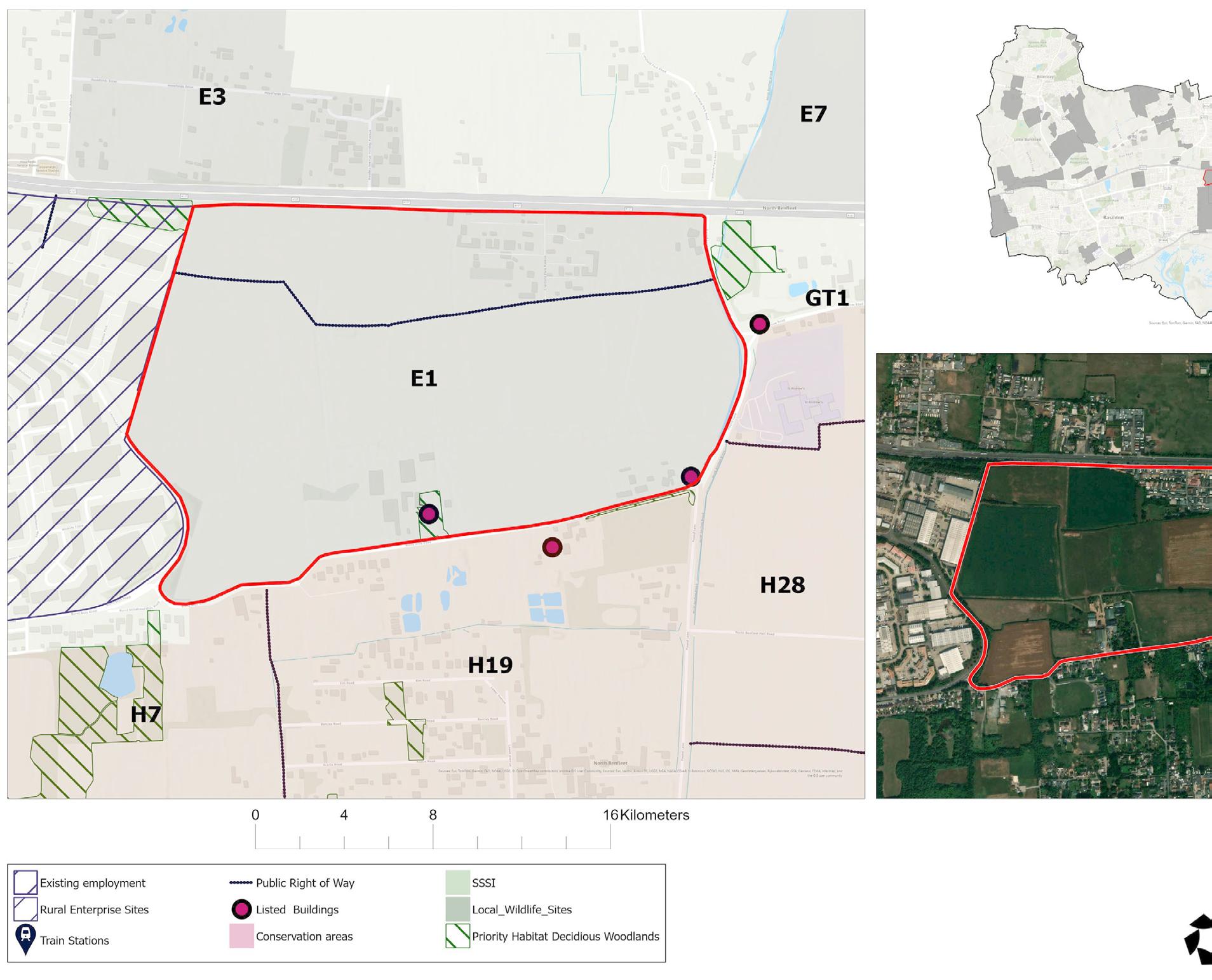
Figure 24: H23A-J Location Maps
POLICY GT1, Land South of Harrow Road
Allocation Information Details
Location Bowers Gifford and North Benfleet
Allocation area (ha) 3.11
Indicative capacity 25 Gypsy and Traveller Pitches
Phasing 2025-30
* For the purpose of calculating density, the net developable area includes residential plots, local streets, and small incidental open spaces. Larger areas of public open space, green infrastructure, sustainable drainage areas, and primary road corridors are excluded.
VISION
Our vision for Land South of Harrow Road (GT1) is to deliver a high-quality, councilled Gypsy and Traveller site that meets identified accommodation needs in a safe, inclusive, and well-managed environment. The site will provide 25 permanent pitches with appropriate infrastructure, landscaping, and access arrangements, ensuring long-term sustainability and integration with the surrounding area.
CORE PRINCIPLES
Land South of Harrow Road, Bowers Gifford, is allocated for 25 permanent Gypsy and Traveller pitches. Development proposals will deliver the following:
1. Retain existing hedgerows and deliver a comprehensive landscaping scheme to provide appropriate boundary treatments and mitigate visual impact.
2. Provide for and maintain visibility splay and access arrangements from Harrow Road.
3. Use permeable materials as hardstanding and provide drainage strategy to prevent surface run-off from the site.
4. Deliver high-quality amenity facilities for each pitch along with shared amenity space and provide access to high-quality open space.
5. Respond sensitively to the allocation’s heritage context and have regard to the Council’s High-Level Heritage Impact Assessment. A further detailed Heritage Impact Assessment must demonstrate how the proposal avoids or minimises conflict with the setting and significance of relevant heritage assets.
CHAPTER 15: Site Allocations – Gypsy and
Reasoned Justification
Land South of Harrow Road (GT1) allocates council-owned land south of Harrow Road for the delivery of 25 permanent Gypsy and Traveller pitches. The site will be delivered directly by Basildon Borough Council to meet the borough’s identified accommodation needs.
Green Belt
GT1 performs strongly against purposes (a) and (b) of the Green Belt with a moderate contribution to purpose (c). The site is part of the larger Green Belt parcel OA9 and is bound by site allocation H28 on its southern, eastern, and western sides and poorly performing Green Belt on the northern side. The site allocation is well-contained and benefits from existing hedgerows and landscape features that support visual integration and provide a defensible boundary. Development must retain and enhance these features, with a comprehensive landscaping scheme that supports biodiversity, climate resilience, and residential amenity.
Occupation
Occupation of the site will be restricted to persons meeting the planning definition of Gypsies and Travellers. The layout must provide adequate spacing between accommodation, internal roads, parking, and essential services, in accordance with national design principles and best practice. All infrastructure must be in place prior to first occupation.
Access
Vehicular access must be secured from Harrow Road, with appropriate visibility splays and drainage measures to prevent surface water runoff. The site’s delivery will contribute to a more balanced and
inclusive housing strategy, ensuring that the needs of all communities are met through high-quality, planned provision.
The proposed allocation has been informed by the Council’s assessment of reasonable alternatives and reflects a proactive approach to meeting identified needs. The site will be delivered as part of the Council’s strategic commitment to inclusive growth and sustainable development.
Heritage
A detailed Heritage Impact Assessment (HIA) has been undertaken for GT1 as part of the Regulation 18 consultation to consider the site’s suitability for allocation. To ensure the Allocation does not have the potential to result in the loss of the immediate rural setting, a detailed HIA must be undertaken at planning application stage.
E1, Burnt Mills
Site allocation context and description of existing
Burnt Mills (E1) is situated east of Basildon, encompassing 54.66 hectares of land currently occupied by a series of small industrial businesses, set within a context of former agricultural fields. It fronts the south side of the A127, bounded by Pound Lane to the east, as well as well-occupied industrial land to the west, and residential plotland sites to the south. Pitsea Station, located approximately three miles to the south, is accessible within a 15-minute cycle ride. In terms of environmental
constraints, a portion of the land, primarily in the north-east, is located within Flood Zone 3.
Figure 24: E1 Location Maps
POLICY E1, Burnt Mills
Allocation Information Details
Location Basildon / Bowers Gifford and North Benfleet
Total area (ha) 54.66
VISION
Our vision for Burnt Mills (E1) is the delivery of a strategic employment hub within the A127 corridor, focused on research and development and industrial processes. It will provide approximately 122,200 sqm of employment floorspace, creating high-quality, climate-resilient and sustainable locations with ancillary visually attractive amenity uses to support both new and existing businesses and their employees. With improved safe walking, cycling, and public transport links from Pitsea to ensure E1 provides accessible employment opportunities for local people.
CORE PRINCIPLES
Development proposals will deliver on the following:
1. Provide a coordinated mix of employment uses that support innovation, industrial activity, and job creation, with the phased and coordinated delivery of infrastructure and employment floorspace.
2. Where employment units are adjacent to residential dwellings, uses will be limited to Use Classes B2, B8, E(g) (ii), E(g)(iii), or work-live units (Sui Generis). Proposals should incorporate
green buffers to mitigate impacts.
Sustainability
3. Sustainability is to be at the heart of the proposal, including:
3.1 The design, operation, and adaptability of new buildings, reducing both operational and embodied carbon through a whole-life carbon approach, and integrating sustainable drainage measures such as blue-green roofing and vertical planting, ensuring no direct or cumulative increase in flood risk locally or within the wider catchment.
3.2 A well-integrated movement network that prioritises sustainable modes of transport, including walking, cycling, and public transport. Safe and inclusive access must be provided in accordance with Local Transport Authority policies.
3.3 A holistic approach to green infrastructure that delivers an ecologically-rich planting strategy across the whole allocation and provides multiple benefits, including climate resilience, support for active travel and wayfinding, improved
air quality, attractive and safe outdoor spaces for leisure, rest and employee wellbeing, and enhancements to local biodiversity and Green Belt boundaries.
3.4 Ensuring development is adaptable to changing business needs.
Infrastructure & connectivity
4. Provide a minimum of three Travelling Showpeople plots, integrated into the masterplan with associated infrastructure, to be secured by legal agreement.
5. Connect into and contribute towards the improvement of LCWIP Cycling Routes 1 and 13 to strengthen active travel links across the Borough. Development must provide secure and sheltered cycle parking and changing facilities to support active travel and reduce reliance on private vehicles.
6. Development proposals must be supported by a Traffic Impact Assessment (TIA) that identifies proportionate mitigation measures for both the local and strategic highway networks. The layout should allow flexibility for use by larger vehicles, including heavy goods vehicles (HGVs), where necessary. The TIA must also identify and contribute to opportunities to improve pedestrian and cycle infrastructure in line with the Basildon LCWIP, including enhancements to crossings and links that support the active-travel aspirations of Active Travel England (ATE).
7. Developer contributions must be secured for the delivery of highquality, frequent, and accessible public transport services to help reduce air
pollution.
8. Development must have essential services (water, electricity, and foul drainage) available on-site or able to be made available on-site. Foul drainage to a public sewer should be provided where possible. Where it is not, evidence will need to be provided showing that suitable alternative facilities can be provided.
Landscape & visual integration
9. Protect and enhance existing landscape features including field patterns, mature hedgerows, trees, and watercourses, ensuring minimal impact on the character and rural setting of the locality. Where loss is unavoidable, proposals must deliver suitable landscape mitigation.
10. Ensure the siting, form, materials and colour of buildings achieve an appropriately sensitive visual relationship with the surrounding buildings and landscape.
Heritage
11. Development is required to respond sensitively to the allocation’s heritage context and have regard to the Council’s High-Level Heritage Impact Assessment. A further detailed Heritage Impact Assessment must demonstrate how the proposal avoids or minimises conflict with the setting and significance of relevant heritage assets.
Flood risk & utility services
12. Development should accord with any flood mitigation and adaptation measures stated within the borough’s most recent Strategic Flood Risk Assessments.
CHAPTER 15: Site Allocations – Employment
Reasoned Justification
Burnt Mills is located within the strategic industrial and logistics corridor along the A127, making it well-placed to support employment growth and investment in Basildon Borough. The site allocation forms a contained extension to the existing employment area, supporting the delivery of identified employment land needs in a highly accessible location.
Visual integration and neighbouring amenity
The allocation is located on the eastern edge of the Burnt Mills Industrial Estate and marks the eastern extent of the Basildon Enterprise Corridor. As such, the northern and western parts of the allocation are less sensitive to employment development. Higher-sensitivity areas are located around existing residential dwellings, including the Grade II listed Bradfields Farmhouse and Cottage at the junction with Burnt Mills Road, where development should be designed to avoid adverse effects and incorporate appropriate mitigation.
The proximity of residential areas to the south necessitates the inclusion of a landscape buffer to protect amenity and ensure a sensitive transition between uses.
Bradfields Farm, a listed building within the allocation, requires a conservation-led approach to ensure its setting is preserved and, where possible, enhanced.
Green Belt
The allocation performs strongly against purposes (a) and (b) of the Green Belt and moderately against purpose (c). The proposed release of Green Belt
land has been informed by Basildon Borough Council’s assessment of all reasonable alternatives for meeting identified development needs, in line with the NPPF. The spatial strategy has considered brownfield opportunities, existing urban sites, density optimisation, and engagement with neighbouring authorities. Where Green Belt boundaries are amended, they will be defined through the master-planning process to ensure they are robust, defensible, and capable of enduring beyond the plan period.
Heritage
A high-level proforma Heritage Impact Assessment (HIA) has been undertaken for E1 as part of the Regulation 18 consultation to consider the site’s suitability for allocation. To ensure the allocation does not affect or cause unacceptable harm to the setting and significance of identified heritage assets including the Grade II listed Bradfield’s Farmhouse (within allocation), Horseshoe Cottage, Tiffayne’s Farmhouse and the Cottage at Junction with Burnt Mills Road and Tiffayne’s Farmhouse by virtue of building on historically undeveloped land and compromising the openness of the surrounding landscape, a detailed HIA must be undertaken at planning application stage. Mitigation and enhancement measures should explore how this harm can be minimised through the creation of green space to provide setbacks between development and the assets.
Flood Risk
Part of E1, along the eastern boundary, lies within Flood Zone 3b, while the remainder of the allocation falls within Flood Zone 1. The allocation is directly adjacent to North
Benfleet Brook.
A significant area across the southern part of E1 is located within NBAS_019 – Critical Drainage Area (CDA). Development sites located within a Critical Drainage Area should be designed to deliver additional benefits to the wider community through measures that contribute to flood risk reduction and improved surface water management, as per para 178 of the NPPF.
Site-specific flood risk assessments should take account of the borough’s most recent Strategic Flood Risk Assessments, including any recommended mitigation and adaptation measures.
Infrastructure
To ensure E1 can accommodate a flexible range of employment uses, including those requiring HGV access, proposals will need to demonstrate transport impacts through a Traffic and Highways Impact Assessment. This should identify proportionate mitigation measures to support improvements to the local and strategic highway networks.
For employment uses, early engagement with Anglian Water and Essex & Suffolk Water is particularly important, as neither water company has a statutory duty to supply non-domestic water. Applicants should therefore demonstrate that discussions with the relevant water provider have taken place at an early stage to confirm whether a suitable water supply can be secured and to identify any capacity or infrastructure constraints before the planning application is submitted.
E2, Dunton Boot Sale
Site allocation context and description of existing
Dunton Boot Sale (E2) is located to the northwest of Basildon and covers approximately 60 hectares. It includes the area currently used for the Dunton car boot sale, alongside a series of agricultural fields that contribute to the site’s predominantly rural character.
The southern boundary of E2 is defined by Dunton Road, which provides direct access and connectivity to the surrounding area. Beyond
the northern edge lie further agricultural fields, reinforcing the open landscape setting. To the southeast, the site allocation is in close proximity to allocation H9 and H10, highlighting its potential strategic relevance within the wider development framework.
Figure 24: H23A-J Location Maps
POLICY E2, Dunton Boot Sale
Allocation Information Details
Location Basildon
Total area (ha) 59.83
VISION
Our vision for Dunton Boot Sale (E2) is the creation of a rural enterprise site that accommodates small-scale, low-impact employment uses within a countryside setting. The allocation will provide flexible and adaptable workspaces for rural enterprises, start-ups, green industries, and other employment uses that respond sensitively to the landscape and reinforce a strong rural character. Development should integrate generous soft landscaping, outdoor amenity spaces for workers, and opportunities to frame views to the surrounding countryside.
Its proximity to strategic growth areas, including H9, H10 and Dunton Hills Garden Village, and the existing Dunton Ford Campus, creates opportunities for future operational linkages with nearby communities and employers, where appropriate. In addition to smaller units, the allocation may also support a limited number of moderately larger premises, provided they are designed to respect the rural setting through appropriate massing, form and landscape integration. This enables a broad range of employment formats and supports business growth on the site over time.
CORE PRINCIPLES
Development proposals will deliver on the following:
1. Provide low-impact, cohesive and complementary employment uses that support rural enterprise and job creation. The allocation should provide a mix of unit sizes to accommodate both small and moderately larger businesses, where these can be sensitively integrated into the countryside setting. Acceptable uses include those within Use Classes E(g) (i–iii), B2, B8, and Sui Generis where compatible with the rural character of the allocation.
Green Belt, landscape & visual integration
2. Protect designated ecological assets, including Lady Spring Wood, Gravel Pit Wood LoWS, and the River Crouch, with any public access designed in consultation with a certified ecologist to ensure biodiversity is safeguarded.
3. Development must demonstrate a landscape-led approach, incorporating high-quality structural planting and soft landscape buffers to create visual containment, a strong green setting, and, where appropriate, framed views towards the surrounding countryside.
CHAPTER 15: Site Allocations – Employment
4. Avoid adverse impacts on nearby residential areas and sensitive receptors, with appropriate mitigation and green buffers where necessary.
5. Protect and, where appropriate, strengthen existing boundary features that are recognisable and likely to remain permanent. Where the site’s boundary is not defined by recognisable or permanent features it should be addressed through the masterplan and design process in order to create secure, strong and defensible Green Belt boundaries.
6. Ensure the siting, form, materials and colour of buildings achieve an appropriately sensitive visual relationship with the surrounding rural landscape.
Sustainability
7. Sustainability is to be at the heart of the proposal and should include:
7.1 The design, operation, and adaptability of new buildings, reducing both operational and embodied carbon through a whole-life carbon approach, and integrating sustainable drainage measures such as blue-green roofing and vertical planting where appropriate, and ensuring no direct or cumulative increase in flood risk locally or within the wider catchment.
7.2 A well-integrated movement network that prioritises sustainable modes of transport, including walking, cycling, and public transport. Safe and inclusive access must be provided in accordance with Local Transport Authority policies.
7.3 A holistic approach to green infrastructure that delivers an ecologically rich planting strategy across the whole allocation and provides multiple benefits, including climate resilience, support for active travel and wayfinding, improved air quality, attractive and safe outdoor spaces for leisure, rest and employee wellbeing, and enhancements to local biodiversity and Green Belt boundaries.
7.4 Ensuring development is adaptable to changing business needs.
Connectivity & infrastructure
8. Development proposals must be supported by a Traffic Impact Assessment (TIA) that identifies proportionate mitigation measures for both the local and strategic highway networks. The layout should allow flexibility for use by larger vehicles, including heavy goods vehicles (HGVs), where necessary. The TIA must also identify and contribute to opportunities to improve pedestrian and cycle infrastructure in line with the Basildon LCWIP, including enhancements to crossings and links that support the active-travel aspirations of Active Travel England (ATE).
9. Development must provide secure and sheltered cycle parking and changing facilities to support active travel and reduce reliance on private vehicles.
10. Development must have essential services (water, electricity, and foul
drainage) available on-site or able to be made available on-site. Foul drainage to a public sewer should be provided where possible. Where it is not, evidence will need to be provided showing that suitable alternative facilities can be provided.
Heritage
11. Development is required to respond sensitively to the allocation’s heritage context and have regard to the Council’s High-Level Heritage Impact Assessment. A further detailed Heritage Impact Assessment must demonstrate how the proposal avoids or minimises conflict with the setting and significance of relevant heritage assets.
Reasoned Justification
Economy
The allocation of E2 supports the Council’s objective to diversify the local economy and provide opportunities for rural enterprise, particularly in green industries and small-scale manufacturing. Its proximity to the Dunton Ford Campus presents potential for small-scale innovation, green industries, training, and co-working spaces, helping to broaden the local employment offer.
E2 also sits within the strategic industrial and logistics corridor along the A127, making it well-placed to support employment growth and investment in Basildon Borough. Its location enables
Flood risk
12. Development should accord with any flood mitigation and adaptation measures stated within the borough’s most recent Strategic Flood Risk Assessments.
the allocation to contribute to the wider economic role of the A127 corridor while delivering development that is sensitive to its rural setting.
Landscape-led
The areas to the south, where existing employment buildings are located, and to the west and centre of the site, where land is influenced by boot-sale use, are of lower landscape sensitivity.
The eastern edge of the allocation is more sensitive due to the presence of Priority Habitat Woodland at Lady Spring Wood and the River Crouch with its associated
CHAPTER 15: Site Allocations – Employment
vegetated buffer to the south-east. Development near these features should be carefully managed to avoid adverse effects on landscape and ecological value. The northern part of the allocation is also more sensitive, being more open to the wider countryside with limited built influence.
Development must be carefully designed to respond to the site’s landscape setting, with strong emphasis on visual containment, structural planting and integration with green infrastructure. A landscape-led approach should create a rural business environment that retains countryside character, provides outdoor amenity for workers, and maintains framed views towards the wider landscape.
Green Belt
Allocation E2 lies to the north of the A127 on land that performs strongly against Green Belt purposes (a), (b), and (c). While it lacks strong boundary features, necessitating the creation of new defensible boundaries, it sits in close proximity to emerging development areas including H9, H10, and Dunton Hills Garden Village, offering opportunities for rural employment to complement planned housing growth.
The proposed release of Green Belt land has been informed by Basildon Borough Council’s assessment of all reasonable alternatives for meeting identified development needs, in line with the NPPF. The spatial strategy has considered brownfield opportunities, existing urban sites, density optimisation, and engagement with neighbouring authorities. Where Green Belt boundaries are amended, they will be defined through the master-planning process to ensure
they are robust, defensible, and capable of enduring beyond the plan period.
Heritage
A high-level proforma Heritage Impact Assessment (HIA) has been undertaken for E2 as part of the Regulation 18 consultation to consider the site’s suitability for allocation. To ensure the allocation does not affect or cause unacceptable harm to the setting and significance of the heritage asset the Grade II listed Rose Cottage and Ivy Cottage, by virtue of building on historically undeveloped land and compromising the openness of the surrounding landscape, a detailed HIA must be undertaken at planning application stage. Mitigation and enhancement measures should explore how this harm can be minimised through the creation of green space to provide setbacks between development and the assets.
Flood Risk
A small proportion of E2 is located within Flood Zone 3b in the southeast of the allocation, while the majority lies within Flood Zone 1. E2 is at risk from surface runoff originating from Botney Hill to the north, with the greatest impacts occurring in the southern part of the allocation.
Site-specific flood risk assessments should take account of the borough’s most recent Strategic Flood Risk Assessments, including any recommended mitigation and adaptation measures. Drainage strategies should evidence how the identified overland flow routes will be managed.
Infrastructure
For employment uses, early engagement with Anglian Water and Essex & Suffolk Water is particularly important, as neither water company has a statutory duty to supply non-domestic water. Applicants should therefore demonstrate that discussions with the relevant water provider have taken place at an early stage to confirm whether a suitable water supply can be secured and to identify any capacity or infrastructure constraints before the planning application is submitted.
Given the proximity of the proposed Norwich-Tilbury transmission route, applicants should have regard to emerging infrastructure proposals that
may inform the site’s masterplanning. Early engagement with National Grid is encouraged to identify any safeguarding requirements. Development near high-voltage transmission infrastructure must comply with the Electricity Safety, Quality and Continuity Regulations 2002 and National Grid’s Design Guidelines for Development Near Pylons and High Voltage Overhead Power Lines. These measures will help ensure that, should the Norwich–Tilbury Development Consent Order be granted, both new development and future transmission infrastructure can be safely accommodated without prejudice to either.
E3, Land Adjacent to Hovefields Avenue
Site allocation context and description of existing
Land Adjacent to Hovefields Avenue (E3) is located between Basildon and Wickford and covers approximately 17 hectares. It lies to the south of the Fairmead Plotlands and comprises a series of developed plots interspersed with areas of open scrub and grassland, creating an informal and semi-rural landscape. The allocation is accessed via several minor or unmade roads serving the existing plots, while the A127 forms a prominent southern boundary,
providing strong regional connectivity.
Adjacent land to the east and west consists of grassland and scrub with varying degrees of urban development. It is bounded by the remaining Fairmead Plotlands to the north, which will continue to be protected under Green Belt policy.
Figure 18: H17 Location Maps
POLICY E3, Land Adjacent to Hovefields Avenue
Allocation Information Details
Location Wickford
Total area (ha) 16.90
VISION
Our vision for Land Adjacent to Hovefields Avenue (E3) is the delivery of a carefully managed employment allocation that responds to the area’s semi-rural plotland character while supporting economic growth. Development will be low-impact, well-contained, and focused previously developed land. The allocation will contribute to Basildon’s employment strategy without undermining the openness of the remaining Green Belt. A strong landscape and design strategy will ensure that development is clearly contained and does not give rise to incremental expansion into the Plotlands to the north.
CORE PRINCIPLES
Development proposals will deliver on the following:
1. Provision of low-impact, cohesive and complementary employment uses that support local enterprise and job creation. Acceptable uses include those within Use Classes E(g) (i–iii), B2, B8, and Sui Generis.
2. Development should make efficient use of previously developed land while remaining compatible with the scale, form and character of the existing development.
Sustainability
3. Sustainability is to be at the heart of the proposal, including:
3.1 The design, operation, and adaptability of new buildings, reducing both operational and embodied carbon through a whole-life carbon approach, and integrating sustainable drainage measures such as blue-green roofing where appropriate, and ensuring no direct or cumulative increase in flood risk locally or within the wider catchment.
3.2 A well-integrated movement network that prioritises sustainable modes of transport, including walking, cycling, and public transport. Safe and inclusive access must be provided in accordance with Local Transport Authority policies.
3.3 A holistic approach to green infrastructure that delivers an ecologically rich planting strategy across the whole allocation and provides multiple benefits, including climate resilience, support for active travel and wayfinding, improved air quality, attractive and safe outdoor spaces for leisure, rest and employee wellbeing,
CHAPTER 15: Site Allocations – Employment
and enhancements to local biodiversity and Green Belt boundaries.
3.4 Ensuring development is adaptable to changing business needs.
Connectivity & infrastructure
4. Development proposals must be supported by a Traffic Impact Assessment (TIA) that identifies proportionate mitigation measures for both the local and strategic highway networks. The layout should allow flexibility for use by larger vehicles, including heavy goods vehicles (HGVs), where necessary. The TIA must also identify and contribute to opportunities to improve pedestrian and cycle infrastructure in line with the Basildon LCWIP, including enhancements to crossings and links that support the active-travel aspirations of Active Travel England (ATE).
5. Development must provide secure and sheltered cycle parking and changing facilities to support active travel and reduce reliance on private vehicles.
6. Development must have essential services (water, electricity, and foul drainage) available on-site or able to be made available on-site. Foul drainage to a public sewer should be provided where possible. Where it is not, evidence will need to be provided showing that suitable alternative facilities can be provided.
Green Belt & landscape sensitivity
7. Protect and, where appropriate, strengthen existing boundary features that are recognisable and
likely to remain permanent. Where the site’s boundary is not defined by recognisable or permanent features it should be addressed through the masterplan and design process in order for strong and defensible Green Belt boundaries to be created and secure.
8. Avoid adverse impacts on nearby residential areas and sensitive receptors, with appropriate mitigation and green buffers where necessary.
9. The existing planted boundary along the southern edge of the allocation, adjacent to the A127, must be retained and, where appropriate, strengthened to maintain visual containment.
Reasoned Justification
Land Adjacent to Hovefields Avenue (E3) lies within the southern portion of the Fairmead Plotlands, an area identified in the Basildon Plotlands Potential Growth Study (2024) as having limited development potential due to fragmented ownership, access constraints, and Green Belt sensitivity. However, the allocation consists largely of previously developed land that can be optimised to deliver employment uses, supporting the borough’s economic objectives without significantly increasing the perception of urban development from outside the allocation. The allocation contributes to the Council’s aim to diversify employment land supply and make use of underutilised land, while ensuring development is sustainable, well-integrated, and sensitive to its context.
Connectivity
The allocation’s proximity to the A127 employment corridor and the consented data centre to the west presents an opportunity to deliver employment uses that support the borough’s economic strategy. However, the A127 also creates a significant barrier to movement, limiting active travel connections to the south and requiring careful consideration of any new or improved access arrangements. Development must be supported by access testing and appropriate mitigation to ensure safe and inclusive movement for workers and vehicles.
Landscape
Much of the allocation is already developed in a plotlands pattern, with additional commercial and employment uses present. As a result, the allocation generally has a lower landscape sensitivity
to further employment development. Higher-sensitivity areas are limited, though existing mature vegetation should be retained where practicable, as it contributes to landscape structure and wider green infrastructure.
Green Belt
E3 lies within a Green Belt parcel that performs strongly against purposes (a), (b) and (c). Its release therefore requires careful justification and a landscape-led approach to ensure development remains contained and does not contribute to coalescence between Basildon and Wickford. While the parcel as a whole is sensitive, parts of the allocation comprise previously developed land, allowing development to be directed to areas where openness has already been eroded and can be optimised without materially increasing the perception of urban development. Strong landscape buffers and effective containment measures will be required to ensure that development remains well-defined and does not encourage incremental expansion into the Plotlands to the north.
The proposed release of Green Belt land has been informed by Basildon Borough Council’s assessment of all reasonable alternatives for meeting identified development needs, in line with the NPPF. The spatial strategy has considered brownfield opportunities, existing urban sites, density optimisation and engagement with neighbouring authorities. Any amended Green Belt boundaries will be defined through the masterplanning process to ensure they are robust, defensible and capable of enduring beyond the plan period.
CHAPTER 15: Site Allocations – Employment
Heritage
The proposed allocation is unlikely to impact the setting and significance of the designated heritage asset.
Flood Risk
E3 lies entirely within Flood Zone 1 and has been screened as low risk in the borough’s Strategic Flood Risk Assessment. Development should accord with Polices CC2 and CC3.
Infrastructure
For employment uses, early engagement with Anglian Water and Essex & Suffolk Water is particularly important, as neither water company has a statutory duty to supply non-domestic water. Applicants
should therefore demonstrate that discussions with the relevant water provider have taken place at an early stage to confirm whether a suitable water supply can be secured and to identify any capacity or infrastructure constraints before the planning application is submitted.
E4, Land West of Canvey Way
Site allocation context and description of existing
E4 is situated to the south of the Saddlers Farm roundabout and the A13 corridor, covering approximately 24 hectares. The allocation comprises a series of agricultural fields together with an area currently used for car boot sales. The landscape is predominantly rural in character, with open agricultural land to the west and the urban edge of South Benfleet to the east. Canvey Way (A130) forms the eastern boundary of the site, alongside a band of priority habitat deciduous woodland that
provides an important landscape and ecological feature.
Figure 24: H23A-J Location Maps
POLICY E4, Land West of Canvey Way
Allocation
Location Bowers Gifford and North Benfleet
Total area (ha) 23.66
VISION
Our vision for Land West of Canvey Way (E4) is to deliver a well-designed employment allocation that capitalises on the site’s strategic position along the A13 corridor while responding sensitively to its rural setting. Development will support logistics and industrial uses that benefit from excellent highway access, while being landscape-led, visually contained, and integrated with the surrounding countryside. High-quality planting and green infrastructure will soften built form and manage visual impact, ensuring that development enhances local character rather than eroding it. The allocation will also improve active travel connectivity to new housing areas to the north, supporting sustainable access to employment opportunities.
CORE PRINCIPLES
Development proposals will deliver on the following:
1. Support employment uses within Use Classes E(g) (i–iii), B2, and B8, including larger-format logistics and industrial units. Proposals must demonstrate how harm to the rural character will be minimised through careful siting, scale, and design.
Landscape sensitivity & visual integration
2. Development must demonstrate a landscape-led approach, incorporating high-quality structural planting and soft landscape buffers to create visual containment and a strong green setting.
3. Protect and enhance existing landscape features including field patterns, mature hedgerows, and trees, ensuring minimal impact on the character and rural setting of the locality. Where loss is unavoidable, proposals must deliver suitable landscape mitigation.
4. Ensure the siting, form, materials and colour of buildings achieve an appropriately sensitive visual relationship with the surrounding rural landscape.
5. Protect and, where appropriate, strengthen existing boundary features that are recognisable and likely to remain permanent. Where the site’s boundary is not defined by recognisable or permanent features it should be addressed through the masterplan and design process in order for strong and defensible Green Belt boundaries to be created and secured.
Sustainability
6. Sustainability is to be at the heart of the proposal, including:
6.1 The design, operation, and adaptability of new buildings, reducing both operational and embodied carbon through a whole-life carbon approach, and integrating sustainable drainage measures such as blue-green roofing where appropriate, and ensuring no direct or cumulative increase in flood risk locally or within the wider catchment.
6.2 A well-integrated movement network that prioritises sustainable modes of transport, including walking, cycling, and public transport. Safe and inclusive access must be provided in accordance with Local Transport Authority policies.
6.3 A holistic approach to green infrastructure that delivers an ecologically rich planting strategy across the whole allocation and provides multiple benefits, including climate resilience, support for active travel and wayfinding, improved air quality, attractive and safe outdoor spaces for leisure, rest and employee wellbeing, and enhancements to local biodiversity and Green Belt boundaries.
6.4 Ensuring development is adaptable to changing business needs.
Connectivity & infrastructure
7. Vehicular access to the allocation will
be provided from Canvey Way (A130) on the eastern boundary. Any future application must demonstrate how impacts on the existing deciduous woodland will be minimised and, where tree loss is unavoidable as a result of creating the access, set out appropriate on- or off-site mitigation measures.
8. Development proposals must be supported by a Traffic Impact Assessment (TIA) that identifies proportionate mitigation measures for both the local and strategic highway networks. The layout should allow flexibility for use by larger vehicles, including heavy goods vehicles (HGVs), where necessary. The TIA must also identify and contribute to opportunities to improve pedestrian and cycle infrastructure in line with the Basildon LCWIP, including enhancements to crossings and links that support the active-travel aspirations of Active Travel England (ATE).
9. Development must provide secure and sheltered cycle parking and changing facilities to support active travel and reduce reliance on private vehicles.
10. Development must have essential services (water, electricity, and foul drainage) available on-site or able to be made available on-site. Foul drainage to a public sewer should be provided where possible. Where it is not, evidence will need to be provided showing that suitable alternative facilities can be provided.
Heritage
11. Development is required to respond sensitively to the allocation’s heritage context and have regard to the
CHAPTER 15: Site Allocations – Employment
Council’s High-Level Heritage Impact Assessment. A further detailed Heritage Impact Assessment must demonstrate how the proposal avoids or minimises conflict with the setting and significance of relevant heritage assets.
Flood risk
12. Designs must be informed by a Flood Risk Assessment, demonstrating there is no direct or cumulative increase in flood risk locally or elsewhere in the catchment arising from the development.
Reasoned Justification
Land West of Canvey Way (E4) lies to the south of the A13 and Saddlers Farm roundabout, within a predominantly rural landscape. Its strategic location adjacent to the A13 makes it particularly well-suited to logistics, distribution and industrial uses that benefit from direct access to the strategic road network. By utilising the A13 corridor, E4 provides an alternative choice of employment land to sites located along the A127. The allocation supports the Council’s objective to diversify employment land supply and explore long-term opportunities for strategic employment growth.
Connectivity
While the allocation benefits from proximity to the strategic road network, surrounding infrastructure creates severance, limiting active travel options and requiring detailed testing and mitigation to ensure safe and efficient movement for workers and vehicles. Active travel improvements could include enhanced links and upgrades to the underpass route to London Road (including lighting and maintenance), which in turn provides access to the wider walking, cycling and bus network.
Landscape
The northern edge of the allocation is less sensitive to development owing to the influence of the adjacent major road network and the condition of the field used for the Saddlers Farm Boot Sale. Areas of vegetation along field boundaries and site edges, together with isolated mature trees within the site, should be protected where practicable, as they provide important links to the wider green infrastructure network. The southern part of the allocation is more sensitive due to its increased rural character and its relationship with the wider countryside setting.
Development must be carefully designed to respond to the site’s landscape setting, with strong emphasis on visual containment, structural planting and integration with green infrastructure. A landscape-led approach should create a well-designed employment environment that softens built form, provides outdoor amenity space for workers and maintains framed views towards the wider rural landscape.
Landscape buffers should create a gradual transition in vegetation structure. Their detailed design and composition will be determined through the planning application process, informed by relevant site-specific assessments.
Green Belt
The allocation lies on highly performing Green Belt land, contributing strongly to purposes (a), (b), and (c) of the Green Belt. The proposed release of Green Belt land has been informed by Basildon Borough Council’s assessment of all reasonable alternatives for meeting identified development needs, in line
with the NPPF. The spatial strategy has considered brownfield opportunities, existing urban sites, density optimisation, and engagement with neighbouring authorities. Where Green Belt boundaries are amended, they will be defined through the master-planning process to ensure they are robust, defensible, and capable of enduring beyond the plan period.
Heritage
A high-level proforma Heritage Impact Assessment (HIA) has been undertaken for E4 as part of the Regulation 18 consultation to consider the site’s suitability for allocation. To ensure the allocation does not affect or cause unacceptable harm to the setting and significance of the Grade II* listed Church of St Margaret, by virtue of building on agrarian fields and compromising the openness of the surrounding landscape, a detailed HIA must be undertaken at planning application stage. Mitigation and enhancement measures should include focussing built development on the northernmost half of the allocation and should explore how this harm can be minimised through the creation of green space to provide setbacks between development and the asset.
Flood Risk
E4 lies entirely within Flood Zone 1 and has been screened as low risk in the borough’s Strategic Flood Risk Assessment. Development should accord with Polices CC2 and CC3.
Infrastructure
To ensure E4 can accommodate a flexible range of employment uses, including those requiring HGV access, proposals will need to demonstrate transport impacts through a Traffic and Highways
CHAPTER 15: Site Allocations – Employment
Impact Assessment. This should identify proportionate mitigation measures to support improvements to the local and strategic highway networks.
For employment uses, early engagement with Anglian Water and Essex & Suffolk Water is particularly important, as neither water company has a statutory duty to supply non-domestic water. Applicants should therefore demonstrate that discussions with the relevant water provider have taken place at an early stage to confirm whether a suitable water supply can be secured and to identify any capacity or infrastructure constraints before the planning application is submitted.
E5, Friern Manor Farm
Site allocation context and description of existing
Friern Manor Farm (E5) is located to the northwest of Basildon, covering approximately 12 hectares. It comprises a sequence of agricultural fields defined by tree-lined field boundaries. An isolated employment site lies at the centre of the allocation. Priority habitat deciduous woodland lies directly to the west, forming an important landscape and ecological feature. To the southwest, the allocation currently adjoins open countryside, although this area is allocated as part of the future
Dunton Hills Garden Village. The A127 forms the northern boundary, with residential allocation H9 to the south and the built up area of Basildon to the east. A National Gas Transmission Pipeline intersects the allocation boundary.
Figure 24: H23A-J Location Maps
POLICY E5, Friern Manor Farm
VISION
Our vision for Friern Manor Farm (E5) is to deliver high-quality employment development within the A127 corridor, supporting industrial and researchbased uses that contribute to Basildon’s economic growth. Development will complement nearby strategic employment areas, sit comfortably within its rural edge setting, and integrate sensitively with the surrounding landscape and heritage assets.
CORE PRINCIPLES
Development proposals will deliver on the following:
1. Support employment uses within Use Classes B2, B8, E(g) (i–iii), and Sui Generis, including industrial, logistics, and research-based activities appropriate to the allocation’s strategic location.
Landscape sensitivity & visual integration
2. Respond sensitively to the rural character and field structure. Existing field boundaries, mature hedgerows and trees, particularly those around the site perimeter, should be retained
and enhanced wherever practicable to reinforce containment and visual integration. Where loss is unavoidable, proposals must deliver suitable landscape mitigation.
3. Ensure the siting, form, materials and colour of buildings achieve an appropriately sensitive visual relationship with the surrounding rural landscape.
Sustainability
4. Sustainability is to be at the heart of the proposal, including:
4.1 The design, operation, and adaptability of new buildings, reducing both operational and embodied carbon through a whole-life carbon approach, and integrating sustainable drainage measures such as blue-green roofing where appropriate, and ensuring no direct or cumulative increase in flood risk locally or within the wider catchment.
4.2 A well-integrated movement network that prioritises sustainable modes of transport, including walking, cycling, and public transport. Safe and inclusive access must be provided in accordance with Local Transport Authority
policies.
4.3 A holistic approach to green infrastructure that delivers an ecologically rich planting strategy across the whole allocation and provides multiple benefits, including climate resilience, support for active travel and wayfinding, improved air quality, attractive and safe outdoor spaces for leisure, rest and employee wellbeing, and enhancements to local biodiversity and Green Belt boundaries.
4.4 Ensuring development is adaptable to changing business needs.
Connectivity & infrastructure
5. Development proposals must be supported by a Traffic Impact Assessment (TIA) that identifies proportionate mitigation measures for both the local and strategic highway networks. The layout should allow flexibility for use by larger vehicles, including heavy goods vehicles (HGVs), where necessary. The TIA must also identify and contribute to opportunities to improve pedestrian and cycle infrastructure in line with the Basildon LCWIP, including enhancements to crossings and links that support the active-travel aspirations of Active Travel England (ATE).
6. Pedestrian and cycle links within the allocation should be available towards the H9 residential allocation to provide connectivity between the two allocations along direct desire lines.
7. Development must provide secure and
sheltered cycle parking and changing facilities to support active travel and reduce reliance on private vehicles.
8. Development must have essential services (water, electricity, and foul drainage) available on-site or able to be made available on-site. Foul drainage to a public sewer should be provided where possible. Where it is not, evidence will need to be provided showing that suitable alternative facilities can be provided.
Heritage
9. Development is required to respond sensitively to the allocation’s heritage context and have regard to the Council’s High-Level Heritage Impact Assessment. A further detailed Heritage Impact Assessment must demonstrate how the proposal avoids or minimises conflict with the setting and significance of relevant heritage assets.
Flood risk & water management
10. Development should accord with any flood mitigation and adaptation measures stated within the borough’s most recent Strategic Flood Risk Assessments.
CHAPTER 15: Site Allocations – Employment
Reasoned Justification
Friern Manor Farm (E5) is located within the A127 employment corridor, adjacent to the West Mayne roundabout and in close proximity to strategic growth areas including H9, H10, and Dunton Hills Garden Village. Its location offers excellent connectivity to the strategic road network, making it well-suited to accommodate industrial and logistics uses that benefit from direct access to the A127.
Uses
While E5 has attracted interest for specialist employment uses, its allocation is intended to support a broad range of industrial and research-based activities within Use Classes B2, B8, E(g)(i-iii), and Sui Generis. Development could complement nearby strategic employers, including Ford, and should contribute to the borough’s wider economic objectives.
The allocation is not considered suitable for residential development due to its location adjacent to the West Mayne roundabout and the A127, which presents challenges in terms of amenity and accessibility. Employment-led development offers a more appropriate and sustainable use of the land, supporting job creation and infrastructure delivery in a strategically important location.
Connectivity
Pedestrian and cycle connections to the H9 allocation should be provided to support sustainable access to employment.
Cross-boundary coordination with Brentwood will be essential, particularly in relation to highways, active travel and sustainable transport. This includes ensuring connectivity with Dunton Hills Garden Village and aligning movement
strategies to support sustainable transport across administrative boundaries.
Landscape
The northern edge of the allocation is less sensitive to development owing to the influence of the adjacent major road network, while existing development towards the centre further reduces sensitivity in this area.
PRoW West Horndon 69 runs along the western edge of the allocation and offers open views across the land. Although the character of the route will change as development comes forward, its alignment and amenity should be retained and enhanced through sensitive design and landscaping.
Vegetation on the site is limited, but notable mature trees along historic field boundaries contribute to landscape structure and provide links to the wider green infrastructure network. These trees should be retained where practicable. The woodland adjoining the western boundary is Priority Habitat Deciduous Woodland and should be protected, with development set back to avoid adverse effects on this feature. Where required, landscape buffers should create a gradual transition in vegetation structure.
Green Belt
The allocation contributes strongly to Green Belt purpose (a), weakly against purpose (b), and moderately against purpose (c). The proposed release of Green Belt land has been informed by Basildon Borough Council’s assessment of all reasonable alternatives for meeting identified development needs, in line with the NPPF. The spatial strategy has
considered brownfield opportunities, existing urban sites, density optimisation, and engagement with neighbouring authorities. Where Green Belt boundaries are amended, they will be defined through the master-planning process to ensure they are robust, defensible, and capable of enduring beyond the plan period.
Heritage
A high-level Heritage Impact Assessment (HIA) has been undertaken for E5 as part of the Regulation 18 consultation to consider the site’s suitability for allocation. To ensure the allocation does not have the potential to affect, and cause unacceptable harm to the setting and significance of the Grade II listed building to the north of the site, Wayletts, by virtue of building on arable land historically associated with it and compromising the openness of the surrounding landscape, a detailed HIA must be undertaken at planning application stage.
Flood risk
The entire E5 allocation lies within Flood Zone 1. The primary flood risk is pluvial, with surface water flooding identified in the northeast of the allocation. A tributary of the River Crouch runs adjacent to the northeastern boundary.
Site-specific flood risk assessments should take account of the borough’s most recent Strategic Flood Risk Assessments, including any recommended mitigation and adaptation measures. The drainage strategy should demonstrate how areas identified as being at risk of surface water flooding will be managed. Development should have safe access and egress, incorporate flood-resilient design, and should not increase flood risk elsewhere.
Infrastructure
A National Gas Transmission Pipeline runs along the western boundary of the allocation, and its operational requirements must be fully considered in the layout and design of the allocation. A supporting strategy is therefore required to show how the National Gas Design Guide Principles have informed the masterplanning process, ensuring appropriate stand-offs, access for maintenance, and safe co-existence between new development and the gas infrastructure.
Given the proximity of the proposed Norwich-Tilbury transmission route, applicants should have regard to emerging national infrastructure proposals that may inform the site’s masterplanning. Early engagement with National Grid is encouraged to identify any safeguarding requirements. Development near high-voltage transmission infrastructure must comply with the Electricity Safety, Quality and Continuity Regulations 2002 and National Grid’s Design Guidelines for Development Near Pylons and High Voltage Overhead Power Lines. These measures will help ensure that, should the Norwich–Tilbury Development Consent Order be granted, both new development and future transmission infrastructure can be safely accommodated without prejudice to either.
For employment uses, early engagement with Anglian Water and Essex & Suffolk Water is particularly important, as neither water company has a statutory duty to supply non-domestic water. Applicants should therefore demonstrate that discussions with the relevant water provider have taken place at an early stage to confirm whether a suitable water supply can be secured and to identify any capacity or infrastructure constraints before the planning application is submitted.
E6, South of Nevendon Road
Site allocation context and description of existing
South of Nevendon Road (E6) is to the north-east of Basildon, directly adjoining the Nevendon Roundabout, and covers approximately 7 hectares. The allocation comprises a single agricultural field enclosed by hedgerow-lined roads. To the south and northwest lie the A127 and A132, forming major road boundaries. To the east, Old Nevendon Road serves scattered residential properties and small industrial uses. Beyond the A132 to the west lies land occupied by an established
animal welfare use, with open countryside extending further north and west, all of which will remain within the Green Belt. Fairmead Plotlands lies to the east and will continue to be protected within the Green Belt. To the south, the land relates to Basildon’s A127 employment corridor, providing a strategic economic context for the allocation.
Figure 24: H23A-J Location Maps
POLICY E6, South of Nevendon Road
Allocation
Location Basildon
Total area (ha) 7.41
VISION
Our vision for South of Nevendon Road (E6) is to deliver a strategic employment allocation that supports technical and innovation-based industries along the A127 corridor. Development will be landscape-led, well-contained and sensitively integrated with surrounding Green Belt land, maintaining a clear separation between Basildon and Wickford. High-quality public realm and planting will create attractive, healthy spaces for workers while supporting biodiversity and climate resilience.
CORE PRINCIPLES
Development proposals will deliver on the following:
1. Support employment uses within Use Classes B8, E(g)(i–iii), and appropriate Sui Generis uses, particularly those that support technical innovation and job creation.
Landscape sensitivity & visual integration
2. Ensure the siting, form, materials and colour of buildings achieve an appropriately sensitive visual relationship with the surrounding rural
landscape. Development must avoid eroding the perceived separation between Basildon and Wickford. Landscape design should incorporate structural planting to soften built form, reinforce site boundaries, and ensure the development integrates sensitively with the surrounding countryside.
3. Respond sensitively to the rural character and field structure. Existing field boundaries, mature hedgerows and trees, particularly those around the site perimeter, should be retained and enhanced wherever practicable to reinforce containment and visual integration. Where loss is unavoidable, proposals must deliver suitable landscape mitigation.
4. Provide a landscape buffer along the eastern boundary to protect the amenity of nearby homes and ensure sensitive visual integration.
Sustainability
5. Sustainability is to be at the heart of the proposal, including:
5.1 The design, operation, and adaptability of new buildings, reducing both operational and embodied carbon through a whole-life carbon approach, and integrating sustainable drainage measures such as blue-green
CHAPTER 15: Site Allocations – Employment
roofs where appropriate, ensuring no direct or cumulative increase in flood risk locally or within the wider catchment.
5.2 A well-integrated movement network that prioritises sustainable modes of transport, including walking, cycling, and public transport. Safe and inclusive access must be provided in accordance with Local Transport Authority policies.
5.3 A holistic approach to green infrastructure that delivers an ecologically rich planting strategy across the whole allocation and provides multiple benefits, including climate resilience, support for active travel and wayfinding, improved air quality, attractive and safe outdoor spaces for leisure, rest and employee wellbeing, and enhancements to local biodiversity and Green Belt boundaries.
5.4 Ensuring development is adaptable to changing business needs.
Connectivity & infrastructure
6. Development proposals must be supported by a Traffic Impact Assessment (TIA) that identifies proportionate mitigation measures for both the local and strategic highway networks. The layout should allow flexibility for use by larger vehicles, including heavy goods vehicles (HGVs), where necessary. The TIA must also identify and contribute to opportunities to improve pedestrian and cycle infrastructure in line
with the Basildon LCWIP, including enhancements to crossings and links that support the active-travel aspirations of Active Travel England (ATE).
7. Development must provide secure and sheltered cycle parking and changing facilities to support active travel and reduce reliance on private vehicles.
8. Development must have essential services (water, electricity, and foul drainage) available on-site or able to be made available on-site. Foul drainage to a public sewer should be provided where possible. Where it is not, evidence will need to be provided showing that suitable alternative facilities can be provided.
Heritage
9. Development is required to respond sensitively to the allocation’s heritage context and have regard to the Council’s High-Level Heritage Impact Assessment. A further detailed Heritage Impact Assessment must demonstrate how the proposal avoids or minimises conflict with the setting and significance of relevant heritage assets.
Flood risk
10. Development should accord with any flood mitigation and adaptation measures stated within the borough’s most recent Strategic Flood Risk Assessments.
Reasoned Justification
South of Nevendon Road (E6) occupies a strategically important location adjacent to the A127 employment corridor and offers an opportunity to deliver new employment floorspace that supports technical and innovation-based industries. Its position to the north-east of Basildon, proximity to Wickford, and relationship with the Green Belt between them mean that development must be landscape-led and carefully integrated to respect the separation of the two settlements.
Employment Uses
The allocation is not considered appropriate for any residential development including work-live units. Its proximity to the A127 and Nevendon Junction results in elevated levels of noise and air pollution, and the configuration of nearby road infrastructure constrains safe and convenient residential access, including for active travel. Collectively, these factors would limit the ability to achieve an acceptable residential environment and effective connectivity to local facilities. Furthermore, the more dispersed pattern of built form typically associated with residential urban extensions would be difficult to accommodate without materially altering the character of the settlement edge.
The site’s environmental conditions and physical characteristics lend themselves to employment uses. Consolidated employment parcels can be arranged with appropriate set-backs, landscape buffers and structural planting, allowing building massing and associated activity to be contained within a coherent landscape framework and helping maintain the distinction between surrounding settlements.
The allocation benefits from direct access to the strategic road network, making it well-suited to accommodate industrial and innovation-led employment uses. Recent planning consents for a data centre and a battery charging facility reflect the allocation’s emerging role in supporting technical infrastructure, including Sui Generis uses.
Connectivity
While the allocation benefits from proximity to the strategic road network, surrounding infrastructure creates severance, limiting active travel options and requiring detailed testing and mitigation to ensure safe and efficient movement for workers and vehicles. Development must therefore prioritise active travel improvements, including enhancements to signalised crossings and underpasses, to ensure safe and inclusive access for workers. Proposals must be supported by a Traffic Impact Assessment to identify proportionate mitigation measures and ensure the allocation can accommodate a range of vehicle types, including HGVs.
Landscape sensitivity
There are areas of mature vegetation to the field boundaries and around the more developed area to the east. These should be protected as they form important links to the wider green infrastructure. Landscape buffers should create a gradual transition in vegetation structure. Their detailed design and composition will be determined through the planning application process, informed by relevant site-specific assessments.
CHAPTER 15: Site Allocations – Employment
Green Belt
Allocation E6 lies to the south of the wider Green Belt parcel BA15, which contributes strongly to Green Belt purposes (a), (b) and (c). Amendment to the Green Belt in this location requires robust, defensible and enduring boundaries to protect the remainder of the parcel.
The proposed release of Green Belt land has been informed by Basildon Borough Council’s assessment of all reasonable alternatives for meeting identified development needs, in line with the NPPF. The spatial strategy has considered brownfield opportunities, existing urban sites, density optimisation, and engagement with neighbouring authorities. Where Green Belt boundaries are amended, they will be defined through the master-planning process to ensure they are capable of enduring beyond the plan period.
Heritage
A high-level proforma Heritage Impact Assessment (HIA) has been undertaken for E6 as part of the Regulation 18 consultation to consider the site’s suitability for allocation. To ensure the allocation does not affect or cause unacceptable harm to the setting and significance of heritage assets, Grade II listed Nevendon Manor and Fore Riders, by virtue of building on land historically associated with them, compromising the openness of the surrounding landscape, and obscuring important views to and from the assets, a detailed HIA must be undertaken at planning application stage. Mitigation and enhancement measures should consider how any harm can be minimised, including through the use of green space and appropriate setbacks to help the development respond sensitively to the assets’ rural setting.
Flood risk and water management
The allocation is located in Flood Zone 1. The allocation is at risk from surface water flooding. There are several small watercourses located in and along the allocation. The risk for surface water flooding is distributed across the allocation.
The majority of the allocation is located within the NBAS_012 – Bromfords critical drainage area (CDA). Development sites located within a Critical Drainage Area should be designed to deliver additional benefits to the wider community through measures that contribute to flood risk reduction and improved surface water management, as per para 178 of the NPPF(2024).
Site-specific flood risk assessments should take account of the borough’s most recent Strategic Flood Risk Assessments, including any recommended mitigation and adaptation measures. The drainage strategy should demonstrate how areas identified as being at risk of surface water flooding will be managed.
Infrastructure
For employment uses, early engagement with Anglian Water and Essex & Suffolk Water is particularly important, as neither water company has a statutory duty to supply non-domestic water. Applicants should therefore demonstrate that discussions with the relevant water provider have taken place at an early stage to confirm whether a suitable water supply can be secured and to identify any capacity or infrastructure constraints before the planning application is submitted.
E7, South of Fanton Hall Farm
24: H23A-J Location Maps
Site allocation context and description of existing
South of Fanton Hall Farm (E7) is located to the southeast of Wickford and north of North Benfleet, covering approximately 85 hectares. It comprises a series of agricultural fields defined by mature hedgerows, contributing to the area’s rural character. A number of minor roads cross the allocation, providing access to scattered farms and small clusters of industrial and residential uses. A concentration of commercial activity lies to the southeast of the allocation.
The A127 forms the southern boundary, while the A130 lies to the east, and the railway line runs along the northeastern edge of the allocation. To the northwest, E7 is adjacent to The Wick Country Park and to the south lies allocation H28, highlighting the site allocation’s proximity to planned development areas and its potential role in supporting future growth.
Figure
POLICY E7, South of Fanton Hall Farm
Allocation
Location Wickford
Total area (ha) 84.81
VISION
Our vision for land south of Fanton Hall Farm (E7), is for delivery of a cohesive and complementary mix of employment uses. This will optimise the site allocation’s full potential to create a strategic employment hub. The development will support job creation, infrastructure improvements and the delivery of high-quality sustainable growth. It will also include ancillary amenity uses for new and surrounding companies; with cycle, walking and new public transport links.
CORE PRINCIPLES
Development proposals will deliver on the following:
1. Provide a coordinated mix of employment uses that would support innovation, industrial activities and job creation with phased and complementary delivery of infrastructure and employment floorspace. Employment uses will relate effectively to existing employment provision within the A127 and Cranfield Park Road.
2. Placement of sensitively designed employment uses adjacent to residential buildings shall be limited to Use Classes E(g(ii), E(g)(iii) or
work-live units (Sui Generis) with a landscape buffer provided.
Landscape sensitivity & visual integration
3. A permanent semi-natural buffer must be provided to prevent coalescence between Basildon, Wickford, and neighbouring authorities. Its location must be agreed and coordinated with adjoining employment allocation E7 to ensure a continuous and effective separation.
4. Protect and enhance existing landscape features including field pattern, mature hedgerows, trees, and watercourses, ensuring minimal impact on the character and rural setting of the locality. Where loss is unavoidable, proposals shall deliver suitable landscape mitigation.
5. Ensure the siting, form, materials and colour of buildings achieve an appropriately sensitive visual relationship with the surrounding rural landscape.
6. Protect and, where appropriate, strengthen existing boundary features that are recognisable and likely to remain permanent. Where the site’s boundary is not defined by recognisable or permanent features it should be addressed through the masterplan and design process in
order to create secure, strong and defensible Green Belt boundaries.
Sustainability
7. Sustainability is to be at the heart of the proposal, including:
7.1 The design, operation, and adaptability of new buildings, reducing both operational and embodied carbon through a whole-life carbon approach, and integrating sustainable drainage measures such as blue-green roofing where appropriate, ensuring no direct or cumulative increase in flood risk locally or to the wider catchment.
7.2 A well-integrated movement network that prioritises sustainable modes of transport, including walking, cycling, and public transport. Safe and inclusive access must be provided in accordance with Local Transport Authority policies.
7.3 A holistic approach to green infrastructure that delivers an ecologically rich planting strategy across the whole allocation and provides multiple benefits, including climate resilience, support for active travel and wayfinding, improved air quality, attractive and safe outdoor spaces for leisure, rest and employee wellbeing, and enhancements to local biodiversity and Green Belt boundaries.
7.4 Ensuring development is adaptable to changing business needs.
Connectivity & infrastructure
8. Development proposals must be supported by a Traffic Impact Assessment (TIA) that identifies proportionate mitigation measures for both the local and strategic highway networks. The layout should allow flexibility for use by larger vehicles, including heavy goods vehicles (HGVs), where necessary. The TIA must also identify and contribute to opportunities to improve pedestrian and cycle infrastructure in line with the Basildon LCWIP, including enhancements to crossings and links that support the active-travel aspirations of Active Travel England (ATE).
9. Development must provide secure and sheltered cycle parking and changing facilities to support active travel and reduce reliance on private vehicles.
10. Development must have essential services (water, electricity, and foul drainage) available on-site or able to be made available on-site. Foul drainage to a public sewer should be provided where possible. Where it is not, evidence will need to be provided showing that suitable alternative facilities can be provided.
Heritage
11. Development is required to respond sensitively to the allocation’s heritage context, including the World War II GHQ line and pillboxes and have regard to the Council’s High-Level Heritage Impact Assessment.
Flood risk
12. Development shall accord with any flood mitigation and adaptation
CHAPTER 15: Site Allocations – Employment
measures stated within the borough’s most recent Strategic Flood Risk Assessments.
Reasoned Justification
Allocation E7 lies between Wickford and North Benfleet, adjacent to the A127 and A130, and forms part of the borough’s strategic employment corridor. The site’s scale and accessible location make it appropriate for industrial and logistics uses that contribute to long-term economic growth, provided the masterplan maintains clear settlement separation between Basildon, North Benfleet and Wickford.
Connectivity
Given the site’s position between the A127, A130 and the railway line, the surrounding infrastructure creates severance that
limits active travel opportunities. Access arrangements will therefore need to be informed by robust transport assessment and appropriate mitigation to ensure safe and efficient movement for both workers and vehicles. Development should prioritise improvements to walking and cycling routes, including enhancements to signalised crossings and underpasses, to provide safe and inclusive access. Consideration will also need to be given to the relationship with allocation H13 to ensure a comprehensive and coordinated approach to movement that does not adversely affect residential development within that allocation.
Proposals must be supported by a Traffic Impact Assessment that identifies proportionate mitigation measures and demonstrates that the allocation can accommodate a range of vehicle types, including HGVs. Basildon Borough Council acknowledges that access solutions may also require coordination with neighbouring authorities. The use of the existing railway crossing to Rochford could be explored an active travel route, subject to viability and meaningful cross-boundary collaboration.
Landscape
The allocation’s rural character, defined by agricultural fields and mature hedgerows, requires a landscape-led approach to ensure visual containment and integration with the surrounding countryside.
A permanent semi-natural buffer must be provided to prevent coalescence between Basildon and Wickford. The precise location of this buffer will need to be agreed and coordinated with the adjoining housing allocation H13 to ensure an effective separation between settlements.
Areas to the north of the allocation are influenced by the industrial development at Fanton Hall, creating lower landscape sensitivity in this part of the allocation. Other parts of the allocation are affected by the adjacent road and rail network and by overhead power lines, which further reduce sensitivity in these locations.
Wick Country Park LoWS and an area of Priority Habitat Deciduous Woodland lie to the north-west of the site. Mature vegetated field boundaries across the allocation also contribute to green infrastructure connectivity. These features should be protected where practicable and
integrated into the landscape framework. Several waterbodies, including a reservoir, Chichester Hall Brook and Benfleet Brook, are located on or adjacent to the site; development should be set back from these riparian features to safeguard their ecological and landscape value.
The proximity to Wick Country Park and the North Benfleet Brook presents opportunities to enhance green infrastructure with layered planting to support biodiversity, while ensuring development complements the seminatural character of the park.
PRoW Bridleway Basildon 192 runs along Doublegate Lane on the northern edge before crossing the eastern part of the allocation. Its route and amenity should be retained and enhanced through sensitive design.
Green Belt
The site allocation performs strongly against purposes (a), (b), and (c) of the Green Belt. The proposed release of Green Belt land has been informed by Basildon Borough Council’s assessment of all reasonable alternatives for meeting identified development needs, in line with the NPPF. The spatial strategy has considered brownfield opportunities, existing urban sites, density optimisation, and engagement with neighbouring authorities. Where Green Belt boundaries are amended, they will be defined through the master-planning process to ensure they are robust, defensible, and capable of enduring beyond the plan period.
Heritage
A high-level Heritage Impact Assessment (HIA) has been undertaken for E7 as part of the Regulation 18 consultation to
CHAPTER 15: Site Allocations – Employment
consider the site’s suitability for allocation. The presence of the WWII GHQ Line on the western edge of the allocation requires a sensitive approach to layout and design, with interpretation measures incorporated to promote public understanding of its significance. Mitigation and enhancement measures shall include the preservation and, where possible, enhancement of existing pillboxes within the allocation. The proposed allocation is unlikely to impact the setting and significance any designated heritage assets.
Flood risk & water management
The majority of E7 lies within Flood Zone 1, with a small portion falling within Flood Zones 2, 3a, and 3b. The allocation is primarily at risk from pluvial flooding, though fluvial and surface water flood risks are also present. Surface water flooding is mainly constrained near the existing watercourse. North Benfleet Brook flows along the western boundary of E7, while Chichester Hall Brook runs adjacent to the eastern boundary. Both brooks are tributaries of the River Crouch.
Site-specific flood risk assessments should take account of the borough’s most recent Strategic Flood Risk Assessments, including any recommended mitigation and adaptation measures.
Utilities
For employment uses, early engagement with Anglian Water and Essex & Suffolk Water is particularly important, as neither water company has a statutory duty to supply non-domestic water. Applicants should therefore demonstrate that discussions with the relevant water provider have taken place at an early stage to confirm whether a suitable water supply can be secured and to identify any capacity or infrastructure constraints
before the planning application is submitted.
E8, Bonville Farm Extension
Site allocation context and description of existing
Bonville Farm Extension (E8) is a small employment allocation of approximately 0.44 hectares, forming a modest eastward extension to the existing Bonville Farm Industrial Estate at the eastern edge of the borough. There are no nearby residential properties, heritage assets, or sensitive landscape features. The allocation benefits from immediate proximity to the existing internal estate road network, allowing straightforward integration with surrounding employment uses.
Figure 24: H23A-J Location Maps
POLICY E8, Bonville Farm Extension
Allocation Information Details
Location North Benfleet
Total area (ha) 0.44
VISION
Our vision for Bonville Farm Extension (E8) is the delivery of a sustainable small-scale flexible employment parcel that provides additional workspace to support the Bonville Farm Industrial Estate.
CORE PRINCIPLES
Development proposals will deliver on the following:
1. Support employment uses within Use Classes B2, B8, E(g)(i–iii), and appropriate Sui Generis uses, where these are compatible with the scale and operational character of the existing industrial estate.
2. Development must not compromise the operational functioning of neighbouring employment uses and should demonstrate how noise, servicing, and vehicle movements will be managed appropriately.
Infrastructure
3. Provide safe and efficient access from the existing estate road network, ensuring adequate servicing, parking, and turning arrangements within the site.
4. Development must have essential services (water, electricity, and foul drainage) available on-site or able to be made available on-site. Foul drainage to a public sewer shall be provided as necessary. Where it is not, evidence will need to be provided showing that suitable alternative facilities can be provided and sustained.
Climate resilience
5. Incorporate sustainable drainage design measures for surface-water management, appropriate to the small site area, such as blue-green roofing.
6. A holistic approach to green infrastructure that delivers an ecologically rich planting strategy across the whole allocation and provides multiple benefits, including climate resilience, support for active travel and wayfinding, improved air quality, attractive and safe outdoor spaces for leisure, rest and employee wellbeing, and enhancements to local biodiversity and Green Belt boundaries.
Green Belt
7. Protect and, where appropriate, strengthen existing boundary features that are recognisable and likely to remain permanent. Where
the site’s boundary is not defined by recognisable or permanent features it should be addressed through the masterplan and design process in order to create secure, strong and defensible Green Belt boundaries.
Reasoned Justification
E8 represents a modest extension to the Bonville Farm Industrial Estate, providing a small amount of additional employment land in a location that is already well established for commercial and industrial activity. Its limited scale and close relationship with the existing estate mean that the site is visually and functionally influenced by the adjoining industrial uses, distinguishing it from the wider Green Belt parcel of which it forms a part. The allocation supports the Council’s broader objective to provide a diverse supply of employment land, including smaller parcels that can accommodate local businesses seeking to expand or relocate within the borough.
Proposals will be expected to focus on integrating effectively with the existing estate and ensuring suitable access and servicing arrangements. Sustainable drainage and opportunities for biodiversity enhancements should be incorporated proportionately to the size of the site.
Landscape
The allocation is of a lower sensitivity around areas where there is existing industrial development. It is relatively well screened from the surrounding landscape and therefore development could assimilate in this location.
CHAPTER 15: Site Allocations – Employment
Green Belt
E8 forms part of a larger Green Belt parcel that contributes strongly to purposes (a), (b) and (c). However, the allocation is small in scale and influenced by the urbanising effects of the adjoining Bonville Farm Industrial Estate. These characteristics limit its contribution to openness locally and help to confine the impact of development to land already associated with an established employment area.
The proposed release of Green Belt land has been informed by Basildon Borough Council’s assessment of all reasonable alternatives for meeting identified development needs, in line with the NPPF. The spatial strategy has considered brownfield opportunities, existing urban sites, density optimisation, and engagement with neighbouring authorities. Where Green Belt boundaries are amended, they will be defined through the master-planning process to ensure they are robust, defensible, and capable of enduring beyond the plan period.
Heritage
The proposed allocation is unlikely to adversely impact the setting or significance of designated heritage assets.
Flood Risk
E8 lies entirely within Flood Zone 1 and has been screened as low risk in the borough’s Strategic Flood Risk Assessment. Development should accord with Polices CC2 and CC3.
Infrastructure
For employment uses, early engagement with Anglian Water and Essex & Suffolk Water is particularly important, as neither water company has a statutory duty to supply non-domestic water. Applicants
should therefore demonstrate that discussions with the relevant water provider have taken place at an early stage to confirm whether a suitable water supply can be secured and to identify any capacity or infrastructure constraints before the planning application is submitted.