Part d - Chapter twelve - site allocations
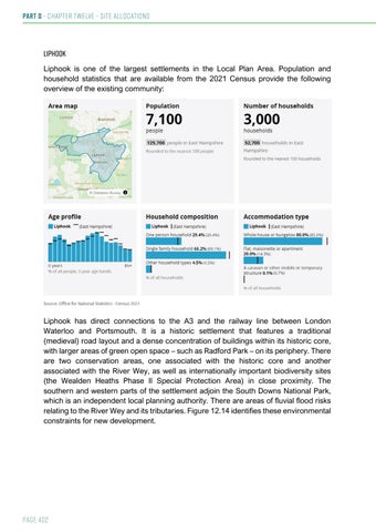
Liphook Liphook is one of the largest settlements in the Local Plan Area. Population and household statistics that are available from the 2021 Census provide the following overview of the existing community:
Liphook has direct connections to the A3 and the railway line between London Waterloo and Portsmouth. It is a historic settlement that features a traditional (medieval) road layout and a dense concentration of buildings within its historic core, with larger areas of green open space – such as Radford Park – on its periphery. There are two conservation areas, one associated with the historic core and another associated with the River Wey, as well as internationally important biodiversity sites (the Wealden Heaths Phase II Special Protection Area) in close proximity. The southern and western parts of the settlement adjoin the South Downs National Park, which is an independent local planning authority. There are areas of fluvial flood risks relating to the River Wey and its tributaries. Figure 12.14 identifies these environmental constraints for new development.
Page 402
Figure 12.14: Strategic Environmental Constraints for New Development in and around Liphook
In the revised settlement hierarchy of this Draft Local Plan, Liphook is identified as a Tier 2 settlement. This indicates that it has a relatively large range of facilities and services for meeting some of the everyday needs of local residents. Figure 12.15 identifies the number of new homes completed or permitted within Liphook since 2021, whilst Figure 12.16 highlights where current planning permissions are located within the settlement. New allocations through the Local Plan will augment the existing supply of completions and permissions to meet the overall need for new homes until 2040. Proposals for new development sites are included after Figure 12.16.
Page 403
Part d - Chapter twelve - site allocations
Figure 12.15: Housing in Liphook Type of supply
Number of homes
Completions (2021-2023)
131
Outstanding permissions (2023)
130
Proposed new allocations (to 2040)
111
Figure 12.16: Location of outstanding housing permissions and proposed sites in Liphook
Page 404
North East Area: Remaining Settlements & Site Proposals This part of the Local Plan Area forms part of the Wealden Greensands countryside character area of East Hampshire. The North East Area is typified by sandy soils and heathlands, with wooded settings to the settlements. The area’s topography is relatively flat or shallow, with occasional narrow valleys that are associated with watercourses. The settlement pattern is dispersed, with the largest settlements of Whitehill & Bordon and Liphook being located close to the South Downs National Park, whilst the smaller settlements of Headley, Headley Down and Grayshott are in close proximity to the Surrey Hill Area of Outstanding Natural Beauty. Holt Pound lies close to Alice Holt Forest, adjoining more developed areas in Waverley Borough Council’s area. The A3 trunk road and the Portsmouth-to-London railway line are the most strategically significant transport connections. Population and household statistics that are available for a ‘best fit’ area from the 2021 Census provide the following overview of existing communities:
Sites within or close to the settlements of Headley Down and Holt Pound have been identified as those preferred for development in this Draft Local Plan. Holt Pound is a small settlement located close to Farnham and adjoining the South Downs National Park. Headley Down is located between Headley and Grayshott, in close proximity to internationally important biodiversity sites (the Wealden Heaths Phase II Special Protection Area). Figure 12.30 identifies many of the principal environmental constraints for new development in the North East Area.
Page 465
Part d - Chapter twelve - site allocations
Figure 12.30: Strategic environmental constraints for the North East
In the revised settlement hierarchy of this Draft Local Plan, Holt Pound is identified as a Tier 3 settlement, whilst Headley Down is identified as a Tier 4 settlement. This indicates that there is the potential for residents to access some facilities or services within a reasonable walking or cycling distance. As such, only a small-scale of new development is likely to be appropriate within these settlements, so that the Local Planning Authority remains true to the principle of helping the residents of new development to live more locally, using walking and cycling as modes of transport more frequently. Figures 12.31 and 12.32 highlights where current planning applications are located within the wider environs of Headley Down and Holt Pound in relation to the proposed allocations. It should be noted that the proposed allocation at Headley Down is for travelling showpeople accommodation rather than housing for general needs. Details on potential new sites in Headley Down and Holt Pound are identified after Figure 12.32.
Page 466
Figure 12.31: Current Planning Applications and Proposed Allocations – Headley Down
Figure 12.32: Current Planning Applications and Proposed Allocations – Holt Pound
Page 467