PART 1 Delivering a Better Future for Hertsmere
Chapter 1 About Hertsmere’s Local Plan
1.1 This part of the emerging Local Plan will briefly set out the following introductory content. This will be prepared and included as part of the subsequent Draft Submission Local Plan that will be published for consultation under the Town and Country Planning Regulations 2012 Regulation 19.
The planning framework
How the plan has been prepared
How to use the plan
Strategic and non-strategic policies
11. Question: Do you agree with the proposed content for Chapter 1 of the emerging Hertsmere Local Plan? Yes/ No
12. Question: If you disagree, what additional content should the Chapter contain? Please set out your reasons why the Plan’s Chapter 1 should include this additional content.
Hertsmere Borough Council
Hertsmere Local Plan Draft Regulation 18 Consultation Document
Chapter 2 Hertsmere Today and into the Future
2.1 This provides the contextual information for the Local Plan. This will be prepared and included as part of the subsequent Draft Submission Local Plan that will be published for consultation under the Town and Country Planning Regulations 2012 Regulation 19. It will be comprised of the following –
Introduction
Hertsmere in context
Population
Deprivation and inequality
Heritage and character
Housing
Economy
Green infrastructure
Environment
Transport and connectivity
Health and Well-Being
Hertsmere Borough Council
Hertsmere Local Plan Draft Regulation 18 Consultation Document
13. Question: Do you agree with the proposed content for Chapter 2 of the emerging Hertsmere Local Plan? Yes/ No
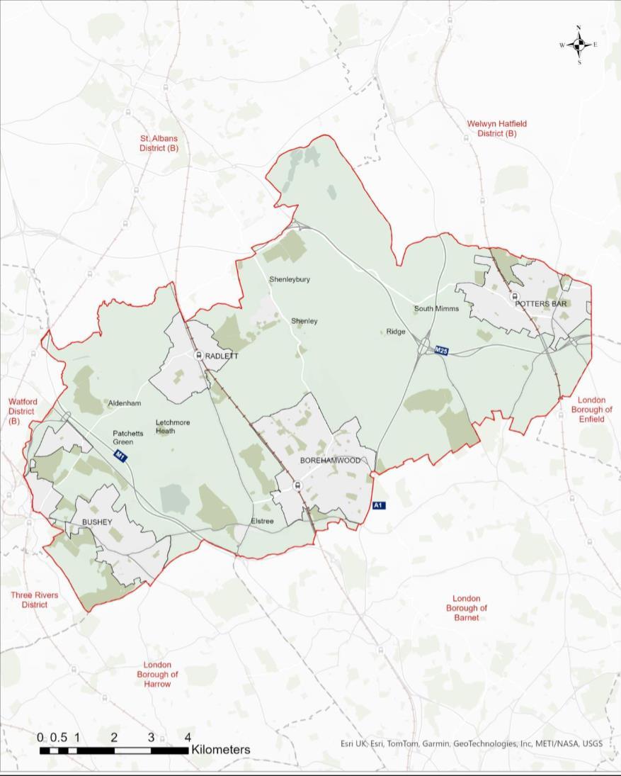
Figure 2.1: Hertsmere Borough Map
Hertsmere Borough Council
Hertsmere Local Plan Draft Regulation 18 Consultation Document
14. Question: If you disagree, what additional content should the Chapter contain? Please set out your reasons why the Plan’s Chapter 2 should include this additional content.
Hertsmere Borough Council
Hertsmere Local Plan Draft Regulation 18 Consultation Document
Chapter 3 Vision, Strategic Objectives and Spatial Strategy
3.1 This is an important part of the new Local Plan and sets out the Council’s positive vision for future growth and how supporting infrastructure will be delivered to meet needs and secure successful and sustainable placemaking -
Hertsmere’s Strategic Context
An Appropriate Spatial Strategy
Hertsmere’s Strategic Context
3.2 Hertsmere is located within the South West Herts strategic planning area, which includes the district and borough councils of Dacorum; Hertsmere; St Albans City; Three Rivers; and Watford. The councils have worked closely together over several years to plan for the long-term future of the area through the formulation of a Joint Strategic Plan. Local Government Reorganisation has meant that this work will progress once the geographies for the new strategic authorities are determined later this year.
3.3 Hertsmere also immediately adjoins the three outer London Boroughs of Barnet, Enfield and Harrow. Hertsmere’s hinterland geography remains a strategic consideration – specifically in respect of the emerging new London Plan. That latter document is seeking to meet the London’s housing needs in full. Whilst that suggests that there will not be a direct impact on the Borough, in terms of the quantum of housing it delivers, there may be other matters, such as meeting wider strategic industrial employment needs that need to be considered.
3.4 The Council is positively engaging with its neighbours within Hertfordshire and with the London boroughs to the South. That engagement process will seek to identify and confirm relevant strategic cross boundary matters that Hertsmere shares with its neighbours. It is anticipated that the outcome will
Hertsmere Local Plan Draft Regulation 18 Consultation Document
be a suite of statements of common ground, between the Council and its neighbours that set out the agreed position on relevant strategic matters and any actions that will be required. It is anticipated that this will provide appropriate and proportionate evidence that the legal requirements associated with the duty to co-operate have been met – as required by National Planning Policy and the Localism Act.
15. Question: Do you agree with the proposed approach towards meeting the legal requirements for the Duty to Co-operate in relation to strategic cross boundary matters? Yes/ No
16. Question: If you disagree, please set out the additional actions that you consider the Council needs to undertake to ensure that it meets the Legal Requirements associated with the Duty to Co-operate?
An Appropriate Spatial Strategy
3.5 National Planning Policy12 requires that to be sound a local plan will include an appropriate spatial strategy that as a minimum seeks to meet the objectively assessed needs of Hertsmere in full13 A key starting point in determining the spatial strategy for Hertsmere is understanding the current settlements and categorising them to present a settlement hierarchy This work builds upon outputs undertaken with partners across South West Hertfordshire as well as more recent studies undertaken by Hertsmere. Figure 1 below summarises the categories identified with further detail on each provided below.
12 National Planning Policy Framework (December 2024) Paragraph 36 b)
13 National Planning Policy Framework (December 2024) Paragraph 36 a).
Hertsmere Borough Council
Hertsmere Local Plan Draft Regulation 18 Consultation Document
Table 1: Summary of categories used in the South West Hertfordshire Settlement Hierarchy
Category I Settlements: Main Centres of Population
Category II Settlements: Large Towns
Category III Settlements: Small Towns
Category IV Settlements: Large Villages and Branch Line Villages
Category V Settlements: Villages
Category VI: Below Threshold Settlements
3.6 There are no Category I settlements in Hertsmere. The nearest being neighbouring settlements of St Albans and Watford. Borehamwood is classified as a Category II settlement, being classified as a Tier I Settlement. Potters Bar is Category II settlement, being classified as a Tier II settlement. It is highlighted that Bushey, with a resident population greater than Potters Bar is also classified as a Tier II settlement. However, it is noted that Bushey has no railway station14, it is reliant upon highway networks and has a less discernible centre. Radlett has the smallest resident population and is classified as a Category III/ Tier III settlement. In contrast to Bushey, it is located on a railway mainline, with good connections to central London and at least has a legible centre. It is noteworthy that London Colney, a settlement in adjoining St Albans is also classified as a Category III
14 Within Hertsmere – Bushey does have a named station that is factually located in neighbouring Watford Borough
Hertsmere Local Plan Draft Regulation 18 Consultation Document
settlement that does not have a direct connection to the railway network –and is reliant upon access via the highway network
3.7 The hierarchy identifies Shenley as a Large Village – albeit acknowledging that it has a limited range of services and facilities. Specifically, it has no secondary school and limited employment opportunities. The Borough’s remaining settlements all fall within Category V – Elstree Village and South Mimms – and Category VI below threshold settlements. These are considered unsustainable locations for development and are unlikely to meaningfully contribute to meeting Hertsmere’s future growth needs.
3.8 This approach to the Borough’s settlement hierarchy has been further assessed through technical evidence set out under Document E2 Settlement Hierarchy and Services (January 2026). The Council considers that this approach is sound.
17. Question: Do you agree with the proposed settlement hierarchy and the technical evidence that supports it? Yes/ No
18. Question: If you disagree, please set out an alternative hierarchy. Please provide a clear justification why your approach should be considered sound.
3.9 Currently the most visibly significant constraint to growth across Hertsmere, within the context of identifying an appropriate spatial strategy, is the current extent and permanence of the Green Belt. Consequently, the Council’s proposed appropriate spatial strategy responds by seeking to optimise growth and regeneration opportunities within the existing urban areas to minimise the need to release Green Belt Furthermore, in circumstances where the release of land from the Green Belt is considered necessary to ensure needs are met in full, the Spatial Strategy will seek to optimise site
Hertsmere Local Plan Draft Regulation 18 Consultation Document
capacity. This approach considers national planning policy15 and guidance16 on development densities, with the specific objective of further minimising the need to release additional land from the Green Belt in the long term.
3.10 National planning policy17 states that the Green Belt is already established. It also provides the policy context for considering proposals that impact upon its extent. For clarification, the emerging Local Plan does not include policies that are specific to the Green Belt – as this matter is sufficient addressed through national planning policy.
3.11 The plan-making process has prepared appropriate and proportionate technical evidence that assesses the Green Belt across Hertsmere. That work has included engagement with relevant neighbouring planning authorities. The technical evidence is set out under Document E1 Green Belt Study (April 2026). The Council considers that the approach to assessing the Green Belt is sound.
19. Question: Do you agree with the approach taken in assessing Hertsmere’s Green Belt? Yes/ No
20. Question: If you disagree, please set out how you believe this matter should be considered for it to be found sound. Please justify your response.
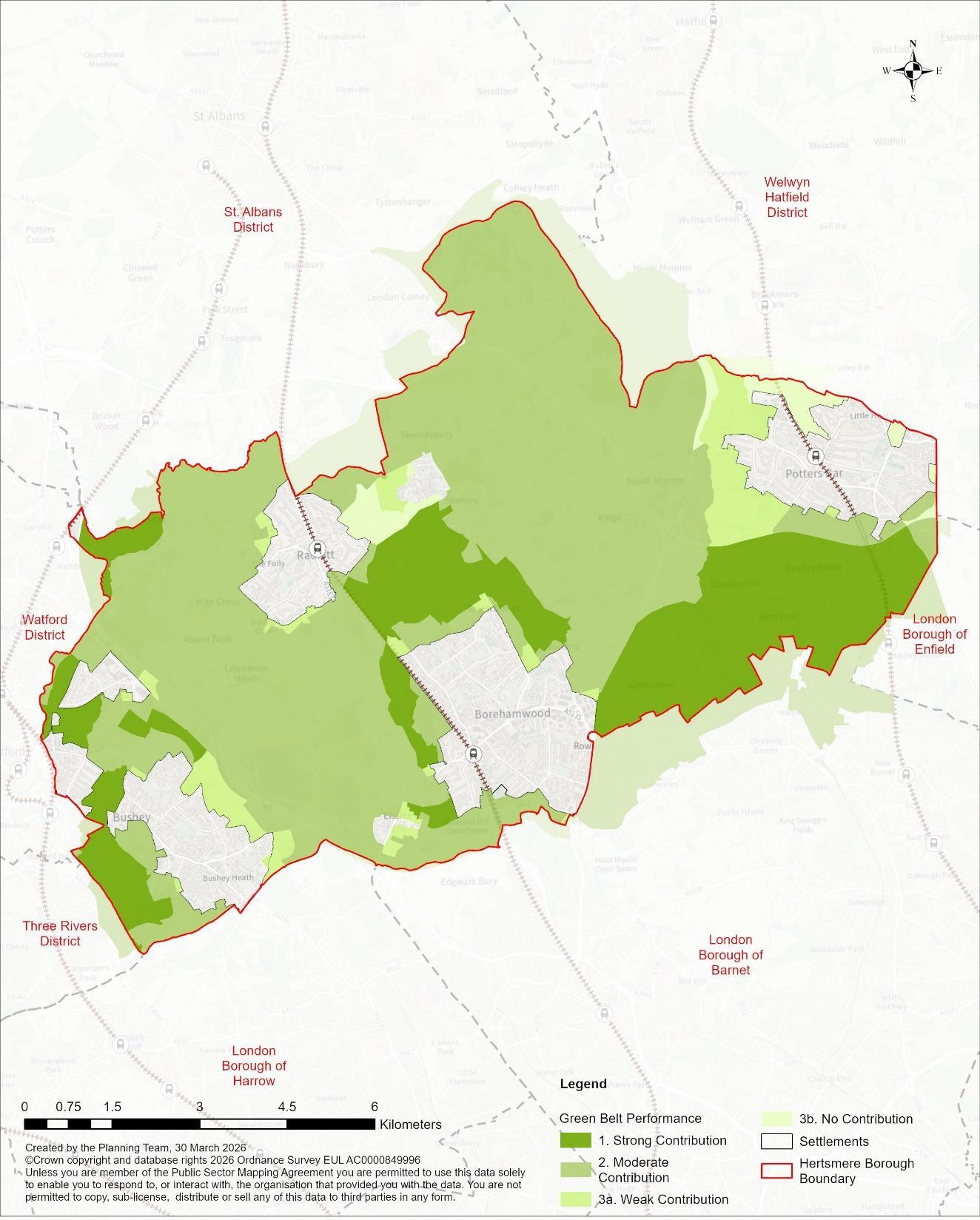
3.12 The technical evidence demonstrates that there are parts of the Borough’s designated Green Belt that perform strongly against the purposes as set out by national planning policy18. These strongly performing areas are assessed
15 National Planning Policy Framework (December 2024) Paragraph 130.
16 National Design Guide 2021.
17 National Planning Policy Framework (December 2024) Paragraph 144.
18 National Planning Policy Framework (December 2024) Paragraph 143.
Hertsmere Borough Council
Hertsmere Local Plan Draft Regulation 18 Consultation Document
through Document E1 Green Belt Study (April 2026). The technical evidence has informed the preparation of the Local Plan.
Fig 3.1 Hertsmere’s Green Belt
3.13 Connections to infrastructure networks have informed consideration on an appropriate spatial strategy. This being particularly relevant in terms of access to sustainable travel networks, with connections to higher Tier centres to the North and South (particularly London). Access to the strategic highway network, the M1, M25 and A1 (M), is a parallel consideration, particularly in terms of strategic industrial employment uses, the film industry, strategic logistics, and datacentres. Potential connectivity to the Hertsmere Local Cycling Walking Infrastructure Plan (LCWIP) investment is also a consideration.
3.14 Equally, many parts of the Borough, especially those places outside of the four main settlements, experience relatively poor levels of accessibility to key infrastructure networks. This is particularly the case in respect of access to sustainable travel networks and as such much of the Borough, outside of the four main towns, provides limited scope for genuinely sustainable placemaking.
3.15 The Council continues to work positively with infrastructure partners and the development industry to ensure that the proposals that will deliver the planned-for growth will be supported by a proportionate investment in necessary infrastructure networks. It is anticipated that this will be evidenced through statement of common ground (between the partners), technical evidence (such as transport modelling), and the infrastructure delivery plan19. The Council considers that this is a sound approach.
19 The Borough-wide Infrastructure Delivery Plan is being prepared as part of the Local Plan‘s wider technical evidence base. It will be published in support of the Regulation 19 stage of the process.
21. Question: Do you agree with the approach being taken towards infrastructure networks and their capacity? Yes/ No
22. Question: If you disagree, please set out what actions need to be taken to ensure soundness? Please justify your response.
The Spatial Strategy
3.16 The Spatial Strategy considers the Borough’s settlement hierarchy, the capacity (within settlements) to accommodate growth and existing infrastructure networks. The Strategy distributes growth in accordance with the settlement hierarchy and is also informed by an understanding of relevant constraints and land use designations. The spatial strategy envisages that most growth, specifically during the first five-years of the plan period will be distributed to the Borough’s two higher order settlements of Borehamwood and Potters Bar, with a focus upon intensification through urban regeneration.
3.17 The Spatial Strategy will seek the regeneration of the Borough’s high order settlements – through the comprehensive redevelopment of their main town centres. Both settlements have several strategic level urban site allocation opportunities – comprised of sites/uses that have or will reach the end of the lifespan during the plan period. These sites typically consist of single commercial, or social infrastructure uses that are currently developed to suboptimal densities. Examples include Borehamwood Town Centre Retail Park, several large format food stores, and several time-expired office buildings. These sites provide opportunities for town centre regeneration through their intelligent redevelopment for a complimentary mix of uses. They also provide good opportunities to secure higher design quality, green infrastructure and investment in public realm. By fully optimising their potential – through the application of appropriate verticality and high-quality design – these site allocations serve as the template/baseline for densification that could be secured through wider transformation. By
providing a focus upon the transformation and intensification of sites within existing urban areas the spatial strategy will seek to reduce the need, and consequential impact, to release greenfield sites from the Borough’s Green Belt.
3.18 In addition, the Strategy will bolster supply and delivery from new strategic urban extensions, and smaller-scale urban extensions that surround and immediately adjoin Borehamwood and Potters Bar. These will be physical extensions to the two settlements, the largest of which will be comprised of a mix of residential, main town centre, employment, open space, green infrastructure and travel networks. These new communities will functionally link and support wider regeneration within the two settlements. They will build upon the intensification being achieved elsewhere – having an appropriate mix of densities – with their centres developed at heights and densities proportionate to their status. The Council’s own evidence suggests that these types of site allocation could deliver a complementary mix of uses and infrastructure at development densities of at least 23 units/ per ha (gross). This being consistent with similar development sites being delivered elsewhere in the East of England. These urban extensions should look forward towards development typologies that will be required at their point of delivery – anticipated to be between years 6 – 15 of the plan-period. It is anticipated that these site allocations will be delivered in parallel with strategic urban site allocations and will collectively deliver the step-change in growth required for Hertsmere.
3.19 The Strategy considers that the Borough’s remaining two settlements, Radlett and Bushey would take a lesser level of growth – in the form of smaller scale urban extensions and intensification through windfall and infill development. This would reflect the typologies found within those settlements – low density and high value properties arrayed in a suburban/ commuter-belt townscape – and their limited range of main town centre uses and community facilities. Both settlements could consider modest urban
Borough Council
extensions that could also begin to progressively intensify their respective development typologies – through future windfall development.
3.20 The Strategy could also support a new settlement that could begin to deliver growth later in the plan period and continue into the next. This option could exploit an opportunity provided by land to the east of London Colney, which is itself located in the adjoining St Albans City. The Strategy could consider this opportunity as a source of strategic housing supply, as an important delivery vehicle that sustains the step-change in housing (supply and delivery) well into the next plan period and secures significant infrastructure network and capacity improvements. It could also serve to define the extent of the Green Belt in the longer term – along the southern extent of St Alban’s and east of what is currently London Colney. That new boundary could be maintained in permanence by the delivery of new accessible strategic open space and/ or strategic ecological designations.
3.21 The Strategy considers the remainder of the Borough – specifically the smaller rural settlements (such as Shenley) - as being inappropriate and unsustainable locations for growth/ place-making during the plan period. The strategy explicitly seeks to protect these places from inappropriate levels of growth by directing it to the places set out above. The possible exceptions to this approach could be single infill dwellings, delivered as self or custom build housing; and/or rural exceptions sites that deliver affordable housing that meets specific local needs. Major housing proposals (ten or more units) will be strongly resisted this is specifically the case with specialised forms of housing – elderly person accommodation and co-living – which must be located within existing urban areas, where they will benefit from access to existing infrastructure networks.
3.22 A further possible exception could arise where a proposal seeks to justify itself based on improving housing delivery. Such circumstances could occur during years 1 – 5 of the plan-period. When such opportunities arise, the
Council will require that such proposals demonstrate extremely robust evidence that delivery will take place, and make a meaningful contribution to performance, during the first three years of the proposal’s consent20. This is a high bar for proposals to cross.
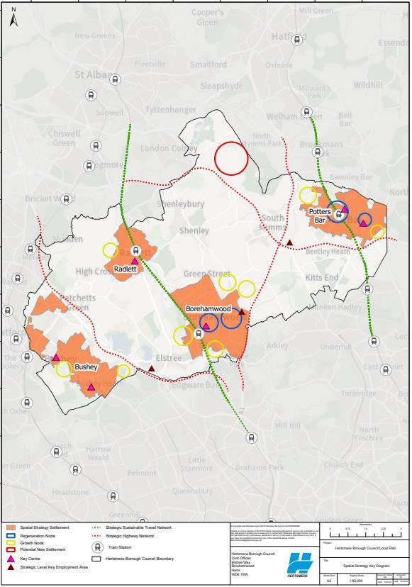
3.23 The Spatial Strategy will be expressed through a Key Diagram. This will identify the four settlements towards which future growth will be directed. It further illustrates how growth will be delivered by identifying the broad locations of regeneration nodes, for example Borehamwood Town Centre and Elstree Way, and growth nodes, the latter broadly equating to the location of future site allocations. The Diagram will also identify key centres21 , strategic employment locations, and the strategic sustainable travel and highway networks that connect the Borough’s places A Key Diagram is included below for illustrative purposes. It identifies the anticipated locationsfor the Borough’s Regeneration Nodes. It has assumed possible locations for Growth Nodes. For clarity, these locations will only be finalised once the emerging Local Plan’s site allocations have confirmed following the current consultation.
20 For clarity, the Housing Delivery Test measures performance over a three-year reporting period. Most consents will have a three year lifespan, during which commencement must begin. Consequently, for a consent to have a meaningful positive impact on performance, it must deliver at scale within its first three years (following consent). This approach seeks to encourage commencements that rapidly progress to delivery at scale.
21 For clarity, these are where the Borough’s main town centre uses, as defied under Use Class E, are located.
Hertsmere Borough Council
Hertsmere Local Plan Draft Regulation 18 Consultation Document
3.2: Spatial Strategy Key Diagram
Figure
23. Question: Do you consider the proposed spatial strategy for Hertsmere, an appropriate strategy that will deliver successful and sustainable place making; planned-for growth; meet the Borough’s development needs; and necessary infrastructure investment during the plan period? Yes/ No.
24. Question: Do you have an alternative spatial strategy that could be appropriate for Hertsmere, which will demonstrably deliver successful and sustainable place making; planned-for growth; meet the Borough’s development needs; and secure necessary infrastructure investment during the plan period? Please provide details of your alternative appropriate strategy. Ensure that your response is justified by proportionate evidence.
Reasonable Alternatives
3.24 The emerging Local Plan’s Sustainability Appraisal process will test reasonable alternatives. A Sustainability Appraisal of the proposals set out in the Consultation Document forms part of the plan preparation process under Regulation 18 and is also open to consultation.
3.25 The proposed Spatial Strategy does lend itself to a degree of further evolution. These possible paths could be considered as reasonable alternatives for the purpose of Sustainability Appraisal.
3.26 The most noteworthy of these alternatives is that provided by the new town opportunity, at London Colney/Bowmans Cross. Specifically, if the site were to begin to come forward and deliver new homes at scale earlier in the plan period it could serve to accelerate housing delivery, either comfortably securing the Borough’s housing requirement early or providing a modest uplift during the plan period. This uplift in supply, delivery and intensification could be further enhanced (and ensured) through the early delivery of necessary supporting community infrastructure at the site of the new town.
Hertsmere Local Plan Draft Regulation 18 Consultation Document
This is specifically the case in terms of improved sustainable travel network connectivity between the new town, St Albans and Potters Bar. It is highlighted that this could provide an opportunity for higher densities to begin delivery early in the process – rather than waiting for a critical mass point to be reached.
3.27 A further reasonable alternative could arise in respect of how growth is delivered in Bushey. Future growth in Bushey could focus upon improving connectivity to the infrastructure networks available in neighbouring Watford, such a relationship could allow the settlement to grow as a satellite serving the Category I settlement to its immediate northwest. Higher levels of growth at Bushey could serve to fuel investment in necessary sustainable travel connections into and out of Watford. Given the apparent readiness of many of the urban extension opportunities that surround Bushey, this reasonable alternative could deliver at scale during years 6 – 10 of the plan-period.
25. Question: Do you agree that the proposed spatial strategy could enable the two reasonable alternatives identified above? Yes/ No.
26. Question: Are there any other reasonable alternatives that could arise during the delivery of the proposed spatial strategy?
PART 2 Managing Development (Planning Policies)
Chapter 4 High Quality Design
4.0 The following chapter sets out the policies that the Council will deploy to secure delivery of new development that meets the requirements of highquality design. Securing high-quality design, a key component of successful and sustainable place-making. It is set out as a key requirement in National Planning Policy22 .
Policy HQD1 Delivering High Quality Design in Hertsmere
4.1.1. An overarching strategic policy that sets out the requirements for all development to take the design-led approach to delivering growth – to secure sustainable and successful places. It is envisaged that the policy will require development proposals demonstrate an understanding of the site context and respond positively to Hertsmere’s local distinctiveness by providing for buildings, spaces and places that reinforce and enhance local character. The policy will include a series of criteria that will require that development proposals respond to local distinctiveness.
4.1.2. The policy will also include requirements to ensure that all development is designed to ensure that they result in places that are inclusive, wellfunctioning and resilient. The policy will ensure that high quality design considers and secures integration with infrastructure networks from the outset. The policy will work with others in the emerging Local Plan and require that new development mitigate the impact of climate change.
22 National Planning Policy Framework (December 2024) Paragraph 131.
4.1.3. The policy will require, where appropriate, that development proposals must include a Design and Access Statement to demonstrate how the design-led approach has been applied to deliver high quality development.
Policy HQD2 Inclusive and Welcoming Design
4.2.1. A non-strategic policy that seeks to secure welcoming and inclusive built environment. The policy will require that an Inclusive Design Statement should form a component of a Design and Access Statement. This will be proportionate to the scale of the development being proposed. This should demonstrate how the design of a scheme will contribute to delivering inclusive, accessible, welcoming and secure environments in Hertsmere, addressing disproportionate barriers.
4.2.2. Development proposals will be required to respond positively to the diverse and varied needs of Hertsmere’s population and promote social cohesion. The policy will include a series of criteria that proposals will need to demonstrate that they have met, by demonstrating a proactive approach to inclusive design based on safety and perception of safety; ease of movements; provision of social infrastructure; play and recreation for all.
4.2.3. The policy will also seek to secure accessible and inclusive homes that are tenure neutral. It will seek to ensure that proposals meet national design standards, in addition to Building Regulation requirement M4(3) ‘wheelchair user dwellings’; and for all other dwellings meet Building Regulation requirement M4(2) requirements for accessible and adaptable dwellings. The whole-plan viability assessment considers this possible requirement.
4.2.4. The policy will take a positive approach to proposals that seek to adapt historic buildings, subject to them demonstrating how they preserve or enhance the significance of the asset and their setting.
Policy HQD3 Public Realm and Connecting Places
4.3.1. This non-strategic policy sets out the requirement for the delivery of public realm through new development, to secure high quality and well-connected public spaces. The policy would seek to integrate new developments within existing settlements, creating connections to existing communities
4.3.2. Where strategic, major, or sensitive developments are proposed, the development proposals will be required to demonstrate how successful placemaking is achieved and indicate compliance with the settlementspecific ‘Visions’ where relevant.
4.3.3. The use of a design-led approach would be essential to ensure the development respond to the public realm, creating legibility and permeability, while reducing the dominance of vehicular movements.
4.3.4. This policy also seeks to incorporate public art, where possible in major developments, subject to considerations set out within the policy.
Policy HQD4 Building Heights
4.4.1. A strategic policy that will be linked to the Council’s proposed Spatial Strategy and set out the approach towards tall buildings. This policy will set out:
The definition of tall buildings within the Hertsmere context, we anticipate that within Hertsmere a tall building will defined as one with ten storeys or more
Identified locations where tall buildings might be considered appropriate
Relevant design parameters in terms of maximum heights and highquality design.
4.4.2. The policy will seek to ensure that efficient use of land within settlement boundaries is achieved, delivering intensification in appropriate locations, while also ensuring that places remain legible, welcoming, inclusive and accessible. The Local Plan will include maps that identify the most appropriate locations for new tall buildings. This will take account of the spatial strategy’s approach towards urban regeneration; the availability of sites; the capacity of infrastructure networks; accessibility to sustainable travel networks; and the ability for the surrounding townscape to accommodate this form of intensification in terms of impact on its character and appearance.
Policy HQD5 Optimising Site Capacity
4.5.1. This strategic policy sets out the Council’s ambition to achieve optimal site capacity, specifically in relation to development located within existing settlements. Proposals will be expected to respect the character of the area, while using land supply resources effectively and efficiently to accommodate growth. Optimum capacity will derive through careful consideration of density, uses, transport links, and existing and future infrastructure provisions. It will work alongside other policies that seek to secure urban regeneration; the efficient use of development sites; and secure high-quality design.
4.5.2. It is assumed that the Borough’s larger settlements, such as Borehamwood and Potters Bar, will have greater capacity to accommodate higher densities, whereas rural locations will have less capacity.
4.5.3. This policy will be supported by the settlement Visions.
Policy HQD6 High Quality Housing Design
4.6.1. This non-strategic policy seeks to secure high quality design for new residential developments in the Borough. It will ensure that all new housing is designed to a high-quality standard, responding to the needs of Hertsmere’s resident population
Borough Council
Local Plan Draft Regulation 18 Consultation Document
4.6.2. The policy will set minimum internal and external space standards, and secure ‘tenure neutral’ design. It will also set out requirements for internal and external amenity, such as:
Daylight & sunlight
Natural ventilation
Outlook
High quality amenity spaces
Policy HQD7 Building Alterations and Extensions
4.7.1. This non-strategic policy will seek to secure high-quality design from householder development, and other development involving alterations and extensions to existing buildings that require consent. The policy will set out key considerations for extensions, alterations and basement developments to ensure that such proposals will make a positive contribution to the local character, particularly on buildings of historic interest, within Conservation Areas, and established residential areas.
4.7.2. The policy will manage the quality of improvements, going beyond the permitted development regime. It is anticipated that a Planning and Design Guide Supplementary Planning Document (SPD) will be prepared during the plan period to support the delivery of this policy.
4.7.3. Extensions or alterations to existing dwellings will be expected to make a neutral or positive contribution to the surrounding area, and overbearing development will be resisted. The policy will also protect residential gardens from overdevelopment
Hertsmere Borough Council Hertsmere Local Plan Draft Regulation 18 Consultation Document
Policy HQD8 Infill and Backland sites, Garden Land and Amenity Areas
4.8.1. A non-strategic policy that works in harmony with other policies that focus upon delivery on small sites and seek their efficient use. The policy approach compliments a potential strategic approach to minimise the degrading of the Borough’s Green Belt, in terms of securing efficient use of supply.
4.8.2. This approach also speaks to diversifying supply/delivery, so that Hertsmere is not solely dependent upon strategic sites for its future housing.
Policy HQD9 Shopfront Design
4.9.1. A non-strategic policy that seeks to secure high quality design for ground floor main town centre and/or commercial uses. Proposals will be expected to reflect local distinctiveness, reinforcing a sense of place, and ensure legibility.
4.9.2. The policy will relate to new shopfront and alterations to existing ones, ensuring that development does not result in adverse impact on character, amenity or public safety.
Policy HQD10 Outdoor Advertisements, Digital Displays and Hoardings
4.10.1. A non-strategic policy that seeks to manage proposals for outdoor advertisement, digital displays and hoardings. Proposals that are beyond the scope of permitted development will be evaluated based on design characteristics, and any potential impact on amenity and public safety.
4.10.2. This policy will also seek to control illuminated advertisement within Conservation Areas.
Borough Council
Hertsmere Local Plan Draft Regulation 18 Consultation Document
Chapter 4 Questions:
27. Question: Do you agree with the content set out within policies HDQ1HDQ10 regarding the Council's proposed approach towards securing High Quality Design across the Borough? Yes/No.
28. Question: If you disagree with any of the content, with reference to specific policies, please provide detailed comments or suitable alternatives, and justify your answer with appropriate and proportionate evidence.
Chapter 5 Heritage
Policy HE1 Hertsmere’s Historic Environment
5.1.1. A strategic policy that provides an overarching approach towards Hertsmere’s heritage assets and their role within the spatial strategy, in continuing to contribute towards the Borough’s character and distinctiveness.
5.1.2. The policy will set out how future development will preserve or enhance the value and significance of Borough’s historic environment and its setting. It will set out how the Council, acting as local planning authority will work with partners to identify, assess, monitor and review heritage assets and understand their importance to both the Borough and the nation.
5.1.3. It will celebrate Hertsmere’s heritage assets and environments, ensuring that they play a central role in reinforcing sense of place and place making, particularly in meeting needs, securing high quality, successful and sustainable places. In this respect it will promote heritage-led regeneration and urban renewal to retain, reveal or reinstate significant aspects of the Borough’s historic environment.
5.1.4. The policy will also set out the requirements for development, in terms of assessing historic environments and in respect of possible impacts on heritage assets The policy will require developers to submit a Heritage Statement as part of their proposals. These will be required to describe the significance of any heritage assets affected, and the contribution made by their setting; set out how the historic environment has informed the design of the proposal; and assess the impact of the proposal on the relevant assets.
Policy HE2 Designated Heritage Assets
5.2.1. This strategic policy will set out the Council’s approach towards the management of heritage assets, and their contribution towards Hertsmere’s future growth. The policy will be subdivided into sections in relation to:
conservation areas;
listed buildings;
registered parks and gardens; and
scheduled monuments.
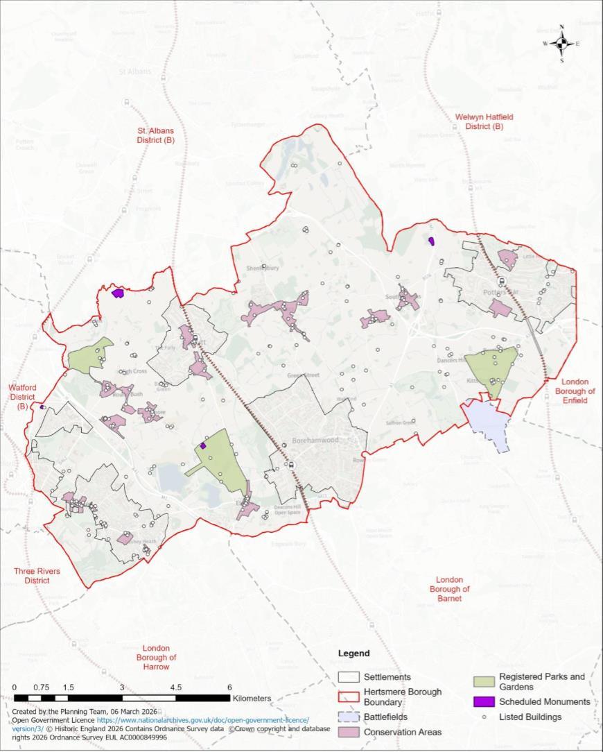
5.2.2. The policy will consider the impact of development proposals on designated heritage assets. For clarification, the Council proposes that the policy will consider the cumulative impact of development upon Conservation Areas. It will also seek the retention of buildings and structures that have been assessed and determined as making a positive contribution to the significance of a Conservation Area.
5.2.3. As part of the Council’s sustainable place-making, this policy would seek to ensure that the Council’s heritage assets are managed and adapted in ways that would minimise harm.
Hertsmere Borough Council
Hertsmere Local Plan Draft Regulation 18 Consultation Document
Figure 5.1: Designated Heritage Assets
Hertsmere Borough Council
Hertsmere Local Plan Draft Regulation 18 Consultation Document
Policy HE3 Non-Designated Heritage Assets
5.3.1. This strategic policy sets out the approach towards the Borough’s nondesignated heritage assets in relation to their management, and their contribution towards Hertsmere’s future growth. This policy will be accompanied by a map identifying their location. The policy also provides an opportunity to set out how future non-designated heritage assets will be identified and “designated”.
Chapter 5 Questions:
29. Question: Do you agree with the content set out within policies HE1-HE3 regarding the Council's proposed approach towards the management of Hertsmere's heritage assets and historic environment? Yes/No.
30. Question: If you disagree with any of the content, with reference to specific policies, please provide detailed comments or suitable alternatives, and justify your answer with appropriate and proportionate evidence.
Chapter 6 Housing
Policy H1 Meeting Hertsmere’s Housing Need
6.1.1. A strategic policy that sets out what Hertsmere’s future housing need is and how the subsequent local plan policies, settlement and place policies, and site allocations will meet those needs in full. The policy could consider how the Council will discharge its responsibilities in the process, particularly in maintaining a rolling five-year housing land supply, granting consents in a timely manner, and facilitating high quality growth that meets needs. In return, the development industry can be reasonably expected and held to account to deliver consented schemes in a timely manner, at an appropriate speed that ensures that consents positively contribute towards the Housing Delivery Test measurement. The Council will deploy those measures available to local planning authorities to ensure that consented schemes are delivered and contribute towards meeting needs as anticipated in a timely manner. Failure to meet those reasonable expectations could be considered as a material consideration in relation to future proposals. The Council could apply this approach when considering proposals to renew previously consented proposals that the industry has failed to deliver in a timely manner.
Policy H2 Hertsmere’s Urban Extensions23
6.2.1. It is anticipated that the Hertsmere Local Plan will be positively prepared and will meet the housing requirement in full. To meet this objective the emerging Local Plan will identify a sufficient supply of deliverable and developable sites that meet need and ensure that there is at least a demonstrable fiveyear housing land supply at the point of adoption. By allocating sufficient
23 For clarification this policy proposal relates to schemes on unallocated sites.
Borough Council
Hertsmere Local Plan Draft Regulation 18 Consultation Document
sites to meet need and maintain a rolling five-year housing land supply, the approach seeks to discourage speculative development that would result in the further release of Green Belt. However, despite this approach it is possible that speculative proposals, such as those currently being promoted through the development management process, will continue to come forward. These proposals could constitute new urban extensions, namely major development that extends existing main settlements, beyond the extent proposed through the Local Plan’s site allocations.
6.2.2. This strategic policy will set out how the Local Plan’s approach is to intelligently direct and plan-for growth towards the four towns that have the capacity to accommodate major development. Major development proposals relating to the Borough’s other settlements will be strongly resisted. This approach seeks to make optimal use of the allocated urban extension to ensure that the need for any further release of land from the Green Belt is minimised. This approach aligns with the spatial strategy and is supported through technical evidence
6.2.3. The policy will set out how the Council has carefully considered, assessed and discounted other sites that could potentially have been released from the Green Belt. The policy will explicitly state that future speculative proposals seeking to release other designated Green Belt sites, solely as urban extensions, will be resisted. The possible exception could be in circumstances where a proposal is demonstrably sustainable in terms of access to sustainable travel networks, infrastructure and high-quality design (among other policy requirements).
6.2.4. Proposals that could also demonstrably deliver additional homes in a timely manner24 that would result in an improved Housing Delivery Test
24 For Housing Delivery Test purposes, it is reasonably assumed that timely delivery will equate to a period of three years from the date of a proposal receiving consent. This is justified on the basis that
Hertsmere Borough Council
Hertsmere Local Plan Draft Regulation 18 Consultation Document
measurement performance could also be positively consider – subject to meeting relevant policy requirements. In those circumstances, consented proposals will be carefully monitored, be required to submit delivery timetables, and will have financial penalties imposed if they fail to deliver in accordance with agreed milestones. Possible use of CIL to leverage timely delivery, for example applications to use Phase 0, or phased payments will not be positively considered25
Policy H3 Optimising Delivery from Small Urban Sites
6.3.1. A new strategic policy that seeks to optimise the efficient delivery of small sites, ostensibly within the four designated settlements and smaller settlements. The policy seeks to secure the delivery of high-quality development on these sites. For clarification, it relates to the delivery of new homes, rather than extensions to existing properties. The policy will work alongside complementary approaches that secure design quality. This source will further diversify supply across the Borough and ensure that there is not a reliance upon large strategic sites for delivery. The policy will set out how SME developers, on small sites, will contribute towards making the step-change in delivery – and how the Council will help them do so. The policy will also seek to minimise the need to release designated Green Belt land to deliver the Borough’s housing need.
6.3.2. The policy will refer to the types of small urban site that would be positively considered, and it will have links to other relevant housing and design
the Test monitors developer performance over a rolling three period. Consequently, delivery within three years of consent can reasonably be assumed to positively influence performance.
25 These are examples of circumstances where developers seek to delay payment of CIL, despite having commenced work on-site.
Hertsmere Local Plan Draft Regulation 18 Consultation Document
policies. This includes the application of national space standards as a key component of secure quality development.
6.3.3. The Council intends to prepare a Supplementary Planning Document (SPD) during the plan period that will set out further guidance for small site development. The purpose of the Document will be to set out the Council’s expectations and provide some level of certainty for applicants.
6.3.4. The Local Plan will include a map that identifies possible small site opportunities across the Borough’s settlements. These align with the spatial strategy’s focus upon urban regeneration and intensification. The proposed SPD could explore the approaches and interventions the Council could use to deliver these sites during the plan-period.
Policy H4 Delivering Genuinely Affordable Housing
6.4.1. This strategic policy sets out the scale of affordable housing need across the Borough and how it will be met going forward. Namely, the percentage of new affordable homes being secured through new development. This will need to recognise and reflect development viability, identifying what percentage of new affordable provision can be supported without endangering delivery of new homes.
6.4.2. It is proposed that the policy takes a pragmatic approach towards meeting the acute need for new genuinely affordable homes, so as not to prejudice the delivery of new homes in totally. Consequently, the policy proposes to identify a requirement that proposals for 10 dwellings and more deliver at least 30% genuine affordable housing. It is noted that Document E3 Local Housing Needs Assessment, which forms part of the Local Plan’s technical evidence base, identifies a higher requirement. The policy will define what is meant by genuinely affordable housing, and how it will be the focus for delivery.
Borough Council
6.4.3. The policy will place emphasis on on-site delivery of affordable housing on major sites, unless exceptional circumstances are demonstrated. Alternatively, a cascade approach could be used where it is not possible to deliver on-site affordable housing, prioritising off-site delivery on an alternative site, or a final option for a payment in lieu.
Policy H5 Accommodation for Older People
6.5.1. A non-strategic policy that sets out the approach to the delivery of accommodation for older people. This policy will set the overall target, or percentage of provision as established against the overall housing need. Where appropriate it will refer to available technical evidence and identify the specific forms of accommodation26 that are required to meet local needs. The policy will recognise that specialised accommodation for older people forms part of a wider diverse mix of typologies, which includes conventional housing that has been adapted to meet their needs.
6.5.2. The policy will be linked to the spatial strategy and clearly signal the most sustainable locations for new accommodation, primarily within Borehamwood and Potters Bar, and development of this type in other parts of the Borough will be resisted.
Policy H6 Supported and Specialised Accommodation
6.6.1. A non-strategic policy that seeks to secure supported and other forms of specialised accommodation that offers respite and provision of care or support for individuals with distinct needs, particularly those from more vulnerable groups, whether for temporary stays or longer-term periods. This
26 For example, specific identified need for close or extra care, and end-of-life accommodation.
Hertsmere Borough Council
Hertsmere Local Plan Draft Regulation 18 Consultation Document
will be subject to supporting evidence identified through the Local Plan supporting studies.
6.6.2. This policy works in tandem with the Council’s affordable housing policy. It will set out the scale of need, and what will be required to secure high quality supported and specialised accommodation that meets the Borough’s specific needs.
Policy H7 Housing with Shared Facilities/ Homes in Multiple Occupation
6.7.1. This non-strategic policy provides an opportunity for the new Local Plan to manage HMO provision, and other forms of shared housing (co-living) that may manifest itself in Hertsmere during the life of the Plan. Such forms of housing offer a degree of flexible housing options, especially considering in the context of Hertsmere’s housing delivery.
6.7.2. This policy provides an opportunity to manage provision to meet genuine needs, while managing any potential impact affecting the amenity of surrounding residential areas. Such proposals will be supported subject to meeting specified requirements that will be set out within the policy wording, relating to space standards, amenity spaces, share facilities, residential amenity, and impact on the wider area.
Policy H8 Self and Custom Build Housing
6.8.1. A non-strategic policy that sets out how the Council will identify need for this highly specialised area of housing, by setting out the monitoring process through the self and custom build register, while also aligning such housing provision with the requirements of the CIL regime. As such, self-builders will be expected to satisfy the requirements of the exemption process.
6.8.2. The policy could link into several other related policies, such as affordable housing; small site optimisation; and possible gypsy and traveller accommodation.
Borough Council
Policy H9 Gypsy and Traveller Accommodation
6.9.1. This non-strategic policy sets out the Council’s approach towards meeting Gypsy and Traveller Accommodation need. The policy will set out the target, and which period(s) that it will covers, while also setting out how it relates to national requirements for meeting the needs of the community. The scale and nature of need is assessed through an up-to-date assessment that is set out under E3a Gypsy & Traveller Accommodation Assessment Report.
6.9.2. The Council is seeking to meet identified needs in full. To meet the needs of the local communities, the Council is exploring a range of possible complementary approaches that would provide a diverse supply of provision. This could include the expansion of existing sites where there is capacity; providing flexibility for intensification within existing sites – specifically to provide accommodation for teenage members of the community; the regularisation of unlawful sites that have become established; the provision of multiple smaller sites that could meet the needs of individual family groupings; and the ability to consider speculative proposals for privately owned and managed sites. The Council is preparing a further piece of technical evidence that seeks to “leave no stone unturned” in identifying possible sources of supply required to meet needs during the plan-period. That evidence will inform the Submission version of the Hertsmere Local Plan that will be published under Regulation 19. There will be opportunities for participants to engage with the resulting policy approach, and its technical evidence.
6.9.3. This policy will have regard to wider strategic issues around this area of need, and give due consideration to transit, and temporary accommodation, inclusive of any discussions or decisions that may be taken with Duty to Cooperate partners.
Borough Council
Hertsmere Local Plan Draft Regulation 18 Consultation Document
Policy H10 New Homes in the Countryside/ Green Belt
6.10.1. This non-strategic policy will relate to speculative small-scale proposals for new homes across the wider Green Belt – inclusive of those settlements that are within the Green Belt. Speculative development in such locations will only be supported where proposals can demonstrably delivery additional new homes in a timely manner that respond to the Borough’s Housing Delivery Test measurement. In those cases, the Council may consent schemes that demonstrably meet identified needs but will judiciously monitor their timely delivery. Schemes that fail to deliver in a timely manner, and expire, will need to robustly demonstrate that they are subsequently genuinely deliverable and will meaningfully contribute towards improved performance to secure a renewed consent.
Chapter 6 Questions:
31. Question: Do you agree with the content set out within policies H1-H10 regarding the Council's proposed approach towards meeting Hertsmere's housing need? Yes/No.
32. Question: If you disagree with any of the content, with reference to specific policies, please provide detailed comments or suitable alternatives, and justify your answer with appropriate and proportionate evidence.
Hertsmere Borough Council
Hertsmere Local Plan Draft Regulation 18 Consultation Document
Chapter 7 Economy & Culture
Policy EC1 Meeting Hertsmere’s Economic Needs
7.1.1. A strategic policy that links to the spatial strategy and speaks to how Hertsmere’s employment needs will be delivered over the plan period. The policy will set Floorspace targets that will meet future needs. These identify the scale of need under the employment uses delivered through Use Classes B2, B8 and Class E (g) (i)27 . The scale of future need is identified and confirmed through Document E4 – Economic Study.
7.1.2. The Table below sets out the employment floorspace needs over the plan period.
Table 7.1: Floorspace requirements (sqm), 2025-2041 – Labour demand
27 These are respectively defined as General Industrial (B2); Storage and Distribution (B8); and office, reserach and development, and industrial processes (Class E (g) (i), (ii) and (iii)).
Hertsmere Borough Council
Hertsmere Local Plan Draft Regulation 18 Consultation Document
Source: Hertsmere Economic Study 2026
7.1.3. Technical evidence demonstrates that based on employment forecasts, by 2041 there would be a gross requirement for 56,200 sqm, including:
+15,300 sqm of E(g)(i) floorspace;
+200 sqm of E(g)(ii) floorspace;
-13,300 sqm of E(g)(iii) floorspace;
-1,700 sqm of B2 floorspace; and
+29,200 sqm of B8 floorspace
7.1.4. In addition to this, the evidence identifies a need for 954 sqm of additional film-industryfloorspace in Hertsmere, and between 52,024 sqm and 118,912 sqm of additional floorspace for data centres.
7.1.5. Employment priorities are:
Maintaining Hertsmere’s key role in the international film and television industry;
Meeting the need for future B8 logistic uses and ensuring that complement wider demands generated by businesses in the Greater London area;
Secure an improved understanding of the role and future need for data centres within London and East of England Regions;
Meeting settlement-specific, place-focused needs, which may be ancillary/ complementary to the film industry.
Hertsmere Borough Council
Hertsmere Local Plan Draft Regulation 18 Consultation Document
Policy EC2 Hertsmere’s Employment Land Hierarchy
7.2.1. A strategic policy that sets out an employment land hierarchy for the Borough. It will:
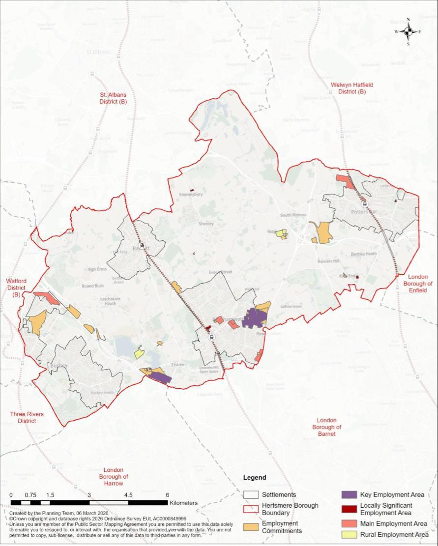
identify and map the key sites within the hierarchy, including their relationship with the strategic highway network
set out the forecast need for employment land across the borough, broken down by Class E(g) office and light industrial, Class B2 industrial, Class B8 storage and distribution, and related Sui Generis uses.
be used as a basis for decision-taking in terms of how the identified need will be met.
Table 7.2: Hertsmere's proposed designated Employment Areas
Classification Location
Key Employment Areas
Centennial Park, The Waterfront and Lismirrane Industrial Estates, Elstree
Elstree Way, Borehamwood
Sky Elstree
South Mimms Motorway Services
Main Employment Areas
Locally Significant Employment Areas
Stirling Way, Borehamwood
Tylers Way, Bushey
Cranbourne Road, Potters Bar
Station Close, Potters Bar
Otterspool Way, Bushey
Imperial Place, Borehamwood
BBC Elstree
Elstree Studios
Borehamwood Enterprise Centre, Borehamwood
Theobald Court, Borehamwood
Hollies Way Business Park, Potters Bar
Farm Close, Shenley
Beaumont Gate, Radlett
Hertsmere Borough Council
Hertsmere Local Plan Draft Regulation 18 Consultation Document
Rural Employment Areas
Wrotham Business Park, between High Barnet and Potters Bar
Bio Products Laboratory, Elstree
The National Institute for Biological Standards and Control, Ridge
Clare Hall Laboratories, Ridge
Hertsmere Borough Council
Hertsmere Local Plan Draft Regulation 18 Consultation Document
Figure 7.1: Employment land hierarchy
Policy EC3 Delivering High Quality Employment Sites and Workspaces
7.3.1. This non-strategic policy seeks to secure high quality workspaces that respond to and meet the Borough’s identified employment needs and the floorspace requirements set out in Policy EC1. The policy will set out criteria that development proposals will be required to meet. These will be based on the available evidence in Document E4 Economy Study and viability tested to ensure policy requirements do not compromise delivery of new workspaces. The policy will seek to secure design-led interventions that are appropriate and proportionate to the scale and nature of employment workspace being proposed. For clarification, the policy will seek to introduce reasonable requirements that can be delivered by new development without harming viability.
7.3.2. The policy will require the following:
basic specification, including fitting out buildings ready for use including digital connectivity, toilets, kitchens etc.;
meeting environmental impact, energy use and carbon emissions reduction requirements;
ensuring that factors such as biodiversity net gain, urban greening, SuDS and public realm are considered at the earliest stage of the development process; and
provision of flexible spaces for SMEs and startups within larger developments
Borough Council
Hertsmere Local Plan Draft Regulation 18 Consultation Document
Policy EC4 Affordable Workspace
7.4.1. This strategic policy seeks to secure an appropriate portion of affordable workspace from larger employment schemes, in line with the Council’s evidence base, as set out under Document E4 Economy Study which demonstrates a clear need for this permission It will include a formula for calculating payments in-lieu for off-site provision where provision cannot be delivered on site. The policy will be viability tested to ensure that it does not endanger the delivery of employment land.
Policy EC5 Strategic Level Employment Sites/ Designations
7.5.1. This non-strategic policy will address strategic employment sites that serve a need wider than Hertsmere alone. Sites will be identified on a policies map and will include:
Employment uses associated with the film and television industry (e.g. Sky Elstree) alongside existing large employment areas like Centennial Park, Elstree and Elstree Way, Borehamwood.
Other large scale B8 storage and logistics, data centres; and other strategic employment uses accessed or associated directly with the strategic highway network.
7.5.2. New employment uses and additional floorspace that meet identified need within the borough as well as wider regional and national need, evidenced through Document E4 Economy Study, will be directed towards these sites in line with Strategic Policy EC1
7.5.3. The policy requires that development proposals in these areas must not compromise the overall function or effectiveness of the site. Any release of vacant land within these areas for uses other than employment will be exceptional and must be supported by robust evidence.
Hertsmere Borough Council
Hertsmere Local Plan Draft Regulation 18 Consultation Document
7.5.4. The policy will consider an approach that seeks to optimise industrial employment capacity of the sites. This could be viable and justifiable based on minimising the wider impact on the strategic extent/ permanence of the Green Belt. This approach will seek to secure industrial employment intensification of use on designated sites.
Policy EC6 Local Level Employment Sites/ Designations
7.6.1. A non-strategic policy that addresses the Main Employment Areas and Locally Significant Employment Sites identified in Policy EC2. Sites will be identified on a policies map.
7.6.2. Development in these areas will:
Meet local need for Class E(g) office and light industrial, Class B2 industrial, Class B8 storage and distribution, and related Sui Generis uses, as identified through Strategic Policy EC1;
Maintain the ability of the designated area to accommodate industrial and commercial land uses by resisting the introduction of main town centre and residential uses;
Maintain the strategic position of the employment site within the Hierarchy by resisting very large warehousing and similar uses which would be better placed within Strategic Level Employment Sites; and
Potentially encourage uses that are ancillary to strategic employment uses, where these are complimentary to and do not undermine the integrity and function of the employment area, including but not limited to businesses that support the film industry. This could include the construction of props; stage sets; and costumes.
7.6.3. Any release of vacant land within these areas for uses other than employment will be exceptional and must be supported by robust evidence.
Hertsmere Borough Council
Hertsmere Local Plan Draft Regulation 18 Consultation Document
7.6.4. This policy will consider an approach that seeks to optimise/ maximise industrial employment capacity of designated sites. The approach is justified on the grounds of minimising the wider impact on the strategic extent/ permanence of the Green Belt. If such an approach is taken, it will seek to secure intensification of industrial employment use on designated sites.
Policy EC7 Rural Employment Areas
7.7.1. This non-strategic policy would seek to ensure that proposals within designated Rural Employment Areas identified in Policy EC2 and identified on a policies map will be:
In accordance with Green Belt policy
Ancillary to an existing or approved employment use; and
Compatible with the local highway network
7.7.2. Any release of vacant land for uses other than employment will be exceptional and must be supported by robust evidence.
7.7.3. This policy will consider an approach that seeks to optimise industrial employment capacity of designated sites. The approach is justified on the grounds of minimising the wider impact on the strategic extent/ permanence of the Green Belt. If such an approach is taken, it will seek to secure intensification of industrial employment use on designated sites.
Policy EC8 Co-Located/ Mixed-use Employment Sites/ Designations
7.8.1. A non-strategic policy that speaks to mixed-use sites and proposals that incorporate commercial Class E (g) uses at the ground and lower floors. The policy is related to Policy EC6 in that the new mixed-use employment sites could include Class E (g) components that contribute towards meeting local needs and supporting wider strategic needs – this could be particularly the case in respect of ancillary employment uses that support the film industry
Hertsmere Borough Council
Hertsmere Local Plan Draft Regulation 18 Consultation Document
and possibly datacentres. The policy will be informed by the Visions for the four settlements, which may identify locations for such mixed-use redevelopments.
7.8.2. The policy will also reference larger site allocations where new mixed-use development could, where it is robustly demonstrated, secure new local centres; providing a wider mix of Class E uses that is inclusive of main town centre uses.
7.8.3. The policy will seek to secure high quality provision on ground and lower floors that meets identified needs and is complimentary and compatible with the residential uses above.
7.8.4. The policy could consider whether an approach that seeks to optimise/ maximise industrial employment capacity of the sites is taken. It is suggested that this could be a viable and justifiable approach – on the basis that as per the approach to housing sites, the Council is seeking to minimise the wider impact on the strategic extent/ permanence of the Green Belt. This approach will seek to secure industrial employment intensification on appropriate sites.
7.8.5. The policy will identify where these sites are, possibly cross-referencing to the spatial strategy and site allocations.
Policy EC9 Hertsmere’s Non-Designated Employment Sites
7.9.1. This non-strategic policy relates to all of Hertsmere’s non-designated employment sites These small sites make a valued contribution towards the Borough’s economy. They meet employment floorspace needs that will not normally be met by provision available on larger designated sites. Consequently, the policy seeks to protect against the loss of any nondesignated employment sites that remain demonstrably viable propositions.
Hertsmere Borough Council
Hertsmere Local Plan Draft Regulation 18 Consultation Document
7.9.2. This policy will consider an approach that seeks to optimises industrial employment capacity of the sites. The approach is justified on the grounds of minimising the wider impact on the strategic extent/ permanence of the Green Belt. This approach will seek to secure industrial employment intensification of use on designated sites.
Policy EC10 Workplace Training and Job Opportunities
7.10.1. A non-strategic policy option that supports strategic objectives seeking to make the Borough more attractive, accessible and inclusive to business Specifically, the policy seeks to support businesses of all sizes and to help promote local skills, focusing on areas of deprivation, education and training. The policy sets out how developer contributions will be utilised to improve opportunities and contribute towards improvements to the wider economy. It will include a formula for calculating financial contributions for workplace training.
Chapter 7 Economy and Employment Questions:
33. Question: Do you agree with the content set out within policies EC1-EC10 regarding the Council's proposed approach towards securing economic and employment needs across the Borough? Yes/No.
34. Question: If you disagree with any of the content, with reference to specific policies, please provide detailed comments or suitable alternatives, and justify your answer with appropriate and proportionate evidence.
Hertsmere Borough Council
Hertsmere Local Plan Draft Regulation 18 Consultation Document
Policy EC11 Town Centres at the Heart of Hertsmere’s Communities
7.11.1. Hertsmere’s retail market remains healthy and competitive, supported by low vacancy, stable rents, and strong investor interest. The Borough’s centres are well positioned for modest growth and for improvements in the retail offer the town centre environments across all the settlements.
7.11.2. This is a strategic policy that links the approach to town centres/ main town centre uses with the spatial strategy.
7.11.3. This policy will:
Make clear that the Borough’s town centres are the most sustainable locations for growth of compatible town centre uses, and that optimised levels of growth will be directed to these locations, in line with their position in the Town Centre Hierarchy;
Cross-reference the settlement and place (policy) principles that will be set out under Part 3;
Seek to secure high quality growth that reflects and compliments the distinctive character of each town centre, considering the relevant evidence, including the Retail and Town Centre Study and Visions for the four settlements.
Policy EC12 Hertsmere’s Town Centre Network and Hierarchy
7.12.1. This strategic policy translates Policy EC10 into a town centre hierarchy for the Borough, linking with the Spatial Strategy and the Settlement and Place Principles.
7.12.2. The policy will:
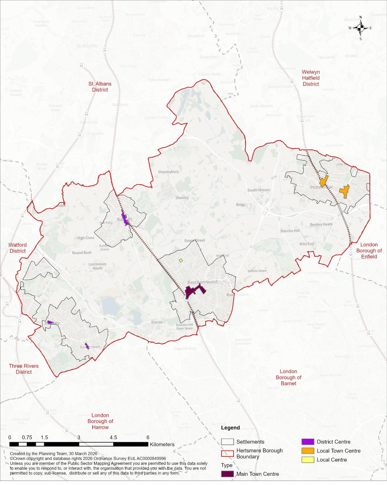
identify Hertsmere’s key retail centres on the Policies Map;
Hertsmere Borough Council
Hertsmere Local Plan Draft Regulation 18 Consultation Document
support town centres by actively resisting out-of-centre retail proposals, including rural diversification, by applying the sequential test approach;
ensure that new town or district centres avoid detrimental impacts on the role and function of existing town and district centres;
seek to maintain a core of local shopping facilities outside of the town and district centres, primarily within local and neighbourhood centres as defined in the Hierarchy above. Any redevelopment that affects a local centre should include re-provision and preferably enhancement of the shopping offer.
Key Retail Centres
Main Town Centre – Borehamwood
Local Town Centres – Darkes Lane, Potters Bar
District Centres – High Street, Potters Bar; Bushey; Bushey Heath; and Radlett
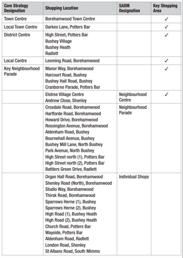
Local Centres, Neighbourhood Centres, Shopping Parades, Corner Shops and other Service Points – to be identified as part of the relevant non-strategic policies.
7.12.3. A possible complimentary approach would be to encourage the comprehensive redevelopment of existing out-of-centre sites that are reaching the end of their lifespan for a mix of uses (inclusive of optimised residential uses). If demonstrably justified. This may include the provision of new main town centres, to serve the new communities being created through urban extensions and/or new settlements.
7.12.4. The policy will also consider the introduction of Article 4 Directions within those centres with designated Core Frontages. This will seek to manage permitted development rights, ensuring that they do not undermine the
Hertsmere Borough Council
Hertsmere Local Plan Draft Regulation 18 Consultation Document
proper planning of an area and secure the economic performance and recovery, local health and wellbeing objectives of the emerging Local plan.
Figure 7.2 Hertsmere’s Centres
Hertsmere Borough Council
Hertsmere Local Plan Draft Regulation 18 Consultation Document
Table 7.3: Hertsmere’s Centres
Hertsmere Borough Council
Hertsmere Local Plan Draft Regulation 18 Consultation Document
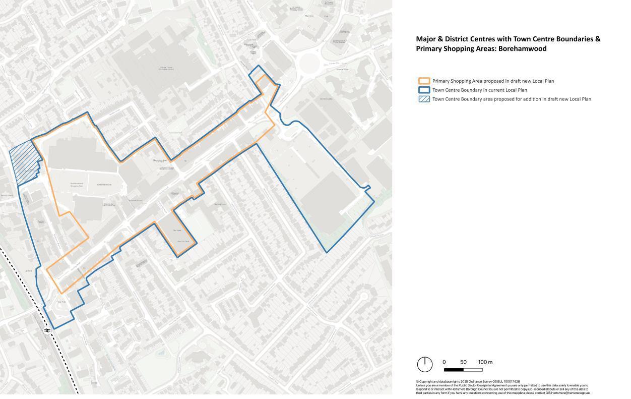
Figure 7.3 Borehamwood Town Centre
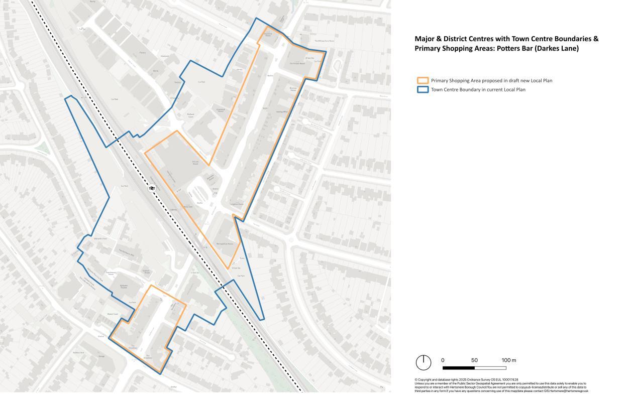
Figure 7.4 Potters Bar Local Town Centre (Darkes Lane)
Hertsmere Borough Council
Hertsmere Local Plan Draft Regulation 18 Consultation Document
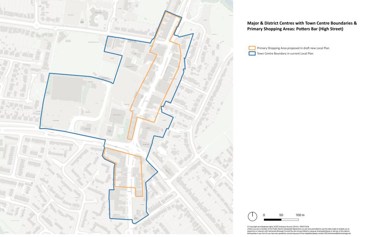
Figure 7.5 High Street, Potters Bar District Centre
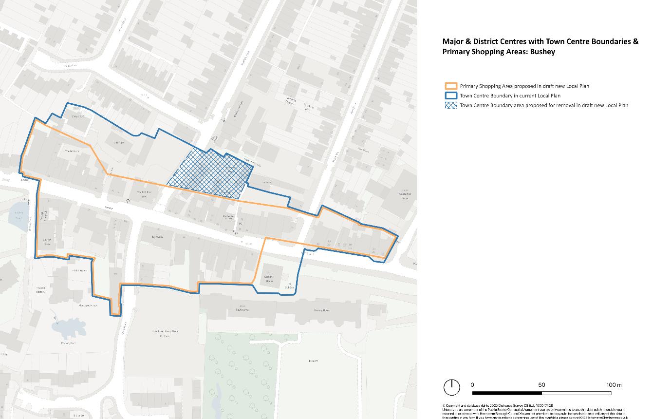
Figure 7.6 Bushey Village District Centre
Hertsmere Borough Council
Hertsmere Local Plan Draft Regulation 18 Consultation Document
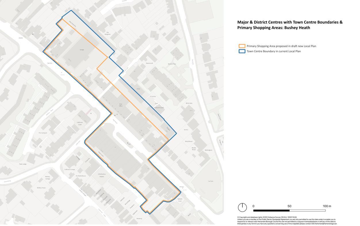
Figure 7.7 Bushey Heath District Centre
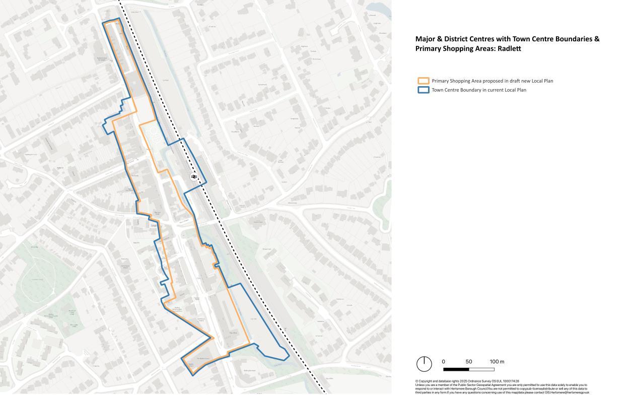
Figure 7.8 Radlett District Centre
Hertsmere Borough Council
Hertsmere Local Plan Draft Regulation 18 Consultation Document
Policy EC13 Optimising the Use of Town Centre Land and Floorspace
7.13.1. This strategic policy seeks to optimise the use of main town centre land and floorspace focusing on Class E, Commercial, Business and Service (a)(g)28
7.13.2. This includes retail, food and drink, financial, professional and other business services, indoor sport and recreation, medical or health services, nurseries, and offices.
7.13.3. The policy will:
Favourably consider mixed use development where it supports the role and function of the centre, is compatible with neighbouring uses, and does not impact negatively on the viability and vitality of the centre; and
Favourably consider residential uses that have separate secured access and do not impact on the retail function of the town centre
7.13.4. The policy will consider where appropriate the need for additional controls over new floorspace to be applied to Class E developments in both town centre and out of centre locations to support the vitality and viability of centres.
Policy EC14 Hertsmere’s Main Town Centre
7.14.1. This non-strategic policy sets out how the Borough’s highest tier of Town Centre serves the Borough and responds to the wider Hertfordshire context, including neighbouring higher-tier centres, specifically St Albans and Watford.
28 The Town and Country Planning (Use Classes) Order 1987
Hertsmere Borough Council
Hertsmere Local Plan Draft Regulation 18 Consultation Document
Main Town Centre – Borehamwood
7.14.2. Hertsmere’s higher tier centre is not seeking to compete with larger neighbouring centres but will continue to have its own role as the Borough grows during the plan period. The Main Town Centre will be identified on the Spatial Strategy Key Diagram and will be shown on the proposals map.
7.14.3. The policy will set out how the Main Town Centre will be stratified. This may include designating primary shopping areas (the retail core) and setting out complementary main town centre uses outside of the core (within the centre). The policy will be linked to Policies EC11 and EC12, and to the settlement and place principles set out under Part 3, and based on the emerging Local Plan’s technical evidence base – Document E5 Retail and Town Centre Uses Study
7.14.4. The policy will also speak to the Sequential and Impact Tests (including possibly setting a Local Floorspace Impact Threshold). These tests are relevant to assessing applications for main town centre development and retail and leisure development larger than 2,500 sqm gross outside of town centres respectively. This is to help ensure the continuing health and viability of town centres. Local authorities can set their own proportionate floorspace threshold for the Impact Test, and the emerging Local Plan’s technical evidence base Document E5 Retail and Town Centre Uses Study recommends setting this threshold at 350 sqm (gross).
7.14.5. Subject to evidence the policy will also speak to how potentially harmful uses (fast food and gambling venues) will be managed and located at peripheral locations. There may also be some merit in the policy considering main town centre (defined under Class E) that generate high levels of vehicle movements – specifically gyms, play spaces and nurseries for young children. These are uses, under Class E, that could legitimately be in the heart of town centres but consequently create a conflict in terms of their accessibility.
Hertsmere Borough Council
Hertsmere Local Plan Draft Regulation 18 Consultation Document
Policy EC15
Hertsmere’s Local Town Centres and District Centres
7.15.1. The non-strategic policy seeks to protect and enhance the vitality and viability of these key local centres by securing long-term main town centre usage The emerging Local Plan’s technical evidence base, Document E5: Retail and Town Centre Uses Study recommends the following hierarchy
Local Town Centres – Darkes Lane, Potters Bar
District Centres – High Street, Potters Bar; Bushey; Bushey Heath; and Radlett
7.15.2. These centres are identified on the Spatial Strategy Key Diagram and will be shown on the proposals map.
7.15.3. The policy will seek to resist the loss to non-main town centre uses at ground floor level; specifically, to uses that could harm the centres vitality and viability. The policy could form the basis of future Article 4 Direction interventions – subject to that being justified by evidence. The policy’s supporting text will set out how existing local centres will continue to support existing residential and employment communities particularly where future intensification (within those areas) is appropriate and being pursued.
Policy EC16
Hertsmere’s Local Centres, Neighbourhood Centres, Shopping Parades, Corner Shops and other Service Points
7.16.1. This non-strategic policy speaks to the next tiers of centres, which will be identified and mapped.
7.16.2. The Borough’s smaller centres are -
Leeming Road, Borehamwood
Manor Way, Borehamwood
Hertsmere Borough Council
Hertsmere Local Plan Draft Regulation 18 Consultation Document
Harcourt Road, Bushey
Bushey Hall Road, Bushey
Cranborne Parade, Potters Bar
High Street, Elstree
Andrew Close, Shenley
Croxdale Road, Borehamwood
Hartford Road, Borehamwood
Howard Drive, Borehamwood
Rossington Avenue, Borehamwood
Aldenham Road, Bushey
Bournehall Avenue, Bushey
Bushey Mill Lane, Bushey
Park Avenue, Bushey
High Street North, Potters Bar
Battlers Green Drive, Radlett
Organ Hall Road, Borehamwood
Shenley Road North, Borehamwood
Thirsk Road, Borehamwood
High Road, Bushey Heath
Hertsmere Borough Council
Hertsmere Local Plan Draft Regulation 18 Consultation Document
High Road, Bushey Heath
Sparrows Herne, Bushey Heath
Sparrows Herne, Bushey Heath
Church Road, Potters Bar
Wayside Parade, Potters Bar
Aldenham Road, Radlett
London Road, Shenley
St Albans Road, South Mimms
7.16.3. These centres will be identified on the Local Plan proposals map.
7.16.4. The policy seeks to protect and enhance the convenience retail offer provided by these places to their surrounding residential and employment communities. A key objective may be to ensure their integrity and resist change of use to residential and thereby prevent their fragmentation. The policy could form the basis of future Article 4 Direction interventions – subject to that being justified by evidence.
Policy EC17 Concentration of Harmful Uses
7.17.1. A non-strategic policy that seeks to manage concentrations of potentially harmful main town centre uses, such as fast-food takeaways, vape shops and betting shops/ gambling venues.
7.17.2. Proposals for such uses will be permitted within designated town centres unless they are within 800m of a secondary school In determining applications, the policy will consider whether a harmful concentration of uses already exists in town centres. Suggested guidelines:
Hertsmere Borough Council
Hertsmere Local Plan Draft Regulation 18
Consultation Document
No more than 10% or two consecutive fast-food units within a centre
No more than 5% or two consecutive betting shops, pay day loan shops or amusement arcades within a centre.
7.17.3. Proposals for fast-food outlets visible from an access point to a secondary school must demonstrate that the proposed use would not undermine any existing or proposed healthy eating policy at that school. This policy will be based on local evidence.
Policy EC18 Culture, Creative Industries and the Evening Economy
7.18.1. A possible strategic policy option that focuses upon cultural uses within the context of the evening economy. Technical evidence is clear that strengthening the evening economy and diversifying hospitality provision will be critical to future-proofing our town centres against evolving consumer trends.
7.18.2. The policy will provide a link to higher-order strategic policies that seek to secure Hertsmere’s town centres as viable and sustainable evening economy destinations that provide a meaningful alternative to St Albans and Watford. This will contribute towards sustainable place-making – by providing choice to residents and businesses so that they do not need to travel or order-out to meet their needs for food and drink. An alternative policy approach is to address this matter through specific settlement and place principles policies IE those for Borehamwood Town Centre.
7.18.3. Additionally, the policy provides a link between the film and television industryand the evening/ cultural economies – this could for example include extending dwell times of TV audiences visiting Borehamwood or encourage uses complimentary to the entertainment venues in Potters Bar and Radlett Within this context, the policy could consider proposals for flexible uses that allow for both daytime and evening activities in a single space.
Hertsmere Borough Council
Hertsmere Local Plan Draft Regulation 18 Consultation Document
Policy EC19 Public Houses
7.19.1. A non-strategic policy option that has been prepared and adopted by other local planning authorities elsewhere. The policy specifically seeks to protect the provision provided by public houses; in terms of use for food and drink, and as hub-uses within wider residential and employment communities. The need for a policy of this type of policy is entirely dependent upon relevant technical evidence – in terms of loss of provision.
Policy
EC20 Markets
7.20.1. This non-strategic policy will seek to protect and enhance markets and market spaces across the Borough. It will encourage new market spaces that complement Hertsmere’s town centre network and hierarchy and contribute to the culture and vibrancy of the Borough. Proposals for town centre redevelopment will be expected to protect and enhance existing market spaces and consider the provision of new spaces. Market proposals outside of main town centres will be subject to the sequential approach to ensure it would not have a detrimental impact on existing town centres
7.20.2. Any proposal affecting an existing market will normally be expected to include re-provision, with consideration of factors including the impact on the vitality and viability of the town centre and its distinctive local character, the provision for small business, and the public realm and townscape. The policy could also speak to management measures, infrastructure and development control.
Policy EC21 Visitor Accommodation/ Hotels
7.21.1. This non-strategic policy will help ensure that any new visitor accommodation will:
Be appropriately located in town centre/edge of centre or otherwise wellconnected locations;
Hertsmere Borough Council
Hertsmere Local Plan Draft Regulation 18 Consultation Document
Be proportionate to their location in terms of size, scale and function;
Not result in a harmful overconcentration in an area;
Not result in a net loss of residential dwelling units;
Comply with the relevant policies in relation to high quality design, parking standards and servicing;
Be sufficiently adaptable to allow for future changes in accommodation standards or changes of use; and
Include ancillary public uses at ground floor level where appropriate (depending on location)
7.21.2. The policy will ensure that any conversion of visitor accommodation into residential use will comply with the relevant policies on residential design quality, amenity space standards and affordable housing.
Chapter 7 Town Centres Questions:
35. Question: Do you agree with the content set out within policies EC11EC21 regarding the Council's proposed approach towards retaining the distinctive character of the Borough's town centres? Yes/No.
36. Question: If you disagree with any of the content, with reference to specific policies, please provide detailed comments or suitable alternatives, and justify your answer with appropriate and proportionate evidence.
Hertsmere Borough Council
Hertsmere Local Plan Draft Regulation 18 Consultation Document
Chapter 8 Social and Community Infrastructure
Policy SCI1 Safeguarding and Securing Social and Community Infrastructure
8.1.1. This strategic policy sets out the Council’s approach towards working with infrastructure partners to deliver improvements and investments in social and community infrastructure29 to ensure that networks continue to meet needs over the plan period The policy will link to the spatial strategy, infrastructure delivery plan, settlement and place principles policies, and site allocations.
8.1.2. Major developments are expected to plan positively to meet local needs for community infrastructure, and all developments should consider this matter. Within site allocations, specifically those creating new communities, the delivery of community facilities should be considered at an early stage using the masterplanning approaches set out under Policy DM3 Other development proposals will be required to demonstrate how any need for community infrastructure generated by the development will be addressed, particularly where this need is identified in the IDP.
8.1.3. The policy will require that infrastructure is either delivered on site, or, where appropriate, a suitable financial contribution will be secured through Section 106 legal agreement. Financial contributions will be used to enhance existing facilities regarding need and viability.
29 This covers a range of facilities that contribute towards sustainable neighbourhoods and a good quality of life, including health services, education and training, community facilities (e.g. pubs, cultural facilities, places of faith), and sport and recreation facilities.
Hertsmere Borough Council
Hertsmere Local Plan Draft Regulation 18 Consultation Document
8.1.4. Development on sites that already house community infrastructure will be supported where provision is retained or replaced on a like for like basis.
8.1.5. Development resulting in the loss of community infrastructure will not be supported unless:
There is clear evidence that there is no current or future need adequate alternative provision meets local need;
The proposal can be justified as part of a public sector disposal of the use to help improved service provision within the local area. This must be evidenced.
In exceptional circumstances a financial contribution may be used to secure funding to enhance other local facilities where it can be shown a use is no longer needed, and it is not viable to re-provide it. This does not apply to the loss of sports and recreation facilities will be assessed against policy SC13.
8.1.6. All proposals affecting community facilities should have regard to the Hertsmere Infrastructure Delivery Plan
Policy SCI2 Delivering High Quality Social and Community Infrastructure
8.2.1. A non-strategic policy that seeks to secure high quality and inclusive social and community infrastructure. The policy directs proposals to appropriate and sustainable locations to ensure they complement and integrate with wider communities. It also seeks to make the best use of land supply (in accordance with wider approaches), and secure provision that will be maintained and managed over its intended lifespan. The policy also addresses proposals that seek to improve existing assets.
8.2.2. The policy will be broadly supportive of proposals relating to the erection of structures and symbols related to or required for religious practices, provided
Hertsmere Borough Council
Hertsmere Local Plan Draft Regulation 18 Consultation Document
they do not have an unacceptable impact on amenity or any impact on highway safety.
Policy SCI3 Delivering Sports, Recreation and Play Spaces
8.3.1. A non-strategic policy that seeks to ensure that new development secures provision that is accessible and inclusive to all. The policy seeks to retain and enhance existing provision.
8.3.2. The policy seeks to ensure that all development proposals that are likely to be occupied or used by children and young people must increase opportunities for play and informal recreation, inclusive of the provision of new informal recreation spaces. This approach may require evidence of spatial deficiencies – and consequentially identify where new provision could provide benefits.
8.3.3. The policy sets out the requirements for play space from new housing developments, based on the available evidence This will be set out under Documents E13a and E13b, which relate to the need for new provision. This technical evidence will be published at the Submission stage of the planmaking process. The policy approach will focus upon securing on-site provision, with off-site contributions in lieu only being considered in exceptional circumstances. The policy will include a formula for calculating off-site contributions.
8.3.4. The policy will also specify how new provision will be of high-quality design that is integrated into the public realm. The policy will also seek to ensure that appropriate management measures are secured for new provision going forward. Proposals that result in the loss of provision will be resisted.
8.3.5. This policy seeks to ensure that development maximises opportunities to provide new or improved sports and recreation provision accessible by people of all ages and abilities to meet the need arising from future growth. It will require that existing sport and recreation facilities should be retained,
Hertsmere Borough Council
Hertsmere Local Plan Draft Regulation 18 Consultation Document
and proposals involving the loss of any provision will only be permitted if supported by the relevant evidence, the Hertsmere Infrastructure Delivery Plan, the Hertsmere Physical Activity and Wellbeing Strategy and any other relevant strategies that may supersede these
8.3.6. It will require that development proposals likely to be occupied by children must increase opportunities for informal recreation. Where the evidence shows a deficiency in play spaces, new housing development must provide improvements in both quantity and quality of play space.
8.3.7. New housing development must incorporate high quality formal play provision. The technical evidence that supports this approach will be set out under document E13b – Outdoor Sports and Playing Pitch Study. The policy will set out criteria for the design of play space around themes including access for all, community cohesion, and integrating natural features.
8.3.8. Off-site provision or a financial contribution will only be acceptable in exceptional circumstances and will be secured by legal agreement. A formula for calculating financial contributions will be included.
8.3.9. Where a new development includes large-scale public realm, this should be designed to encourage independent and active movement and incorporate opportunities for informal play. having regard to the Healthy Streets Approach and relevant good practice guidance, such as Sport England’s Active Design Guidance.
8.3.10. The policy will seek to ensure long-term management of spaces for play.
8.3.11. Any loss of play space through development will be replaced within an appropriate walking distance for the intended age group unless, exceptionally, there is no demonstrable ongoing or future demand.
Hertsmere Borough Council
Hertsmere Local Plan Draft Regulation 18 Consultation Document
Policy SCI4 Nurseries and Childcare Facilities
8.4.1. This is a non-strategic policy that seeks to ensure that childcare provision, including nurseries and child minding, is made in appropriate and sustainable locations to support planned-for housing growth.
8.4.2. The policy will consider proposals based on:
Sustainability and accessibility by public transport, walking and cycling;
Impact on the road network;
Design considerations, such as impact on local character and amenity; and
Ensuring facilities are fit for purpose for all intended users and include outside space where appropriate.
8.4.3. The policy will also consider proposals for new nursery and childcare provision that will be delivered through the conversion of existing residential accommodation. The policy will support such proposals subject to them meeting criteria, which may include:
Consideration of the type of residential unit involved. For example, that a detached unit is more suitable than a semi-detached dwelling, and that terraced housing and/or flats are the least suitable for conversion to this use;
Minimising any harm to the Borough’s available housing stock, and that residential use will be reinstated on cessation of the Class E community use.
Borough Council
Hertsmere Local Plan Draft Regulation 18 Consultation Document
Policy SCI5 Burial Spaces
8.5.1. A non-strategic policy that sets out the Council’s approach towards burial space and how provision will be met over the plan period. The policy will set out the Council’s role in delivering provision and how proposals for new provision will be considered.
8.5.2. This policy will set out the approach to meeting the need for burial space for different communities within Hertsmere over the plan period, based on the available evidence The Council is currently in the process of carrying out a local assessment of burial space provision. Subject to the scale of need, the emerging Local Plan will consider the potential to allocate additional provision. An allocation will be identified through the Local Plan’s PART 3 Hertsmere’s Towns and Places.
8.5.3. A policy might include considerations such as:
Adequately meeting the needs of various faith groups across the Borough;
Being located within reasonable proximity to the community it serves;
Identifying and responding to site constraints, in particular archaeology and flood risk;
Explore the opportunities for protecting and enhancing the openness of the Green Belt; open spaces; and biodiversity, with reference to other policies.
Hertsmere Borough Council
Hertsmere Local Plan Draft Regulation 18 Consultation Document
Chapter 8 Questions:
37. Question: Do you agree with the content set out within policies SCI1-SCI5 regarding the Council's proposed approach towards Social and Community Infrastructure to meet Hertsmere's needs? Yes/No.
38. Question: If you disagree with any of the content, with reference to specific policies, please provide detailed comments or suitable alternatives, and justify your answer with appropriate and proportionate evidence.
Hertsmere Borough Council
Hertsmere Local Plan Draft Regulation 18 Consultation Document
Chapter 9 Green and Blue Infrastructure
Policy GI1 Hertsmere’s Green Infrastructure
9.1.1. A strategic policy that sets out the Council’s borough-wide approach towards green and blue infrastructure. The policy will link back to the Spatial Strategy and the Settlement and Place Principles and will consider a place-based approach to the Borough’s Green Infrastructure and open space network policy. The policy will serve as an overarching mechanism to achieve the Council’s objectives set out it the emerging Hertsmere Green Infrastructure Strategy. The emerging Local Plan will be supported on this matter by Document E10 Green and Blue Infrastructure Study.
9.1.2. The policy seeks to secure a connected, publicly accessible network that makes an important contribution to the Borough’s local distinctiveness including its character and heritage, and towards ensuring that the Borough continues to be open and inclusive of all. The wider Hertfordshire Green Infrastructure Strategy provides a strategic context for the policy, in particular how investment in local networks could connect across the administrative boundary. The policy could stress that the Green Infrastructure network, from a landscape level down to localised elements, is integral to supporting sustainable neighbourhoods and socially cohesive communities.
9.1.3. The policy requires that new development proposals:
Must protect and seek to enhance provision of green infrastructure across the Borough, including by improving or creating new links between its different elements
Must investigate and maximise opportunities to enhance existing green infrastructure and create new provision on site, with reference to the Hertfordshire Green Infrastructure Study;
Hertsmere Borough Council
Hertsmere Local Plan Draft Regulation 18 Consultation Document
Must conserve or improve the character, quality and condition of the prevailing landscape30 across Hertsmere, as evidenced in the Council’s Landscape Sensitivity and Visual Impact Assessment, and the Hertfordshire and national Landscape Character Assessments;
Must make suitable arrangements for the long-term management of green areas and planting, including retention of large trees;
Should explore and where possible deliver opportunities that improve connections between the Borough’s green and open spaces; and
Where appropriate and necessary, proposals will be supported by a health impact assessment that considers inequalities
Policy GI2 Hertsmere’s Waterways and Blue Infrastructure
9.2.1. A possible strategic policy that sets out the role of and approach towards the Borough’s waterways and other blue infrastructure. The policy could require that development proposals identify and respond positively to the unique attributes of waterways, giving particular consideration to their: environmental function and ecological qualities; contribution to the Borough’s network of open spaces; recreational and amenity value; and distinctive features that help to shape and reinforce the Borough’s physical, cultural and historical character.
9.2.2. The policy could require that development proposals on sites containing or adjacent to a main river, ordinary watercourse or other water space must:
30 As described in the Hertfordshire Landscape Character Assessments and Hertsmere Landscape Sensitive and Visual Impact Assessment.
Hertsmere Borough Council
Hertsmere Local Plan Draft Regulation 18 Consultation Document
Ensure that there is no adverse impact on the natural functioning of the watercourse, including by maintaining an undeveloped buffer zone with an adequate set back distance from the watercourse, as agreed with the Council and the Environment Agency.
Investigate and maximise opportunities to enhance or restore river channels, flood flow pathways, floodplains and other natural flood management features with the objective of returning them to their natural state wherever possible.
Incorporate measures to enhance the ecological, amenity, recreational and historic value of water spaces, including enhancing public access to these spaces and removing artificial structures that act as barriers to the movement of animal species
Contribute to a safe waterside environment31 by making appropriate provision for riparian life-saving equipment such as grab chains, access ladders, life buoys, along with information signage and where relevant CCTV.
9.2.3. The policy could also require that development proposals should seek to improve water quality and must ensure that there is no deterioration in the quality of a watercourse or groundwater, in line with the European Water Framework Directive 2000.
Policy GI3 Open Space
9.3.1. A further strategic policy that sets out the Council’s/ local plan’s approach to managing open space provision. This may follow the inter-connected Green
31 For clarity, the term waterside environment is inclusive of those found alongside reservoirs and lakesides.
Hertsmere Borough Council
Hertsmere Local Plan Draft Regulation 18 Consultation Document
Infrastructure/ open space “grid” or network approach set out above. This will set out a hierarchy of open space provision – how it will be managed and new provision secured. This could include designated open spaces –inclusive of strategic open space and local green space; and neighbourhood level open space.
9.3.2. The policy could link to settlement and place principles and their associated site allocations – where this secures new provision. The policy will set out how growth will enhance the quality and function of the Borough’s open spaces.
9.3.3. The policy will map green space across the Borough.
9.3.4. Subject to being supported and demonstrated through the technical evidence, the policy could also map areas of open space deficiency. It is anticipated that evidence included in Document E9 Open Spaces Assessment may support such an approach towards addressing deficiency.
9.3.5. The Policy could consider private open space provision as part of future development and allocated sites, for example provision available on golf courses and as part of institutional uses located in the Green Belt. This part of the policy could in part link back to the spatial strategy – for example, golf courses32 that are no longer viable and are contiguous and well related to the existing urban area may be considered for release to secure the step change in housing delivery. The policy may seek to secure a high percentage of such sites as restored Green Infrastructure and/ or Biodiversity Net Gain banks. In such circumstances, new housing would have to be optimised and well located within these sites (to the existing urban
32 This is an approach that is being tested in the emerging London Plan, which is exploring the potential for surplus and redundant golf courses to contribute towards meeting housing land supply in addition to coming forward as sites upon which biodiversity net gain can be secured.
Hertsmere Borough Council
Hertsmere Local Plan Draft Regulation 18 Consultation Document
area). This approach may be linked to the following policy or alternatively directed to specific sites.
Figure 9.1 Hertsmere’s Open Space Network
Policy GI4 Biodiversity and Access to Nature
9.4.1. A strategic policy that sets out the Council’s approach towards promoting and securing conservation, restoration and management of habitats as well as the protection of species. The policy will work alongside the Local Nature Recovery Strategy (LNRS) as part of a strategic approach to nature conservation and to deliver Biodiversity Net Gain within the Borough.
9.4.2. The policy will continue by setting out the hierarchy of nature conservation sites across the Borough.
9.4.3. The policy will set out the approach towards proposals that could have wider impacts – specifically on designated sites beyond the Borough’s administrative boundary.
9.4.4. The policy will also set out the approach towards Biodiversity Net Gain – the 10% increase in habitat value. It will state that securing on-site Biodiversity Net Gain should be fully integrated into the design-led approach.
9.4.5. The policy will set the requirement that proposals that are likely to impact on designated nature sites will need to submit an Ecological Assessment – the requirement may, if justified, extend to include consultation with the relevant local Biodiversity Partnership.
9.4.6. The policy will set out how planning conditions and/ or legal agreements will be deployed to secure management plans for sites.
9.4.7. The policy could also seek to meet objectives set out in the LNRS33. These include:
Enhancing public green and blue spaces that provide a home for nature
33 These are set out respectively under the Hertfordshire LNRS Actions 2, 5, 7, 8 and 9.
Hertsmere Borough Council
Hertsmere Local Plan Draft Regulation 18 Consultation Document
Enhancing buildings and infrastructure, making new developments more nature-friendly and improving existing buildings and surfaces
Maintaining diverse habitat on brownfield sites
Enhancing urban habitats through utilising nature-based solutions to provide wider environmental benefits; and
Improving access to greenspace for those with the lowest levels of access.
9.4.8. The policy will map out the Borough’s designated nature conservation sites.
9.4.9. The policy will set out the approach to the Watling Chase Community Forest. This may include how it could evolve as a wider strategic, cross-boundary, Green Infrastructure asset.
Hertsmere Borough Council
Hertsmere Local Plan Draft Regulation 18 Consultation Document
9.2 Hertsmere’s Designated Nature Conservation Assets
Figure
Policy GI5 Urban Greening and Trees
9.5.1. A non-strategic policy that seeks to secure a wide range of measures that can be incorporated into buildings and spaces to increase green cover across the Borough, to help meet the objectives of the LNRS. These measures may include tree planting, naturalised biodiverse landscaping, green roofs and walls, hedges, climbers, plants for pollinators, de-paving, rain gardens and sustainable drainage systems using natural or semi-natural features. Urban greening can provide multifunctional benefits for climate change resilience, public amenity including air quality, nature conservation, local character, and health and wellbeing, particularly in more deprived areas.
9.5.2. The policy could seek to achieve a target for Urban Greening Factor – this would require technical evidence that demonstrates that this is necessary and that it would not adversely impact the financial viability of new development.
9.5.3. The policy could speak directly to the incorporation of urban greening measures, such as green roofs and walls, as part of the wider design-led approach – specifically that such measures be considered and integrated from early in the process and not be simple afterthoughts/ add-ons.
9.5.4. Depending upon evidence, the policy could take a robust approach towards trees – both in their retention and incorporation into new development but also in terms of replacement. The policy could clearly set out the requirement to retain all protected and designated trees – IE TPOs, veteran trees and ancient woodland.
9.5.5. The policy would set out the circumstances when a landscape study would be required as part of a proposal submission. This may be linked to the spatial strategy, the settlement and place principles, and the site allocations which could provide additional guidance.
Hertsmere Borough Council
Hertsmere Local Plan Draft Regulation 18 Consultation Document
Policy GI6 Food Growing and Development on Agricultural Land
9.6.1. A possible non-strategic policy that could support the provision and delivery of allotments and other initiatives, such as community gardens (IE fruit trees or vegetable beds on public land) that contribute towards food supply resilience, growing and sustainability. For clarity, the policy could provide a link back to the spatial strategy in respect of quality environments and climate change mitigation – the latter in respect of securing Green Infrastructure and Biodiversity Net Gain, in addition to food supply resilience. The policy will also have links to larger site allocations, which will deliver provision through dedicated food growing allotments and potentially as an integrated component of public realm, planting and landscaping.
9.6.2. The policy would set out that development should be avoided on the best and most versatile agricultural land
Policy GI7 Geodiversity
9.7.1. A non-strategic policy that relates to the protection, promotion and understanding of the Borough’s geodiversity assets - such as Regionally Important Geological Sites (RIGS). The policy will include a map that identifies the location of these sites. There are currently two RIGS identified in Hertsmere. These are the Puddingstone, Radlett and the Shenley Chalk Mine.
Chapter 9 Questions:
39. Question: Do you agree with the content set out within policies GI1-GI7 regarding the Council's proposed approach towards Green and Blue Infrastructure across Hertsmere? Yes/No.
40. Question: If you disagree with any of the content, with reference to specific policies, please provide detailed comments or suitable alternatives, and justify your answer with appropriate and proportionate evidence.
Hertsmere Local Plan Draft Regulation 18 Consultation Document
Chapter 10 Sustainable Design & Infrastructure
Policy SD1 Responding to the Climate Emergency
10.1.1. A strategic policy that sets the emerging Local Plan’s approach in response to the climate emergency. The policy will set out how growth across the Borough will move towards net zero as required by the Environment Act and the Council’s Climate Change and Sustainability Strategy.
10.1.2. The policy provides an overview of the approaches set out in detail in the Chapter’s subsequent non-strategic policies that relate to securing improved air quality, delivering energy infrastructure, dealing with waste and contamination, managing water and flood risk, and moving towards net zero.
10.1.3. The policy’s requirements will be tested and justified in respect of their possible impact on development viability and delivery.
Policy SD2 Sustainable Design and Retrofitting
10.2.1. A strategic policy that seeks to ensure that all development proposals reach high standards of sustainable design. The policy will require that proportionate Sustainable Design Statements be submitted in support of all proposals. For major applications these will need to address landscape design and urban greening; nature conservation; energy use and heat risk management; carbon emissions, including embodied carbon and unregulated emissions; air quality; flood risk and water management; ground conditions; waste reduction and the circular economy; and operational energy and on-site renewable generation. Proposals for minor development will be required to submit an appropriate and proportionately small-scale Sustainable Design Statement
10.2.2. The policy will assume and expect that development proposals consider the re-use of existing buildings before demolition. Proposals that include
Hertsmere Borough Council
Hertsmere Local Plan Draft Regulation 18 Consultation Document
demolition of buildings will be expected to demonstrate why re-use and retrofitting was not possible.
10.2.3. The policy will also speak to external sustainable design standards that the Council expects development to meet. This standard is likely to either be BREEAM (Building Research Establishment Environmental Assessment Method) or LETI (Low Energy Transformation Initiative). These standards are nationally established and are regularly applied to new developments across England. Other standards could be considered subject to them demonstrably sound. They will be applied to all new development over 500sqm gross, as well as major residential and non-residential refurbishment of buildings.
Policy SD3 Managing Heat Risk
10.3.1. A strategic policy that seeks to minimise the adverse impacts of heat risk through the design of buildings and spaces, and through material choices and urban greening measures. This is a key component of successful and sustainable place-making. The policy will work alongside other complementary policies in the emerging Local Plan – including those that seek to secure high quality design, public realm and tree planting and urban greening. The policy will require that all new development must be designed to reduce the potential for internal overheating and reliance on air conditioning systems.
10.3.2. Major developments that incorporate public realm improvements will be required to demonstrate that they have been positively designed to create a comfortable environment. This might be through the provision of shade and other passive cooling measures, with urban greening measures being particularly encouraged, in line with other sections of the Plan.
10.3.3. This policy will be viability tested through the whole plan viability assessment. This technical evidence will be presented published under
Hertsmere Borough Council
Hertsmere Local Plan Draft Regulation 18 Consultation Document
Document K4a Whole Plan Viability Assessment. The policy is linked to other complementary approaches that seek to secure high quality design and gains for nature and the environment, including those on open space provision, Biodiversity Net Gain and urban greening.
Policy SD4 Minimising Green House Gas Emissions
10.4.1. This is a strategic policy that contributes and supports meeting net zero objectives associated with growth. It requires that development proposals must be designed to reduce greenhouse gas emissions in operation and minimise energy demand; both annual and peak. The policy will require that proposals meet the minimum on-site reduction of carbon emissions of at least 35% beyond the baseline of Part L of the Building Regulations 2021 and calculate and minimise emissions from any part of the development that are not covered by Building Regulations: for example, unregulated emissions. For clarity, these requirements will be inclusive of the Future Homes and Buildings Standards34 Development proposals will be required to evidence these in the Sustainable Design Statement, as required by Policy SD2.
10.4.2. The policy will provide a framework for off-site contributions and payments in lieu. These will be sought in exceptional circumstances only - where is not demonstrably possible for proposals to meet net zero requirements onsite Off-site contributions and payments in lieu will be used to contribute towards the delivery of off-site measures that contribute towards meeting net zero objectives. The inclusion of this part of the policy is dependent upon technical evidence that demonstrates that its requirement will not harm the
34 These were introduced on 24 March 2026. The Future Homes and Buildings Standards: Building Circular 01/2026 - letter - GOV.UK
Hertsmere Borough Council
Hertsmere Local Plan Draft Regulation 18 Consultation Document
viability of development proposals. That technical evidence will be published under Document K4a Whole Plan Viability Assessment.
10.4.3. The policy could also seek to encourage major development proposals to assess embodied carbon emissions and maximise opportunities to reduce these emissions. It could require that developers prepare and submit the details of their approach for meeting the net zero-carbon target as a component of an Energy Strategy, which will form part of their submitted Sustainable Design Statement.
10.4.4. Finally, the policy could require that proposals demonstrate how they minimise energy demand of the building(s) in-use. This may be particularly relevant to certain forms of industrial employment use that have a high demand for energy, such as film studios and data centres.
Policy SD5 Improving Air Quality
10.5.1. This is a possible strategic policy that seeks to address air quality matters raised through place-making, as part of the wider climate change agenda. The policy requires that all new development must apply the design-led approach and integrate on-site measures to improve air quality and prevent or minimise the population’s exposure to poor air quality, having regard to the World Health Organisation’s Air Quality Guidelines. This approach integrates with other polices to secure quality growth/ place-making. As a component of securing high quality designed new places, the policy must be considered from the outset of the development process.
10.5.2. The policy requires proposals to seek to improve air quality and be at least air quality neutral. That means that proposals not result in a further deterioration of existing poor air quality; not create any new areas that exceed air quality limits, or delay the date at which compliance will be achieved in areas that are currently in exceedance of legal limits; and not create unacceptable risk of high levels of exposure to poor air quality. For
Hertsmere Borough Council
Hertsmere Local Plan Draft Regulation 18 Consultation Document
clarity, the policy will seek to secure air quality across the whole development process, inclusive of construction into final delivery and occupation.
10.5.3. The policy will set out the requirements for major and minor developments, and community infrastructure proposals. These will be proportionate, reasonable and not onerous.
10.5.4. Development proposals will be considered having regard to their individual and cumulative impacts on air quality, and any documents submitted alongside proposals should ensure due consideration of such issues Proposals that do not meet the requirements set out above will be refused unless it can be suitably demonstrated that adverse impacts can be mitigated to an acceptable level. Mitigation should be provided onsite.
Policy SD6 Energy Infrastructure35
10.6.1. A strategic policy that requires that development proposals be designed in response to a site-specific assessment of the most effective and efficient energy supply options. The policy will encourage proposals for new development to integrate renewable energy sources as part of the designled approach to delivering successful and sustainable places.
10.6.2. The policy will require that development proposals should prioritise connection to decentralised heat networks. Major development proposals must provide a Feasibility Assessment for connecting to, and if possible, extending or interconnecting, existing or planned future heat networks located on or in proximity to the site. This may apply to housing, town centre and industrial employment growth. The policy will encourage all proposals for new data centres and anaerobic digesters to be heat network ready in
35 Energy Infrastructure requirements that relate to specific sites and places will be found under the emerging Local Plan’s Part 3.
Hertsmere Borough Council
Hertsmere Local Plan Draft Regulation 18 Consultation Document
anticipation of connection This is considered a reasonable requirement. The site allocations may provide further guidance on this matter. The policy could require that minor new-build development, conversions and building alterations must demonstrate that they have investigated and maximised opportunities to connect to existing heat networks.
10.6.3. Where a decentralised heat network is planned or likely to be delivered in the future, development proposals should be designed to enable a costeffective connection to it, having regard to energy masterplans where these are relevant.
10.6.4. Dependent on technical evidence, the policy could speak to proposals that use Combined Heat and Power (CHP) and NOx gas boilers. This could state that development proposals for CHP and ultra-low NOx gas boiler communal or district heating systems will only be acceptable where it is demonstrated that other options in the heating hierarchy have been fully investigated and are not feasible, and there will be no adverse impact on air quality. Air Quality Assessments must include full dispersion modelling to assess impacts on nearby receptors. Equally, the policy could also consider where CHP and ultra-low NOx gas boiler systems are acceptable in line with above, proposals should be designed in a way that enables, and does not preclude, the decarbonisation of the site wide communal network in the future.
10.6.5. Major housing development proposals must, and all minor housing proposals should, submit an estimated heat unit supply price (£/kWh), annual standing charges and projected annual maintenance costs for their proposed Energy Strategy.
10.6.6. Technical evidence that supports the policy approach will be published under Document E11 Local Area Energy Plan (LAEP).
Hertsmere Borough Council
Hertsmere Local Plan Draft Regulation 18 Consultation Document
Policy SD7 Minimising and Managing Flood Risk
10.7.1. A strategic policy that sets out how proposals will minimise flood risk –specifically in applying the sequential test and the requirements for sitespecific Flood Risk Assessment (FRA). The policy will include mapping that identifies Flood zones, including fluvial, reservoir groundwater and surface water flood risk. The policy will refer to relevant technical evidence. This will be published under Document E7 Strategic Flood Risk Assessment.
Hertsmere Borough Council
Hertsmere Local Plan Draft Regulation 18 Consultation Document
Figure 10.1 Hertsmere’s Flood Zones
Borough Council Hertsmere Local Plan Draft Regulation 18 Consultation Document
Policy SD8 Water Supply and Wastewater
10.8.1. A strategic policy that sets out how development proposals for new water supply and wastewater facilities or the expansion of existing facilities will be supported subject to meeting criteria.
10.8.2. The policy could require that development proposals should have regard to Drainage and Wastewater Management Plans (DWMPs) and must demonstrate that the local water supply and public sewerage networks have adequate capacity both on and off-site to serve demand arising from the development; or where such capacity does not exist and there are no programmed works, arrangements are made to ensure adequate provision prior to occupation.
10.8.3. Development proposals should ensure the separation of surface and foul water systems, including by rectifying misconnections. Proposals should prioritise mains foul drainage and avoid the use of non-mains drainage for foul water disposal, particularly in Source Protection Zones (SPZ)
10.8.4. Development proposals should be designed to be water efficient, reduce water consumption and minimise pressure on the combined sewer network by integrating SuDS. Planning conditions will be applied to ensure that water efficiency standards are met as development proposals are delivered The policy will consider a water efficiency standard that may go beyond the Building Regulations, for example 110 litres per person per day. This approach is proposed in the context of recent advice from Natural England in relation to water neutrality.
10.8.5. Development proposals within a SPZ will only be supported where there is no risk of contamination to groundwater sources. SPZs will be shown on the Policies Map. The policy will require that development proposals on or in proximity to sites with contaminated land must not introduce new pathways for contamination materials to reach groundwater.
Hertsmere Borough Council
Hertsmere Local Plan Draft Regulation 18 Consultation Document
10.8.6. The above requirements are consistent with Thames Water requirements.
10.8.7. Technical evidence in support of the policy will be provided under Document E8 Water Cycle Study.
Policy SD9 Ground Conditions
10.9.1. A strategic policy for the consideration of proposals on sites that may be contaminated. This policy links in with the wider approach of optimising/ intensifying development on previously developed urban land and securing sustainable and successful place-making. The policy sets out the requirements for development proposals to demonstrate that any risks associated with land contamination, including to human health, public safety and the environment, will be adequately addressed to make the development safe.
10.9.2. The policy will require that development proposals on land that is suspected of being contaminated or potentially contaminated, or if a sensitive use is proposed, must submit a Preliminary Risk Assessment (Phase 1 Study) to identify the level and risk of contamination on the site and adjacent land, and where necessary meet requirements/ submit relevant supporting evidence.
10.9.3. Proposals involving the storage or use of hazardous substances, or development of a site in the vicinity of a hazardous installation, will only be permitted where it is demonstrated that appropriate safeguards are in place to ensure there is no unacceptable risk to human health, public safety and the environment
Policy SD10 Reducing and Sustainably Managing Waste
10.10.1. The emerging Local Plan will include a strategic policy that sets out how waste management will be considered within the context of a circular economy. A circular economy approach will be promoted, with the objective of conserving and making more efficient use of resources. The policy sets
Hertsmere Borough Council
Hertsmere Local Plan Draft Regulation 18 Consultation Document
out how proposals for new waste management and transfer facilities will be considered
10.10.2. Development proposals will be required to apply the waste hierarchy and follow circular economy principles, in line with Policy SD 11.
Policy SD11 Securing a Circular Economy
10.11.1. A new strategic policy that sets out how the circular economy approach will be applied to new development across the Borough. The policy requires that major development proposals should aim to be net zero-waste. This aligns with other related policies. The policy sets out how proposals for new development will manage both the type and volume of recyclable materials and waste arising from the development during the construction and operational phases.
10.11.2. The policy will be tested to ensure that its requirements do not adversely impact on development viability The technical evidence that will be published under Document K4a Whole Plan Viability Assessment.
Policy SD12 Groundwater Source Protection Zones
10.12.1. This non-strategic policy will ensure that development proposals within Source Protection Zones (SPZ) are assessed in relation to their impact on groundwater, in accordance with the Environment Agency guidance. The SPZs will be identified and mapped in the emerging Local Plan.
10.12.2. An assessment of potential impacts and mitigation measures will be required with proposals for some uses that could adversely impact on groundwater. This may include uses such as data centres, waste processing and recycling uses, cemeteries, foul sewage discharge facilities, and storage of hazardous substances – for example, petrol stations and farm waste handling facilities
10.12.3. Technical evidence in support of the policy will be provided under Document E8 Water Cycle Study.
Hertsmere Borough Council
Hertsmere Local Plan Draft Regulation 18 Consultation Document
Policy SD13 Minerals Consultation Area
10.13.1. Hertfordshire County Council are responsible for preparing the Minerals and Waste Local Plan. The County Council commenced a review of the Minerals and Waste Local Plan in 2022.
10.13.2. This non-strategic policy will ensure that development within the Mineral Consultation Area shown on the Policies Map will not sterilise or prevent the future extraction of the mineral resource. Where there may be a significant impact on the resource, advice will be sought from Hertfordshire County Council as Mineral Planning Authority. Those proposing developments that could generate impacts will be encouraged to positively engage with them at an appropriate point in the development process.
Chapter 10 Questions:
41. Question: Do you agree with the content set out within policies SD1SD13 regarding the Council's proposed approach towards Sustainable Design and Infrastructure across Hertsmere? Yes/No.
42. Question: If you disagree with any of the content, with reference to specific policies, please provide detailed comments or suitable alternatives, and justify your answer with appropriate and proportionate evidence.
Chapter 11 Transport and Connectivity
11.0 It is proposed that this chapter of the emerging Local Plan will speak to the delivery and improvement of transport infrastructure networks, choice of travel modes and connectivity. To secure successful and sustainable placemaking the emerging Local Plan seeks to ensure that residents, communities and businesses will have access to a range of sustainable choices that will positively influence how they travel and whether they need to use or own a private motor vehicle.
The emerging Local Plan’s spatial strategy seeks to ensure that the Borough’s future places are genuinely walkable and have good accesses to facilities, amenities, shops and places of employment so that people can decide whether they need to own or use a car. Equally, the emerging Local Plan seeks to build–in sufficient flexibility to ensure that future developments in vehicle use, ownership models and technology can successfully evolve alongside the Borough’s places. An outcomeof thismaybe that the Borough becomes car-lite – either in terms of ownership or usage. This approach is in accordance with national policy, and broadly in alignment with market signals.
Policy TR1 Sustainable Transport and Movement
11.1.1. This will be a strategic policy that sets out the Local Plan’s overarching approach towards securing transport networks that support successful and sustainable place-making. It will focus upon locating future growth within places that already have good access to travel networks; making the most efficient use of land supply at those locations. This approach is consistent and in alignment with the spatial strategy and approaches of optimising the delivery of new growth upon the Borough’s four main settlements. It is also consistent with the wider strategy of minimising harmful impact to the Green Belt and securing its extent in the longer-term.
Borough Council
Local Plan Draft Regulation 18 Consultation Document
11.1.2. The policy will seek to highlight how growth will support the longer-term transition to sustainable travel modes; reduced/ changed car ownership and usage models; and the integration of AI technologies. The policy and its supporting text will also speak to a vision for a car-lite future, where private vehicles are used intelligently.
11.1.3. The policy will require that development proposals should seek to improve and must not adversely impact on the effective functioning and safe use of the Borough’s transport network and public realm, including walking and cycling transport infrastructure.
11.1.4. It will require that development proposals provide protection for and respond positively to the need to facilitate the delivery of the Borough’s network of transport infrastructure as set out in the Council’s Infrastructure Delivery Plan. This will link to site allocations and their associated masterplans.
11.1.5. The policy will also link to the spatial strategy, which will identify possible infrastructure network improvements; for example, to the strategic highway network and/ or improving connections with neighbouring higher order settlements.
11.1.6. If appropriate and necessary, the policy could list strategic transport network improvements required to support our planned-for growth.
11.1.7. The policy requires that development proposals should use the design-led approach to maximise opportunities to remove barriers to access and introduce measures that encourage and enable movement by walking and cycling. The Council considers that the application of the design-led approach is a sound mechanism for ensuring the delivery of successful and sustainable places.
11.1.8. The policy requires that Transport Assessments, Transport Statements and/or Travel Plans must be submitted with applications for Major development and other development proposals that are likely to impact on
Hertsmere Borough Council
Hertsmere Local Plan Draft Regulation 18 Consultation Document
the capacity and functioning of the transport network. Proposals that that do not comply with the above or otherwise prohibit or prevent the necessary and safe functioning of the Borough’s transport infrastructure and network, will be refused unless it can be demonstrated that adverse impacts will be avoided or appropriately mitigated.
11.1.9. The policy will require that development proposals are assessed having regard to the cumulative impact of development including within the Borough and neighbouring local authority areas.
11.1.10. The policy could also speak to smart and intelligent management of growth delivery within the context that it is appropriately phased to avoid excessive strain on the transport network and to ensure additional infrastructure demands arising from the development (including for community and green infrastructure) can be appropriately accommodated. This is likely to be particularly relevant and necessary in relation to the planned-for strategic urban extensions and the potential new settlement. This part of the policy will work alongside wider delivery management measures that seek to secure the intelligent phased delivery of consents.
Policy TR2 Transport Requirements for New Developments (Healthy Streets Approach)
11.2.1. A new strategic policy that adopts and promotes the Healthy Streets approach for new development across the Borough. The policy aligns with wider approaches that secure successful and sustainable place-making; the design-led approach towards delivery; master planning of growth; secure high-quality development; and optimising capacity/ supply.
11.2.2. The policy will set the requirement that all major development proposals must submit a Healthy Streets Assessment as part of the proposals Transport Assessment. These assessments will be proportionate to the development. Proposals will be supported where they have engaged
Hertsmere Borough Council
Hertsmere Local Plan Draft Regulation 18 Consultation Document
positively with the Healthy Streets Approach to deliver public realm and other improvements that support walking, cycling and the use of public transport.
11.2.3. The application of the Healthy Streets Approach will have particular importance within town centres, along and around Growth Corridors and other key movement corridors that link the Borough’s settlements, town centres and places with each other and those outside of the Borough.
11.2.4. The policy will require that development proposals must safeguard and contribute to maintaining and enhancing the Borough’s network of walking routes and cycleways. The merging Local Plan will map and identify these networks.
11.2.5. The policy will seek to secure high quality public realm as a key component of successful and sustainable place-making, which is considered integral to the delivery of the Healthy Streets Approach. This aligns with the emerging Local Plan’s design-led approach that seeks to secure high quality placemaking. The policy will require that development proposals must be designed to ensure that the public realm is not adversely impacted by installations, including advertising columns, and seek opportunities to remove redundant installations wherever possible. This will be particularly important to deliver town centre regeneration.
Policy TR3 Parking
11.3.1. A new non-strategic policy is proposed that introduces a carefully managed approach to parking, and particularly car parking. The new approach will work with other policies to support the delivery of inclusive, healthy, safe, liveable and sustainable neighbourhoods.
11.3.2. The policy will commit the Council to prepare new Borough maximum car parking standards for new developments. It will set out the requirement that development proposals must not exceed these maximum standards. Proposals that optimise the potential for future car-lite development and
Hertsmere Borough Council
Hertsmere Local Plan Draft Regulation 18 Consultation Document
demonstrably provide the flexibility and enable technological advancements in travel will be supported.
11.3.3. Development proposals will be required to make adequate provision for residential and non-residential disabled persons parking. The policy also seeks to address cycle parking provision
11.3.4. The policy could be expanded to include a requirement that development proposals for residential and commercial uses make proportionate provision for rapid charging points. The wording of the policy could be further adjusted to ensure that it has an appropriate level of flexibility to accommodate other technological advancements that may impact upon how parking provision is delivered.
11.3.5. The policy and the wider Local Plan’s approach towards the delivery of car parking provision will be informed and supported by technical evidence that will be published under Document E16 Car Park Study.
Policy TR4 Deliveries, Services and Construction
11.4.1. A new non-strategic policy that requires that development proposals should facilitate sustainable freight, where possible, rail, and road, including for ‘lastmile distribution’. The policy will require that proposals also facilitate and enable safe, clean and efficient delivery and servicing for all the development’s intended occupiers and uses, including emergency services.
11.4.2. Development proposals for commercial and industrial uses should ensure that parking provision for servicing and delivery is commensurate with the specific operational needs of the development.
11.4.3. The policy will set the requirement that major developments and other development proposals that are likely to generate a significant number of vehicle movements from deliveries, servicing or construction submit a Delivery and Servicing Plan and/or Construction Logistics Plan as part of
Hertsmere Borough Council
Hertsmere Local Plan Draft Regulation 18 Consultation Document
their associated Transport Assessment. The content of the Logistics Plan will be proportionate to the proposal.
11.4.4. Those major developments and other developments which are delivered comprehensively through a masterplan, will be required to prepare and implement a site-wide strategy for deliveries, servicing and construction. The expectation is that the site-wide strategy should support the design-led approach and help to enable coordination and integration of servicing requirements across the site(s).
Policy TR5 Taxis and Private Hire Vehicles
11.5.1. A new non-strategic policy that addresses and manages development proposals for offices, ranks, and other operational space associated with taxis and private hire vehicle businesses (including minicabs). The policy will be supportive of proposals that demonstrably meet the policy’s criteria. These criteria will consider the appropriateness of the proposal’s location; possible issues of overcrowding of provision; impacts on wider amenity; potential impacts on walking and cycling routes/ networks; securing highquality design from the development; and ensuring that new provision is safe, welcoming and accessible during operational hours.
Policy TR6 Digital Connectivity
11.6.1. Digital connectivity infrastructure is playing an increasingly important role in the functioning of places and society. It is transforming how infrastructure and services are provided, with innovative ‘Smart City’ technologies that make use of information to deliver more resource and cost-efficient provision. In response, a new strategic policy is being proposed that sets out the Council’s approach towards securing and managing digital connectivity.
11.6.2. The new strategic policy will require that development proposals must demonstrate how they will improve digital connectivity on sites located in
Hertsmere Borough Council
Hertsmere Local Plan Draft Regulation 18 Consultation Document
areas where full-fibre broadband, or equivalent infrastructure, is not currently available or on sites that are otherwise poorly served by broadband coverage, including in designated employment areas and town centres. Development proposals for digital connectivity infrastructure and associated equipment will be supported where they demonstrably meet a series of criteria. These will include justification that the new digital infrastructure is the minimum required to meet operational requirements; opportunities to share infrastructure has been demonstrably explored; consideration of the possible impact on visual amenity; no adverse impacts on open space provision; if located on a highway or footway that residual pedestrian access be provided; and the infrastructure is sensitively located and appropriately designed, and does not detract from local area character. The policy will also require that infrastructure and equipment should be removed as soon as reasonablypracticable once it is not required for use, and older equipment should be upgraded wherever feasible.
Policy TR7 Elstree Aerodrome
11.7.1. Elstree Aerodrome is an established aviation facility that contributes to the local economythrough aviation services, training, maintenance activities and associated employment uses.
11.7.2. A new strategic policy will support the continued operation of the aerodrome and its role as a specialist aviation and business hub within the Borough. The policy will support proposals that maintain the continued use and operational efficiency of the aerodrome, including aviation-related maintenance, training and associated facilities, - where they remain compatible with surrounding land uses and do not give rise to unacceptable impacts on residential amenity, transport networks or the surrounding environment.
11.7.3. Development proposals within or in the vicinity of the aerodrome will be required to ensure that they do not compromise the safe and effective
Hertsmere Borough Council
Hertsmere Local Plan Draft Regulation 18 Consultation Document
operation of the airfield. The Aerodrome Licensee will be consulted on all relevant development within a 3 km buffer zone around the Aerodrome, which will be identified on the Policies Map.
11.7.4. Proposals for aviation-related development will be expected to demonstrate that they are operationally necessary and appropriately designed, and that they do not lead to inappropriate expansion of development into the surrounding countryside.
Policy TR8 Heathrow Airport Safeguarding Zone
11.8.1. This non-strategic policy will set out how the Heathrow Airport Operator will be engaged in relation to proposals for new wind turbines located within the safeguarding zone, which will be shown on the Policies Map.
Hertsmere Borough Council
Hertsmere Local Plan Draft Regulation 18 Consultation Document
Figure 11.1 Elstree Aerodrome and Heathrow Airport Safeguarding Zones
Hertsmere Borough Council
Hertsmere Local Plan Draft Regulation 18 Consultation Document
Chapter 11 Questions:
43. Question: Do you agree with the content set out within policies TR1-TR8 regarding the Council's proposed approach towards Transport and Connectivity across Hertsmere? Yes/No.
44. Question: If you disagree with any of the content, with reference to specific policies, please provide detailed comments or suitable alternatives, and justify your answer with appropriate and proportionate evidence.
Hertsmere Borough Council
Hertsmere Local Plan Draft Regulation 18 Consultation Document
PART 3 Hertsmere’s Towns and Places
Chapter 12 Introduction - Hertsmere’s Towns and Places
Celebrating Hertsmere
12.1.1. Hertsmere is comprised of a range of settlements, places and communities, each with their own character and identity that contribute to the Borough’s overall distinctiveness. The emerging Local Plan seeks to respond to the distinctive qualities of these settlements, while supporting sustainable growth across the Borough. In delivering the spatial strategy and wider vision for Hertsmere, new development should respect and positively contribute to local character, ensuring that proposals respond appropriately to their context in terms of both function and design
12.1.2. To assist in understanding and recognising Hertsmere’s local distinctiveness, and to establish place-based priorities for guiding investment, growth and new development, this part of the emerging Local Plan is organised around Hertsmere’s settlement areas. The table below identifies the settlement areas.
12.1.3. The settlement areas identified in the emerging Local Plan will contribute to the implementation of the Borough’s overall spatial strategy. They provide a framework for directing growth in a way that responds to local circumstances and needs, including the delivery of affordable housing, employment opportunities and necessarysupporting infrastructure. To guide this process, the Plan establishes a long-term vision and a set of place-specific policies for each area. Together, these provide a clear basis for shaping investment priorities and for assessing how development proposals should respond to the opportunities of each part of the Borough.
12.1.4. Further guidance will be prepared that will work alongside the Local Plan, to support the delivery of the vision for each character area. This will include
Hertsmere Borough Council
Hertsmere Local Plan Draft Regulation 18 Consultation Document
the preparation and publication of settlement specific design codes as supplementary planning documents, which will be subject to consultation before being formally adopted. These documents will provide additional detail to help guide future development and investment
12.1.5. The Borough’s settlements, their neighbourhoods and their communities are shaped by a variety of social, economic and geographic relationships. These relationships do not necessarily correspond neatly with the administrative boundary of the borough. It is understood that people’s experience of place is influenced by connections that extend beyond Hertsmere, including nearby towns, adjoining districts, the neighbouring parts of Greater London and the Capital itself. In recognition of this wider context, the vision and place principles for each character area have been developed with an understanding of these cross-boundary relationships and the role Hertsmere plays within the broader sub-regional area.
12.1.6. To set clear expectations in this respect, and to ensure that new development is sensitively integrated into our neighbourhoods, the Local Plan sets out a future vision, key spatial objectives and place principles for each area. These should be used to inform investment decisions and guide development proposals.
12.1.7. In addition, each character area is accompanied by site allocation policies. These establish land use principles and design guidelines for the allocations that will deliver growth over the plan period. These sites have been included within the Local Plan because they are considered necessary to support the delivery of the spatial strategy for the Borough.
Hertsmere Local Plan Draft Regulation 18 Consultation Document
Delivering the spatial strategy and meeting local needs
12.1.8. To facilitate successful and sustainable place-making across the Borough the emerging Local Plan will include site allocation policies36. These will be detailed policies for development sites that are critical to the delivery of the spatial strategy. The delivery of the Local Plan’s site allocations will play an important role in addressing the Borough’s needs for new housing, workspace and main town centre uses, along with supporting infrastructure; including social, transport and green infrastructure.
12.1.9. Each site allocation will include information on the development capacity of a site for different types of land uses. The identified site capacities are indicative and should not be read prescriptively for the purpose of planning applications, where the optimal capacity of a site must be established on a case-by-case basis using the design-led approach, and having regard to relevant planning policies. The table below summarises the minimum scale of delivery outcomes expected by the site allocations, both Borough-wide and by character area. This demonstrates that the Local Plan has identified sites to provide sufficient supply to meet need over the plan-period. It will also demonstrate how the delivery of the site allocations could exceed the Borough’s 15-year housing target as well as exceeding the needs identified in our latest Employment Land and Retail Capacity Studies. This will allow for flexibility and enable the delivery of sufficient homes and non-residential floorspace, should some of the site allocations not be brought forward for development or their delivery delayed.
36 For clarification, the Hertsmere Local Plan Regulation 18 Consultation Document does not contain site allocations but does identify candidate sites. Some of these could be selected and become the site allocations that are included in the Draft Local Plan, to be published under the forthcoming Regulation 19. It highlighted that the site allocations will need to at least meet and deliver the Borough‘s housing needs over the plan period.
Hertsmere Borough Council
Hertsmere Local Plan Draft Regulation 18 Consultation Document
12.1.10. The table below illustrates the site allocations and indicative delivery outcomes over the Plan Period. The table is included in the Consultation Document for illustrative purposes, as in the absence of site allocations37 precise figures cannot currently be identified.
Table 12.1: Settlement Areas and Development for Plan Period
37 For clarity, the Consultation Document identifies and seeks engagement on Candidate Sites, which will be considered for allocation at the next stage of the plan-making process under the Town & Country Planning Regulations 2012 Regulation 19.
Hertsmere Borough Council
Hertsmere Local Plan Draft Regulation 18 Consultation Document
Chapter 13 Hertsmere Borehamwood Area
Context and Character
13.1 Borehamwood is Hertsmere’s largest settlement and functions as the borough’s principal town and economic centre. Together with the adjoining settlement of Elstree, it forms a well-established urban area that plays a key role in delivering the borough’s spatial strategy. Borehamwood contains the greatest concentration of homes, employment, services and transport infrastructure within Hertsmere and, as such, represents one of the most sustainable and accessible locations in the borough for accommodating future growth.
13.2 The town is in the south of Hertsmere, immediately adjacent to the boundary with Greater London. This has influenced both its development pattern and economic role. Borehamwood benefits from strong transport connectivity, particularly through Elstree & Borehamwood railway station, which provides direct Thameslink services to central London and other destinations. The town is also well connected by road, with access to the A1 and the nearby M25, and is served by a network of local bus routes linking Borehamwood with neighbouring settlements and surrounding areas. These connections reinforce Borehamwood’s role as a highly accessible location for residents, workers and businesses.
13.3 The urban form of Borehamwood largely reflects its post-war expansion and is characterised by a range of residential neighbourhoods, commercial areas and established employment sites. Housing across the town includes suburban neighbourhoods, post-war estates and more recent higher-density development within and around the town centre. These residential areas are supported by a range of schools, open spaces, community facilities and local centres that contribute to the town’s role as a service hub for the surrounding area. The settlement is also closely associated with the surrounding
Hertsmere Borough Council
Hertsmere Local Plan Draft Regulation 18 Consultation Document
countryside, which provide an important landscape setting and help maintain separation from nearby settlements.
13.4 At the centre of the town is Borehamwood Town Centre, which serves as Hertsmere’s primary retail and service centre. The town centre provides a mix of retail, leisure, cultural and community uses, including the Boulevard Retail and Leisure Park, restaurants, cafés and a range of local services. The presence of the railway station within the town centre area further reinforces its accessibility and importance as a focus for activity and investment. In recent years the centre has experienced change and investment, including new residential development and improvements to public realm, and it will continue to play an important role in supporting the vitality of the town.
13.5 Borehamwood is also a major employment centre within Hertsmere and the wider sub-region. The town is internationally recognised for its association with the film and television industry, centred on Elstree Studios and the BBC Elstree Centre. These facilities form part of a wider cluster of creative and media-related businesses that contribute significantly to the local economy and the identity of the town. Alongside the film and television sector, Borehamwood accommodates a range of other employment uses across office, industrial and service sectors located within established employment areas.
13.6 Borehamwood’s residential neighbourhoods extend across several distinct areas with their own local character, supported by parks, open spaces and community infrastructure. The town also has strong functional relationships with nearby settlements. The adjoining settlement of Elstree forms part of the same urban area, sharing services, employment opportunities and transport connections. For clarity, Elstree Village is a separate settlement that is defined as a Category V settlement; a village. Other nearby villages such as Shenley and Ridge also maintain close social and economic links
Hertsmere Borough Council
Hertsmere Local Plan Draft Regulation 18 Consultation Document
with Borehamwood, with residents often relying on the town for access to services, employment and public transport.
13.7 These relationships extend beyond Hertsmere, with Borehamwood forming part of a wider network of settlements across south Hertfordshire and neighbouring parts of Greater London. The town’s accessibility and economic role mean it will continue to play a central part in delivering the borough’s spatial strategy. Development opportunities are expected to focus primarily on the redevelopment of previously developed land, regeneration sites and appropriate opportunities for infill and intensification within the existing urban area.
13.8 In nearby villages and smaller settlements that are functionally related to Borehamwood, opportunities for development are expected to be more limited in scale, generally taking the form of small-scale windfall infill development or rural exception schemes that respond to local needs. Through this approach, Borehamwood will continue to function as the focus for homes, employment and services within the southern part of the borough, while maintaining the character of surrounding settlements and the landscape setting of the town.
Vision
Emerging Vision for Borehamwood
13.9 Borehamwood is Hertsmere’s largest settlement and functions as the Borough’s principal town, with strong transport connections, a significant employment base and a wide range of services and facilities. Its accessibility and economic role make it one of the most sustainable locations within the borough to accommodate future growth.
13.10 Through the Local Plan, Borehamwood is expected to play a central role in supporting the delivery of Hertsmere’s spatial strategy. The emerging vision for the town will seek to ensure that growth is planned in a way that supports
Hertsmere Local Plan Draft Regulation 18 Consultation Document
vibrant communities, strengthens the local economy and protects the distinctive character and setting of the Borough.
13.11 Further work is being undertaken on this matter through the Settlement Visions programme, alongside wider Local Plan evidence and engagement with local communities and stakeholders. This work will help to shape a more detailed and place-based vision for Borehamwood, reflecting the opportunities and challenges facing the town and the aspirations of those who live and work there. The vision presented through the Local Plan will therefore continue to evolve through consultation and further technical work.
13.12 Evidence demonstrates that Borehamwood is likely to remain a key location for the delivery of new homes within Hertsmere. Future growth may be accommodated through development within the existing urban area, including the redevelopment and intensification of previously developed land, and where appropriate through carefully planned urban extensions on land around the town. Where larger sites come forward, development would be expected to be comprehensively planned and supported by the infrastructure required to create successful neighbourhoods, including schools, healthcare facilities, open spaces and improvements to sustainable transport networks.
13.13 The regeneration and enhancement of Borehamwood Town Centre is an important part of the town’s future. There is potential for the town centre to evolve as a more vibrant and mixed-use destination that serves residents, workers and visitors. Major redevelopment sites may come forward as mixed-use schemes combining residential development with retail, leisure, workspace and community uses, helping to support the vitality of the high street and strengthen the role of the centre.
13.14 Borehamwood’s identity is also closely linked to its role as one of the most significant centres for film and television production both nationally and internationally. The town’s studios and creative industries form an important
Hertsmere Borough Council
Hertsmere Local Plan Draft Regulation 18 Consultation Document
part of its economy and cultural identity. The Local Plan will therefore consider how best to support the continued growth of this sector while ensuring that Borehamwood continues to function as a major employment centre within Hertsmere.
13.15 The preparation of the Settlement Visions and ongoing engagement will continue to refine the vision for Borehamwood to ensure that future growth is carefully planned and delivered in a way that supports well-connected neighbourhoods, a vibrant town centre and a resilient local economy.
Key Spatial Objectives
13.16 The matrix below identifies the key spatial objectives for the Borehamwood Area:
TO ACHIEVE THIS VISION OUR KEY SPATIAL OBJECTIVES (NOT LISTED IN ORDER OF PRIORITY) ARE TO:
1 Ensure that Borehamwood remains the principal focus for the delivery of new homes within Hertsmere, contributing significantly towards meeting the Borough’s housing needs. New residential development in and around Borehamwood will optimise the efficient use of available land, including through the redevelopment of previously developed sites, the intensification of suitable locations, and the delivery of taller buildings in locations capable of accommodating greater density and height.
2 Support the renewal and comprehensive redevelopment of Borehamwood Town Centre as a vibrant and accessible borough-wide destination. This will strengthen the centre’s role as a focus for retail, leisure, cultural and community activity, including the development of a stronger evening and night-time economy. Public realm and environmental quality will be enhanced through the coordinated redevelopment of key sites, including the shopping centre and the Tesco sites, alongside appropriate intensification across the town centre.
3 Protect and strengthen Borehamwood’s role as one of the United Kingdom’s leading centres for film and television production. This will be achieved by supporting the intensification and expansion of existing studio campuses where appropriate, safeguarding key employment areas, and enabling the growth of creative, technical and supporting businesses that form part of the wider screen and creative industries cluster.
4 Secure high-quality and well-designed development across Borehamwood that responds positively to local character while making efficient use of land.
Hertsmere Borough Council
Hertsmere Local Plan Draft Regulation 18 Consultation Document
New development will contribute towards meeting the borough’s housing needs, including the delivery of genuinely affordable homes, and will optimise development capacity in appropriate locations, including using taller buildings where they can be successfully integrated into the townscape.
13.17 The above key spatial objectives will be further informed by the outputs from the Settlement Visions programme; the above are included as examples of what is possible.
Policy HBA1 Borehamwood Principal Location for Growth
13.18 A new strategic policy is proposed to confirm Borehamwood as the principal focus for accommodating growth within Hertsmere over the Plan period.
13.19 The policy will support the delivery of new homes through redevelopment of previously developed land, regeneration opportunities within the town centre and appropriate intensification within the existing urban area. Where necessary to support the Borough’s housing needs, carefully planned development on land at the edge of the settlement may also be considered where this represents a sustainable location and can be delivered alongside supporting infrastructure.
NB The Council is preparing a vision for Borehamwood that will include a key diagram that links to the spatial strategy
Policy HBA2 Borehamwood Town Centre Regeneration
13.20 A new strategic policy is proposed to support the regeneration and renewal of Borehamwood Town Centre as a vibrant mixed-use destination serving residents, workers and visitors.
13.21 The policy will support redevelopment and intensification of key sites, including opportunities for mixed-use development combining residential, retail, leisure, workspace and community use Improvements to public realm
Hertsmere Borough Council
Hertsmere Local Plan Draft Regulation 18 Consultation Document
and streets, particularly around Shenley Road and the railway station, will also be supported to enhance accessibility and the overall quality of the town centre environment.
Policy HBA3 Elstree Way Employment Corridor
13.22 The Elstree Way Corridor is a key regeneration area within Borehamwood, located between the town centre and the Elstree Way Employment Area. The corridor contains several sites capable of supporting new homes, a mixture of main town centre uses, educational, leisure, social infrastructure, employment activity and public realm improvements.
13.23 This strategic policy for the Elstree Way Corridor will ensure that future development is delivered in a coordinated way, strengthens connections with the town centre and employment areas, and contributes to the regeneration of Borehamwood.
Policy HBA4 Sustainable Movement and Connectivity in Borehamwood
13.24 A strategic policy is proposed to improve sustainable movement across Borehamwood. The policy will support proposals that enhance walking and cycling routes, improve access to public transport and strengthen connections between residential neighbourhoods, employment areas and the town centre.
13.25 Development proposals will be expected to contribute towards infrastructure improvements where necessary to mitigate impacts and support sustainable travel. The emerging Local Plan’s key diagram for Borehamwood will identify existing sustainable travel networks and the improvements that will be delivered through regeneration and new growth.
Policy HBA5 Green Infrastructure and Landscape Setting
13.26 A strategic policy is proposed to protect and enhance Borehamwood’s green and blue infrastructure network. The key diagram for Borehamwood will
Hertsmere Borough Council
Hertsmere Local Plan Draft Regulation 18 Consultation Document
identify the town’s green and blue infrastructure networks and how they connect with existing and future open spaces.
13.27 The policy will support proposals that improve the quality, connectivity and accessibility of parks, open spaces and green and blue corridors. Development proposals will also be expected to respect the landscape setting of the town and contribute to green infrastructure where appropriate, and to consider the potential to re-naturalise culverted watercourses where possible.
Chapter 13 Questions:
45. Question: Do you agree with the Council's recommended approach towards the delivery of the spatial strategy within the Borehamwood area? Yes/No.
46. Question: If you disagree with any of the content, with reference to specific sections, please provide detailed comments or suitable alternatives, and justify your answer with appropriate and proportionate evidence.
Chapter 14 Hertsmere Potters Bar Area
Context and Character
14.1 Potters Bar is one of Hertsmere’s main towns and plays an important role within the Borough’s settlement hierarchy as a significant residential community and local service centre. Located in the eastern part of Hertsmere, the town provides a range of homes, services and community facilities and supports a strong sense of local identity. Potters Bar also serves a wider catchment including surrounding villages and nearby communities.
14.2 The town benefits from strong transport connections, particularly through Potters Bar railway station, which provides direct rail services to central London and other destinations on the East Coast Main Line. Potters Bar is also well connected to the strategic road network, lying close to the M25 and A1(M), and is served by a network of bus routes linking the town with nearby settlements and neighbouring boroughs. These support access to employment, education and services and contribute to Potters Bar’s role as a well-connected commuter town.
14.3 Potters Bar has a distinctive character shaped by its suburban form and its strong relationship with the surrounding countryside. Much of the town developed during the twentieth century and is characterised by established residential neighbourhoods, tree-lined streets and areas of open space. The settlement is closely associated with the surrounding countryside, which provide an important landscape setting and reinforce the town’s semi-rural character. The town also retains elements of its historic identity and community heritage, contributing to a strong sense of place.
14.4 Potters Bar contains two main town centre areas. These are focused upon Darkes Lane, close to the railway station, and the High Street. Together these centres provide a range of shops, services, cafés and community
Hertsmere Borough Council
Hertsmere Local Plan Draft Regulation 18 Consultation Document
facilities serving both residents and visitors. The Wyllyotts Theatre and cultural hub provide an important focus for community and cultural activity within the town. Strengthening the vitality and appearance of the town centres, improving public spaces and enhancing connections between them are important priorities for the future of Potters Bar.
14.5 While Potters Bar is primarily residential in character, the town also supports a range of employment uses, including local businesses, professional services and smaller industrial and commercial activities. Ensuring that opportunities for local employment continue to be supported will help maintain a balanced and resilient local economy.
14.6 The town is surrounded by several smaller settlements and rural communities that maintain close social and functional relationships with Potters Bar. These include villages such as South Mimms, Northaw and Cuffley, as well as nearby communities beyond the borough boundary. Residents of these settlements often rely on Potters Bar for access to shops, services, schools and transport connections.
14.7 In accordance with the emerging Local Plan’s spatial strategy, Potters Bar will continue to play an important role in accommodating development within Hertsmere.
14.8 Opportunities for growth will focus primarily on previously developed land, regeneration sites and appropriate opportunities for infill and intensification within the existing urban area. To ensure a rolling five-year housing land across the plan period growth will also be directed to urban extensions located around the town. In nearby villages and smaller settlements that are functionally related to Potters Bar, opportunities for development are likely to be more limited in scale, typically arising through small windfall schemes or developments that respond to local needs.
14.9 Through this approach, Potters Bar will continue to evolve as a wellconnected and attractive town, supporting homes, services and community life while maintaining its distinctive suburban character and its strong relationship with the surrounding countryside.
Emerging Vision
14.10 A vision for the Potters Bar area will be developed through further evidence gathering, community engagement and the ongoing Settlement Visions work currently being undertaken by the Council. This emerging vision will reflect Potters Bar’s role within Hertsmere’s settlement hierarchy as an important and well-connected town, capable of accommodating a proportion of the borough’s future growth in a sustainable way.
14.11 The vision is expected to set out how new development in Potters Bar can deliver high-quality homes that respond to local needs. This will primarily be achieved through the redevelopment and intensification of sites within the existing urban area, alongside carefully planned development opportunities on land around the town where these represent sustainable locations for growth. Development will be planned comprehensively to optimise the use of land, support housing delivery and ensure that the long-term extent and function of the surrounding countryside is clearly defined and protected.
14.12 The vision is also likely to consider how the town’s centres, including the High Street and Darkes Lane areas, can evolve over time through investment in public realm, infrastructure and mixed-use development. Opportunities may include the redevelopment of key sites to provide a mix of homes, employment space, retail, leisure and community uses, helping to strengthen the vitality of the centres and support a more vibrant local economy.
14.13 Improving sustainable transport connections will form an important part of the vision, including better walking and cycling links between
Hertsmere Borough Council
Hertsmere Local Plan Draft Regulation 18 Consultation Document
neighbourhoods, the town centres and Potters Bar railway station. Enhancing these connections will support a shift towards more sustainable patterns of travel and improve the overall accessibility of the town.
14.14 Through these interventions, the vision for Potters Bar will seek to enhance the town’s distinctive character, support a strong local economy and ensure that new development is well integrated with existing neighbourhoods and supported by the infrastructure required to create a thriving and sustainable community.
Key Spatial Objectives
14.15 A matrix that clearly identifies the key spatial objectives for the Potters Bar Area is set out below:
TO ACHIEVE THIS VISION OUR KEY SPATIAL OBJECTIVES (NOT LISTED IN ORDER OF PRIORITY) ARE TO:
1 Support the delivery of new homes in Potters Bar that contribute towards meeting Hertsmere’s housing needs. New development will optimise the use of suitable land within the existing urban area, including opportunities for regeneration, infill and intensification, while ensuring that development respects the character of the town and its surrounding landscape.
2 Strengthen and enhance Potters Bar’s town centres at Darkes Lane and the High Street as vibrant and attractive destinations for residents, businesses and visitors. This will be achieved through the redevelopment of suitable sites, improvements to public realm and the delivery of mixed-use development that supports retail, leisure, employment and community activity.
3 Improve connectivity and movement throughout Potters Bar by enhancing walking, cycling and public transport links between neighbourhoods, the town centres, the railway station and surrounding green spaces. These improvements will help create a more accessible and sustainable town and support a shift towards more sustainable patterns of travel.
4 Protect and enhance the distinctive character and environmental setting of Potters Bar by maintaining its strong relationship with surrounding countryside and open spaces, while supporting a resilient local economy
Hertsmere Borough Council
Hertsmere Local Plan Draft Regulation 18 Consultation Document
and ensuring that development is supported by the infrastructure required to meet the needs of existing and future communities.
14.16 The above key spatial objectives will be informed by the outputs from the Settlement Visions, the above are included as examples of what is possible.
Policy HPBA1 Potters Bar Town Centres
14.17 A Strategic policy that will support the continued vitality and viability of Potters Bar’s town centres through the redevelopment and regeneration of suitable sites, improvements to public realm and the delivery of mixed-use development that strengthens the role of the centres as places for shopping, leisure, employment and community activity.
14.18 Future development will be required to enhance the quality of the built environment, improve the appearance and function of shopfronts and public spaces, and strengthen connections between the High Street, Darkes Lane and Potters Bar railway station.
Policy HPBA2 Movement and Connectivity in Potters Bar
14.19 A strategic policy will support improvements to walking, cycling and public transport connections between residential neighbourhoods, Potters Bar railway station, the High Street and Darkes Lane town centres, and nearby green spaces. Development proposals will be expected to contribute towards improvements to movement and accessibility where appropriate.
14.20 Enhancing connections across the town will help improve accessibility to services and support more sustainable patterns of travel. The emerging Local Plan’s key diagram for Potters Bar will identify existing sustainable travel networks and the improvements that will be delivered through regeneration and new growth.
Hertsmere Borough Council
Hertsmere Local Plan Draft Regulation 18 Consultation Document
Policy HPBA3 Character, Green Infrastructure and Setting
14.21 The Local Plan will seek to ensure that new development respects the town’s character and contributes positively to the quality of the built and natural environment. A new strategic policy will require that development proposals support the protection and enhancement of green and blue infrastructure, improve access to open spaces and strengthen connections between the town and the surrounding countryside.
14.22 This approach will help maintain the distinctive character of Potters Bar while supporting sustainable development. The emerging Local Plan will include mapping that identifies the town’s areas of character and green infrastructure networks. The mapping will illustrate how improvements will be delivered through regeneration and new growth.
Chapter 14 Questions:
47. Question: Do you agree with the Council's recommended approach towards the delivery of the spatial strategy within the Potters Bar area? Yes/No.
48. Question: If you disagree with any of the content, with reference to specific sections, please provide detailed comments or suitable alternatives, and justify your answer with appropriate and proportionate evidence.
Chapter 15 Hertsmere Bushey Area
Context and Character
15.1 Bushey is one of Hertsmere’s principal settlements and plays an important role within the Borough’s settlement hierarchy as a well-established residential community with a strong local identity. Located in the south-west of the borough, close to the boundary with Watford and the London Borough of Harrow, Bushey forms part of a wider urban area while retaining a distinctive character shaped by its historic village core, suburban neighbourhoods and surrounding countryside.
15.2 The town is characterised by several distinct neighbourhoods, including Bushey Village, Bushey Heath and North Bushey, each with its own identity, heritage and pattern of development. These areas together form a network of communities with strong local character and a long-established sense of place. Bushey Village contains a significant concentration of historic buildings and forms an important conservation area, reflecting the town’s historic origins and its well-known association with the arts and crafts movement.
15.3 Bushey benefits from good connectivity with surrounding places and areas. Bushey railway station, located to the west of the settlement, provides direct rail services to London Euston and other destinations along the West Coast Main Line. The town is also served by several bus routes connecting Bushey with Watford, Stanmore and other neighbouring centres. While car travel remains an important means of movement, there are opportunities to enhance walking and cycling routes between neighbourhoods, town centres, public transport hubs and open spaces.
15.4 Bushey contains several local centres which provide shops, services and community facilities for residents. These include the historic Bushey Village centre and the more modern Bushey Heath centre, both of which support a
Hertsmere Borough Council
Hertsmere Local Plan Draft Regulation 18 Consultation Document
range of independent businesses, cafés and local services. Strengthening the vitality and quality of these centres, while respecting their distinct character, represents an important opportunity for the future of the town.
15.5 The settlement is predominantly residential in character, with a mix of suburban neighbourhoods developed throughout the twentieth century. Housing ranges from historic properties within the village to later suburban development and more recent residential schemes. Bushey is also closely associated with several parks, recreation grounds and green spaces that contribute significantly to the town’s character and quality of life.
15.6 Bushey is surrounded by areas of countryside that form an important landscape setting for the town and help maintain separation from neighbouring settlements. The relationship between the built-up area and surrounding open countryside is a defining feature of Bushey’s identity and contributes to its distinctive character.
15.7 Bushey also maintains strong functional relationships with nearby settlements including Watford, Stanmore and other neighbouring communities, with residents often accessing employment, education and services across a wider area. These relationships mean Bushey forms part of a broader network of settlements across south Hertfordshire and northwest London.
15.8 In accordance with the spatial strategy of the Local Plan, Bushey will continue to play an important role in accommodating development within Hertsmere. Opportunities for growth are expected to focus primarily on previously developed land, regeneration sites and appropriate opportunities for infill and intensification within the existing urban area. This approach will allow Bushey to continue evolving as a thriving community while maintaining its distinctive character and relationship with the surrounding countryside.
Emerging Vision
15.9 A vision for the Bushey area is being developed through further evidence gathering, community engagement and the ongoing Settlement Visions work. The emerging technical evidence that has supported the plan-making process in respect of the Borough’s four main settlements is set out under the visions for the four settlements. This will reflect Bushey’s role as one of Hertsmere’s principal residential communities, while recognising the distinctive character of its different neighbourhoods and centres.
15.10 The vision will consider how Bushey can accommodate an appropriate level of growth while protecting the historic character, landscape setting and community identity that define the town. New development is likely to focus primarily on opportunities within the existing urban area, including the redevelopment of previously developed land and appropriate opportunities for infill and intensification.
15.11 The vision will also explore how the town’s local centres, including Bushey Village and Bushey Heath, can be strengthened through improvements to public realm, investment in local infrastructure and the delivery of mixed-use development that supports shops, services and community facilities. Enhancing the quality and vitality of these centres will help ensure they remain attractive and accessible places for residents and visitors.
15.12 Improving connectivity across Bushey will also form an important component of the emerging vision. Opportunities to enhance walking, cycling and public transport connections between neighbourhoods, town centres, open spaces and Bushey railway station will help support more sustainable patterns of movement and improve access to key destinations.
15.13 The vision will also recognise the importance of Bushey’s network of parks, open spaces and surrounding countryside. Strengthening green infrastructure, improving access to open spaces and supporting biodiversity
Hertsmere Borough Council
Hertsmere Local Plan Draft Regulation 18 Consultation Document
will help ensure that Bushey remains a resilient and environmentally sustainable town.
15.14 Through this approach, the emerging vision for Bushey will seek to ensure that the town continues to evolve as a thriving and distinctive place, supporting homes, services and community life while respecting the character and heritage that make Bushey unique.
Key Spatial Objectives
15.15 A matrix that identifies the key spatial objectives for the Bushey Area is included below –
TO ACHIEVE THIS VISION OUR KEY SPATIAL OBJECTIVES (NOT LISTED IN ORDER OF PRIORITY) ARE TO:
1 Support the delivery of new homes in Bushey that contribute towards meeting Hertsmere’s housing needs. Development will optimise the use of suitable sites within the existing urban area, including opportunities for regeneration, brownfield redevelopment and appropriate infill development, while ensuring that proposals respect the town’s character, heritage and surrounding landscape.
2 Strengthen and enhance Bushey’s local centres, including Bushey Village and Bushey Heath, as attractive and vibrant destinations for residents and visitors. This will be achieved through improvements to public realm, the sensitive redevelopment of suitable sites, and the delivery of mixed-use development that supports local shops, services, employment and community activity.
3 Improve connectivity and accessibility across Bushey by enhancing walking, cycling and public transport links between residential neighbourhoods, town centres, Bushey railway station, open spaces and surrounding communities. These improvements will support more sustainable patterns of movement and improve access to key destinations and services.
4 Protect and enhance Bushey’s distinctive character, heritage assets and environmental setting by maintaining its strong relationship with surrounding countryside and open spaces. Development will be expected to contribute positively to the quality of the built and natural environment while ensuring that new growth is supported by appropriate infrastructure and community facilities.
15.16 The above key spatial objectives will be informed by the outputs from the settlement visions. The matrix included above provides an example of what is possible.
Policy HBUSA1 Bushey Local Centres
15.17 The emerging Local Plan will include a new strategic policy that will support the continued vitality and viability of these centres through the sensitive redevelopment of suitable sites, improvements to public realm and the delivery of mixed-use development that supports local businesses, services and community activity.
15.18 Future development will seek to enhance the quality and character of Bushey’s centres, improving public spaces, shopfronts and pedestrian connections while maintaining the distinctive character and heritage of each centre.
Policy HBUSA2 Movement and Connectivity in Bushey
15.19 A new strategic policy that will support improvements to walking, cycling and public transport connections between residential neighbourhoods, Bushey Village, Bushey Heath, Bushey railway station and surrounding open spaces. Development proposals will be expected to contribute towards improvements to movement and accessibility where appropriate.
15.20 Enhancing connectivity will help improve access to services and public transport while supporting more sustainable patterns of travel. The emerging Local Plan’s key diagram for Bushey will identify existing sustainable travel networks and the improvements that will be delivered through regeneration and new growth.
Hertsmere Borough Council
Hertsmere Local Plan Draft Regulation 18 Consultation Document
Chapter 15 Questions:
49. Question: Do you agree with the Council's recommended approach towards the delivery of the spatial strategy within the Bushey area? Yes/No.
50. Question: If you disagree with any of the content, with reference to specific sections, please provide detailed comments or suitable alternatives, and justify your answer with appropriate and proportionate evidence.
Hertsmere Borough Council
Hertsmere Local Plan Draft Regulation 18 Consultation Document
Chapter 16 Hertsmere Radlett Area
Context and Character
16.1 Radlett is one of Hertsmere’s smaller settlements. In planning terms, it is a Category III Settlement, which equates to it being a small town, but its residents value the sense of village community and strong local identity that they derive from living in Radlett
16.2 Radlett is in the south-west of the borough along the historic Watling Street corridor; the settlement has developed around this historic route and the railway line which continues to shape its structure and character. Radlett is surrounded by open countryside and retains a distinct relationship with its rural setting, which contributes significantly to its character and separation from neighbouring settlements.
16.3 Radlett benefits from strong transport connectivity, most notably through the railway station, which provides direct rail services to London and other key destinations along the Thameslink route. The settlement also benefits from road connections via Watling Street and nearby access to the M1 and M25, enabling convenient travel to surrounding towns and the wider region. Despite this connectivity, Radlett experiences traffic pressures associated with through-traffic along the High Street and surrounding routes, which influences movement across the settlement.
16.4 Radlett’s built form is largely characterised by low-density residential neighbourhoods, many of which consist of large detached and semidetached homes set within generous plots and leafy streets. These areas contribute to its distinctive suburban character and sense of openness. The settlement also contains several heritage assets and conservation areas that reflect its historic development and reinforce the character of its centre and surrounding neighbourhoods.
16.5 Radlett’s centre, located along Watling Street, serves as the focus for retail, services and community life. The centre contains a mix of independent shops, cafés, restaurants and community facilities, including cultural venues such as the Radlett Centre and Radlett Library. These facilities contribute to the strong sense of community identity associated with the village and support a range of cultural and social activities. However, parts of the centre present opportunities for enhancement, particularly in relation to public realm, pedestrian movement and strengthening the diversity of local businesses.
16.6 Radlett also benefits from a network of green spaces and surrounding countryside, which form an important component of the village’s environmental setting. Tree-lined streets, parks and nearby natural areas contribute to the quality of the local environment and support recreational opportunities for residents. Opportunities exist to strengthen these green connections and enhance biodiversity and green infrastructure across the settlement.
16.7 Radlett maintains close functional relationships with surrounding settlements, including Shenley, Aldenham, and Borehamwood, with residents frequently accessing employment, services and transport connections in these nearby locations. These relationships reinforce Radlett’s role within the borough’s settlement hierarchy as a smaller but wellconnected community that benefits from proximity to larger centres.
16.8 In accordance with the spatial strategy set out in this Local Plan, Radlett will continue to accommodate more modest and incremental growth compared with the borough’s larger settlements. Opportunities for development are expected to arise primarilythrough the sensitive redevelopment of previously developed land, small infill sites and the efficient use of under-utilised land within the existing urban area. Development proposals will be expected to
Hertsmere Borough Council
Hertsmere Local Plan Draft Regulation 18 Consultation Document
respect the village’s scale, character and heritage while ensuring that appropriate infrastructure is provided to support local communities.
Emerging Vision
16.9 The Local Plan will develop a Vision for the Radlett Area, which will guide how it evolves over the plan period. This vision will reflect Radlett’s role within Hertsmere’s settlement hierarchy as a distinctive and well-connected small town with a strong sense of place.
16.10 The emerging vision is expected to support carefully managed and incremental growth, focused primarily within the existing urban area. Future development will seek to deliver a mix of housing that responds to local needs, including homes suitable for younger people, families and older residents wishing to remain within the community. Growth will be delivered in a way that respects the settlement’s character and scale while making efficient use of available land.
16.11 The vision will also seek to support the enhancement of Radlett’s centre, ensuring that it continues to function as a vibrant and attractive destination for residents and visitors. Improvements to public realm, streetscape and pedestrian connections will help reinforce the centre’s role as a focal point for community life while supporting local businesses and cultural facilities.
16.12 Improving connectivity and sustainable movement will also form an important part of the vision. Opportunities will be explored to enhance walking and cycling routes, improve public transport accessibility and strengthen connections between neighbourhoods, the centre and Radlett railway station.
16.13 Radlett’s strong environmental setting will remain a defining feature. The Local Plan will seek to protect and enhance green spaces, natural corridors and biodiversity, ensuring that the surrounding countryside and landscape setting continue to contribute to the village’s character and quality of life.
Hertsmere Borough Council
Hertsmere Local Plan Draft Regulation 18 Consultation Document
16.14 Through this approach, Radlett will continue to evolve as a well-connected, distinctive and community-focused settlement, accommodating sensitive growth while maintaining the qualities that make it an attractive and valued place to live.
Key Spatial Objectives
16.15 A matrix that clearly identifies the key spatial objectives for the Radlett Area is set out below.
TO ACHIEVE THIS VISION OUR KEY SPATIAL OBJECTIVES (NOT LISTED IN ORDER OF PRIORITY) ARE TO:
1 Support carefully managed and incremental residential growth within Radlett, primarily through the sensitive redevelopment of previously developed land, infill development and the efficient use of underutilised sites within the existing urban area. Development will deliver a mix of homes that meet local needs, including smaller homes for younger residents and accessible homes for older people, while respecting the character and scale of the village.
2 Enhance and strengthen Radlett Village Centre as the focal point for community life, supporting a vibrant mix of shops, services, cultural uses and community facilities. Improvements will focus on enhancing the public realm, supporting independent businesses and strengthening the attractiveness and functionality of the High Street and surrounding areas.
3 Improve movement and connectivity within Radlett, prioritising walking, cycling and public transport. This will include enhancing connections between neighbourhoods, the village centre and Radlett railway station, improving east–west links across the railway line and supporting measures that reduce congestion and encourage more sustainable patterns of travel.
4 Protect and enhance Radlett’s distinctive character, heritage and green setting, ensuring that new development contributes positively to the village’s built and natural environment. This will include strengthening green infrastructure networks, protecting important views and open spaces, and ensuring that development maintains the qualities that define Radlett as a distinctive village within Hertsmere.
Borough Council Hertsmere Local Plan Draft Regulation 18 Consultation Document
16.16 The key spatial objectives will be informed by the outputs from the settlement Visions. The above are included as examples of what is possible.
Policy HRA1 Radlett Village Centre
16.17 A strategic policy that will support the sensitive redevelopment and enhancement of sites within the village centre to strengthen its vitality and viability. Development proposals will be expected to support a diverse mix of uses, including retail, cafés, restaurants, community facilities and other town centre uses that contribute to the role of the High Street as a focal point for village life.
16.18 Opportunities will also be supported to improve the quality of public realm, shopfronts and pedestrian environments, helping to reinforce Radlett’s distinctive village character and support local businesses.
Chapter 16 Questions:
51. Question: Do you agree with the Council's recommended approach towards the delivery of the spatial strategy within the Radlett area? Yes/No.
52. Question: If you disagree with any of the content, with reference to specific sections, please provide detailed comments or suitable alternatives, and justify your answer with appropriate and proportionate evidence.
Chapter 17 Residential Candidate Sites
17.1 The following section of the Consultation Document sets out a schedule of potential candidate sites that could be considered for allocation for housing development through the emerging Local Plan. The Council has sought to be thorough in identifying as comprehensive list of sites as possible. This is important and necessary to ensure that the Secretary of State’s appointed Inspectors have a clear narrative of how site allocations have been selected and how they will meet needs in full. Furthermore, by providing the Regulation 18 consultation a full list of sites, those with an interest in the plan-making process will have an opportunity to comment.
17.2 For clarification, the sites identified in the Consultation Document are not site allocations. The process has sought to consider all sites that positively respond, and conform, to the emerging Local Plan’s spatial strategy. Sites that do not correspond to the spatial strategy are considered inappropriate and unsustainable.
17.3 The sites included for consideration have come forward through a variety of sources. These include sites submitted to the HELAA38 and the Call for Sites exercises, in addition to identification by the Council. The candidate sites have been subject to technical assessment, which are being published in support of the consultation under Regulation 18 That assessment process has considered the planning and site considerations that may apply. Where appropriate, the process has been informed by the Green Belt Assessment and other technical evidence base studies. The process has considered site capacity, development mix and potential yield.
38 The Hertsmere Housing and Economic Land Availability Assessments – these were undertaken during 2018 and 2024. Call for Sites exercises were undertaken during 2021, 2022 and 2024.
17.4 The Council has undertaken a strategic assessment of possible densities that could achieved from the candidate sites For clarification, the scale, intensity and mix of development proposed for each site responds to the requirement that the Local Plan must meet and deliver local housing needs in full during the plan period and secure a rolling five-year housing land supply. Those responding to the consultation must also consider these requirements. Consultation responses that seek to oppose possible sites must consider the implications for the spatial strategy and the consequential impact on delivering housing needs in full and maintaining a five-year housing land supply. Ideally such responses should identify alternative site opportunities that reflect the spatial strategy.
17.5 Collectively the candidate sites could deliver at least 17,182 dwellings – if they were all delivered during the plan period. This total must be considered against the Borough’s housing requirement, which requires the delivery of at least 16,160 new homes over the plan period for the emerging Local Plan to be found sound.
17.6 The Consultation Document is seeking your views and comments on the candidate sites. Your input forms part of the site selection process. Participants are reminded that the consultation does not provide a choice between growth and no-development. The scale of growth that the emerging Local Plan must accommodate is established and cannot be reduced. In the absence of a local plan, the growth will still happen – albeit in an unplanned manner through the planning appeal process. It is highlighted that current proposals are not optimising the opportunities provided by the sites coming forward. Consequently, it is likely that in an absence of a local plan, that would seek to optimally manage growth, more land will be needed to meet Hertsmere’s needs.
17.7 Consequently, consultation responses that fail to recognise this position and simply state an objection to growth across the Borough, or a particular
Hertsmere Borough Council
Hertsmere Local Plan Draft Regulation 18 Consultation Document
candidate site will be unhelpful. Such responses are unlikely to be positively considered by the Inspectors appointed to represent the Secretary of State at the Local Plan’s examination in public. Participants are encouraged to carefully consider how they respond to the candidate sites. Responses should consider how sites can be made to work as allocations; specifically what requirements, measures and interventions could be reasonably applied to secure sustainable development in a timely manner. In circumstances in which a participant believes that an objection (to the candidate site) is the only possible response, an alternative should ideally be identified.
Hertsmere Borough Council
Hertsmere Local Plan Draft Regulation 18 Consultation Document
[Cover page to be inserted]
Borehamwood Area Sites
Figure 17.1: Borehamwood Candidate Sites
Hertsmere Borough Council
Hertsmere Local Plan Draft Regulation 18 Consultation Document
List of candidate sites:
HBA SA1 Borehamwood Town Centre Retail Park, Borehamwood
HBA SA2 The Point, Shenley Road, Borehamwood
HBA SA3 Tesco Foodstore, Elstree Way, Borehamwood
HBA SA4 Elstree Way Clinic, Cheeky Monkeys Nursery and former Library, Elstree Way
HBA SA5 Hertsmere Civic Offices, Elstree Way, Borehamwood
HBA SA6 Hertsmere Civic Offices Car Park, Elstree Way, Borehamwood
HBA SA7 Elstree & Borehamwood Railway Station, Borehamwood
HBA SA8 Travelodge, Studio Way, Borehamwood
HBA SA9 Borehamwood Fire Station, Elstree Way, Borehamwood
HBA SA10 Borehamwood Job Centre, Elstree Way, Borehamwood
HBA SA11 Cluster on Elstree Way (comprised of office building, Shell Garage and Kwik Fit), Borehamwood
HBA SA12 Regent House & Car Park, north of Allum Lane and west of Theobald Street, Borehamwood
HBA SA13 McDonalds, Elstree Way, Borehamwood
HBA SA14 Leeming Road Local Centre, Borehamwood
HBA SA15 Imperial Place, Elstree Way, Borehamwood
HBA SA16 Well End Strategic Urban Extension, Borehamwood
HBA SA17 Land East of Hartfield Avenue and Fronting onto Barnet Lane, Elstree
HBA SA18 Land north of Barnet Lane, Borehamwood
HBA SA19 Land South of Allum Lane, Elstree
HBA SA20 Parkfields/The Hertsmere Golf Course
HBA SA21 Hollywood Court, Borehamwood
HBA SA22 Old Haberdasher's Sports Ground, Croxdale Road, Borehamwood
HBA SA23 Directors Arms, Borehamwood
HBA SA24 Land North of Allum Lane and East of Watling Street, Elstree
Hertsmere Borough Council
Hertsmere Local Plan Draft Regulation 18 Consultation Document
HBA SA25 Lyndhurst Farm, Green Street, Borehamwood
HBA SA26 Organ Hall Farm, Theobald Street, Borehamwood
Hertsmere Borough Council
Hertsmere Local Plan Draft Regulation 18 Consultation Document
HBA SA1 Borehamwood Town Centre Retail Park, Borehamwood
Site Address Borehamwood Town Centre Retail Park, Borehamwood
Site Details Town centre retail park located behind the main shopping street. Shares a boundary with two storey housing to the north and east, commercial and industrial units to the west, and main town centre uses to the south. Including about 20,000 sqm of main town centre uses; mostly retail but including The Grove Surgery and Anytime Fitness gym.
Hertsmere Borough Council
Hertsmere Local Plan Draft Regulation 18 Consultation Document
Planning Designations and Site Considerations
Strategic Urban Site. Comprehensive mixed-use redevelopment comprised of main-town centre uses (at ground and lower levels) and residential above. Public realm and open space.
Culverted watercourse (Main River) runs beneath the existing car park area. Reservoir flooding.
Planning Status No recent relevant planning history.
Timeframe for Delivery
Indicative Development Capacity
Years 1 – 5 Years 6 –10 Years 11 –15 Beyond 15 Years
Net Residential Units
501 dwellings
Gross Non-Residential Floorspace
To be confirmed – anticipated to include an appropriate level of re-provision of main town centre uses.
This central site is in the heart of Borehamwood’s town centre and is currently principally comprised of large retail units that make inefficient use of this sustainable location. In response a comprehensive mixed-use redevelopment is proposed, which will contribute towards wider town centre regeneration and make more efficient use of this sustainable location. This will comprise compatible main town centre, commercial, community and residential uses. The regeneration of the site will all secure new and improved transport infrastructure including road realignment and walking routes and cycleways. Public realm and environmental enhancements, including new public open space and planting The proposal will need consider any opportunity to resurface and naturalise the culverted watercourse (Borehamwood Brook), bearing in mind the constrained nature of the site and the need to prevent any potential flooding further downstream
The proposal will secure a higher quality townscape and built form that will ensure that Borehamwood Town Centre continues to meet the Borough’s main town centre use needs. The delivery of a comprehensive mixed-use development that includes higher intensity residential accommodation aligns with the spatial strategy proposed for the Borough This is a suitable location for tall buildings. The nature of this opportunity
Hertsmere Borough Council
Hertsmere Local Plan Draft Regulation 18 Consultation Document
suggests that it is likely to come forward for comprehensive redevelopment later in the plan period.
Developers will be required to prepare comprehensive proposals that deliver the mix and at least the quantum of development specified in the site allocation policy. As a strategic urban regeneration site, future proposals must be supported by masterplans, and design codes (if multiple phases are required) evidencing inclusive design. Landowners will be required to demonstrate that they are working positively in partnership to deliver development across the site.
Hertsmere Borough Council
Hertsmere Local Plan Draft Regulation 18 Consultation Document
HBA SA2 The Point, Shenley Road, Borehamwood
Site Address The Point, Shenley Road, Borehamwood
Site Details Town centre site consisting of a single-storey building containing leisure uses (cinema, gym and bingo hall), with rooftop public car parking.
Site Characteristics Site Size ha 1.02 ha Setting Central Urban Ownership Public (HBC) Current Use Town centre leisure uses (cinema and gym) and public surface car parking.
Planning Designations and Site Considerations
Strategic Urban Site. Comprehensive mixed-use redevelopment comprised of main-town centre uses (at ground and lower levels) and residential (with vertical intensification).
Hertsmere Borough Council
Hertsmere Local Plan Draft Regulation 18 Consultation Document
Consideration should be given to the re-provision of the existing public (local authority) car parking and leisure uses (cinema and gym), either onsite or elsewhere within Borehamwood Town Centre.
The site is within the setting of a Locally Listed church and adjoins its cemetery.
Planning Status No recent relevant planning history.
Timeframe for Delivery
Indicative
Years 1 – 5 Years 6 –10 Years 11 – 15
Net Residential Units
Gross Non-Residential Floorspace
To be confirmed – the site has potential for compatible and complementary main town centre uses at the ground floor.
A comprehensive mixed-use redevelopment is proposed, which will contribute towards wider town centre regeneration and make more efficient use of this sustainable location. This will comprise compatible main town centre and residential uses, as well as re-provide the existing public parking. The existing leisure/community uses will ideally be relocated elsewhere as part of comprehensive redevelopment on the town centre, for example within the redeveloped Borehamwood Retail Park site (HBA SA1).
Redevelopment of the site will improve the relationship with the public realm and the nearby locally listed All Saints Church and cemetery and include appropriate levels of residential amenity space and parking.
The delivery of a comprehensive mixed-use development that includes higher intensity residential accommodation aligns with the spatial strategy proposed for the Borough. This is a suitable location for tall buildings, but development must consider the neighbouring two storey residential houses on Mildred Avenue.
Hertsmere Borough Council
Hertsmere Local Plan Draft Regulation 18 Consultation Document
Developers will be required to prepare comprehensive proposals that deliver the mix and at least the quantum of development specified in the site allocation policy. A site allocation will require that future proposals must be supported by masterplans evidencing inclusive design and demonstrate that landowners are working positively in partnership to deliver development across the site.
Hertsmere Borough Council
Hertsmere Local Plan Draft Regulation 18 Consultation Document
HBA SA3 Tesco Foodstore, Shenley Road, Borehamwood
Site Address Tesco Foodstore, Elstree Way, Borehamwood
Site Details Town centre site containing a foodstore, surface-level car park and petrol filling station. The site abuts two storey housing, a public open space and commercial film studio site.
Site Characteristics Site Size ha 4.68 ha Setting Central Urban Ownership Private Current Use
Planning Designations and Site Considerations
Supermarket and surfacelevel car parking
Strategic Urban Site; comprehensive mixed-use redevelopment comprised of main-town centre uses (at ground and lower levels) and residential above (with vertical intensification).
Proximity to Yavneh College & Elstree studios as sensitive neighbours. Group Tree Preservation Order to the south-west corner of the site. Flood zone 2 and 3 near the site access. Surface water flood risk on the site.
Hertsmere Borough Council
Hertsmere Local Plan Draft Regulation 18 Consultation Document
Planning Status No recent relevant planning history.
Timeframe for Delivery Years 1 – 5 Years 6 –10 Years 11 – 15
Indicative Development Capacity
Beyond 15 Years
Net Residential Units
468 dwellings
Gross Non-Residential Floorspace
To be confirmed – comprehensive redevelopment could include the relocation and re-provision of the foodstore within the site (fronting Elstree Way).
A comprehensive mixed-use redevelopment is proposed, which will contribute towards wider town centre regeneration and make more efficient use of this sustainable location and ensure that Borehamwood Town Centre continues to meet the Borough’s main town centre use needs. This approach aligns with the spatial strategy proposed for the Borough
Development will comprise compatible main town centre and residential uses, including the potential re-provision of the supermarket and car parking in a format more suited to the town centre location. This is a suitable location for tall buildings that could exceed ten storeys.
The regeneration of the site will secure new and improved transport infrastructure including a public transport hub, potential road realignment, walking routes and cycleways. The site will be permeable to pedestrians and cyclists, and public realm and environmental enhancements will include new public open space, retention of the through-link to Hillside Avenue, Maxwell Park and Yavneh College, and planting that employs suitable local species to link through with Maxwell Park open space and enhance the ecological network within the town centre.
The development must consider sensitive uses on neighbouring sites including; potential overlooking to the commercially sensitive Elstree Studios backlot; the relationship with Maxwell Park public open space, the relationship with natural environments and biodiversity; and retaining the privacy and residential amenity of the existing 2-storey houses on Whitehouse Avenue and Hillside Avenue.
Hertsmere Borough Council
Hertsmere Local Plan Draft Regulation 18 Consultation Document
The introduction of any harmful town centre uses, such as hot food takeaways, betting shops, vape shops or amusement arcades, should be considered in the light of the proximity to the Hillside Avenue entrance to Yavneh College secondary school and sixth-form college.
Developers will be required to prepare comprehensive proposals that deliver the mix and at least the quantum of development specified in the site allocation policy. As a strategic urban regeneration site, future proposals must be supported by masterplans and design codes (if phasing is required) evidencing inclusive design. Proposals will also be required to demonstrate that landowners are working positively in partnership to deliver development across the site (in accordance with Policy DM3 Masterplans and Comprehensive Development).
Hertsmere Borough Council
Hertsmere Local Plan Draft Regulation 18 Consultation Document
HBA SA4 Elstree Way Clinic, Cheeky Monkeys Nursery and former Library, Elstree Way
Site Address Elstree Way Clinic, Cheeky Monkeys Nursery and former Library, Elstree Way
Site Details The site consists of several single-storey buildings, in varying use including a children’s nursery, an NHS clinic and a community shop. Site
Hertsmere Local Plan Draft Regulation 18 Consultation Document
Planning Designations and Site Considerations
Urban Site: Comprehensive mixed-use redevelopment comprised of social/ community infrastructure (at ground level) and residential above (with vertical intensification).
Scope for comprehensive redevelopment of the area comprising sites HBA SA4, HBA SA5 and HBA SA6.
Surface water flood risk and Flood Zones 2 and 3 on the site.
Planning Status No recent relevant planning history.
Gross Non-Residential Floorspace
To be confirmed – the site has potential for compatible and complementarysocial infrastructure uses at the ground floor.
The delivery of a comprehensive mixed-use development that includes higher intensity residential accommodation will secure a higher quality townscape and built form which aligns with the spatial strategy proposed for the Borough. This is a suitable location for tall buildings. Redevelopment would potentially include re-provision of the existing social and community infrastructure (NHS clinic, day nursery and community pantry) at ground/lower levels if necessary, and high-density residential above. The designled approach and masterplanning process will require that future development integrates with the evolving townscape across Elstree Way.
To secure comprehensive regeneration the site should be brought forward in conjunction with the neighbouring sites (HBA SA5 and HBA SA6) to provide a highquality comprehensive redevelopment of the area, in particular the public realm, and to enable high quality re-provision of existing uses where needed.
Hertsmere Borough Council
Hertsmere Local Plan Draft Regulation 18 Consultation Document
Developers will be required to prepare comprehensive proposals that deliver the mix and at least the quantum of development specified in the site allocation policy. As an urban regeneration site, future proposals must be supported by masterplans, and design codes (if multiple phases are required) evidencing inclusive design. Landowners will be required to demonstrate that they are working positively in partnership to deliver development across the site.
Hertsmere Borough Council
Hertsmere Local Plan Draft Regulation 18 Consultation Document
HBA SA5 Hertsmere Civic Offices, Elstree Way, Borehamwood
Site Address Hertsmere Civic Offices, Elstree Way, Borehamwood
Site Details Local authority offices, police station and NHS clinic. The site occupies a key location on the Shenley Road/Elstree Way/Brook Road roundabout and adjoins the Elstree Way Clinic site (HBA SA4).
Site Characteristics
Planning Designations and Site
Considerations
Site Size ha
0.48 ha Setting Central Urban Ownership HBC Current Use Council offices, police station, NHS clinic
Urban Site: Comprehensive mixed-use redevelopment comprised of social/ community infrastructure (at ground level) and residential above (with vertical intensification).
Scope for comprehensive redevelopment of the area comprising sites HBA SA4, HBA SA5 and HBA SA6.
Surface water flood risk and Flood Zones 2 and 3 on the site.
Planning Status No recent relevant planning history.
Hertsmere Borough Council
Hertsmere Local Plan Draft Regulation 18 Consultation Document
Timeframe for Delivery
Indicative Development Capacity
Years 1 – 5 Years 6 –10 Years 11 – 15
Net Residential Units
95 dwellings
Gross Non-Residential Floorspace
Beyond 15 Years
To be confirmed – the site has potential for compatible and complementary main town centre/ social infrastructure uses at the ground floor.
The delivery of a comprehensive mixed-use development that includes higher intensity residential accommodation will secure a high-quality townscape and built form which aligns with the spatial strategy proposed for the Borough. This is a suitable location for tall buildings so vertical intensification will be expected to make efficient use of the site The design-led approach and masterplanning process will require that future development integrates with the evolving townscape across Elstree Way.
The development should enhance the overall townscape, making the most of this key gateway to the town centre. Walking and cycling improvements will be sought to the Elstree Way/Shenley Road/Brook Road roundabout, which is a key link with the town centre and station This site should be brought forward in conjunction with the neighbouring sites (sites HBA SA4 and HBA SA6) to provide a high-quality comprehensive redevelopment of the area, in particular the public realm, and to enable high quality re-provision of existing uses where needed.
Developers will be required to prepare comprehensive proposals that deliver the mix and at least the quantum of development specified in the site allocation policy. As an urban regeneration site, future proposals must be supported by masterplans, and design codes (if multiple phases are required) evidencing inclusive design. Landowners will be required to demonstrate that they are working positively in partnership to deliver development across the site.
Hertsmere Borough Council
Hertsmere Local Plan Draft Regulation 18 Consultation Document
HBA SA6 Hertsmere Civic Offices Car Park, Elstree Way, Borehamwood
Site Address Hertsmere Civic Offices Car Park, Elstree Way, Borehamwood
Site Details The site comprises of a large car park area, with minimal landscaping features. Boundaries are shared with residential properties to the north and west of the site.
Site Characteristics Site Size ha 1.15 ha Setting Central Urban Ownership HBC Current Use Public car park
Planning Designations and Site Considerations
Urban Site; Comprehensive redevelopment comprised of residential, open space and public realm (with vertical intensification).
Scope for comprehensive redevelopment of the area comprising sites HBA SA4, HBA SA5 and HBA SA6.
Small area of Flood Zone 2 on the western edge of the site.
Planning Status No recent relevant planning history.
Timeframe for Delivery Years 1 – 5 Years 6 –10 Years 11 – 15 Beyond 15 Years
Hertsmere Borough Council
Hertsmere Local Plan Draft Regulation 18 Consultation Document
Indicative Development Capacity
Net Residential Units
115 dwellings
Gross Non-Residential Floorspace
To be confirmed – the site has potential for compatible and complementary main town centre/ social infrastructure uses at the ground floor.
A comprehensive redevelopment is proposed, which will contribute towards wider regeneration along Elstree Way and make more efficient use of this sustainable location, and will primarily comprise of residential uses. The regeneration of the site will secure walking and cycling routes, as well as public realm and environmental enhancements.
The proposal will secure high quality townscape and built form that will ensure that this area contributes positively to the Borehamwood town centre, and meeting the area’s needs. The delivery of a higher intensity residential accommodation aligns with the spatial strategy proposed for the Borough. This is a suitable location for tall buildings. The design-led approach and masterplanning process will require that future development integrates with the evolving townscape across Elstree Way.
This site should be brought forward in conjunction with the neighbouring sites (HBA SA4 and HBA SA5) to provide a high-quality comprehensive redevelopment of the area, in particular the public realm, and to enable high quality re-provision of existing uses where needed.
Developers will be required to prepare comprehensive proposals that deliver the mix and at least the quantum of development specified in the site allocation policy. As an urban regeneration site, future proposals must be supported by masterplans, and design codes (if multiple phases are required) evidencing inclusive design. Landowners will be required to demonstrate that they are working positively in partnership to deliver development across the site.
Hertsmere Borough Council
Hertsmere Local Plan Draft Regulation 18 Consultation Document
HBA SA7 Elstree & Borehamwood Railway Station, Borehamwood
Site Address Elstree & Borehamwood Railway Station, Borehamwood
Site Details The site includes a Railway Station, bus stops, and car park.
Site Characteristics Site Size ha 0.43 ha Setting Central Urban Ownership Public (Network Rail, leased to train operator)
Planning Designations and Site Considerations
Current Use
Railway station and forecourt area
Urban Site; Comprehensive mixed-use redevelopment comprised of sustainable travel network infrastructure (at ground level) and residential above (with vertical intensification).
Small area of surface water flood risk and Flood Zone 2 near the site access. Development has the potential to impact the setting of Grade II listed building Manor House.
Planning Status No recent relevant planning history.
Hertsmere Borough Council
Hertsmere Local Plan Draft Regulation 18 Consultation Document
Timeframe for Delivery Years 1 – 5 Years 6 –10 Years 11 – 15
Indicative Development Capacity
Beyond 15 Years
Net Residential Units
43 dwellings
Gross Non-Residential Floorspace
To be confirmed – the site could include a complementary main town centre uses at the ground floor (as part of new public transport hub).
A comprehensive redevelopment is proposed, which will contribute towards wider town centre regeneration and make more efficient use of this sustainable location, and will primarily comprise of residential uses. The regeneration of the site will secure an enhanced station concourse and improved public realm at ground level, alongside travel infrastructure (bus station, taxi rank, cycle parking and passenger drop-off/pickup) and disabled parking.
The proposal will secure high quality townscape and built form that will ensure that this area contributes positively to the Borehamwood townscape in this strategic location. The delivery of a higher intensity residential accommodation aligns with the spatial strategy proposed for the Borough. This is a suitable location for tall buildings.
Developers will be required to prepare comprehensive proposals that deliver the mix and at least the quantum of development specified in the site allocation policy. As an urban regeneration site, future proposals must be supported by masterplans, and design codes (if multiple phases are required) evidencing inclusive design. Landowners will be required to demonstrate that they are working positively in partnership to deliver development across the site.
Hertsmere Borough Council
Hertsmere Local Plan Draft Regulation 18 Consultation Document
HBA SA8 Travelodge, Studio Way, Borehamwood
Site Address Travelodge, Studio Way, Borehamwood
Site Details The site currently comprises of the Travelodge and attached Toby Carvery. The site is in proximity to residential properties.
Site Characteristics
Planning Designations and Site Considerations
& Restaurant
Urban Site; Comprehensive redevelopment comprised of residential, open space and public realm (with vertical intensification).
The site is in proximity to a large Tree Preservation Order. No other constraints identified on the site.
Planning Status No recent relevant planning history.
Hertsmere Borough Council
Hertsmere Local Plan Draft Regulation 18 Consultation Document
Timeframe for Delivery Years 1 – 5 Years 6 –10 Years 11 – 15
Indicative Development Capacity
Beyond 15 Years
Net Residential Units
33 dwellings
Gross Non-Residential Floorspace
To be confirmed – the site could deliver modest convenience retail provision at ground floor level.
A comprehensive redevelopment is proposed, which will contribute towards wider urban regeneration across Borehamwood and make more efficient use of this sustainable location, and will primarily comprise of residential uses. The regeneration of the site will secure walking and cycling routes, as well as public realm and open space provision. The development will preserve and enhance the ecological value of the adjoining Studio Way Woodland, through improvements to ecological networks and Biodiversity Net Gain
Redevelopment needs to address the juncture between the higher-density central urban area on Elstree Way and lower density 2-storey residential development of Studio Way Estate.
The proposal will secure high quality townscape and built form that will ensure that this area contributes positively to Borehamwood’s townscape, and meeting the area’s needs. The delivery of a higher intensity residential accommodation aligns with the spatial strategy proposed for the Borough.
Developers will be required to prepare comprehensive proposals that deliver the mix and at least the quantum of development specified in the site allocation policy. As an urban site, future proposals must be supported by masterplans, and design codes (if multiple phases are required) evidencing inclusive design. Landowners will be required to demonstrate that they are working positively in partnership to deliver development across the site.
Hertsmere Borough Council
Hertsmere Local Plan Draft Regulation 18 Consultation Document
HBA SA9 Borehamwood Fire Station, Elstree Way, Borehamwood
Site Address Borehamwood Fire Station, Elstree Way, Borehamwood
Site Details The site currently comprises of the fire station on Elstree Way, which is a single storey building. It is located immediately adjacent to SA10.
Site Characteristics Site Size ha 0.36ha Setting Central Urban Ownership Public Current Use Fire Station
Planning Designations and Site Considerations
Urban Site; Comprehensive mixed-use redevelopment comprised of social/ community infrastructure (at ground level) and residential above (with vertical intensification).
Where possible this site should be brought forward alongside site HBA SA10.
Relocation of the Fire Station would be required to suit service requirements. Area of Flood Zone 2 near the site access.
Planning Status No recent relevant planning history.
Hertsmere Borough Council
Hertsmere Local Plan Draft Regulation 18 Consultation Document
Timeframe for Delivery Years 1 – 5 Years 6 –10 Years 11 – 15 Beyond 15 Years
Indicative Development Capacity
Net Residential Units
36 dwellings
Gross Non-Residential Floorspace
To be confirmed – the site has potential for compatible and complementary main town centre/ social infrastructure uses at the ground floor.
A comprehensive redevelopment is proposed, which will contribute towards wider regeneration along Elstree Way and make more efficient use of this sustainable location, and will primarily comprise of residential uses. The regeneration of the site will secure walking and cycling routes, as well as public realm and environmental enhancements.
The redevelopment of the candidate site provides an opportunity to secure high-quality townscape and built form that will ensure that this area contributes positively to Borehamwood’s townscape, and meeting the area’s needs. The delivery of a higher intensity residential accommodation aligns with the spatial strategy proposed for the Borough. This is a suitable location for tall buildings. The design-led approach and masterplanning process will require that future development integrates with the evolving townscape across Elstree Way.
Social and community infrastructure should be incorporated within the development if required, at ground floor level in consultation between the Council and local groups, considering the nearby Maxwell Park Community Centre. It may be an option for development on this site to provide enhancements to Maxwell Park Community Centre in place of community provision on-site, depending on how best to meet community needs and to make efficient use of the land. The site should address the public realm along Elstree Way, but also on Maxwell Road, enhancing the public access to Maxwell Park public open space.
Developers will be required to prepare comprehensive proposals that deliver the mix and at least the quantum of development specified in the site allocation policy. As an urban regeneration site, future proposals must be supported by masterplans, and
Hertsmere Borough Council
Hertsmere Local Plan Draft Regulation 18 Consultation Document
design codes (if multiple phases are required) evidencing inclusive design. Landowners will be required to demonstrate that they are working positively in partnership to deliver development across the site.
The redevelopment of the site is dependent upon the existing use being relocated to an appropriate new home. It is understood that blue light services no longer to have a requirement to secure public facing accommodation, and alternatives can include relocation to highly accessible industrial employment sites. The Council will work with blue light service providers to identify appropriate accessible provision.
Hertsmere Borough Council
Hertsmere Local Plan Draft Regulation 18 Consultation Document
HBA SA10 Borehamwood Job Centre, Elstree Way, Borehamwood
Site Address Borehamwood Job Centre, Elstree Way, Borehamwood
Site Details The site currently comprises of the job centre on Elstree Way, which is a single storey building. It is located immediately adjacent to SA9.
Site Characteristics Site Size ha 0.27 ha Setting Central Urban Ownership Public Current Use Job Centre
Planning Designations and Site Considerations
Urban Site; Comprehensive mixed-use redevelopment comprised of social/ community infrastructure (at ground level) and residential above (with vertical intensification).
Where possible this site should be brought forward alongside Site HBA SA9
Area of Flood Zone 2 near the site access.
Planning Status No recent relevant planning history.
Timeframe for Delivery Years 1 – 5 Years 6 –10 Years 11 – 15 Beyond 15 Years
Hertsmere Borough Council
Hertsmere Local Plan Draft Regulation 18 Consultation Document
Gross Non-Residential Floorspace
To be confirmed – the site has potential for compatible and complementary main town centre/ social infrastructure uses at the ground floor.
A comprehensive redevelopment is proposed, which will contribute t towards wider regeneration along Elstree Way and make more efficient use of this sustainable location, and will primarily comprise of residential uses. The regeneration of the site will secure walking and cycling routes, as well as public realm and environmental enhancements.
The redevelopment of the candidate site provides an opportunity to secure high quality townscape and built form that will ensure that this area contributes positively to Borehamwood’s townscape, and meeting the area’s needs. The delivery of a higher intensity residential accommodation aligns with the spatial strategy proposed for the Borough. This is a suitable location for tall buildings. The design-led approach and masterplanning process will require that future development integrates with the evolving townscape across Elstree Way.
Social and community infrastructure should be incorporated within the development if required, at ground floor level in consultation between the Council and local groups, considering the nearby Maxwell Park Community Centre. It may be an option for development on this site to provide enhancements to Maxwell Park Community Centre in place of community provision on-site, depending on how best to meet community needs and to make efficient use of the land. The site should address the public realm along Elstree Way, but also on Maxwell Road, enhancing the public access to Maxwell Park public open space.
Developers will be required to prepare comprehensive proposals that deliver the mix and at least the quantum of development specified in the site allocation policy. As an urban regeneration site, future proposals must be supported by masterplans, and design codes (if multiple phases are required) evidencing inclusive design.
Hertsmere Borough Council
Hertsmere Local Plan Draft Regulation 18 Consultation Document
Landowners will be required to demonstrate that they are working positively in partnership to deliver development across the site.
Hertsmere Borough Council
Hertsmere Local Plan Draft Regulation 18 Consultation Document
HBA SA11 Cluster on Elstree Way (comprised of office building, Shell Garage and Kwik Fit), Borehamwood
Site Address Cluster on Elstree Way (comprised of office building, Shell Garage and Kwik Fit), Borehamwood
Site Details The site comprises of the former police station, the Shell petrol station, and the Kwik Fit garage. These are primarily single storey buildings. The former police station comprises of a taller building in poor condition.
Site Characteristics Site Size ha 0.74 ha Setting Central Urban Ownership Private Current Use Various uses including car repair garage, petrol filling station and offices.
Planning Designations and Site Considerations
Planning Status
Urban Site; Comprehensive mixed-use redevelopment comprised of main town centre / employment uses (at ground level) and residential above (with vertical intensification).
Areas of Flood Zone 2, and surface water flood risk.
20/0057/OUT: Demolition of the former police station and construction of 1 seven storey and 1 eight storey building containing 96 flats, with associated bin and bike storage, car parking. (Outline Application to include access, appearance, layout & scale, with landscaping matters reserved.)
25/1394/FUL: Demolition of existing sales building and erection of a new sales building with associated works. [Shell petrol stations]
Hertsmere Local Plan Draft Regulation 18 Consultation Document
Indicative Development Capacity
Net Residential Units
74 dwellings
Gross Non-Residential Floorspace
To be confirmed – comprehensive redevelopment of the site could include a mix of complementary main town centre and employment uses (as defined under Class E), could be delivered at ground floor level.
A comprehensive redevelopment is proposed, which will contribute towards wider regeneration along Elstree Way and make more efficient use of this sustainable location, and will primarily comprise of residential uses, with employment uses at ground floor. The regeneration of the site will secure walking and cycling routes, as well as public realm and environmental enhancements.
The redevelopment of the candidate site provides an opportunity to secure high-quality townscape and built form that will ensure that this area contributes positively to Borehamwood’s townscape, and meeting the area’s needs. The delivery of a higher intensity residential accommodation aligns with the spatial strategy proposed for the Borough. This is a suitable location for tall buildings. The design-led approach and masterplanning process will require that future development integrates with the evolving townscape across Elstree Way.
Developers will be required to prepare comprehensive proposals that deliver the mix and at least the quantum of development specified in the site allocation policy. As an urban regeneration site, future proposals must be supported by masterplans, and design codes (if multiple phases are required) evidencing inclusive design. Landowners will be required to demonstrate that they are working positively in partnership to deliver development across the site.
The candidate site has a live consent. It forms part of the Borough’s committed fiveyear housing land supply. The principle of it providing a source of supply that delivers growth is established. On that basis it will become a site allocation.
Hertsmere Borough Council
Hertsmere Local Plan Draft Regulation 18 Consultation Document
As a live consent that contributes towards the Borough’sfive-year housing land supply, the Council considers it reasonable to assume that the site will commence and begin to deliver growth and meet needs in a timely manner39. Consents that fail to deliver and consequently require renewal will in the future be assessed against the new Local Plan. Should that arise, the Council may consider measures that secure greater certainty of timely delivery.
39 To make a meaningful contribution to Housing Delivery performance consented housing schemes must deliver within three years of receiving consent.
Hertsmere Borough Council
Hertsmere Local Plan Draft Regulation 18 Consultation Document
HBA SA12 Regent House & Car Park, north of Allum Lane and west of Theobald Street, Borehamwood
Site Address Regent House & Car Park, north of Allum Lane and west of Theobald Street, Borehamwood
Site Details The site comprises of Regent House, a three-storey office building on the corner of Allum Lane and Theobald Street, and the car park to the rear.
Site Characteristics
Planning Designations and Site Considerations
Site Size ha
0.55 ha Setting Urban Ownership
Private (office buildings) and Public (car park)
Current Use
Office buildings, and car park to the rear serving railway station
Urban Site; Comprehensive redevelopment comprised of residential and public realm (with vertical intensification).
Potential development impact on the setting of Grade II listed building Manor House.
Hertsmere Borough Council
Hertsmere Local Plan Draft Regulation 18 Consultation Document
Planning Status No recent relevant planning history.
Timeframe for Delivery Years 1 – 5 Years 6 –10 Years 11 – 15 Beyond 15 Years
Indicative Development Capacity
Net Residential Units
55 dwellings
Gross Non-Residential Floorspace
To be confirmed – comprehensive redevelopment of the site could include a mix of complementary main town centre and employment uses (as defined under Class E), to be delivered at ground floor level.
A comprehensive redevelopment is proposed, which will contribute towards wider town centre regeneration and make more efficient use of this sustainable location, and will primarily comprise of residential uses. The regeneration of the site will secure walking and cycling routes, as well as public realm and environmental enhancements.
The redevelopment of the candidate site provides an opportunity to secure high-quality townscape and built form that will ensure that this area contributes positively to Borehamwood’s townscape at this prominent location, and meeting the area’s needs. The delivery of a higher intensity residential accommodation aligns with the spatial strategy proposed for the Borough. This is a suitable location for tall buildings. The design-led approach and masterplanning process will require that future development integrates with the town centre’s wider townscape.
Developers will be required to prepare comprehensive proposals that deliver the mix and at least the quantum of development specified in the site allocation policy. As an urban regeneration site, future proposals must be supported by masterplans, and design codes (if multiple phases are required) evidencing inclusive design. Landowners will be required to demonstrate that they are working positively in partnership to deliver development across the site.
Hertsmere Borough Council
Hertsmere Local Plan Draft Regulation 18 Consultation Document
HBA SA13 McDonalds, Shenley Road, Borehamwood
Site Address McDonalds, Elstree Way, Borehamwood
Site Details The site contains a fast-food outlet, with associated parking and drive-thru facilities.
Site Characteristics Site Size ha 0.26 ha Setting Central Urban Ownership Private Current Use Fast food restaurant and associated parking/drive-thru
Planning Designations and Site
Considerations
Urban Site; Comprehensive mixed-use redevelopment comprised of main town centre/ employment uses (at ground level) and residential above (with vertical intensification).
The building on site is a locally listed building, and presumption against demolition of locally listed buildings applies. Flood Zone 2 and 3, as well as surface water flood risk near the site access. Potential intensification of remaining site.
Hertsmere Borough Council
Hertsmere Local Plan Draft Regulation 18 Consultation Document
Planning Status No recent relevant planning history.
Timeframe for Delivery Years 1 – 5 Years 6 –10 Years 11 – 15 Beyond 15 Years
Indicative Development
Capacity
Net Residential Units
26 dwellings
There is potential for the re-provision of appropriate new main town centre uses, as defined under Class E, across the ground floor.
A comprehensive redevelopment is proposed, which will contribute towards wider town centre regeneration and make more efficient use of this sustainable location, and will primarily comprise of residential uses. The regeneration of the site will secure walking and cycling routes, as well as public realm and environmental enhancements.
The redevelopment of the candidate site provides an opportunity to secure high-quality townscape and built form that will ensure that this area contributes positively to Borehamwood’s townscape at this prominent location, and meeting the area’s needs. The delivery of a higher intensity residential accommodation aligns with the spatial strategy proposed for the Borough. This is a suitable location for tall buildings. The design-led approach and masterplanning process will require that future development integrates with the town centre’s wider townscape.
Whilst the site includes a locally listed building, the opportunities for urban regeneration and intensification present across other neighbouring sites suggest that it merits consideration through the plan-making process under Regulation 18.
Hertsmere Borough Council
Hertsmere Local Plan Draft Regulation 18 Consultation Document
Developers will be required to prepare comprehensive proposals that deliver the mix and at least the quantum of development specified in the site allocation policy. As an urban regeneration site, future proposals must be supported by masterplans, evidencing inclusive design. Landowners will be required to demonstrate that they are working positively in partnership to deliver development across the site.
Hertsmere Borough Council
Hertsmere Local Plan Draft Regulation 18 Consultation Document
HBA SA14 Leeming Road Local Centre, Borehamwood
Site Address Leeming Road Local Centre, Borehamwood
Site Details The area comprises of ground floor retail units with some flatted accommodation above.
Site Characteristics Site Size ha 1.42 ha Setting Urban Ownership Public – HBC Current Use Mixed use –shopping parade with residential above
Planning Designations and Site
Considerations
Urban Site; Comprehensive mixed-use redevelopment comprised of main town centre/ employment uses (at ground level), public realm and residential above (with vertical intensification).
Re-provision of designated local shopping centre. The site is adjacent to a public right of way. Some surface water flood risk near the site.
Hertsmere Borough Council
Hertsmere Local Plan Draft Regulation 18 Consultation Document
Planning Status No recent relevant planning history.
Timeframe for Delivery Years 1 – 5 Years 6 –10 Years 11 – 15
Indicative Development Capacity
Beyond 15 Years
Net Residential Units
71 dwellings (net)
Gross Non-Residential Floorspace
It is anticipated that the existing main town centre uses will be re-provided on a like-for-like basis across the redeveloped site.
A comprehensive redevelopment is proposed, which will contribute towards wider town centre regeneration and make more efficient use of this sustainable location, and will primarily comprise of residential uses, and provision of retail units at ground floor.
The regeneration of the site will secure walking and cycling routes, as well as public realm and environmental enhancements.
The regeneration of the site could secure high-quality townscape and built form that will ensure that this area contributes positively to Borehamwood’s townscape at this prominent location, and meeting the area’s needs. The delivery of a higher intensity residential accommodation aligns with the spatial strategy proposed for the Borough. The site may be capable of accommodating higher density development in the form of mid-rise buildings. Proposals for tall new buildings will be required to demonstrate that the surrounding townscape has sufficient capacity for them to be accommodated.
Developers will be required to prepare comprehensive proposals that deliver the mix and at least the quantum of development specified in the site allocation policy. The re-provision of the existing main town centre uses provide an opportunity to improve the quality available across the site. This will benefit both existing and future communities.
Hertsmere Borough Council
Hertsmere Local Plan Draft Regulation 18 Consultation Document
As an urban regeneration site, future proposals must be supported by masterplans, and design codes (if multiple phases are required) evidencing inclusive design. Landowners will be required to demonstrate that they are working positively in partnership to deliver development across the site.
Hertsmere Borough Council
Hertsmere Local Plan Draft Regulation 18 Consultation Document
HBA SA15 Imperial Place, Elstree Way, Borehamwood
Site Address Imperial Place, Elstree Way, Borehamwood
Site Details The site comprises of office buildings and associated multi-storey car park.
Site Characteristics Site Size ha 2.3 ha Setting Central Urban Ownership Private Current Use Offices
Planning Designations and Site Considerations
Urban Site; Comprehensive mixed-use redevelopment comprised of main town centre/ employment uses (at ground level), public realm and residential above (with vertical intensification).
Site is adjacent to existing public right of way. Culverted water course on the eastern boundary of the site. Existing multi-storey car park is in Flood Zones 2 and 3, while much of the site is covered by surface water flood risk.
Planning Status No relevant recent planning history.
Timeframe for Delivery Years 1 – 5 Years 6 –10 Years 11 – 15 Beyond 15 Years
Hertsmere Borough Council
Hertsmere Local Plan Draft Regulation 18 Consultation Document
Gross Non-Residential Floorspace
To be confirmed – comprehensive redevelopment of the site could include a mix of complementary main town centre and employment uses (as defined under Class E), to be delivered at ground floor level.
A comprehensive redevelopment is proposed, which will contribute towards wider town centre regeneration and make more efficient use of this sustainable location, and will primarily comprise of residential uses, and provision of retail units and main town centre uses at ground floor. The regeneration of the site will secure walking and cycling routes, as well as public realm and environmental enhancements.
The redevelopment of the candidate site provides an opportunity to secure high-quality townscape and built form that will ensure that this area contributes positively to Borehamwood’s townscape at this prominent location, and meeting the area’s needs. The delivery of a higher intensity residential accommodation aligns with the spatial strategy proposed for the Borough. This is a suitable location for tall buildings. The design-led approach and masterplanning process will require that future development integrates with the evolving townscape across Elstree Way.
Consideration should be given to the sensitivity of the neighbouring Elstree Studios in terms of overlooking. Proposals should seek to improve public realm along Elstree Way, while creating connections and increasing access to Maxwell Park. Should the site become an allocation, its status as a Main Employment Area will be re-assessed. This will require consequential changes to Local Plan Policy EC2
Developers will be required to prepare comprehensive proposals that deliver the mix and at least the quantum of development specified in the site allocation policy. As an urban regeneration site, future proposals must be supported by masterplans, and design codes (if multiple phases are required) evidencing inclusive design. Landowners will be required to demonstrate that they are working positively in partnership to deliver development across the site.
Hertsmere Borough Council
Hertsmere Local Plan Draft Regulation 18 Consultation Document
HBA SA16 Well End Strategic Urban Extension, Borehamwood
Site Address Well End Strategic Urban Extension, Borehamwood
Site Details This allocation relates to three sites: land to the north of Hertswood Academy (east of Cowley Hill and west of Well End Road); land to the north of Rowley Lane and south of Buckettsland Lane; and land to the south of Rowley Lane. The three sites are comprised of undeveloped land
Planning Designations and Site Considerations
Strategic Urban Extension; Comprehensive strategic development, comprised of higher density residential, social/ community infrastructure, open spaces, main town centre and complimentary employment uses.
Development of these sites has the potential to impact the setting of various listed buildings: The Thatched Lodge (Grade II); two listed buildings at Pursley
Hertsmere Local Plan Draft Regulation 18 Consultation Document
Farm (Grade II); Tomten (Grade II); Wheatsheaf Farm House (Grade II); Buckettsland Farm House and Barn (Grade II); two buildings at High Canons Farm House (Grade II); Barnet Lodge (Grade II); Nelson Cottage (Grade II); Barn south west of Rowley Farm House (Grade II).
Sites near Local Wildlife Sites. A public right of way passes through SA17a and SA17b. Limited surface water and flood zone 2 and 3 areas.
Planning Status
HBA SA16a: 17/2494/OUT: Outline planning application for the erection of 58 dwellings to include access, layout and scale. (All other matters reserved)
Live application pending determination.
HBA SA16a: 20/2141/FUL: Demolition of existing buildings and erection of 16 dwellings together with associated parking, amenity space and access from Cowley Hill. (Amended plans and Description - increase in number of units).
(Updated Equestrian Needs Assessment received 28/07/21)
Permission implemented.
Timeframe for Delivery Years 1 – 5 Years 6 –10 Years 11 – 15 Beyond 15 Years
Total: 3,750 dwellings
Gross Non-Residential Floorspace
It is anticipated that the comprehensive development of the site as a new strategic urban extension will incorporate an appropriate mix of main town centre, social infrastructure and employment uses. The scale of non-residential uses will be informed through by the master planning of the site.
A strategic urban extension is proposed, which would make efficient use of land and contribute towards meeting the Borough’s housing needs. The development of this site will secure new and improved transport infrastructure, including walking routes and cycle ways, as well as public realm and environmental enhancements, including new public open space and planting.
The development of the candidate site provides an opportunity to secure high-quality townscape and built form that will ensure that this area contributes positively towards Borehamwood’s needs. Proposals in this location would seek to deliver comprehensive strategic development, comprised of higher density residential,
Hertsmere Borough Council
Hertsmere Local Plan Draft Regulation 18 Consultation Document
social/community infrastructure, open spaces and town centre uses. The delivery of the above aligns with the spatial strategy proposed for the Borough.
Developers will be required to prepare comprehensive proposals that deliver a mix of compatible and complementary uses, and at least the quantum of development specified in the site allocation policy. The delivery of a mix of main town centre, social infrastructure and employment uses as an integrated part of the strategic urban extension will ensure that this new place will be partially self-sustaining. Strong infrastructure network connections with Borehamwood will ensure that this becomes a successful and sustainable place. The delivery of a mix of complementary main town centre uses, as defined under Class E, will create a new centre for residents and communities. It is anticipated that this will include compatible and complementary main town centre uses to serve the new community; as defined under Class E (g) (i) (ii) and (iii).
As a strategic site, future proposals must be supported by masterplans, and design codes (if multiple phases are required) evidencing inclusive design. Landowners will be required to demonstrate that they are working positively in partnership to deliver development across the site.
It is anticipated that this strategic urban extension could secure a sustained housing land supply that contributes towards meeting the Borough’s needs across the plan period. Strategic opportunities such as those provide by this candidate site will be necessary for the emerging Local Plan to be found sound when it is subject to examination.
Hertsmere Borough Council
Hertsmere Local Plan Draft Regulation 18 Consultation Document
HBA SA17 Land East of Hartfield Avenue and Fronting onto Barnet Lane, Elstree
Site Address Land East of Hartfield Avenue and Fronting onto Barnet Lane, Elstree
Site Details The site comprises of undeveloped land to the south of Elstree/Borehamwood and contains part of a newly registered village green.
Site Characteristics Site Size ha 5.77 ha Setting Urban Ownership Private Current Use Open land
Planning Designations and Site Considerations
Urban extension; Development comprised of higher density residential and open space uses
Site is partially above railway tunnels. Local Wildlife Site covering over 50% of the site. A group Tree Preservation Order is partially contained within site. The site contains the registered village green that would be retained and protected as part of this allocation.
Planning Status 23/0053/OUT: Residential development of up to 74 dwellings, with associated landscaping, amenity space, Self-Build plots, sustainable urban drainage
Hertsmere Local Plan Draft Regulation 18 Consultation Document
(SuDs), and associated works. (Outline Application to include Access, with all other matters Reserved).
Appeal allowed. Permission expiring on 25 Mar 2027.
25/1122/REM: Application for the approval of reserved matters relating to layout, scale, appearance and landscaping (including details required conditions 3, 6, 7, 8, 9, 10, and 27), for a residential development of 73 dwellings, with associated landscaping, amenity space, custom and self-build housing plots, sustainable urban drainage (SuDs), and associated works, pursuant to outline planning permission 23/0053/OUT.
Live application pending determination.
Timeframe for Delivery Years 1 – 5 Years 6 –10 Years 11 – 15
Indicative Development Capacity Net Residential Units
74 dwellings based on existing consent
Beyond 15 Years
An urban extension is proposed, which would make efficient use of land and contribute towards meeting the Borough’s housing needs. The development of this site will include walking routes and cycle ways, as well as public realm and environmental enhancements, including new public open space and planting.
The development of the candidate site provides an opportunity to secure high-quality townscape and built form that will ensure that this area contributes positively towards Borehamwood’s needs. Proposals in this location would seek to deliver comprehensive development, comprised of residential development, and open space uses. The delivery of the above aligns with the spatial strategy proposed for the Borough.
Developers will be required to prepare comprehensive proposals that deliver the mix and at least the quantum of development specified in the site allocation policy. As an urban extension site, future proposals must be supported by masterplans, and design codes (if multiple phases are required) evidencing inclusive design. Landowners will be required to demonstrate that they are working positively in partnership to deliver development across the site.
Borough Council
Hertsmere Local Plan Draft Regulation 18 Consultation Document
The candidate site has a live consent. It forms part of the Borough’s committed fiveyear housing land supply. The principle of it providing a source of supply that delivers growth is established. On that basis it will become a site allocation.
As a live consent that contributes towards the Borough’sfive-year housing land supply, the Council considers it reasonable to assume that the site will commence and begin to deliver growth and meet needs in a timely manner40. Consents that fail to deliver and consequently require renewal will in the future be assessed against the new Local Plan. Should that arise, the Council may consider measures that secure greater certainty of timely delivery.
40 To make a meaningful contribution to Housing Delivery performance consented housing schemes must deliver within three years of receiving consent.
Hertsmere Borough Council
Hertsmere Local Plan Draft Regulation 18 Consultation Document
HBA SA18 Land north of Barnet Lane, Borehamwood
Site Address Land north of Barnet Lane, Borehamwood
Site Details The site comprises a combination of semi improved natural grassland, broad leaved woodland, scrub and amenity/ managed grassed areas.
Site Characteristics Site Size ha 12.55 ha Setting Urban Ownership Private Current Use Pastureland and woodland
Planning Designations and Site Considerations
Urban extension; Development comprised of higher density residential and open space uses (inclusive of retained woodland).
Site encompasses Local Wildlife Site and part of the Woodcock Hill Village Green, which should not be included within the developable area of the site. Large areas of group TPOs. Public right of way exists through the site. Small pockets of surface water flood risk.
Planning Status 23/0937/OUT: Outline planning application for the erection of up to 220 dwellings, including 50% affordable housing, self-build/custom-build plots, green infrastructure (including public open space, play area, landscape planting and
Hertsmere Borough Council
Hertsmere Local Plan Draft Regulation 18 Consultation Document
sustainable drainage systems), ecological enhancements to Woodcock Hill Village Green, new multi-modal vehicular access from Furzehill Road, emergency, pedestrian and cycle access from Carrington Avenue, and associated works and development. Appeal allowed. Permission expiring 27 Nov 2027
25/1554/REM: Application for the approval of reserved matters relating to details of appearance, landscaping, layout and scale pursuant to outline planning permission 23/0937/OUT (granted under APP/N1920/W/24/3346928) for the erection of 220 dwellings and associated open space, hard and soft landscaping, car parking and other infrastructure.
Live application pending determination
Timeframe for Delivery Years 1 – 5 Years 6 –10 Years 11 – 15
Indicative Development Capacity
Net Residential Units
220 dwellings [based on consent]
Beyond 15 Years
An urban extension is proposed, which would make efficient use of land and contribute towards meeting the Borough’s housing needs. The development of this site will include walking routes and cycle ways, as well as public realm and environmental enhancements, including new public open space and planting. The existing woodland on the site will be retained.
The redevelopment of the candidate site provides an opportunity to secure high-quality townscape and built form that will ensure that this area contributes positively towards Borehamwood’s needs. Proposals in this location would seek to deliver comprehensive development, comprised of residential development, and open space uses. The delivery of the above aligns with the spatial strategy proposed for the Borough.
Developers will be required to prepare comprehensive proposals that deliver the mix and at least the quantum of development specified in the site allocation policy. As an urban extension site, future proposals must be supported by masterplans, and design codes (if multiple phases are required) evidencing inclusive design. Landowners will be required to demonstrate that they are working positively in partnership to deliver development across the site.
Borough Council
Hertsmere Local Plan Draft Regulation 18 Consultation Document
The candidate site has a live consent. It forms part of the Borough’s committed fiveyear housing land supply. The principle of it providing a source of supply that delivers growth is established. On that basis it will become a site allocation.
As a live consent that contributes towards the Borough’sfive-year housing land supply, the Council considers it reasonable to assume that the site will commence and begin to deliver growth and meet needs in a timely manner41. Consents that fail to deliver and consequently require renewal will in the future be assessed against the new Local Plan. Should that arise, the Council may consider measures that secure greater certainty of timely delivery.
41 To make a meaningful contribution to Housing Delivery performance consented housing schemes must deliver within three years of receiving consent.
Hertsmere Borough Council
Hertsmere Local Plan Draft Regulation 18 Consultation Document
HBA SA19 Land South of Allum Lane, Elstree
Site Address Land South of Allum Lane, Elstree
Site Details Undeveloped land.
Site Characteristics Site Size ha 10.46 ha Setting Urban Ownership Private Current Use Open land
Planning Designations and Site Considerations
Urban extension; Development comprised of higher density residential and open space uses (inclusive of retained trees, and hedgerows).
Public right way across the site. Tree Preservation Orders present near the edges of the site. Proximity to Archaeological Site (ARCH-17). Development has the potential to impact the setting of two Grade II listed buildings at Nicoll Farmhouse. Limited areas of surface water flood risk, and Flood Zone 2 near the eastern edge of the site.
Planning Status 24/0442/FUL: Development of an Integrated Retirement Community (IRC) including the erection of a retirement living complex (comprising apartment, bungalows and an associated facilities building) a doctors surgery, hard and soft
Hertsmere Borough Council
Hertsmere Local Plan Draft Regulation 18 Consultation Document
landscaping, sustainable drainage systems, highways works including a new access off Allum Lane, and all associated works.
Live application pending determination.
Timeframe for Delivery Years 1 – 5 Years 6 –10 Years 11 – 15 Beyond 15 Years
Indicative
Non-residential Floorspace
Re-located and re-provided NHS GP Surgery.
An urban extension is proposed, which would make efficient use of land and contribute towards meeting the Borough’s housing needs. The development of this site will include walking routes and cycle ways, as well as public realm and environmental enhancements, including new public open space and planting. The existing woodland on the site would be expected to be retained.
The redevelopment of the candidate site provides an opportunity to secure high-quality townscape and built form that will ensure that this area contributes positively towards Borehamwood’s needs. Proposals in this location would seek to deliver comprehensive development, comprised of residential development, and open space uses. The development of the candidate site could secure the re-location and reprovision of the NHS GP Shopwick Surgery from Elstree Village. The delivery of the above aligns with the spatial strategy proposed for the Borough.
Developers will be required to prepare comprehensive proposals that deliver the mix and at least the quantum of development specified in the site allocation policy. As an urban extension site, future proposals must be supported by masterplans, and design codes (if multiple phases are required) evidencing inclusive design. Landowners will be required to demonstrate that they are working positively in partnership to deliver development across the site.
Hertsmere Borough Council
Hertsmere Local Plan Draft Regulation 18 Consultation Document
HBA SA20 Parkfields/The Hertsmere Golf Course
Site Address Parkfields/The Hertsmere Golf Course
Site Details Golf course and parkland
Site Characteristics
Planning Designations and Site Considerations
Site Size ha 46.65 ha Setting Edge of urban area Ownership Public – HBC and Private Current Use Public park/open space and golf course
Urban Extension; Comprehensive strategic development, comprised of higher density residential, social/ community infrastructure, open spaces, and main town centre uses.
Public right of wayacross the site. Individual and group Tree Preservation Orders present. Adjacent to Local Wildlife Site. Pockets of surface water flood risk and limited areas of Flood Zone 2. Proximity to The Waggon and Horses Public House (Grade II listed); South Medburn Farm (Grade II listed); Nicoll Farm (two
Hertsmere Local Plan Draft Regulation 18 Consultation Document
Grade II listed); Allum House (Grade II listed) although separation distances might mitigate impacts. Ecology and Open Space considerations.
Planning Status No recent relevant planning history.
Timeframe for Delivery Years 1 – 5 Years 6 –10 Years 11 – 15
Indicative Development Capacity
Beyond 15 Years
Net Residential Units 1073 dwellings
Gross Non-Residential Floorspace
It is anticipated that the comprehensive development of the site as a new strategic urban extension will incorporate an appropriate mix of main town centre, social infrastructure and employment uses. The scale of non-residential uses will be informed through by the master planning of the site.
A strategic urban extension is proposed, which would make efficient use of land and contribute towards meeting the Borough’s housing needs; comprised of higher density residential, social/community infrastructure, open spaces, and main town centre uses. The development of this site will secure new and improved transport infrastructure, including walking routes and cycle ways, as well as public realm and environmental enhancements, including new public open space and planting.
The development of the candidate site provides an opportunity to secure high-quality townscape and built form that will ensure that this area contributes positively towards Borehamwood’s needs. Proposals in this location would seek to deliver comprehensive strategic development, comprised of higher density residential, social/community infrastructure, open spaces and town centre uses. The delivery of the above aligns with the spatial strategy proposed for the Borough.
Developers will be required to prepare comprehensive proposals that deliver the mix and at least the quantum of development specified in the site allocation policy. As a strategic urban extension, future proposals must be supported by masterplans, and design codes (if multiple phases are required) evidencing inclusive design. Landowners will be required to demonstrate that they are working positively in partnership to deliver development across the site.
It is anticipated that this strategic urban extension could secure a sustained housing land supply that contributes towards meeting the Borough’s needs across the plan period. Strategic opportunities such as those provide by this candidate site will be
Hertsmere Borough Council
Hertsmere Local Plan Draft Regulation 18 Consultation Document
necessary for the emerging Local Plan to be found sound when it is subject to examination.
Hertsmere Borough Council
Hertsmere Local Plan Draft Regulation 18 Consultation Document
HBA SA21 Hollywood Court, Borehamwood
Site Address Hollywood Court, Deacons Hill Road, Elstree
Site Details Existing residential apartments on the site.
Site Characteristics Site Size ha 0.71 ha Setting Urban Ownership Private Current Use Residential flats
Planning Designations and Site Considerations
Urban Site; Comprehensive redevelopment comprised of residential uses (with vertical intensification).
Complicated by potential for individual flats to be in separate leasehold ownerships. Proximity to group Tree Preservation Order. Development has the potential to impact the setting of Grade II listed Manor House.
Planning Status No recent relevant planning history.
Timeframe for Delivery Years 1 – 5 Years 6 –10 Years 11 – 15 Beyond 15 Years
A comprehensive redevelopment is proposed, which will make more efficient use of this sustainable location, and will primarily comprise of residential uses. The regeneration of the site will secure walking and cycling routes, as well as public realm and environmental enhancements.
The redevelopment of the candidate site provides an opportunity to secure high-quality townscape and built form that will ensure that this area contributes positively to Borehamwood’s townscape, and meeting the area’s needs. The delivery of a higher intensity residential accommodation aligns with the spatial strategy proposed for the Borough. This is a suitable location for tall buildings. The design-led approach and masterplanning process will require that future development integrates with the town centre’s wider townscape.
Developers will be required to prepare comprehensive proposals that deliver the mix and at least the quantum of development specified in the site allocation policy. As an urban regeneration site, future proposals must be supported by masterplans, and design codes (if multiple phases are required) evidencing inclusive design. Landowners will be required to demonstrate that they are working positively in partnership to deliver development across the site.
Hertsmere Borough Council
Hertsmere Local Plan Draft Regulation 18 Consultation Document
HBA SA22 Old Haberdasher's Sports Ground - Croxdale Road, Borehamwood
Site Address Old Haberdasher's Sports Ground, Croxdale Road, Borehamwood
Site Details
Site Characteristics
Planning Designations and Site
Considerations
Private sports ground in residential area, characterised by terraced houses and flats.
Urban Site; Comprehensive redevelopment comprised of residential uses (with vertical intensification).
Hertsmere Local Plan Draft Regulation 18 Consultation Document
An alternative site for sports provision might be required. Limited number of individual Tree Preservation Order trees on the site. Some area of surface water flood risk on the north-east corner of the site.
Planning Status 16/0341/FUL 170 residential units (WITHDRAWN)
Timeframe for
Years 1 – 5 Years 6 –10
11 – 15
A comprehensive redevelopment is proposed, which will make more efficient use of this sustainable location, and will primarily comprise of residential uses. The regeneration of the site will secure walking and cycling routes, as well as public realm and environmental enhancements.
The development of the candidate site provides an opportunity to secure high-quality townscape and built form that will ensure that this area contributes positively to Borehamwood’s townscape, and meeting the area’s needs. The delivery of a higher intensity residential accommodation aligns with the spatial strategy proposed for the Borough. This is a suitable location for higher density residential, which may include mid-rise new buildings. Proposals for tall new buildings will need to demonstrate that the surrounding townscape has sufficient capacity for them to be accommodated.
Developers will be required to prepare comprehensive proposals that deliver the mix and at least the quantum of development specified in the site allocation policy. As an urban regeneration site, future proposals must be supported by masterplans, and design codes (if multiple phases are required) evidencing inclusive design. Landowners will be required to demonstrate that they are working positively in partnership to deliver development across the site.
Hertsmere Borough Council
Hertsmere Local Plan Draft Regulation 18 Consultation Document
HBA SA23 Directors Arms, Borehamwood
Site Address Directors Arms Public House, Ripon Way, Borehamwood
Site Details Site of former public house, now demolished.
Site Characteristics Site Size ha 0.58 ha Setting Urban Ownership Public – HBC Current Use Vacant (former public house)
Planning Designations and Site Considerations
Urban Site; Comprehensive redevelopment comprised of residential uses (with vertical intensification)
One Tree Preservation Order on the site. No other constraints.
Planning Status 25/0227/FUL: Demolition of 38 garages and redevelopment of the site to provide 29 dwellings and community floor space (Use Class F2) with
Hertsmere Borough Council
Hertsmere Local Plan Draft Regulation 18 Consultation Document
associated landscaping, car and bicycle parking, access and other associated works.
Timeframe for Delivery Years 1 – 5 Years 6 –10 Years 11 – 15
Indicative Development Capacity Net Residential Units 29 dwellings
Gross Non-Residential Floorspace
Community use across ground floor
Beyond 15 Years
A comprehensive redevelopment is proposed, which will make more efficient use of this sustainable location, and will primarily comprise of residential uses. The regeneration of the site will secure walking and cycling routes, as well as public realm and environmental enhancements.
The redevelopment of the candidate site provides an opportunity to secure high-quality townscape and built form that will ensure that this area contributes positively to Borehamwood’s townscape, and meeting the area’s needs. The delivery of a higher intensity residential accommodation aligns with the spatial strategy proposed for the Borough.
Developers will be required to prepare comprehensive proposals that deliver the mix and at least the quantum of development specified in the site allocation policy. As an urban regeneration site, future proposals must be supported by masterplans, and design codes (if multiple phases are required) evidencing inclusive design. Landowners will be required to demonstrate that they are working positively in partnership to deliver development across the site.
The candidate site has a live consent. It forms part of the Borough’s committed fiveyear housing land supply. The principle of it providing a source of supply that delivers growth is established. On that basis it will become a site allocation.
Hertsmere Borough Council
Hertsmere Local Plan Draft Regulation 18 Consultation Document
As a live consent that contributes towards the Borough’sfive-year housing land supply, the Council considers it reasonable to assume that the site will commence and begin to deliver growth and meet needs in a timely manner42. Consents that fail to deliver and consequently require renewal will in the future be assessed against the new Local Plan. Should that arise, the Council may consider measures that secure greater certainty of timely delivery.
42 To make a meaningful contribution to Housing Delivery performance consented housing schemes must deliver within three years of receiving consent.
Hertsmere Borough Council
Hertsmere Local Plan Draft Regulation 18 Consultation Document
HBA SA24 Land North of Allum Lane and East of Watling Street, Elstree
Site Address Land North of Allum Lane and East of Watling Street, Elstree
Site Details Undeveloped land.
Site Characteristics Site Size ha 8.63 ha Setting Edge of urban area Ownership Private Current Use Open land
Planning Designations and Site Considerations
Urban extension; Development comprised of higher density residential and open space uses
A public right of way exists across the site. Proximity to existing Allum Lane allotments Surface water flood risk through the site. Development potential to impact the setting of two Grade II listed buildings at Nicoll Farm.
Planning Status 26/0318/OUT: Outline planning application (with all matters reserved except access) for residential development of 136 dwellings, including affordable housing (Class C3), associated parking, infrastructure, landscaping and open
Hertsmere Borough Council
Hertsmere Local Plan Draft Regulation 18 Consultation Document
space including allotments, and creation of new vehicular access from Allum Lane.
Live application pending determination.
Timeframe for Delivery Years 1 – 5 Years 6 –10 Years 11 – 15
Indicative Development Capacity Net Residential Units 198 dwellings
Beyond 15 Years
An urban extension is proposed, which would make efficient use of land and contribute towards meeting housing needs. The development of this site will include walking routes and cycle ways, as well as public realm and environmental enhancements, including new public open space and planting.
The development of the candidate site provides an opportunity to secure high-quality townscape and built form that will ensure that this area contributes positively towards Borehamwood’s needs. Proposals in this location would seek to deliver comprehensive development, comprised of residential development, and open space uses. The delivery of the above aligns with the spatial strategy proposed for the Borough.
Developers will be required to prepare comprehensive proposals that deliver the mix and at least the quantum of development specified in the site allocation policy. As an urban extension site, future proposals must be supported by masterplans, and design codes (if multiple phases are required) evidencing inclusive design. Landowners will be required to demonstrate that they are working positively in partnership to deliver development across the site.
Hertsmere Borough Council
Hertsmere Local Plan Draft Regulation 18 Consultation Document
HBA SA25 Lyndhurst Farm, Green Street, Borehamwood
Site Address Lyndhurst Farm, Green Street, Borehamwood
Site Details The site is comprised of existing allotments with associated structures and area of open land.
Site Characteristics Site Size ha 5.27 ha Setting Edge of urban area Ownership Private Current Use Open land and partial allotments area
Planning Designations and Site
Considerations
Urban extension; Development comprised of higher density residential and open space uses.
Area adjacent to Local Wildlife Site. Public Rights of Way present to the south of the site. Gas mains to the north of the site adjacent to the boundary. Limited surface water flood risk and Flood Zone 2 and 3 near the southern boundary of the site. Development has the potential to impact the wider setting of Grade II listed Lyndhurst.
Hertsmere Local Plan Draft Regulation 18 Consultation Document
Planning Status 24/0451/FUL: Full planning application for 186 dwellings, community building, associated parking, landscaping and open space, with vehicle and pedestrian access from Green Street and a separate pedestrian access from Stapleton Road.
Planning permission granted. Permission expiry: 31.03.2028. Construction has commenced on the site.
Timeframe for Delivery Years 1 – 5 Years 6 –10 Years 11 – 15 Beyond 15 Years
Indicative
An urban extension is proposed, which would make efficient use of land and contribute towards meeting housing needs. The development of this site will include walking routes and cycle ways, as well as public realm and environmental enhancements, including new public open space and planting.
The development of the candidate site provides an opportunity to secure high-quality townscape and built form that will ensure that this area contributes positively towards Borehamwood’s needs. Proposals in this location would seek to deliver comprehensive development, comprised of residential development, and open space uses. The delivery of the above aligns with the spatial strategy proposed for the Borough.
Developers will be required to prepare comprehensive proposals that deliver the mix and at least the quantum of development specified in the site allocation policy. As an urban extension site, future proposals must be supported by masterplans, and design codes (if multiple phases are required) evidencing inclusive design. Landowners will be required to demonstrate that they are working positively in partnership to deliver development across the site.
The candidate site has a live consent. It forms part of the Borough’s committed fiveyear housing land supply. The principle of it providing a source of supply that delivers growth is established. On that basis it will become a site allocation.
Hertsmere Borough Council
Hertsmere Local Plan Draft Regulation 18 Consultation Document
As a live consent that contributes towards the Borough’sfive-year housing land supply, the Council considers it reasonable to assume that the site will commence and begin to deliver growth and meet needs in a timely manner43. Consents that fail to deliver and consequently require renewal will in the future be assessed against the new Local Plan. Should that arise, the Council may consider measures that secure greater certainty of timely delivery.
43 To make a meaningful contribution to Housing Delivery performance consented housing schemes must deliver within three years of receiving consent.
Hertsmere Borough Council
Hertsmere Local Plan Draft Regulation 18 Consultation Document
HBA SA26 Organ Hall Farm, Theobald Street, Borehamwood
Site Address Organ Hall Farm, Theobald Street, Borehamwood
Site Details The site is comprised of existing allotments with associated structures and area of open land.
Site Characteristics
Planning Designations and Site
Considerations
Urban extension; Development comprised of higher density residential and open space uses.
Flood Zones 2 and 3 flood risk. Public right of way through the site. Gas mains through the site.
Planning Status 22/2149/OUT: Erection of up to 110 dwellings, a medical centre (Use Class E(e)), associated infrastructure, parking, landscaping, open space, earthworks and access from Theobald Street and a change of use of the land edged green
Hertsmere Local Plan Draft Regulation 18 Consultation Document
on Drawing no. 221.1511.103 to provide landscaping and Public open space. (Outline Application to include Access, with all other matters Reserved)
Permission granted. Application expiry date: 02.10.2027
25/1412/REM: Application for the approval of reserved matters relating to layout, scale, appearance and landscaping, for a residential development of 102 dwellings, with medical centre, associated landscaping, amenity space, custom and self-build housing plots, sustainable urban drainage (SuDs), and associated works, pursuant to outline planning permission 22/2149/OUT.
Live application pending determination.
Timeframe for Delivery Years 1 – 5 Years 6 –10 Years 11 – 15 Beyond 15 Years
Indicative Development Capacity
Net Residential Units
110 dwellings
An urban extension is proposed, which would make efficient use of land and contribute towards meeting local housing needs. The development of this site will include walking routes and cycle ways, as well as public realm and environmental enhancements, including new public open space and planting.
The development of the candidate site provides an opportunity to secure high-quality townscape and built form that will ensure that this area contributes positively towards Borehamwood’s needs. Proposals in this location would seek to deliver comprehensive development, comprised of residential development, and open space uses. The delivery of the above aligns with the spatial strategy proposed for the Borough.
Developers will be required to prepare comprehensive proposals that deliver the mix and at least the quantum of development specified in the site allocation policy. As an urban extension site, future proposals must be supported by masterplans, and design codes (if multiple phases are required) evidencing inclusive design. Landowners will be required to demonstrate that they are working positively in partnership to deliver development across the site.
Hertsmere Local Plan Draft Regulation 18 Consultation Document
The candidate site has a live consent. It forms part of the Borough’s committed fiveyear housing land supply. The principle of it providing a source of supply that delivers growth is established. On that basis it will become a site allocation.
As a live consent that contributes towards the Borough’sfive-year housing land supply, the Council considers it reasonable to assume that the site will commence and begin to deliver growth and meet needs in a timely manner44. Consents that fail to deliver and consequently require renewal will in the future be assessed against the new Local Plan. Should that arise, the Council may consider measures that secure greater certainty of timely delivery.
Borehamwood Candidate Sites Questions:
53. Question: Do you agree with the Council's approach to residential candidate site allocations in and around Borehamwood? Yes / No.
54. Question: Which site do you wish to provide further comments on? [Multiple choice]
55. Question: If you disagree with any of the content, with reference to specific site codes, please provide detailed comments or suitable alternatives. Please justify your answer with appropriate and proportionate evidence.
44 To make a meaningful contribution to Housing Delivery performance consented housing schemes must deliver within three years of receiving consent.
Hertsmere Borough Council
Hertsmere Local Plan Draft Regulation 18 Consultation Document
Potters Bar Area Sites
Figure 17.2: Potters Bar Candidate Sites
Hertsmere Borough Council
Hertsmere Local Plan Draft Regulation 18 Consultation Document
List of candidate sites:
HPBA SA1 Tesco Foodstore, Mutton Lane, Potters Bar
HPBA SA2 Canada Life Site, B556, Potters Bar
HPBA SA3 Sainsbury’s Foodstore and car park, Darkes Lane, Potters Bar
HPBA SA4 Potters Bar Railway Station Car Park, Darkes Lane, Potters Bar
HPBA SA5 11 Darkes Lane, Potters Bar
HPBA SA6 Bus Garage, High Street, Potters Bar
HPBA SA7 Potters Bar Fire Station, B556
HPBA SA8 Car Park, A1000, Potters Bar
HPBA SA9 Car/ Taxi sales outlet, 226 Mutton Lane, Potters Bar
HPBA SA11 Land at Mutton Lane (north), Potters Bar
HPBA SA12 Land rear of Park Avenue, Potters Bar
HPBA SA13 Former Potters Bar Golf Course
HPBA SA14 Dove Lane, Potters Bar
HPBA SA15 Bridgefoot Lane (north), Potters Bar
Hertsmere Borough Council
Hertsmere Local Plan Draft Regulation 18 Consultation Document
HPBA SA1 Tesco Foodstore, Mutton Lane, Potters Bar
Site Address Tesco Superstore, Mutton Lane, Potters Bar
Site Details Large supermarket with ground-level open-air parking within Potters Bar High Street Local Town Centre.
Site Characteristics Site Size ha 2.94 ha Setting Central Urban Ownership Private Current Use Supermarket & petrol station
Planning Designations and Site Considerations
Strategic Urban Site; Comprehensive mixed-use redevelopment comprised of main-town centre uses (at ground and lower levels) and residential above (with vertical intensification).
Group Tree Preservation Order on the site; Development potential impact to setting of Grade II listed buildings: The Lion PH, 2 Barnet Road, Potters Bar EN6 2QS; Ladbrooke School and Forecourt Hall, High Street; Cask and Stillage PH, High Street, Potters Bar EN6 5AJ
Planning Status No recent relevant planning history.
Hertsmere Borough Council
Hertsmere Local Plan Draft Regulation 18 Consultation Document
Timeframe for Delivery Years 1 – 5 Years 6 –10 Years 11 – 15
Indicative Development Capacity
Beyond 15 Years
Net Residential Units
588 dwellings
Gross Non-Residential Floorspace
To be confirmed – comprehensive redevelopment could include the relocation and re-provision of the foodstore within the site.
A comprehensive mixed-use redevelopment is proposed, which will contribute towards wider town centre regeneration and make more efficient use of this sustainable location. This will comprise compatible main town centre, commercial, and residential uses. The regeneration of the site will secure new and improved transport infrastructure, including walking routes and cycle ways, as well as public realm and environmental enhancements, including new public open space and planting.
The development of the candidate site provides an opportunity to secure high-quality townscape and built form that will ensure that this area contributes positively to the Potters Bar town centre uses, and meeting the area’s needs. The delivery of a comprehensive mixed-use development that includes higher intensity residential accommodation aligns with the spatial strategy proposed for the Borough. This is a suitable location for tall buildings. The design-led approach and masterplanning process will require that future development integrates with the town centre’s wider townscape.
Developers will be required to prepare comprehensive proposals that deliver the mix and at least the quantum of development specified in the site allocation policy. As a strategic site, future proposals must be supported by masterplans, and design codes (if multiple phases are required) evidencing inclusive design. Landowners will be required to demonstrate that they are working positively in partnership to deliver development across the site
Hertsmere Borough Council
Hertsmere Local Plan Draft Regulation 18 Consultation Document
HPBA SA2 Canada Life Site, B556, Potters Bar
Site Address Canada Life House 2 - 6 High Street Potters Bar Hertfordshire EN6 5BA
Site Details Mix of commercial uses at ground floor, and office space, within Potters Bar High Street Local Town Centre.
Site Characteristics
Planning Designations and Site Considerations
Site Size ha 1.84ha Setting Central Urban Ownership Private Current Use Offices and commercial
Strategic Urban Site; Comprehensive mixed-use redevelopment comprised of main-town employment centre uses (at ground and lower levels) and residential above (with vertical intensification).
Tree Preservation Orders on individual trees and groups on site; Development potential impact to setting of Grade II listed buildings: The Lion PH, 2 Barnet Road, Potters Bar EN6 2QS; Ladbrooke School and Forecourt Hall, High Street; Cask and Stillage PH, High Street, Potters Bar EN6 5AJ
Planning Status 25/1764/PD56M: Change of use from Class E (commercial) to 74no. Class C3 dwellinghouses.
Hertsmere Borough Council
Hertsmere Local Plan Draft Regulation 18 Consultation Document
25/1763/PD56M: Change of use from Class E (commercial) to 69no. Class C3 dwellinghouses.
[Applications have received deemed consent due to lack of timely determination; Three-year expiration period would apply; therefore, expirywould be 09.02.2029]
Timeframe for Delivery Years 1 – 5 Years 6 –10 Years 11 – 15
Indicative Development Capacity
Beyond 15 Years
Net Residential Units
369 dwellings
Gross Non-Residential Floorspace
To be confirmed – the redevelopment of the site provides an opportunity for a range of compatible and complementary main town centre uses across the ground. The scale of provision will be informed by future master planning of the site.
A comprehensive mixed-use redevelopment is proposed, which will contribute towards wider town centre regeneration and make more efficient use of this sustainable location. This will comprise compatible main town centre, commercial, and residential uses. The provision of a mix of compatible and complementary main town centre uses across the ground floor level of site provides an opportunity to improve the vitality and viability of the adjoining town centre and provide a better link to the adjoining foodstore (see HPBA SA1).
The regeneration of the site will secure new and improved transport infrastructure, including walking routes and cycle ways, as well as public realm and environmental enhancements, including new public open space and planting.
The development of the candidate site provides an opportunity to secure high-quality townscape and built form that will ensure that this area contributes positively to the Potters Bar town centre uses, and meeting the area’s needs. The delivery of a comprehensive mixed-use development that includes higher intensity residential accommodation aligns with the spatial strategy proposed for the Borough. This is a suitable location for tall buildings. The design-led approach and masterplanning process will require that future development integrates with the town centre’s wider townscape.
Hertsmere Borough Council
Hertsmere Local Plan Draft Regulation 18 Consultation Document
Developers will be required to prepare comprehensive proposals that deliver the mix and at least the quantum of development specified in the site allocation policy. As a strategic site, future proposals must be supported by masterplans, and design codes (if multiple phases are required) evidencing inclusive design. Landowners will be required to demonstrate that they are working positively in partnership to deliver development across the site.
Hertsmere Borough Council
Hertsmere Local Plan Draft Regulation 18 Consultation Document
HPBA SA3 Sainsbury’s Foodstore and car park, Darkes Lane, Potters Bar
Site Address Sainsbury's, Sainsbury's Centre, Darkes Lane, Potters Bar EN6 1AU
Site Details Land relating only to the Sainsbury’s store and adjoining car park to the rear; within the Darkes Lane high street and adjoining the Potters Bar Train Station. The site has a shared access with other commercial buildings that site outside of this allocation.
Site Characteristics
Planning Designations and Site Considerations
Strategic Urban Site; Comprehensive mixed-use redevelopment comprised of main-town centre uses (at ground and lower levels) and residential above (with vertical intensification).
Surface water flood risk along the access road on Darkes Lane and to the rear of the existing building; Water course situated along Darkes Lane. Proximity to industrial uses within station close.
Planning Status No recent relevant planning history.
Hertsmere Borough Council
Hertsmere Local Plan Draft Regulation 18 Consultation Document
Gross Non-Residential Floorspace
To be confirmed – comprehensive redevelopment could include the relocation and re-provision of the food store within the site.
A comprehensive mixed-use redevelopment is proposed, which will contribute towards wider town centre regeneration and make more efficient use of this sustainable location. This will comprise compatible main town centre, commercial, and residential uses. The regeneration of the site will secure new and improved transport infrastructure compatible with its proximity to the Potters Bar train station, including walking routes and cycle ways, as well as public realm and environmental enhancements
The development of the candidate site provides an opportunity to secure high-quality townscape and built form that will ensure that this area contributes positively to the Potters Bar town centre uses, and meeting the area’s needs. The delivery of a comprehensive mixed-use development that includes higher intensity residential accommodation aligns with the spatial strategy proposed for the Borough. This is a suitable location for tall buildings. The design-led approach and master-planning process will require that future development integrates with the town centre’s wider townscape.
Developers will be required to prepare comprehensive proposals that deliver the mix and at least the quantum of development specified in the site allocation policy. As a strategic site, future proposals must be supported by masterplans, and design codes (if multiple phases are required) evidencing inclusive design. Landowners will be required to demonstrate that they are working positively in partnership to deliver development across the site.
Hertsmere Borough Council
Hertsmere Local Plan Draft Regulation 18 Consultation Document
HPBA SA4 Potters Bar Railway Station Car Park, Darkes Lane, Potters Bar
Site Address Potters Bar Railway Station Car Park, Darkes Lane, Potters Bar
Site Details Site located to the south-west of PB railway line used as station car park, and accessed from Darkes Lane
Site Characteristics
Planning Designations and Site
Considerations
Planning Status
Site Size ha 0.98 ha Setting Central Urban Ownership Private Current Use Car Park
Strategic Urban Site; Comprehensive redevelopment comprised of residential uses (with vertical intensification)
Site access subject to Flood Zones 2 and 3, and areas of surface water flood risk; Development potential to affect setting of Grade II Listed building Wyllyotts Manor (The Old Manor Public House).
APP/N1920/W/24/3343543: Appeal allowed, and Permission Granted. Permission expiring on 20 January 2028.
Proposal: Part seven, part nine, and part ten storey apartment building [55 flats]; Class E ground floor unit.
Hertsmere Borough Council
Hertsmere Local Plan Draft Regulation 18 Consultation Document
Although the site is subject to planning permission, the Council considers that the site could deliver a higher number of residential units.
Timeframe for Delivery Years 1 – 5 Years 6 –10 Years 11 – 15
Indicative Development Capacity Net Residential Units 98 dwellings
Gross Non-Residential Floorspace
Beyond 15 Years
To be confirmed – regeneration of the site provides an opportunity to introduce a mix of complementary main town centre uses at ground floor level.
A comprehensive mixed-use redevelopment is proposed, which will contribute towards wider town centre regeneration and make more efficient use of this sustainable location. This will comprise compatible main town centre, commercial, and residential uses. The regeneration of the site will secure new and improved transport infrastructure compatible with its proximity to the Potters Bar train station, including walking routes and cycle ways, as well as public realm and environmental enhancements.
The development of the candidate site provides an opportunity to secure high-quality townscape and built form that will ensure that this area contributes positively to the Potters Bar town centre uses, and meeting the area’s needs. The delivery of a comprehensive mixed-use development that includes higher intensity residential accommodation aligns with the spatial strategy proposed for the Borough. The regeneration of the site provides an opportunity to introduce a mix of complementary main town centre uses at ground level. This is a suitable location for tall buildings. The design-led approach and masterplanning process will require that future development integrates with the town centre’s wider townscape.
Developers will be required to prepare comprehensive proposals that deliver the mix and at least the quantum of development specified in the site allocation policy. As a strategic site, future proposals must be supported by masterplans, and design codes (if multiple phases are required) evidencing inclusive design. Landowners will be required to demonstrate that they are working positively in partnership to deliver development across the site.
Borough Council
Hertsmere Local Plan Draft Regulation 18 Consultation Document
The candidate site has a live consent. It forms part of the Borough’s committed fiveyear housing land supply. The principle of it providing a source of supply that delivers growth is established. On that basis it will become a site allocation.
As a live consent that contributes towards the Borough’sfive-year housing land supply, the Council considers it reasonable to assume that the site will commence and begin to deliver growth and meet needs in a timely manner45. Consents that fail to deliver and consequently require renewal will in the future be assessed against the new Local Plan. Should that arise, the Council may consider measures that secure greater certainty of timely delivery.
45 To make a meaningful contribution to Housing Delivery performance consented housing schemes must deliver within three years of receiving consent.
Hertsmere Borough Council
Hertsmere Local Plan Draft Regulation 18 Consultation Document
HPBA SA5 11 Darkes Lane, Potters Bar
Site Address 11 Darkes Lane, Potters Bar
Site Details Site known as Metropolitan House, containing ground floor commercial uses, with seven storeys above relating to offices.
Site Characteristics Site Size ha 0.58 ha Setting Central Urban Ownership Private Current Use Commercial mix
Planning Designations and Site Considerations
Strategic Urban Site; Comprehensive mixed-use redevelopment comprised of main-town employment centre uses (at ground and lower levels) and residential above (with vertical intensification).
Culverted water course along the western-south-western boundary of the site, with surface water flood risk in the same location. Development potential to affect
Hertsmere Local Plan Draft Regulation 18 Consultation Document
setting of Grade II Listed building Wyllyotts Manor (The Old Manor Public House).
Planning Status 24/1353/PD56M: Change of use of existing office building (Class E) to residential (Class C3) comprising 95 x studio apartment units with associated amenities to include refuse storage and cycle parking. Prior approval was granted on 21 February 2025, and legislation requires the completion of such conversions within three years of permission.
Although the site is subject to prior approval for the change of use, no development has taken place. The Council would prefer to see a better mix of unit sizes and tenures at this location.
Timeframe for Delivery Years 1 – 5 Years 6 –10 Years 11 – 15 Beyond 15 Years
Indicative Development Capacity
Net Residential Units
58 dwellings
Gross Non-Residential Floorspace
To be confirmed – regeneration of the site provides an opportunity to introduce a mix of complementary main town centre uses at ground floor level.
A comprehensive mixed-use redevelopment is proposed, which will contribute towards wider town centre regeneration and make more efficient use of this sustainable location. This will comprise compatible main town centre, commercial, and residential uses. The regeneration of the site will secure new and improved transport infrastructure compatible with its proximity to the Potters Bar train station, including walking routes and cycle ways, as well as public realm and environmental enhancements.
The development of the candidate site provides an opportunity to secure high-quality townscape and built form that will ensure that this area contributes positively to the Potters Bar town centre uses, and meeting the area’s needs. The regeneration of the site provides an opportunity to introduce a mix of complementary main town centre uses at ground level. The delivery of a comprehensive mixed-use development that includes higher intensity residential accommodation aligns with the spatial strategy proposed for the Borough. This is a suitable location for tall buildings. The design-led approach and masterplanning process will require that future development integrates with the town centre’s wider townscape.
Hertsmere Borough Council
Hertsmere Local Plan Draft Regulation 18 Consultation Document
Developers will be required to prepare comprehensive proposals that deliver the mix and at least the quantum of development specified in the site allocation policy. As a strategic site, future proposals must be supported by masterplans, and design codes (if multiple phases are required) evidencing inclusive design. Landowners will be required to demonstrate that they are working positively in partnership to deliver development across the site.
Hertsmere Borough Council
Hertsmere Local Plan Draft Regulation 18 Consultation Document
HPBA SA6 Bus Garage, High Street, Potters Bar
Site Address Bus Garage, High Street, Potters Bar
Site Details The site contains Metroline Bus Garage and associated parking spaces, located on High Street and to mix of ground floor commercial and residential flats.
Site Characteristics Site Size ha 1.19 Setting Central urban Ownership Private Current Use Bus garage
Planning Designations and Site Considerations
Urban Site; Comprehensive redevelopment comprised of residential uses (with vertical intensification).
Development potential impact on the setting of Grade II Listed Oakmere House and the former Green Man Public House. The site contains pockets of surface water flood risk. A Local Wildlife Site is located approximately 100m west of the site.
Planning Status No recent relevant planning history.
Timeframe for Delivery Years 1 – 5 Years 6 –10 Years 11 – 15 Beyond 15 Years
A comprehensive redevelopment is proposed, which will contribute towards wider town centre regeneration and make more efficient use of this sustainable location, and will primarily comprise of residential uses. The regeneration of the site will secure walking and cycling routes, as well as public realm and environmental enhancements. The development of the candidate site provides an opportunity to secure high-quality townscape and built form that will ensure that this area contributes positively to the Potters Bar town centre uses, and meeting the area’s needs. The delivery of a higher intensity residential accommodation aligns with the spatial strategy proposed for the Borough. This is a suitable location for tall buildings. The design-led approach and masterplanning process will require that future development integrates with the town centre’s wider townscape.
Developers will be required to prepare comprehensive proposals that deliver the mix and at least the quantum of development specified in the site allocation policy. As an urban site set in a prominent location, future proposals must be supported by masterplans, and design codes (if multiple phases are required) evidencing inclusive design. Landowners will be required to demonstrate that they are working positively in partnership to deliver development across the site.
Hertsmere Borough Council
Hertsmere Local Plan Draft Regulation 18 Consultation Document
HPBA SA7 Potters Bar Fire Station, B556
Site Address Potters Bar Fire Station, Mutton Lane, Potters Bar EN6 2HF
Site Details Operational fire station located within a residential area.
Site Characteristics Site Size ha 0.43 ha Setting Central urban Ownership HCC Current Use Fire Station
Planning Designations and Site Considerations
Urban Site; Comprehensive mixed-use redevelopment comprised of social/ community infrastructure (at ground level) and residential above (with vertical intensification).
No significant constraints have been identified for this site.
Planning Status No recent relevant planning history.
Timeframe for Delivery Years 1 – 5 Years 6 –10 Years 11 – 15 Beyond 15 Years
Gross Non-Residential Floorspace
To be confirmed – an opportunity to introduce an appropriate amount of convenience retail, or social infrastructure at ground floor level to support the future community.
A comprehensive redevelopment is proposed, which will contribute towards wider town centre regeneration and make more efficient use of this sustainable location, and will primarily comprise of residential uses, with social/community infrastructure at ground level. The regeneration of the site will secure walking and cycling routes, as well as public realm and environmental enhancements.
The development of the candidate site provides an opportunity to secure high-quality townscape and built form that will ensure that this area contributes positively to the Potters Bar town centre uses, and meeting the area’s needs. The delivery of a comprehensive mixed-use development that includes higher intensity residential accommodation aligns with the spatial strategy proposed for the Borough. The comprehensive redevelopment of the site provides an opportunity to introduce an appropriate level of complementary and compatible main town centre uses. This could comprise convenience retail, social infrastructure or employment uses as defined under Class E.
Developers will be required to prepare comprehensive proposals that deliver the mix and at least the quantum of development specified in the site allocation policy. As an urban site set in a prominent location, future proposals must be supported by masterplans, and design codes (if multiple phases are required) evidencing inclusive design. Landowners will be required to demonstrate that they are working positively in partnership to deliver development across the site.
The redevelopment of the site is dependent upon the existing use being relocated to an appropriate new home. It is understood that blue light services no longer to have a requirement to secure public facing accommodation, and alternatives can include
Hertsmere Borough Council
Hertsmere Local Plan Draft Regulation 18 Consultation Document
relocation to highly accessible industrial employment sites. The Council will work with blue light service providers to identify appropriate accessible provision.
Hertsmere Borough Council
Hertsmere Local Plan Draft Regulation 18 Consultation Document
HPBA SA8, Car Park, A1000, Potters Bar
Site Address Car Park, A1000, Potters Bar
Site Details Car park located on Barnet Road, adjacent to mixed use commercial and residential properties, mainly two-storey buildings.
Site Characteristics
Planning Designations and Site Considerations
Site Size ha 0.14 ha Setting Central urban Ownership HBC – Leased to third party
Current Us Car park
Urban Site; Comprehensive redevelopment comprised of residential uses (with vertical intensification)
No constraints identified on the site.
Planning Status 25/1105/OUT (partial site coverage): Demolition of existing detached two storey mixed use building to facilitate construction of four storey mixed use building with accommodation in the roof space providing 11x flats and 2x ground floor commercial units. Associated hard and soft landscaping and bin / cycle storage. (Outline application with all matters reserved).
Hertsmere Borough Council
Hertsmere Local Plan Draft Regulation 18 Consultation Document
Live application pending determination.
Timeframe for Delivery Years 1 – 5 Years 6 –10 Years 11 – 15
Indicative Development Capacity Net Residential Units 25 dwellings.
Gross Non-Residential Floorspace
Beyond 15 Years
To be confirmed – comprehensive redevelopment of the site could include a mix of complementary main town centre and employment uses (as defined under Class E), could be delivered at ground floor level.
A comprehensive redevelopment is proposed comprising of residential uses, which will contribute towards wider town centre regeneration and make more efficient use of this sustainable location The regeneration of the site will secure walking and cycling routes, as well as public realm and environmental enhancements.
The redevelopment of the candidate site provides an opportunity to secure high-quality townscape and built form that will ensure that this area contributes positively to the Potters Bar town centre uses, and meeting the area’s needs. The delivery of a higher intensity residential accommodation aligns with the spatial strategy proposed for the Borough The design-led approach and masterplanning process will require that future development integrates with the town centre’s wider townscape.
Developers will be required to prepare comprehensive proposals that deliver the mix and at least the quantum of development specified in the site allocation policy. As an urban site, future proposals must be supported by masterplans, and design codes (if multiple phases are required) evidencing inclusive design. Landowners will be required to demonstrate that they are working positively in partnership to deliver development across the site.
Hertsmere Borough Council
Hertsmere Local Plan Draft Regulation 18 Consultation Document
HPBA SA9, Car/ Taxi sales outlet, 226 Mutton Lane, Potters Bar
Site Address Car/ Taxi sales outlet, 226 Mutton Lane, Potters Bar
Site Details Single storey commercial unit, operating as a car / taxi sales outlet, located Mixed use development to the north/east of the site, and residential uses to the south/west.
Site Characteristics Site Size ha 0.33 Setting Central urban Ownership Private Current Use Commercial
Planning Designations and Site Considerations
Urban Site; Comprehensive mixed-use redevelopment comprised of main-town centre uses (at ground level) and residential above (with vertical intensification).
Development potential impact on the setting of Grade II listed 37 Baker Street No other constraints identified.
Planning Status No recent relevant planning history.
Timeframe for Delivery Years 1 – 5 Years 6 –10 Years 11 – 15 Beyond 15 Years
Gross Non-Residential Floorspace
To be confirmed – the redevelopment of the site provides an opportunity to secure an appropriate mix of complementary and compatible main town centre uses at ground floor level. The scale and mix of main town centre uses will be confirmed through the master planning process.
A comprehensive mixed-use redevelopment is proposed, which will contribute towards wider town centre regeneration and make more efficient use of this sustainable location. This will comprise compatible main town centre, commercial, and residential uses. The regeneration of the site will secure walking and cycling routes, as well as public realm and environmental enhancements.
The development of the candidate site provides an opportunity to secure high-quality townscape and built form that will ensure that this area contributes positively to the Potters Bar town centre uses, and meeting the area’s needs. The delivery of a comprehensive mixed-use development that includes higher intensity residential accommodation aligns with the spatial strategy proposed for the Borough. The redevelopment of the candidate site provides an opportunity to provide a mix of main town centre uses at ground floor level.
Developers will be required to prepare comprehensive proposals that deliver the mix and at least the quantum of development specified in the site allocation policy. As an urban site set in a prominent location, future proposals must be supported by masterplans, and design codes (if multiple phases are required) evidencing inclusive design. Landowners will be required to demonstrate that they are working positively in partnership to deliver development across the site.
Hertsmere Borough Council
Hertsmere Local Plan Draft Regulation 18 Consultation Document
HPBA SA11, Land at Mutton Lane (north), Potters Bar
Site Address Land at Mutton Lane (north), Potters Bar
Site Details Undeveloped site comprising of historic farmhouse and stables, and other equestrian buildings.
Site Characteristics Site Size ha 95.92 Setting Edge of urban area Ownership Private Current Use Agricultural & Equestrian (?)
Planning Designations and Site
Considerations
Strategic Urban Extension; Comprehensive strategic development, comprised of higher density residential, social/ community infrastructure, open spaces, main town centre uses.
Archaeological site; development potential to affect the setting of Grade II listed buildings: Barn at Mimms Hall; Mimms Hall Farmhouse; Barns and Stabling About 70m Mimms Hall Farm.
Planning Status No recent relevant planning history.
Gross Non-Residential Floorspace
It is anticipated that the comprehensive development of the site as a new strategic urban extension will incorporate an appropriate mix of main town centre, social infrastructure and employment uses. The scale of non-residential uses will be informed through by the master planning of the site.
A strategic urban extension is proposed, which would make efficient use of land and contribute to the Borough’s housing delivery targets. The development of this site will secure new and improved transport infrastructure, including walking routes and cycle ways, as well as public realm and environmental enhancements, including new public open space and planting. Subject to it being allocated, the site will also deliver a mix of main town centre, social infrastructure and employment uses that will support the new community being created.
The development of the candidate site provides an opportunity to secure high-quality townscape and built form that will ensure that this area contributes positively towards Potters Bar’s needs. Proposals in this location will deliver comprehensive strategic development, comprised of higher density residential, social/community infrastructure, open spaces and town centre uses. The delivery of the above aligns with the spatial strategy proposed for the Borough.
Developers will be required to prepare comprehensive proposals that deliver the mix and at least the quantum of development specified in the site allocation policy. As a strategic site, future proposals must be supported by masterplans, and design codes (if multiple phases are required) evidencing inclusive design. Landowners will be required to demonstrate that they are working positively in partnership to deliver development across the site.
Hertsmere Borough Council
Hertsmere Local Plan Draft Regulation 18 Consultation Document
HPBA SA12, Land rear of Park Avenue, Potters Bar
Site Address Land rear of Park Avenue, Potters Bar
Site Details The site is an undeveloped green field site located at the edge of Potters Bar, and bound by residential properties on the north-west boundary, open fields on the east boundary, and the M25 to the south.
Site Characteristics
Planning Designations and Site
Considerations
Urban extension; Development comprised of higher density residential and open space uses (inclusive of
Ordinary watercourse near the eastern boundary, and pockets of surface water flood risk within the site.
Planning Status No recent relevant planning history.
Borough Council Hertsmere Local Plan Draft Regulation 18 Consultation Document
An urban extension is proposed, which would make efficient use of land and contribute to the Borough’s housing delivery targets. The development of this site will secure new and improved transport infrastructure, including walking routes and cycle ways, as well as public realm and environmental enhancements, including new public open space and planting.
The development of the candidate site provides an opportunity to secure high-quality townscape and built form that will ensure that this area contributes positively towards Potters Bar’s needs. Proposals in this location will deliver comprehensive development, comprised of higher density residential, and open spaces. The delivery of the above aligns with the spatial strategy proposed for the Borough.
Developers will be required to prepare comprehensive proposals that deliver the mix and at least the quantum of development specified in the site allocation policy. As a strategic site, future proposals must be supported by masterplans, and design codes (if multiple phases are required) evidencing inclusive design. Landowners will be required to demonstrate that they are working positively in partnership to deliver development across the site.
Hertsmere Borough Council
Hertsmere Local Plan Draft Regulation 18 Consultation Document
HPBA SA13, Former Potters Bar Golf Course
Site Address Former Potters Bar Golf Course
Site Details The site is a former golf course that has been non-operational for several years. The site is bound by the railway line to the west, and by residential properties to the south-south-east. Open agricultural land surrounds the north-north-east parts of the site.
Site
Planning Designations and Site Considerations
No use – golf course no longer operational
Urban extension; Development comprised of higher density residential and open space uses (inclusive of retained trees and existing planting).
The site is covered by Tree Preservation Order 001/2020; the site contains a flow path and areas Flood Zones 2 and 3 crossing the site north-west to southeast. The site also abuts the Darkes Lane Conservation Area.
Hertsmere Borough Council
Hertsmere Local Plan Draft Regulation 18 Consultation Document
Planning Status 25/0272/EI2
Timeframe for Delivery Years 1 – 5 Years 6 –10 Years 11 – 15
Indicative Development Capacity Net Residential Units
400 dwellings
Beyond 15 Years
An urban extension is proposed, which would make efficient use of land and contribute to the Borough’s housing delivery targets. The development of this site will secure new and improved transport infrastructure, including walking routes and cycle ways, as well as public realm and environmental enhancements, including new public open space and planting.
The development of the candidate site provides an opportunity to secure high-quality townscape and built form that will ensure that this area contributes positively towards Potters Bar’s needs. Proposals in this location will deliver comprehensive development, comprised of higher density residential, and open spaces. The delivery of the above aligns with the spatial strategy proposed for the Borough.
Developers will be required to prepare comprehensive proposals that deliver the mix and at least the quantum of development specified in the site allocation policy. As a strategic site, future proposals must be supported by masterplans, and design codes (if multiple phases are required) evidencing inclusive design. Landowners will be required to demonstrate that they are working positively in partnership to deliver development across the site.
Hertsmere Borough Council
Hertsmere Local Plan Draft Regulation 18 Consultation Document
HPBA SA14, Dove Lane, Potters Bar
Site Address Dove Lane, Potters Bar
Site Details Undeveloped site with dense vegetation near the eastern boundary of the site. The site is located to the rear of residential properties at Powis Court.
Site Characteristics Site Size ha 5.49 Setting Edge of urban Ownership Private Current Use Open field
Planning Designations and Site Considerations
Urban extension; Development comprised of higher density residential and open space uses (inclusive of retained trees and existing planting).
No planning constraints.
Planning Status No recent relevant planning history.
Timeframe for Delivery Years 1 – 5 Years 6 –10 Years 11 – 15 Beyond 15 Years
An urban extension is proposed, which would make efficient use of land and contribute to the Borough’s housing delivery targets. The development of this site will secure new and improved transport infrastructure, including walking routes and cycle ways, as well as public realm and environmental enhancements, including new public open space and planting.
The development of the candidate site provides an opportunity to secure high-quality townscape and built form that will ensure that this area contributes positively towards Potters Bar’s needs. Proposals in this location will deliver comprehensive development, comprised of higher density residential, and open spaces. The delivery of the above aligns with the spatial strategy proposed for the Borough.
Developers will be required to prepare comprehensive proposals that deliver the mix and at least the quantum of development specified in the site allocation policy. As a strategic site, future proposals must be supported by masterplans, and design codes (if multiple phases are required) evidencing inclusive design. Landowners will be required to demonstrate that they are working positively in partnership to deliver development across the site.
Hertsmere Borough Council
Hertsmere Local Plan Draft Regulation 18 Consultation Document
HPBA SA15, Bridgefoot Lane (north), Potters Bar
Site Address Bridgefoot Lane (north), Potters Bar
Site Details Undeveloped site to the rear of existing properties.
Site Characteristics Site Size ha 3.49 Setting Edge of urban area Ownership HBC – leased to third party Current Use Fields
Planning Designations and Site Considerations
Urban extension; Development comprised of higher density residential and open space uses (inclusive of retained trees and existing planting).
Local Wildlife Site. Small areas of surface water flood risk.
Planning Status No recent relevant planning history. Timeframe
Hertsmere Borough Council
Hertsmere Local Plan Draft Regulation 18 Consultation Document
An urban extension is proposed, which would make efficient use of land and contribute to the Borough’s housing delivery targets. The development of this site will secure new and improved transport infrastructure, including walking routes and cycle ways, as well as public realm and environmental enhancements, including new public open space and planting.
The development of the candidate site provides an opportunity to secure high-quality townscape and built form that will ensure that this area contributes positively towards Potters Bar’s needs. Proposals in this location will deliver comprehensive development, comprised of higher density residential, and open spaces. The delivery of the above aligns with the spatial strategy proposed for the Borough.
Developers will be required to prepare comprehensive proposals that deliver the mix and at least the quantum of development specified in the site allocation policy. As a strategic site, future proposals must be supported by masterplans, and design codes (if multiple phases are required) evidencing inclusive design. Landowners will be required to demonstrate that they are working positively in partnership to deliver development across the site.
Potters Bar Candidate Sites Questions:
56. Question: Do you agree with the Council's approach to residential candidate site allocations in and around Potters Bar? Yes / No.
57. Question: Which site do you wish to provide further comments on? [Multiple choice]
58. Question: If you disagree with any of the content, with reference to specific site codes, please provide detailed comments or suitable alternatives. Please justify your answer with appropriate and proportionate evidence.
Hertsmere Borough Council
Hertsmere Local Plan Draft Regulation 18 Consultation Document
Bushey Area Sites
Figure 17.3: Bushey Candidate Sites
Hertsmere Borough Council
Hertsmere Local Plan Draft Regulation 18 Consultation Document
List of candidate sites:
HBUSA SA1 Car Park, Kemp Place, Bushey
HBUSA SA2 Car Dealership, 21 High Road, Bushey Heath
HBUSA SA3 Car Park, 67 High Road, Bushey Heath
HBUSA SA4 Land at Little Bushey Lane (east), Bushey
HBUSA SA5 Land rear of Farm Way (north), Bushey
HBUSA SA6 Land at Elstree Road (south), Bushey
HBUSA SA7 Bushey Golf and Country Club
HBUSA SA8 Bushey Hall Golf Course, Bushey
Hertsmere Borough Council
Hertsmere Local Plan Draft Regulation 18 Consultation Document
HBUSA SA1, Car Park, Kemp Place, Bushey
Site Address Car Park, Kemp Place, Bushey
Site Details Car park situated to the rear of existing shops.
Site Characteristics Site Size ha 0.33 Setting Urban Ownership HBC – Leased to third party Current Use Car park
Planning Designations and Site Considerations
Urban Site; Comprehensive redevelopment comprised of residential uses (with vertical intensification).
The site is within the Bushey High Street Conservation Area and is identified as a part of a wider archaeological site. Development potential to impact the setting of a number Grade II listed buildings along the High Street, as well as Bushey House and the Old Rectory.
Planning Status No recent relevant planning history.
Timeframe for Delivery Years 1 – 5 Years 6 –10 Years 11 – 15 Beyond 15 Years
A comprehensive redevelopment is proposed, which will contribute towards wider town centre regeneration and make more efficient use of this sustainable location, and will primarily comprise of residential uses. The regeneration of the site will secure walking and cycling routes, as well as public realm and environmental enhancements. The development of the candidate site provides an opportunity to secure high-quality townscape and built form that will ensure that this area contributes positively to the Bushey's area needs. The delivery of a higher intensity residential accommodation aligns with the spatial strategy proposed for the Borough.
Developers will be required to prepare comprehensive proposals that deliver the mix and at least the quantum of development specified in the site allocation policy. As an urban site set in a sensitive location, future proposals must be supported by masterplans, and design codes (if multiple phases are required) evidencing inclusive design. Landowners will be required to demonstrate that they are working positively in partnership to deliver development across the site.
Hertsmere Borough Council
Hertsmere Local Plan Draft Regulation 18 Consultation Document
HBUSA SA2, Car Dealership, 21 High Road, Bushey Heath
Site Address Car Dealership, 21 High Road, Bushey Heath
Site Details Car dealership located on High Road, adjacent to a mix of commercial and residential uses.
Site Characteristics Site Size ha 0.37 Setting Urban Ownership Private Current Use Car dealership
Planning Designations and Site Considerations
Urban Site; Comprehensive redevelopment comprised of residential uses (with vertical intensification).
Site situated in proximity to The Lake Conservation Area; Development potential impact on the setting of the Conservation Area and Grade II listed building 11 and 13, High Road and Church of St Peter.
Planning Status No recent relevant planning history.
Timeframe for Delivery Years 1 – 5 Years 6 –10 Years 11 – 15 Beyond 15 Years
A comprehensive redevelopment is proposed, which will contribute towards wider town centre regeneration and make more efficient use of this sustainable location, and will primarily comprise of residential uses. The regeneration of the site will secure walking and cycling routes, as well as public realm and environmental enhancements. The development of the candidate site provides an opportunity to secure high-quality townscape and built form that will ensure that this area contributes positively to the Bushey's area needs. The delivery of a higher intensity residential accommodation aligns with the spatial strategy proposed for the Borough.
Developers will be required to prepare comprehensive proposals that deliver the mix and at least the quantum of development specified in the site allocation policy. As an urban site set in a sensitive location, future proposals must be supported by masterplans, and design codes (if multiple phases are required) evidencing inclusive design. Landowners will be required to demonstrate that they are working positively in partnership to deliver development across the site.
Hertsmere Borough Council
Hertsmere Local Plan Draft Regulation 18 Consultation Document
HBUSA SA3, Car Park, 67 High Road, Bushey Heath
Site Address Car Park, 67 High Road, Bushey Heath
Site Details Car park situated at junction of High Road and The Rutts, enclosed by trees.
Site Characteristics Site Size ha 0.23 Setting Urban Ownership Public – Leased to third party Current Use Car park
Planning Designations and Site
Considerations
Urban Site; Comprehensive redevelopment comprised of residential uses (with vertical intensification).
No site constraints identified.
Planning Status No recent relevant planning history.
Timeframe for Delivery Years 1 – 5 Years 6 –10 Years 11 – 15 Beyond 15 Years
Indicative Development Capacity Net Residential Units 11 dwellings
Hertsmere Borough Council
Hertsmere Local Plan Draft Regulation 18 Consultation Document
A comprehensive redevelopment is proposed, which will contribute towards wider town centre regeneration and make more efficient use of this sustainable location, and will primarily comprise of residential uses. The regeneration of the site will secure walking and cycling routes, as well as public realm and environmental enhancements.
The development of the candidate site provides an opportunity to secure high-quality townscape and built form that will ensure that this area contributes positively to the Bushey's area needs. The delivery of a higher intensity residential accommodation aligns with the spatial strategy proposed for the Borough.
Developers will be required to prepare comprehensive proposals that deliver the mix and at least the quantum of development specified in the site allocation policy. As an urban site set in a sensitive location, future proposals must be supported by masterplans, and design codes (if multiple phases are required) evidencing inclusive design. Landowners will be required to demonstrate that they are working positively in partnership to deliver development across the site.
Hertsmere Borough Council
Hertsmere Local Plan Draft Regulation 18 Consultation Document
HBUSA SA4, Land at Little Bushey Lane (east), Bushey
Site Address Land at Little Bushey Lane (east), Bushey
Site Details Undeveloped site bound by the M1 to the north-east, and residential properties to the north and west. The south boundary includes residential properties and open fields.
Site Characteristics Site Size ha 22.83 Setting Urban Ownership Private Current Use Agricultural Planning Designations and Site Considerations
Urban extension; Development comprised of higher density residential and open space uses (inclusive of retained hedgerows).
The site contains a flow path of Flood Zones 2 and 3, and pockets of surface water flood risk. There are two public rights of way that cross the site
Planning Status 24/1522/OUT: Application for residential development (up to 280 dwellings) with access from Little Bushey Lane, a mobility / community hub (Class E), along with car parking, drainage and earthworks, open space and all ancillary and enabling
Hertsmere Borough Council
Hertsmere Local Plan Draft Regulation 18 Consultation Document
works (Outline Application with Appearance, Internal Access, Landscaping, Layout and Scale Reserved for subsequent approval).
Application refused.
Timeframe for Delivery Years 1 – 5 Years 6 –10 Years 11 – 15
Indicative Development Capacity
Net Residential Units
280 dwellings based on planning application.
Beyond 15 Years
An urban extension is proposed, which would make efficient use of land and contribute to the Borough’s housing delivery targets. The development of this site will secure new and improved transport infrastructure, including walking routes and cycle ways, as well as public realm and environmental enhancements, including new public open space and planting.
The development of the candidate site provides an opportunity to secure high-quality townscape and built form that will ensure that this area contributes positively towards Bushey's needs. Proposals in this location will deliver comprehensive development, comprised of higher density residential, and open spaces. The delivery of the above aligns with the spatial strategy proposed for the Borough.
Developers will be required to prepare comprehensive proposals that deliver the mix and at least the quantum of development specified in the site allocation policy. As an urban extension site, future proposals must be supported by masterplans and design codes and demonstrate that landowners are working positively in partnership to deliver development across the site.
Hertsmere Borough Council
Hertsmere Local Plan Draft Regulation 18 Consultation Document
HBUSA SA5, Land rear of Farm Way (north), Bushey
Site Address Land rear of Farm Way (north), Bushey
Site Details
Undeveloped site, containing historic park land and local wildlife site. Bound by residential properties to the south, and Little Bushey Lane to the east. Allotments are situated to the west, with training grounds to the north.
Site Characteristics Site Size ha 34.86 Setting Urban Ownership Private Current Use Agricultural
Planning Designations and Site Considerations
Urban extension; Development comprised of higher density residential and open space uses (inclusive of retained hedgerows)
Local wildlife site; gas mains
Planning Status This site includes two sites with planning permissions submitted separately.
25/0972/FULEI - Live planning application
Hybrid planning application for a phased, residential-led, mixed use development. The detailed element comprises the phased construction of
Hertsmere Local Plan Draft Regulation 18 Consultation Document
residential dwellings (open market and affordable) (Class C3); flexible nonresidential uses (Class E and Class F2); community infrastructure including a community park; means of vehicular, cycle and pedestrian access from Little Bushey Lane; alongside associated works including landscaping, play facilities, highway, drainage and utilities infrastructure, and enabling works. The outline component (all matters reserved) comprises the phased construction of residential dwellings (open market and affordable) including self-build / custom build (Class C3); a care home (Class C2); land reserved for a primary school with associated playing fields (Class F1); flexible non-residential uses (including Class E, Class F1, Class F2 and Sui Generis (drinking establishments); vehicular, cycle and pedestrian access from Farm Way and Little Bushey Lane; alongside associated works including landscaping, play facilities, highway, drainage and utilities infrastructure, and enabling works. [For consultation purposes only: Up to 700 dwellings, up to 70-bed care home and up to 1,701sqm on non-residential uses]
25/1811/REM - Live Reserved Matters application based on approved 23/1135/OUT
Application for the approval of reserved matters relating to appearance, landscaping, layout and scale following application permission 23/1135/OUT for the erection of 27 dwellings, with associated car/cycle parking, landscaping and access from Sutcliffe Close. Timeframe
Indicative Development Capacity Net Residential Units 802 dwellings
Gross Non-Residential Floorspace
It is anticipated that the comprehensive development of the site will incorporate an appropriate mix of main town centre, social infrastructure and employment uses.
An urban extension is proposed, which would make efficient use of land and contribute to the Borough’s housing delivery targets. The development of this site will secure new and improved transport infrastructure, including walking routes and cycle ways, as well as public realm and environmental enhancements, including new public open space and planting. It is anticipated that the comprehensive development of the site as a new strategic urban extension will incorporate an appropriate mix of main town centre, social infrastructure and employment uses. The scale of non-residential uses will be informed through by the master planning of the site
The development of the candidate site provides an opportunity to secure high-quality townscape and built form that will ensure that this area contributes positively towards Bushey's needs. Proposals in this location would seek to deliver comprehensive
Hertsmere Borough Council
Hertsmere Local Plan Draft Regulation 18 Consultation Document
development, comprised of higher density residential, and open spaces. The delivery of the above aligns with the spatial strategy proposed for the Borough.
Developers will be required to prepare comprehensive proposals that deliver the mix and at least the quantum of development specified in the site allocation policy. As an urban extension site, future proposals must be supported by masterplans and design codes and demonstrate that landowners are working positively in partnership to deliver development across the site.
Hertsmere Borough Council
Hertsmere Local Plan Draft Regulation 18 Consultation Document
HBUSA SA6, Land at Elstree Road (south), Bushey
Site Address Land at Elstree Road (south), Bushey
Site Details Undeveloped site
Site Characteristics Site Size ha 27.29 Setting Edge of urban area Ownership Private Current Use Agricultural
Planning Designations and Site Considerations
Urban extension; Development comprised of higher density residential and open space uses (inclusive of retained hedgerows and woodland).
Public right of way crossing the site towards the Western boundary. Protected woodland, and Local Wildlife Sites. Gas pipeline to the south and east. Main river to the north.
Planning Status 24/0692/OUTEI - Live application pending determination
Outline application (with all matters reserved except access) comprising of: a range of types and tenures of C2 and C3 residential units; C2 care facilities; clubhouse building; other buildings and lifestyle facilities providing a range of
Hertsmere Borough Council
Hertsmere Local Plan Draft Regulation 18 Consultation Document
Class E, F1, F2 and sui generis uses; open spaces, park and natural green spaces, play and outdoor sports facilities, community growing facilities and ancillary Class E and F2 amenities; a new transport hub and related transport facilities, together with associated vehicular means of access, parking, cycle routes and footpaths; and infrastructure works to provide drainage, utilities and associated services.
The proposal relates to 1,300 dwellings.
Gross Non-Residential Floorspace
To be confirmed – comprehensive redevelopment of the site could include a mix of complementary main town centre, social infrastructure and employment uses (as defined under Class E).
An urban extension is proposed, which would make efficient use of land and contribute to the Borough’s housing delivery targets. The development of this site will secure new and improved transport infrastructure, including walking routes and cycle ways, as well as public realm and environmental enhancements, including new public open space and planting. It is anticipated that the comprehensive development of the site as a new urban extension will incorporate an appropriate mix of main town centre, social infrastructure and employment uses. The scale of non-residential uses will be informed through by the master planning of the site.
The development of the candidate site provides an opportunity to secure high-quality townscape and built form that will ensure that this area contributes positively towards Bushey's needs. Proposals in this location would seek to deliver comprehensive development, comprised of higher density residential, and open spaces. The delivery of the above aligns with the spatial strategy proposed for the Borough.
Hertsmere Borough Council
Hertsmere Local Plan Draft Regulation 18 Consultation Document
Developers will be required to prepare comprehensive proposals that deliver the mix and at least the quantum of development specified in the site allocation policy. As an urban extension site, future proposals must be supported by masterplans and design codes and demonstrate that landowners are working positively in partnership to deliver development across the site.
Hertsmere Borough Council
Hertsmere Local Plan Draft Regulation 18 Consultation Document
HBUSA SA7, Bushey Golf and Country Club
Site Address Bushey Golf and Country Club [Former Bushey Golf Course]
Site Details Former golf course located on the High Street, in proximity to commercial and residential properties.
Site Characteristics
Planning Designations and Site Considerations
Urban extension; Development comprised of higher density residential and open space uses (inclusive of retained hedgerows and woodland).
Site contains a mix of single and group Tree Preservation Orders. Proximity to Registered Park and Garden (Bushey Rose Garden). Adjacent to Bushey High Street and Melbourne Road Conservation Areas. Development potential impact to affect the setting of Grade II listed buildings: St Margaret's Clergy Orphan School and Chapel; Column at South End of the Bushey Rose Garden; Bushey Studios; Congregational Church. Some surface water flood risk, and Flood Zones 2 and 3 towards the north of the site.
Hertsmere Local Plan Draft Regulation 18 Consultation Document
Planning Status No recent relevant planning history.
Timeframe for Delivery Years 1 – 5 Years 6 –10 Years 11 – 15 Beyond 15 Years
Indicative Development Capacity
Net Residential Units
286 dwellings
Gross Non-Residential Floorspace
To be confirmed – comprehensive redevelopment of the site will include a mix of complementary main town centre uses that will serve the wider community
An urban extension is proposed, which would make efficient use of land and contribute to the Borough’s housing delivery targets. The development of this site will secure new and improved transport infrastructure, including walking routes and cycle ways, as well as public realm and environmental enhancements, including new public open space and planting. It is anticipated that the comprehensive development of the site as a new urban extension will incorporate an appropriate mix of main town centre and social infrastructure uses. The scale of non-residential uses will be informed through by the master planning of the site.
The development of the candidate site provides an opportunity to secure high-quality townscape and built form that will ensure that this area contributes positively towards Bushey's needs. Proposals in this location would seek to deliver comprehensive development, comprised of higher density residential, and open spaces. The delivery of the above aligns with the spatial strategy proposed for the Borough.
Developers will be required to prepare comprehensive proposals that deliver the mix and at least the quantum of development specified in the site allocation policy. As an urban extension site, future proposals must be supported by masterplans and design codes and demonstrate that landowners are working positively in partnership to deliver development across the site.
Hertsmere Borough Council
Hertsmere Local Plan Draft Regulation 18 Consultation Document
HBUSA SA8, Bushey Hall Golf Course, Bushey
Site Address Bushey Hall Golf Course, Bushey
Site Details Former golf course site surrounded by residential properties to the north, west and south.
Site Characteristics
Planning Designations and Site Considerations
Urban Extension: [Development comprised of higher density residential and open space uses]
The site contains Scotts Wood Local Wildlife Site, and individual and group Tree Preservation Orders. A public right of way crosses the site at the north-west corner. Gas mains crossing the site. Main River to the north and to the south of the site.
Planning Status 24/1022/OUT - Outline permission granted on 26 February 2026. Permission expiring 26 Feb 2029.
Hertsmere Local Plan Draft Regulation 18 Consultation Document
Outline planning application for the provision of new homes (Class C3) and community, healthcare and well-being facilities (Use Classes F2, E(e)), along with the creation of accesses, landscaping and associated works to facilitate the development (Outline with all matters reserved, except for Residential Access and Layout).
Timeframe for Delivery
Indicative Development Capacity
Years 1 – 5
Years 6 –10
Net Residential Units
Years 11 – 15
350 dwellings based on granted planning permission.
Beyond 15 Years
An urban extension is proposed, which would make efficient use of land and contribute to the Borough’s housing delivery targets. The development of this site will secure new and improved transport infrastructure, including walking routes and cycle ways, as well as public realm and environmental enhancements, including new public open space and planting.
The development of the candidate site provides an opportunity to secure high-quality townscape and built form that will ensure that this area contributes positively towards Bushey's needs. Proposals in this location would seek to deliver comprehensive development, comprised of higher density residential, and open spaces. The delivery of the above aligns with the spatial strategy proposed for the Borough.
Developers will be required to prepare comprehensive proposals that deliver the mix and at least the quantum of development specified in the site allocation policy. As an urban extension site, future proposals must be supported by masterplans and design codes and demonstrate that landowners are working positively in partnership to deliver development across the site.
The candidate site has a live consent. It forms part of the Borough’s committed fiveyear housing land supply. The principle of it providing a source of supply that delivers growth is established. On that basis it will become a site allocation.
As a live consent that contributes towards the Borough’s five-year housing land supply, the Council considers it reasonable to assume that the site will commence and
Hertsmere Borough Council
Hertsmere Local Plan Draft Regulation 18 Consultation Document
begin to deliver growth and meet needs in a timely manner46 Consents that fail to deliver and consequently require renewal will in the future be assessed against the new Local Plan. Should that arise, the Council may consider measures that secure greater certainty of timely delivery.
Bushey Candidate Sites Questions:
59. Question: Do you agree with the Council's approach to residential candidate site allocations in and around Bushey? Yes / No.
60. Question: Which site do you wish to provide further comments on?
[Multiple choice]
61. Question: If you disagree with any of the content, with reference to specific site codes, please provide detailed comments or suitable alternatives. Please justify your answer with appropriate and proportionate evidence.
46 To make a meaningful contribution to Housing Delivery performance consented housing schemes must deliver within three years of receiving consent.
Hertsmere Borough Council
Hertsmere Local Plan Draft Regulation 18 Consultation Document
Radlett Area Sites
Figure 17.4: Radlett Candidate Sites
Hertsmere Borough Council
Hertsmere Local Plan Draft Regulation 18 Consultation Document
List of candidate sites:
HRA SA1 Regency House, Land at 205 Watling Street (A5183), Radlett
HRA SA2 Car Park, Railway Cottages, Radlett
HRA SA3 Land North of Watford Road and East of Kemprow, Radlett
HRA SA4 Land South of Watford Road and West of New Road, Radlett
HRA SA5 Land South of Shenley Hill, Radlett
HRA SA6 Home Farm, Radlett
HRA SA7 Starveacres and land to the west of Starvacres, Radlett
Hertsmere Borough Council
Hertsmere Local Plan Draft Regulation 18 Consultation Document
HRA SA1, Regency House, Land at 205 Watling Street (A5183), Radlett
Site Address Regency House, Land at 205 Watling Street (A5183), Radlett
Site Details Vacant site located within the Radlett town centre, where development has resulted in the excavation of the site following the removal of the petrol station. However, works on the extant permission have not progressed beyond excavation.
Site Characteristics
Planning Designations and Site Considerations
Site Size ha 0.19 Setting Central urban Ownership Private Current Use Vacant
Urban Site; Comprehensive redevelopment comprised of residential uses (with vertical intensification).
Site adjacent to Radlett North Conservation Area (west) and railway line (east). Potential ground contamination on the site.
Planning Status 18/0479/FUL: Demolition of existing building (Regency House) and removal of existing petrol filling station (Radlett Service Station). Erection of a part 3/ part 4 storey building to provide offices (Class B1) and ancillary flexible co-working,
Hertsmere Local Plan Draft Regulation 18 Consultation Document
retail, communal and/ or leisure uses on the ground floor (classes A1, A2, B1, D1 or D2) with two levels of basement car parking, cycle parking, refuse storage and public realm improvements.
Development commenced following the demolition of the petrol station, and therefore permission remains extant.
Extant permission does not include residential development. The Council considers that the site could deliver residential properties and the
A comprehensive redevelopment is proposed, which will contribute towards wider town centre regeneration and make more efficient use of this sustainable location, and will primarily comprise of residential uses. The regeneration of this central urban site will secure walking and cycling routes, as well as public realm and environmental enhancements.
The development of the candidate site provides an opportunity to secure high-quality townscape and built form that will ensure that this area contributes positively to the Radlett’s area needs. The delivery of a higher intensity residential accommodation aligns with the spatial strategy proposed for the Borough.
Developers will be required to prepare comprehensive proposals that deliver the mix and at least the quantum of development specified in the site allocation policy. As an urban site set in a prominent and sensitive location, future proposals must be supported by masterplans, and design codes (if multiple phases are required) evidencing inclusive design. Landowners will be required to demonstrate that they are working positively in partnership to deliver development across the site.
Hertsmere Borough Council
Hertsmere Local Plan Draft Regulation 18 Consultation Document
HRA SA2, Car Park, Railway Cottages, Radlett
Site Address Car Park, Railway Cottages, Radlett
Site Details Car park site located to the east of the railway line. The site is surrounded by mature vegetation on the boundary and in proximity to two-storey residential properties.
Site Characteristics Site Size ha 0.74 Setting Central urban Ownership Private Current Use Car park
Planning Designations and Site Considerations
Urban Site; Comprehensive redevelopment comprised of residential uses (with vertical intensification).
Site situated and partially covered by Flood Zones 2 and 3. No other constraints.
Planning Status No recent relevant planning history.
Timeframe for Delivery Years 1 – 5 Years 6 –10 Years 11 – 15 Beyond 15 Years
A comprehensive redevelopment is proposed, which will contribute towards wider town centre regeneration and make more efficient use of this sustainable location, and will primarily comprise of residential uses. The regeneration of the site will secure walking and cycling routes, as well as public realm and environmental enhancements. The development of the candidate site provides an opportunity to secure high-quality townscape and built form that will ensure that this area contributes positively to the Radlett’s area needs. The delivery of a higher intensity residential accommodation aligns with the spatial strategy proposed for the Borough.
Developers will be required to prepare comprehensive proposals that deliver the mix and at least the quantum of development specified in the site allocation policy. As an urban site set in a sensitive location, future proposals must be supported by masterplans, and design codes (if multiple phases are required) evidencing inclusive design. Landowners will be required to demonstrate that they are working positively in partnership to deliver development across the site.
Hertsmere Borough Council
Hertsmere Local Plan Draft Regulation 18 Consultation Document
HRA SA3, Land North of Watford Road and East of Kemprow, Radlett
Site Address Land North of Watford Road and East of Kemprow, Radlett
Site Details Undeveloped land situated to the north of Watford Road on the outskirts of Radlett.
Site Characteristics Site Size ha 42.26 Setting Edge of urban area Ownership Private Current Use Agricultural
Planning Designations and Site Considerations
Strategic urban extension; Development comprised of higher density residential and open space uses (inclusive of retained woodland and hedgerows).
Areas of Group Tree Preservation Orders within the site and small area of Local Wildlife Site. Public rights of way crossing the site.
Planning Status No recent relevant planning history.
Timeframe for Delivery Years 1 – 5 Years 6 –10 Years 11 – 15 Beyond 15 Years
Gross Non-Residential Floorspace
To be confirmed – comprehensive redevelopment of the site could include a mix of complementary main town centre, social infrastructure and employment uses (as defined under Class E).
A strategic urban extension is proposed, which would make efficient use of land and contribute to the Borough’s housing delivery targets. The development of this site will secure new and improved transport infrastructure, including walking routes and cycle ways, as well as public realm and environmental enhancements, including new public open space and planting. It is anticipated that the comprehensive development of the site as a new strategic urban extension will incorporate an appropriate mix of main town centre, social infrastructure and employment uses. The scale of non-residential uses will be informed through by the master planning of the site.
The development of the candidate site provides an opportunity to secure high-quality townscape and built form that will ensure that this area contributes positively towards Radlett’s needs. Proposals in this location will deliver comprehensive strategic development, comprised of higher density residential, main town centre uses, social infrastructure and open spaces. The delivery of the above aligns with the spatial strategy proposed for the Borough.
Developers will be required to prepare comprehensive proposals that deliver the mix and at least the quantum of development specified in the site allocation policy. As a strategic site, future proposals must be supported by masterplans, and design codes (if multiple phases are required) evidencing inclusive design. Landowners will be required to demonstrate that they are working positively in partnership to deliver development across the site.
Hertsmere Borough Council
Hertsmere Local Plan Draft Regulation 18 Consultation Document
HRA SA4, Land South of Watford Road and West of New Road, Radlett
Site Address Land South of Watford Road and West of New Road, Radlett
Site Details Undeveloped land adjacent to residential properties along New Road.
Site Characteristics Site Size ha 19.55 Setting Edge of urban area Ownership Private Current Use Agricultural
Planning Designations and Site Considerations
Urban extension; Development comprised of higher density residential and open space uses (inclusive of retained hedgerows).
The site contains an identified archaeological site. South-eastern corner of the site: development potential impact on the setting of Battlers Green listed buildings (Five Grade II and one Grade II* buildings). Mature trees separating parcels (not protected).
Planning Status No recent relevant planning history.
Borough Council Hertsmere Local Plan Draft Regulation 18 Consultation Document
An urban extension is proposed, which would make efficient use of land and contribute to the Council’s housing delivery targets. The development of this site will secure new and improved transport infrastructure, including walking routes and cycle ways, as well as public realm and environmental enhancements, including new public open space and planting.
The development of the candidate site provides an opportunity to secure high-quality townscape and built form that will ensure that this area contributes positively towards Radlett’s needs. Proposals in this location would seek to deliver comprehensive strategic development, comprised of higher density residential, and open spaces. The delivery of the above aligns with the spatial strategy proposed for the Borough. Developers will be required to prepare comprehensive proposals that deliver the mix and at least the quantum of development specified in the site allocation policy. As a strategic site, future proposals must be supported by masterplans, and design codes (if multiple phases are required) evidencing inclusive design. Landowners will be required to demonstrate that they are working positively in partnership to deliver development across the site.
Hertsmere Borough Council
Hertsmere Local Plan Draft Regulation 18 Consultation Document
HRA SA5, Land South of Shenley Hill, Radlett
Site Address Land South of Shenley Hill, Radlett
Site Details Undeveloped land
Site Characteristics Site Size ha 8.69 ha Setting Edge of urban area Ownership Private Current Use Agricultural
Planning Designations and Site Considerations
Urban extension; Development comprised of higher density residential and open space uses (inclusive of retained hedgerows).
No planning constraints.
Planning Status 24/1211/OUT: Outline permission (with all matters reserved except for means of access) for the erection of up to 195 new homes (50% affordable), safeguarded land for the expansion of Newberries Primary School and provision of a new medical centre, along with associated access, landscaping and parking.
Hertsmere Borough Council
Hertsmere Local Plan Draft Regulation 18 Consultation Document
Appeal allowed. Decision issued on 23 Mar 2026. Permission expiring on 23 Mar 2029.
Timeframe for Delivery Years 1 – 5 Years 6 –10 Years 11 – 15
Indicative Development Capacity Net Residential Units 195 dwellings
Beyond 15 Years
An urban extension is proposed, which would make efficient use of land and contribute to the Borough’s housing delivery targets. The development of this site will secure new and improved transport infrastructure, including walking routes and cycle ways, as well as public realm and environmental enhancements, including new public open space and planting.
The development of the candidate site provides an opportunity to secure high-quality townscape and built form that will ensure that this area contributes positively towards Radlett’s needs. Proposals in this location would seek to deliver comprehensive strategic development, comprised of higher density residential, and open spaces. The delivery of the above aligns with the spatial strategy proposed for the Borough.
Developers will be required to prepare comprehensive proposals that deliver the mix and at least the quantum of development specified in the site allocation policy. As a strategic site, future proposals must be supported by masterplans, and design codes (if multiple phases are required) evidencing inclusive design. Landowners will be required to demonstrate that they are working positively in partnership to deliver development across the site.
The candidate site has a live consent. It forms part of the Borough’s committed fiveyear housing land supply. The principle of it providing a source of supply that delivers growth is established. On that basis it will become a site allocation.
Hertsmere Borough Council
Hertsmere Local Plan Draft Regulation 18 Consultation Document
As a live consent that contributes towards the Borough’sfive-year housing land supply, the Council considers it reasonable to assume that the site will commence and begin to deliver growth and meet needs in a timely manner47. Consents that fail to deliver and consequently require renewal will in the future be assessed against the new Local Plan. Should that arise, the Council may consider measures that secure greater certainty of timely delivery.
47 To make a meaningful contribution to Housing Delivery performance consented housing schemes must deliver within three years of receiving consent.
Hertsmere Borough Council
Hertsmere Local Plan Draft Regulation 18 Consultation Document
HRA SA6, Home Farm, Radlett
Site Address Home Farm, Radlett
Site Details Undeveloped land
Site Characteristics Site Size ha 45.22 ha Setting Rural Ownership Private Current Use Agricultural
Planning Designations and Site Considerations
Strategic Urban Extension; Comprehensive strategic development, comprised of higher density residential, social/ community infrastructure, open spaces, main town centre uses.
Public rights of way through the site. Development has the potential to impact the setting of Grade II listed Barn and Attached Former Cowhouse at Little Kendalls Farm; as well as four Grade II listed and one Grade II* listed buildings at Battlers Green. Small pockets of surface water flood risk.
Planning Status 25/1456/EI2: scoping request submitted for residential led development, delivering up to 600 residential units, along with compatible supporting non-
Hertsmere Local Plan Draft Regulation 18 Consultation Document
residential uses including a primary school, a range of green infrastructure and open spaces and all associated works.
Timeframe for Delivery Years 1 – 5 Years 6 –10 Years 11 – 15
Indicative Development
Capacity
Beyond 15 Years
Net Residential Units
1040 dwellings
Gross Non-Residential Floorspace
To be confirmed – comprehensive redevelopment of the site could include a mix of complementary main town centre, social infrastructure and employment uses (as defined under Class E).
A strategic urban extension is proposed, which would make efficient use of land and contribute to the Borough’s housing delivery targets. The development of this site will secure new and improved transport infrastructure, including walking routes and cycle ways, as well as public realm and environmental enhancements, including new public open space and planting. It is anticipated that the comprehensive development of the site as a new strategic urban extension will incorporate an appropriate mix of main town centre, social infrastructure and employment uses. The scale of non-residential uses will be informed through by the master planning of the site.
The development of the candidate site provides an opportunity to secure high-quality townscape and built form that will ensure that this area contributes positively towards Radlett’s needs. Proposals in this location would seek to deliver comprehensive strategic development, comprised of higher density residential, and open spaces. The delivery of the above aligns with the spatial strategy proposed for the Borough.
Developers will be required to prepare comprehensive proposals that deliver the mix and at least the quantum of development specified in the site allocation policy. As a strategic site, future proposals must be supported by masterplans, and design codes (if multiple phases are required) evidencing inclusive design. Landowners will be required to demonstrate that they are working positively in partnership to deliver development across the site.
Hertsmere Borough Council
Hertsmere Local Plan Draft Regulation 18 Consultation Document
HRA SA7, Starveacres and Land to the West of Starveacres, Radlett
Site Address Starveacres and Land to the West of Starveacres, Radlett
Site Details Single dwelling within large site, safeguarded under previous Local Plan (2013).
Site Characteristics
Planning Designations and Site Considerations
Site Size ha Setting Edge of urban area Ownership Private Current Use Residential
Urban Extension; Development comprised of higher densityresidential and open space uses (inclusive of retained woodland).
No constraints identified.
Planning Status No recent relevant planning history.
Timeframe for Delivery Years 1 – 5 Years 6 –10 Years 11 – 15 Beyond 15 Years
An urban extension is proposed, which would make efficient use of land and contribute to the Council’s housing delivery targets. The development of this site will secure walking routes, as well as public realm and environmental enhancements, including new public open space and planting.
The development of the candidate site provides an opportunity to secure high-quality townscape and built form that will ensure that this area contributes positively towards Radlett’s needs. Proposals in this location would seek to deliver comprehensive development, comprised of higher density residential, and open spaces. The delivery of the above aligns with the spatial strategy proposed for the Borough.
Developers will be required to prepare comprehensive proposals that deliver the mix and at least the quantum of development specified in the site allocation policy. As a strategic site, future proposals must be supported by masterplans, and design codes (if multiple phases are required) evidencing inclusive design. Landowners will be required to demonstrate that they are working positively in partnership to deliver development across the site.
Radlett Candidate Sites Questions:
62. Question: Do you agree with the Council's approach to residential candidate site allocations in and around Radlett? Yes / No.
63. Question: Which site do you wish to provide further comments on? [Multiple choice]
64. Question: If you disagree with any of the content, with reference to specific site codes, please provide detailed comments or suitable alternatives. Please justify your answer with appropriate and proportionate evidence.
Hertsmere Borough Council
Hertsmere Local Plan Draft Regulation 18 Consultation Document
Bowmans Cross New Settlement
HBCA SA1, Land at Bowmans Cross, Courser’s Road, Ridge
The Consultation Document considers the possible identification of a site for a new settlement/ town on land known as Bowmans Cross located to the east of London Colney. This location is not in itself currently a sustainable location for new development. However, it could be made sustainable through the delivery of an appropriate scale and mix of development and supporting infrastructure. There are developers interested in bringing the site forward, and consequently the Council considers it prudent to positively consider the long-term opportunities that the delivery
Hertsmere Local Plan Draft Regulation 18 Consultation Document
of a settlement could provide in respect of meeting the Borough’s long-term development needs beyond the emerging Local Plan period48
Due to the nature and scale of development that could be delivered through the provision of a new settlement, it is unlikely that it can guarantee supply and delivery during the plan-period. Consequently, the Local Plan will not be reliant upon the delivery of the new settlement to meet local needs or demonstrate housing supply during this plan period. For clarity, should the new settlement opportunity come forward, at whatever scale, it will not start and complete during the plan-period.
Regardless of the total number of new homes that could be delivered across the new settlement, it is anticipated that at least 500 new homes could come forward during the emerging Local Plan period, with the remainder being delivered well into the next plan period. It is normal for new settlements to take many years to reach completion. This is due to several reasons, that consider their strategic scale, the need for significant investment in new infrastructure networks, and the need to consider a variety of site-specific constraints. This is reflected in the options set out below.
Nevertheless, the Council does consider the benefits and opportunities that could be secured through the delivery of a new settlement align with national planning policy requirements that plans consider such matters in a wider context of at least thirty years. In this context, the Council concludes that a new settlement could secure a reliable source of housing supply and delivery that endures and supports the stepchange in growth into the next plan period and possibly beyond. Such an approach could complement the spatial strategy’s objective to optimism the regeneration of the Borough’s existing urban areas and minimise the need for further future reviews of the Green Belt to secure reliable sources of housing land supply
48 NPPF (December 2024) Paragraph 22 states that ”Where larger scale developments such as new settlements or significant extensions to existing villages and towns form part of the strategy for the area, policies should be set within a vision that looks further ahead (at least 30 years), to take into account the likely timescale for delivery.”
Hertsmere Local Plan Draft Regulation 18 Consultation Document
The Consultation Document provides participants with an opportunity to contribute on how a new settlement could be delivered The following identifies a set of reasonable alternatives that could be considered for the proposed new settlement. Responses to the questions are invited.
New Settlement Option 1
Site Address Land at Bowman’s Cross, Courser’s Road, Ridge (Site located to the east of London Colney and north of the M25, which forms its southern boundary)
Site Details Strategic Site/ New Settlement; comprised of residential, main town centre, employment, open space, social community infrastructure, and infrastructure networks. Inclusive of retained woodland, trees, hedgerows and other natural landscape features.
Site Characteristics
Planning Designations and Site Considerations
Site Size ha 469.23 ha Setting Rural / Former quarry Ownership Private Current Use Former mineral workings that include waste facilities (not in current use).
Site located within the Green Belt with potential for a comprehensively planned new settlement, incorporating residential-led mixed-use development supported by local centres, community infrastructure and strategic green infrastructure.
Green Belt designation; consideration of release through the plan-making process and the need to establish a clear and defensible long-term boundary, maintaining separation between nearby settlements.
Presence of environmental assets including Redwell Wood SSSI, areas of ancient woodland, Local Wildlife Sites and the Tyttenhanger Stream corridor; requirement for buffers, mitigation and habitat enhancement.
Proximity to the M25 motorway with associated noise and air quality considerations. The site has limited existing access points and is constrained by its relationship with the strategic road network, requiring significant intervention to provide safe, efficient and sustainable access both within the site and to surrounding areas.
Existing quarrying operations and utilities infrastructure within the site; need to coordinate development with ongoing uses and restoration.
Planning Status No recent relevant planning history.
Timeframe for Delivery Years 1 – 5 Years 6 –10 Years 11 – 15 Beyond 15 Years
Indicative Development
Capacity
Net Residential Units
500 dwellings delivered during the plan period (Years 11 – 15)
At least 3,500 dwellings delivered during the following plan period (Years 1 – 10) Gross Non-Residential Floorspace
Hertsmere Borough Council
Hertsmere Local Plan Draft Regulation 18 Consultation Document
A mix of main town centre uses (Class E), social infrastructure, and complementary employment uses49 TBC.
New settlement Option 1 considers the development of land at Bowman’s Cross for a mix of uses comprised of residential, main town centre, employment, open space, social community infrastructure, and infrastructure networks. This option considers a smaller scale settlement comprising at least 4,000 new homes.
It is anticipated that Option 1 could deliver 500 homes during the latter stages of the new plan period, with the remainder (at least 3,500 new homes) delivering during the following plan period50 (during that plan periods years 1 - 10). The option envisages medium development densities across the main town centres, which could include mid-rise buildings51 that incorporate main town centre, and social infrastructure uses at ground and lower levels.
New Settlement Option 1 Question:
65. Question: Do you agree with the proposal to allocate land at Bowman’s Cross for a new settlement that will deliver at least 4,000 new homes over its development lifespan; at least 500 of which will be delivered during the plan period? Yes/ No
New Settlement Option 2
Site Address Land at Bowman’s Cross, Courser’s Road, Ridge (Site located to the east of London Colney and north of the M25, which forms its southern boundary)
Site Details Strategic Site/ New Settlement; comprised of residential, main town centre, employment, open space, social community infrastructure, and infrastructure
49 It is anticipated that these could include a range of appropriate and complementary Class E (g) (i –iii); B2 and B8 uses across the new settlement.
50 For clarity, this is currently projected to be beyond 2043.
51 For clarity, these are buildings that potential of four-nine storeys.
Hertsmere Local Plan Draft Regulation 18 Consultation Document
networks. Inclusive of retained woodland, trees, hedgerows and other natural landscape features.
Site Characteristics
Planning Designations and Site Considerations
Site Size ha
469.23 ha Setting Rural / Former quarry
Ownership Private Current Use
Former mineral workings that include waste facilities (not in current use).
Site located within the Green Belt with potential for a comprehensively planned newsettlement, incorporating residential-led mixed-use development supported by local centres, community infrastructure and strategic green infrastructure.
Green Belt designation; consideration of release through the plan-making process and the need to establish a clear and defensible long-term boundary, maintaining separation between nearby settlements.
Presence of environmental assets including Redwell Wood SSSI, areas of ancient woodland, Local Wildlife Sites and the Tyttenhanger Stream corridor; requirement for buffers, mitigation and habitat enhancement.
Proximity to the M25 motorway with associated noise and air quality considerations. The site has limited existing access points and is constrained by its relationship with the strategic road network, requiring significant intervention to provide safe, efficient and sustainable access both within the site and to surrounding areas.
Existing quarrying operations and utilities infrastructure within the site; need to coordinate development with ongoing uses and restoration.
Planning Status No recent relevant planning history.
Timeframe for Delivery Years 1 – 5 Years 6 –10 Years 11 – 15
Indicative Development Capacity
Net Residential Units
500 dwellings within the plan period (Years 11 – 15)
Beyond 15 Years
At least a further 7,000 dwellings delivered at higher intensities during the following two plan periods
Gross Non-Residential Floorspace
A higher density mix of main town centre, social infrastructure, and employment uses that are proportionate, complementary and compatible with the associated higher density housing.
New settlement Option 2 considers the longer-term development opportunities provided by land at Bowman’s Cross. It considers a more ambitious scale of growth that could meet needs well into the future. It envisages a genuinely inclusive, welcoming and sustainable settlement that includes main town centre, social infrastructure, open space and employment opportunities that are safe and genuinely walkable. It envisages investment in sustainable travel network connections beyond
Hertsmere Borough Council
Hertsmere Local Plan Draft Regulation 18 Consultation Document
the new settlement that provide a viable choice for residents and give them the option of living car-lite/ free lifestyles.
The new settlement considered under Option 2 would be delivered to a larger scale, comprising at least 7,500 new homes. The new homes being built under this option would still be required be of high-quality design but would be realised at a higher density. This would mean that the new settlement’s main town centres would be built to a higher intensity and would include a greater number of midrise buildings.
Option 2 would still seek to deliver at least 500 new homes during the plan period. However, it’s ambition could extend through beyond the next plan period –potentially maintaining delivery of new homes into the 2060s. This would be a significant contribution towards the supply and delivery of future growth and would reduce the need to build on Hertsmere’s countryside.
New Settlement Option 2 Question:
66. Question: Do you agree with the proposal to allocate land at Bowman’s Cross for a new settlement that will deliver at least 7,500 new homes over its development lifespan; at least 500 of which will be delivered during the plan period? Yes/ No
New Settlement Question:
67. Question: Do you have any detail comments about the allocation of this site? Please justify your answer with appropriate and proportionate evidence.
Hertsmere Borough Council
Hertsmere Local Plan Draft Regulation 18 Consultation Document
Chapter 18 Employment Candidate Sites
Figure 18.1: Employment Candidate Sites
Hertsmere Borough Council
Hertsmere Local Plan Draft Regulation 18 Consultation Document
The following section of the Consultation Document sets out a schedule of potential candidate sites that could be considered for allocation for employment development through the emerging Local Plan. These respond to the need for new employment floorspace over the course of the emerging Local Plan period.
The Borough’s future employment is explored and assessed through technical evidence base Document E4 – Economic Study. The Borough’s future employment land needs are set out under the approach proposed under Policy EC1 Meeting Hertsmere’s Economic Needs (see above). It is envisaged that the Borough’s future employment floorspace needs will be meet through a diverse source of supply. The following employment candidate sites will primarily meet the needs for medium and large-scale economic activity – including uses such as the film and television industry, manufacturing, storage and logistics and data centres. It is envisaged that the future needs of smaller-scale employers, including sole traders and SMEs, will be met through the opportunities that will be delivered by the strategic regeneration of Hertsmere’s four main town. The potential new settlement being considered for Bowman’s Cross could also over its delivery lifespan incorporate a range of complementary and compatible employment uses that would contribute to becoming a successful and sustainable place.
The Consultation Document is seeking your views and comments on the candidate employment sites.
Hertsmere Borough Council
Hertsmere Local Plan Draft Regulation 18 Consultation Document
List of candidate sites:
HEM SA01, Land Southeast of Junction 24 (M25)
HEM SA02, Land East of South Mimms Services, St Albans Road, South Mimms
HEM SA03, Borehamwood Industrial Area Extension
HEM SA04, Extension to Lismirrane Industrial Park
HEM SA05, Land Northeast of Elton Way, Bushey, WD25 8HB
HEM SA06, The Mercure Hotel and Land to East, Tylers Way, Watford, WD25 8JH
Hertsmere Borough Council
Hertsmere Local Plan Draft Regulation 18 Consultation Document
HEM SA01, Land Southeast of Junction 24 (M25)
Site Address Land Southeast of Junction 24 (M25), north of the Ridgeway, Potters Bar
Site Details Strategic industrial employment site
Site Characteristics Site Size ha 5.99ha Setting Rural Ownership Private Current Use Agricultural field
Planning Designations and Site Considerations
The site consists of undeveloped land to the southeast of Potters bar, adjoining Junction 24 of the M25. The site is located on land designated as Green Belt.
Planning Status No relevant planning history.
Hertsmere Borough Council
Hertsmere Local Plan Draft Regulation 18 Consultation Document
c. 30,000 sqm
The candidate employment site is comprised of open undeveloped land located to the southeast of Potters Bar; immediately adjacent to Junction 24 of the M25. It has been promoted to the plan-making process through the HELAA and call for sites exercises by the landowner, who also controls the adjoining land to the east, which is in the London Borough of Enfield. The adjoining land has been proposed as strategic employment land in the emerging Enfield Local Plan. The total employment area, covered by both sites, amounts to about 60,000 sqm of floorspace.
Subject to the site being allocated, future proposals on the site will be required to demonstrate how they will meet the Borough’s employment needs; secure high-quality design; deliver high density employment provision; and mitigate the adverse impacts of climate change. Future proposals will be required to meet all other relevant Local Plan policies requirements – including those related to energy networks, water neutrality and biodiversity net gain.
Future developers will be required to take the design led approach to delivering the site in a comprehensive and timely manner. Whilst the site adjoins a strategic employment site located in the neighbouring London Borough of Enfield, it is understood that the delivery of the candidate site is not essential to secure that allocation. The Council is actively engaging with its strategic partners on cross boundary matters under the Duty to Co-operate.
Hertsmere Borough Council
Hertsmere Local Plan Draft Regulation 18 Consultation Document
HEM SA02, Land East of South Mimms Services, St Albans Road, South Mimms
Site Address Land East of South Mimms Services, St Albans Road, South Mimms
Site Details Strategic Industrial Employment Site
Site Characteristics
Planning Designations and Site Considerations
The site is located on land designated as Green Belt. It is proposed that the adjoining land at South Mimms Service be identified and designated as a Key Employment Area; it is currently identified as the South Mimms Special Policy Area. Adjacent land to the west is
Hertsmere Borough Council
Hertsmere Local Plan Draft Regulation 18 Consultation Document
identified as a local wildlife site and subject to identified flood risk (the Mimmshall Brook).
Planning Status
Indicative Development Capacity
24/1152/OUTEI: Outline planning permission with all matters reserved (access, appearance, landscaping, layout and scale) for phased development of Data Centre (Use Class B8) comprising of up to 187,000 sqm. Development to include ancillary offices, internal and external plant and equipment (including flues) and substation (external plant excluded from maximum floorspace). Provision of car parking; servicing areas; associated services (including waste, refuse, cycle storage, lighting); laying out building, routes and open spaces within the development. Development to include all associated works and operations including but not limited to demolition; earthworks; provision of attenuation infrastructure, engineering operations. This application is for a phased development, each phase being an independent act of development, capable of coming forward in distinct and separable phases and/or plots in a severable way. Development shall be in accordance with the approved development parameters schedule and plans.
Permission granted 12 Feb 2025. Permission expiring 12 Feb 2028
Employment floorspace
187,000 sqm of floorspace for use as data centre; as defined under Use Class B8.
The candidate employment site is comprised of open and undeveloped land immediately to the east of the existing and established South Mimms Services. It is consented for a new data centre.
Subject to the site being allocated, future proposals on the site will be required to demonstrate how they will meet the Borough’s employment needs; secure high-quality design; deliver high density employment provision; and mitigate the adverse impacts of climate change. Future detailed proposals will be required to meet all other relevant Local Plan policies requirements – including those related to energy networks, water neutrality and biodiversity net gain.
The candidate site has a live consent. It forms part of the Borough’s committed employment land supply. The principle of it providing a source of supply that delivers growth is established. On that basis it will become a site allocation.
As a live consent that contributes towards the Borough’s employment land supply, the Council considers it reasonable to assume that the site will commence and begin to deliver growth and meet needs in a timely manner. Consents that fail to deliver and consequently require renewal will in the future be assessed against the new Local Plan. Should that arise, the Council may consider measures that secure greater certainty of timely delivery.
Given the scale of employment land that will be delivered across the site, the emerging Local Plan proposes that the site allocation forms an extension to the adjoining South Mimms Services Key Employment Area. The emerging Local Plan’s Policy EC2 addresses this matter. This approach is consistent with the emerging Local Plan’s spatial strategy.
Hertsmere Borough Council
Hertsmere Local Plan Draft Regulation 18 Consultation Document
HEM SA03, Borehamwood Industrial Area Extension
Site Address Borehamwood Industrial Area Extension
Site Details Strategic Industrial Employment Site
Site Characteristics Site Size ha 29.92ha Setting Edge of urban area Ownership Private Current Use Agricultural/ paddock land
Planning Designations and Site Considerations
The site is located on land designated as Green Belt. It is proposed that the adjoining land at Sky Studios Elstree be identified and designated as a Key Employment Area; it is currently identified as Safeguarded Land for Employment Development. The site is adjacent to the Barnet By-pass, which becomes the A1(M). The southeast quadrant of the site is identified as being subject to flood risk (the Mimmshall Brook).
Hertsmere Local Plan Draft Regulation 18 Consultation Document
Planning Status
22/1526/FULEI: Development of a film and television production studio (Use Class E(g)(ii)) with ancillary floorspace, backlot, new access arrangements, car parking, landscaping, infrastructure and associated works.
Appeal allowed on 22 September 2025. Permission expiring on 22 Sep 2028.
23/0478/OUT: Application for a flexible (B2/B8) use including ancillary office floorspace, associated parking, loading docks, servicing, landscaping and substation. (Outline Application to include Access with all other matters Reserved).
Permission granted on 09 Apr 2025. Permission expiring on 09 Apr 2028.
The candidate employment site is comprised of open and undeveloped land immediately to the north of the existing and established Sky Studios Elstree, which are located on the eastern edge of Borehamwood. It is consented for a new film and television production studio space. The candidate site adjoins a wider area, to the immediate south, that was identified through previous iterations of the local plan under Policy SADM9 Safeguarded Land for Employment Development.
The candidate site has a live consent. It forms part of the Borough’s committed employment land supply. The principle of it providing a source of supply that delivers growth is established. It will provide a valuable contribution towards meeting the film and television industry's needs and will help to ensure that Hertsmere remains an important international centre for film and television production. On that basis it will become a site allocation.
As a live consent that contributes towards the Borough’s employment land supply, the Council considers it reasonable to assume that the site will commence and begin to deliver growth and meet needs in a timely manner. Consents that fail to deliver and consequently require renewal will in the future be assessed against the new Local Plan. Should that arise, the Council may consider measures that secure greater certainty of timely delivery.
Hertsmere Borough Council
Hertsmere Local Plan Draft Regulation 18 Consultation Document
Given the scale of employment land that will be delivered across the site, the emerging Local Plan proposes that the site allocation forms an extension to the adjoining strategic employment uses located to the immediate south. It is proposed that the wider location’s status as safeguarded land be amended to reflect its status as a strategic employment site. It is proposed that the whole area, inclusive of the candidate site, be now identified as a Key Employment Site under the emerging Local Plan’s Policy EC2 Hertsmere’s Employment Land Hierarchy. This approach is consistent with the emerging Local Plan’s spatial strategy.
Hertsmere Borough Council
Hertsmere Local Plan Draft Regulation 18 Consultation Document
HEM SA04, Extension to Lismirrane Industrial Park
Site Address Extension to Lismirrane Industrial Park
Site Details Strategic industrial employment site
Site Characteristics Site Size ha 16.34 ha Setting Rural Ownership Private Current Use Open land
Planning Designations and Site Considerations
The site is located on land designated as Green Belt. It adjoins the existing Lismirrane Industrial Park, which is identified as a Key Employment Site. The site is adjacent to the south to the M1.
Planning Status 22/2147/OUT: Erection of industrial / distribution floorspace (Use Class E/ B2 / B8), a flexible office/hub building (Use Class E), new vehicular access, and associated provision of car and cycle parking
Hertsmere Borough Council
Hertsmere Local Plan Draft Regulation 18 Consultation Document
and landscaping. (Outline Application to include Access, all other Matters Reserved)
Permission granted on 03 July 2024. Permission expiring on 03 Jul 2027.
23/0439/FUL: Demolition and redevelopment comprising of E(g)(iii) (Industrial Processes), B2 (General Industry) and B8 (Storage and Distribution) uses with ancillary offices and associated access, car parking, servicing areas and landscaping.
Live application. Resolution to grant permission subject to s106 at the 18 September 2025 Committee.
23/0547/FUL: Demolition of all existing buildings; Enabling works and site clearance; Construction of buildings (Use Class B2/B8 including ancillary office provision); associated highway, access, parking, landscaping and other ancillary works.
Permission granted on 30 Sep 2025. Permission expiring on 30 Sep 2028.
22/1127/FUL: Change of use to provide offices (Use Class E) and vertical farming facility (Sui Generis).
Permission granted on 05 Sep 2023. Permission expiring on 05 Sep 2026. Indicative
19,049 sqm (23/0547/FUL)
20,732 sqm (22/2147/OUT)
The candidate employment site is comprised of open and undeveloped land immediately to the north and west of the existing and established Lismirrane Industrial Park, which are located on the western edge of Elstree. It is consented for a mix of office and industrial employment activities, as defined under Use Class E (g) (i), and B2 and B8 respectively. The candidate site adjoins a wider area, to the immediate south, that was identified through previous iterations of the local plan under Policy SADM6 Key Employment Site; namely, Lismirrane Industrial Park.
Hertsmere Borough Council
Hertsmere Local Plan Draft Regulation 18 Consultation Document
The candidate site has a live consent. It forms part of the Borough’s committed employment land supply. The principle of it providing a source of supply that delivers growth is established. On that basis it will become a site allocation.
As a live consent that contributes towards the Borough’s employment land supply, the Council considers it reasonable to assume that the site will commence and begin to deliver growth and meet needs in a timely manner. Consents that fail to deliver and consequently require renewal will in the future be assessed against the new Local Plan. Should that arise, the Council may consider measures that secure greater certainty of timely delivery.
Given the scale of employment land that will be delivered across the site, the emerging Local Plan proposes that the site allocation forms an extension to the adjoining strategic employment uses located to the immediate south. It is proposed that the candidate site form an extension to the Lismirrane Industrial Park Key Employment Site, as identified under the emerging Local Plan’s Policy EC2
Hertsmere’s Employment Land Hierarchy. This approach is consistent with the emerging Local Plan’s spatial strategy.
Hertsmere Borough Council
Hertsmere Local Plan Draft Regulation 18 Consultation Document
HEM SA05, Land Northeast of Elton Way, Bushey, WD25 8HB
Site Address Land Northeast of Elton Way, Bushey, WD25 8HB
Site Details Primarily undeveloped land with some commercial activity on site.
Site Characteristics
Planning
Designations and Site
Considerations
The site is located on land designated as Green Belt. The site is adjacent to the M1.
Hertsmere Borough Council
Hertsmere Local Plan Draft Regulation 18 Consultation Document
Planning Status
Indicative Development Capacity
24/1283/OUTEI: Demolition and redevelopment to comprise B8 use of up to 45,000 sqm gross external, including ancillary offices. In addition to the above the development will include car parking, creation of servicing areas and provision of associated services, including waste, refuse, cycle storage, lighting and substation and for the laying out of the buildings, routes and open spaces within the development and all associated works and operations including but not limited to: demolition, earthworks, provision of attenuation infrastructure, engineering operations. This application is for a phased development capable of coming forward in distinct and separable phases and/or plots in a severable way (Outline Application to include access with all other matters of appearance, landscaping, layout and scale reserved).
Permission granted on 30 Jul 2025. Permission expiring on 30 Jul 2028.
Employment floorspace
c. 45,000 sqm of B8 floorspace
The candidate employment site is comprised of undeveloped and existing employment land immediately to the north of Tylers Way, which is located on the northern edge of Bushey. It is consented for industrial employment activities, as defined under Use Class B8. The candidate site forms part of a cluster of employment uses that adjoins Tylers Way.
Subject to the site being allocated, future proposals on the site will be required to demonstrate how they will meet the Borough’s employment needs; secure high-quality design; deliver high-density employment provision; and mitigate the adverse impacts of climate change. Future detailed proposals will be required to meet all other relevant Local Plan policies requirements – including those related to energy networks, water neutrality and biodiversity net gain.
Hertsmere Local Plan Draft Regulation 18 Consultation Document
The candidate site has a live consent. It forms part of the Borough’s committed employment land supply. The principle of it providing a source of supply that delivers growth is established. On that basis it will become a site allocation.
As a live consent that contributes towards the Borough’s employment land supply, the Council considers it reasonable to assume that the site will commence and begin to deliver growth and meet needs in a timely manner. Consents that fail to deliver and consequently require renewal will in the future be assessed against the new Local Plan. Should that arise, the Council may consider measures that secure greater certainty of timely delivery.
Given the scale of employment land that will be delivered across the site, and the wider cluster, the emerging Local Plan proposes that the site allocation forms a new designated employment site. It is proposed that the candidate site form a new Main Employment Area, as identified under the emerging Local Plan’s Policy EC2 Hertsmere’s Employment Land Hierarchy. The new designated site is identified as Tylers Way Main Employment Area. This approach is consistent with the emerging Local Plan’s spatial strategy.
Hertsmere Borough Council
Hertsmere Local Plan Draft Regulation 18 Consultation Document
HEM SA06, The Mercure Hotel and Land to East, Tylers Way, Watford, WD25
8JH
Site Address The Mercure Hotel and Land to East, Tylers Way, Watford, WD25 8JH
Site Details Partially developed site with former Mercure hotel building.
Site Characteristics
Planning Designations
The site is located on land designated as Green Belt. The site is adjacent to the M1.
Borough Council
Hertsmere Local Plan Draft Regulation 18 Consultation Document
and Site Considerations
Planning Status
22/1117/OUT: Demolition and redevelopment to comprise B8 (Storage and Distribution) Use of up to 30,000 sqm gross external, including ancillary offices. In addition to the above the Development will include car parking; creation of servicing areas and provision of associated services, including waste, refuse, cycle storage, lighting and substation; and for the laying out of the buildings; routes and open spaces within the development; and all associated works and operations including but not limited to: demolition; earthworks; provision of attenuation infrastructure, engineering operations. (Outline Application with Access, Appearance, Layout, Scale and Landscaping Matters Reserved). Permission granted on 31 March 2023. Permission expiring on 31 Mar 2026.
25/1781/FUL: Redevelopment and clearance of site to deliver data centre campus consisting of (a) free standing data centre buildings (b) energy, power, and water infrastructure (c) site access and internal roads (d) site security arrangements (e) hard and soft, green and blue, landscaping and infrastructure (f) other ancillary and auxiliary forms of development. Live application pending determination.
Indicative Development Capacity Employment floorspace
c. 30,000 sqm of B8 floorspace
The candidate employment site is comprised of a vacant hotel and undeveloped land immediately to the north of Tylers Way, which is located on the northern edge of Bushey. It is consented for industrial employment activities, as defined under Use Class B8. The candidate site forms part of a cluster of employment uses that adjoins Tylers Way.
Subject to the site being allocated, future proposals on the site will be required to demonstrate how they will meet the Borough’s employment needs; secure high-quality design; deliver high density employment provision; and mitigate the adverse impacts of climate change. Future detailed proposals will be required to meet all other relevant Local Plan policies requirements – including those related to energy networks, water neutrality and biodiversity net gain.
Hertsmere Local Plan Draft Regulation 18 Consultation Document
The candidate site has a live consent. It forms part of the Borough’s committed employment land supply. The principle of it providing a source of supply that delivers growth is established. On that basis it will become a site allocation.
As a live consent that contributes towards the Borough’s employment land supply, the Council considers it reasonable to assume that the site will commence and begin to deliver growth and meet needs in a timely manner. Consents that fail to deliver and consequently require renewal will in the future be assessed against the new Local Plan. Should that arise, the Council may consider measures that secure greater certainty of timely delivery.
Given the scale of employment land that will be delivered across the site, and the wider cluster, the emerging Local Plan proposes that the site allocation forms a new designated employment site. It is proposed that the candidate site form a new Main Employment Area, as identified under the emerging Local Plan’s Policy EC2 Hertsmere’s Employment Land Hierarchy. The new designated site is identified as Tylers Way Main Employment Area. This approach is consistent with the emerging Local Plan’s spatial strategy.
Employment Candidate Site Questions:
68. Do you agree with the Council's approach to employment candidate site allocations across the Borough? Yes / No.
69. Which site do you wish to provide further comments on? [Multiple choice]
70. If you disagree with any of the content, with reference to specific site codes, please provide detailed comments or suitable alternatives. Please justify your answer with appropriate and proportionate evidence.
PART 4 Delivery and Monitoring
Chapter 19 Delivery and Monitoring
19.0 It is proposed that the emerging Local Plan will conclude with a series of policies that address the delivery and implementation of planned-for growth. These will set out how the development industry partners will deliver their consents in a timely manner. It is underscored that plan-making is a dynamic end-to-end process that seeks to secure the on-the-ground delivery of growth.
The securing of consents is not the end of the process. The industry’s performance in delivering consents will be monitored. Within the context of the on-going national housing crisis, timely delivery upon gaining consent will be considered an essential outcome. Poor performance will not be tolerated and could be considered as a material consideration in future decision-taking.
The proposed delivery policies seek to ensure that policy-compliant comprehensive development that secures successful and sustainable placemaking is a consistent outcome.
Policy DM1 Working with stakeholders to deliver the Local Plan
19.1.1. This will be a strategic policy that sets out how the Council will work positively with the key stakeholders who will be involved in delivering the planned for growth anticipated through the emerging Local Plan. The policy will set out how the Council l will take a proactive and positive approach to working with and alongside stakeholders. These will include local communities and community groups, landowners, development industry partners, public sector bodies and the wider public.
19.1.2. It will provide a direct link to link to subsequent policy that speaks to regular performance monitoring and assessment. The policy will also state how the Council will take appropriate and proportionate actions and interventions to
Hertsmere Borough Council
Hertsmere Local Plan Draft Regulation 18 Consultation Document
address poor performance to ensure that successful and sustainable placemaking is delivered in a timely manner.
Policy DM2 Infrastructure funding and planning obligations
19.2.1. This strategic policy will set out how the Council will secure appropriate and proportionate contributions from new development that will be used to invest in the infrastructure improvements necessary to support future growth. Specifically, the strategic policy will set out how the Council will act as Hertsmere’s Community Infrastructure Levy charging and collecting authority. It will also speak to other development contributions that may be legitimately sought to support infrastructure investment. The policy will provide an overview of the types of infrastructure improvements that will be supported through development contributions.
Policy DM3 Masterplans and comprehensive development
19.3.1. This proposed strategic policy will set out the requirement that development proposals must be accompanied by a site masterplan where they form all or part of a site allocation, or in other circumstances specified by the Local Plan. A site masterplan will be expected to set out how development will contribute to delivery of the spatial strategy for the Borough. It must also suitably demonstrate that the proposal will not prejudice the future development of other parts of the site and adjoining land or otherwise compromise the delivery of the site allocation and outcomes sought for the wider area
19.3.2. The policy will set out the specific requirements that masterplans will meet. This will include the requirements that the master plan must provide an assessment of the site and its context to inform the overall development strategy; and provide a detailed site-wide masterplan that responds positively to the spatial strategy for the Borough, site specific development principles and guidelines, and other relevant planning policies. Critically,
Borough Council Hertsmere Local Plan Draft Regulation 18 Consultation Document
masterplans must also set out how consents will be delivered in accordance with the Local Plan in a timely manner.
19.3.3. The policy will also set requirements for how masterplans must consider issues that arise from multiple-ownerships (of sites) and matters that may exist with neighbouring landowners and uses.
19.3.4. The Council considers that this is an important and essential policy approach that is necessary to ensure the delivery of the emerging Local Plan. The proposed approach is considered sound.
Policy DM4 Land assembly
19.4.1. This is a non-strategic policy that will set out how the Council will support land assembly that is necessary to secure comprehensive development. The policy will set out the circumstances under which the Council will consider the use of its compulsory purchase powers to assemble land for development within the Borough where there is a compelling case in the public interest.
Policy DM5 Meanwhile Uses
19.5.1. A new non-strategic policy that will set out the circumstances under which the Council will support proposals for temporary or meanwhile uses. The policy will seek to ensure that the positive consideration of temporary and meanwhile uses does not prejudice the timely delivery of planned-for sustainable growth set out across the emerging Local Plan. The policy will ensure that any consented meanwhile uses are appropriate and complimentary to the places that they are proposed for and are genuinely temporary in nature and duration.
Hertsmere Borough Council Hertsmere Local Plan Draft Regulation 18 Consultation Document
Policy DM6 Health impact assessments
19.6.1. This non-strategic policy seeks to ensure that development proposals positively contribute towards improving the health and wellbeing of Hertsmere’s existing and future residents. It will set out the circumstances when a desktop Health Impact Assessment (HIA) must be submitted in support of a development proposal. It is anticipated that this will include major developments; proposals located within an Air Quality Focus Area; and relevant health-sensitive uses such as hot-food takeaways, betting shops, education facilities, health and social care facilities, leisure and community facilities and publicly accessible open space
Policy DM7 Monitoring and review
19.7.1. The implementation of the Hertsmere Local Plan will be subject to regular review throughout the Plan period. Monitoring will be in accordance with the Local Performance Indicators that will be set out in an accompanying table. Progress and performance outcomes towards the delivery of the Vision for Hertsmere and the spatial strategy will be measured annually throughout the Plan period and will be published annually in the statutory Authority Monitoring Report (AMR).
19.7.2. It is anticipated that the policy will also consider the circumstance when evidence suggests that changes in land values could impact on the viability of different types of development. Should those arise, the Council will consider the need for a review of strategic approaches or policies.
Chapter 19 Questions:
71. Question: Do you agree with the content set out within policies DM1-DM7 regarding the Council's proposed approach towards Delivery and Monitoring of development across Hertsmere? Yes/No.
Hertsmere Borough Council
Hertsmere Local Plan Draft Regulation 18 Consultation Document
72. Question: If you disagree with any of the content, with reference to specific policies, please provide detailed comments or suitable alternatives, and justify your answer with appropriate and proportionate evidence.
Chapter 20 Appendices
Introduction
20.1 It is anticipated that the emerging Hertsmere Local Plan, at submission, will include a full suite of appendices that will collectively provide clarity and further detail to the spatial strategy, planning policies, settlement and place policies and site allocations. The following sets out a schedule of the appendices that could be included in the Local Plan. Your input into this potential content is sought. Please answer the questions enclosed.
Appendix 1: Abbreviations
20.2 This appendix will provide information on the abbreviations and acronyms that will be used throughout the Hertsmere Local Plan. It is intended that this will ensure that the Local Plan, a technical document, is clear and accessible to most prospective readers. A comprehensive list of abbreviations will be provided at the Submission stage of the process; under the Town and Country Planning Regulations 2012 Regulation 19.
73. Question: Do you agree that an appendix providing information on the abbreviations and acronyms used in the Local Plan is necessary to ensure soundness? Yes/ No.
74. Question: Do you have any comments on the proposed approach towards Appendix 1: Abbreviations?
Appendix 2: Glossary
20.3 This appendix will provide information on the terminology and language that will be used throughout the Hertsmere Local Plan. It is intended that this will ensure that the Local Plan, a technical document, is clear and accessible to most prospective readers. A comprehensive glossary will be provided at the
Hertsmere Borough Council
Hertsmere Local Plan Draft Regulation 18 Consultation Document
Submission stage of the process; under the Town and Country Planning Regulations 2012 Regulation 19.
75. Question: Do you agree that an appendix providing an explanation of the terminology used in the Local Plan is necessary to ensure soundness? Yes/ No.
76. Question: Do you have any comments on the proposed approach towards Appendix 2: Glossary?
Appendix 3: Strategic and non-strategic policies
20.4 National Planning Policy requires that local plans should identify and distinguish strategic policies from other non-strategic policies. The Council has sought to identify and distinguish the differences between these policies as this document. This appendix identifies whether the policies and site allocations contained in the emerging Hertsmere Local Plan are strategic or non-strategic. The Council considers that this approach will ensure that the emerging Local Plan is sound.
77. Question: Do you agree that an appendix identifying and distinguishing strategic policies from other non-strategic policies is necessary to ensure soundness? Yes/ No.
78. Question: Do you have any comments on the proposed approach towards Appendix 3: Strategic and non-strategic policies?
Appendix 4: Replacement, deleted and new policies
20.5 This appendix will provide clarity on the documents that will be superseded by the emerging Hertsmere Local Plan and will therefore be deleted. The appendix will also identify the specific new policies that will replace previously adopted policy; in addition to entirely new policies. The Council considers that this approach will ensure clarity.
Borough Council
Hertsmere Local Plan Draft Regulation 18 Consultation Document
79. Question: Do you agree that an appendix identifying replacement, deleted and new policies is necessary to ensure soundness? Yes/ No.
80. Question: Do you have any comments on the proposed approach towards Appendix 4: Replacement, deleted and new policies?
Appendix 5: Housing Trajectory and Five-Year Housing Land Supply
National Planning Policy requires that to ensure soundness a local plan must at least demonstrate a deliverable five-year housing land supply, which meets housing need calculated through the standard method, at the point of adoption. To ensure soundness, the Council will include an up-to-date housing trajectory and five-year housing land supply position that is in accordance with National Planning Policy at the Submission stage of the process; under the Town and Country Planning Regulations 2012 Regulation 19.
81. Question: Do you agree that an appendix setting out at least a deliverable five-year housing land supply, which meets housing need calculated through the standard method, at the point of adoption is necessary to ensure soundness? Yes/ No.
82. Question: If you disagree with the above position, please explain why you believe that the new Local Plan does not need to demonstrate at least a deliverable five-year housing land supply, which meets housing need calculated through the standard method, at the point of adoption? All answers must be justified and should refer to evidence that supports the stated position.