




BGI Blue Green Infrastructure
CIL Community Infrastructure Levy
FAS Flood Alleviation Scheme
FCERM Flood and Coastal Erosion Risk Management
FRMP Flood Risk Management Plan
FRR Flood Risk Regulations
FWMA Flood and Water Management Act
IDB Internal Drainage Board
LEP
Leeds City Region Enterprise Partnership
LLFA Lead Local Flood Authority
LRMS Local Flood Risk Management Strategy
NGO Non-Governmental Organisation
RMA Risk Management Authority
SEA Strategic Environmental Assessment
SFRA Strategic Flood Risk Assessment
SuDS Sustainable Drainage Systems
WFD Water Framework Directive
WYCA West Yorkshire Combined Authority
YWS Yorkshire Water Services
Blue Green Infrastructure
Groundwater flooding
Local flood risk
Main River fluvial flooding
Ordinary watercourse flooding
Sewer flooding
Sponge City
Surface water flooding
Sustainable Drainage Systems (SuDS)
A strategically planned network of natural and semi-natural areas with other environmental features designed and managed to deliver a wide range of ecosystem services.
This occurs when levels of water in the ground rise above the surface. It is most likely to happen in areas where the ground contains aquifers. These are permeable rocks that water can soak into or pass through easily.
Refers to flood risk from surface runoff, groundwater, sewer flooding (attributable to rainwater) and ordinary watercourses. This includes lakes, ponds or other areas of water which flow into an ordinary watercourse.
This occurs when a watercourse, usually larger streams and rivers, but also including smaller watercourses of strategic drainage importance, cannot cope with the water draining into it from surrounding land. The Environment Agency has primary responsibility for managing flood risk from these watercourses.
This occurs when a watercourse cannot cope with the water draining into it from surrounding land. This includes lakes, ponds or other areas of water which flow into an ordinary watercourse.
This occurs when sewers are overwhelmed by heavy rainfall or when they become blocked. The risk of flooding depends on the capacity of the local sewer system and amount of rain that falls.
A principle in urban design which describes the ability for urban landscapes to absorb, store and release water as needed to mitigate the negative effects of heavy rainfall events.
This occurs when rainwater does not drain away through the normal drainage system or soak into the ground but lies on or flows over the ground surface instead.
A principle for surface water management based on managing surface water as close as possible to where it falls by mimicking natural paths and processes. SuDS fulfil the joint objectives of quality, quantity and amenity using a wide toolbox of techniques (manufactured or ‘natural’) to deliver attenuation, infiltration, flow control and water treatment.
Water Sensitive Urban Design
An approach to planning and designing towns and cities through integrated and sustainable approaches to water management. It looks at the water cycle as a whole and how urban environments can best be developed to bring about healthy ecosystems by integrating the whole water cycle.
Leeds City Council declared a climate emergency in March 2019, with an ambition to work towards carbon neutrality by 2030. Key priorities include improving existing policies and creating new ones, where deemed relevant, to address climate change and support the delivery of net zero emissions by the earliest possible opportunity.
Leeds City Council are planning for the long term to ensure the city is prepared for the impacts of climate change. The city already has a significant level of development in the pipeline, which is anticipated to continue until 2028 and beyond. If these developments are not built to higher standards that take account of increased flood risk arising from climate change, they may exacerbate the future flood risk challenges.
Leeds City Council recognise that flooding is likely to increase as a result of global and local climate change, with increased flood risk being a key impact. This update to the Local Flood Risk Management Strategy (LFRMS) sets out the long-term ambitions (the Vision) for managing flood risk across Leeds District and provides a clear roadmap (the Strategy) for achieving the Vision.
Leeds District is dominated by the valleys of the River Aire, River Wharfe and their tributaries. A significant proportion of local communities are situated adjacent to, or near, these rivers and/or their tributaries. The south-eastern boundary of the District is adjacent to the River Calder. Leeds Flood Alleviation Scheme Phase 1 was completed in 2017 and reduces the risk of river flooding to Leeds City Centre, the economic and commercial heart of the wider region. Leeds Flood Alleviation Scheme Phase 2, completed in 2024, provides protection to developed areas along the River Aire, upstream of Leeds Train Station and Apperley Bridge.
In addition to fluvial flood risk, parts of Leeds District are also vulnerable to flooding from surface water runoff and sewer surcharge during periods of intense and/or prolonged rainfall. Future development can exacerbate these issues if not carefully designed, for example by obstructing natural flow paths and increasing the volume and speed of runoff from development sites.
This update to the Leeds LFRMS sets out the Vision for managing local flood risk across Leeds and demonstrates how the Strategy supports wider environmental, social and economic objectives.

Our updated Local Flood Risk Management Strategy (LFRMS) marks a key step towards delivering a more integrated and forward-looking approach to managing flood risk across Leeds. It reflects our evolving priorities, lessons learned, and our continued ambition to build greater city-wide resilience.
Following the major flood events of 2000 and 2007 which impacted communities nationwide, the UK government established the formation of Lead Local Flood Authorities (LLFAs) via the Flood and Water Management Act of 2010 (FWMA). As the designated LLFA for Leeds, Leeds City Council take a lead role in coordinating the approach to managing flood risk within the District.
This Strategy outlines how we (Leeds City Council) will manage flooding now and in the future. A Strategy provides a framework for guiding the operational activities and decision making of practitioners and helps to deliver government’s flood and coastal erosion policy statement (Defra, 2020). Leeds District has a history of flooding, and climate change means that these events will increase in frequency, as a result, the way we manage the risks will need to change too.
The LFRMS has been written for the people of Leeds, its authorities, agencies and partners. As a statutory requirement, the LFRMS ensures that future plans will identify actions which will be monitored and delivered While the LFRMS is a vital document, for us as the LLFA, our broader aim is to use this as a tool to engage with communities and communicate what we do and how the people of Leeds can work together to reduce the risk of flooding in our city.
This refreshed Strategy replaces the previous version published in 2018 and outlines our renewed Vision, updated priorities, and revised approaches that reflect both the progress made and the evolving context of flood risk management in Leeds It sets the strategic direction for Leeds City Council, promoting a coordinated, whole-lifecycle approach to flood risk management, one that integrates mitigation, resilience, and investment planning to deliver multifunctional and sustainable outcomes
The LFRMS also serves as a foundation for effectively securing and prioritising funding and resources to deliver flood risk management initiatives. Since the inception of the LFRMS in 2012, we have reduced the risk of flooding to an estimated 5,589 properties. This achievement has been underpinned by collaborative working with partners such as the Environment Agency, particularly through the Leeds Flood Alleviation Scheme (LFAS)
The purpose of the Strategy is to:
- Set out the Vision for Leeds for managing local flood risk.
- Explain the role of organisations involved in flood risk management
- Provide an overview of flood risk in Leeds
- Define the Strategy through objectives and approaches to achieve the Vision for Leeds.
- Demonstrate how the Strategy supports wider environmental, social and economic objectives.
Our aim is to use both the national, and our local, Strategy to engage with our communities and communicate what we do and how the people of Leeds can work together to manage the risk of flooding in our city.
This LFRMS aligns with local and national policies and guidance documents that underpin effective flood risk management. These documents are summarised in Table 1, with links provided for further information. The Strategy also reflects the aspirations and priorities of key stakeholders with responsibilities for flood and coastal erosion risk management (FCERM), alongside wider local environmental and social objectives. This alignment promotes consistency, transparency, and accountability across policy development, planning and implementation.
Table 1 Flood risk and water environment policy and guidance documents, adapted from Leeds City Council Strategic Flood Risk Assessment (SFRA), 2022
Relevant Legislative and Policy Documents
Flood and Water Management Act (2010)
Provides for a more comprehensive management of flood risk, designating roles and responsibilities for different RMAs. Designates Leeds City Council as the LLFA, with duties and responsibilities for managing local flood risk (defined as flooding from surface water, groundwater and Ordinary Watercourses).
https://www.legislation.gov.uk/ukp ga/2010/29/contents
Flood Risk Regulations (FRR) (2009)
National Planning Policy Framework (NPPF)
National Flood and Coastal Erosion Risk Management Strategy for England (2011)
The Environmental Permitting (England and Wales) Regulations (2016)
National Standards for Sustainable Drainage Systems (SuDS) (2025)
The Water EnvironmentWater Framework Directive (England and Wales) Regulations (2017)
The FRR transpose the EU Floods Directive into law in England. It aims to provide a consistent approach to flood risk across Europe.
The NPPF was first published on 27 March 2012 and last updated on 7th February 2025. This sets out the government’s planning policies for England and how these are expected to be applied. This includes Section 14 - Meeting the challenge of climate change, flooding and coastal change.
Last updated in 2022, the National FCERM Strategy sets out the long-term objectives for managing flood and coastal erosion risks and the measures proposed to achieve them. It provides a framework for the work of all flood and coastal erosion RMAs
In order to complete works on or near a main river, on or near a flood defence structure, in a floodplain or on or near a sea defence, the works must comply with these regulations. Guidance on obtaining an environmental permit is available from the Environment Agency.
Provides national standards for designers, property developers, local authorities such as sewerage undertakers and the Environment Agency to design surface water drainage systems for new infrastructure and development, whether greenfield or brownfield sites.
Regulation 33 of the Water Environment Regulations states that local authorities, as well as other public bodies, must ’have regard to the RBMP for a river basin District’ ‘when exercising functions affecting the District’. RBMP refers to the relevant River Basin Management Plan. Regulation 35 requires local authorities to provide ‘such information in its possession’ and ‘such assistance as the Environment Agency may reasonably seek’ in connection with its WFD functions. Incorporation of WFD objectives into all aspects of local authority function are necessary to meet this requirement.
http://www.legislation.gov.uk/uksi/ 2009/3042/contents/made
https://www.gov.uk/guidance/nati onal-planning-policy-framework
https://www.gov.uk/government/p ublications/national-flood-andcoastal-erosion-risk-managementstrategy-for-england 2
https://www.gov.uk/guidance/floo d-risk-activities-environmentalpermits http://www.legislation.gov.uk/uksi/ 2016/1154/contents/made
https://www.gov.uk/government/p ublications/national-standards-forsustainable-drainagesystems/national-standards-forsustainable-drainage-systems-suds
The Water Environment (Water Framework Directive) (England and Wales) Regulations 2017
Environmental Assessment of Plans and Programmes Regulations - The Strategic Environmental Assessment Directive (2004)
This directive requires that environmental assessment is undertaken on all plans, programmes and strategies of a public nature which are likely to have significant environmental effects.
The Environmental Assessment of Plans and Programmes Regulations 2004
Relevant Legislative and Policy Documents
Guidance Documents
Planning Policy Guidance –Flood Risk and Coastal Change
Describes the planning approach to development within areas at risk of flooding from all sources
Environment Agency Standing Advice Guidance on information to be included within robust site-specific FRAs
Flood and coastal risk projects, schemes and strategies: climate change allowances
Regional Flood Risk Policy
Aire, Calder and Ouse Catchment Flood Management Plans (CFMP)
Humber River Basin Management Plan
Yorkshire Regional Flood and Coastal Committee
Supporting guidance that provides the UK Climate Projections (UKCP18) climate change factors for river flood flows, extreme rainfall, storm surge and wave climate for each river basin District and provides advice on applying climate change projections
http://planningguidance.planningp ortal.gov.uk/blog/guidance/floodrisk-and-coastal-change/
https://www.gov.uk/guidance/floo d-risk-assessment-standing-advice
Flood and coastal risk projects, schemes and strategies: climate change allowances - GOV.UK (www.gov.uk)
Leeds City Region Sustainable Drainage System Guidance
Role of the CFMP is to establish flood risk management policies which will deliver sustainable flood risk management for the long term (an Environment Agency Document).
River Basin Management Plans (RBMPs) set out how organisations, stakeholders and communities will work together to improve the water environment.
The Regional Flood and Coastal Committee (RFCC) bring together the Environment Agency, LLFAs and expert independent parties to build understanding of flood risk, guide the identification, communication and management of flood risk across catchments, ensuring investment in flood risk management is efficient and targeted while benefitting local communities.
This document outlines the types of sustainable drainage systems, their use in the built environment and requirements their use for future developments.
Local Documents and Strategies
Leeds Local Flood Risk Management Strategy
Leeds Preliminary Flood Risk Assessment
Leeds City Council Section 19 Flood Investigation Reports
Minimum Development Control Standards for Flood Risk
Leeds Level 1 Strategic Flood Risk Assessment
The LFRMS is used by RMAs in Leeds to manage flood risk from Main Rivers, Ordinary Watercourses, surface water, sewers and groundwater.
The Preliminary Flood Risk Assessment focusses on non-Main River flooding, i.e. the risk of surface water, sewer, Ordinary Watercourse and groundwater flooding.
Section 19 Flood Investigation Reports provide analysis of significant flood events, outlining the locations affected and the flood mechanisms. These reports can also identify measures to mitigate the impacts of flooding.
This document sets out the minimum requirements for flood risk assessment and drainage design for planning applications within Leeds City Council area.
Covers flood risk across Leeds from fluvial sources, surface water, groundwater, reservoirs and canals.
https://www.gov.uk/government/c ollections/catchment-floodmanagement-plans
https://www.gov.uk/government/p ublications/humber-river-basindistrict-river-basin-managementplan
https://www.gov.uk/government/g roups/yorkshire-regional-floodand-coastal-committee
https://www.gov.uk/government/g roups/yorkshire-regional-floodand-coastal-committee
This document
https://datamillnorth.org/dataset/f looding-grants
https://datamillnorth.org/dataset/f looding-grants
https://www.leeds.gov.uk/docs/Mi nimum%20development%20contro l%20standards%20for%20flood%20 risk.pdf
leeds.gov.uk/docs/local plan update/local plan update - sfra 2022.pdf
The European SEA Directive sets out the legal requirements for undertaking a Strategic Environmental Assessment (SEA). This Strategy was identified as requiring an SEA, which forms an integral part of the Strategy as a whole. The directive’s objective is “to provide a high level of protection of the environment and to contribute to the integration of environmental considerations into the preparation and adoption of plans and programmes, with a view to promoting sustainable development”. A separate Sustainability Appraisal Report which includes the SEA of the proposed update to the existing Local Plan was undertaken by LCC in parallel in accordance with these regulations
The overarching aim for Leeds City Council is to tackle poverty and inequality in everything we do. This principle underpins the development of all strategies and plans, helping to focus efforts and support collaborative delivery. In line with this aim, the themes and targets outlined in the Council strategies and plans listed below have also shaped the basis of this LFRMS. These demonstrate a clear focus on working with communities to make a meaningful difference, helping to build growing and resilient communities that support Leeds in achieving its full potential, while ensuring fair investment and the effective use of resources.
- Leeds Ambitions
- Being our Best Plan 2024-2025
- The Leeds City Council core values and behaviours
The Plan sets out long-term objectives to achieve the region’s 2038 net zero carbon target and outlines actions the Combined Authority will take, both independently and in partnership with others, to achieve its target
Under the climate resilient nature-rich region objective, the plan identifies actions to enhance flood protection through natural flood management (NFM) and wider climate resilience measures. During the previous plan period, WYCA funded two NFM projects, including the ‘Growing Resilience Natural Flood Management Upper Aire Project’ led by Yorkshire Wildlife Trust. This project delivered measures such as leaky dams and tree planting to help reduce flood risk along sections of the River Aire between Keighley, Steeton, Skipton and Malham.
The Plan’s ambition and demonstrated commitment to protecting people from flooding, strengthening climate resilience and working in partnership closely align with the Vision set out in this LFRMS.
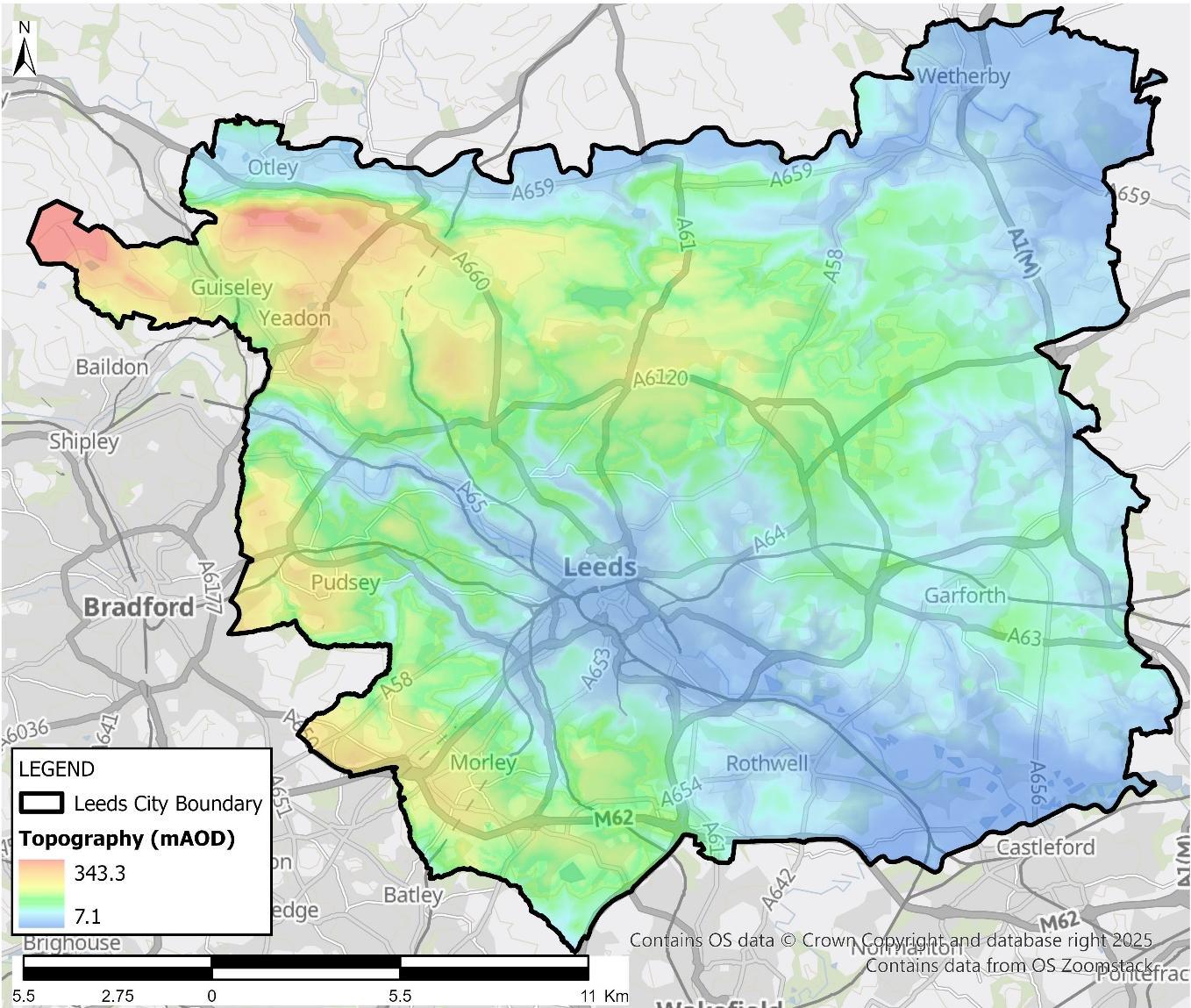
The city of Leeds is situated in the middle of the River Aire catchment and is characterised by varied topography, including steep-sided valleys and urbanised lowlands (Figure 1). In addition to the River Aire catchment, Leeds District also encompasses part of the River Wharfe catchment, along its northern boundary, while the River Calder lies adjacent to the District’s south-eastern boundary. Higher ground to the west slopes eastwards towards Leeds city centre, which occupies a relatively low elevation within the valley. The District is naturally drained by a network of watercourses, many of which are culverted in built-up areas. These watercourses generally flow eastward, eventually discharging into the River Ouse and Humber Estuary.
The city’s unique hydrological and topographical characteristics, combined with extensive urban development, contribute to a complex flood risk profile. The flood risk in Leeds District arises from a number of sources. Surface water, flooding from rivers (fluvial flooding), groundwater, flooding from the underground surface water pipe network (sewers) and a combination of any of these sources all contribute towards the overall picture of flood risk.
We as the LLFA, are responsible for managing local flood risks. Flooding that originates from Main Rivers, such as the River Aire, is not categorised as ‘local flooding’ and risk management responsibility for these watercourses sits principally with the Environment Agency However, the wider role of the LLFA requires us to lead the coordination of flood risk management. All flooding in Leeds is of concern to the residents and businesses of Leeds, as well as Leeds City Council. As such, this strategy promotes a collaborative approach to flood risk management in Leeds between all RMAs
Since there is no tidal influence on flooding in Leeds, this LFRMS does not address tidal flooding. Using information from the 2022 Leeds City Council SFRA, a summary of risks from all sources with exception to tidal follows. Refer to the 2022 SFRA for additional information on flood risk.
The five main sources of flooding in Leeds are outlined below:
- Main Rivers: This type of flooding typically occurs when a watercourse cannot cope with the water draining into it from surrounding land. Main Rivers are usually larger streams and rivers, but also include smaller watercourses of strategic drainage importance, which are not categorised as ‘ordinary watercourses’ These watercourses are defined on a ‘Main River Map’ designated by Department for Education, Food and Rural Affairs (DEFRA). The Environment Agency has permissive powers to carry out flood defence works, maintenance, and operational activities for Main River only.
- Ordinary watercourses: This type of flooding includes lakes, ponds or other areas of water which flow into an ordinary watercourse (not Main River). Flooding typically occurs when a watercourse cannot cope with the water draining into it from surrounding land.
- Surface water: This type of flooding occurs when rainwater does not drain away through the normal drainage system or soak into the ground but lies on, or flows over, the ground surface instead.
- Sewers: This Strategy only covers sewer flooding where it is wholly or partially caused by rainwater. This type of flooding occurs when sewers are overwhelmed by heavy rainfall, or they become blocked. The chance of flooding depends on the capacity of the local sewer system and amount of rain that falls.
- Groundwater: This type of flooding occurs when levels of water in the ground rise above the surface. It is most likely to happen in areas where the ground contains permeable rocks that water can soak into or pass through easily.
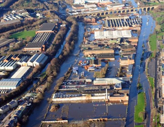
There are several Main Rivers in Leeds District including the River Aire, the River Wharfe and their contributing tributaries. These have historically been known to cause significant flooding to the communities that surround them, most notably in 2015 (refer to Figure 2). However, since then, a £200 million investment into the implementation and completion of the LFAS in November 2024 has significantly reduced fluvial flood risk to the River Aire corridor in Leeds. The Environment Agency’s Flood Map for Planning outlines the extent of fluvial flooding across the city.
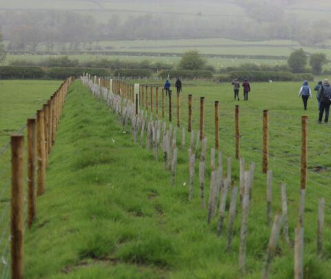
LFAS was developed to provide protection against a 1 in 200 -year flood event. Phase 2 of the scheme included the construction of linear defences along a 14 km stretch of the River Aire, a flood storage area, and NFM measures. LFAS is recognised as one of the largest and most innovative NFM projects in the UK, with these measures applied in the upper catchment by the Aire Resilience Company.
The Aire Resilience Company is a not-forprofit Community Interest Company which was created through a collaboration between Leeds City Council, Yorkshire Water, the Environment Agency, the RFCC, and the Rivers Trust. NFM approaches in the catchment used by the Aire Resilience Company include tree planting and improving land management (refer to Figure 3, Figure 4 and Figure 5) These measures help to intercept and better absorb heavy rainfall, slowing the flow of runoff into the Main River system. This is a great example of strong partnerships working together towards climate change resilience through catchment-wide, multi-benefit solutions.
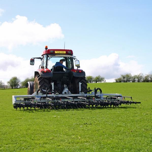
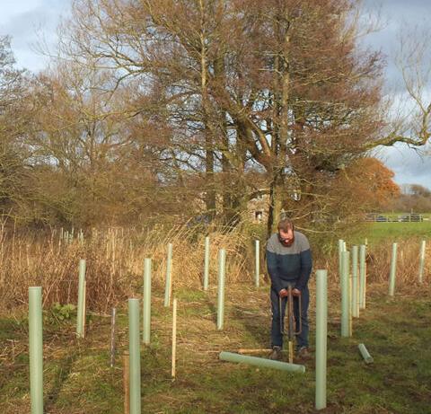
A number of small rivers, streams and ditches (also known as ordinary watercourses) also present a risk of fluvial flooding. These can often respond quickly to rainfall events and it is not always possible to accurately predict the extent of flooding that they may cause.
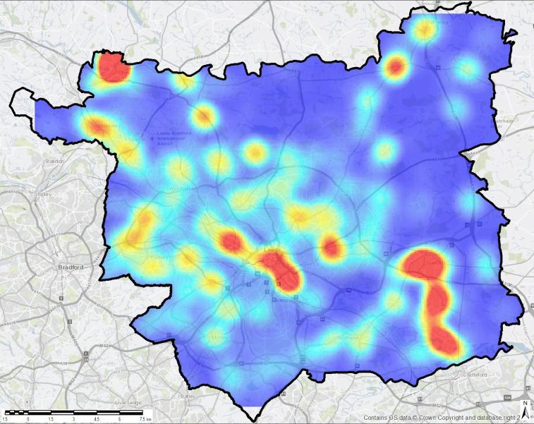
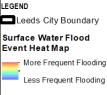
While significant progress has been made in understanding and managing risks from Main Rivers, particularly through the LFAS, surface water flooding remains less well understood and presents an ongoing challenge. Figure 6, obtained from the 2022 SFRA for Leeds, provides locations in Leeds most frequently impacted by surface water flooding. There is a good understanding of where the risk is located, however there is room to improve with managing this risk.
Often old public surface water sewers are not designed to accommodate for an increase in the volume of water due to climate change. Intense storms are likely to overwhelm systems and lead to flooding. In 2023 Yorkshire Water (as the statutory water undertaker) developed a Drainage and Wastewater Management Plan (DWMP), this helps to highlight the long-term needs and requirements of drainage, wastewater, and environmental water quality.
There are very few records of groundwater flooding in Leeds District, and the occasions when groundwater flooding was recorded are localised areas (one incident each in Beeston, Pudsey, Yeadon, Guiseley, Otley) which did not cause a significant risk to people and properties. The area’s most susceptible to groundwater flooding are localised along the River Aire and Wharfe valleys, however according to the 2022 SFRA for Leeds, the risk over most of the District is considered to be extremely low. It is recognised that the data used to assess this risk to date has been broad scale, the risk of groundwater flooding in Leeds is therefore not as well understood as the other risks at this time but is low in comparison to the risk of other sources.
The Leeds and Liverpool Canal and Aire and Calder navigation follow the course of the River Aire through the District. Overall, the risk of flooding from canals is low across Leeds and is associated mainly with fluvial flooding on adjoining watercourses. Recorded overtopping incidents are either localised or associated with major fluvial flood events (of which these flood mechanisms are represented in the hydraulic modelling of the River Aire) and the only breach event was associated with a 1 in 200 year flood event in December 2015. Most of the District is considered to be at a low risk of flooding from canals.
There are several reservoirs of varying sizes and capacity in the upper Aire and Wharfe catchments. The Environment Agency’s reservoir flood mapping provides the combined flood outline across Leeds for all these structures.
Flood risk is an increasingly important issue in the UK due to climate change. Projections indicate that the region will experience warmer, wetter winters, hotter, drier summers, and more frequent and intense rainfall events. These changes are likely to increase both the frequency and severity of flooding, which would not only pose a threat to city life but place a constraint on future planning and regeneration in the city. Underscoring the need for a robust, adaptive, and collaborative Vision and Strategy to manage flood risk
We utilise a range of funding sources and strong partnerships to deliver flood risk management measures. Since 2011 we have completed a total of 27 No. schemes and feasibility studies. Appendix A sets out the completed, ongoing, and planned flood risk management measures since 2011 The information presented provides a snapshot of progress up to 2025 (the time of writing this LFRMS). However, the list is a living document and is regularly updated as new opportunities arise and measures progress
For information on existing flood risk assets in the District of Leeds, access the Leeds City Council online interactive mapping
Leeds City Council envisions a city where people, businesses, and the environment thrive without the persistent threat of flooding. By embracing innovation, collaboration, and sustainability, we aim to establish Leeds as a global leader in flood resilience for all sources of flood risk Whilst most flood schemes tend to focus on fluvial risk, it is important to also mitigate increasing surface water risk through the incorporation of SuDS and Blue Green Infrastructure(BGI) OurboldStrategyfocusesonthreekeypillars:protection,preparation,andpartnership.
Wewillinvestincutting-edgeinfrastructurethatnotonlymitigatesfloodriskbutenhancesthecity’sgreenandblue spaces. Building on the success of the LFAS, we will deliver pioneering projects, such as adaptable flood defences, enhanced NFM solutions, and the integration of sustainable drainage systems (SuDS) across urban and rural developments, highways and public realm schemes. These interventions will balance robust protection with the preservationofbiodiversity, amenity andcarbonreductiongoals.
Leedsiscommittedtoaproactiveapproachtoclimateadaptation.Wewillembedflood&climateriskmanagement into all aspects of urban planning and regeneration. Utilising predictive analytics and advanced hydrological modelling, we will identify future risks and prioritise investments. Education and community engagement will empower residents and businesses to prepare for and recover quickly from flood events. This includes clear communication plans, accessible tools for self-assessment, and inclusive support programmes for vulnerable communities.
Flood risk management requires a united effort. Leeds City Council will foster dynamic partnerships with governmentagencies,academia,theprivatesector,andlocalcommunities.Together,wewillunlockfunding,share expertise, and develop transformative solutions. Our commitment to co-creation will ensure that the voices of our citizensarecentraltoshaping aresilientLeeds.
By 2030, Leeds will stand as a model city for flood resilience, with minimised flood damage, a thriving ecosystem, and communities confident in their safety. The Council will lead by example, ensuring all actions align with our broader climate and sustainability objectives. Leeds City Council is ready to tackle the challenges of today and tomorrow, securing a future where floods no longer define the city’s narrative but demonstrate its resilience, adaptability, and ambition.Together, wewillbuildasafer,stronger, andmoresustainableLeeds.
Effective flood risk management in Leeds relies on strong, collaborative partnerships across organisations. Partnership working ensures that decisions are informed by a wide range of expertise, local knowledge and shared priorities. It is therefore essential that new and existing collaborations promote equality between partners, prevent larger organisations from dominating and avoid siloed thinking that can hinder progress.
Leeds City Council will continue to support a non-statutory partnership bringing together public bodies responsible for surface water management, water quality, flood risk investment planning and economic development. Flood risk responsibilities are spread across multiple organisations, each with statutory duties, priorities and funding mechanisms. This fragmentation can hinder coordinated action. Early engagement, transparency, and information sharing helps build trust, overcome inequities within the partnership and align polices and funding cycles. Leeds City Council can also ensure that flood risk management is resilient, innovative and responsive to the city’s future challenges. To strengthen partnership working, Leeds City Council will do the following (refer to Figure 7).
clear roles and responsibilities for all partner groups, particularly technical and decision-making teams
Rotate leadership roles to encourage inclusivity and shared ownership across partners.
Increase visibility and transparency of partnership activities by sharing knowledge, outcomes, and lessons learned to promote best practice governance.
Embed flood risk considerations early in regeneration and spatial planning, ensuring that the wider community is engaged and informed to support sustainable decisionmaking.
Acknowledge the investment of time, resources, and commitment required to establish and maintain strong partnerships. Building trust, sustaining engagement, and managing changes in personnel all require ongoing effort and organisational support.
Plan for long-term funding and adaptability, ensuring projects can evolve in response to changing risks associated with the climate emergency.
Embrace diversity within the partnership of stakeholders, expertise, and experience to improve creativity, inclusivity, and project success.
While Leeds City Council, as LLFA takes the lead in coordinating flood risk management across the District, several other authorities also play key roles in managing flood and water related risks These partners, who hold formal or statutory responsibilities under the FWMA, are collectively known as RMAs Within Leeds District, there are six designated RMAs Table 2 outlines each authority and their respective responsibilities in relation to flood risk management
Table 2 Responsibilities and duties for managing flood risk in Leeds District, Credit: Leeds City Council SFRA 2022
KeyResponsibilities ofDifferent Authorities
Fluvial Flooding from Main Rivers
Fluvial Flooding from Ordinary Watercourses
Water
Flooding
Leeds City Council
Leeds City Council’s principal responsibilities as LLFA under the FWMA and FRR are summarised below. The following responsibilities supplement any existing duties under the Land Drainage Act 1991.
- Local Flood Risk Management Strategy: Develop, maintain, apply and monitor a Strategy for managing local flood risk in Leeds District.
- Preliminary Flood Risk Assessment: Report on historic, current and future understanding of flood risk for Leeds District; review and consider changes to FRAs. An update is required every six years, with the last update submitted to the Environment Agency on the 22nd June 2017.
- Co-operation & Arrangements: Co-operate with other RMAs in exercising their flood risk management functions under both the FWMA and the FRR.
- Power to Request Information: Request a person to provide information in connection with the authority’s risk management functions.
- Duty to Maintain a Register: Establish and maintain a register of structures and features, including ownership, which are believed to have a significant effect on a local flood risk.
- Flood Risk Management Works under general powers: Undertake works to manage flood risk from surface runoff, groundwater and ordinary watercourses (all works must be consistent with the LFRMS).
- Flooding Investigations: Investigate flooding incidents in the District, to the extent that it is considered necessary or appropriate, and in cooperation with other RMAs where appropriate.
- Sustainable Development: Contribute towards sustainable development through flood risk management activities.
- Incidental Flooding: Plan, erect, maintain, alter or remove buildings or other structures (including those used for flood defence purposes) that will or may cause flooding, an increase in the amount of water below ground, or coastal erosion.
The Environment Agency is an executive, non-departmental public body responsible to the Secretary of State for Environment, Food and Rural Affairs (DEFRA). Its principal aims are to protect and improve the environment, and to promote sustainable development. The Environment Agency take lead responsibility for risk-based management of flooding from Main Rivers and the sea and regulation of the safety of reservoirs with a storage capacity greater than 25,000m3. The FWMA proposed an amendment to the Reservoirs Act to target a reduction in the capacity at which reservoirs should be regulated from 25,000m3 to 10,000m3; however, this reduction is yet to be implemented in England at the time of writing.
The following roles and responsibilities are set out for the body within the FWMA:
- Development of a National Strategy for FCERM to cover all forms of flooding.
- The conversion of Regional Flood Defence Committees into Regional Flood and Coastal Committees with a new remit to include coastal erosion issues.
- Powers to request information from any person in connection with the Environment Agency’s Flood and Coastal Erosion Risk Management functions.
- Power to designate structures and features that affect flooding or coastal erosion.
- Powers to cause flooding and erosion for nature conservation and cultural heritage reasons, and people’s enjoyment of these assets.
- A duty to consider FCERM in carrying out other work that may affect FCERM.
- A duty to consider the LFRMS.
- A duty to report to Ministers about FCERM, including application of the national strategies for England and Wales.
- Act as a statutory consultee to the SuDS approving body on sustainable drainage that impacts water quality or strategic flood risk.
The Environment Agency published the National Strategy for FCERM in 2011, and it was last updated in 2022. It sets out a national framework for managing the risk of flooding and coastal erosion and describes the roles and responsibilities of management authorities and communities. It has a significant impact upon LLFAs, as it communicates their duties under the FWMA.
The National Strategy includes:
- An overview of flood and coastal erosion risk in England.
- A long-term, strategic ambition for managing flood and coastal erosion risk in England.
- The high-level measures proposed to achieve that ambition.
- The contribution these will make towards the government’s wider environmental objectives.
- How and when the Strategy will be reviewed.
YWS is the sole Water and Sewerage Company (operating in Leeds District. As a provider of water infrastructure services, the company have existing responsibilities in relation to FCERM in Leeds District, which were supplemented by the FWMA. The following responsibilities were provided by YWS in the previous iteration of the LFRMS:
- Where appropriate assist LLFAs in meeting their duties in line with the National FCERM Strategy for England and guidance.
- Where appropriate assist LLFAs in meeting their duties in line with local strategies in their area.
- Where appropriate share information and data with RMAs, relevant to their flood risk management functions.
- A duty to effectually drain their area, in accordance with Section 94 of the Water Industry Act 1991.
- A duty to register all reservoirs with a capacity greater than 25,000m3 with the Environment Agency.
- Agreement with Ofwat to maintain a register of properties at risk from hydraulic overloading in the public sewerage system (DG5 register).
- Appropriate management of surface water in combined sewer systems.
- Encourage the use of SuDS.
- Create a detailed understanding of flood risk from the public sewer system.
- Explore and implement multi benefit/agency schemes.
The following priorities were provided for West Yorkshire:
- Appropriate management of surface water from the combined sewer system.
- Encourage the use of SuDS.
- Where appropriate share information and data with RMAs.
- Create a detailed understanding of flood risk from the public sewer system.
- Explore and implement multi-agency and multi-benefit schemes to resolve issues within the company’s appointed business.
Ainsty IDB are the sole IDB operating in Leeds District and cover only a very small percentage of Leeds District (in the Wetherby area) and, as such, its role is limited. Under the FWMA, Ainsty IDB have new duties and responsibilities supplementing their existing powers. Their key powers and responsibilities are:
- Power to designate structures and features that affect flooding or coastal erosion.
- A duty to exercise their functions in a manner consistent with local and national strategies.
- Duty to be subject to scrutiny from the LLFA’s democratic processes.
- The ability to work in consortia with other IDBs.
- Statutory consultee to the SuDS approving body on sustainable drainage that impacts land drainage.
- Power to do works on ordinary watercourses causing flooding within their boundary.
As a highway authority, National Highways manage major trunk roads and motorways in Leeds District including the M621, M62, M1 & A1. Their responsibilities in relation to flood risk management are listed below.
- Provide and manage highway drainage and roadside ditches under the Highways Act 1980.
- A duty to exercise their functions in a manner consistent with local and national strategies.
Other authorities and stakeholders, with no designated role under the FWMA, also have a key responsibility for flood risk management in their own areas of discipline as listed below.
- Network Rail.
- Canal and River Trust.
- Met Office.
- Natural England.
- English Heritage.
- Association of British Insurers.
- Local flood partnerships, forums and community groups.
It is expected that these authorities will undertake their activities in a manner that is consistent with this Strategy.
Organisations such as the Yorkshire Wildlife Trust and the Aire Rivers Trust are often key partners in catchment partnerships and delivery of NFM. Shared goals between organisations and this LFRMS encourage strong collaboration between partners to achieve them. Coordinated work towards project bids could also help to drive more funding and investment into the project.
Climate Commissions are independent advisory boards which support, guide, and mobilise climate action across the region. They bring together people from the public, private and third sectors who work collaboratively with the local authority on projects that contribute towards meeting climate reduction targets and the delivery of enhanced climate resilience. Commissions also act as a forum where organisations can exchange ideas, research findings, information and best practice on carbon reduction and climate resilience.
In September 2022 the Yorkshire & Humber Climate Commission published an update to their Climate Action Plan. The following two objectives within the Plan strongly align with the Vision in this LFRMS:
- Protecting people and nature in a changing climate
- Managing our land and water so it benefits us all
Leeds Climate Commission are responsible for leading and coordinating work around the ‘Resilient’ ambition as part of the Leeds Ambitions initiative. A goal related to flood risk underpinning this Ambition is to ‘improve the resilience of our people, communities, businesses and services to the changing climate, restoring our connection with nature and creating quality green space where people can be active’.
The Yorkshire Integrated Catchment Solutions Programme (iCASP)
This organisation which is part of the University of Leeds, works to develop a strong and sustainable regional community to pioneer a more integrated approach to catchment management, they work on activities such as:
- Sharing knowledge nationally and internationally
- Supporting organisations by addressing gaps in research needed to secure funding
- Providing a scope for work that is going out to tender
- Managing consultations or workshops or sourcing information to strengthen bids
- Advocating for increased investment in the region.
The LFRMS is approved at various Leeds City Council board meetings, as per the Council’s standard policies and procedures. As well as our RMA partners, there are many different service areas of the Council that have an important role to play in managing the reduction of flood risk. For example, the Flood and Climate Resilience Management (FCRM) team utilise their expertise and live information from external partners, such as the Environment Agency, to work with internal partners such as the Resilience and Emergency Team (RET). This ensures we are making a holistic response to the potential flood event and also opportunity for the FCRM team to review and comment on emergency flood evacuation plans.
Owners of land adjoining a watercourse have certain rights and responsibilities and are legally referred to as ‘riparian owners ’ Riparian owners play a key role in building strong partnerships and effective collaboration with riparian owners can be critical to the success of flood risk management projects. For additional information on the rights and responsibilities of riparian owners refer to Owning a Watercourse, guidance published by the Environment Agency
To implement this LFRMS successfully, it is important to understand and plan how to fund its delivery. The majority of the work that we do is required by law, but there are many potential funding opportunities for all of our flood risk management activities including capital, revenue, national, local and private sources. The largest proportion being that received from central government. By utilising a mixture of all of these sources, we can maximise the amount of flood risk management activity we can undertake and go above and beyond just that which is required by legislation. A summary of the funding sources available is provided in Table 3
Table 3 Funding Sources
Source of funding Description
FCERM Funding Central government funding for flood (and coastal) defence projects. The government has committed £10.5 billion to flood defences to protect nearly 900,000 properties. From April 2026, all prioritised flood projects valued at £3 million or less are eligible for full funding by the government. Prioritised projects valued higher than this will be eligible for the first £3 million of support upfront, and 90% of the costs thereafter.
Local Levy Annual contributions from Councils to a regional ‘pot’. It is smaller than the FCERM GiA budget but offers more flexibility on the type and size of project it can fund.
Private contributions Voluntary, but funding from beneficiaries of projects could make contributions from national funding viable. Not just restricted to members of the public, Electricity and other service providers, local businesses and landowners are potential beneficiaries of flood risk management activity.
Water company investment
Section 106 contributions (Town and Country Planning Act)
Investment is heavily regulated by Ofwat, but there are opportunities for contributions to area- wide projects which help to address sewer under-capacity problems.
Contributions from developers linked to specific development sites, where off-site improvements to drainage infrastructure are required to make the developers proposals acceptable
Administered by Appropriate for
Environment Agency Medium to large capital FRM projects.
Environment Agency Smaller FRM projects, or as a contribution to FCERM GiA projects.
Leeds City Council All projects
Yorkshire Water Services Limited Projects that help to remove surface water from combined sewers.
Leeds City Council Larger development sites.
Source of funding Description
Community Infrastructure Levy (CIL)
Developer contributions
A local levy applied by the Planning Authority on developers to contribute to a general infrastructure fund. A bid for CIL must be made for flood management or drainage improvements against other competing Council priorities.
Where a developer, as part of their proposals, construct works for flood alleviation. These can be separate schemes, part of a larger scheme or contributions in kind i.e. land
Council Tax Aring-fenced provisionwithin the annual Council taxfor the specific purpose of contributing to FRM
Business rates supplements Agreement from local businesses to raise rates for specified purposes
Council capital funding The Council’s infrastructure programme, which prioritises capital improvement projects. The programme has included funding for drainage capacity improvements for many years, which is targeted at the highway drainage systems.
Council revenue funding The Council has a number of revenue streams to support technical and admin processes and to maintain Council infrastructure. Existing revenue budgets include highway drainage maintenance, watercourse maintenance and funding for the Flood Management Team discharging the LLFA duty for the Council.
Leeds City Region Enterprise Partnership (LEP)
A business-lead partnership between local authorities, businesses and, in some cases, representatives from academic institutions. The LEP works closely with the WYCA to deliver a shared Strategic Economic Plan for Leeds City Region in West Yorkshire.
WYCA Established in April 2014 as a WYCA authority with powers over transport, economic development and regeneration for five local authorities. It is the body responsible for delivering large-scale infrastructure projects in Leeds City Region. Works closely with the Leeds City Region Enterprise Partnership (LEP) to deliver a shared Strategic Economic Plan for Leeds City Region in West Yorkshire.
Local Growth Deal WYCA and the LEP secured £1 billion Local Growth Deal for Leeds City Region to deliver their shared Strategic Economic Plan.
Heritage Lottery Fund (HLF)
£19.7m of National Lottery funding HLF since 2017 to improve understanding and management of water landscapes. £2-3 million per scheme. Landscape Partnership schemes work with local, regional and national partners to promote a catchment approach to water management by engaging people, communities and landowners to improve water management
Administered by Appropriate for
Leeds City Council All measures outlined in this Strategy.
Leeds City Council Development.
Leeds City Council Not current. There is potential to deliver key objectives in this Strategy.
Leeds City Council Measures that address flood risk to businesses.
Leeds City Council Measures which are small to medium capital projects.
Leeds City Council Measures requiring officer time and/or maintenance activity.
LEP Seeks partnership to strategically drive economic growth; jobs and skills; inward investment; infrastructure; and business growth.
WYCA Works with the LEP and other local partners to ensure our region has the right transport, housing and environment to meet the needs of businesses and our economy.
WYCA / LEP Strategic Economic Plan
Schemes awarded funding focus on using nature and heritage to provide opportunities for communities within post- industrial landscapes, from skills training and educational opportunities, to boosting tourism and local business promoting heritage-led regeneration.
The development of our updated Strategy has been shaped by a set of themes that build upon the key pillars set out in our Vision, reflecting our core principles and priorities These themes informed the revision of objectives from the previous LFRMS. To ensure clarity and consistency, we have introduced a set of icons, each representing a guiding theme. These icons are used throughout the Strategy to categorise and highlight the themes relevant to each objective.


Innovation (Vision 1)
Aligning with Leeds ambition to be a global leader in flood management
Climate Resilience (Vision 2)
Preparing for future challenges, and embedding a catchment wide approach
Partnership (Vision 3)
A culture of shared responsibility, ensuring effective delivery and oversight
A key aspect of our work is assessing the risk posed by flooding. For the Strategy, and therefore the work we do, risk is defined as:
The definition of these terms is fundamental to our work and how we prioritise our work.
This LFRMS is set out such that our Vision represents the long-term aspiration for flood resilience in Leeds, and for consistency, aligns with the three long term ambitions in the National Strategy:
- Climate resilient places
- Today’s growth and infrastructure resilient in tomorrow’s climate
- A nation ready to respond and adapt to flooding and coastal change
This section describes the objectives and measures that form the basis of our Strategy. Guiding the city’s approach to achieving the Vision and informing future local flood risk management plans and actions. The objectives are listed below.

Objective 1: Champion innovative and affordable approaches to flood protection

Objective 2: Embed flood & climate risk resilience in all aspects of urban planning and regeneration
Objective 3: Strengthen collaborative partnerships
Objective 4: Enhance organisational capability and whole life delivery of flood risk management
Objective 5: Engage and empower communities in flood risk awareness and decision-making
Objective 6: Improve evidence-based understanding and delivery of flood risk solutions


Establish Leeds as a global leader in flood resilience. Invest in cutting-edge multifunctional flood risk solutions that deliver environmental, social, and economic value.
Deliver pioneering projects that integrate with wider urban planning and climate goals, including Blue-Green Infrastructure, NFM and SuDS, to maximise benefits and long-term sustainability.
Make flood risk management approaches proportionate and risk based
Flooding can never be prevented altogether. To try and do so would be technically infeasible, environmentally damaging and uneconomical. A risk-based approach to managing flooding targets investment to areas where the risk is greatest by examining both the likelihood and consequences of a flood occurring. Flood risk management activities should be proportionate to the risk that is faced
Innovation and multiple benefits
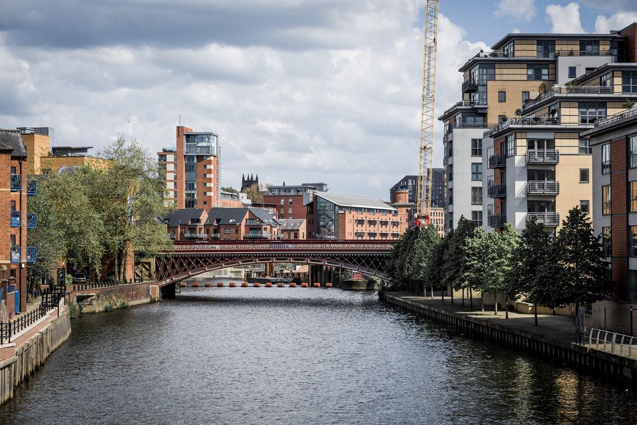
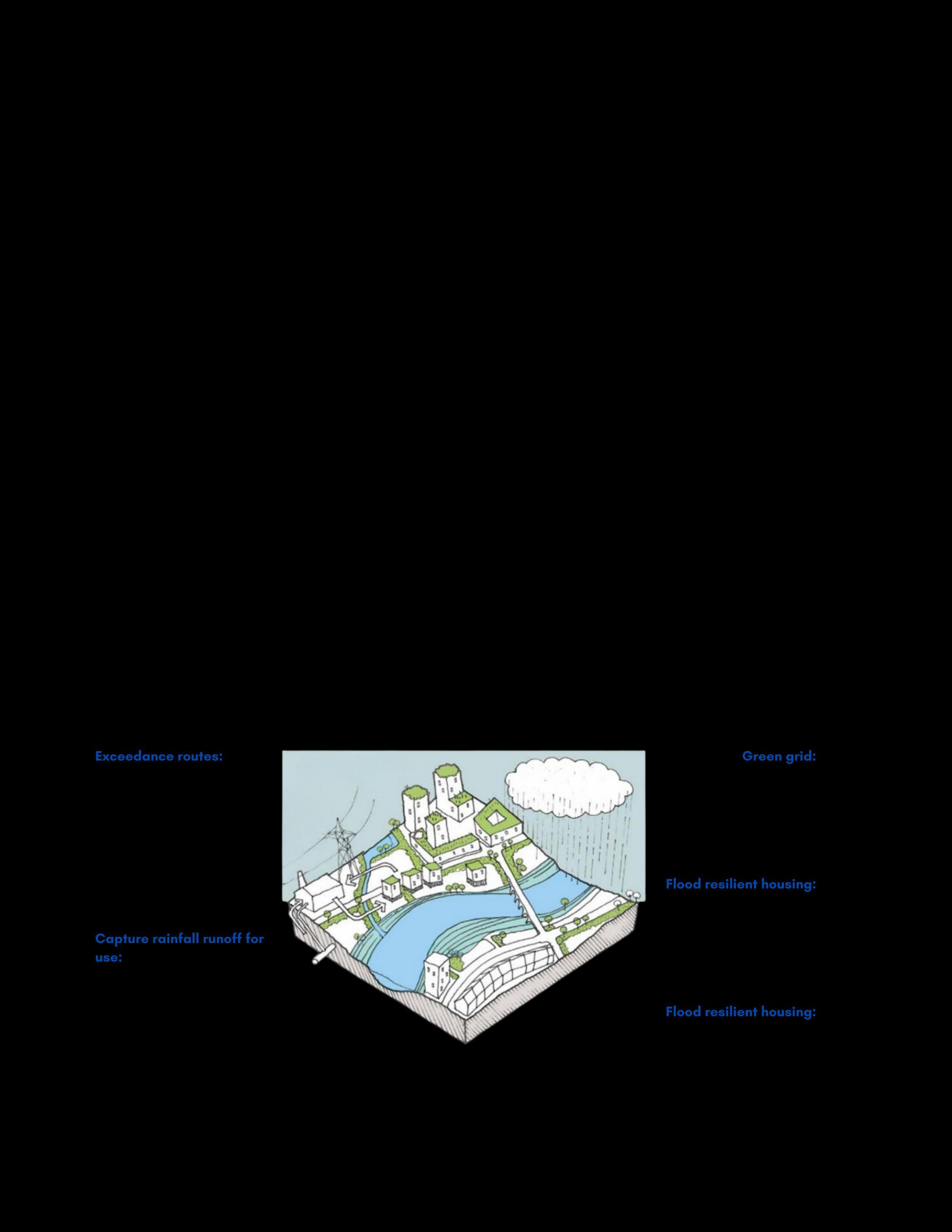
Incorporating flood risk management measures into all aspects of urban design can unlock a range of benefits and make use of brownfield sites, as demonstrated through the principles of Water Sensitive Urban Design and displayed in Figure 8. As described in the National Planning Policy Framework (NPPF), it is important that in all situations we firstly seek to avoid development within flood risk areas Figure 8 demonstrates that incorporating water sensitive design in locations not directly at risk can collectively help reduce flood risk across the wider District, contributing to the concept of a ‘sponge city’
Leeds City Council is committed to driving meaningful change in how drainage of new developments is both planned and implemented, as well as incorporating retrofit solutions to improve flood risk to existing properties. We seek to realise the opportunities of SuDS by promoting the approach and incorporate ecosystem services where possible as well as addressing the barriers to their use.

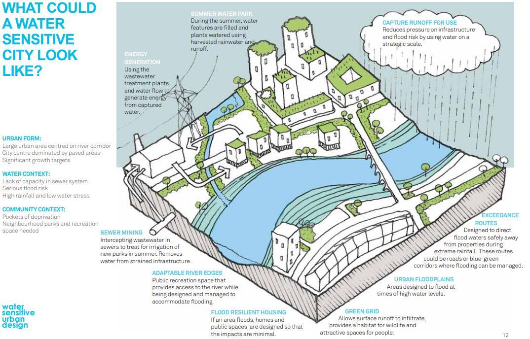
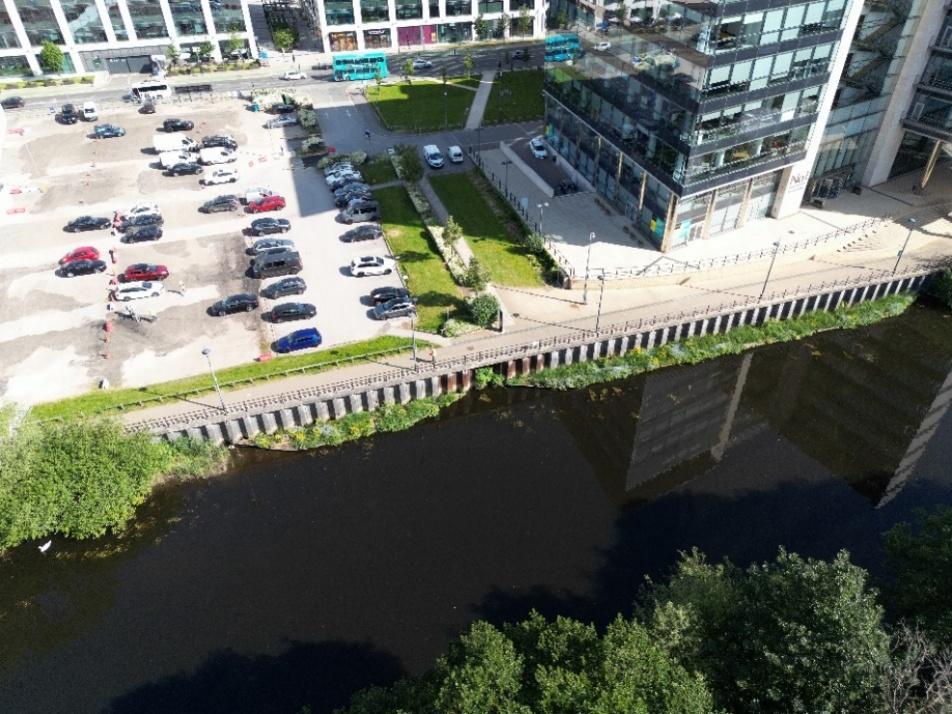
Innovative measures can also be seen closer to home in Leeds (refer to Figure 11) The implementation of floating vegetated riverbanks on the River Aire near Leeds train station aligns with wider water environment goals compliant with the Water Framework Directive (WFD) by providing an excellent habitat for fish, invertebrates, and birds, while also slowing river velocity near the banks, helping to limit erosion during storm events.
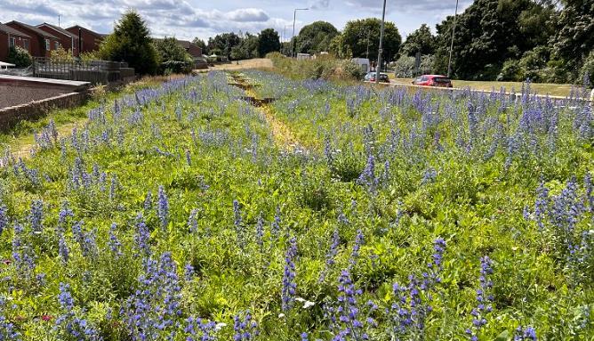
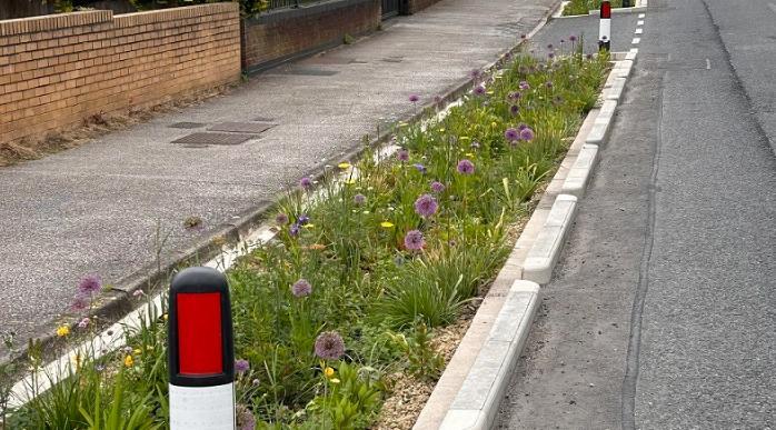
An example of where SuDS has been successfully implemented can be seen in Mansfield, as part of the Sustainable Flood Resilience project (refer to Figure 9 and Figure 10). These nature based solutions such as rain gardens, bioswales, and permeable paving, were designed to help the town’s sewer networks cope better during bad weather by storing rainwater or, allowing it to infiltrate into the ground after a rainfall event. According to Mansfield District Council, a total of 343 SuDS were installed, adding over 31 million litres of capacity to the sewerage network.
Alongside the primary purpose of SuDS, these interventions have wider benefits which include, but are not limited to, improving water quality by reducing the impact of diffuse pollution, improving biodiversity through habitat creation, and enabling development by freeing up capacity in established drainage networks.

Promote adaptive, climate resilient flood management practices into all aspects of urban planning and regeneration to enable growth and ensuring alignment with UK policy and guidance.
Champion sustainable catchment-based approaches and encourage a culture of shared responsibility among stakeholders to proactively futureproof and improve climate change resilience.
Development planning applications are assessed for compliance with the NPPF. The NPPF makes clear that inappropriate development in areas at risk of flooding should be avoided by directing development away from areas at highest risk from all sources Development must therefore be carefully regulated, with the application of the Sequential and Exception tests where relevant, and measures put in place to maintain safety throughout the lifetime of the site.
To ensure development is climate resilient, the flood risk to and from new sites must be appropriately assessed and managed with an allowance for climate change. It is essential to consider how development may increase flood risk, but when effectively managed, new development can contribute to reduce existing flood risk to the District, creating a ‘sponge city’. Given the surface water flood risk facing Leeds, we are committed to promoting such reductions, with Water Sensitive Urban Design playing a key role
We are committed to working collaboratively with internal partners within Leeds City Council to maximise resources and ensure a co-ordinated approach. At the time of preparing this LFRMS a new Local Plan is under development and this objective within the LFRMS aligns strongly with the emerging Local Plan’s objective for flood risk:
‘To ensure that new developments are located and designed to reduce and mitigate flood risk, and manage water, taking into account the impacts of climate change. ‘
A sustainable approach also involves coordinated planning, with developers working in partnership with RMAs to ensure flood risk is consistently addressed and catchment wide strategies are supported.
SuDS play an important role in BGI initiatives and are a key method for achieving Water Sensitive Urban Design The national guidance on SuDS (2025) outline three themes which underpin the standards:
Surface water drainage systems should follow a natural approach that mimics natural processes, manages runoff close to its source, and uses a combination of surface-based, vegetated features to deliver sustainable, multi-benefit outcomes for people, wildlife, and the environment.
Surface water management should be integrated from the earliest stages of appraisal, planning, and design, aligning with natural drainage patterns, existing site features, and wider environmental infrastructure strategies.
All relevant planning applications should demonstrate how the SuDS approach has been integrated from the earliest design stages, ensuring compliance with national standards across all phases of development to maximise long-term performance.
As highlighted by the National SuDS Standards, achieving multiple benefits is key. This is demonstrated by the following case study from Otley.

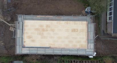

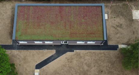
Following the successful completion of the Otley Flood Alleviation Scheme we were offered additional funding to improve flood resilience and undertake SuDS projects at two schools in the Otley area Figure 12 and Figure 13 show the installation of a green roof on one of the school buildings as part of the projects. Recent anecdotal evidence shows that the roofs have performed well during thunderstorms, with little runoff, and have worked to limit surface water flooding.
Further reported benefits include improved building insulation, keeping the building cooler in the summer and warmer in the winter, and improved biodiversity with an increase in the number of bees observed The green roof project is planned to be included in education programmes at the school to increase awareness and learning regarding environmental factors and the impacts of climate change. Presentations from teams who worked on the projects have been delivered to over 30 schools to improve understanding of flooding and flood schemes.
An example of embedding climate resilience into urban planning is illustrated by the Glasgow Smart Canals project which utilises an existing asset (the Forth and Clyde Canal) as part of the drainage infrastructure to manage flood risk and surface water in an urban environment (refer to Figure 14, Figure 15, and Figure 16). The canal’s storage capacity is used during extreme rainfall events to hold stormwater by lowering the water level in the canal preceding an event. According to a paper published by CREW (2016), a clear governance structure between partners was key to the project’s success, unlocking approximately 260 hectares of brownfield land (Concept (2013) and Design (2017) by AECOM).
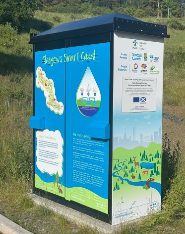
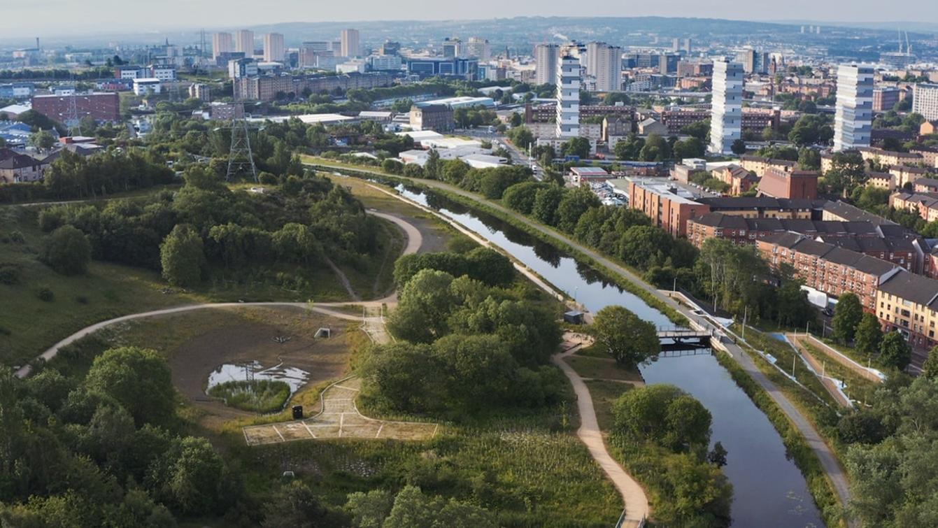
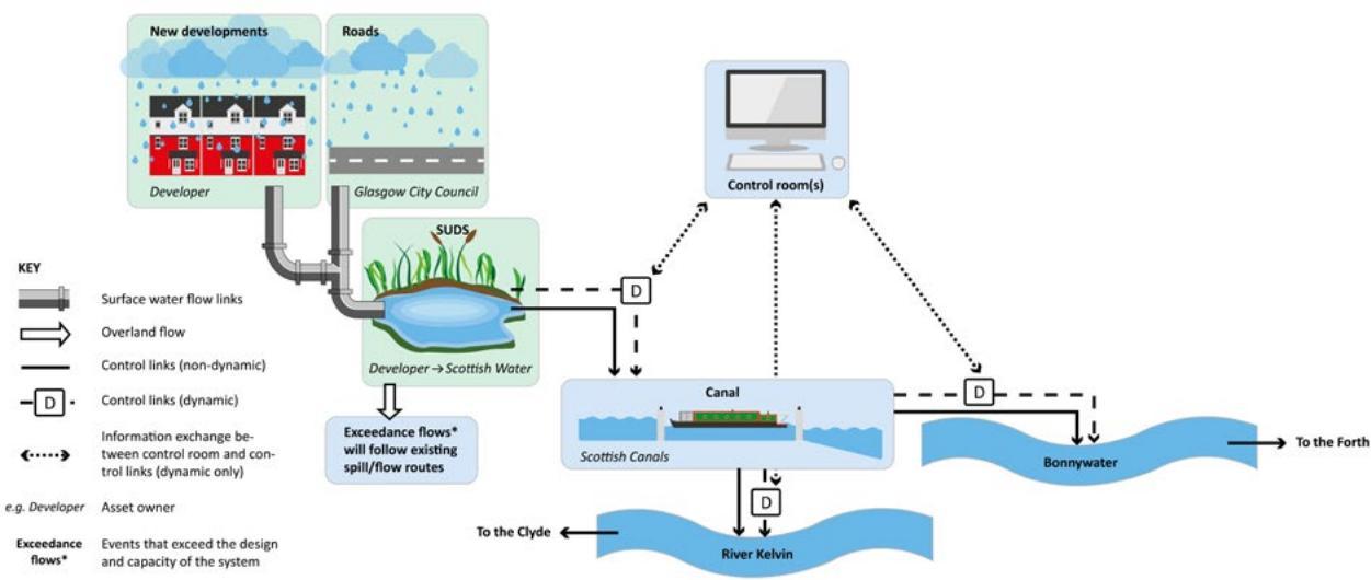

Foster dynamic partnerships with effective cooperation with government agencies, academia, the private sector, and local communities through clear procedures and shared responsibilities, ensuring alignment with new legislation.
Deliver holistic (catchment wide) solutions to identified risks and problems such as emergency planning.
An essential component of flood risk management is partnership working. It is recognised that many of the RMAs and stakeholders listed in the LFRMS will have established policies and procedures for managing flood risk issues or responding to flooding incidents; partnership working would not seek to replace these established procedures, rather it will help the stakeholders to improve communication, build relationships and over time, align relevant aspects of their work.
There are also many stakeholders without formal roles in the FWMA that can also influence flood risk and help to manage it, broader partnership working arrangements than just between RMAs are encouraged. The more stakeholders can find opportunities to work together, the better use will be made of funding, resources and expertise.
Flooding is often the result of a combination of factors and rarely stops at an administrative boundary. There may also be instances where responsibility is not clear or overlapping, so a flexible and responsive approach will be required to manage risk effectively in the short, medium and longer term. It is also recognised that not all stakeholders will be required to be involved with all aspects of the work, for example, transport providers and utility companies will be interested in managing flood risk in terms of its effect on their infrastructure or facilities, rather than in managing flood risk in full detail. Having some high-level commitment to partnership working within the main stakeholder organisations will be important, but direct partnership working between stakeholders, with the LLFA generally acting as the connection between, will in most cases be more efficient than seeking to develop a single broad holistic partnership and engage stakeholders in work that has no relevance to them.
It is acknowledged that barriers to the adoption of BGI such as SuDS still exist. Adopting authorities are often cautious about innovative projects due to perceived risks associated with alternative flood management approaches. Common concerns include uncertainty around long-term maintenance requirements and the challenge of achieving effective community engagement. However, beyond flood risk reduction, SuDS deliver a wide range of additional benefits, including enhanced biodiversity and improved air and water quality, all of which are key to building climate resilience As demonstrated by the case studies presented in this LFRMS, which showcase successful implementation of BGI across the UK, adoption is becoming increasingly widespread. These examples highlight growing recognition of the multiple benefits of BGI, providing greater confidence for future integration
An important part of dealing with the risk of flooding is making sure there is an effective response to incidents when they do happen. As a LLFA, we have a number of initiatives already in place to deal with flood emergencies. We receive Flood Guidance Statements and Severe Weather Warnings from the Flood Forecasting Centre about forthcoming rainfall events, derived from data collated by the Met Office and the Environment Agency; these warnings are cascaded to each LLFA team. As part of a comprehensive emergency response, we seek to work closely with partners to support those who are affected by flooding. In addition, as mentioned under the Partnership Working section in his document, it is important that Leeds City Council’s Resilience and Emergency Team (RET) have the opportunity to review and comment on Emergency Access Plans for new development in flood risk areas.

Promote a coordinated, long-term approach to flood risk management that considers wholelife costs, maintenance responsibilities, and sustainable outcomes.
Ensure that implemented assets are supported throughout their lifecycle by collaboration and a culture of shared responsibility for flood risk management across Council departments and RMAs
Simultaneously, increase internal skills to build the technical and strategic capacity for flood risk management.
It is important that flood risk management activities are coordinated, and decisions are made in an open, honest and accountable way. To achieve this, working groups, advisory boards and decisionmaking groups could be set up to form a robust structure of governance. Authorities across the region should play an important role in these groups as it is essential to consider the entire catchment and recognise that activities of neighbouring authorities have an impact on each other.
The structure should be set up so that the right people are working together at an appropriate level to ensure effective working practices are technically robust and consistent with wider strategic plans and objectives. Within this structure technical groups made up of flood risk practitioners would be able to discuss best practice and provide potential solutions to problems.
Maintenance of flood risk management assets is vital to ensure they function as designed, and reduce the risk of blockages that could result in flooding to properties. Physical works such as maintenance and infrastructure improvements have well defined costs and it is possible to estimate the benefits of this type of work.
In contrast, more non-tangible activities can be more challenging to quantify monetary benefits Nonetheless, actions such as maintaining a comprehensive register of flood risk assets offer significant value by improving our understanding of flood risk across the city Information on existing flood risk assets is accessible through Leeds City Council online interactive mapping A proactive approach to identifying defects and potential problems in existing assets allows for timely interventions, ensuring that issues are addressed before they escalate.
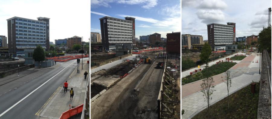
The Sheffield grey to green initiative is a very inspiring example of how BGI can be integrated into urban design while also addressing the whole-life maintenance of flood management assets Developed in response to the floods in June 2007, the project sought to reconnect parts of the city centre, repurpose a highway, and strengthen resilience against future flooding.
Led by Sheffield City Council in collaboration with landscape architects, sustainable urban design specialists, and ecological management companies, the initiative transformed former roadways into pedestrian friendly areas and a vibrant green corridor (Figure 17) The project relied on nature-based solutions, including SuDS to manage rainwater and reduce surface runoff
Planters were used as part of the SuDS, and careful consideration given to every stage of their design. The soil used was a blend of locally recycled materials, chosen to support drought resistant planting and ensure durability over the whole life of the assets (Figure 18) These planters not only capture rainwater to slow runoff but also provide ecological benefits by incorporating pollen rich plants that support bees, which are vital to the food chain.
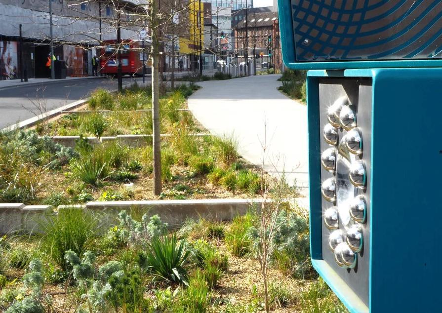
The planting strategy was multilayered, offering additional environmental gains. Vegetation helps filter air pollutants, contributing to carbon reduction, and enhanced biodiversity. At the same time, the corridor created attractive public spaces that improved connectivity, encouraging active and sustainable travel, and fostering pride in the community.

Empower communities with confidence in their safety by enhancing public understanding of flood risk and the LLFA’s role in managing it.
Actively involve communities in flood preparedness through improved awareness and actions that prepare individuals, homes and businesses to reduce their vulnerability.
This approach contributes to more resilient, informed communities.
Some people and communities are already very aware of the flood risk they face and have taken action in their own area; particularly those that have experienced flooding first hand. Others may not be aware of the risks in their area, are not sure how to find out about the risk, or what action they can take.
There are several ways people can manage flood risk to their homes and businesses through active citizenship, without relying on the action of authorities. One of our aims is to help people understand what they can do and what works effectively. We can also learn a lot from these communities that have first-hand experience of flooding, and it is essential that we understand their concerns and priorities so that we can manage these appropriately and successfully.
People taking an active role in the community to help manage or reduce the risk of flooding, such as clearing leaves from drainage gullies.
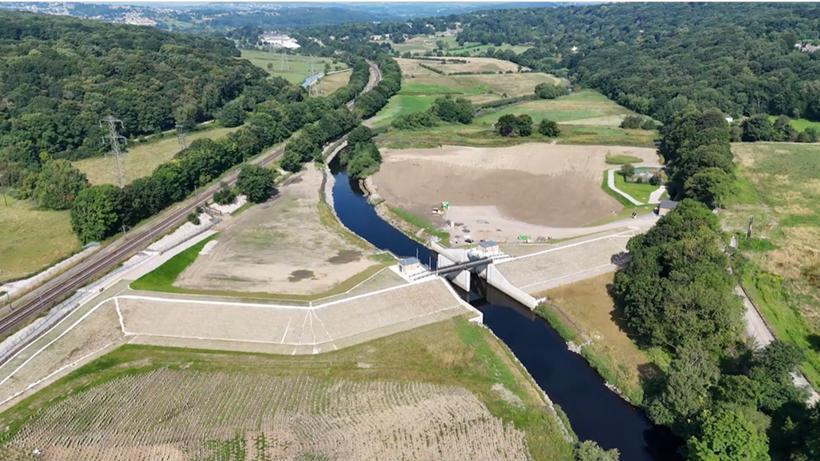
An example of successful local community engagement was demonstrated during the planning of Calverley storage reservoir as part of LFAS (Figure 19) Feedback from the community directly influenced the siting of the reservoir’s control building, which was ultimately positioned alongside the eastern edge of the flood storage reservoir This location not only aligned with community preferences but also offers clear visibility of the reservoir
It is important to remember that the risk of flooding can never be eliminated, so helping people to manage their own risk forms a vital part of our strategy for managing flood risk.

Minimise flood damage and demonstrate resilience, adaptability, and ambition by promoting continuous improvement into delivery, drawing on lessons learned, case studies, and best practices.
Utilise high-quality data to inform decision-making and deliver affordable, effective flood alleviation measures.
We are looking to improve how we collect, manage, utilise and share information to support our flood risk activities Key measures contributing to this ambition include recording our actions, why we undertake them and the benefits they provide. We also seek to source information from other organisations and the public to support our activities. We then pass on the value of our information by sharing it with the public and our risk management partners.
Such an approach ensures our activities are executed intelligently and transparently, founding our decisions upon sound information, and improves collaboration with our partners. Measures which work towards this ambition include learning from real-life flooding by recording and investigating events. As well as maintaining a flood risk asset register which identifies key flood risk assets and who is responsible for their maintenance.
Careful planning of future flood risk management actions is essential to maximise funding opportunities This can be significantly advanced by adopting a risk-based approach and fostering strong partnerships To build on these foundations and ensure maximum effectiveness, future Plans and measures should maintain clarity, momentum, and accountability by applying the SMART method as outlined below.
Specific
Measurable
Goals are clearly defined. This helps stakeholders understand what needs to be achieved.
Achievable
Progress can be tracked using quantifiable indicators, allowing for performance monitoring, and evidence-based reporting.
Relevant
Measures are realistic and attainable within available resources and constraints. Promoting efficient use of resources.
Time-bound
Measures are aligned with broader strategic priorities and local requirements, ensuring that efforts contribute meaningfully to flood risk reduction and community resilience.
Each measure has a clear deadline, which helps maintain momentum, prioritise actions, and evaluate success within a defined timeframe.
This LFRMS aims to engage with communities and clearly communicate how the people of Leeds can work together to manage the risk of flooding in the Leeds District The purpose of the Strategy is to:
- Explain the role of organisations involved in flood risk management
- Provide an overview of flood risk in Leeds
- Set out the Vision for Leeds for managing local flood risk.
- Define the Strategy through objectives and approaches to achieve the Vision for Leeds.
- Demonstrate how the Strategy supports wider environmental, social and economic objectives.
While all sources of flooding must be monitored and managed, surface water flood risk is an area where Leeds can make significant improvements. The Strategy objectives will help achieve the city’s Vision by providing a clear framework from which a future plan can be developed. The Plan will sit below the Strategy but contain the detail that supports the implementation of the Strategy, ensuring it is actionable and effective.
Table 4 Summary of the objectives and approaches outlined as part of the Strategy
Objective
Objective 1: Champion innovative and affordable approaches to flood protection
Objective 2: Embed flood & climate risk resilience in all aspects of urban planning and regeneration
Objective 3: Strengthen collaborative partnerships
Objective 4: Enhance organisational capability and whole-life delivery of flood risk management
Objective 5: Engage and empower communities in flood risk awareness and decision-making
Objective 6: Improve evidence-based understanding and delivery of flood risk solutions
Approach
- Make flood risk management approaches proportionate and risk based
- Integrate innovative projects that deliver multiple benefits
- Planning should ensure new developments assess and manage flood risk, promote climate resilience, and incorporate sustainable designs to reduce risk and promote growth
- Foster dynamic partnerships through clear procedures and responsibilities
- Establish a robust structure of governance for effective co-operation and consistency with wider strategic plans
- Manage an up-to-date flood risk asset register to proactively identifying potential issues
- Increase awareness of local flood risk
- Encourage active citizenship
- Improve recording and sharing of actions taken towards flood risk management
- Use the SMART method to develop further flood risk management plans
Flood and Coastal Erosion Risk Management: Policy Statement, Defra, 2020
Water Sensitive Urban Design in the UK, Ciria, 2013
Mansfield: designing the UK’s largest sustainable drainage scheme, AECOM, N/A
Mansfield Flood Resilience, Mansfield District Council, 2025
National Standards for SuDS, DEFRA, 2025
Brisbane’s Total Water Cycle Management Plan, Brisbane City Council, 2013
Biodiversity Net Gain An introduction to the benefits, Natural England, N/A
The North Glasgow Integrated Water Management System: A Review, CREW, 2016
Level 1 Strategic Flood Risk Assessment, Leeds City Council, 2022
Flood Map for Planning, Environment Agency, 2025
Reservoir Flood Extents, Environment Agency, 2025
Aire Resilience Company, N/A
National Planning Policy Framework, GOV.UK, 2025
Living on the Edge, Environment Agency, 2007
European Strategic Environmental Assessment Directive, European Commission, 2001
Leeds Flood Risk Assets, Leeds City Council, 2025
Priority/ Current Phase
Design/ Construction
2026/27 Thorner Beck Flood Alleviation Scheme and Natural Flood Managementdesign and implementation
Implementation 2025/26/27
Farnley Wood Beck Natural Flood Managementimplementation
Implementation 2025/26 Sheepscar Creative and Community Interpretation Scheme - implementation
Design 2026/27/28 Wortley Beck Flood Alleviation Scheme - design and implementation
Feasibility
(if
Progress/Comments (reference other sources of information)
£1.7m Thorner Flood risk from Thorner Beck. Funding secured for a study to develop flood storage upstream of the village as well as NFM features. Next stage of detailed design, business case and planning application to be undertaken. Once funding secured construction expected 2026/27.
£950k
£49k
£22.8m
Farnley Wood Beck Yorkshire Wildlife Trust commissioned to undertake a NFM survey in Farnley Wood Beck. Business Case and funding agreed with WYCA. Starting on site early 2026. Local Levy also contributed £100k towards the scheme.
Sheepscar Working with local charity Mafwa and artist to undertake a series of local community workshops exploring themes of flood risk and climate change. To result in an interpretive arts piece to be sited in Sheepscar.
Wortley Beck Flooding risk to over 200 residential properties and the outer ring road. Work in partnership with the Environment Agency to develop a detailed flood alleviation scheme that integrates with all sources of flooding. Completing the reservoir safety feasibility and then commissioning the next stage of outline design, planning application, business case.
Potternewton Surface Water Flood Alleviation Scheme feasibility £50k Potternewton Surface water flooding to residential properties, Potternewton Park and Newton Road. Funding secured for study here, exploring other funding options including developing a business case with YWS to undertake a scheme.
Priority/ Current Phase
Feasibility 2025/26/27
Feasibility 2025/26/27
Meanwood Surface Water scheme - feasibility and design
£375k
Feasibility 2026/27
Feasibility 2025/26/27
Meanwood Property Protection - surveyfeasibility
Meanwood NFM Schemefeasibility
£0-350k
£145k
Meanwood Valley Farmfeasibility £97k
Feasibility 2025/26 Lin Dyke Catchment Assessment - Upper and Middle catchments feasibility
Feasibility 2025/26 Wyke Beck Catchment Assessment Phase 2 feasibility
£TBCk
Progress/Comments (reference other sources of information)
Meanwood The Meanwood Beck catchment is situated in the north of Leeds stretching from Golden Acre park down through to the confluence of the watercourse with the River Aire at Crown Point weir, an extensive study has been undertaken to develop an option for the fluvial flood risk in the catchment. However, there are also large areas of the urban catchment which are at significant risk from smaller watercourses and surface water. This risk was highlighted during a flood event in May 2024, when properties flooded during thunderstorm activity from both surface water and the resulting rise in levels in the beck
Meanwood Property Level protection survey to be commissioned to undertake a survey of up to 60 residential properties including Meanwood Valley Farm (FLIP funding). Potential for business properties to be surveyed in the future. Implementation of measures subject to funding.
Meanwood Commission to undertake a NFM survey in Meanwood.
Meanwood
Garforth & Kippax
£TBCk
Communities along Wyke Beck
Local Levy funding for undertaking a blue green demonstrator at the farm. Feasibility commission to examine the first stage of work.
Continuation of work included in Section 19 Report, regarding flooding of the SE Leeds area in August 2014 and 2015. Further modelling undertaken and results under evaluation. Funding options have been explored but as yet no economically viable scheme has been identified. However, we continue to explore options.
Continuation of work carried out by both LCC & Environment Agency. This has now progressed into a catchment wide approach. Exploring resourcing options to take this forward and to request potential funding from the Environment Agency
Priority/ Current Phase Scheduled phase Completion Date
Pre Outline Business Case 2025/26
Guiseley Surface Water Flood Alleviation Scheme feasibility
Ongoing - LCC Significant Maintenance
Completed 2025 Wharfedale Flooded Communities Feasibility Study
Completed 2025 Optioneering for Meanwood Beck Flood Alleviation Scheme
£TBCk
Location (if applicable)
Progress/Comments (reference other sources of information)
Guiseley Surface water flooding to properties in Guiseley. Levy funding secured to support ongoing study into flood risk and options to address this undertaken. CCTV survey has been undertaken.
Across the District Continuation of regular maintenance of Watercourses and HotSpots
Completed 2025 Sheepscar Beck Asset Remediation Work
£322k
Completed 2024 Leeds Flood Alleviation Scheme Phase 2, River Aire City Centre to Upper Catchment
Completed 2023 Farnley Wood Beck Flood Alleviation Scheme
£10-15m
Collingham, Linton, Wetherby, Thorp Arch
Linked to wider catchment partnership work with the Environment Agency, further modelling work assessed flood risk building on the public engagement undertaken in Summer 2021. However, an economic case could not be made for a scheme.
Meanwood Beck Flood risk from Meanwood Beck to residential properties and businesses. Local levy funding secured to carry out investigation into options for a flood alleviation scheme here. Extensive modelling optioneering for potential flood storage areas for further investigation and initial design. However no viable scheme is possible. This work has now turned into Meanwood schemes for Meanwood Surface water, Property Flood Resilience and NFM.
£1.5m Sheepscar refurbishment
Scheme is to carry out repair works to assets along Sheepscar Beck through the city centre and provide protection of business Scoping and design of required refurbishment underway with tender and onsite in April 2024. Main works on Sheepscar is now completed and a small separate scheme commissioned for Gipton Beck.
£150m River Aire - City Centre to Upper Catchment Phase 2 of the Leeds FAS is now complete
£1.017m
Cottingley Flood risk to residential areas, developer contribution secured of £300k. Scheme progressed in 2022/23 to remove culvert and increase capacity, protecting 15 properties. Completed February 2023
Priority/ Current Phase
Progress/Comments (reference other sources of information)
Completed 2022/23 Queen Street Culvert 44k Allerton Bywater In extreme storm events a culvert overtops and spills out across the public right of way next to St Aidens Nature Reserve. Section 106 Agreement monies utilised. Growbags instead of a concrete headwall which will green up and naturalise over time and reduced the cost and the carbon footprint of the scheme. Some tree planting in March 2023 completed the scheme.
Completed 2020 Killingbeck Meadows Flood Alleviation Scheme
£3m Halton Moor Flooding to residential and commercial areas from Wyke Beck. Accelerated scheme due to combining the benefits of releasing development sites (11 housing sites and land within the Enterprise Zone and providing green infrastructure improvements to a Local Nature reserve as well as providing flood risk reduction, the completed scheme will become a registered flood storage area under the Reservoirs Act. This forms part of a joint Wyke Beck Programme delivering housing growth from Brownfield land and Local Nature reserve and green space improvements.
Completed 2020 Hawthorn Terrace Flood Alleviation Scheme
Superseded 2020 Investigate the interaction between the Leeds and Liverpool Canal and the River Aire.
Completed 2019 Lin Dyke Catchment Assessment - Upper and Middle catchments
Completed 2017 Carry out flood warning feasibility studies for Wortley Beck and Meanwood Beck and implement findings.
£100k West Garforth Initial scheme completed, but further defects with existing assets and connected infrastructure identified so further works needed and being designed
£10k River Aire and Liverpool Canal
This study should identify the potential for managing this interaction to ensure that flood risk is managed effectively. This measure is listed in the Aire Catchment Flood Risk Management Plan for the Leeds Policy Unit - to be progressed by 2030. - this was included in the scope of Phase 2 of the Leeds Flood Alleviation Scheme
£1.25m Garforth & Kippax Continuation of work included in Section 19 Report, regarding flooding of the SE Leeds area in August 2014 and 2015, design works are continuing to be progressed as schemes are identified
£10k Wortley Beck and Meanwood Beck This measure is listed in the Aire Catchment Flood Risk Management Plan.
Priority/ Current Phase Scheduled
Completed 2017 Leeds Flood Alleviation Scheme Phase 1, River Aire City Centre
£50.6m River Aire - City Centre Scheme Completed
Completed 2017 Cotton Mill Beck Culvert, Valley Road N/A Morley Scheme passed to network rail
Completed 2018 Westfields, Allerton Bywater
£502K Allerton Bywater Scheme Completed
Completed 2017 Glebelands Recreation Ground £100k Garforth Scheme Completed
Completed 2017 Barley Hill Recreation Ground (Phase 2)
Completed 2017 Ramsden Street, Kippax, Flood Alleviation Scheme(Local Levy & FDGiA)
Completed 2014 Lowther Road, GarforthCulvert Improvements
Completed 2014 Wellhouse Drive Flood Alleviation Scheme
Completed 2014 Culvert Headwall Repair Scheme - (Local Levy)
Completed 2013 Oakdene, Watercourse Improvements
Completed 2012 Barley Hill Recreation Ground - (Local Levy)
£100k West Garforth Scheme Completed
£305k Kippax Scheme Completed
£220k Garforth Scheme Completed
£50k Gledhow Scheme Completed
£50k Otley Scheme Completed
£20k Swillington Scheme Completed
£75k West Garforth Scheme Completed
Priority/ Current Phase Scheduled phase
Completion Date
Completed 2011 Flood Alleviation SchemeLeeds Road (Allerton Bywater) pumping station (local levy)
Completed 2011 Newton Road property protection and resilience scheme
Completed 2011 Lower Wortley - property protection and resilience scheme
Completed 2011 Church Lane, Bardseyproperty protection and resilience scheme
Completed 2011 Dean Park Drive, Drighlington - property protection and resilience scheme
£30k Allerton Bywater Scheme Completed
£20k Newton Road, Potternewton Scheme Installed
£20k Lower Wortley Scheme Installed
£20k Bardsey Scheme Installed
£20k Drighlington Scheme Installed