Hertsmere Borough Council
Hertsmere Local Plan Draft Regulation 18 Consultation Document
Chapter 3 Vision, Strategic Objectives and Spatial Strategy
3.1 This is an important part of the new Local Plan and sets out the Council’s positive vision for future growth and how supporting infrastructure will be delivered to meet needs and secure successful and sustainable placemaking -
Hertsmere’s Strategic Context
An Appropriate Spatial Strategy
Hertsmere’s Strategic Context
3.2 Hertsmere is located within the South West Herts strategic planning area, which includes the district and borough councils of Dacorum; Hertsmere; St Albans City; Three Rivers; and Watford. The councils have worked closely together over several years to plan for the long-term future of the area through the formulation of a Joint Strategic Plan. Local Government Reorganisation has meant that this work will progress once the geographies for the new strategic authorities are determined later this year.
3.3 Hertsmere also immediately adjoins the three outer London Boroughs of Barnet, Enfield and Harrow. Hertsmere’s hinterland geography remains a strategic consideration – specifically in respect of the emerging new London Plan. That latter document is seeking to meet the London’s housing needs in full. Whilst that suggests that there will not be a direct impact on the Borough, in terms of the quantum of housing it delivers, there may be other matters, such as meeting wider strategic industrial employment needs that need to be considered.
3.4 The Council is positively engaging with its neighbours within Hertfordshire and with the London boroughs to the South. That engagement process will seek to identify and confirm relevant strategic cross boundary matters that Hertsmere shares with its neighbours. It is anticipated that the outcome will
Hertsmere Local Plan Draft Regulation 18 Consultation Document
be a suite of statements of common ground, between the Council and its neighbours that set out the agreed position on relevant strategic matters and any actions that will be required. It is anticipated that this will provide appropriate and proportionate evidence that the legal requirements associated with the duty to co-operate have been met – as required by National Planning Policy and the Localism Act.
15. Question: Do you agree with the proposed approach towards meeting the legal requirements for the Duty to Co-operate in relation to strategic cross boundary matters? Yes/ No
16. Question: If you disagree, please set out the additional actions that you consider the Council needs to undertake to ensure that it meets the Legal Requirements associated with the Duty to Co-operate?
An Appropriate Spatial Strategy
3.5 National Planning Policy12 requires that to be sound a local plan will include an appropriate spatial strategy that as a minimum seeks to meet the objectively assessed needs of Hertsmere in full13 A key starting point in determining the spatial strategy for Hertsmere is understanding the current settlements and categorising them to present a settlement hierarchy This work builds upon outputs undertaken with partners across South West Hertfordshire as well as more recent studies undertaken by Hertsmere. Figure 1 below summarises the categories identified with further detail on each provided below.
12 National Planning Policy Framework (December 2024) Paragraph 36 b)
13 National Planning Policy Framework (December 2024) Paragraph 36 a).
Hertsmere Borough Council
Hertsmere Local Plan Draft Regulation 18 Consultation Document
Table 1: Summary of categories used in the South West Hertfordshire Settlement Hierarchy
Category I Settlements: Main Centres of Population
Category II Settlements: Large Towns
Category III Settlements: Small Towns
Category IV Settlements: Large Villages and Branch Line Villages
Category V Settlements: Villages
Category VI: Below Threshold Settlements
3.6 There are no Category I settlements in Hertsmere. The nearest being neighbouring settlements of St Albans and Watford. Borehamwood is classified as a Category II settlement, being classified as a Tier I Settlement. Potters Bar is Category II settlement, being classified as a Tier II settlement. It is highlighted that Bushey, with a resident population greater than Potters Bar is also classified as a Tier II settlement. However, it is noted that Bushey has no railway station14, it is reliant upon highway networks and has a less discernible centre. Radlett has the smallest resident population and is classified as a Category III/ Tier III settlement. In contrast to Bushey, it is located on a railway mainline, with good connections to central London and at least has a legible centre. It is noteworthy that London Colney, a settlement in adjoining St Albans is also classified as a Category III
14 Within Hertsmere – Bushey does have a named station that is factually located in neighbouring Watford Borough
Hertsmere Local Plan Draft Regulation 18 Consultation Document
settlement that does not have a direct connection to the railway network –and is reliant upon access via the highway network
3.7 The hierarchy identifies Shenley as a Large Village – albeit acknowledging that it has a limited range of services and facilities. Specifically, it has no secondary school and limited employment opportunities. The Borough’s remaining settlements all fall within Category V – Elstree Village and South Mimms – and Category VI below threshold settlements. These are considered unsustainable locations for development and are unlikely to meaningfully contribute to meeting Hertsmere’s future growth needs.
3.8 This approach to the Borough’s settlement hierarchy has been further assessed through technical evidence set out under Document E2 Settlement Hierarchy and Services (January 2026). The Council considers that this approach is sound.
17. Question: Do you agree with the proposed settlement hierarchy and the technical evidence that supports it? Yes/ No
18. Question: If you disagree, please set out an alternative hierarchy. Please provide a clear justification why your approach should be considered sound.
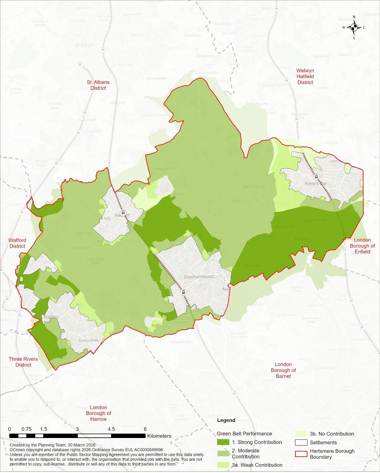
3.9 Currently the most visibly significant constraint to growth across Hertsmere, within the context of identifying an appropriate spatial strategy, is the current extent and permanence of the Green Belt. Consequently, the Council’s proposed appropriate spatial strategy responds by seeking to optimise growth and regeneration opportunities within the existing urban areas to minimise the need to release Green Belt Furthermore, in circumstances where the release of land from the Green Belt is considered necessary to ensure needs are met in full, the Spatial Strategy will seek to optimise site
Hertsmere Local Plan Draft Regulation 18 Consultation Document
capacity. This approach considers national planning policy15 and guidance16 on development densities, with the specific objective of further minimising the need to release additional land from the Green Belt in the long term.
3.10 National planning policy17 states that the Green Belt is already established. It also provides the policy context for considering proposals that impact upon its extent. For clarification, the emerging Local Plan does not include policies that are specific to the Green Belt – as this matter is sufficient addressed through national planning policy.
3.11 The plan-making process has prepared appropriate and proportionate technical evidence that assesses the Green Belt across Hertsmere. That work has included engagement with relevant neighbouring planning authorities. The technical evidence is set out under Document E1 Green Belt Study (April 2026). The Council considers that the approach to assessing the Green Belt is sound.
19. Question: Do you agree with the approach taken in assessing Hertsmere’s Green Belt? Yes/ No
20. Question: If you disagree, please set out how you believe this matter should be considered for it to be found sound. Please justify your response.
3.12 The technical evidence demonstrates that there are parts of the Borough’s designated Green Belt that perform strongly against the purposes as set out by national planning policy18. These strongly performing areas are assessed
15 National Planning Policy Framework (December 2024) Paragraph 130.
16 National Design Guide 2021.
17 National Planning Policy Framework (December 2024) Paragraph 144.
18 National Planning Policy Framework (December 2024) Paragraph 143.
Hertsmere Borough Council
Hertsmere Local Plan Draft Regulation 18 Consultation Document
through Document E1 Green Belt Study (April 2026). The technical evidence has informed the preparation of the Local Plan.
3.13 Connections to infrastructure networks have informed consideration on an appropriate spatial strategy. This being particularly relevant in terms of access to sustainable travel networks, with connections to higher Tier centres to the North and South (particularly London). Access to the strategic highway network, the M1, M25 and A1 (M), is a parallel consideration, particularly in terms of strategic industrial employment uses, the film industry, strategic logistics, and datacentres. Potential connectivity to the Hertsmere Local Cycling Walking Infrastructure Plan (LCWIP) investment is also a consideration.
3.14 Equally, many parts of the Borough, especially those places outside of the four main settlements, experience relatively poor levels of accessibility to key infrastructure networks. This is particularly the case in respect of access to sustainable travel networks and as such much of the Borough, outside of the four main towns, provides limited scope for genuinely sustainable placemaking.
3.15 The Council continues to work positively with infrastructure partners and the development industry to ensure that the proposals that will deliver the planned-for growth will be supported by a proportionate investment in necessary infrastructure networks. It is anticipated that this will be evidenced through statement of common ground (between the partners), technical evidence (such as transport modelling), and the infrastructure delivery plan19. The Council considers that this is a sound approach.
19 The Borough-wide Infrastructure Delivery Plan is being prepared as part of the Local Plan‘s wider technical evidence base. It will be published in support of the Regulation 19 stage of the process.
21. Question: Do you agree with the approach being taken towards infrastructure networks and their capacity? Yes/ No
22. Question: If you disagree, please set out what actions need to be taken to ensure soundness? Please justify your response.
The Spatial Strategy
3.16 The Spatial Strategy considers the Borough’s settlement hierarchy, the capacity (within settlements) to accommodate growth and existing infrastructure networks. The Strategy distributes growth in accordance with the settlement hierarchy and is also informed by an understanding of relevant constraints and land use designations. The spatial strategy envisages that most growth, specifically during the first five-years of the plan period will be distributed to the Borough’s two higher order settlements of Borehamwood and Potters Bar, with a focus upon intensification through urban regeneration.
3.17 The Spatial Strategy will seek the regeneration of the Borough’s high order settlements – through the comprehensive redevelopment of their main town centres. Both settlements have several strategic level urban site allocation opportunities – comprised of sites/uses that have or will reach the end of the lifespan during the plan period. These sites typically consist of single commercial, or social infrastructure uses that are currently developed to suboptimal densities. Examples include Borehamwood Town Centre Retail Park, several large format food stores, and several time-expired office buildings. These sites provide opportunities for town centre regeneration through their intelligent redevelopment for a complimentary mix of uses. They also provide good opportunities to secure higher design quality, green infrastructure and investment in public realm. By fully optimising their potential – through the application of appropriate verticality and high-quality design – these site allocations serve as the template/baseline for densification that could be secured through wider transformation. By
providing a focus upon the transformation and intensification of sites within existing urban areas the spatial strategy will seek to reduce the need, and consequential impact, to release greenfield sites from the Borough’s Green Belt.
3.18 In addition, the Strategy will bolster supply and delivery from new strategic urban extensions, and smaller-scale urban extensions that surround and immediately adjoin Borehamwood and Potters Bar. These will be physical extensions to the two settlements, the largest of which will be comprised of a mix of residential, main town centre, employment, open space, green infrastructure and travel networks. These new communities will functionally link and support wider regeneration within the two settlements. They will build upon the intensification being achieved elsewhere – having an appropriate mix of densities – with their centres developed at heights and densities proportionate to their status. The Council’s own evidence suggests that these types of site allocation could deliver a complementary mix of uses and infrastructure at development densities of at least 23 units/ per ha (gross). This being consistent with similar development sites being delivered elsewhere in the East of England. These urban extensions should look forward towards development typologies that will be required at their point of delivery – anticipated to be between years 6 – 15 of the plan-period. It is anticipated that these site allocations will be delivered in parallel with strategic urban site allocations and will collectively deliver the step-change in growth required for Hertsmere.
3.19 The Strategy considers that the Borough’s remaining two settlements, Radlett and Bushey would take a lesser level of growth – in the form of smaller scale urban extensions and intensification through windfall and infill development. This would reflect the typologies found within those settlements – low density and high value properties arrayed in a suburban/ commuter-belt townscape – and their limited range of main town centre uses and community facilities. Both settlements could consider modest urban
extensions that could also begin to progressively intensify their respective development typologies – through future windfall development.
3.20 The Strategy could also support a new settlement that could begin to deliver growth later in the plan period and continue into the next. This option could exploit an opportunity provided by land to the east of London Colney, which is itself located in the adjoining St Albans City. The Strategy could consider this opportunity as a source of strategic housing supply, as an important delivery vehicle that sustains the step-change in housing (supply and delivery) well into the next plan period and secures significant infrastructure network and capacity improvements. It could also serve to define the extent of the Green Belt in the longer term – along the southern extent of St Alban’s and east of what is currently London Colney. That new boundary could be maintained in permanence by the delivery of new accessible strategic open space and/ or strategic ecological designations.
3.21 The Strategy considers the remainder of the Borough – specifically the smaller rural settlements (such as Shenley) - as being inappropriate and unsustainable locations for growth/ place-making during the plan period. The strategy explicitly seeks to protect these places from inappropriate levels of growth by directing it to the places set out above. The possible exceptions to this approach could be single infill dwellings, delivered as self or custom build housing; and/or rural exceptions sites that deliver affordable housing that meets specific local needs. Major housing proposals (ten or more units) will be strongly resisted this is specifically the case with specialised forms of housing – elderly person accommodation and co-living – which must be located within existing urban areas, where they will benefit from access to existing infrastructure networks.
3.22 A further possible exception could arise where a proposal seeks to justify itself based on improving housing delivery. Such circumstances could occur during years 1 – 5 of the plan-period. When such opportunities arise, the
Council will require that such proposals demonstrate extremely robust evidence that delivery will take place, and make a meaningful contribution to performance, during the first three years of the proposal’s consent20. This is a high bar for proposals to cross.
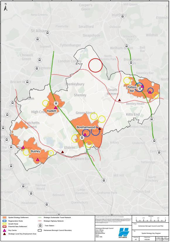
3.23 The Spatial Strategy will be expressed through a Key Diagram. This will identify the four settlements towards which future growth will be directed. It further illustrates how growth will be delivered by identifying the broad locations of regeneration nodes, for example Borehamwood Town Centre and Elstree Way, and growth nodes, the latter broadly equating to the location of future site allocations. The Diagram will also identify key centres21 , strategic employment locations, and the strategic sustainable travel and highway networks that connect the Borough’s places A Key Diagram is included below for illustrative purposes. It identifies the anticipated locationsfor the Borough’s Regeneration Nodes. It has assumed possible locations for Growth Nodes. For clarity, these locations will only be finalised once the emerging Local Plan’s site allocations have confirmed following the current consultation.
20 For clarity, the Housing Delivery Test measures performance over a three-year reporting period. Most consents will have a three year lifespan, during which commencement must begin. Consequently, for a consent to have a meaningful positive impact on performance, it must deliver at scale within its first three years (following consent). This approach seeks to encourage commencements that rapidly progress to delivery at scale.
21 For clarity, these are where the Borough’s main town centre uses, as defied under Use Class E, are located.
Hertsmere Borough Council
Hertsmere Local Plan Draft Regulation 18 Consultation Document
3.2: Spatial Strategy Key Diagram
23. Question: Do you consider the proposed spatial strategy for Hertsmere, an appropriate strategy that will deliver successful and sustainable place making; planned-for growth; meet the Borough’s development needs; and necessary infrastructure investment during the plan period? Yes/ No.
24. Question: Do you have an alternative spatial strategy that could be appropriate for Hertsmere, which will demonstrably deliver successful and sustainable place making; planned-for growth; meet the Borough’s development needs; and secure necessary infrastructure investment during the plan period? Please provide details of your alternative appropriate strategy. Ensure that your response is justified by proportionate evidence.
Reasonable Alternatives
3.24 The emerging Local Plan’s Sustainability Appraisal process will test reasonable alternatives. A Sustainability Appraisal of the proposals set out in the Consultation Document forms part of the plan preparation process under Regulation 18 and is also open to consultation.
3.25 The proposed Spatial Strategy does lend itself to a degree of further evolution. These possible paths could be considered as reasonable alternatives for the purpose of Sustainability Appraisal.
3.26 The most noteworthy of these alternatives is that provided by the new town opportunity, at London Colney/Bowmans Cross. Specifically, if the site were to begin to come forward and deliver new homes at scale earlier in the plan period it could serve to accelerate housing delivery, either comfortably securing the Borough’s housing requirement early or providing a modest uplift during the plan period. This uplift in supply, delivery and intensification could be further enhanced (and ensured) through the early delivery of necessary supporting community infrastructure at the site of the new town.
Hertsmere Local Plan Draft Regulation 18 Consultation Document
This is specifically the case in terms of improved sustainable travel network connectivity between the new town, St Albans and Potters Bar. It is highlighted that this could provide an opportunity for higher densities to begin delivery early in the process – rather than waiting for a critical mass point to be reached.
3.27 A further reasonable alternative could arise in respect of how growth is delivered in Bushey. Future growth in Bushey could focus upon improving connectivity to the infrastructure networks available in neighbouring Watford, such a relationship could allow the settlement to grow as a satellite serving the Category I settlement to its immediate northwest. Higher levels of growth at Bushey could serve to fuel investment in necessary sustainable travel connections into and out of Watford. Given the apparent readiness of many of the urban extension opportunities that surround Bushey, this reasonable alternative could deliver at scale during years 6 – 10 of the plan-period.
25. Question: Do you agree that the proposed spatial strategy could enable the two reasonable alternatives identified above? Yes/ No.
26. Question: Are there any other reasonable alternatives that could arise during the delivery of the proposed spatial strategy?